Effective Utilization of Synthetic Aperture Radar (SAR) Imagery in Rapid Damage Assessment
|
|
|
- Marylou Todd
- 5 years ago
- Views:
Transcription
1 Effective Utilization of Synthetic Aperture Radar (SAR) Imagery in Rapid Damage Assessment Case Study Pakistan Floods SUPARCO M. Maisam Raza, Ahmad H. Rabbani
2 SEQUENCE Flood Monitoring using Satellite Technology Synthetic Aperture Radar for Flood Monitoring Copernicus Program - ESA SAR in Disaster Management-Case Study Conclusion / Recommendations
3 SEQUENCE Flood Monitoring using Satellite Technology Synthetic Aperture Radar Data for Flood Monitoring Copernicus Program - ESA SAR in Disaster Management-Case Study Conclusion / Recommendations

4 Space Application Centre for Response in Emergency and Disasters (SACRED) The centre provides space based information to national / provincial disaster management agencies Rapid assessment of the extent of natural disasters and damages to human lives, property and infrastructure. The centre also provides assistance to regional countries in case of natural disasters. Web: disasterwatch.sgs-suparco.gov.pk


5 Geospatial Technologies for Flood Management Inundation forecasting & warning Hazard /Risk Mapping Capacity Building Mitigation Preparedness Operational Support Rapid Damage Assessment Detailed Damage Assessments Recovery Response Rapid Assessment and Information Dissemination


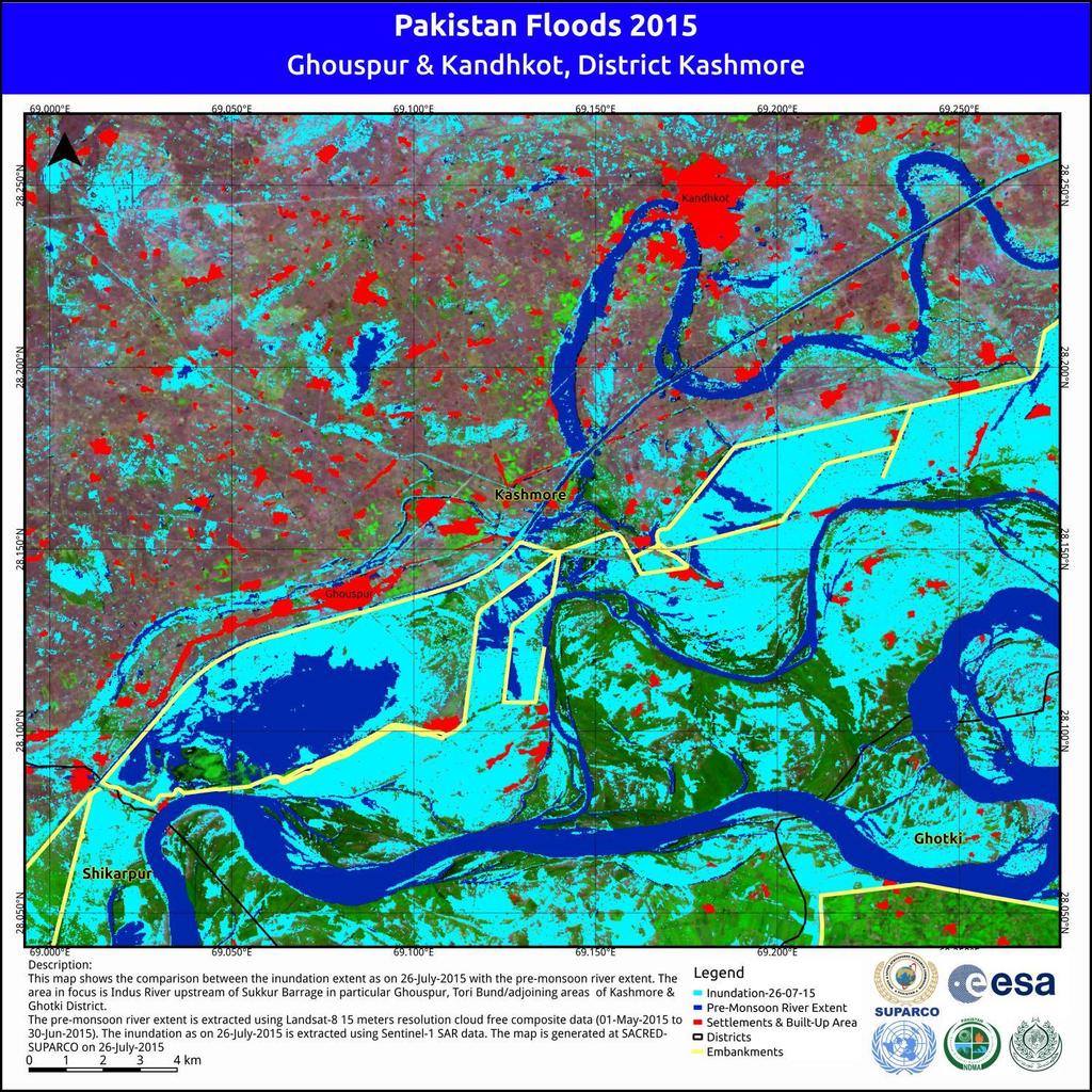
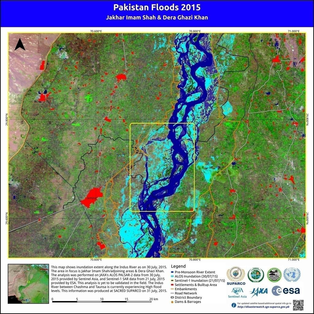
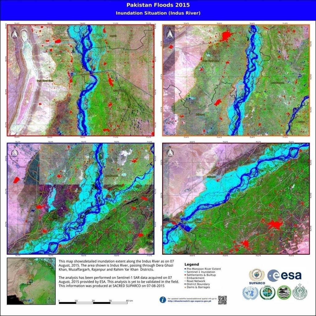
6 Regular River Monitoring SUPARCO undertakes regular river monitoring using satellite technology to monitor the flooding events across the country. Rapid response maps are generated and forwarded to the disaster management agencies and line departments to undertake the relief and rescue activities. The maps provide the following information Inundation Extent Damaged Roads Affected Settlements Affected Agriculture Status of Flood Protection Structures

7 Regular River Monitoring As the flooding typically occurs during the monsoon season, presence of persistent cloud cover makes regular river monitoring using optical satellite data, a challenging task MODIS Time Series showing Heavy Cloud Cover

8 Sequence Flood Monitoring using Satellite Technology Synthetic Aperture Radar Data for Flood Monitoring Copernicus Program - ESA SAR in Disaster Management-Case Study Conclusion / Recommendations 01-Mar-18


9 Penetration of SAR through Clouds Penetration of microwave radar through clouds make it an ideal choice for space based disaster monitoring during the monsoon season Radar Imagery Optical Imagery 17 July 2016

10 Radar for Earth Remote Sensing Atmosphere is Generally Transparent for Microwave Frequencies Microwaves are Cloud-penetrating Independent of Atmospheric Conditions(dust/Haze) Affected by Rainfall Attenuation Can Operate Day & Night Works under Almost All Weather and Environmental Conditions Most common bands are L, X & C Bands Lillesand et al.(2003) 3rd Summer School on Earth Remote Sensing with SAR Dr. Waqas A. Qazi


11 Penetration Properties of Radar Bands Rain Cell Penetration Ground Target Penetrations X - Band C - Band Target Reflections L - Band Richards (2009) 3rd Summer School on Earth Remote Sensing with SAR Dr. Waqas A. Qazi
12 Choices of Frequency Bands 3rd Summer School on Earth Remote Sensing with SAR Dr. Waqas A. Qazi
13 Choices of Frequency Bands 3rd Summer School on Earth Remote Sensing with SAR Dr. Waqas A. Qazi

14 Space Based Radar Platforms..Few Examples 3rd Summer School on Earth Remote Sensing with SAR Dr. Waqas A. Qazi
15 SEQUENCE Flood Monitoring using Satellite Technology Synthetic Aperture Radar Data for Flood Monitoring Copernicus Program - ESA SAR in Disaster Management-Case Study Conclusion / Recommendations 01-Mar-18

 Open source platform available for accessing data Cloud Penetration")
16 Sentinel 1 Copernicus Program - ESA Sentinel-1 is a Synthetic Aperture Radar (SAR) mission Providing continuous All-Weather Day-and-Night Imagery Operates at C-band (centre frequency: Ghz) Open source platform available for accessing data Cloud Penetration


17 Sentinel 1 Copernicus Program - ESA Sentinel 1 A and Sentinel 1 B Revisit time 6 days at the poles Operating in four exclusive imaging modes with different spatial resolutions and coverage Interferometric Wide Mode with a swath width of 250 km Revisit Time
18 SEQUENCE Flood Monitoring using Satellite Technology Synthetic Aperture Radar Data for Flood Monitoring Copernicus Program - ESA SAR in Disaster Management- Pakistan Floods 2015 Conclusion / Recommendations 01-Mar-18

19


20 SENTINEL-1 Data Downloading Copernicus Open Access Hub Sensing Period Ground Range Detected Interferometric Wide Mode


21 Sentinel-1 SAR Data Processing Workflow Read (IW-GRD) Radiometric Calibration Sentinel-1 Toolbox Terrain Correction Speckle Filter Linear to db Conversion Sigma0.img Quantum GIS Training Samples Classification Raster to Vector Noise Removal Inundation Layer Standard S1 processing algorithm available at UN-SPIDER recommended practices knowledge portal

22 Sentinel-1 Processing in S1-Toolbox 01-Mar-18
23 Sentinel-1 Processing Output - Image Raster Mountains River Channel Shadows Desert Crop Land


24 Sentinel-1 Processing Output Image Raster Classified Raster Processed Vector 01-Mar-18
25

26 Settlement Fish Ponds/Agriculture Inundation Embankment Normal River Flow
27
28
29 SEQUENCE Flood Monitoring using Satellite Technology Synthetic Aperture Radar Data for Flood Monitoring Copernicus Program - ESA SAR in Disaster Management- Pakistan Floods 2015 Conclusion / Recommendations 01-Mar-18
30 Conclusion/Recommendations Sentinel 1 for flood monitoring particularly during monsoon season Interferometric Wide mode - an excellent choice for mapping riverine flooding IW mode has limited applications in the hilly/mountainous areas therefore high res (strip map) mode may be made available publicly Various sources of errors in SAR data (Foreshortening /Layover, Corner Reflections, Radar Shadows, Range Ambiguities etc) should be considered while processing data Special thanks to EU Copernicus Program, JAXA and USGS for provision of various datasets for flood monitoring
31 Thank you
EXTRACTION OF FLOODED AREAS DUE THE 2015 KANTO-TOHOKU HEAVY RAINFALL IN JAPAN USING PALSAR-2 IMAGES
 EXTRACTION OF FLOODED AREAS DUE THE 2015 KANTO-TOHOKU HEAVY RAINFALL IN JAPAN USING PALSAR-2 IMAGES F. Yamazaki a, *, W. Liu a a Chiba University, Graduate School of Engineering, Chiba 263-8522, Japan
NASA Flood Monitoring and Mapping Tools
 National Aeronautics and Space Administration ARSET Applied Remote Sensing Training http://arset.gsfc.nasa.gov @NASAARSET NASA Flood Monitoring and Mapping Tools www.nasa.gov Outline Overview of Flood
Space Applications for Disaster Risk Reduction and Sustainable Development
 Space Applications for Disaster Risk Reduction and Sustainable Development Space Applications Section (SAS) ICT and Disaster Risk Reduction Division (IDD) UNESCAP Contents I. RESAP Activities 2016-2017
Copernicus Overview. Major Emergency Management Conference Athlone 2017
 Copernicus Overview Major Emergency Management Conference Athlone 2017 Copernicus is a European programme implemented by the European Commission. The services address six thematic areas: land, marine,
New Concept of Regional Cooperation in Asia for Water Disaster Management Applying Satellite Precipitation Measurement
 New Concept of Regional Cooperation in Asia for Water Disaster Management Applying Satellite Precipitation Measurement Yusuke Muraki Japan Aerospace Exploration Agency (JAXA) Mission Planning Department
Towards the use of SAR observations from Sentinel-1 to study snowpack properties in Alpine regions
 Towards the use of SAR observations from Sentinel-1 to study snowpack properties in Alpine regions Gaëlle Veyssière, Fatima Karbou, Samuel Morin et Vincent Vionnet CNRM-GAME /Centre d Etude de la Neige
Uses of free satellite imagery for Disaster Risk Reduction (DRR)
") Centre of Applied Geoscience, Disaster Risk Reduction Research Group, School of Earth and Environmental Science, University of Portsmouth, UK Uses of free satellite imagery for Disaster Risk Reduction
Centre of Applied Geoscience, Disaster Risk Reduction Research Group, School of Earth and Environmental Science, University of Portsmouth, UK Uses of free satellite imagery for Disaster Risk Reduction
Capabilities of SAR and optical data for rapid mapping of flooding events
 Capabilities of SAR and optical data for rapid mapping of flooding events Lisa Fischell 1, Daria Lüdtke 1,2 and Moses Duguru 1 1 United Nations Platform for Space-based Information for Disaster Management
Space Application in Support of Land Management for SDG Implementation
 Space Application in Support of Land Management for SDG Implementation Regional Expert Workshop on Land Accounting for SDG Monitoring and Reporting 26 September 2017 Space Application Section Information
Sentinel Asia Tsunami Working Group
 Sentinel Asia Tsunami Working Group Co-Chairman: Prof. Shunichi Koshimura Abdul Muhari, PhD 4 th Joint Project Team Meeting (JPTM 2017): Sentinel Asia STEP 3 Abdul MUHARI, PhD Ministry of Marine Affairs
Disaster RISK Management : Bhutanese Scenario
 Disaster RISK Management : Bhutanese Scenario Expert Group Meeting (EGM) on Geo-referenced Information Systems for Disaster Risk Management (Geo-DRM) and sustaining the Community of Practice (COP), Bangkok,
L i n k i n g f l o o d i m p a c t f o r e c a s t i n g a n d s a t e l l i t e r a p i d m a p p i n g i n E u r o p e
 L i n k i n g f l o o d i m p a c t f o r e c a s t i n g a n d s a t e l l i t e r a p i d m a p p i n g i n E u r o p e Francesco Dottori, Milan Kalas, Peter Salamon, Annett Wania, Ines Rivero (EC JRC)
Crisis Management and Natural Disasters Overview of JRC operational or pre-operational activities A. Annunziato, D. Al-Khudhairy
 Papagayo, Costarica 3-4 November 2009 Security Science and The Americas 1 Joint Research Centre (JRC) Crisis Management and Natural Disasters Overview of JRC operational or pre-operational activities A.
Why Hydrological Services are Important to Business
 Why Hydrological Services are Important to Business Dr. David Green Program Manager, Disasters Earth Science Division David.s.green@nasa.gov May 8, 2018 2 Communities and Areas of Intensive Risk Socio-Economic
COUNTRY PRESENTATION ON MR JAYNAL ABEDIN JOINT SECRETARY ( WORKS & DEVELOPMENT ) MINISTRY OF DEFENCE
 MINISTRY OF DEFENCE") COUNTRY PRESENTATION ON By MR JAYNAL ABEDIN JOINT SECRETARY ( WORKS & DEVELOPMENT ) MINISTRY OF DEFENCE Bangladesh Geographical Location of Bangladesh Bangladesh Country at a Glance Physical Features 1,230
COUNTRY PRESENTATION ON By MR JAYNAL ABEDIN JOINT SECRETARY ( WORKS & DEVELOPMENT ) MINISTRY OF DEFENCE Bangladesh Geographical Location of Bangladesh Bangladesh Country at a Glance Physical Features 1,230
USE OF GEOREFERENCE INFORMATION FOR DRM Arnob Bormdoi Research Associate, GIC
 USE OF GEOREFERENCE INFORMATION FOR DRM Arnob Bormdoi Research Associate, GIC CONTENTS INTRODUCTION THE IMPORTANCE OF SPATIAL INFORMATION CASE STUDIES SUMMARY INTRODUCTION The process of defining how raster
European Space Agency
 Guidelines - Guidelines how/when to interact during the WebEx session: - Due to the number of attendees, please keep always your webcam and microphone switched-off - You can use anytime the chat to all
Japanese Programs on Space and Water Applications
 Japanese Programs on Space and Water Applications Tamotsu IGARASHI Remote Sensing Technology Center of Japan June 2006 COPUOS 2006 Vienna International Centre Water-related hazards/disasters may occur
EuroGEOSS Protected Areas Pilot
 EuroGEOSS Protected Areas Pilot Max Craglia European Commission Joint Research Centre Part 1: the present MyNatura2000 Mobile app. Awareness raising & volunteered data collection. Natura2000 covers 18%
sentinel-2 COLOUR VISION FOR COPERNICUS
 sentinel-2 COLOUR VISION FOR COPERNICUS SATELLITES TO SERVE By providing a set of key information services for a wide range of practical applications, Europe s Copernicus programme is providing a step
Table ronde 5 : Cartographie d'urgence Emergency Mapping.
 Table ronde 5 : Cartographie d'urgence Emergency Mapping MapAction is an international NGO that provides maps and other information services to help humanitarian relief organisations in the field MapAction
Application of Satellite Data for Flood Forecasting and Early Warning in the Mekong River Basin in South-east Asia
 MEKONG RIVER COMMISSION Vientiane, Lao PDR Application of Satellite Data for Flood Forecasting and Early Warning in the Mekong River Basin in South-east Asia 4 th World Water Forum March 2006 Mexico City,
Evaluation of sub-kilometric numerical simulations of C-band radar backscatter over the french Alps against Sentinel-1 observations
 Evaluation of sub-kilometric numerical simulations of C-band radar backscatter over the french Alps against Sentinel-1 observations Gaëlle Veyssière, Fatima Karbou, Samuel Morin, Matthieu Lafaysse Monterey,
DRAFT Methodology for Remote Sensing and GIS Analysis for Multiple Indicator Rapid Need Assessment (MIRA)
") DRAFT Methodology for Remote Sensing and GIS Analysis for Multiple Indicator Rapid Need Assessment (MIRA) Context and background/introduction: The Multi-sector Initial Rapid Assessment (MIRA) is the first
DRAFT Methodology for Remote Sensing and GIS Analysis for Multiple Indicator Rapid Need Assessment (MIRA) Context and background/introduction: The Multi-sector Initial Rapid Assessment (MIRA) is the first
FLOOD DAMAGE ASSESSMENT INTEGRATING GEOSPATIAL TECHNOLOGIES. A CASE STUDY IN HUE, VIET NAM
 Paper 5-4-2 FLOOD DAMAGE ASSESSMENT INTEGRATING GEOSPATIAL TECHNOLOGIES. A CASE STUDY IN HUE, VIET NAM DINH NGOC DAT, J. S. M. FOWZE, NGUYEN DUONG ANH, MANZUL K. HAZARIKA AND LAL SAMARAKOON GeoInformatics
Progress Report. Flood Hazard Mapping in Thailand
 Progress Report Flood Hazard Mapping in Thailand Prepared By: Mr. PAITOON NAKTAE Chief of Safety Standard sub-beuro Disaster Prevention beuro Department of Disaster Prevention and Mitigation THAILAND E-mail:
Flood Inundation Mapping and Analysis Using SAR Data at Middle Reach of the Brahmaputra River
 Flood Inundation Mapping and Analysis Using SAR Data at Middle Reach of the Brahmaputra River Pinkal M. Vadher 1, Neelam Dalal 2 1 Water Resource Engineering Department, L.D. College of Engineering, Ahmedabad,
Satellite-based applications for water resources management in Asia and Pacific region
 Satellite-based applications for water resources management in Asia and Pacific region Ko Hamamoto Japan Aerospace Exploration Agency The views expressed in this paper/presentation are the views of the
4 th Joint Project Team Meeting for Sentinel Asia 2011
 A Revisit on the Structural Flood Mitigation Measure with the Application of Remote Sensing and GIS in Gin River Basin, Sri Lanka 4 th Joint Project Team Meeting for Sentinel Asia 2011 Geoinformatics Center
Outline. Research Achievements
 Taiwan Typhoon and Flood Research Institute, National Applied Research Laboratories 11F., No.97, Sec. 1, Roosevelt Rd., Zhongzheng Dist., Taipei City 10093, Taiwan (R.O.C.) http://www.ttfri.narl.org.tw/eng/index.html
Roles of NGII in successful disaster management
 The Second UN-GGIM-AP Plenary Meeting Roles of NGII in successful disaster management Republic of Korea Teheran Iran 28 October 2013 Sanghoon Lee, Ph.D. NGII Outline Type of Disasters Occur in Korea Practical
Status & Challengers of Cook Islands GEO DRM. Cook Islands GEO S/GIS History
 Status & Challengers of Cook Islands GEO DRM By Patrick A. ARIOKA Planning & Advisory Officer EMERGENCY MANAGEMENT COOK ISLANDS Cook Islands GEO S/GIS History 1990 NZODA/MFAT trained by Landcare Research
EARLY WARNING IN SOUTHERN AFRICA:
 EARLY WARNING IN SOUTHERN AFRICA: Enhancing the Meteorological Early Warning System Eugene Poolman South African Weather Service OUTLINE OF PRESENTATION Impact of Climate Change Meteorological Early Warning
RESAP Progress Report
 RESAP Progress Report December 2016 to October 2017 Presentation to the Twenty-first session of the Intergovernmental Consultative Committee on the Regional Space Applications Programme for Sustainable
GEOMATICS. Shaping our world. A company of
 GEOMATICS Shaping our world A company of OUR EXPERTISE Geomatics Geomatics plays a mayor role in hydropower, land and water resources, urban development, transport & mobility, renewable energy, and infrastructure
Geospatial Information and Services for Disasters (GIS4D)
") Geospatial Information and Services for Disasters (GIS4D) 31 July 2017 Tae Hyung KIM ICT and Disaster Risk Reduction Division (IDD) UNESCAP 1 About ESCAP Who is ESCAP? United Nations Economic and Social
Geospatial Information and Services for Disasters (GIS4D) 31 July 2017 Tae Hyung KIM ICT and Disaster Risk Reduction Division (IDD) UNESCAP 1 About ESCAP Who is ESCAP? United Nations Economic and Social
Use of Geospatial data for disaster managements
 Use of Geospatial data for disaster managements Source: http://alertsystemsgroup.com Instructor : Professor Dr. Yuji Murayama Teaching Assistant : Manjula Ranagalage What is GIS? A powerful set of tools
Ms. Latoya Regis. Meteorologist Hydrometeorological Service, Guyana
 Ms. Latoya Regis Meteorologist Hydrometeorological Service, Guyana Background Ninety percent (90%) of Guyana s population resides along the (Atlantic) Coast, which is below mean sea level and accounts
ÖBB Natural Hazard Management
 ÖBB Natural Hazard Management Management of Weather Events in the Austrian Federal Railways MOWE-IT, Brussels 17 th of September 2013 DI Günther Kundela Integrated Track Management Integration Technic
APPENDIX 2 OVERVIEW OF THE GLOBAL PRECIPITATION MEASUREMENT (GPM) AND THE TROPICAL RAINFALL MEASURING MISSION (TRMM) 2-1
 AND THE TROPICAL RAINFALL MEASURING MISSION (TRMM) 2-1") APPENDIX 2 OVERVIEW OF THE GLOBAL PRECIPITATION MEASUREMENT (GPM) AND THE TROPICAL RAINFALL MEASURING MISSION (TRMM) 2-1 1. Introduction Precipitation is one of most important environmental parameters.
APPENDIX 2 OVERVIEW OF THE GLOBAL PRECIPITATION MEASUREMENT (GPM) AND THE TROPICAL RAINFALL MEASURING MISSION (TRMM) 2-1 1. Introduction Precipitation is one of most important environmental parameters.
Time Series Analysis with SAR & Optical Satellite Data
 Time Series Analysis with SAR & Optical Satellite Data Thomas Bahr ESRI European User Conference Thursday October 2015 harris.com Motivation Changes in land surface characteristics mirror a multitude of
Geo-information and Disaster Risk Reduction in the Hindu Kush-Himalayan region
 Geo-information and Disaster Risk Reduction in the Hindu Kush-Himalayan region Basanta Shrestha, Division Head MENRIS, International Centre for Integrated Mountain Development Kathmandu, Nepal The International
Current and Upcoming NASA Hurricane Measurement Missions National Hurricane Conference
 NASA Science Mission Directorate Earth Science Division Applied Sciences Program Current and Upcoming NASA Hurricane Measurement Missions National Hurricane Conference April 18, 2017 Formulation Implementation
Current Status of the ALOS-2 Operation and PALSAR-2 Calibration Activities
 Current Status of the ALOS-2 Operation and PALSAR-2 Calibration Activities Takeshi Motohka, Ryo Natsuaki, Yukihiro Kankaku, Shinichi Suzuki, Masanobu Shimada (JAXA) Osamu Isoguchi (RESTEC) CEOS SAR CALVAL
Georeferencing and Satellite Image Support: Lessons learned, Challenges and Opportunities
 Georeferencing and Satellite Image Support: Lessons learned, Challenges and Opportunities Shirish Ravan shirish.ravan@unoosa.org UN-SPIDER United Nations Office for Outer Space Affairs (UNOOSA) UN-SPIDER
LAND COVER CLASSIFICATION BASED ON SAR DATA IN SOUTHEAST CHINA
 LAND COVER CLASSIFICATION BASED ON SAR DATA IN SOUTHEAST CHINA Mr. Feilong Ling, Dr. Xiaoqin Wang, Mr.Xiaoming Shi Fuzhou University, Level 13, Science Building,No.53 Gongye Rd., 35, Fuzhou, China Email:
ANALYSIS OF FLOODS AND DROUGHTS IN THE BAGO RIVER BASIN, MYANMAR, UNDER CLIMATE CHANGE
 ANALYSIS OF FLOODS AND DROUGHTS IN THE BAGO RIVER BASIN, MYANMAR, UNDER CLIMATE CHANGE Myo Myat Thu* MEE15631 ABSTRACT 1 Supervisor: Dr. Maskym Gusyev** Dr. Akira Hasegawa** This study investigates floods
Space-based Weather and Climate Extremes Monitoring (SWCEM) Toshiyuki Kurino WMO Space Programme IPET-SUP-3, 2-4 May 2017
 Toshiyuki Kurino WMO Space Programme IPET-SUP-3, 2-4 May 2017") Space-based Weather and Climate Extremes Monitoring (SWCEM) Toshiyuki Kurino WMO Space Programme IPET-SUP-3, 2-4 May 2017 based on outcome from Workshop on Operational SWCEM 15-17 February 2017, Geneva
Space-based Weather and Climate Extremes Monitoring (SWCEM) Toshiyuki Kurino WMO Space Programme IPET-SUP-3, 2-4 May 2017 based on outcome from Workshop on Operational SWCEM 15-17 February 2017, Geneva
Monitoring of grass cutting with Sentinel-1 time series
 Monitoring of grass cutting with Sentinel-1 time series pilot results and vision for operational service based on big data tools and cloud computing Kaupo Voormansik 21st MARS Conference November 25, 2015
sentinel-3 A BIGGER PICTURE FOR COPERNICUS
 sentinel-3 A BIGGER PICTURE FOR COPERNICUS SATELLITES TO SERVE By providing a set of key information services for a wide range of practical applications, Europe s Copernicus programme has been put in place
Flood mapping for index-based disaster risk transfer and insurance mechanisms
 Flood mapping for index-based disaster risk transfer and insurance mechanisms Atmospheric and Environmental Research (AER) African Risk Capacity (ARC) Contributors: AER: John Galantowicz, Jeff Picton,
Leveraging Sentinel-1 time-series data for mapping agricultural land cover and land use in the tropics
 Leveraging Sentinel-1 time-series data for mapping agricultural land cover and land use in the tropics Caitlin Kontgis caitlin@descarteslabs.com @caitlinkontgis Descartes Labs Overview What is Descartes
DLR s TerraSAR-X contributes to international fleet of radar satellites to map the Arctic and Antarctica
 DLR s TerraSAR-X contributes to international fleet of radar satellites to map the Arctic and Antarctica The polar regions play an important role in the Earth system. The snow and ice covered ocean and
Opportunities for advanced Remote Sensing; an outsider s perspective
 Opportunities for advanced Remote Sensing; an outsider s perspective Ramon Hanssen Delft University of Technology 1 Starting questions Can we do more with the data we are already acquire? What s in stock
Copernicus Overview and Emergency Management Service
 Copernicus Overview and Emergency Management Service Frédéric BASTIDE European Commission Open informal session of the United Nations Inter-Agency Meeting on Outer Space Activities 12 March 2013, Geneva
LandScan Global Population Database
 LandScan Global Population Database The World s Finest Population Distribution Data Uncommon information. Extraordinary places. LandScan Global Population Database East View Cartographic is now offering
Background Unified Mapping Project of NAMRIA Mapping of Typhoon-Affected Areas Final Output Conclusion
 www.namria.gov.ph Background Unified Mapping Project of NAMRIA Mapping of Typhoon-Affected Areas Final Output Conclusion Typhoon Haiyan (local name Yolanda) the deadliest most destructive typhoon in recorded
UN-SPIDER. In this issue. In focus What Satellites can see - Earth Observation for Disaster Response. June 2013 Vol. 2/13
 UN-SPIDER www.un-spider.org Nothing gives us a quicker overview than looking at something from a bird s perspective. In a disaster situation, after an earthquake or during a flood, satellite images can
Dual-Frequency Ku- Band Radar Mission Concept for Snow Mass
 Dual-Frequency Ku- Band Radar Mission Concept for Snow Mass Chris Derksen Environment and Climate Change Canada Study Team: Climate Research Division/Meteorological Research Division, ECCC Canadian Space
GIS in Weather and Society
 GIS in Weather and Society Olga Wilhelmi Institute for the Study of Society and Environment National Center for Atmospheric Research WAS*IS November 8, 2005 Boulder, Colorado Presentation Outline GIS basic
ESA s Earth Observation Programmes
 ESA s Earth Observation Programmes 2015 DRAGON Symposium Interlaken, 23 June 2015 Maurice Borgeaud Head of the Department Science, Applications, and Future Technologies ESA Earth Observation Programmes
United States Multi-Hazard Early Warning System
 United States Multi-Hazard Early Warning System Saving Lives Through Partnership Lynn Maximuk National Weather Service Director, Central Region Kansas City, Missouri America s s Weather Enterprise: Protecting
Contribution to global Earth observation from satellites
 Contribution to global Earth observation from satellites - JAXA s Earth Observation strategy - April 16, 2008 Makoto Kajii Japan Aerospace Exploration Agency Earth Observation Summits and GEOSS 1 st EO
DROUGHT ASSESSMENT USING SATELLITE DERIVED METEOROLOGICAL PARAMETERS AND NDVI IN POTOHAR REGION
 DROUGHT ASSESSMENT USING SATELLITE DERIVED METEOROLOGICAL PARAMETERS AND NDVI IN POTOHAR REGION Researcher: Saad-ul-Haque Supervisor: Dr. Badar Ghauri Department of RS & GISc Institute of Space Technology
March 2007 The Survey Department of Sri Lanka
 Contribution of Survey Department of Sri Lanka for Mitigation of Disasters in Sri Lanka K.A.U.N.Kasthuri Deputy Surveyor General (Information Technology) March 2007 The Survey Department of Sri Lanka 1
KEY ACHIEVEMENTS, LESSON LEARNT AND SUGGESTIONS FOR FUTURE OPPORTUNITIES
 KEY ACHIEVEMENTS, LESSON LEARNT AND SUGGESTIONS FOR FUTURE OPPORTUNITIES The project of Strengthening Multi-Hazard Risk Assessment and Early Warning Systems in Pacific Islands Countries Center for Public
Humanitarian Assistance and Disaster Relief (HADR)
") Humanitarian Assistance and Disaster Relief (HADR) Remote sensing, GIS & Server Technology for Planning, Response & Mitigation Jonathan Lee Hon Yip Senior Technical Sales, Intergraph Security, Government
Humanitarian Assistance and Disaster Relief (HADR) Remote sensing, GIS & Server Technology for Planning, Response & Mitigation Jonathan Lee Hon Yip Senior Technical Sales, Intergraph Security, Government
Outline. Remote Sensing, GIS and DEM Applications for Flood Monitoring. Introduction. Satellites and their Sensors used for Flood Mapping
 Outline Remote Sensing, GIS and DEM Applications for Flood Monitoring Prof. D. Nagesh Kumar Chairman, Centre for Earth Sciences Professor, Dept. of Civil Engg. Indian Institute of Science Bangalore 560
Manitoba s Elevation (LiDAR) & Imagery Datasets. Acquisition Plans & Opportunities for Collaboration
 & Imagery Datasets. Acquisition Plans & Opportunities for Collaboration") Manitoba s Elevation (LiDAR) & Imagery Datasets Acquisition Plans & Opportunities for Collaboration Manitoba Planning Conference May 2017 Presentation Outline Manitoba s Elevation (LiDAR) and Imagery Datasets
Manitoba s Elevation (LiDAR) & Imagery Datasets Acquisition Plans & Opportunities for Collaboration Manitoba Planning Conference May 2017 Presentation Outline Manitoba s Elevation (LiDAR) and Imagery Datasets
SAR Coordination for Snow Products
 Polar SAR Coordination Working Meeting 5 SAR Coordination for Snow Products David Small 1, Thomas Nagler 2, David Jäger 1, Christoph Rohner 1, Adrian Schubert 1 1: University of Zurich, Switzerland 2:
Sentinel Asia System Operation for Disaster Management in Sri Lanka Major General L.B.R. Mark (Retd) Director General Disaster Management Centre
 Director General Disaster Management Centre") Sentinel Asia System Operation for Disaster Management in Sri Lanka Major General L.B.R. Mark (Retd) Director General Disaster Management Centre Government of Sri Lanka OUTLINE Background Disasters in
Sentinel Asia System Operation for Disaster Management in Sri Lanka Major General L.B.R. Mark (Retd) Director General Disaster Management Centre Government of Sri Lanka OUTLINE Background Disasters in
NATURAL FORCE THREATS, MONITORING AND RESEARCH NEEDS
 NATURAL FORCE THREATS, MONITORING AND RESEARCH NEEDS 1 Southern California Thomas Fire and Montecito Debris Flows 2 Timeline/Description of Conditions Between December 4, 2017 and January 12, 2018, over
Infrastructure monitoring using SAR interferometry
 Infrastructure monitoring using SAR interferometry Hossein Nahavandchi Roghayeh Shamshiri Norwegian University of Science and Technology (NTNU), Department of Civil and Environmental Engineering Geodesy
Country Report Nepal Geospatial Data Sharing Initiatives of Survey Department Supporting Disaster Management
 Third JPTM Step 2 for Sentinel Asia 6-8 July, 2010 Manila, The Philippines Country Report Nepal Geospatial Data Sharing Initiatives of Survey Department Supporting Disaster Management Durgendra M Kayastha
Challenges in providing effective flood forecasts and warnings
 Challenges in providing effective flood forecasts and warnings National Centre for Flood Research Inaugural Symposium Justin Robinson Bureau of Meteorology October 2018 Zero Lives Lost A key responsibility
New Era of Global Monitoring by ALOS-2: Advanced Land Observing Satellite-2 DAICHI-2 Yuko Suzuki
 New Era of Global Monitoring by ALOS-2: Advanced Land Observing Satellite-2 DAICHI-2 Yuko Suzuki International Relations and Research Department Japan Aerospace Exploration Agency (JAXA) 1 Dawning Era
JAXA s satellites for Disaster Risk Reduction
 JAXA s satellites for Disaster Risk Reduction October 9, 2017 Masanobu TSUJI Japan Aerospace Exploration Agency (JAXA) Panel on Space Technology and Applications in Support of theregional Roadmap for Implementing
Global Monitoring for Environment and Security (GMES)
") Global Monitoring for Environment and Security (GMES) Satellite Earth Observation for the Emergency Services Dr Nick Veck Presentation to the G-STEP Launch Univ. of Leicester 19 th June 2009 Contents of
Global Monitoring for Environment and Security (GMES) Satellite Earth Observation for the Emergency Services Dr Nick Veck Presentation to the G-STEP Launch Univ. of Leicester 19 th June 2009 Contents of
The Spatial Information Corridor Contributes to UNISPACE+50. JIANG HUI Director of Internation Cooperation Department
 The Spatial Information Corridor Contributes to UNISPACE+50 JIANG HUI Director of Internation Cooperation Department 01 02 03 What is Belt & Road Spatial Information Corridor? China put forward the "Belt
12/07/2017. Flash Flood Warning Service, an advanced approach towards flood resilient cities Floodplain Management Association Conference, Newcastle
 12/07/2017 Worldwide problem: Flash Floods Flash Floods are a Global Problem Flash Flood Warning Service, an advanced approach towards flood resilient cities Floodplain Management Association Conference,
GEOMATICS AND DISASTER MANAGEMENT: Early Impact assessment in Haiti
 GEOMATICS AND DISASTER MANAGEMENT: Early Impact assessment in Haiti We will talk about... Post-disaster response: the main questions to be answered Post-disaster rapid mapping: the role of Geomatics The
SUPPORTS SUSTAINABLE GROWTH
 DDSS BBUUN NDDLLEE G E O S P AT I A L G O V E R N A N C E P A C K A G E SUPPORTS SUSTAINABLE GROWTH www.digitalglobe.com BRISBANE, AUSTRALIA WORLDVIEW-3 30 CM International Civil Government Programs US
Overview of Early Warning Systems and the role of National Meteorological and Hydrological Services
 Overview of Early Warning Systems and the role of National Meteorological and Hydrological Services South Africa Second Experts Symposium on Multi-Hazard Early Warning Systems With focus on the Role of
Tracy Fuller U. S. Geological Survey. February 24, 2016
 U. S. Geological Survey Arctic Elevation Data Involvement Statewide Alaska IfSAR Radar Collection Program Pan-Arctic Digital Elevation Map International Coordination Tracy Fuller U. S. Geological Survey
Building Institutional Capacity for Multi-Hazard Early Warning in Asia and the Pacific Subtitle
 Building Institutional Capacity for Multi-Hazard Early Warning in Asia and the Pacific Subtitle Title Keran Wang Chief, Space Applications Section ICT and Disaster Risk Reduction Division 22 May 2018 Pillar
FLOOD HAZARD AND RISK ASSESSMENT IN MID- EASTERN PART OF DHAKA, BANGLADESH
 FLOOD HAZARD AND RISK ASSESSMENT IN MID- EASTERN PART OF DHAKA, BANGLADESH Muhammad MASOOD MEE07180 Supervisor: Prof. Kuniyoshi TAKEUCHI ABSTRACT An inundation simulation has been done for the mid-eastern
Utilization of Satellite for Disaster Management with a Focus on the Sentinel Asia
 2013/01/23 Asian Conference on Reduction 2013 Utilization of Satellite for Management with a Focus on the Sentinel Asia Ichiro NAITO JAXA Space Applications and Promotion Center Management Support Systems
Advanced Image Analysis in Disaster Response
 Advanced Image Analysis in Disaster Response Creating Geographic Knowledge Thomas Harris ITT The information contained in this document pertains to software products and services that are subject to the
Satellite Remote Sensing for Ocean
 Satellite Remote Sensing for Ocean August 17, 2017 Masatoshi Kamei RESTEC All rights reserved RESTEC 2015 Contents 1. About RESTEC and Remote Sensing 2. Example of Remote Sensing Technology 3. Remote Sensing
Geospatial natural disaster management
 Geospatial natural disaster management disasters happen. are you ready? Natural disasters can strike almost anywhere at any time, with no regard to a municipality s financial resources. These extraordinarily
Transboundary water management with Remote Sensing. Oluf Jessen DHI Head of Projects, Water Resources Technical overview
 Transboundary water management with Remote Sensing Oluf Jessen DHI Head of Projects, Water Resources Technical overview ozj@dhigroup.com Transboundary water management Water management across national
Regional EGM on Community of Practice of Georeferenced Information System. for Disaster Risk Management (Geo-DRM) April 2014, Bangkok, Thailand
 April 2014, Bangkok, Thailand") Regional EGM on Community of Practice of Georeferenced Information System for Disaster Risk Management (Geo-DRM) 23-25 April 2014, Bangkok, Thailand Presented By Mukesh Kumar Keshari Ministry of Home Affairs
Regional EGM on Community of Practice of Georeferenced Information System for Disaster Risk Management (Geo-DRM) 23-25 April 2014, Bangkok, Thailand Presented By Mukesh Kumar Keshari Ministry of Home Affairs
Emergency Management Service (EMS) mapping
 mapping") GMES Emergency Management Service (EMS) mapping Frédéric BASTIDE GMES unit, European Commission UN-SPIDER Expert Meeting: "Crowdsource Mapping for Disaster Risk Management and Emergency Response" 3-5 December,
GMES Emergency Management Service (EMS) mapping Frédéric BASTIDE GMES unit, European Commission UN-SPIDER Expert Meeting: "Crowdsource Mapping for Disaster Risk Management and Emergency Response" 3-5 December,
NASA Disasters Program: Response, Recovery, Mitigation and Resilience
 NASA Disasters Program: Response, Recovery, Mitigation and Resilience Dalia Kirschbaum, PhD NASA Disaster Response Coordinator Dalia.kirschbaum@nasa.gov https://disasters.nasa.gov NASA s Earth Observation
GMES Initial Operations- Network for Earth Observation Research and Training
 GMES Initial Operations- Network for Earth Observation Research and Training Sybrand van Beijma, Dr. Virginia Nicolás-Perea, Prof. Heiko Balzter Centre for Landscape and Climate Research, University of
SECTION II Hydrological risk
 Chapter 3 Understanding disaster risk: hazard related risk issues SECTION II Hydrological risk Peter Salamon Coordinating lead author Hannah Cloke Lead author 3.4 Giuliano di Baldassarre Owen Landeg Florian
CAN THO URBAN DEVELOPMENT AND RESILIENCE PROJECT
 CAN THO URBAN DEVELOPMENT AND RESILIENCE PROJECT 1 Phnom Penh Can Tho City HCM City EAST SEA 2 1 3 Highest Water Level WATER LEVEL RAISE IN CAN THO DURING LAST 40 YEARS 4 2 Land subsidence a threat that
Application of EO for Environmental Monitoring at the Finnish Environment Institute
 Application of EO for Environmental Monitoring at the Finnish Environment Institute Data Processing (CalFin) and Examples of Products Markus Törmä Finnish Environment Institute SYKE markus.torma@ymparisto.fi
Flood Forecasting in Bangladesh
 Flood Forecasting in Bangladesh Types of Flood ing Flood ing can be divided into two categories: Flood ing in the rivers caused by upstream rise of river stage as well as rainfall in the basin. Overland
GIS and Remote Sensing
 Spring School Land use and the vulnerability of socio-ecosystems to climate change: remote sensing and modelling techniques GIS and Remote Sensing Katerina Tzavella Project Researcher PhD candidate Technology