Additional Testing for Padre Dam Eastern Service Area Secondary Connection- Alternative Site Location, San Diego County, California
|
|
|
- Stuart Poole
- 5 years ago
- Views:
Transcription

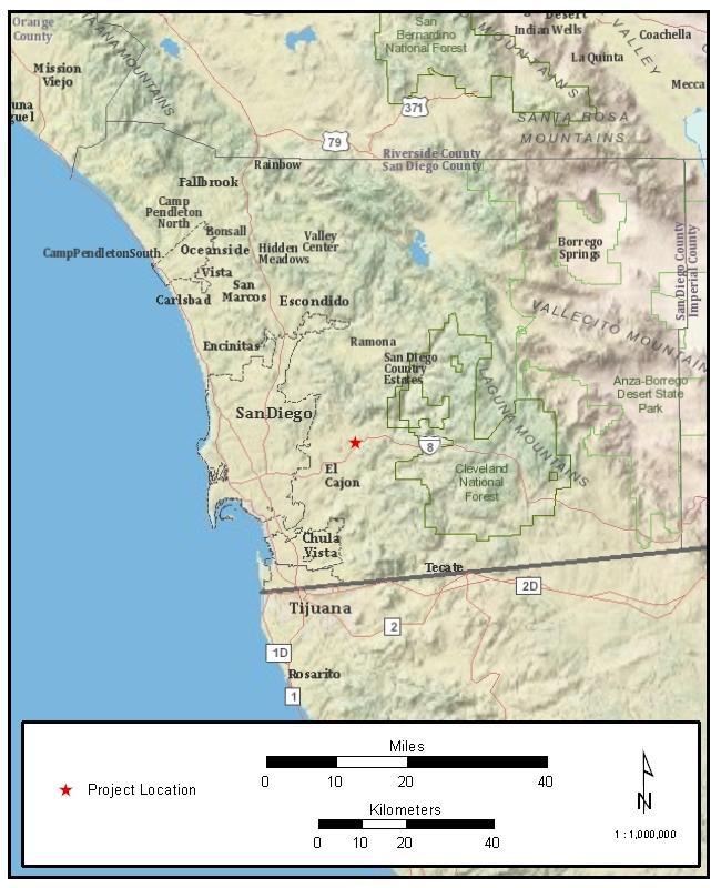
, for Padre Dam Municipal Water District's (District) Eastern Service Area Secondary Connection-Alternative Site Location, San Diego County, California (Figure 1).")
1 Mark Niemiec Padre Dam Municipal Water District P.O. Box Fanita Parkway Santee, California Re: Additional Testing for Padre Dam Eastern Service Area Secondary Connection- Alternative Site Location, San Diego County, California Dear, This letter report documents the results of an archaeological investigation conducted by ASM Affiliates, Inc. (ASM), for Padre Dam Municipal Water District's (District) Eastern Service Area Secondary Connection-Alternative Site Location, San Diego County, California (Figure 1). The purpose of this cultural assessment was to determine the absence or presence of subsurface cultural constituents within the proposed project area through shovel test pits (STPs). To date, two phases of work were conducted within the area of potential effects (APE). During the first phase (see memo dated April 25, 2012), a total of nine recorded prehistoric isolates and two prehistoric bedrock milling sites were identified within the APE. Adam Giacinto, ASM Archaeologist, directed a crew of three archaeologists, and Dr. Micah Hale (formally ASM) provided oversight. The project area was subsequently revisited and tested a second time by Associate Archaeologist Angela Pham with Assistant Archaeologist Thomas Taylor on June 22, 2012 under the supervision of Dr. Mark Becker. Description of Activity The District is proposing the construction of a pump station, reservoir, and flow control facility in the unincorporated community of Lakeside (Figure 2). The address for the proposed project area is Olde Highway 80 (Highway 8 Business Loop). The area is within an unsectioned portion of El Cajon land grant of Township 15 South and Range 1 East on the U.S. Geological Survey (USGS) 7.5-minute El Cajon quadrangle. Los Coches Creek runs through the proposed project area, east-to-west (Figure 3). The environment is primarily comprised of imported, nonnative and native grasses, and ornamental plants and trees, with southern willow scrub vegetation along a portion of Los Coches Creek and several oak trees scattered throughout the parcel. The proposed project is located on a parcel (APN ) totaling approximately 4.4 acres.
2 Page 2 On June 21, 2012, the District requested that ASM conduct further investigation of the proposed project area. The subsequent testing occurred on June 22, 2012 and consisted of eleven STPs located on the southern most end of the proposed project area. Frank Brown, Native American representative for the Viejas Band of the Kumeyaay, was present during the archaeological testing. Results of Shovel Test Pits During this second subsurface phase of cultural investigations, eleven additional STPs (STP-11 to STP-21) were excavated (Figure 4). These STPs were located on the southern part of the proposed project area where the reservoir and pump station may be located. The STPs measured 0.25 m north/south x 0.5 m east/west. STPs were excavated in 20-cm levels. All but one STP was excavated to a depth of 40 cm due to the absence of cultural material. Due to its close proximity to a boulder outcrop, STP-17 continued down to a depth of 60 cm. STP-17 did not yield cultural material. In summary, all eleven of the STPs excavated on the most recent investigation of the project area were negative. The side-wall profiles from all STPs exhibited limited-to-severe mixing of subsurface and surface soils through bioturbation and modern activities. Native American Concerns and Observations The Native American representatives have expressed concern regarding the limited visibility of the ground surface throughout the project area. Conclusions Intensive pedestrian survey and subsurface testing conducted by ASM suggests that there is a sparse distribution of cultural material throughout much of the proposed project parcel. A total of two bedrock milling features, one portable millingstone, five lithic flakes, 32.4 g of imported marine shell, and 8.7 g of avian bone were recorded on the surface and through subsurface testing. All areas within the parcel have been subjected to natural and modern disturbances. Testing indicates that no significant subsurface cultural deposits are present, and that there is a high level of disturbance both on and below the surface. Based on this testing program, the sparse distribution of cultural material and lack of significant subsurface cultural deposits, the archaeological site within the current proposed project parcel has low data potential and does not appear to meet the significance criteria defined within the California Environmental Quality Act (CEQA) and San Diego County Resource Protection Ordinance (RPO). If extensive ground disturbance will occur within this project parcel, archaeological monitoring is recommended, along with careful movement of the first two feet of soils through controlled grading to ensure the proper treatment of any unanticipated discoveries of cultural deposits. It
3 Page 3 is also recommended that a monitoring and unanticipated discoveries treatment plan be prepared prior to any project construction at the current project parcel. A Native American observer should also be present during further project work at this site. If you have any questions regarding this report, please do not hesitate to contact me. Sincerely, Mark S. Becker, Ph.D., RPA Project Manager CC: Angela Pham, M.A., RPA References Laylander, Don and Dave Iversen 2006 SDI-4553, Major Shellfish Genera and Prehistoric Change on the San Diego County Coast. In PCAS Quarterly, 39 (4): Attachments: Figure 1. Regional overview of project location Figure 2. Location Map: El Cajon, CA USGS quad: T 15 S, R 1 E Figure 3. Study Area; Old Highway 80 project parcel Figure 4. Map of all excavation locations. Note that STPs were conducted for the second phase of subsurface investigations


4 Page 4

5 Page 5 Figure 2. Location Map: El Cajon, CA USGS quad: T 15 S, R 1 E

6 Page 6 Figure 3. Study Area; Olde Highway 80 project parcel

7 Page 7 Figure 4. Map of all excavation locations. Note that STPs were conducted for the second phase of subsurface investigations.
Archaeological Survey and Evaluation at 8954 El Dorado Parkway, El Cajon, San Diego County, California
 April 16, 2013 Ms. Andrea Bitterling Helix Environmental Planning, Inc. 7578 El Cajon Blvd., Suite 200 El Cajon, California 91942 Re: Archaeological Survey and Evaluation at 8954 El Dorado Parkway, El
April 15, Ms. Andrea Bitterling Helix Environmental Planning, Inc El Cajon Boulevard La Mesa, CA 91942
 Ms. Andrea Bitterling Helix Environmental Planning, Inc. 7578 El Cajon Boulevard La Mesa, CA 91942 RE: Archaeological Investigation for the Discharge Pipeline of the Padre Dam Eastern Service Area Secondary
PW Parkway ES Prince William County, Virginia WSSI #
 PW Parkway ES Prince William County, Virginia WSSI #15.3 Cultural Resources Site Assessment November 15 Prepared for: Prince William County Public Schools P.O. Box 39 Manassas, Virginia 1 Prepared by:
Advanced Geologic Exploration, Inc.
 Advanced Geologic Exploration, Inc. Scientists of the Earth PO Box 1956, Chester, CA 96020 Voice: (530) 258-4228 Fax (530) 258-4339 www.advancedgeologic.com January 23, 2009 Job No. G-081201 Terri Barber,
AN ARCHAEOLOGICAL SURVEY FOR THE DCP MIDSTREAM THREE RIVERS PLANT TO CGP 51 PROJECT IN LIVE OAK COUNTY, TEXAS
 AN ARCHAEOLOGICAL SURVEY FOR THE DCP MIDSTREAM THREE RIVERS PLANT TO CGP 51 PROJECT IN LIVE OAK COUNTY, TEXAS By William E. Moore Brazos Valley Research Associates Contract Report Number 251 2011 AN ARCHAEOLOGICAL
December 13, Kirk Shields Green Mountain Power 163 Acorn Lane Colchester, VT 05446
 December 13, 2017 Kirk Shields Green Mountain Power 163 Acorn Lane Colchester, VT 05446 RE: End of Field Letter for Archaeological Phase II Site Evaluation at Site VT-CH-1218 within the Proposed Milton
David Moore, PacifiCorp Cultural Resources Coordinator Denise DeJoseph, Project Archaeologist
 References DeJoseph, Denise 2011 Lewis River HPMP: Swift Camp FSC Survey Negative Results. Memo report submitted by Historical Research Associates to PacifiCorp, Portland, Oregon. Copies available at PacifiCorp,
4.11 CULTURAL RESOURCES
 4.11 CULTURAL RESOURCES 4.11 CULTURAL RESOURCES This section summarizes the cultural resources of. Information reviewed for the summary includes the General Plan, published reports on archaeological research
AN ARCHAEOLOGICAL SURVEY FOR THE EASTHAM STATE PRISON FARM UNIT PROJECT IN HOUSTON COUNTY TEXAS
 AN ARCHAEOLOGICAL SURVEY FOR THE EASTHAM STATE PRISON FARM UNIT PROJECT IN HOUSTON COUNTY TEXAS Antiquities Permit 5693 By William E. Moore and Edward P. Baxter Brazos Valley Research Associates Contract
Sacred Lands File & Native American Contacts List Request
 Sacred Lands File & Native American Contacts List Request NATIVE AMERICAN HERITAGE COMMISSION 915 Capitol Mall, RM 364 Sacramento, CA 95814 (916) 653-4082 (916) 657-5390 Fax nahc@pacbell.net Information
SUMMARY OF SOIL CONDITIONS CITYWIDE SIDEWALK IMPROVEMENT PROJECT JIMMY DURANTE BOULEVARD, VIA DE LA VALLE, AND CAMINO DEL MAR DEL MAR, CALIFORNIA
 SUMMARY OF SOIL CONDITIONS CITYWIDE SIDEWALK IMPROVEMENT PROJECT JIMMY DURANTE BOULEVARD, VIA DE LA VALLE, AND CAMINO DEL MAR DEL MAR, CALIFORNIA PREPARED FOR NASLAND ENGINEERING SAN DIEGO, CALIFORNIA
Appendix I-1: Archaeological Records Search
 Appendix I-1: Archaeological Records Search South Central Coastal Information Center California State University, Fullerton Department of Anthropology MH-426 800 North State College Boulevard Fullerton,
4.3 CULTURAL RESOURCES
 4.3 CULTURAL RESOURCES This section of the EIR analyzes the proposed project s potential impacts on archaeological and paleontological resources. This analysis summarizes the findings of the Archaeological
COLORADO CULTURAL RESOURCE SURVEY Management Data Form Rev. 11/10
 COLORADO CULTURAL RESOURCE SURVEY OAHP1400 Rev. 11/10 A should be completed for each cultural resource recorded during an archaeological survey. Isolated finds and revisits are the exception and they do
STRUCTURAL STABILITY ASSESSMENT
 STRUCTURAL STABILITY ASSESSMENT CFR 257.73(d) Bottom Ash Pond Complex Cardinal Plant Brilliant, Ohio October, 2016 Prepared for: Cardinal Operating Company Cardinal Plant Brilliant, Ohio Prepared by: Geotechnical
Hydrogeological Assessment for Part of Lots 2 and 3, Concession 5, Township of Thurlow, County of Hastings 1.0 INTRODUCTION. 1.
 February 10,2017 25506400 Ontario Ltd. Foxboro, ON Attention: Brad Newbatt Re: Hydrogeological Assessment for Part of Lots 2 and 3, Concession 5, Township of Thurlow, County of Hastings 1.0 INTRODUCTION
404 Nationwide Permit: File No. SPL PKK FWS-LA-14B F0556 Streambed Alteration Agreement Notification No.
 HELIX Environmental Planning, Inc. 7578 El Cajon Boulevard La Mesa, CA 91942 619.462.1515 tel 619.462.0552 fax www.helixepi.com July 17, 2017 Ms. Colleen Draguesku Carlsbad Fish and Wildlife Office 2177
County of San Diego, Planning & Development Services
 County of San Diego, Planning & Development Services E N V I R O N M E N T A L R E V I E W U P D A T E A P P L I C A T I O N F O R A P P L I C A T I O N S C O V E R E D B Y A P R E V I O U S L Y C O M
RE: End of Field Letter for the Proposed Milton Mears Farm Road Solar Project, Milton, Chittenden County, Vermont
 October 10, 2017 Kirk Shields Green Mountain Power 163 Acorn Lane Colchester, VT 05446 RE: End of Field Letter for the Proposed Milton Mears Farm Road Solar Project, Milton, Chittenden County, Vermont
FRIENDS OF THE EEL RIVER
 FRIENDS OF THE EEL RIVER Working for the recovery of our Wild & Scenic River, its fisheries and communities. Frank Blackett, Regional Engineer Office of Energy Projects Division of Dam Safety and Inspections
Cultural Resources Data
 MENIFEE VALLEY CAMPUS MASTER PLAN DRAFT EIR MT. SAN JACINTO COMMUNITY COLLEGE DISTRICT Appendices Appendix E Cultural Resources Data February 2017 MENIFEE VALLEY CAMPUS MASTER PLAN DRAFT EIR MT. SAN JACINTO
Archaeological Survey and Assessment of Four Wastewater Interceptor Routes in Garner, Wake Co., N.C. (EPA C )
") Archaeological Survey and Assessment of Four Wastewater Interceptor Routes in Garner, Wake Co., N.C. (EPA C370623-02) By H. Trawick \vard R. P. Stephen Davis Prepared by the Research Laboratories of Anthropology
Archaeological Survey and Assessment of Four Wastewater Interceptor Routes in Garner, Wake Co., N.C. (EPA C370623-02) By H. Trawick \vard R. P. Stephen Davis Prepared by the Research Laboratories of Anthropology
New Mexico Register / Volume XVI, Number 15 / August 15, 2005
 TITLE 4 CHAPTER 10 PART 17 CULTURAL RESOURCES CULTURAL PROPERTIES AND HISTORIC PRESERVATION STANDARDS FOR MONITORING 4.10.17.1 ISSUING AGENCY: Cultural Properties Review Committee. Contact State Historic
Appendix 7A. Cultural Resources Documentation
 Appendix 7A Cultural Resources Documentation October 5, 2009 Mr. Douglas P. Mackey Historic Preservation Program Analyst, Archaeology New York State Office of Parks, Recreation and Historic Preservation
1.0 PURPOSE AND FORMAT OF THE FINAL EIR
 1.0 PURPOSE AND FORMAT OF THE FINAL EIR 1.1 PROJECT OVERVIEW CEMEX (RMC Pacific Materials, dba CEMEX) operates the Bonny Doon Shale and Limestone Quarries in Santa Cruz County for the production of Portland
The following maps must be provided as a part of the ADA. The appropriate scale for each map should be determined at the pre application conference.
 Main Street @ Coconut Creek DRI QUESTION 9 MAPS The following maps must be provided as a part of the ADA. The appropriate scale for each map should be determined at the pre application conference. Map
Project Background. March 9, Commissioners of Public Works 103 Saint Phillip Street Charleston, South Carolina 29203
 March 9, 2016 Commissioners of Public Works 103 Saint Phillip Street Charleston, South Carolina 29203 Attention: Reference: Mr. Frank Crawford Historic and Archaeological Properties Survey Dear Mr. Crawford:
Template for Sediment and Erosion Control Plan General Instructions. Section Instructions
 Template for Sediment and Erosion Control Plan General Instructions Introduction: Soil erosion and sediment deposition from farmlands can contribute to degraded surface water quality. Sediment delivery
CHAPTER 4. Blue Heron Site (47Je1001) 2003 Investigations. By Chrisie L. Hunter
 2003 Investigations. By Chrisie L. Hunter") CHAPTER 4 Blue Heron Site (47Je1001) 2003 Investigations By Chrisie L. Hunter Introduction The Blue Heron site (47Je1001) is on the property of the Crescent Bay Hunt Club, which is located in the NE 1/4
CHAPTER 4 Blue Heron Site (47Je1001) 2003 Investigations By Chrisie L. Hunter Introduction The Blue Heron site (47Je1001) is on the property of the Crescent Bay Hunt Club, which is located in the NE 1/4
NORTHWEST MENARD COUNTY, TEXAS Prepared for the City of Menard
 ... NATU AAtGAS PIPELINE SURVEY NORTHWEST MENARD COUNTY, TEXAS Prepared for the City of Menard Thomas C. Kelly and Fred Valdez, Jr. Center for Archaeological Research The University of Texas at San Antonio
Shoreline and Climate Change Adaptation Alternatives for The Letter Parcel, Bolinas Lagoon
 Shoreline and Climate Change Adaptation Alternatives for The Letter Parcel, Bolinas Lagoon Scenic shoreline vista of Bolinas Lagoon and ridges, from Letter Parcel, March 2016 Peter Baye, Coastal Ecologist
APPROVED JURISDICTIONAL DETERMINATION FORM U.S. Army Corps of Engineers
 APPROVED JURISDICTIONAL DETERMINATION FORM U.S. Army Corps of Engineers This form should be completed by following the instructions provided in Section IV of the JD Form Instructional Guidebook. SECTION
GEOSYNTEC CONSULTANTS
 GEOSYNTEC CONSULTANTS 2100 Main Street, Suite 150 Huntington Beach, CA 92648 USA Tel (714) 969-0800 Fax (714) 969-0820 15 February 2006 Ms. Tamara Zeier, P.E. Project Manager Project Navigator, Ltd. One
patersongroup Consulting Engineers April 20, 2010 File: PG1887-LET.01R Novatech Engineering Consultants Suite 200, 240 Michael Cowpland Drive
 patersongroup April 20, 2010 File: PG1887-LET.01R Novatech Engineering Consultants Suite 200, 240 Michael Cowpland Drive Ottawa, Ontario K2M 1P6 Attention: Mr. Adam Thompson Consulting Engineers 28 Concourse
THE CROOKS GAP HOUSEPIT SITE AND OTHER NEARBY MID-HOLOCENE HOUSEPITS
 Volume 56(1 ), Spring 2012 The Wyoming Archaeologist THE CROOKS GAP HOUSEPIT SITE AND OTHER NEARBY MID-HOLOCENE HOUSEPITS by Craig S. Smith Marcia Peterson INTRODUCTION This article summarizes excavation
IV. ENVIRONMENTAL IMPACT ANALYSIS E. GEOLOGY AND SOILS
 IV. ENVIRONMENTAL IMPACT ANALYSIS E. GEOLOGY AND SOILS The following section is a summary of the geotechnical report conducted for the Proposed Project. The Geotechnical Engineering Investigation (the
Guidance for implementing the Potential Fossil Yield Classification (PFYC) System
 System") Guidance for implementing the Potential Fossil Yield Classification (PFYC) System Introduction The PFYC system will aid in assessing the potential to discover or impact significant paleontological resources.
Guidance for implementing the Potential Fossil Yield Classification (PFYC) System Introduction The PFYC system will aid in assessing the potential to discover or impact significant paleontological resources.
Slope Stability Evaluation Ground Anchor Construction Area White Point Landslide San Pedro District Los Angeles, California.
 Slope Stability Evaluation Ground Anchor Construction Area White Point Landslide San Pedro District Los Angeles, California Submitted To: Mr. Gene Edwards City of Los Angeles Department of Public Works
COUNTY OF SONOMA PERMIT AND RESOURCE MANAGEMENT DEPARTMENT 2550 Ventura Avenue, Santa Rosa, CA (707) FAX (707)
 FAX (707)") COUNTY OF SONOMA PERMIT AND RESOURCE MANAGEMENT DEPARTMENT 2550 Ventura Avenue, Santa Rosa, CA 95403 (707) 565-1900 FAX (707) 565-1103 DATE : TO: FROM: SUBJECT: July 21, 2009 at 2:30 p.m. Board of Supervisors
COUNTY OF SONOMA PERMIT AND RESOURCE MANAGEMENT DEPARTMENT 2550 Ventura Avenue, Santa Rosa, CA 95403 (707) 565-1900 FAX (707) 565-1103 DATE : TO: FROM: SUBJECT: July 21, 2009 at 2:30 p.m. Board of Supervisors
CA Historical Resources Inventory Listing
 Appendix F Cultural CA Historical Resources Inventory Listing City Street Address Status Eval Date Resource Name Build Date Zip County APN Prop Number Prog Ref Number Primary Number OHP Program Code Van
Converse Consultants Geotechnical Engineering, Environmental & Groundwater Science, Inspection & Testing Services
 Converse Consultants Geotechnical Engineering, Environmental & Groundwater Science, Inspection & Testing Services July 27, 2017 Ms. Rebecca Mitchell Mt. San Antonio College Facilities Planning & Management
Appendix D-2. Paleo Letter
 Appendix D-2 Paleo Letter June 12, 2015 Scott Dinovitz Glassell Park, LLC 23622 Calabasas Rd, Ste 220 Calabasas, CA, 91302 Cc: Nancy Johns, Wildflower Development SUBJECT: Paleontological Resources Letter
Converse Consultants Geotechnical Engineering, Environmental & Groundwater Science, Inspection & Testing Services
 Converse Consultants Geotechnical Engineering, Environmental & Groundwater Science, Inspection & Testing Services Ms. Rebecca Mitchell Mt. San Antonio College Facilities Planning & Management 1100 North
Big Rivers Electric Corporation Disposal of Coal Combustion Residuals (CCR) from Electric Utilities Final Rule CCR Impoundment Liner Assessment Report
 from Electric Utilities Final Rule CCR Impoundment Liner Assessment Report") Big Rivers Electric Corporation Disposal of Coal Combustion Residuals (CCR) from Electric Utilities Final Rule CCR Impoundment Liner Assessment Report CCR Surface Impoundment Information Name: Operator:
Big Rivers Electric Corporation Disposal of Coal Combustion Residuals (CCR) from Electric Utilities Final Rule CCR Impoundment Liner Assessment Report CCR Surface Impoundment Information Name: Operator:
MEMORANDUM. Jerry Conrow, Ojai Basin Groundwater Management Agency
 MEMORANDUM TO: FROM: Jerry Conrow, Ojai Basin Groundwater Management Agency Gregory Schnaar, PhD, Stephen J. Cullen, PhD, PG, DATE: August 6, 2014, 2014 SUBJECT: Ojai Basin Groundwater Model - Extended
Preliminary Geotechnical Evaluation Gooseberry Point Pedestrian Improvements Whatcom County, Washington SITE AND PROJECT DESCRIPTION
 File No. 12-100 Geotechnical & Earthquake Engineering Consultants Mr. Kevin Brown, P.E. Gray & Osborne, Inc. 3710 168 th Street NE, Suite B210 Arlington, Washington 98223 Subject: Draft Report Preliminary
RE: AFIN: ADEQ Reference #: WG-LA Well Site: Suarez-Gartner 8-12 No. 1-30H
 November 2, 2017 Rick Spicer Regulatory & Environmental Superintendent Operations BHP Billiton Petroleum, LLC Fayetteville Petroleum Unit 1686 Letona Rd Searcy, AR 72143 RE: AFIN: 23-00000 ADEQ Reference
IMPERIAL COUNTY PLANNING AND DEVELOPMENT
 IMPERIAL COUNTY PLANNING AND DEVELOPMENT GEODATABASE USER MANUAL FOR COUNTY BUSINESS DEVELOPMENT GIS June 2010 Prepared for: Prepared by: County of Imperial Planning and Development 801 Main Street El
December 16, Mr. Lee Hughes Southwest Florida Water Management District Tampa Service Office 7601 Highway 301 North Tampa, FL 33637
 December 16, 2015 Mr. Lee Hughes Southwest Florida Water Management District Tampa Service Office 7601 Highway 301 North Tampa, FL 33637 RE: Response to SWFWMD Supplemental Information Request Dear Mr.
Great California Delta Trail Blueprint for Contra Costa and Solano Counties GIS AND MAPPING MEMORANDUM JULY 2010
 Great California Delta Trail Blueprint for Contra Costa and Solano Counties GIS AND MAPPING MEMORANDUM JULY 2010 {DRAFT} July 2010 Introduction Geographic Information Systems (GIS) are computer-based
Lab Topographic Maps. Name: Partner: Purpose. Background Information
 Lab Topographic Maps Name: Partner: Purpose The purpose of this lab is to familiarize you with graphic representations of the Earth s surface primarily maps. Simple line maps show the spatial relationship
Template for Sediment and Erosion Control Plan General Instructions
 Template for Sediment and Erosion Control Plan General Instructions Introduction: Soil erosion and sediment deposition from farmlands can contribute to degraded surface water quality. Sediment delivery
County of Santa Cruz
 County of Santa Cruz BOARD OF SUPERVISORS 701 OCEAN STREET, SUITE 500, SANTA CRUZ, CA 95060-4069 (831) 454-2200 FAX: (831) 454-3262 TDD: (831) 454-2123 JANET K. BEAUT2 ELLEN PlRlE NEAL COONERTY TONY CAMPOS
Table 9. FAI accession log
 Table 9. FAI-02045 accession log UA Accession # FS # Depth (cm BS) Artifact Type n= Material Color UA2010-187-0001 1 5-10 utilized flake 1 basalt black UA2010-187-0002 2 5-10 flake 1 chert black UA2010-187-0003
Villages at Riverdale Thornton, CO
 FINAL UTILITY REPORT Villages at Riverdale Thornton, CO October 14, 216 Revised: March 29, 217 JN: 1539 Prepared for: PCS Group, Inc. 11 16 th Street #3 B-18 Denver, CO 8265 P: 33.531.495 Prepared by:
Archaeological Reconnaissance Survey of. Boundary, North Kona, Island of Hawai i (TMK:7 2 04:05)
") T. S. Dye & Colleagues, Archaeologists, Inc. 735 Bishop St., Suite 315, Honolulu, Hawai i 96813 Archaeological Reconnaissance Survey of Proposed Project Area on Kūki o 1st-Kūki o 2nd Boundary, North Kona,
T. S. Dye & Colleagues, Archaeologists, Inc. 735 Bishop St., Suite 315, Honolulu, Hawai i 96813 Archaeological Reconnaissance Survey of Proposed Project Area on Kūki o 1st-Kūki o 2nd Boundary, North Kona,
Remote Sensing and Geographic Information System (GIS) Based Analysis of Historic Resources
 Based Analysis of Historic Resources") World War II Additional Material Remote Sensing and Geographic Information System (GIS) Based Analysis of Historic Resources By Nicole Vernon and Patrick O Day, GANDA Remote Sensing and Geographic Information
World War II Additional Material Remote Sensing and Geographic Information System (GIS) Based Analysis of Historic Resources By Nicole Vernon and Patrick O Day, GANDA Remote Sensing and Geographic Information
Report on Geophysical Survey Na Vrsku, Sahy, Slovakia Coordinates: 48⁰,4,45 N 18⁰,56,23 E. April 2018
 Report on Geophysical Survey Na Vrsku, Sahy, Slovakia Coordinates: 48⁰,4,45 N 18⁰,56,23 E April 2018 Mark Graham BA(Hons), BSc, MA Grampus Heritage and Training Ltd, Ashgill, Threapland, Wigton, Cumbria,
SAN FRANCISCO DISTRICT INFORMATION REQUESTED FOR VERIFICATION OF CORPS JURISDICTION
 DEPARTMENT OF THE ARMY SAN FRANCISCO DISTRICT, U.S. ARMY CORPS OF ENGINEERS 1455 MARKET STREET SAN FRANCISCO, CALIFORNIA 94103-1398 SAN FRANCISCO DISTRICT INFORMATION REQUESTED FOR VERIFICATION OF CORPS
Exhibit RMP-4. Foote Creek Geology and Topography
 Exhibit RMP-4 Foote Creek Geology and Topography Memorandum To: From: CC: Travis Brown, PacifiCorp Daria Drago, P.E., PMP Dr. Deb Luchsinger Date: January 9, 2019 Re: Foote Creek Rim 1 - Geologic Conditions
Geospatial Data Model for Archaeology Site Data
 Authors: David T. Hansen, Barbara D. Simpson, Anastasia Leigh, Patrick Welch, and Lorri Peltz-Lewis Geospatial Data Model for Archaeology Site Data Presented by David T. Hansen and Barbara D. Simpson at
Rock Scaling Recommendations Logan Creek Drive Cut Slope
 Rock Scaling Recommendations Logan Creek Drive Cut Slope US 50, Milepost DO 8.47 to DO 8.61 Douglas County, Nevada January 2008 MATERIALS DIVISION STATE OF NEVADA DEPARTMENT OF TRANSPORTATION MATERIALS
Coyote Creek Apache County, Arizona
 Coyote Creek Apache County, Arizona Listed for sale exclusively by: Traegen Knight Headquarters West Ltd. PO BOX 1980 St. Johns, AZ 85936 Phone: (928) 524-3740, Fax: (928) 563-7004, Cell: (602) 228-3494
Report for Area Drainage Studies for 1320 MW (2x660 MW) THERMAL POWER PROJECT AT MIRZAPUR, U.P.
 THERMAL POWER PROJECT AT MIRZAPUR, U.P.") Report for Area Drainage Studies for 1320 MW (2x660 MW) THERMAL POWER PROJECT AT MIRZAPUR, U.P. 1. Introduction M/s Welspun Energy Uttar Pradesh Ltd. (WEUPL) is putting up 1320 MW (2 x 660 MW) coal fired
Report for Area Drainage Studies for 1320 MW (2x660 MW) THERMAL POWER PROJECT AT MIRZAPUR, U.P. 1. Introduction M/s Welspun Energy Uttar Pradesh Ltd. (WEUPL) is putting up 1320 MW (2 x 660 MW) coal fired
THE WILDLIFE SOCIETY CONFERENCE 2015
 THE WILDLIFE SOCIETY CONFERENCE 2015 Evaluation of Desert Tortoise Habitat Suitability Model Predictions in the Soda Mountain Area, San Bernardino County Susanne Heim Introduction Overview of Species Habitat
ENGINEERING EVALUATION OF THE STANLEY MINE ADVENTURE PARK AREA CLEAR CREEK COUNTY, COLORADO. Prepared for:
 braun Braun Consulting Engineers ENGINEERING EVALUATION OF THE STANLEY MINE ADVENTURE PARK AREA CLEAR CREEK COUNTY, COLORADO Prepared for: STANLEY MINES ADENTURE PARK 3375 W. POWERS CIRCLE LITTLETON, COLORADO
EXHIBIT H LOT 317 GRADING AND SITE PLAN
 EXHIBIT H LOT 317 GRADING AND SITE PLAN EXHIBIT I LOT 317 ELEVATIONS ridge height 4915'-6" GENERAL & KEYED NOTES ridge height 4905'-9" 3 7 4 A5.1 1 5 ridge height 4910'-6" 2 ridge height 4906'-3" 1 Provide
16 January 2018 Job Number: RICHARD NEWMAN C\- CLARK FORTUNE MCDONALD AND ASSOCIATES PO BOX 553 QUEENSTOWN
 16 January 2018 Job Number: 50595 RICHARD NEWMAN C\- CLARK FORTUNE MCDONALD AND ASSOCIATES PO BOX 553 QUEENSTOWN CHANSEN@CFMA.CO.NZ STORMWATER DISPOSAL ASSESSMENT Dear Richard, RDAgritech were requested
PHIMF Project - Limited Geotechnical Investigation - Feasibility-Level Report RESPONSE TO INITIAL REVIEW LETTER
 Connie Christian, P.E. County Sanitation Districts of Los Angeles County 1955 Workman Mill Road Whittier, California 90601 Project No. BAS 04-02E January 29, 2008 Subject: PHIMF Project - Limited Geotechnical
APPENDIX D. Paleontological Resources Report
 APPENDIX D Paleontological Resources Report MEMORANDUM To: From: Joanne M. Dramko, AICP, GISP, Senior Environmental Manager, PBS&J/ΛTKINS George J. Burwasser, California Registered Geologist 7151, PBS&J/ΛTKINS
MAPPING BEDROCK: Verifying Depth to Bedrock in Calumet County using Seismic Refraction
 MAPPING BEDROCK: Verifying Depth to Bedrock in Calumet County using Seismic Refraction Revised December 13, 2011 Dave Hart Wisconsin Geological and Natural History Survey INTRODUCTION Seismic refraction
4.12 Mineral Resources
 4.12.1 Setting Section 2.2, Project Location, provides general information about the Project s regional and local setting. This Section 4.12.1 provides setting information specific to mineral resources.
FINAL PROJECT PLAN TAX INCREMENT DISTRICT #66 MORNINGSTAR. Prepared by the
 PROJECT PLAN TAX INCREMENT DISTRICT #66 MORNINGSTAR Prepared by the Rapid City Growth Management Department January 17, 2008 INTRODUCTION Tax Increment Financing is a method of financing improvements and
PLANNING COMMISSION AGENDA
 COUNTY OF IMPERIAL COMMISSIONERS: Chairman: Rudy Schaffner Dennis Bergh Norm Niver Vice Chairman: Carson Kalin Sergio Cabanas Russell Roben Max Castillo Carlton A. Hargrave Ernesto Medina JIM MINNICK,
3.12 Paleontological Resources
 3.12 This section evaluates the potential impacts of the Proposed Action on paleontological resources. This evaluation includes an assessment of the direct and cumulative effects of the Proposed Action
ENGINEER S CERTIFICATION OF FAULT AREA DEMONSTRATION (40 CFR )
") PLATTE RIVER POWER AUTHORITY RAWHIDE ENERGY STATION BOTTOM ASH TRANSFER (BAT) IMPOUNDMENTS LARIMER COUNTY, CO ENGINEER S CERTIFICATION OF FAULT AREA DEMONSTRATION (40 CFR 257.62) FOR COAL COMBUSTION RESIDUALS
PLATTE RIVER POWER AUTHORITY RAWHIDE ENERGY STATION BOTTOM ASH TRANSFER (BAT) IMPOUNDMENTS LARIMER COUNTY, CO ENGINEER S CERTIFICATION OF FAULT AREA DEMONSTRATION (40 CFR 257.62) FOR COAL COMBUSTION RESIDUALS
Archaeological Report Guidelines
 Archaeological Report Guidelines Archaeological reports for different stages of project development should adequately reflect the level of investigation completed. The following format outline is intended
Allen Reservoir Failure Analysis Docs
 Allen Reservoir Failure Analysis Docs Don Lancaster Synergetics, Box 809, Thatcher, AZ 85552 copyright c2010 pub 10/10 as GuruGram #113 http://www.tinaja.com don@tinaja.com (928) 428-4073 There is a spectacularly
1.0 INSPECTION ANNUAL INSPECTION, JUNE 29, 2011 CARMACKS COPPER PROJECT, CARMACKS, YUKON. Dear Mr. West-Sells,
 Doc. No. 162 Rev. 0 Mr. Paul West-Sells President & Chief Operating Officer Western Copper Corporation 2060-1111 West Georgia Street Vancouver, BC V6E 4M3 ANNUAL INSPECTION, JUNE 29, 2011 CARMACKS COPPER
New Research Exploring the Origins of Sanxingdui
 New Research Exploring the Origins of Sanxingdui The Harvard community has made this article openly available. Please share how this access benefits you. Your story matters. Citation Published Version
NEEDLES S STREET LEVEE SYSTEM SAN BERNARDINO COUNTY, CALIFORNIA NLD SYSTEM ID #
 SAN BERNARDINO COUNTY, CALIFORNIA NLD SYSTEM ID # 3805030008 PERIODIC INSPECTION REPORT NO. 1 GENERALIZED EXECUTIVE SUMMARY FINAL SYSTEM RATING: MINIMALLY ACCEPTABLE FINAL RATING DATE: AUGUST 2014 PERIODIC
Dolores Public Lands Office Highway 184 Dolores, CO Ph (970) Fax (970)
 Fax (970)") USDA Forest Service San Juan National Forest Mancos/Dolores Ranger District http://www.fs.fed.us/r2/sanjuan Dolores Public Lands Office 29211 Highway 184 Dolores, CO 81323 Ph (970) 882-7296 Fax (970) 882-6841
USDA Forest Service San Juan National Forest Mancos/Dolores Ranger District http://www.fs.fed.us/r2/sanjuan Dolores Public Lands Office 29211 Highway 184 Dolores, CO 81323 Ph (970) 882-7296 Fax (970) 882-6841
CASE STUDY #9 - Brushy Fork Dam, Sugar Grove, West Virginia
 CASE STUDY #9 - Brushy Fork Dam, Sugar Grove, West Virginia Brushy Fork Dam is a flood control structure built by the Soil Conservation Service southeast of the city of Franklin in Pendleton County, West
Starting at Rock Bottom: A Peculiar Central Texas PreClovis Culture
 Starting at Rock Bottom: A Peculiar Central Texas PreClovis Culture Background Brushy Creek grades, overall, west-northwest (WNW) to east-southeast (ESE) through the easternmost portions of the central
Lagunitas Creek Stewardship Plan. Marin Municipal Water District
 Lagunitas Stewardship Plan Marin Municipal Water District Final June 2011 FIGURES Lagunitas Stewardship Plan Final June 2011 Legend Tomales Bay Highway 1 Major Roads Public Lands Marin Municipal Water
J.H. Campbell Generating Facility Pond A - Location Restriction Certification Report
 J.H. Campbell Generating Facility Pond A - Location Restriction Certification Report Pursuant to: 40 CFR 257.60 40 CFR 257.61 40 CFR 257.62 40 CFR 257.63 40 CFR 257.64 Submitted to: Consumers Energy Company
REPORT OF FINDINGS FROM A PALEONTOLOGICAL RESOURCE ASSESSMENT OF ASSESSOR S PARCEL NUMBER , 013, 014 PREPARED FOR:
 REPORT OF FINDINGS FROM A PALEONTOLOGICAL RESOURCE ASSESSMENT OF ASSESSOR S PARCEL NUMBER 436-600-012, 013, 014 PREPARED FOR: BAYPOINT PREPARATORY ACADEMY c/o Mr. Bradley Burke, Steven Nelson 122 ½ S.
September 21, 2004 GeoInsight Project
 GeoInsight, Inc. GeoInsight, Inc. GeoInsight, Inc. 75 Gilcreast Road, Suite 210 319 Littleton Road, Suite 105 Corporate Ten Center Londonderry, NH 03053-3566 Westford, MA 01886 1781 Highland Avenue, Suite
DK DM M EMORANDUM D ECEMBER 28, 2018 SUBJECT:
 TO: CC: FROM: SUBJECT: BOARD OF DIRECTORS M EMORANDUM D ECEMBER 28, 2018 ANDY MUELLER, GENERAL MANAGER DAVE DK KANZER, P.E. & DON MEYER, P.E. DK DM COLORADO RIVER BASIN WATER SUPPLY CONDITIONS UPDATE AND
Work Conducted in August 2018
 Kelly Nieforth Economic Development Manager City of Oshkosh 215 Church Avenue Oshkosh, W 54903 August 31, 2018 RE: Update #9: August 1 to 31, 2018 Archaeological Data Recovery at the Golf Course Site (47WN0049)
1. PROJECT BACKGROUND. July 18, Alberta Infrastructure & Transportation Central Region #401, Street Red Deer, Alberta T4N 6K8
 July 18, 2005 Alberta Infrastructure & Transportation Central Region #401, 4902 51 Street Red Deer, Alberta T4N 6K8 Mr. Alain Momedi, P.Eng. Project Engineer Dear Mr. Momedi: H11:04 km 11.1 Erosion along
October 26, Ms. Aimee Zack Canadian Pacific 120 S. Sixth Street Suite 900 Minneapolis, Minnesota 55402
 October 26, 2017 Ms. Aimee Zack Canadian Pacific 120 S. Sixth Street Suite 900 Minneapolis, Minnesota 55402 Re: Soo Line Dump Site 2017 Annual Soil Cover Inspection Dear Aimee: The purpose of this letter
IV. Environmental Impact Analysis D.2 Cultural Resources Archaeological and Paleontological Resources
 IV. Environmental Impact Analysis D.2 Cultural Resources Archaeological and Paleontological Resources 1. Introduction The following section of the Draft EIR evaluates potential impacts related to archaeological
Report on Exploratory Drilling. Prospecting Claim Nos and
 Report on Exploratory Drilling Prospecting Claim Nos. 4212342 and 4212343 Glamorgan Township, Lot 34, Concession IV: Southern Ontario Mining Division Exploratory Drilling Program Site Work: November 11-17,2008
Should you have any questions regarding this clarification, please contact the undersigned at or (925)
") October 8, 2015 Revised October 13, 2015 Contra Costa Community College District 500 Court Street Martinez, CA 94553 Attention: Ron Johnson Subject: Clarification of Grading Requirements Diablo Valley
October 8, 2015 Revised October 13, 2015 Contra Costa Community College District 500 Court Street Martinez, CA 94553 Attention: Ron Johnson Subject: Clarification of Grading Requirements Diablo Valley
Geophysical Survey. Ballymount Co. Dublin. Licence Ref. 02R029. By John Nicholls Margaret Gowen & Co. Ltd. For LRT
 Geophysical Survey Ballymount Co. Dublin Licence Ref. 02R029 By John Nicholls Margaret Gowen & Co. Ltd. For LRT 4 th April 2002 Illustrations List of Figures Figure 1 Site Location 1: 50000 Figure 2 Survey
NOA ASSESSMENT HARRIS QUARRY MENDOCINO COUNTY, CALIFORNIA TABLE OF CONTENTS
 NOA ASSESSMENT HARRIS QUARRY MENDOCINO COUNTY, CALIFORNIA TABLE OF CONTENTS Introduction... 1 Scope of Services... 1 Project Location and Description... 1 Geologic Setting... 1 Regional Geology... 1 Site
SDI-4553, Major Shellfish Genera and Prehistoric Change on the San Diego County Coast
 SDI-4553, Major Shellfish Genera and Prehistoric Change on the San Diego County Coast Don Laylander and Dave Iversen Abstract SDI-4553 is a small Middle to Late Holocene shell midden near San Elijo Lagoon
State Laws and Regulations California Environmental Quality Act The California Environmental Quality Act (CEQA) (Chapter 1, 21002) states that:
 (Chapter 1, 21002) states that:") March 24, 2017 Rincon Project No. 16-03461 Todd A. Deutscher Catalyst Development Partners 18 Crow Canyon Court Suite 190 San Ramon, California 94593 Subject: for the, Alameda County, California Dear Mr.
March 24, 2017 Rincon Project No. 16-03461 Todd A. Deutscher Catalyst Development Partners 18 Crow Canyon Court Suite 190 San Ramon, California 94593 Subject: for the, Alameda County, California Dear Mr.
Producing Chandler Walnut Orchard
 AG-LAND Investment Brokers 275 Sale Lane Red Bluff, CA 96080 530-529-4400 Fax 530-527-5042 Producing Chandler Walnut Orchard West Sacramento Avenue - Chico, CA AG-LAND INVESTMENT BROKERS 275 Sale Lane