Spatial Analysis 1. Introduction
|
|
|
- Reginald Phillips
- 6 years ago
- Views:
Transcription
1 Spatial Analysis 1 Introduction
2 Geo-referenced Data (not any data) x, y coordinates (e.g., lat., long.) Table of Data: Obs. # x y Variables
3 Temporal vs. Spatial Data Temporal 1 dimension Units: day,week, month Lag: t-1, t-2, Durbin-Watson Spatial 2-3 dimension Units: county, mile, region Lag: near neighbor, networks, etc. Moran s I (W) Differencing Maps (distortions)
4 Ways to Study Space Map Spatial Data (GIS) Explore Properties of Geographical Space (ESDA- GIS/GEODA) Visualization techniques Spatial Modeling Spatial Statistics (Global/Local) Geostatistics Spatial Econometrics Spatial Choice / Agent Based Modeling All can be done within a GIS framework
5 Spatial Analysis Examples From a Variety of Fields Geography: Patterns of human spatial interaction, Distance decay, Segmentation of remotely sensed images, Clustering Earth Sciences: Climate, Geologic variables, Environmental issues, Water systems Ecology: Invasive species, Plant and animal regions, Fires Homeland Security: Mapped intelligence information Public Health, Epidemiology: Disease diffusion; Patterns of care; Clustering of disease; Risk factors Sociology and Demography: Behavior in space; Ethnic patterns; Spatial patterns of criminal activities; Spatial manifestation of demographic trends Political Science: Spatial patterns of voting; Redistricting; Diffusion of political movements Anthropology and Archaeology: Patterns of human activities (usually local in scale); Re-creation of past settlement patterns Economics: Spatial aspects of economic variables, Trends, Location patterns (sectors), Economic concentrations, Trade patterns History: Patterns of change, Political control, Migrations, Voyages, Ethnic conflict patterns over time Transportation: Movement, Accidents, Interaction, Flows
6 Spatial Analysis: Schools of Thought Exploratory Spatial Data Analysis (ESDA) Spatial Statistics Geostatistics Spatial Econometrics
7 ESDA GIS Functionality (buffers, distances, etc) Histograms, Box Plots, Leaf and Stem Plots Multiple Scatter Diagrams, Surfaces General Measures of Map Patterns Density, Surfaces, Clustering, Association Spatial Autocorrelation GWR Patterns of Residuals from Regression Visualization, 3-D, Fly-through Data Mining
8 Spatial Statistics Applications of Conventional Statistical Theory to Spatial Data Chance or Non-chance Occurrences in Space Measures of Spatial Association, Segregation Nearest Neighbors All Interevent Distances: K-functions Spatial Autocorrelation Statistics: I, G, c, etc. Specially Developed Tests on Spatial Randomness (or Normal) Hypotheses Clustering Spatial Filtering Spatially Dependent Tests
9 Geostatistics Distance Based Models, Continuous Surfaces Semi-variograms of different types Theoretical Empirical Kriging for Surface Extrapolation Kriging Models (Ordinary, Simple, Universal, Co-Kriging, Disjunctive) for Prediction
10 Spatial Econometrics Regression Models with One or More Spatial Parameters Development of Spatial Association Matrices Parameter Estimation and Testing Spatial Filtering Study of Model Assumptions Creation of Spatial Models
11 Software Developments New Packages Arrive Often GIS (ESRI: ARCGIS 9.1, 9.2, 9.3) Anselin s GeoDa (Free) Rey s STARS (Free) LeSage s Spatial Econometrics Tool Kit Geostatistics package (ESRI s Geospatial Analyst), GeoLib Aldstadt, Chen, and Getis PPA (Free) Jacquez ClusterSeer, for health applications Kulldorff s Scan Statistics Bivand s R Package Fotheringham, Brunsdon, and Charlton s GWR The Big Stat Packages (SPSS, SAS, S-Plus, etc.) include some spatial data manipulators.
12 Problems of Spatial Analysis Problems Help to Define the Field Scale Zoning Sizing Dependence Spatial Sampling Heterogeneity Boundaries Missing Data Large Data Sets
13 Modifiable Areal Unit Problem (MAUP): Scale Changes in scale change results How do changes in scale change results? What is the appropriate scale? Aggregation and the ecological fallacy Multi-scale analyses

14 Scale
15 MAUP: Zoning Changes in district boundaries change results. How do changes in zoning change results? The political redistricting problem Appropriate zoning Multiple zonings
16
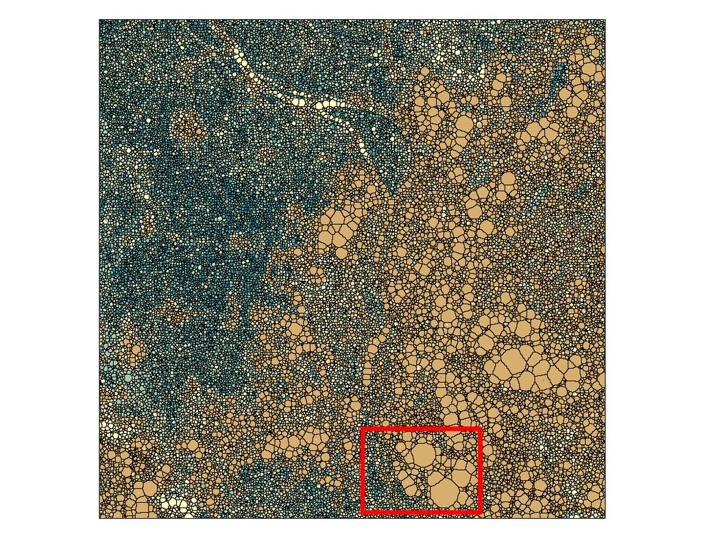
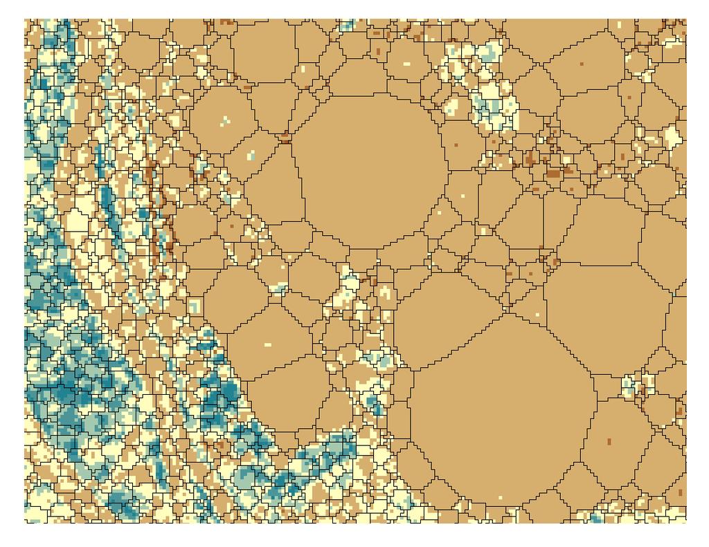
17 Sizing Problem How do we deal with heterogeneous spatial units? Spatial units of varying sizes Shape may be a problem Should each spatial unit be weighted equally?

18 Pattern of Provincial PCGDP in 1978 Source: Long Gen Ying, dissertation

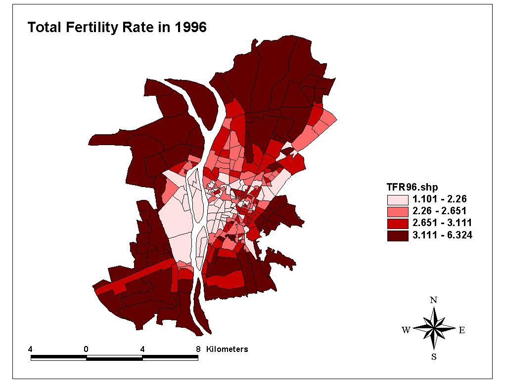
19 Pattern of Provincial PCGDP in 1994 Source: Long Gen Ying, dissertation
20 The Dependence Problem One must account for spatial dependency. Tobler s Law The problem of nearness The value of an observation problem Too many observations Spillovers/bisection Traditional statistics and independence Overcoming the problem
21
22 The Heterogeneity Problem One must make appropriate assumptions about the underlying spatial distribution. Uneven distributions at the global scale How does heterogeneity affect our results? Stationarity Drift and its effect on analysis Some suggested solutions

23 Original Data
24 The Boundaries Problem Variables and relationships are often different near boundaries. What effect do boundaries have on results? How do we take them into account? Sampling problems Awareness and care

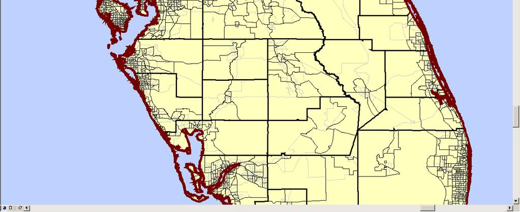
25 Boundary Problem Violent crime is a problem in the city of Wilmington, NC.
26
27 The Missing Data Problem Empty Areas do not exist Census restrictions, privacy Imputation Algorithms and common sense solutions TINs, Kriging, etc.
28
29 The Large Data Sets Problem Steps need be taken to handle large data sets. Censuses Remotely sensed data Dependence and heterogeneity Data mining, partitioning and filtering, principal components analysis
30
31
32 Solutions Associated with Spatial Pattern Analysis Scale (statistics that allow d to vary (LISA, G, K), ESDA, multiple scales) Zoning (use smallest units and then aggregate upward; use statistics that vary d; ESDA, multiple zonings) Sizing (weighting of observations) Dependence (Global, Local, Variogram, Spa. Econ.) Spatial Sampling ( independent samples) Heterogeneity (models that allow parameters to vary, GWR, Spa. Econ., partitioning) Boundaries (NN, K function) Missing Data (Kriging) Large Data Sets (nearly all of the above, partitioning)
33 Current Hot Topics in Spatial Analysis Spatial Filtering Spatial Autoregressive Modeling The W Matrix Space-Time Modeling Hierarchical Modeling, Multilevel Modeling Bayesian Geostatistics and Spatial Modeling Spatial Clustering False Discovery Rates in Spatial Tests
SPACE Workshop NSF NCGIA CSISS UCGIS SDSU. Aldstadt, Getis, Jankowski, Rey, Weeks SDSU F. Goodchild, M. Goodchild, Janelle, Rebich UCSB
 SPACE Workshop NSF NCGIA CSISS UCGIS SDSU Aldstadt, Getis, Jankowski, Rey, Weeks SDSU F. Goodchild, M. Goodchild, Janelle, Rebich UCSB August 2-8, 2004 San Diego State University Some Examples of Spatial
Temporal vs. Spatial Data
 Temporal vs. Spatial Data Temporal 1 dimensional Units: day, week, month Lag: t, t-1, t-2 Durbin-Watson Spatial 2-3 dimensional Units: county, mile, region Lag: near neighbor, networks (?) Moran s I Differencing
Exploratory Spatial Data Analysis (ESDA)
") Exploratory Spatial Data Analysis (ESDA) VANGHR s method of ESDA follows a typical geospatial framework of selecting variables, exploring spatial patterns, and regression analysis. The primary software
Exploratory Spatial Data Analysis (ESDA) VANGHR s method of ESDA follows a typical geospatial framework of selecting variables, exploring spatial patterns, and regression analysis. The primary software
Spatial Modeling, Regional Science, Arthur Getis Emeritus, San Diego State University March 1, 2016
 Spatial Modeling, Regional Science, and UCSB Arthur Getis Emeritus, San Diego State University March 1, 2016 My Link to UCSB The 1980s at UCSB (summers and sabbatical) Problems within Geography: The Quantitative
Luc Anselin Spatial Analysis Laboratory Dept. Agricultural and Consumer Economics University of Illinois, Urbana-Champaign
 GIS and Spatial Analysis Luc Anselin Spatial Analysis Laboratory Dept. Agricultural and Consumer Economics University of Illinois, Urbana-Champaign http://sal.agecon.uiuc.edu Outline GIS and Spatial Analysis
Introduction to Spatial Statistics and Modeling for Regional Analysis
 Introduction to Spatial Statistics and Modeling for Regional Analysis Dr. Xinyue Ye, Assistant Professor Center for Regional Development (Department of Commerce EDA University Center) & School of Earth,
Everything is related to everything else, but near things are more related than distant things.
 SPATIAL ANALYSIS DR. TRIS ERYANDO, MA Everything is related to everything else, but near things are more related than distant things. (attributed to Tobler) WHAT IS SPATIAL DATA? 4 main types event data,
The Case for Space in the Social Sciences
 The Case for Space in the Social Sciences Don Janelle Center for Spatially Integrated Social Science University of California, Santa Barbara Roundtable on Geographical Voices and Geographical Analysis
Spatial Data, Spatial Analysis and Spatial Data Science
 Spatial Data, Spatial Analysis and Spatial Data Science Luc Anselin http://spatial.uchicago.edu 1 spatial thinking in the social sciences spatial analysis spatial data science spatial data types and research
Using AMOEBA to Create a Spatial Weights Matrix and Identify Spatial Clusters, and a Comparison to Other Clustering Algorithms
 Using AMOEBA to Create a Spatial Weights Matrix and Identify Spatial Clusters, and a Comparison to Other Clustering Algorithms Arthur Getis* and Jared Aldstadt** *San Diego State University **SDSU/UCSB
CSISS Tools and Spatial Analysis Software
 CSISS Tools and Spatial Analysis Software June 5, 2006 Stephen A. Matthews Associate Professor of Sociology & Anthropology, Geography and Demography Director of the Geographic Information Analysis Core
Spatial Analysis 2. Spatial Autocorrelation
 Spatial Analysis 2 Spatial Autocorrelation Spatial Autocorrelation a relationship between nearby spatial units of the same variable If, for every pair of subareas i and j in the study region, the drawings
Roger S. Bivand Edzer J. Pebesma Virgilio Gömez-Rubio. Applied Spatial Data Analysis with R. 4:1 Springer
 Roger S. Bivand Edzer J. Pebesma Virgilio Gömez-Rubio Applied Spatial Data Analysis with R 4:1 Springer Contents Preface VII 1 Hello World: Introducing Spatial Data 1 1.1 Applied Spatial Data Analysis
Spatial Regression. 1. Introduction and Review. Luc Anselin. Copyright 2017 by Luc Anselin, All Rights Reserved
 Spatial Regression 1. Introduction and Review Luc Anselin http://spatial.uchicago.edu matrix algebra basics spatial econometrics - definitions pitfalls of spatial analysis spatial autocorrelation spatial
What s special about spatial data?
 What s special about spatial data? Road map Geographic Information analysis The need to develop spatial thinking Some fundamental geographic concepts (PBCS) What are the effects of space? Spatial autocorrelation
Michael Harrigan Office hours: Fridays 2:00-4:00pm Holden Hall
 Announcement New Teaching Assistant Michael Harrigan Office hours: Fridays 2:00-4:00pm Holden Hall 209 Email: michael.harrigan@ttu.edu Guofeng Cao, Texas Tech GIST4302/5302, Lecture 2: Review of Map Projection
Contents. Preface. Introduction 1 Manfred M. Fischer and Arthur Getis. GI Software Tools
 Contents Preface v Introduction 1 Manfred M. Fischer and Arthur Getis PART A GI Software Tools A.1 Spatial Statistics in ArcGIS Lauren M. Scott and Mark V. Janikas A.1.1 Introduction 27 A.1.2 Measuring
SPACE Workshop Santa Barbara, California July 2007
 SPACE Workshop Santa Barbara, California 15 20 July 2007 Modeling a Center for Spatially Integrated Social Science Critical Themes in Social Science + Tools and Concepts for Spatial Thinking + Infrastructure
GIST 4302/5302: Spatial Analysis and Modeling
 GIST 4302/5302: Spatial Analysis and Modeling Review Guofeng Cao www.gis.ttu.edu/starlab Department of Geosciences Texas Tech University guofeng.cao@ttu.edu Spring 2016 Course Outlines Spatial Point Pattern
Overview of Statistical Analysis of Spatial Data
 Overview of Statistical Analysis of Spatial Data Geog 2C Introduction to Spatial Data Analysis Phaedon C. Kyriakidis www.geog.ucsb.edu/ phaedon Department of Geography University of California Santa Barbara
Exploratory Spatial Data Analysis (And Navigating GeoDa)
") Exploratory Spatial Data Analysis (And Navigating GeoDa) June 9, 2006 Stephen A. Matthews Associate Professor of Sociology & Anthropology, Geography and Demography Director of the Geographic Information
Exploratory Spatial Data Analysis (And Navigating GeoDa) June 9, 2006 Stephen A. Matthews Associate Professor of Sociology & Anthropology, Geography and Demography Director of the Geographic Information
Lecture 5 Geostatistics
 Lecture 5 Geostatistics Lecture Outline Spatial Estimation Spatial Interpolation Spatial Prediction Sampling Spatial Interpolation Methods Spatial Prediction Methods Interpolating Raster Surfaces with
CSISS Resources for Research and Teaching
 CSISS Resources for Research and Teaching Donald G. Janelle Center for Spatially Integrated Social Science University of California, Santa Barbara Montreal 26 July 2003 Workshop on Spatial Analysis for
Where Do Overweight Women In Ghana Live? Answers From Exploratory Spatial Data Analysis
 Where Do Overweight Women In Ghana Live? Answers From Exploratory Spatial Data Analysis Abstract Recent findings in the health literature indicate that health outcomes including low birth weight, obesity
Geometric Algorithms in GIS
 Geometric Algorithms in GIS GIS Software Dr. M. Gavrilova GIS System What is a GIS system? A system containing spatially referenced data that can be analyzed and converted to new information for a specific
GIST 4302/5302: Spatial Analysis and Modeling Lecture 2: Review of Map Projections and Intro to Spatial Analysis
 GIST 4302/5302: Spatial Analysis and Modeling Lecture 2: Review of Map Projections and Intro to Spatial Analysis Guofeng Cao http://www.spatial.ttu.edu Department of Geosciences Texas Tech University guofeng.cao@ttu.edu
Spatial Analysis I. Spatial data analysis Spatial analysis and inference
 Spatial Analysis I Spatial data analysis Spatial analysis and inference Roadmap Outline: What is spatial analysis? Spatial Joins Step 1: Analysis of attributes Step 2: Preparing for analyses: working with
GIST 4302/5302: Spatial Analysis and Modeling
 GIST 4302/5302: Spatial Analysis and Modeling Lecture 2: Review of Map Projections and Intro to Spatial Analysis Guofeng Cao http://thestarlab.github.io Department of Geosciences Texas Tech University
Outline ESDA. Exploratory Spatial Data Analysis ESDA. Luc Anselin
 Exploratory Spatial Data Analysis ESDA Luc Anselin University of Illinois, Urbana-Champaign http://www.spacestat.com Outline ESDA Exploring Spatial Patterns Global Spatial Autocorrelation Local Spatial
An Introduction to Pattern Statistics
 An Introduction to Pattern Statistics Nearest Neighbors The CSR hypothesis Clark/Evans and modification Cuzick and Edwards and controls All events k function Weighted k function Comparative k functions
Mapping Your Educational Research: Putting Spatial Concepts into Practice with GIS. Mark Hogrebe Washington University in St.
 Mapping Your Educational Research: Putting Spatial Concepts into Practice with GIS Mapping Your Educational Research: Putting Spatial Concepts into Practice with GIS Mark Hogrebe Washington University
KAAF- GE_Notes GIS APPLICATIONS LECTURE 3
 GIS APPLICATIONS LECTURE 3 SPATIAL AUTOCORRELATION. First law of geography: everything is related to everything else, but near things are more related than distant things Waldo Tobler Check who is sitting
Spatial Tools for Econometric and Exploratory Analysis
 Spatial Tools for Econometric and Exploratory Analysis Michael F. Goodchild University of California, Santa Barbara Luc Anselin University of Illinois at Urbana-Champaign http://csiss.org Outline A Quick
LEHMAN COLLEGE CITY UNIVERSITY OF NEW YORK DEPARTMENT OF ENVIRONMENTAL, GEOGRAPHIC, AND GEOLOGICAL SCIENCES CURRICULAR CHANGE
 LEHMAN COLLEGE CITY UNIVERSITY OF NEW YORK DEPARTMENT OF ENVIRONMENTAL, GEOGRAPHIC, AND GEOLOGICAL SCIENCES CURRICULAR CHANGE Hegis Code: 2206.00 Program Code: 452/2682 1. Type of Change: New Course 2.
Lecture 3: Exploratory Spatial Data Analysis (ESDA) Prof. Eduardo A. Haddad
 Prof. Eduardo A. Haddad") Lecture 3: Exploratory Spatial Data Analysis (ESDA) Prof. Eduardo A. Haddad Key message Spatial dependence First Law of Geography (Waldo Tobler): Everything is related to everything else, but near things
Lecture 3: Exploratory Spatial Data Analysis (ESDA) Prof. Eduardo A. Haddad Key message Spatial dependence First Law of Geography (Waldo Tobler): Everything is related to everything else, but near things
Outline. Introduction to SpaceStat and ESTDA. ESTDA & SpaceStat. Learning Objectives. Space-Time Intelligence System. Space-Time Intelligence System
 Outline I Data Preparation Introduction to SpaceStat and ESTDA II Introduction to ESTDA and SpaceStat III Introduction to time-dynamic regression ESTDA ESTDA & SpaceStat Learning Objectives Activities
Nature of Spatial Data. Outline. Spatial Is Special
 Nature of Spatial Data Outline Spatial is special Bad news: the pitfalls of spatial data Good news: the potentials of spatial data Spatial Is Special Are spatial data special? Why spatial data require
Spatial Data Mining. Regression and Classification Techniques
 Spatial Data Mining Regression and Classification Techniques 1 Spatial Regression and Classisfication Discrete class labels (left) vs. continues quantities (right) measured at locations (2D for geographic
Visualize and interactively design weight matrices
 Visualize and interactively design weight matrices Angelos Mimis *1 1 Department of Economic and Regional Development, Panteion University of Athens, Greece Tel.: +30 6936670414 October 29, 2014 Summary
Lecture 3: Exploratory Spatial Data Analysis (ESDA) Prof. Eduardo A. Haddad
 Prof. Eduardo A. Haddad") Lecture 3: Exploratory Spatial Data Analysis (ESDA) Prof. Eduardo A. Haddad Key message Spatial dependence First Law of Geography (Waldo Tobler): Everything is related to everything else, but near things
Lecture 3: Exploratory Spatial Data Analysis (ESDA) Prof. Eduardo A. Haddad Key message Spatial dependence First Law of Geography (Waldo Tobler): Everything is related to everything else, but near things
Time: the late arrival at the Geocomputation party and the need for considered approaches to spatio- temporal analyses
 Time: the late arrival at the Geocomputation party and the need for considered approaches to spatio- temporal analyses Alexis Comber 1, Paul Harris* 2, Narumasa Tsutsumida 3 1 School of Geography, University
Medical GIS: New Uses of Mapping Technology in Public Health. Peter Hayward, PhD Department of Geography SUNY College at Oneonta
 Medical GIS: New Uses of Mapping Technology in Public Health Peter Hayward, PhD Department of Geography SUNY College at Oneonta Invited research seminar presentation at Bassett Healthcare. Cooperstown,
Spatial Regression Modeling
 Spatial Regression Modeling Paul Voss & Katherine Curtis The Center for Spatially Integrated Social Science Santa Barbara, CA July 12-17, 2009 Day 1 Objective Provide a solid introduction and overview
Types of spatial data. The Nature of Geographic Data. Types of spatial data. Spatial Autocorrelation. Continuous spatial data: geostatistics
 The Nature of Geographic Data Types of spatial data Continuous spatial data: geostatistics Samples may be taken at intervals, but the spatial process is continuous e.g. soil quality Discrete data Irregular:
Concepts and Applications of Kriging. Eric Krause
 Concepts and Applications of Kriging Eric Krause Sessions of note Tuesday ArcGIS Geostatistical Analyst - An Introduction 8:30-9:45 Room 14 A Concepts and Applications of Kriging 10:15-11:30 Room 15 A
Daniel Fuller Lise Gauvin Yan Kestens
 Examining the spatial distribution and relationship between support for policies aimed at active living in transportation and transportation behavior Daniel Fuller Lise Gauvin Yan Kestens Introduction
GIS Spatial Statistics for Public Opinion Survey Response Rates
 GIS Spatial Statistics for Public Opinion Survey Response Rates July 22, 2015 Timothy Michalowski Senior Statistical GIS Analyst Abt SRBI - New York, NY t.michalowski@srbi.com www.srbi.com Introduction
EXPLORATORY SPATIAL DATA ANALYSIS OF BUILDING ENERGY IN URBAN ENVIRONMENTS. Food Machinery and Equipment, Tianjin , China
 EXPLORATORY SPATIAL DATA ANALYSIS OF BUILDING ENERGY IN URBAN ENVIRONMENTS Wei Tian 1,2, Lai Wei 1,2, Pieter de Wilde 3, Song Yang 1,2, QingXin Meng 1 1 College of Mechanical Engineering, Tianjin University
Context-dependent spatial analysis: A role for GIS?
 J Geograph Syst (2000) 2:71±76 ( Springer-Verlag 2000 Context-dependent spatial analysis: A role for GIS? A. Stewart Fotheringham Department of Geography, University of Newcastle, Newcastle-upon-Tyne NE1
Finding Hot Spots in ArcGIS Online: Minimizing the Subjectivity of Visual Analysis. Nicholas M. Giner Esri Parrish S.
 Finding Hot Spots in ArcGIS Online: Minimizing the Subjectivity of Visual Analysis Nicholas M. Giner Esri Parrish S. Henderson FBI Agenda The subjectivity of maps What is Hot Spot Analysis? Why do Hot
Resources for Spatial Thinking and Analysis
 Resources for Spatial Thinking and Analysis Donald G. Janelle Center for Spatially Integrated Social Science University of California, Santa Barbara New Orleans, 21 November 2002 Workshop on Spatial Analysis
Concepts and Applications of Kriging. Eric Krause Konstantin Krivoruchko
 Concepts and Applications of Kriging Eric Krause Konstantin Krivoruchko Outline Introduction to interpolation Exploratory spatial data analysis (ESDA) Using the Geostatistical Wizard Validating interpolation
Spatial Regression Models for Demographic Analysis
 Popul Res Policy Rev (2008) 27:17 42 DOI 10.1007/s11113-007-9051-8 Spatial Regression Models for Demographic Analysis Guangqing Chi Æ Jun Zhu Published online: 27 September 2007 Ó Springer Science+Business
Lecture 8. Spatial Estimation
 Lecture 8 Spatial Estimation Lecture Outline Spatial Estimation Spatial Interpolation Spatial Prediction Sampling Spatial Interpolation Methods Spatial Prediction Methods Interpolating Raster Surfaces
Why Is It There? Attribute Data Describe with statistics Analyze with hypothesis testing Spatial Data Describe with maps Analyze with spatial analysis
 6 Why Is It There? Why Is It There? Getting Started with Geographic Information Systems Chapter 6 6.1 Describing Attributes 6.2 Statistical Analysis 6.3 Spatial Description 6.4 Spatial Analysis 6.5 Searching
ArcGIS for Geostatistical Analyst: An Introduction. Steve Lynch and Eric Krause Redlands, CA.
 ArcGIS for Geostatistical Analyst: An Introduction Steve Lynch and Eric Krause Redlands, CA. Outline - What is geostatistics? - What is Geostatistical Analyst? - Spatial autocorrelation - Geostatistical
Spatial analysis. Spatial descriptive analysis. Spatial inferential analysis:
 Spatial analysis Spatial descriptive analysis Point pattern analysis (minimum bounding box, mean center, weighted mean center, standard distance, nearest neighbor analysis) Spatial clustering analysis
Modeling the Ecology of Urban Inequality in Space and Time
 Modeling the Ecology of Urban Inequality in Space and Time Corina Graif PhD Candidate, Department Of Sociology Harvard University Presentation for the Workshop on Spatial and Temporal Modeling, Center
Urban GIS for Health Metrics
 Urban GIS for Health Metrics Dajun Dai Department of Geosciences, Georgia State University Atlanta, Georgia, United States Presented at International Conference on Urban Health, March 5 th, 2014 People,
Chapter 2 Spatial and Spatiotemporal Big Data Science
 Chapter 2 Spatial and Spatiotemporal Big Data Science Abstract This chapter provides an overview of spatial and spatiotemporal big data science. This chapter starts with the unique characteristics of spatial
Spatial Analysis with ArcGIS Pro STUDENT EDITION
 Spatial Analysis with ArcGIS Pro STUDENT EDITION Copyright 2018 Esri All rights reserved. Course version 2.0. Version release date November 2018. Printed in the United States of America. The information
Community & Environmental Sociology/Sociology 977 Spatial Data Analysis
 Community & Environmental Sociology/Sociology 977 Spatial Data Analysis Spring 2012 Katherine Curtis Class Meeting: 301 Ag Hall, Labs 3218 SS 316B Ag Hall/4424 Social Sciences Class Hours: Thursdays, 1:20-3:15P
The Cost of Transportation : Spatial Analysis of US Fuel Prices
 The Cost of Transportation : Spatial Analysis of US Fuel Prices J. Raimbault 1,2, A. Bergeaud 3 juste.raimbault@polytechnique.edu 1 UMR CNRS 8504 Géographie-cités 2 UMR-T IFSTTAR 9403 LVMT 3 Paris School
Achieving the Vision Geo-statistical integration addressing South Africa s Developmental Agenda. geospatial + statistics. The Data Revolution
 Achieving the Vision Geo-statistical integration addressing South Africa s Developmental Agenda geospatial + statistics The Data Revolution humble beginnings, present & future - South Africa UN World Data
Introduction. China demographic trends
 A spatial analysis of urbanization, migration and cardiovascular disease risk factors in China: a regional comparison to inform future health care policy for cardiovascular disease prevention Susana B.
Chapter 7: Spatial Analyses of Statistical Data in GIS
 Chapter 7: Spatial Analyses of Statistical Data in GIS 7.1 Introduction Visualisation helps us to understand spatial patterns but often further investigation is needed to describe or explain these patterns.
GIST 4302/5302: Spatial Analysis and Modeling
 GIST 4302/5302: Spatial Analysis and Modeling Basics of Statistics Guofeng Cao www.myweb.ttu.edu/gucao Department of Geosciences Texas Tech University guofeng.cao@ttu.edu Spring 2015 Outline of This Week
GEO 6166 (Spring 2018) Advanced Quantitative Methods for Spatial Analysis OFFICE HOURS: Pre-requisites Course Description Selected Topics include
 Advanced Quantitative Methods for Spatial Analysis OFFICE HOURS: Pre-requisites Course Description Selected Topics include") GEO 6166 (Spring 2018) Advanced Quantitative Methods for Spatial Analysis Section: # 091D; Credit hours: 3.0 Lectures: R (Thursdays) Periods 3-5 (9:35AM 12:35PM) Location: TUR 3012 (Turlington Hall, Room
GEO 6166 (Spring 2018) Advanced Quantitative Methods for Spatial Analysis Section: # 091D; Credit hours: 3.0 Lectures: R (Thursdays) Periods 3-5 (9:35AM 12:35PM) Location: TUR 3012 (Turlington Hall, Room
Mapping and Analysis for Spatial Social Science
 Mapping and Analysis for Spatial Social Science Luc Anselin Spatial Analysis Laboratory Dept. Agricultural and Consumer Economics University of Illinois, Urbana-Champaign http://sal.agecon.uiuc.edu Outline
Objectives Define spatial statistics Introduce you to some of the core spatial statistics tools available in ArcGIS 9.3 Present a variety of example a
 Introduction to Spatial Statistics Opportunities for Education Lauren M. Scott, PhD Mark V. Janikas, PhD Lauren Rosenshein Jorge Ruiz-Valdepeña 1 Objectives Define spatial statistics Introduce you to some
Spatial Variation in Hospitalizations for Cardiometabolic Ambulatory Care Sensitive Conditions Across Canada
 Spatial Variation in Hospitalizations for Cardiometabolic Ambulatory Care Sensitive Conditions Across Canada CRDCN Conference November 14, 2017 Martin Cooke Alana Maltby Sarah Singh Piotr Wilk Today s
Using Spatial Statistics and Geostatistical Analyst as Educational Tools
 Using Spatial Statistics and Geostatistical Analyst as Educational Tools By Konrad Dramowicz Centre of Geographic Sciences Lawrencetown, Nova Scotia, Canada ESRI User Conference, San Diego, California
GEOG 3340: Introduction to Human Geography Research
 GEOG 3340: Introduction to Human Geography Research Lecture 1: Course Overview Guofeng Cao www.myweb.ttu.edu/gucao Department of Geosciences Texas Tech University guofeng.cao@ttu.edu Fall 2015 Course Description
Application of eigenvector-based spatial filtering approach to. a multinomial logit model for land use data
 Presented at the Seventh World Conference of the Spatial Econometrics Association, the Key Bridge Marriott Hotel, Washington, D.C., USA, July 10 12, 2013. Application of eigenvector-based spatial filtering
Combining Incompatible Spatial Data
 Combining Incompatible Spatial Data Carol A. Gotway Crawford Office of Workforce and Career Development Centers for Disease Control and Prevention Invited for Quantitative Methods in Defense and National
Exploratory Spatial Data Analysis Using GeoDA: : An Introduction
 Exploratory Spatial Data Analysis Using GeoDA: : An Introduction Prepared by Professor Ravi K. Sharma, University of Pittsburgh Modified for NBDPN 2007 Conference Presentation by Professor Russell S. Kirby,
The Scope and Growth of Spatial Analysis in the Social Sciences
 context. 2 We applied these search terms to six online bibliographic indexes of social science Completed as part of the CSISS literature search initiative on November 18, 2003 The Scope and Growth of Spatial
1Department of Demography and Organization Studies, University of Texas at San Antonio, One UTSA Circle, San Antonio, TX
 Well, it depends on where you're born: A practical application of geographically weighted regression to the study of infant mortality in the U.S. P. Johnelle Sparks and Corey S. Sparks 1 Introduction Infant
Spatial Analysis and Modeling (GIST 4302/5302) Guofeng Cao Department of Geosciences Texas Tech University
 Guofeng Cao Department of Geosciences Texas Tech University") Spatial Analysis and Modeling (GIST 4302/5302) Guofeng Cao Department of Geosciences Texas Tech University TTU Graduate Certificate Geographic Information Science and Technology (GIST) 3 Core Courses and
Spatial Analysis and Modeling (GIST 4302/5302) Guofeng Cao Department of Geosciences Texas Tech University TTU Graduate Certificate Geographic Information Science and Technology (GIST) 3 Core Courses and
BAYESIAN MODEL FOR SPATIAL DEPENDANCE AND PREDICTION OF TUBERCULOSIS
 BAYESIAN MODEL FOR SPATIAL DEPENDANCE AND PREDICTION OF TUBERCULOSIS Srinivasan R and Venkatesan P Dept. of Statistics, National Institute for Research Tuberculosis, (Indian Council of Medical Research),
GEO 463-Geographic Information Systems Applications. Lecture 1
 GEO 463-Geographic Information Systems Applications Lecture 1 Rules of engagement No Mobile Submit course work- scratch my back.i..? Software- Quantum GIS vrs ArcGIS Open source vrs Commercial Free vrs
Spatial Statistics For Real Estate Data 1
 1 Key words: spatial heterogeneity, spatial autocorrelation, spatial statistics, geostatistics, Geographical Information System SUMMARY: The paper presents spatial statistics tools in application to real
GIS and Demography. John R. Weeks Professor of Geography and Director International Population Center
 GIS and Demography John R. Weeks Professor of Geography and Director International Population Center Introduction to Spatial Pattern Analysis in a GIS Environment Center for Spatially Integrated Social
Section C: Management of the Built Environment GIS As A Tool: Technical Aspects of Basic GIS
 Section C: Management of the Built Environment GIS As A Tool: Technical Aspects of Basic GIS This lecture covers five topics: 1.Scale, 2.Framework data, 3.Generalisation, 4.Aggregation, 5.Modifiable unit
Introduction to PySAL and Web Based Spatial Statistics
 1 Introduction to PySAL and Web Based Spatial Statistics Myung-Hwa Hwang GeoDa Center for Geospatial Analysis and Computation School of Geographical Sciences and Urban Planning Arizona State University
Concepts and Applications of Kriging
 2013 Esri International User Conference July 8 12, 2013 San Diego, California Technical Workshop Concepts and Applications of Kriging Eric Krause Konstantin Krivoruchko Outline Intro to interpolation Exploratory
SPATIAL ANALYSIS. Transformation. Cartogram Central. 14 & 15. Query, Measurement, Transformation, Descriptive Summary, Design, and Inference
 14 & 15. Query, Measurement, Transformation, Descriptive Summary, Design, and Inference Geographic Information Systems and Science SECOND EDITION Paul A. Longley, Michael F. Goodchild, David J. Maguire,
Understanding the modifiable areal unit problem
 Understanding the modifiable areal unit problem Robin Flowerdew School of Geography and Geosciences, University of St Andrews March 2009 Acknowledgements Mick Green (Lancaster) and David Steel (Wollongong),
DANIEL WILSON AND BEN CONKLIN. Integrating AI with Foundation Intelligence for Actionable Intelligence
 DANIEL WILSON AND BEN CONKLIN Integrating AI with Foundation Intelligence for Actionable Intelligence INTEGRATING AI WITH FOUNDATION INTELLIGENCE FOR ACTIONABLE INTELLIGENCE in an arms race for artificial
Spatial Analysis II. Spatial data analysis Spatial analysis and inference
 Spatial Analysis II Spatial data analysis Spatial analysis and inference Roadmap Spatial Analysis I Outline: What is spatial analysis? Spatial Joins Step 1: Analysis of attributes Step 2: Preparing for
Spatial Statistics or Why Spatial is Special?
 Spatial Statistics or Why Spatial is Special? Curdin Derungs, GISLab 20.10.2017 Seite 1 Spatial is special Spatial is special Longley et al s (2011) spatial is special -list: 20.10.2017 Seite 3 Spatial
Introduction to Spatial Regression Analysis ICPSR Summer Program University of North Carolina at Chapel Hill. University of Wisconsin-Madison
 Introduction to Spatial Regression Analysis ICPSR Summer Program 2012 Paul R. Voss 1 and Katherine J. Curtis 2 1 University of North Carolina at Chapel Hill 2 University of Wisconsin-Madison 1 Odum Institute
This report details analyses and methodologies used to examine and visualize the spatial and nonspatial
 Analysis Summary: Acute Myocardial Infarction and Social Determinants of Health Acute Myocardial Infarction Study Summary March 2014 Project Summary :: Purpose This report details analyses and methodologies
Focal Location Quotients: Specification and Applications
 Geographical Analysis (2012), Focal Location Quotients: Specification and Applications Robert G. Cromley, Dean M. Hanink Department of Geography, University of Connecticut, Storrs, CT, USA Location quotients
ESRI 2008 Health GIS Conference
 ESRI 2008 Health GIS Conference An Exploration of Geographically Weighted Regression on Spatial Non- Stationarity and Principal Component Extraction of Determinative Information from Robust Datasets A
Kriging Luc Anselin, All Rights Reserved
 Kriging Luc Anselin Spatial Analysis Laboratory Dept. Agricultural and Consumer Economics University of Illinois, Urbana-Champaign http://sal.agecon.uiuc.edu Outline Principles Kriging Models Spatial Interpolation
Chapter 6 Spatial Analysis
 6.1 Introduction Chapter 6 Spatial Analysis Spatial analysis, in a narrow sense, is a set of mathematical (and usually statistical) tools used to find order and patterns in spatial phenomena. Spatial patterns
Outline. Practical Point Pattern Analysis. David Harvey s Critiques. Peter Gould s Critiques. Global vs. Local. Problems of PPA in Real World
 Outline Practical Point Pattern Analysis Critiques of Spatial Statistical Methods Point pattern analysis versus cluster detection Cluster detection techniques Extensions to point pattern measures Multiple
Exploratory Spatial Data Analysis and GeoDa
 Exploratory Spatial Data Analysis and GeoDa Luc Anselin Spatial Analysis Laboratory Dept. Agricultural and Consumer Economics University of Illinois, Urbana-Champaign http://sal.agecon.uiuc.edu Outline
Preprint.
 http://www.diva-portal.org Preprint This is the submitted version of a paper presented at European Intelligence and Security Informatics Conference (EISIC). Citation for the original published paper: Boldt,