Shape of the Earth. Data Output by the Receiver
|
|
|
- Lily Spencer
- 6 years ago
- Views:
Transcription


1 It is quite common for confusion to arise about the process used during a hydrographic survey when GPS-derived water surface elevation is incorporated into the data as an RTK Tide correction. This article explains a little about the process. What we are discussing here might be a tide-related correction to a chart datum for coastal surveying maybe to update navigational charts, or it might be nothing to do with tides at all. For example, surveying a river with the need to express bathymetry results as a bottom elevation on the desired vertical datum not simply as depth results. Whether it is anything to do with tidal forces or not, the term RTK Tide is ubiquitous in hydrographic-speak to refer to vertical corrections of echo sounding data using RTK GPS. Although there is some confusing terminology, it s a simple idea so let s try to keep it that way. First keep in mind any GPS receiver will give the user basically two things in terms of vertical positioning: height above the GPS reference ellipsoid surface and height above Mean Sea Level (MSL) where ever he or she is on the Earth. How is MSL defined? Well, a geoid surface is a measure of the strength of gravity which in turn mostly controls the height of the sea; it is logical to say that MSL height equals the geoid height and vice versa. Using RTK techniques to obtain tide information is a logical extension of this basic principle. We are measuring the GPS receiver height above a geoid. MSL and the Geoid Most people (and maps) refer heights to mean sea level (MSL). MSL depends on the gravity field at the observer s location. The gravity field varies around the earth depending on the density of the earth s crust. A model of gravity variations around the earth is known as a geoid model. In the surveying world, it is more usual to refer to a specific geoid model rather than to MSL. And for good measure, we can define a geoid model as a table of geographic points with assigned geoid values located around the earth based on measurements of the gravity field, MSL observations and extrapolation. Geoid models vary in quality, some have geoid values on a 10-mile grid, others have much denser grids. All GPS receivers have a geoid model loaded inside, to allow them to output an approximate elevation anywhere in the world such as the EGM96 model. This large-scale geoid is inadequate for surveying purposes, so local higher resolution geoids are always used during the survey and applied to the GPS receiver output instead. This may be in hydrographic software or a GNSS data collector. Without a good geoid model, a surveyor might find a river flowing uphill!
2 Shape of the Earth The surface of the Earth is described as near as possible by a spheroid, i.e. a 3D shape. To all intents and purposes for this discussion of using RTK for tide correction we consider just the one ellipsoid (meridian) on the Earth s surface where the User is located. The ellipsoid is a single ring whereas the spheroid is the 3D shape. Both the spheroid and the thus the ellipsoid(s) are defined mathematically and can be used for calculations. As the thickness of the Earth s crust varies the gravity field strength varies considerably and irregularly so that the geoid is not suitable as a simple mathematical reference surface like the ellipsoid. The WGS 84 ellipsoid is the fundamental reference surface for GPS receivers. If the GPS receiver is located stationary on land the 3D position does not vary too much. However, floating on water in an area subject to tide the 3D position will change. Assuming the vessel is secured alongside a jetty the vessel will rise and fall with the tide and thus the height above the ellipsoid will follow the tide movement. Relating the rise and fall data to the local vertical reference datum is the tricky bit about the RTK tide correction. Data Output by the Receiver Two things the surveyor must know to use RTK for tide corrections are, One: the height of his GPS antenna above the water level. Two: the local geoid value. A GPS receiver measures the GPS antenna height above the ellipsoid. The height above the ellipsoid is presented to the surveyor as two values. These two values are given in fields 9 and 11 of the NMEA GGA message which is the most commonly referenced GPS receiver output message containing latitude, longitude, satellite number and quality information, plus height data: $GPGGA, , ,N, ,W,2,6,1.2,18.8,M,-25.6,M,2.0 Field 9 gives the height above the geoid model loaded into the receiver at the specific geographic location of the antenna. This value is the best approximation to MSL given by the geoid model in the receiver. This geoid height value is subtracted from the height above the ellipsoid as measured by the receiver to generate the separation between the geoid and the ellipsoid at that location. The separation is shown in field 11. Thus, the ellipsoid height may be back-calculated from the GPS output by subtracting the separation from the MSL height. At this point, don t forget that the receiver will output the height of the antenna so the offset from the antenna to the water surface must be considered. Usually, what we need from the GPS receiver is the ellipsoid height and we don t really care about this MSL value. That is because we will apply a better geoid later, to get an accurate MSL.
3 So why do we require RTK for tides? All GPS equipment operating without RTK corrections is not able to output elevation accurately enough to meet typical specifications for tide corrections or surveying in general. It would not be useful to gather soundings with an echo sounder at a 1cm accuracy and then apply an elevation correction that might be 0.5m in error! Typically, better than 10cm (4 ) or so is specified for a tide correction. So, to conduct bathymetry measurements where the water surface elevation changes during the survey, for a completely satellite-derived solution (ie no tide gauge or manual level measurements) RTK quality positioning MUST be used. Now for the Process So how does the surveyor use the height information being given by the GPS receiver? First it should be said again that the geoid model loaded in his receiver is probably not very accurate. Many governmental authorities have created their own geoid models of much higher quality, valid over certain limited geographical zones. These improved geoid models are typically used. To state the obvious, having accurately measured the height of the antenna above the water line and used RTK to accurately measure the antenna height above the ellipsoid we must accept that the quality (accuracy) of our tide data directly depends on the quality of the geoid model being used. Most professional surveyors will have access to information about local height datums (and related information) and will be using hydrographic survey software packages which contain various software tools as well as having requisite geoid models. Where available the surveyor chooses the geoid model that is most appropriate to his survey. The software substitutes this geoid model for the one in the GNSS receiver (remember this geoid is applied to the ellipsoid height calculated from the GPS receiver output). The difference between an ellipsoid and a geoid is the separation and usually designated N. The difference between a geoid and a chart datum is usually designated as a K value. The surveyor may be required to reduce his sounding to a different datum than to the geoid in use. He may be given the relationship of the required chart datum to the geoid value, i.e. the K value. In other words, his survey soundings will be reduced to a different level (datum) than the geoid. Lowest astronomical tide (LAT) is the usual datum used for hydrographic charts. If surveying on a lake or river with no further reductions to LAT to worry about, RTK Tide height will be the same as the newly calculated geoid height. As an example of the facilities provided by a high quality hydrographic software program we ll use HYPACK. To best illustrate the principle of what may be known and how it may be used for calculation tide data the following HYPACK table shows how HYPACK presents the options:
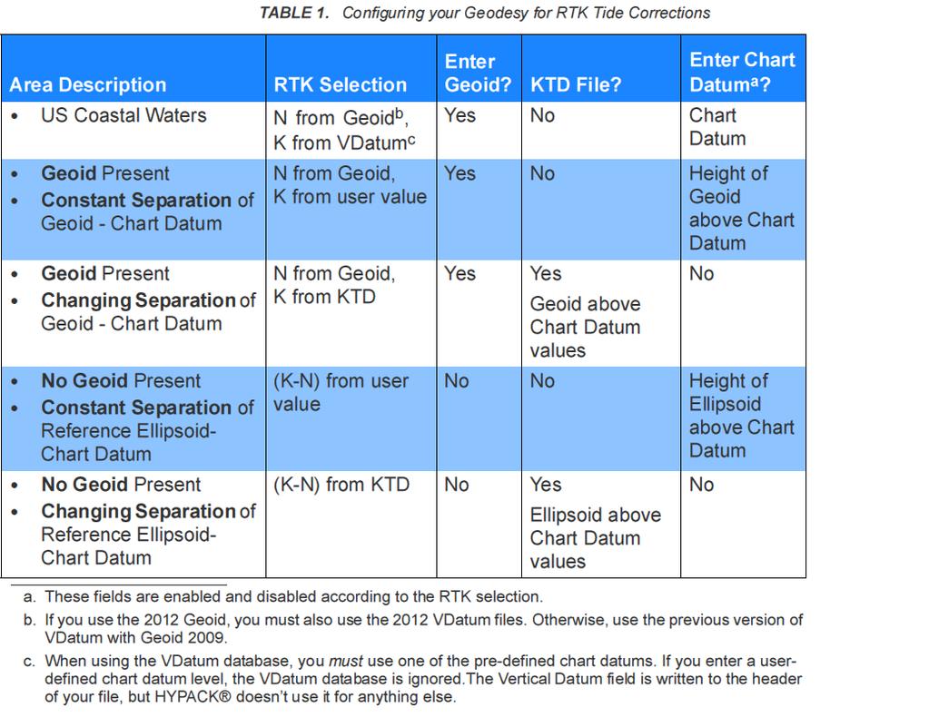
4 Here are the geodesy-related options in HYPACK: 0
5 For surveys with no reduction to LAT, the RTK Tide selection as shown in the HYPACK Geodetic Parameters example is commonly used. The geoid model in HYPACK is applied in place of the one used to generate MSL height inside the receiver. The geoid heights may be shifted up or down equally across the whole survey area using the orthometric height correction. The height of the geoid above chart datum in this case will be zero. KTD files are created during surveys and log the result of K (height of geoid above chart datum) minus N (height of geoid above ellipsoid). This result will change over the survey area and so a KTD file allows a variable correction to the chart datum based on the surveyor s position. One thing to remember about KTD files is that if you are surveying on the geoid datum for RTK Tide elevation results then you can ignore the VDatum or KTD options completely. Note that HYPACK (very sensibly) provide an entry field for an orthometric height correction. This allows the computed tide correction to be further referenced to a local datum where an offset remains. HYPACK give the following diagram to illustrate how the various known fixed and varying parameters are related. In this scenario, a conventional survey using a tide gauge would have a tide reading of +10 metres. Applying this tide reading to the measured depth (i.e. water line to bottom) i.e. applying -10m to the measured sounding would give a chart sounding of 20 metres. The corresponding equation when using RTK is: Tr = -(-H) A (K N) = -H A (K + N) Tr is the RTK tide correction. All measurements are in the metres. H is the antenna height above sea level, i.e. the water line of the boat, i.e. the sea surface, i.e. the geoid & MSL
 If the chart datum was MSL the tide reduction would be 6 metres, i.e. K would be zero.")
6 A (+22) is the height of the antenna above the ellipsoid. N-9 is the height of the ellipsoid above geoid. (in other words the ellipsoid is below the geoid) -4 is height of chart datum above geoid. (in other words the chart datum is below geoid) If the chart datum was MSL the tide reduction would be 6 metres, i.e. K would be zero. There is potential for difficulties when working with RTK because of quality of the geoid models and because of the reliance on good quality corrections from the RTK Base station. Waves & swell can cause short term variations in height not attributable to tide therefore it is normal to average RTK heights over a period of 2 or 3 minutes (A tool for this is available in HYPACK). Variable draft is not of concern for tide data because as boat draft increases antenna height decreases
2 nd Tidal and Water Level Working Group Meeting
 2 nd Tidal and Water Level Working Group Meeting Norwegian Hydrographic Service, Stavanger, Norway 27 29 April 2010 Vertical Offshore Reference Framework (VORF) Chris Jones United Kingdom Hydrographic
Vertical Reference Frame Pacific
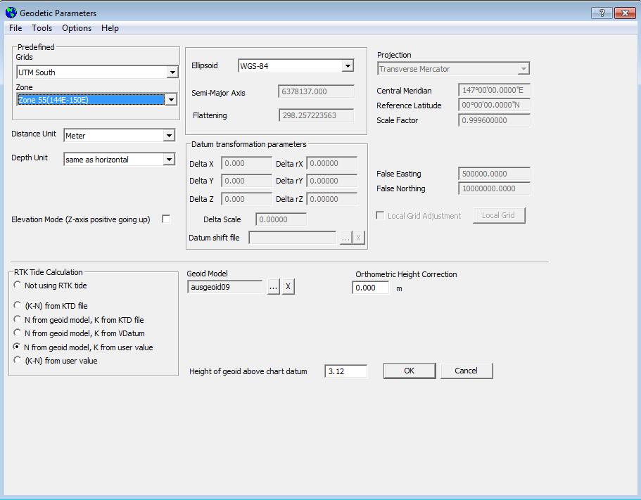
 Vertical Reference Frame Pacific Andrick Lal SPC Geoscience Division GIS&RS User Conference 29 th November 2016 USP, Fiji. What does it mean? All buildings and features have a height. But what is it relative
GPS Surveying Dr. Jayanta Kumar Ghosh Department of Civil Engineering Indian Institute of Technology, Roorkee. Lecture 06 GPS Position
 GPS Surveying Dr. Jayanta Kumar Ghosh Department of Civil Engineering Indian Institute of Technology, Roorkee Lecture 06 GPS Position Friends! Welcome you to sixth class on GPS surveying. Today, I am going
GPS and Mean Sea Level in ESRI ArcPad
 Summary In order to record elevation values as accurately as possible with, it is necessary to understand how ArcPad records elevation. Rather than storing elevation values relative to Mean Sea Level (MSL),
HORIZONTAL PROJECTION PARAMETERS: DANE COUNTY COORDINATES
 Recommended RTK GPS Configuration Parameters for the City of Madison, WI Base Station Compiled by: Dan Rodman RLS, City of Madison (608)266-6674 drodman@cityofmadison.com For base station information see
Geog Lecture 29 Mapping and GIS Continued
 Geog 1000 - Lecture 29 Mapping and GIS Continued http://scholar.ulethbridge.ca/chasmer/classes/ Today s Lecture (Pgs 13-25, 28-29) 1. Hand back Assignment 3 2. Review of Dr. Peddle s lecture last week
Height systems. Rudi Gens Alaska Satellite Facility
 Rudi Gens Alaska Satellite Facility Outline Why bother about height systems? Relevant terms Coordinate systems Reference surfaces Geopotential number 2 Why bother about height systems? give a meaning to
What s Up? Tidal and Vertical Datums. Noel Zinn Hydrometronics LLC July 2011, revised November 2013
 What s Up? Tidal and Vertical Datums Noel Zinn Hydrometronics LLC www.hydrometronics.com July 2011, revised November 2013 1 Motivation The real world is three-dimensional, therefore, coordinates are necessarily
GEOID UNDULATIONS OF SUDAN USING ORTHOMETRIC HEIGHTS COMPARED WITH THE EGM96 ANG EGM2008
 GEOID UNDULATIONS OF SUDAN USING ORTHOMETRIC HEIGHTS COMPARED Dr. Abdelrahim Elgizouli Mohamed Ahmed* WITH THE EGM96 ANG EGM2008 Abstract: Positioning by satellite system determine the normal height above
GEOIDS FAQ. November
 GEOIDS FAQ 1. What is a geoid? A geoid is a representation of the equipotential surface of the Earth s gravity field. It can be thought of as a surface coinciding with the undisturbed mean sea level extended
Ellipsoid Hydro Datum Geoid Errors
 Ellipsoid Hydro Datum Geoid Errors Jack L. Riley Office of Coast Survey Hydrographic Systems & Technology Branch Geoid Errors via Ellipsoid Hydrography? Per datum hydro Traditional & ellipsoid referenced
BUILDING AN ACCURATE GIS
 BUILDING AN ACCURATE GIS 2006 GIS in the Rockies Denver, Colorado September 13, 2006 William E. Linzey United States Department of Commerce National Oceanic and Atmospheric Administration National Geodetic
LEADS. The Essential Elements of a 3-D Geographic Coordinate
 The Essential Elements of a 3-D Geographic Coordinate John W. Dix 13 September 2005 ESRI Homeland Security GIS Summit - Denver, CO John.W.Dix@nga.mil NATIONAL GEOSPATIAL-INTELLIGENCE AGENCY Overview is
MLLW and the NAD83 Ellipsoid: An Investigation of Local Offsets and Trends Using PPK and Gauge Derived Water Surfaces.
 MLLW and the NAD83 Ellipsoid: An Investigation of Local Offsets and Trends Using PPK and Gauge Derived Water Surfaces. Abstract: Authors Doug Lockhart, Fugro Pelagos, Inc. Andy Orthmann, Fugro Pelagos,
Where on Earth are We? Projections and Coordinate Reference Systems
 Where on Earth are We? Projections and Coordinate Reference Systems Nick Eubank February 11, 2018 If I told you that there was a treasure chest buried at the coordinates p2, 5q, your first response might
INTEGRATION OF HYDROGRAPHIC AND TOPOGRAPHIC DATA FOR COASTAL GIS SOLUTIONS
 Integration of data for coastal GIS INTEGRATION OF HYDROGRAPHIC AND TOPOGRAPHIC DATA FOR COASTAL GIS SOLUTIONS Igor KARNIČNIK (Geodetic Institute of Slovenia, Jamova 2, Ljubljana, Slovenia; igor.karnicnik@geod-is.si)
Mobile Mapping Tips and Tricks
 Mobile Mapping Tips and Tricks Projections, Datums and Geoids, May 2017 Introduction This guide is designed to provide a basic understanding of coordinate system projections, datums and geoids. The guide
Charts and Chart Work with Poole Sailing
 with Poole Sailing Nautical charts are a mine of information but they need to be up to date. Corrections to charts are published by the Hydrographic Office monthly as Notices to Mariners both in print
Geographic Information Systems class # 1 February 19, Coordinate reference systems in GIS: geodetic coordinates
 Geographic Information Systems class # 1 February 19, 2013 Coordinate reference systems in GIS: geodetic coordinates Manuel Campagnolo ISA Manuel Campagnolo (ISA) GIS/SIG 2012 2013 February 19, 2013 1
GPS Measurement Protocol
 GPS Measurement Protocol Purpose To determine the latitude, longitude, and elevation of your school and of all your GLOBE sites Overview The GPS receiver will be used to determine the latitude, longitude
Coordinate systems, measured surveys for BIM, total station for BIM, as-built surveys, setting-out
 Coordinate systems, measured surveys for BIM, total station for BIM, as-built surveys, setting-out What is a BIM What does a BIM do Why use a BIM BIM Software BIM and the Surveyor How do they relate to
12/26/2012. Geographic Information Systems * * * * GIS (... yrezaei
 ( - Geographic Information Systems ( ( 1 2 3 Information System Data base DB IS IS DB (Knowledge ( ( (System (Information System - (Georefrence Analysis Data + Knowledge ======== Information 4 5 ( < 10%
1/28/16. EGM101 Skills Toolbox. Oblate spheroid. The shape of the earth Co-ordinate systems Map projections. Geoid
 EGM101 Skills Toolbox Oblate spheroid The shape of the earth Co-ordinate systems Map projections The geoid is the shape that the surface of the oceans would take under the influence of Earth's gravitation
Scott A. True Project Scientist Geodesy & Geophysics Division Basic and Applied Research Office InnoVision Directorate
 EGM96 Variable Resolution Geoid Implementation Error in GEOTRANS 2.3 Scott A. True Project Scientist Geodesy & Geophysics Division Basic and Applied Research Office InnoVision Directorate Introduction
Evaluation of GPS in Orthometric Heights Determination in Khartoum State (Sudan)
") Evaluation of GPS in Orthometric Heights Determination in Khartoum State (Sudan) Dr. Nagi Zomrawi Mohammed 1, Dr. Abd Elrahim Elgizouli Mohammed 2 and Engineer Osman Bakry 3 1 Sudan University of Science
Evaluation of GPS in Orthometric Heights Determination in Khartoum State (Sudan) Dr. Nagi Zomrawi Mohammed 1, Dr. Abd Elrahim Elgizouli Mohammed 2 and Engineer Osman Bakry 3 1 Sudan University of Science
Coordinate Systems. Location on earth is defined by coordinates
 Coordinate Systems We think of the earth as a sphere It is actually a spheroid (ellipsoid), slightly larger in radius at the equator than at the poles Shape of the Earth Location on earth is defined by
International Journal of Computer Science and Telecommunications [Volume 3, Issue 7, July 2012] 109. Levelling with GPS. Dr. Nagi Zomrawi Mohammed
![International Journal of Computer Science and Telecommunications [Volume 3, Issue 7, July 2012] 109. Levelling with GPS. Dr. Nagi Zomrawi Mohammed](/thumbs/94/120062601.jpg "International Journal of Computer Science and Telecommunications [Volume 3, Issue 7, July 2012] 109. Levelling with GPS. Dr. Nagi Zomrawi Mohammed") International Journal of Computer Science and Telecommunications [Volume 3, Issue 7, July 2012] 109 ling with ISSN 2047-3338 Dr. Nagi Zomrawi Mohammed Associate Professor, College of Engineering, Sudan
International Journal of Computer Science and Telecommunications [Volume 3, Issue 7, July 2012] 109 ling with ISSN 2047-3338 Dr. Nagi Zomrawi Mohammed Associate Professor, College of Engineering, Sudan
VT State Plane. Daniel J. Martin National Geodetic Survey VT Geodetic Advisor. VSLS Conference Rutland VT April 11, 2008
 VT State Plane Daniel J. Martin National Geodetic Survey VT Geodetic Advisor VSLS Conference Rutland VT April 11, 2008 Today s Outline Define the problem Review of VT State Plane System Relationship
Geodesy. orientation. shape. gravity field
 Geodesy noun Science of measuring the shape, orientation and gravity field of the Earth and how it changes over time. shape orientation gravity field Positioning has always been important Downstream applications
Map projections. Rüdiger Gens
 Rüdiger Gens Coordinate systems Geographic coordinates f a: semi-major axis b: semi-minor axis Geographic latitude b Geodetic latitude a f: flattening = (a-b)/a Expresses as a fraction 1/f = about 300
Geo Referencing & Map projections CGI-GIRS 0910
 Geo Referencing & Map projections CGI-GIRS 0910 Where are you? 31UFT8361 174,7 441,2 51 58' NB 5 40' OL 2/60 Who are they? 3/60 Do geo data describe Earth s phenomena perfectly? Georeference systems ellipsoid
Version 1.1 GIS Syllabus
 GEOGRAPHIC INFORMATION SYSTEMS CERTIFICATION Version 1.1 GIS Syllabus Endorsed 1 Version 1 January 2007 GIS Certification Programme 1. Target The GIS certification is aimed at: Those who wish to demonstrate
Height systems. Rüdiger Gens
 Rüdiger Gens 2 Outline! Why bother about height systems?! Relevant terms! Coordinate systems! Reference surfaces! Geopotential number! Why bother about height systems?! give a meaning to a value defined
When the Earth Was Flat. Measurements were made using a plumb bob, a spirit level, and a stick. Also, the Stars.
 ABSTRACT Defining the shape of the Earth geoid. Mathematical models spheroid or ellipsoid Mathematical projection of geodetic systems GIS/GPS technology The need for a unified projection systems World
Town of Chino Valley. Survey Control Network Report. mgfneerhg mc N. Willow Creek Road Prescott AZ
 Town of Chino Valley Survey Control Network Report mgfneerhg mc. 2050 N. Willow Creek Road Prescott AZ 86301 928-771-2376 Page 1 of 70 Table of Contents Town of Chino Valley Survey Datum Outline A short
Geo Referencing & Map projections CGI-GIRS 0910
 Geo Referencing & Map projections CGI-GIRS 0910 Where are you? 31UFT8361 174,7 441,2 51 58' NB 5 40' OL 2/60 Who are they? 3/60 Do geo data describe Earth s phenomena perfectly? Georeference systems ellipsoid
GEOGRAPHIC COORDINATE SYSTEMS
 GEOGRAPHIC COORDINATE SYSTEMS Introduction to GIS Winter 2015 What is Georeferencing? Used to establish a location on the Earth s surface 1 st order polynomial transformation Georeferencing toolbar What
Boolean Operators and Topological OVERLAY FUNCTIONS IN GIS
 Boolean Operators and Topological OVERLAY FUNCTIONS IN GIS Query asking a question of the attribute data Standard Query Language (SQL) is used to query the data There are 4 basic statements used to get
Workshop on GNSS Data Application to Low Latitude Ionospheric Research May Fundamentals of Satellite Navigation
 2458-6 Workshop on GNSS Data Application to Low Latitude Ionospheric Research 6-17 May 2013 Fundamentals of Satellite Navigation HEGARTY Christopher The MITRE Corporation 202 Burlington Rd. / Rte 62 Bedford
PGM2016: A new geoid model for the. Philippines
 PGM2016: A new geoid model for the Philippines United Nations/Nepal Workshop on the Applications of Global Navigation Satellite Systems Kathmandu, Nepal December 12-16, 2016 Ronaldo Gatchalian, Chief Geodesy
Choosing the wrong spheroid
 Reality Check The E&P industry has experienced avoidable costs in its encounters with the science and methodology of geodesy and cartography. The following are explicit case histories of real problems
CHAIRMAN OF THE JOINT CHIEFS OF STAFF INSTRUCTION
 CHAIRMAN OF THE JOINT CHIEFS OF STAFF INSTRUCTION J-3 CJCSI 3900.01C DISTRIBUTION: A, B, C, J POSITION (POINT AND AREA) REFERENCE PROCEDURES Reference: DODD 5105.60, 11 October 1996, National Imagery and
Frames for the Future New Datum Definitions for Modernization of the U.S. National Spatial Reference System
 Figure 10. Horizontal position differences (in meters) between NAD 83 and ITRF 08 at time 2022.00 (January 1, 2022). Positional differences are shown for the North American and Pacific tectonic plates.
Lesson 5: Map Scale and Projections
 Organizing Data and Information Lesson 5: Map Scale and Projections Map Scales Projections Information can be organized as lists, numbers, tables, text, pictures, maps, or indexes. Clusters of information
A guide to coordinate systems in Great Britain
 A guide to coordinate systems in Great Britain An introduction to mapping coordinate systems and the use of GPS datasets with Ordnance Survey mapping Contents Section Page no 1 Introduction... 3 1.1 Who
Introduction to Geographic Information Science. Updates/News. Last Lecture. Geography 4103 / Map Projections and Coordinate Systems
 Geography 4103 / 5103 Introduction to Geographic Information Science Map Projections and Coordinate Systems Updates/News Thursday s lecture Reading discussion 1 find the readings online open questions,
Fusion of Geodesy and GIS at NOAA s National Geodetic Survey
 Fusion of Geodesy and GIS at NOAA s National Geodetic Survey Esri Survey Summit July 6-9, 2013 San Diego, CA Michael Dennis, RLS, PE michael.dennis@noaa.gov The Plan Background NGS Data Explorer New Datasheet
Coordinate Systems and Datum Transformation in ArcGIS. Brittney White and Melita Kennedy
 Coordinate Systems and Datum Transformation in ArcGIS Brittney White and Melita Kennedy Where is my data? Problem Horizontal Vertical Projections Transformations Horizontal coordinate systems Geographic
This week s topics. Week 6. FE 257. GIS and Forest Engineering Applications. Week 6
 FE 257. GIS and Forest Engineering Applications Week 6 Week 6 Last week Chapter 8 Combining and splitting landscape features and merging GIS databases Chapter 11 Overlay processes Questions? Next week
Height Modernization 2013 A New Canadian Vertical Datum
 Height Modernization 2013 A New Canadian Vertical Datum What is Height Modernization? The Height Reference System Modernization is a project at the Geodetic Survey Division (GSD) of Natural Resources Canada
Principles of Global Positioning Systems Spring 2008
 MIT OpenCourseWare http://ocw.mit.edu 12.540 Principles of Global Positioning Systems Spring 2008 For information about citing these materials or our Terms of Use, visit: http://ocw.mit.edu/terms. 12.540
GEOMATICS ENGINEERING / SURVEYING
 1 GEOMATICS ENGINEERING / SURVEYING CHAPTER 1 Dr. Muhammad Ashraf Javid Assistant Professor Department of Civil and Environmental Engineering Email: muhammad.javid@unizwa.edu.om 2 Geomatics Engineering
The Gauss Conform Coordinate
 Surveying The South African Coordinate Reference System (Part 2) by Aslam Parker, Chief Directorate: National Geo-spatial Information Part 1 of this article (see PositionIT Nov/Dec 2011) focused on the
Meeting the ODOT Survey & Mapping Specifications
 Meeting the ODOT Survey & Mapping Specifications A Simple Solution Presented by Ray Foos, P.S, ODOT CADD & Mapping Services & Jon Keller, P.S., ODOT District 3 Phases of an ODOT Survey Project Research
Geospatial Data Standards Considerations for the delivery of 2D and 3D spatial data February 2019
 Geospatial Data Standards Considerations for the delivery of 2D and 3D spatial data February 2019 Prepared by: GRCA Geomatics Version Date Summary of Changes Changes Made By: 1.00 March 16, 2018 Version
The 3-D Global Spatial Data Model: Geometrical Foundation of the Global Spatial Data Infrastructure
 The 3-D Global Spatial Data Model: Geometrical Foundation of the Global Spatial Data Infrastructure Earl F. Burkholder, PS, PE Annotated Table of Contents July 8,2006 I. The Global Spatial Data Model (GSDM)
What is Geodesy? Types of Geodesy terrestrial or classical geodesy space geodesy theoretical geodesy
 What is Geodesy? Geodesy is the study of: The size, shape and motion of the earth The measurement of the position and motion of points on the earth's surface, and The study of the earth's gravity field
Outline. Shape of the Earth. Geographic Coordinates (φ, λ, z) Ellipsoid or Spheroid Rotate an ellipse around an axis. Ellipse.
 Ellipsoid or Spheroid Rotate an ellipse around an axis. Ellipse.") Map Projections Outline Geodesy and map projections Prof. D. Nagesh Kumar Department of Civil Engineering Indian Institute of Science Bangalore 560 012, India http://www.civil.iisc.ernet.in/~nagesh Shape
Map Projections Outline Geodesy and map projections Prof. D. Nagesh Kumar Department of Civil Engineering Indian Institute of Science Bangalore 560 012, India http://www.civil.iisc.ernet.in/~nagesh Shape
5 Coordinate Reference Systems
 5 Coordinate Reference Systems 5.1 Overview The INSPIRE theme Coordinate reference systems (CRS) provides a harmonised specification for uniquely referencing spatial information, either using three-dimensional,
The National Spatial Reference System of the Future
 The National Spatial Reference System of the Future William Stone Southwest Region (AZ, NM, NV, UT) Geodetic Advisor william.stone@noaa.gov NOAA s National Geodetic Survey geodesy.noaa.gov Salt Lake City
Approaches to GNSS & Geodesy
 Approaches to GNSS & Geodesy Ray Hintz Univ. of Maine Ray.hintz@.maine.edu The biggest complaint about state plane coordinates The concept that scale and elevation factor need to be applied to the pythagoreum
Geodesy on the move. Craig Allinson. Dealing with dynamic coordinate reference systems. IOGP Geodesy Subcommittee. EPUG London, November 2017
 Geodesy on the move Dealing with dynamic coordinate reference systems Craig Allinson IOGP Geodesy Subcommittee EPUG London, November 2017 Why the concern? A bridge too far Historic geodesy mental image
Final VRF grids Date: Aug 25, 2011 Author: R. Forsberg, G. Strykowski, O. Andersen
 Final VRF grids Date: Aug 25, 2011 Author: R. Forsberg, G. Strykowski, O. Andersen www.blast-project.eu 1 Authors Name Organisation Rene Forsberg National Space Institute, DTU G. Strykowski National Space
A Guide to Coordinate Systems in Great Britain
 GEODESY & POSITIONING A Guide to Coordinate Systems in Great Britain An introduction to mapping coordinate systems and the use of GNSS datasets with Ordnance Survey mapping Page 1 of 53 Contact Us Ordnance
Downloaded from MILITARY STANDARD DEPARTMENT OF DEFENSE WORLD GEODETIC SYSTEM (WGS)
") METRIC 11 JANUARY 1994 MILITARY STANDARD DEPARTMENT OF DEFENSE WORLD GEODETIC SYSTEM (WGS) AMSC N/A AREA MCGT DISTRIBUTION STATEMENT A. Approved for public release; distribution is unlimited. FOREWORD
METRIC 11 JANUARY 1994 MILITARY STANDARD DEPARTMENT OF DEFENSE WORLD GEODETIC SYSTEM (WGS) AMSC N/A AREA MCGT DISTRIBUTION STATEMENT A. Approved for public release; distribution is unlimited. FOREWORD
What is a Map Projection?
 What is a Map Projection? It is how we represent a three dimensional Earth on a flat piece of paper However The process of transferring information from the Earth to a map causes every projection to distort
Principles of the Global Positioning System Lecture 04"
 12.540 Principles of the Global Positioning System Lecture 04" Prof. Thomas Herring" Room 54-820A; 253-5941" tah@mit.edu" http://geoweb.mit.edu/~tah/12.540 " Review" So far we have looked at measuring
Low Distortion Projections Part 2 Ground versus Grid
 Blue Marble Geographic Calculator provides an incredible variety of tools for working with an infinite combination of datums and projections. Shown here, I ve entered the parameters for a Low Distortion
Client RSK Environment Ltd Job No. J387 Date 19/11/2016. Project: Environmental Survey Location: Otranto Vessel: RV Atlante
 FUGRO OCEANSISMICA S.p.A. GEODETIC PARAMETERS Client RSK Environment Ltd Job No. J387 Date 19/11/216 Project: Environmental Survey Location: Otranto Vessel: RV Atlante WGS-84 Geodetic Parameters Datum
The GOCE Geoid in Support to Sea Level Analysis
 The GOCE Geoid in Support to Sea Level Analysis The geoid is a very useful quantity for oceanographers Thomas Gruber Astronomical & Physical Geodesy (IAPG) Technische Universität München 1. Characteristics
TOWARDS ROBUST LOCALIZATION OF RTK-GPS TOPOGRAPHIC SURVEYS 23
 TOWARDS ROBUST LOCALIZATION OF RTK-GPS TOPOGRAPHIC SURVEYS Jerry W. Nave, North Carolina A&T University; Tarig A. Ali, American University of Sharjah Abstract Localization is performed to fit the observed
IRENE: Visitor from the Extratidal World
 IRENE: Visitor from the Extratidal World John Boon Professor Emeritus Virginia Institute of Marine Science School of Marine science College of William and Mary Hurricane Irene did not come to Hampton Roads
Why do we need a proper geoid
 Why do we need a proper geoid Petr Vaníček Department of Geodesy and Geomatics Engineering University of New Brunswick P.O. Box 4400 Fredericton, N.B. CND E3B 53 1 My working hypothesis: Let us all agree
Geodetic applications of GNSS in the Black Sea region
 BALGEOS II - Balkan countries integration into GGOS Second workshop, 27-29 January, 2010 Vienna - AUSTRIA Geodetic applications of GNSS in the Black Sea region Lyubka Pashova CENTRAL LABORATORY OF GEODESY
Abstract. Introduction
 Calculation of Area and Volume for the South Part of Great Salt Lake, Utah Prepared in cooperation with the Utah Department of Natural Resources, Division of Wildlife Resources By Robert L. Baskin Survey
Control Surveys and Coordinate Systems
 Control Surveys and Coordinate Systems The Earth is Round Basic Shape of the Earth: Oblate Spheroid of Revolution The length of the equatorial axis is approximately 27 miles greater than the polar axis.
Intro to GIS Fall 2010 Georeferencing & Map Projections
 Intro to GIS Fall 2010 Georeferencing & Map Projections SHAPE OF THE EARTH Earth's Shape Geoid: shape of earth minus topographic features (irregular due to local variations in gravity) Ellipsoid: elongated
MODERNIZATION OF THE NSRS
 NATRF 2022 AND LDP SEPTEMBER 12, 2017 MODERNIZATION OF THE NSRS Why? Leaving passive control marks behind and relying solely on the CORS network for 3D positions: Older methodology relies on terrestrial
H.A.R.S. PRA #1 (Historic Area Remediation Site)
") H.A.R.S. PRA #1 (Historic Area Remediation Site) 2009 Multibeam Bathymetry TABLE OF CONTENTS Page LIST OF TABLES 2 LIST OF FIGURES 3 1.0 INTRODUCTION 4 2.0 OBJECTIVE 4 3.0 PROCEDURE 4 3.1 DATA ACQUISITION
H.A.R.S. PRA #1 (Historic Area Remediation Site) 2009 Multibeam Bathymetry TABLE OF CONTENTS Page LIST OF TABLES 2 LIST OF FIGURES 3 1.0 INTRODUCTION 4 2.0 OBJECTIVE 4 3.0 PROCEDURE 4 3.1 DATA ACQUISITION
Positioning in the Pacific Islands
 Positioning in the Pacific Islands Andrick Lal United Nations/Nepal Workshop on the Applications of Global Navigation Satellite Systems Kathmandu - Nepal 15 th December 2016 Presentation Outline Introduction
Global Journal of Engineering Science and Research Management
 QUALITY ANALYSIS OF GPS DATA PROCESSED BY EARTH GRAVITATIONAL MODEL (EGM2008) OF HILLA AREA, IRAQ Prof. Dr. Hussein H. Karim*, Asst. Prof. Dr. Imzahim A. Alwan, Basheer S. Jasim * Professor, Building and
King County Explorer Search and Rescue. Course B Map & Compass
 King County Explorer Search and Rescue Course B Map & Compass Disclaimer The intent of this presentation is to provide a basic overview of maps, compasses, and location finding. It is not meant to be a
4 Survey Datums. 4.1 Horizontal Datum Policy SURVEY DATUMS SEPTEMBER 2006
 4 Survey Datums Today s multi-organizational Project Development efforts require the use of common, accurate horizontal and vertical survey datums and consistent, precise control-survey procedures to ensure
PPDM Data Management Symposium March 7, 2012 Houston
 Experts in Geomatics, Surveying, Positioning, Geospatial Data, and Mapping Sciences PPDM Data Management Symposium March 7, 2012 Houston Michael Barnes APSG Foundation Chair 2010-2015 APSG Chair 2008-2009
REFERENCING COORDINATE SYSTEMS MAP PROJECTIONS GEOREFERENCING
 GIS in Ecology SPATIAL REFERENCING COORDINATE SYSTEMS MAP PROJECTIONS GEOREFERENCING : :1 Where on earth? Early mapmakers recognized the need for a system that could locate features on the earth's surface.
Ellipsoidally Referenced Surveys Separation Models
 Ellipsoidally Referenced Surveys Separation Models David DODD - Canada Jerry MILLS - USA Key words: Hydrography, Ellipsoid, Chart Datum Summary One of the most significant issues in hydrography today is
The Elements of GIS. Organizing Data and Information. The GIS Database. MAP and ATRIBUTE INFORMATION
 GIS s Roots in Cartography Getting Started With GIS Chapter 2 Dursun Z. Seker MAP and ATRIBUTE INFORMATION Data (numbers and text) store as files refer to them collectively as a database gather inform.
ch02.pdf chap2.pdf chap02.pdf
 Introduction to Geographic Information Systems 8th Edition Karl Solutions Manual Full Download: http://testbanklive.com/download/introduction-to-geographic-information-systems-8th-edition-karl-solutions-manu
Data acquisition and integration 1.
 Data acquisition and integration 1. Ferenc Végső Data acquisition and integration 1.: Ferenc Végső Lector: Árpád Barsi This module was created within TÁMOP - 4.1.2-08/1/A-2009-0027 "Tananyagfejlesztéssel
Wed. Apr. 25, 2018 GIS DEMO. Reading: Ch Comparing Image Types (Death Valley) Treat as review of techniques already studied
 Treat as review of techniques already studied") Wed. Apr. 25, 2018 GIS DEMO Reading: Ch. 14 -- Comparing Image Types (Death Valley) Treat as review of techniques already studied 1 GIS: Geographic Information Systems Way to organize data obtained by
Wed. Apr. 25, 2018 GIS DEMO Reading: Ch. 14 -- Comparing Image Types (Death Valley) Treat as review of techniques already studied 1 GIS: Geographic Information Systems Way to organize data obtained by
Preventing Coordinate- System Confusion (maybe?)
") Preventing Coordinate- System Confusion (maybe?) Montana Association of Registered Land Surveyors 2008 Convention Bozeman, Montana 07 & 08 February 2008 Glenn Borkenhagen Inland GPS Inc. - Cody, Wyoming
Preventing Coordinate- System Confusion (maybe?) Montana Association of Registered Land Surveyors 2008 Convention Bozeman, Montana 07 & 08 February 2008 Glenn Borkenhagen Inland GPS Inc. - Cody, Wyoming
Military Map Reading 201
 Military Map Reading 201 This information paper is designed to resolve the confusion between the Universal Transverse Mercator (UTM) and the Military Grid Reference System (MGRS) coordinates. The two systems
Proceedings of the First International Conference on Civil Engineering, Assiut University, Volume 2, pp , October 7-8.
 Proceedings of the First International Conference on Civil Engineering, Assiut University, Volume 2, pp. 246-253, October 7-8. PRODUCTIVE GPS TOPOGRAPHIC MAPPING FOR NATIONAL DEVELOPMENT PROJECTS IN EGYPT
Semi-Dynamic Datum of Indonesia
 Technical Seminar Reference Frame in Practice, Semi-Dynamic Datum of Indonesia H.Z. Abidin, A.B. Wijanarto, S.T. Wibowo, Susilo, J. Efendi Geospatial Information Agency, Indonesia (BIG) Sponsors: Page
Understanding Projections for GIS
 Presented by John Schaeffer Juniper GIS Services, Inc. This PowerPoint is available at JuniperGIS.com Presentation Objectives To understand basic concepts on projections and coordinate systems for the
NATRF 2022 AND LDP OCTOBER 11, 2017
 NATRF 2022 AND LDP OCTOBER 11, 2017 MODERNIZATION OF THE NSRS Why? Leaving passive control marks behind and relying solely on the CORS network for 3D positions: Older methodology relies on terrestrial
CONTROL MONUMENT REPORT
 CONTROL MONUMENT REPORT This document was prepared by Altus Geomatics for use by City of Yorkton staff and contractors working in and for the City of Yorkton. This document is meant to inform readers about
Georeferencing. Where on earth are we? Critical for importing and combining layers for mapping
 Georeferencing Where on earth are we? Critical for importing and combining layers for mapping 1. The Geoid Earth is not a perfect sphere, it is ellipsoidal.. earth is the 'Geoid'. The difference between
Data acquisition and integration 1.
 University of West Hungary, Faculty of Geoinformatics Ferenc Végső Data acquisition and integration 1. module DAI1 The basics of positioning SZÉKESFEHÉRVÁR 2010 The right to this intellectual property
Projections & GIS Data Collection: An Overview
 Projections & GIS Data Collection: An Overview Projections Primary data capture Secondary data capture Data transfer Capturing attribute data Managing a data capture project Geodesy Basics for Geospatial