HIGH RESOLUTION RAPID REFRESH COUPLED WITH SMOKE (HRRR- SMOKE): REAL-TIME AIR QUALITY MODELING SYSTEM AND ITS APPLICATION TO CASE STUDIES
|
|
|
- Stanley Jennings
- 6 years ago
- Views:
Transcription


1 HIGH RESOLUTION RAPID REFRESH COUPLED WITH SMOKE (HRRR- SMOKE): REAL-TIME AIR QUALITY MODELING SYSTEM AND ITS APPLICATION TO CASE STUDIES Ravan Ahmadov 1,2 Acknowledgement: G. Grell 2, E. James 1,2, C. Alexander 2, S.Benjamin 2, B.Jamison 1,2, T.Alcott 2, J. Stewart 1,2, S. Freitas 3, G. Pereira 3, 4, I. Csiszar 5, M. Tsidulko 8, B. Pierce 6, S. McKeen 1,2, S. Peckham 7, L. Deanes 8, A. Edman 10, M. Goldberg 11, B. Sjoberg 11 JPSS proving ground and risk reduction program 1 Cooperative Institute for Research in Environmental Sciences, University of Colorado at Boulder, Boulder, CO, USA 2 Earth System Research Laboratory, NOAA, Boulder, CO, USA 3 NASA Goddard Space Flight Center & USRA/GESTAR, Greenbelt, MD, USA 4 Federal University of São João del-rei, MG, Brazil 5 Center for Satellite Applications and Research, NOAA/NESDIS, College Park, MD, USA, 6 Advanced Satellite Products Branch, Center for Satellite Applications and Research, NOAA/NESDIS, Madison, WI, USA 7 Cold Regions Research and Engineering Laboratory, US Army Corps of Engineers, Hanover, NH, USA 8 I.M. Systems Group, Inc, Rockville, MD, USA 9 National Weather Service, NOAA, USA 10 now at Penn State, University Park, PA, USA 11 NOAA's Joint Polar Satellite System Program Office 4 th Biannual Western Modeling Workshop September 8, 2017
2 Introduction High-Resolution Rapid Refresh (HRRR) is a numerical weather prediction system running operationally at the National Weather Service and in real time at NOAA Earth System Research Laboratory/ Global Systems Division (NOAA/ESRL/GSD). The model is run at 3km resolution over the CONUS domain with an hourly update cycle. At present mostly offline air quality models with relatively coarser resolution are used for smoke forecast. Some of these models do not simulate plume rise. A very few air quality models use the satellite Fire Radiative Power (FRP) data to estimate wildfire emissions and plume rise. The goal of this project Towards the Inclusion of VIIRS Fire Products into the HRRR Real-Time Forecasts funded by the JPSS PGRR program is to include the VIIRS products like FRP data into a coupled air quality model (HRRR-Smoke), in order to improve the numerical prediction of fire emissions and smoke dispersion in forecast models used at NOAA, and also to improve weather forecasting. The HRRR-Smoke model configuration is based on the HRRR model with added smoke tracer emitted as fine particulate matter by biomass burning emissions (including simulation of plume rise by the model). 2
.")
3 HRRR-Smoke model The primary advantages of the HRRR-Smoke modeling system: High spatial resolution to allow simulation of mesoscale flows and smoke dispersion over complex terrain. Full coupling between meteorology and smoke: feedback of smoke on predicted radiation, cloudiness, and precipitation (using double moment microphysics). Biomass burning emissions and inline plume rise parameterization based on the satellite FRP data. A rapidly updating data assimilation cycle for meteorology; HRRR-Smoke uses meteorological input data prepared by the GSI data assimilation system and boundary conditions from another weather forecast model: Rapid Refresh (RAP). The forecast lead time is 36 hours. Four times a day (00, 06, 12 and 18UTC) a new forecast starts. Operational weather forecast models at NWS: RAP (white), 13km resolution HRRR model CONUS domain (green), 3km resolution (


4 Mapping the VIIRS FRP data to the HRRR-Smoke CONUS grid The clustering procedure performs a combination of all detected fires from VIIRS according to the model spatial resolution and grid configuration. Averaged VIIRS FRP data mapped over 3x3km HRRR CONUS grid pixels for July 19,
5 Workflow of the real-time HRRR-Smoke modeling system Real-time VIIRS FRP data from the NESDIS ftp server Processing the FRP data on NOAA HPC in real-time (mapping, calculating fire size over the HRRR domain) Calculating fire emissions, and other parameters using the prep_chem tool Initial and boundary conditions for meteorology from the experimental RAP and HRRR weather forecast models run on NOAA HPC HRRR-Smoke real-time runs on NOAA HPC, 36hr forecasts Post processing of the HRRR-Smoke output using Unified Post Processor The experimental HRRR-Smoke started in June, The system is run 4 times a day at 00, 06, 12 and 18 UTC. It takes ~4 hours to complete entire cycle. Forecast plots are posted as simulations progress. Two NOAA HPC systems (Jet and Theia) are used. Multiple real-time datasets (meteorological observations, GFS model output, satellite ) are used. The forecast lead time is 36 hours. Providing output files in GRIB2 format to various users Plotting of the FRP and smoke fields and posting on the GSD web-site

6 The real-time HRRR-Smoke web-site for public access (rapidrefresh.noaa.gov/hrrr/hrrrsmoke/) 6
 concentrations and wind at the first model level (~8m above ground).")
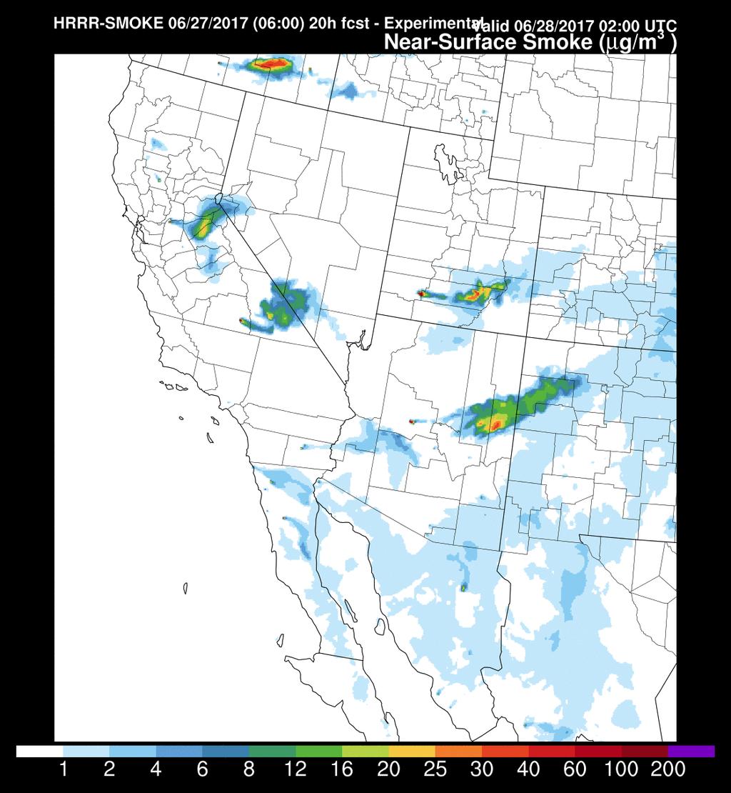
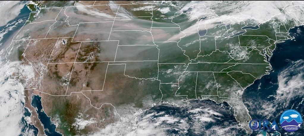
7 Smoke forecast for July 19, 2017 (rapidrefresh.noaa.gov/hrrr/hrrrsmoke/) This plot shows simulated fire emitted fine particulate matter (PM2.5 or fire smoke) concentrations and wind at the first model level (~8m above ground). The following plot shows forecast of near-surface fire smoke for July 19, 8pm EDT over the CONUS and its subdomain. This forecast is based on the model simulation of 24 hours from the model initialization time, which is 8pm EDT, July 18,

8 Fire plume rise dynamics Paugam et al., ACP,

9 Smoldering and flaming emissions in HRRR-Smoke To calculate plume rise we need to know heat flux. The traditional approach in WRF-Chem to calculate plume rise: Use constant fire released heat flux numbers for a given land use class, e.g. Tropical Forest: min and max heat flux = 30, 80 kw/m2 New approach used in HRRR-Smoke: Heat flux ~ FRP/ burnt_area FRP measured by satellites Burnt_area is determined by using fire size M.Bela et al. (WRF-Chem tutorial) 9

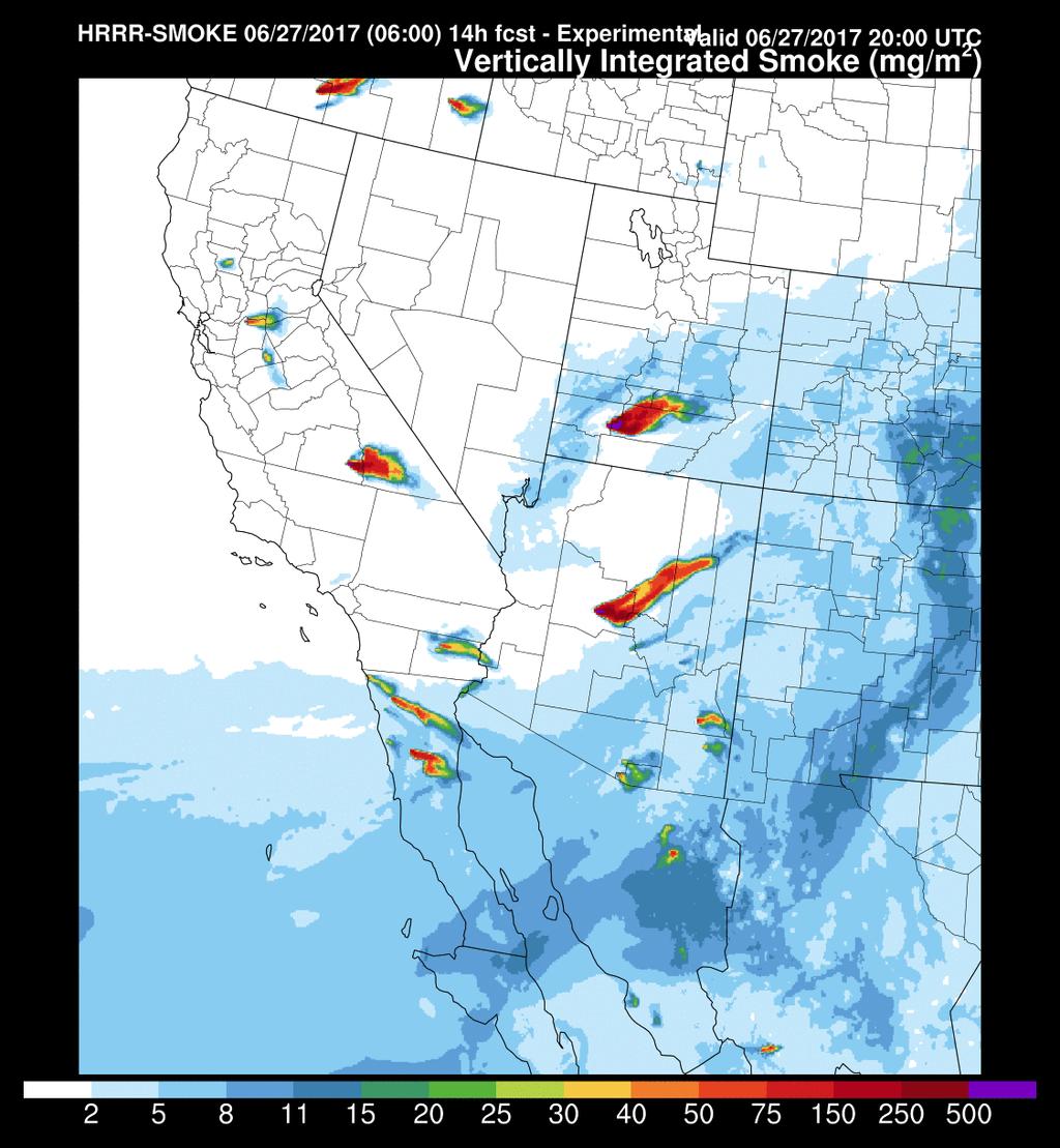
10 Smoke concentration along WE x-section Forecast for June 27, 4pm EDT 10
11 11
 www.guardian.")

12 1) VISUALIZATION OF FIRE RADIATIVE POWER (FRP) FROM VIIRS SATELLITE DATA (AUGUST 17-31, 2015) Active fires from the Suomi NPP VIIRS: Product status and first evaluation results, Csiszar et al., JGR, 2013/
13 AIR QUALITY MONITORING SITES ACROSS THE WESTERN US
14
15


16 Mean Bias = ug/m 3 RMSE = ug/m 3

17 r =.49 Mean Bias = ug/m 3 RMSE = 45.8 ug/m 3


18 HRRR-Smoke simulated vertically integrated aerosol concentrations and aerosol optical depth from VIIRS for August 27, 2015 The model does NOT assimilate the VIIRS AOD data! Modeled vertically integrated aerosol concentrations VIIRS AOD VIIRS data are also very useful for independent model verification!


19 VIIRS smoke mask and HRRR-Smoke forecast for vertically integrated smoke, July VIIRS AOD with smoke mask HRRR-Smoke VIIRS AOD data could be used in model evaluations 20


20 Qualitative comparisons of the GOES-R images with the HRRR-Smoke forecasts The Detliwer fire GOES-R image, 00:30 UTC, July Vertically integrated smoke forecast 01UTC, July 20


21 Recent megafire in Central Valley, CA ( 22
 in")


22 Simulating smoke feedback (direct and indirect) in HRRR-Smoke using double moment Thompson microphysics scheme 23 Adapted from J.Fast (WRF-Chem tutorial)

23 HRRR-Smoke weather prediction with and w/o smoke feedback on meteorology Difference in shortwave radiation between HRRR-Smoke simulations without smoke feedback and feedback included, 8pm EDT, August 20, 2016 Sensitivity study using HRRR-Smoke for August 12-20, 2016 Temperature bias verification of 18 hour model forecast using radiosounding measurements in the US Mean temperature bias No feedback With feedback Difference Including smoke feedback on meteorology reduces forecasted temperature bias.
24 Recent updates to the HRRR-Smoke modeling system Starting August, 2017: HRRR-Smoke is ingesting FRP data from the MODIS Terra and Aqua satellites in addition to VIIRS HRRR-Smoke preprocessor is using FEER (Fire Energetics and Emissions Research) emission coefficients [Ichoku and Ellison, 2014] to estimate the biomass burning emissions Smoke feedback on radiation and microphysics is included in the real-time HRRR-Smoke 25
25 GOES-R 26
26 Concluding remarks and future plans The real-time HRRR-Smoke modeling system provides an online smoke forecasting tool, which is used by incident meteorologists, air quality agencies, researchers and the public. The model can help us to improve weather forecasting by accounting for smoke impact on meteorology. The real-time VIIRS provides valuable datasets (AOD) for modeling fire emissions and model verification. Adding visibility product to the forecast output; Transitioning our smoke parameterization to NOAA s future NGGPS global modeling system; Using HRRR-Smoke (including NGGPS-Smoke in future) for upcoming intensive field campaigns in the US (FIREX, FIRE- Chem, WE-CAN) and further verification and refinement of the model using future aircraft measurements (e.g. parameterization of injection heights and emission factors); Use high frequency GOES-R FRP data for rapid update of fire detection and emissions; Synergy with the GOES-R initiated fire and smoke related activities; More rigorous evaluations are necessary. How best we can validate the smoke models? 27
27 THANK YOU FOR YOUR ATTENTION! QUESTIONS OR COMMENTS? 28
COORDINATION GROUP FOR METEOROLOGICAL SATELLITES AND GOFC-GOLD
 Coordination Group for Meteorological Satellites - CGMS COORDINATION GROUP FOR METEOROLOGICAL SATELLITES AND GOFC-GOLD Mitch Goldberg, CGMS co-liaison to CGMS Working group 2 satellite data and products
weather forecast Improving NOAA models for energy Stan Benjamin, Boulder, CO USA Joseph Olson, Curtis Alexander, Eric James,
 Lamont, OK X Obs radar 5h HRRR Forecast Improving NOAA weather forecast models for energy Stan Benjamin, Joseph Olson, Curtis Alexander, Eric James, Dave Turner, Melinda Marquis NOAA Earth System Research
GFAS Methodology & Results
 GFAS Methodology & Results Johannes W. Kaiser, Imke Hüser, Berit Gehrke Max Planck Institute for Chemistry, DE Tadas Nikonovas, Weidong Xu, Martin G. Wooster King s College London, UK Ioannis Bistinas,
Impact of assimilating the VIIRS-based CrIS cloudcleared radiances on hurricane forecasts
 Impact of assimilating the VIIRS-based CrIS cloudcleared radiances on hurricane forecasts Jun Li @, Pei Wang @, Jinlong Li @, Zhenglong Li @, Jung-Rim Lee &, Agnes Lim @, Timothy J. Schmit #, and Mitch
2012 and changes to the Rapid Refresh and HRRR weather forecast models
 2012 and 2013-15 changes to the Rapid Refresh and HRRR weather forecast models 31 October 2012 Stan Benjamin Steve Weygandt Curtis Alexander NOAA Earth System Research Laboratory Boulder, CO FPAW - 2012
On the assimilation of hyperspectral infrared sounder radiances in cloudy skies
 On the assimilation of hyperspectral infrared sounder radiances in cloudy skies Jun Li 1, Pei Wang 1, Zhenglong Li 1, Jinlong Li 1 and Mitchell D. Goldberg 2 1 Cooperative Institute for Meteorological
Introduction to WRF-Chem
 Introduction to WRF-Chem Georg Grell Steven E. Peckham, Stuart A. McKeen, Jan Kazil, R. Ahmadov + others from NOAA/ESRL Jerome Fast, William Gustafson jr., P.L. Ma, B. Singh+ many others from PNNL + Alma
CONDUIT Update Cooperative Opportunity for NCEP Data using IDD Technology Rebecca Cosgrove NCEP/NCO/Production Management Branch September 15, 2014
 CONDUIT Update Cooperative Opportunity for NCEP Data using IDD Technology Rebecca Cosgrove NCEP/NCO/Production Management Branch September 15, 2014 Agenda Technology Refresh Data available today NOAAPORT/SBN
1.2 UTILIZING MODIS SATELLITE OBSERVATIONS IN NEAR-REAL-TIME TO IMPROVE AIRNow NEXT DAY FORECAST OF FINE PARTICULATE MATTER, PM2.5
 1.2 UTILIZING MODIS SATELLITE OBSERVATIONS IN NEAR-REAL-TIME TO IMPROVE AIRNow NEXT DAY FORECAST OF FINE PARTICULATE MATTER, PM2.5 James Szykman*, John White US EPA, Office of Air Quality Planning and
Rela%ve Merit of MODIS AOD and Surface PM2.5 for Aerosol Analysis and Forecast
 Rela%ve Merit of MODIS AOD and Surface PM2.5 for Aerosol Analysis and Forecast Zhiquan Liu (liuz@ucar.edu) NCAR/NESL/MMM NCAR/MMM: Craig S. Schwartz, Hui- Chuan Lin NOAA/ESRL: Stuart A. McKeen ITSC- 18,
The role of testbeds in NOAA for transitioning NWP research to operations
 ECMWF Workshop on Operational Systems November 18, 2013 The role of testbeds in NOAA for transitioning NWP research to operations Ligia Bernardet 1* and Zoltan Toth 1 1 NOAA ESRL Global Systems Division,
Polar Weather Prediction
 Polar Weather Prediction David H. Bromwich Session V YOPP Modelling Component Tuesday 14 July 2015 A special thanks to the following contributors: Kevin W. Manning, Jordan G. Powers, Keith M. Hines, Dan
NOAA s Air Quality Forecasting Activities. Steve Fine NOAA Air Quality Program
 NOAA s Air Quality Forecasting Activities Steve Fine NOAA Air Quality Program Introduction Planned Capabilities Initial: 1-day 1 forecast guidance for ozone Develop and validate in Northeastern US September,
NOAA-EPA s s U.S. National Air Quality Forecast Capability
 NOAA-EPA s s U.S. National Air Quality Forecast Capability May 10, 2006 Paula M. Davidson 1, Nelson Seaman 1, Jeff McQueen 1, Rohit Mathur 1,2, Chet Wayland 2 1 National Oceanic and Atmospheric Administration
Jun Mitch Goldberg %, Pei Timothy J. Schmit &, Jinlong Zhenglong and Agnes
 Progress on the assimilation of advanced IR sounder radiances in cloudy skies Jun Li @, Mitch Goldberg %, Pei Wang @#, Timothy J. Schmit &, Jinlong Li @, Zhenglong Li @, and Agnes Lim @ @CIMSS, University
Canadian Meteorological and Oceanographic Society and American Meteorological Society 21 st Conference on Numerical Weather Prediction 31 May 2012
 Canadian Meteorological and Oceanographic Society and American Meteorological Society 21 st Conference on Numerical Weather Prediction 31 May 2012 The High Resolution Rapid Refresh (): An hourly updating
Hyperlocal Marine Weather: What s Happening?
 Hyperlocal Marine Weather: What s Happening? André van der Westhuysen 1,2 and Jeff McQueen 1 1 NOAA / National Weather Service National Centers for Environmental Prediction 2 I.M Systems Group, Rockville
On influence of wild-land fires on European air quality
 On influence of wild-land fires on European air quality Mikhail Sofiev 1, Roman Vankevich 2, Milla Lanne 1, Ari Karppinen 1, Jaakko Kukkonen 1 1 Finnish Meteorological Institute 2 Russian State Hydrometeorological
NOAA Research and Development Supporting NextGen. Darien Davis NOAA Office of Oceanic and Atmospheric Research June 22, 2009
 NOAA Research and Development Supporting NextGen Darien Davis Darien.l.davis@noaa.gov NOAA Office of Oceanic and Atmospheric Research June 22, 2009 FAA/NOAA Coordination Developing an integrated science
NOAA s Severe Weather Forecasting System: HRRR to WoF to FACETS
 NOAA s Severe Weather Forecasting System: HRRR to WoF to FACETS David D NOAA / Earth System Research Laboratory / Global Systems Division Nowcasting and Mesoscale Research Working Group Meeting World Meteorological
McIDAS support of Suomi-NPP /JPSS and GOES-R L2
 McIDAS support of Suomi-NPP /JPSS and GOES-R L2 William Straka III 1 Tommy Jasmin 1, Bob Carp 1 1 Cooperative Institute for Meteorological Satellite Studies, Space Science and Engineering Center, University
An Integrated Approach to the Prediction of Weather, Renewable Energy Generation and Energy Demand in Vermont
 1 An Integrated Approach to the Prediction of Weather, Renewable Energy Generation and Energy Demand in Vermont James P. Cipriani IBM Thomas J. Watson Research Center Yorktown Heights, NY Other contributors
Next Generation LEO Hyperspectral Sensor IFOV Size Impact on the High-Resolution NWP Model Forecast Performance An OSSE Study
 Next Generation LEO Hyperspectral Sensor IFOV Size Impact on the High-Resolution NWP Model Forecast Performance An OSSE Study Agnes Lim 1, Allen Huang 1, Zhenglong Li 1, James Jung 1, Jack Woollen 2, FW
AN ENSEMBLE STRATEGY FOR ROAD WEATHER APPLICATIONS
 11.8 AN ENSEMBLE STRATEGY FOR ROAD WEATHER APPLICATIONS Paul Schultz 1 NOAA Research - Forecast Systems Laboratory Boulder, Colorado 1. INTRODUCTION In 1999 the Federal Highways Administration (FHWA) initiated
Weather Hazard Modeling Research and development: Recent Advances and Plans
 Weather Hazard Modeling Research and development: Recent Advances and Plans Stephen S. Weygandt Curtis Alexander, Stan Benjamin, Geoff Manikin*, Tanya Smirnova, Ming Hu NOAA Earth System Research Laboratory
STATUS AND DEVELOPMENT OF SATELLITE WIND MONITORING BY THE NWP SAF
 STATUS AND DEVELOPMENT OF SATELLITE WIND MONITORING BY THE NWP SAF Mary Forsythe (1), Antonio Garcia-Mendez (2), Howard Berger (1,3), Bryan Conway (4), Sarah Watkin (1) (1) Met Office, Fitzroy Road, Exeter,
IDEA. from research to routine
 IDEA. from research to routine A collaboration between NASA, EPA, NOAA and CIMSS Cooperative Institute for Meteorological Satellite Studies Infusing satellite Data in Environmental Applications (IDEA)
Improving Tropical Cyclone Forecasts by Assimilating Microwave Sounder Cloud-Screened Radiances and GPM precipitation measurements
 Improving Tropical Cyclone Forecasts by Assimilating Microwave Sounder Cloud-Screened Radiances and GPM precipitation measurements Hyojin Han a, Jun Li a, Mitch Goldberg b, Pei Wang a,c, Jinlong Li a,
The Mauna Kea Weather Center: Custom Atmospheric Forecasting Support for Mauna Kea. Brief History of Weather Center. Weather Hazard Mitigation
 The Mauna Kea Weather Center: Custom Atmospheric Forecasting Support for Mauna Kea Brief History of Weather Center Memorandum of understanding between UH Meteorology & IfA established the Mauna Kea Weather
Aerosol optical properties assimilation from low earth orbiting and geostationary satellites: Impacts on regional forecasts
 Aerosol optical properties assimilation from low earth orbiting and geostationary satellites: Impacts on regional forecasts Pablo Saide, Greg Carmichael, University of Iowa, Center for Global and Regional
Global and Regional Modeling
 Global and Regional Modeling Pius Lee NOAA Air Resources Lab (ARL) with contributions from: NOAA ARL: Daniel Tong, Li Pan, Youhua Tang, Barry Baker NOAA National Centers for Environmental Prediction: Jeff
NOAA Direct Broadcast Real-Time Network Status
 NOAA Direct Broadcast Real-Time Network Status Liam Gumley (CIMSS/SSEC/UW-Madison) Mitch Goldberg (JPSS/NOAA) WMO DBNET Operators Meeting Sept 2016 Overview NOAA antennas for Honolulu, Madison, Miami,
JOINT WMO TECHNICAL PROGRESS REPORT ON THE GLOBAL DATA PROCESSING AND FORECASTING SYSTEM AND NUMERICAL WEATHER PREDICTION RESEARCH ACTIVITIES FOR 2016
 JOINT WMO TECHNICAL PROGRESS REPORT ON THE GLOBAL DATA PROCESSING AND FORECASTING SYSTEM AND NUMERICAL WEATHER PREDICTION RESEARCH ACTIVITIES FOR 2016 New Zealand / Meteorological Service of New Zealand
HRRR-AK: Status and Future of a High- Resolu8on Forecast Model for Alaska
 HRRR-AK: Status and Future of a High- Resolu8on Forecast Model for Alaska Trevor Alco* 1, Jiang Zhu 2, Don Morton 3, Ming Hu 4, Cur8s Alexander 1 1 ESRL Global Systems Division, Boulder, CO 2 GINA/UAF,
Introducing Atmospheric Motion Vectors Derived from the GOES-16 Advanced Baseline Imager (ABI)
") Introducing Atmospheric Motion Vectors Derived from the GOES-16 Advanced Baseline Imager (ABI) Jaime Daniels NOAA/NESDIS, Center for Satellite Applications and Research Wayne Bresky, Andrew Bailey, Americo
Introducing Atmospheric Motion Vectors Derived from the GOES-16 Advanced Baseline Imager (ABI) Jaime Daniels NOAA/NESDIS, Center for Satellite Applications and Research Wayne Bresky, Andrew Bailey, Americo
The CANSAC/BLUESKY Connection
 The CANSAC/BLUESKY Connection Timothy Brown Desert Research Institute Program for Climate, Ecosystem and Fire Applications Reno, NV Partners USDA Forest Service Region 5 California Air Resources Board
The Developmental Testbed Center: Update on Data Assimilation System Testing and Community Support
 93rd AMS Annual Meeting/17th IOAS-AOLS/3rd Conference on Transition of Research to Operations, Austin, TX, Jan 6-10, 2013 The Developmental Testbed Center: Update on Data Assimilation System Testing and
Great Lakes Information Network GIS (Queryable by topic, geography, organization, and upload date 73 layers as of October, 2009)
") Google Earth Files for the Great Lakes and Beyond GLOS Mapping Workshop Alpena, Michigan November 9, 2009 David Hart GIS Specialist University of Wisconsin Sea Grant Institute GREAT LAKES Great Lakes Information
Google Earth Files for the Great Lakes and Beyond GLOS Mapping Workshop Alpena, Michigan November 9, 2009 David Hart GIS Specialist University of Wisconsin Sea Grant Institute GREAT LAKES Great Lakes Information
Preliminary Results from the ATHENA-OAWL Venture Tech Airborne Mission
 Preliminary Results from the ATHENA-OAWL Venture Tech Airborne Mission Sunil Baidar (a, b), Sara Tucker (c), Mike Hardesty (a, b) (a) Cooperative Institute for Research in Environmental Sciences, University
Applications of future GEO advanced IR sounder for high impact weather forecasting demonstration with regional OSSE
 Applications of future GEO advanced IR sounder for high impact weather forecasting demonstration with regional OSSE Jun Li @, Tim Schmit &, Zhenglong Li @, Feng Zhu @*, Pei Wang @*, Agnes Lim @, and Robert
DERIVING ATMOSPHERIC MOTION VECTORS FROM AIRS MOISTURE RETRIEVAL DATA
 DERIVING ATMOSPHERIC MOTION VECTORS FROM AIRS MOISTURE RETRIEVAL DATA David Santek 1, Sharon Nebuda 1, Christopher Velden 1, Jeff Key 2, Dave Stettner 1 1 Cooperative Institute for Meteorological Satellite
Ensemble Trajectories and Moisture Quantification for the Hurricane Joaquin (2015) Event
 Event") Ensemble Trajectories and Moisture Quantification for the Hurricane Joaquin (2015) Event Chasity Henson and Patrick Market Atmospheric Sciences, School of Natural Resources University of Missouri 19 September
Ensemble Trajectories and Moisture Quantification for the Hurricane Joaquin (2015) Event Chasity Henson and Patrick Market Atmospheric Sciences, School of Natural Resources University of Missouri 19 September
Colorado Decision Support System for Prediction of Wildland Fire Weather, Fire Behavior, and Aircraft Hazards
 Colorado Decision Support System for Prediction of Wildland Fire Weather, Fire Behavior, and Aircraft Hazards Kick-off Briefing 3 December 2015 0 Fire Prediction Technology Description The CO-FPS will
Country Report - Singapore
 Country Report - Singapore The 5th Meeting of the Coordinating Group Vladivostok city, Russky Island, Russia Far Eastern Federal University of the RA II WIGOS Satellite Project 21 October 2017 Outline
Report of Forecasting/Modeling Working Group for MILAGRO and INTEX
 Report of Forecasting/Modeling Working Group for MILAGRO and INTEX Jerome Fast Pacific Northwest National Laboratory Ernesto Caetano Universidad Nacional AutÓnoma de México Modeling Investigators Ernesto
VERIFICATION OF HIGH RESOLUTION WRF-RTFDDA SURFACE FORECASTS OVER MOUNTAINS AND PLAINS
 VERIFICATION OF HIGH RESOLUTION WRF-RTFDDA SURFACE FORECASTS OVER MOUNTAINS AND PLAINS Gregory Roux, Yubao Liu, Luca Delle Monache, Rong-Shyang Sheu and Thomas T. Warner NCAR/Research Application Laboratory,
Introduction to WRF- Chem
 Introduction to WRF- Chem WMO GURME Regional Training Workshop on urban air quality modelling for ASEAN Countries Malaysian Meteorological Department Petaling Jaya, 7-10 April 2015 Introduction to WRF-
Aerosol Modeling and Forecasting at NRL: FLAMBE and NAAPS
 Aerosol Modeling and Forecasting at NRL: FLAMBE and NAAPS Edward Hyer NRL Aerosol Group Naval Research Laboratory Monterey, California Lingo: FLAMBE, NAAPS and NAVDAS FLAMBE: Fire Locating and Monitoring
JPSS GEONETCAST REQUIREMENTS DISCUSSION
 Joint Polar Satellite System (JPSS) JPSS GEONETCAST REQUIREMENTS DISCUSSION Mitch Goldberg Program Scientist Joint Polar Satellite System National Environmental Satellite, Data, and Information Service
COMPARISON OF THE OPTIMAL CLOUD ANALYSIS PRODUCT (OCA) AND THE GOES-R ABI CLOUD HEIGHT ALGORITHM (ACHA) CLOUD TOP PRESSURES FOR AMVS
 AND THE GOES-R ABI CLOUD HEIGHT ALGORITHM (ACHA) CLOUD TOP PRESSURES FOR AMVS") Proceedings for the 13 th International Winds Workshop 27 June - 1 July 2016, Monterey, California, USA COMPARISON OF THE OPTIMAL CLOUD ANALYSIS PRODUCT (OCA) AND THE GOES-R ABI CLOUD HEIGHT ALGORITHM
Proceedings for the 13 th International Winds Workshop 27 June - 1 July 2016, Monterey, California, USA COMPARISON OF THE OPTIMAL CLOUD ANALYSIS PRODUCT (OCA) AND THE GOES-R ABI CLOUD HEIGHT ALGORITHM
Satellite observation of atmospheric dust
 Satellite observation of atmospheric dust Taichu Y. Tanaka Meteorological Research Institute, Japan Meteorological Agency 11 April 2017, SDS WAS: Dust observation and modeling @WMO, Geneva Dust observations
NESDIS Global Automated Satellite Snow Product: Current Status and Planned Upgrades Peter Romanov
 NESDIS Global Automated Satellite Snow Product: Current Status and Planned Upgrades Peter Romanov NOAA-CREST, City University of New York (CUNY) Center for Satellite Applications and Research (STAR), NOAA/NESDIS
EOS Direct Broadcast Real-Time Products for the US National Weather Service
 EOS Direct Broadcast Real-Time Products for the US National Weather Service Liam E. Gumley,, K. Strabala, J. Gerth,, S. Bachmeier, R. Dengel,, S. Dutcher, and J. Robaidek Liam.Gumley@ssec.wisc.edu University
NCEP Aerosol Data Assimilation Update: Improving NCEP global aerosol forecasts using JPSS-NPP VIIRS aerosol products
 NCEP Aerosol Data Assimilation Update: Improving NCEP global aerosol forecasts using JPSS-NPP VIIRS aerosol products Sarah Lu, Shih-Wei Wei (SUNYA) Shobha Kondragunta, Qiang Zhao (NESDIS/STAR) Jeff McQueen,
A 21st century HRRR-based approach to estimating probable maximum precipitation to enhance dam safety and community resilience
 30 May 2017 FIRO Science Task Group Workshop A 21st century HRRR-based approach to estimating probable maximum precipitation to enhance dam safety and community resilience Courtesy Bill McCormick, Chief,
Regional Air Quality Monitoring and Forecasting using Remote Sensing Satellites, Ground-level Measurements and Numerical Modelling
 Regional Air Quality Monitoring and Forecasting using Remote Sensing Satellites, Ground-level Measurements and Numerical Modelling PI: Santo V. Salinas [a] Collaborators: Ellsworth J. Welton [b], Brent
HYSPLIT volcanic ash dispersion modeling R&D, NOAA NWS NCEP operations, and transfer to operations
 HYSPLIT volcanic ash dispersion modeling R&D, NOAA NWS NCEP operations, and transfer to operations Barbara Stunder 1, Alice Crawford 1,2, Tianfeng Chai 1,2, Michael Pavolonis 3 1 NOAA OAR Air Resources
Recent Performance of the NOAA Air Quality Forecasting Capability and the Impact of Driving Meteorology
 Recent Performance of the NOAA Air Quality Forecasting Capability and the Impact of Driving Meteorology http://www.emc.ncep.noaa.gov/mmb/aq Jeff McQueen, Jianping Huang, Ho-Chun Huang, Perry Shafran NCEP/EMC
Satellite-derived Wind, Cloud, and Surface Products at Direct Broadcast Sites in the Antarctic and Arctic
 Satellite-derived Wind, Cloud, and Surface Products at Direct Broadcast Sites in the Antarctic and Arctic William Straka III +, Jeff Key*, Dave Santek +, Matthew Lazzara #, Liam Gumley +, Kathy Strabala
Weather Forecasting: Lecture 2
 Weather Forecasting: Lecture 2 Dr. Jeremy A. Gibbs Department of Atmospheric Sciences University of Utah Spring 2017 1 / 40 Overview 1 Forecasting Techniques 2 Forecast Tools 2 / 40 Forecasting Techniques
The NASA Short-term Prediction Research and Transition (SPoRT) Center:
 Center:") The NASA Short-term Prediction Research and Transition (SPoRT) Center: Opportunities for Collaboration in the Great Lakes Region Andrew Molthan NASA Marshall Space Flight Center, Huntsville, AL andrew.molthan@nasa.gov
The NASA Short-term Prediction Research and Transition (SPoRT) Center: Opportunities for Collaboration in the Great Lakes Region Andrew Molthan NASA Marshall Space Flight Center, Huntsville, AL andrew.molthan@nasa.gov
LARGE-SCALE WRF-SIMULATED PROXY ATMOSPHERIC PROFILE DATASETS USED TO SUPPORT GOES-R RESEARCH ACTIVITIES
 LARGE-SCALE WRF-SIMULATED PROXY ATMOSPHERIC PROFILE DATASETS USED TO SUPPORT GOES-R RESEARCH ACTIVITIES Jason Otkin, Hung-Lung Huang, Tom Greenwald, Erik Olson, and Justin Sieglaff Cooperative Institute
A New Numerical Weather Prediction Approach to the NDFD's Sky Cover Grid
 A New Numerical Weather Prediction Approach to the NDFD's Sky Cover Grid Jordan Gerth Graduate Research Assistant Cooperative Institute for Meteorological Satellite Studies (CIMSS) and Department of Atmospheric
5.3 TESTING AND EVALUATION OF THE GSI DATA ASSIMILATION SYSTEM
 5.3 TESTING AND EVALUATION OF THE GSI DATA ASSIMILATION SYSTEM Kathryn M Newman*, C. Zhou, H. Shao, X.Y. Huang, M. Hu National Center for Atmospheric Research, Boulder, CO Developmental Testbed Center
COSMIC GPS Radio Occultation and
 An Impact Study of FORMOSAT-3/ COSMIC GPS Radio Occultation and Dropsonde Data on WRF Simulations 27 Mei-yu season Fang-Ching g Chien Department of Earth Sciences Chien National and Taiwan Kuo (29), Normal
Introducing NREL s Gridded National Solar Radiation Data Base (NSRDB)
") Introducing NREL s Gridded National Solar Radiation Data Base (NSRDB) Manajit Sengupta Aron Habte, Anthony Lopez, Yu Xi and Andrew Weekley, NREL Christine Molling CIMMS Andrew Heidinger, NOAA International
Introducing NREL s Gridded National Solar Radiation Data Base (NSRDB) Manajit Sengupta Aron Habte, Anthony Lopez, Yu Xi and Andrew Weekley, NREL Christine Molling CIMMS Andrew Heidinger, NOAA International
NOAA Direct Broadcast Data Initiative to Meet NWP Latency Requirements
 Prepared by M. Goldberg Agenda Item: II/2 Discussed in WG-II NOAA Direct Broadcast Data Initiative to Meet NWP Latency Requirements Summary of the Working Paper Action 40.18: CGMS Agencies to support fast
ANALYSIS OF THE MPAS CONVECTIVE-PERMITTING PHYSICS SUITE IN THE TROPICS WITH DIFFERENT PARAMETERIZATIONS OF CONVECTION REMARKS AND MOTIVATIONS
 ANALYSIS OF THE MPAS CONVECTIVE-PERMITTING PHYSICS SUITE IN THE TROPICS WITH DIFFERENT PARAMETERIZATIONS OF CONVECTION Laura D. Fowler 1, Mary C. Barth 1, K. Alapaty 2, M. Branson 3, and D. Dazlich 3 1
FAA Weather Research Plans
 FAA Weather Research Plans Presented to: Friends /Partners in Aviation Weather Vision Forum By: Ray Moy FAA Aviation Weather Office Date: Aviation Weather Research Program (AWRP) Purpose: Applied Research
Fire Locating and Modeling of Burning Emissions (FLAMBÉ): 7 years of lessons and prospects
: 7 years of lessons and prospects") Fire Locating and Modeling of Burning Emissions (FLAMBÉ): 7 years of lessons and prospects Jeffrey S. Reid, Edward J. Hyer, Douglas L. Westphal, Cynthia A. Curtis, Jianglong Zhang and Kim Richardson Naval
Fire Locating and Modeling of Burning Emissions (FLAMBÉ): 7 years of lessons and prospects Jeffrey S. Reid, Edward J. Hyer, Douglas L. Westphal, Cynthia A. Curtis, Jianglong Zhang and Kim Richardson Naval
The NOAA/NESDIS/STAR IASI Near Real-Time Product Processing and Distribution System
 The NOAA/NESDIS/STAR Near Real-Time Product Processing and Distribution System W. Wolf 2, T. King 1, Z. Cheng 1, W. Zhou 1, H. Sun 1, P. Keehn 1, L. Zhou 1, C. Barnet 2, and M. Goldberg 2 1 QSS Group Inc,
TEMPO Aerosols. Need for TEMPO-ABI Synergy
 TEMPO Aerosols Need for TEMPO-ABI Synergy Omar Torres, Hiren Jethva, Changwoo Ahn CEOS - 2018 NOAA-College Park May 04, 2018 Use of near UV Satellite Observations for retrieving aerosol properties over
DOPPLER LIDAR IN THE WIND FORECAST IMPROVEMENT PROJECTS
 EPJ Web of Conferences 11911, 10001 (2016) DOPPLER LIDAR IN THE WIND FORECAST IMPROVEMENT PROJECTS Yelena Pichugina 1, 2*, Robert Banta 2, Alan Brewer 2, Aditya Choukulkar 1, 2, Melinda Marquis 2, Joe
New Generation Aerosol Satellite Products for Air Quality Mapping and Analysis
 New Generation Aerosol Satellite Products for Air Quality Mapping and Analysis Amy K. Huff Penn State University 2017 MARAMA Air Quality Monitoring Training Workshop November 3, 2017 Satellites Identify
RSMC Washington report of activities for 2017
 RSMC Washington report of activities for 2017 Executive Summary RSMC Washington did not receive any requests for support for real events in 2017. Other RSMC-related activities for 2017 consisted of Regions
Incorporating Space-borne Observations to Improve Biogenic Emission Estimates in Texas (Project )
") Incorporating Space-borne Observations to Improve Biogenic Emission Estimates in Texas (Project 14-017) Arastoo Pour Biazar, Richard T. McNider, Andrew White University of Alabama in Huntsville Daniel
Incorporating Space-borne Observations to Improve Biogenic Emission Estimates in Texas (Project 14-017) Arastoo Pour Biazar, Richard T. McNider, Andrew White University of Alabama in Huntsville Daniel
Long range dust transport and its impact on US air quality
 Long range dust transport and its impact on US air quality Sarah Lu 1, Youhua Tang 1, Ho Chun Huang 1, Jeff McQueen 1, Arlindo da Silva 2, Mian Chin 2, Marina Tsidulko 1, Jianping Huang 1 1 : NOAA NCEP
GOES-16 & GOES-S: Natalia Donoho. Preparing Users for New Generation Satellites. WMO IPET-SUP-4 Geneva, Switzerland 26 February, 2018
 GOES-16 & GOES-S: Preparing Users for New Generation Satellites Natalia Donoho Satellite Products and Services Division (NOAA/NESDIS) WMO IPET-SUP-4 Geneva, Switzerland 26 February, 2018 GOES-R series
Some NOAA Products that Address PSTG Satellite Observing Requirements. Jeff Key NOAA/NESDIS Madison, Wisconsin USA
 Some NOAA Products that Address PSTG Satellite Observing Requirements Jeff Key NOAA/NESDIS Madison, Wisconsin USA WMO Polar Space Task Group, 4 th meeting, Greenbelt, 30 September 2014 Relevant Missions
Introducing VIIRS Aerosol Products
 1 Introducing VIIRS Aerosol Products Shobha Kondragunta NOAA/NESDIS Center for Satellite Applications and Research VIIRS Aerosol Cal/Val Team 2 Name Organization Major Task Kurt F. Brueske IIS/Raytheon
Application of IMAPP at East China Normal University
 CSPP / IMAPP Users Group Meeting Application of IMAPP at East China Normal University Yan an Liu 1, 2, Wei Gao 1, Runhe Shi 1, Allen Huang 2, Kathy Strabala 2, Liam Gumley 2, Yunzhu Chen 1, Xiaoyun Zhuang
Developmental Testbed Center: Core Activities for HFIP
 Developmental Testbed Center: Core Activities for HFIP Kathryn Newman Evan Kalina, Louisa Nance, Bill Kuo DTC HFIP Annual Meeting 2017 November 8 DTC strategies to promote HWRF O2R2O DTC purpose: Facilitate
GEOS-5 Aerosol Modeling & Data Assimilation: Update on Recent and Future Development
 GEOS-5 Aerosol Modeling & Data Assimilation: Update on Recent and Future Development Arlindo da Silva (1) Arlindo.daSilva@nasa.gov Peter Colarco (2), Anton Darmenov (1), Virginie Buchard-Marchant (1,3),
Current capabilities and limitations of satellite monitoring and modeling forecasting of volcanic clouds: and example of Eyjafjallaj
 Current capabilities and limitations of satellite monitoring and modeling forecasting of volcanic clouds: and example of Eyjafjallaj fjallajökull eruption (pronounced EYE-a-fyat fyat-la-jo-kotl) N. Krotkov
AMPS Update June 2017
 AMPS Update June 2017 Kevin W. Manning Jordan G. Powers Mesoscale and Microscale Meteorology Laboratory National Center for Atmospheric Research Boulder, CO 12th Workshop on Antarctic Meteorology and Climate
Air Quality Modelling for Health Impacts Studies
 Air Quality Modelling for Health Impacts Studies Paul Agnew RSS Conference September 2014 Met Office Air Quality and Composition team Paul Agnew Lucy Davis Carlos Ordonez Nick Savage Marie Tilbee April
GLOBAL LAND DATA ASSIMILATION SYSTEM (GLDAS) PRODUCTS FROM NASA HYDROLOGY DATA AND INFORMATION SERVICES CENTER (HDISC) INTRODUCTION
 PRODUCTS FROM NASA HYDROLOGY DATA AND INFORMATION SERVICES CENTER (HDISC) INTRODUCTION") GLOBAL LAND DATA ASSIMILATION SYSTEM (GLDAS) PRODUCTS FROM NASA HYDROLOGY DATA AND INFORMATION SERVICES CENTER (HDISC) Hongliang Fang, Patricia L. Hrubiak, Hiroko Kato, Matthew Rodell, William L. Teng,
GLOBAL LAND DATA ASSIMILATION SYSTEM (GLDAS) PRODUCTS FROM NASA HYDROLOGY DATA AND INFORMATION SERVICES CENTER (HDISC) Hongliang Fang, Patricia L. Hrubiak, Hiroko Kato, Matthew Rodell, William L. Teng,
Accomplishments and Deliverables
 ANNUAL REPORT 2015 Background In July 2002, the FIRESCOPE California Wildfire Agencies (CWA) approved a charter leading to the formation of the California and Nevada Smoke and Air Committee (CANSAC). The
Enhancing Weather Forecasts via Assimilating SMAP Soil Moisture and NRT GVF
 CICS Science Meeting, ESSIC, UMD, 2016 Enhancing Weather Forecasts via Assimilating SMAP Soil Moisture and NRT GVF Li Fang 1,2, Christopher Hain 1,2, Xiwu Zhan 2, Min Huang 1,2 Jifu Yin 1,2, Weizhong Zheng
Use of satellite information in research and operational activities at NIMH of Bulgaria
 Use of satellite information in research and operational activities at NIMH of Bulgaria Rilka Valcheva NIMH, Bulgaria WMO/EUMETSAT Satellite Products Training Course 24-28 April 2017, Budapest, Hungary
11.1 CONVECTION FORECASTS FROM THE HOURLY UPDATED, 3-KM HIGH RESOLUTION RAPID REFRESH (HRRR) MODEL
 MODEL") Preprints, 24 th Conference on Severe Local Storms, October 2008, Savannah, GA, Amer. Meteor. Soc. 11.1 CONVECTION FORECASTS FROM THE HOURLY UPDATED, 3-KM HIGH RESOLUTION RAPID REFRESH (HRRR) MODEL Tracy
Preprints, 24 th Conference on Severe Local Storms, October 2008, Savannah, GA, Amer. Meteor. Soc. 11.1 CONVECTION FORECASTS FROM THE HOURLY UPDATED, 3-KM HIGH RESOLUTION RAPID REFRESH (HRRR) MODEL Tracy
Use of the ALOHA source term model to enhance the NOAA HYSPLIT atmospheric dispersion model
 Use of the ALOHA source term model to enhance the NOAA HYSPLIT atmospheric dispersion model + Glenn Rolph Air Resources Laboratory (ARL) Office of Oceanic and Atmospheric Research (OAR) U.S. National Oceanic
modeling system Steven Peckham WRF/Chem web site -
 Overview of the WRF/Chem modeling system Georg Grell Steven Peckham WRF/Chem web site - http://wrf-model.org/wg11 WRF/Chem What is it? What can it do? Where can I get it? WRF/Chem Community effort Largest
WRF Model Simulated Proxy Datasets Used for GOES-R Research Activities
 WRF Model Simulated Proxy Datasets Used for GOES-R Research Activities Jason Otkin Cooperative Institute for Meteorological Satellite Studies Space Science and Engineering Center University of Wisconsin
EUMETSAT SAF NETWORK. Lothar Schüller, EUMETSAT SAF Network Manager
 1 EUMETSAT SAF NETWORK Lothar Schüller, EUMETSAT SAF Network Manager EUMETSAT ground segment overview METEOSAT JASON-2 INITIAL JOINT POLAR SYSTEM METOP NOAA SATELLITES CONTROL AND DATA ACQUISITION FLIGHT
Forecasting Lake-Effect Precipitation in the Great Lakes region using NASA Enhanced Satellite Data
 Forecasting Lake-Effect Precipitation in the Great Lakes region using NASA Enhanced Satellite Data Michelle Cipullo 1, Andrew Molthan 2, Jackie Shafer 2, Gary Jedlovec 2, and Jonathan Case 3 1 North Carolina
Real-Time Meteorological Gridded Data: What s New With HEC-RAS
 Real-Time Meteorological Gridded Data: What s New With HEC-RAS Acquisition and Application of Gridded Meteorological Data in Support of the USACE s Real-Time Water Management Mission Fauwaz Hanbali, Tom
USE OF SATELLITE INFORMATION IN THE HUNGARIAN NOWCASTING SYSTEM
 USE OF SATELLITE INFORMATION IN THE HUNGARIAN NOWCASTING SYSTEM Mária Putsay, Zsófia Kocsis and Ildikó Szenyán Hungarian Meteorological Service, Kitaibel Pál u. 1, H-1024, Budapest, Hungary Abstract The
National Centers for Environmental Prediction: Building a Weather-Ready Nation
 National Centers for Environmental Prediction: Building a Weather-Ready Nation Dr. William M. Lapenta Director, National Centers for Environmental Prediction NOAA/National Weather Service COPC meeting
McIDAS Activities Within The NASA Langley Research Center Clouds And Radiation Group
 McIDAS Activities Within The NASA Langley Research Center Clouds And Radiation Group Kristopher Bedka Science Systems and Applications Inc @ NASA LaRC In Collaboration With (in alphabetical order) J. K.