NATURAL HAZARDS PROFILE OF JAMAICA RAFI AHMAD
|
|
|
- Matilda Palmer
- 6 years ago
- Views:
Transcription
1 NATURAL HAZARDS PROFILE OF JAMAICA RAFI AHMAD UNIT FOR DISASTER STUDIES DEPARTMENT OF GEOGRAPHY AND GEOLOGY Tel /2129 Fax: THE UNIVERSITY OF THE WEST INDIES AT MONA KINGSTON, JAMAICA Geology for Natural Hazard Loss-reduction and Environmental Management in the Caribbean CARIBBEAN REGIONAL DISASTER MANAGEMENT CONFERENCE November 1-3, 2004 Managing Hazards in a changing environment Wyndham Rose Hall Resort and Country Club Montego Bay, Jamaica
2 We consider natural hazards as natural earth processes/ natural events. Natural earth processes have endowed Jamaica with its beautiful landscape and resources including: Reefs, beaches, coastline, mountains, karst landscape-cockpit country, alluvial plains, groundwater, rocks, minerals, soils. Hill slopes evolve through landslides but this processes become hazardous when people live or work in areas where landslides occur or where land use changes, such as clearing a hill slope, may increase the incidence of landslides and/or flooding. NATURAL HAZARD (H) means the probability of occurrence within a specified period of time and within a given area of a potentially damaging phenomenon. For the purposes of this talk natural hazards in Jamaica are classified by their origin GEOLOGICAL HAZARDS : Earthquakes, liquefaction, tsunami; landslides, rock fall, debris flow, mudflow, submarine landslides; Subsidence; Volcanic activity and emissions (not applicable). HYDROMETROLOGICAL HAZARDS: Water floods, sediment water floods, debris flow, mudflow; tropical storms, hurricanes, storm surge, lightning, hail storms, drought, desertification. BIOLOGICAL HAZARDS: Outbreak of epidemic diseases, extensive infestations. (Not dealt here) MULTIPLE HAZARDS: Many natural hazards in Jamaica are caused by the same natural event. Since the inducing or triggering mechanism can interconnect several hazards this situation is described as multiple hazards or multi-hazards.
3 In Jamaica, as is the case in the rest of the Caribbean, the hazardous processes are multi-hazards, repititive, large-scale and difficult to control. NATURAL HAZARDS IN THE CARIBBEAN MAY BE REGARDED AS GEOLOGICAL, GEOPHYSICAL, AND GEOGRAPHICAL HANDICAPS. Hazardous effects and impacts are varied may be felt from a single household- an entire parish- entire island- entire region. We wish to point out that Hazard Assessment and Risk Assessment are not synonymous!
4 FREQUENCY AND IMPACT OF HAZARDS
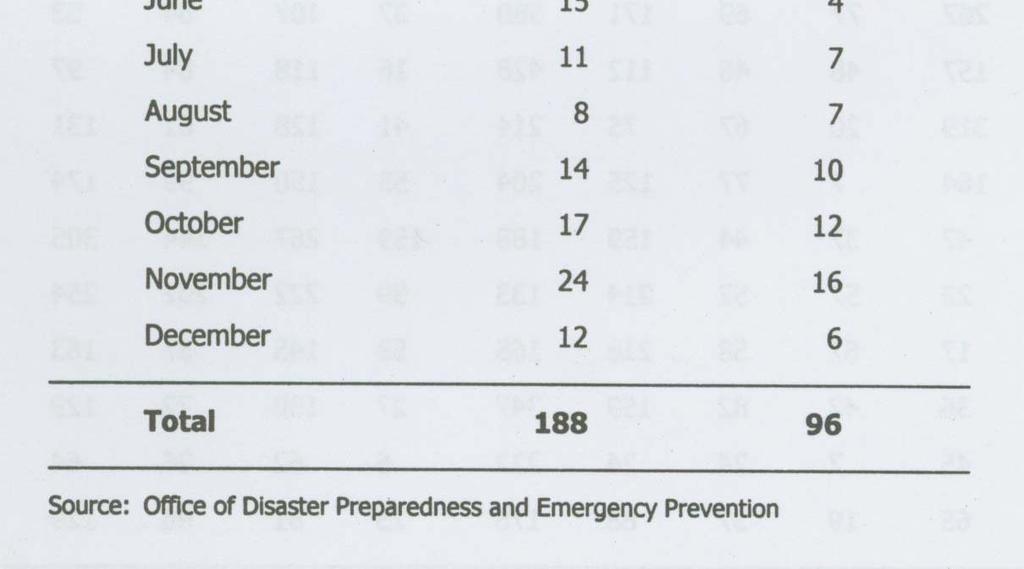
5 Top 10 Natural Disasters in Jamaica sorted by numbers of people killed and affected Source: The OFDA/CRED International Disaster Database. Oct Disaster Wind Storm Flood Wind Storm Flood Drought Wind Storm Earthquake Flood Flood Wind Storm Date 12-Sep May Sep Jun Nov Jan Apr May Aug-1980 Affected 810, , , , ,000 94,820 90,000 40,000 40,000 30,009
6 Disaster Date Killed Earthquake 14-Jan ,200 Flood 6-Jan Wind Storm 17-Aug Wind Storm 18-Nov Flood 18-Nov Flood 23-Nov Wind Storm 10-Aug Wind Storm 22-Sep Flood 15-May Flood 4-Nov

7
8 HIGH INCIDENCE OF HAZARDS IN JAMAICA IS DUE TO A COMBINATION OF SEVERAL GEOLOGICAL, GEOPHYSICAL, TECTONIC, AND GEOGRAPHIC FACTORS.
9 Plate tectonic setting
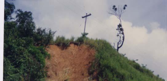
10
11


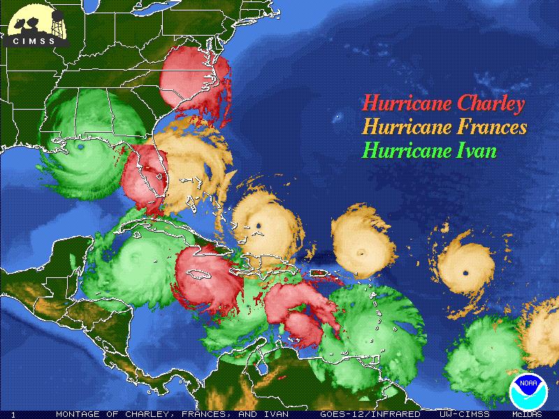
12 Storm surge, Harbour View: 10 September 2004
13 Natural hazards in the Caribbean From: Munich Re, 2002.

14
15 EM
16 Vertical Aerial Photograph of Liguanea Ridge
17 Irish Town Road Landslide 1988 ( Tyndale Biscoe Photo)

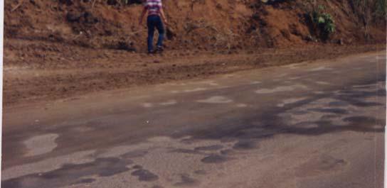


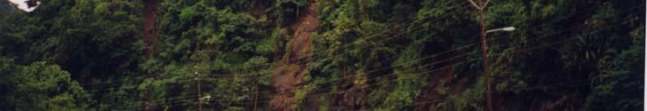
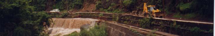
18 Landslides affecting roads, power lines, and domestic water supplies
19

20 Flood prone communities in Jamaica. Source: Water Resources Authority.

21


22 SPECTRUM OF HAZARD TYPES IN SMALL RIVER CHANNELS OF JAMAICA: sequence of competing events with decreasing gradient: debris slide or debris avalanche-debris flows- debris floods-floods. Population centres are located on debris fans developed along the interface of land and water- high liquefaction potential. Culverts and bridges located in debris flow segments must be designed to allow for the passage of rock debris and organic debris. Scale: Base of photo= Approx 1km. DEBRIS FLOW SEGMENT J.T. Biscoe Photo. DEBRIS FLOOD SEGMENT BLUEFIELDS 12 JUNE 1979 Caribbean Sea DEBRIS FAN


23 LANDSLIDES AND FLOODING IN HILLSIDE, ST. THOMAS, JAMAICA Rural community at Hillside was devastated by debris flows and debris floods in January Note the location of Hillside Primary School on a debris fan. Scale: Base of photo= Approx 1.2 km. LANDSLIDE AND DEBRIS FLOW SEGMENT Hillside Primary School Morant River Debris flood segment; Debris Fans. Hillside, St. Thomas, 27 January, Reproduced with permission of


24 DEBRIS FLOWS, June 1979 Flood rains, Bogue /Reading area

25 Debris flows, Blue Mountains, 12 September 1988.
26 Landslide and flooding processes in KMA:

27


28 Land degradation in Jamaica
.")
29 Landslides are the principal cause of land degradation and land productivity in the tropics including Jamaica. Landslide susceptibility in Clarendon and St. Catherine draped on a DEM (Unit for Disaster Studies, UWI & British Geological Survey Project completed in 2002). Red areas indicate high landslide susceptibility and also are sites of accelerated soil erosion. Efforts to correct land degradation and loss of land productivity should take into consideration rainfall-induced landslides.
30 EARLY WARNING SYSTEMS
31 RAINFALL INTENSITY-DURATION THRESHOLD FOR SHALLOW LANDSLIDES IN EASTERN JAMAICA: Using data for 19 storms, , a threshold relation between rainfall intensity-duration and landsliding was established Threshold for rainfall-induced shallow landslides in Eastern Jamaica ( ) 100 Rainfall Intensity (mm/hour) Rainfall Duration (hours) Rainfall events producing landslides ( ) Storms that did not cause landslides ( ) Rainfalls that caused landslides ( )
32 In Eastern Jamaica, rainfall threshold relation is defined for storms that had durations between hours and average rainfall intensities between 2-93 mm/h. The threshold relations reported here are reasonable first approximations. The threshold relation indicates that for rainfall of short duration (about 1 h): Intensities > 36 mm/h, are required to trigger landslides. These storms trigger mostly shallow landslides by causing an excess pore pressure in shallow colluvial zones. Such landslides were typically associated with type storms. Low average intensities of about 3mm/h appear to be sufficient to cause landslilding as storm duration approaches approximately 100 h. These triggered the largest, deepest landslides in eastern Jamaica, e.g., Flora, Gilbert, 2001 rainfall. Thresholds provide a key element of landslide warning system.
33 LANDSLIDE INTENSITY-DURATION RELATIONSHIP FOR HURRICANE GILBERT
34 Landslides are a gravity-induced natural erosional process through which hillslopes evolve and are triggered by both earthquakes and rainfall. They are distinct from simple gully erosion and sheet wash. The earthquakes of June 1692 and January 1907 and flood rains of June 1979 created hundreds of landslides which caused severe deforestation and erosion on the island. Threshold for earthquake-induced landslides in Jamaica.


35
36 Development in hazard prone areas
37
38
39
40 CONCLUSIONS
41 JAMAICA GEOSCAPE LANDSCAPE ELEMENTS AS NEOTECTONIC UNITS LIMESTONE PLATEAU WITH HILLS including the Cockpit country; 64% of the total land area; mainly in Cornwall and Middlesex, less in Surrey. Average annual rainfall cm. MOUNTAIN RANGES covering 22% of the total land area; mainly in the Blue Mountains, Port Royal Mountains, and the hilly interiors in the parishes of St. Andrew, St. Mary, St. Catherine, Clarendon, St. James, Hanover, and Westmorland. Average annual rainfall cm. COASTAL PLAINS, VALLEYS AND LAND- WATER INTERFACE covering 14% of the total land area; including areas under morass; plains of Liguanea, St. Catherine, Clarendon, Westmoreland, and Palisadoes tombolo. Average annual rainfall 190 cm. BEDROCK/ GEOTECHNICAL CHARACTERS Generally limestone, m.y. old; uplifted in the last 23 m.y. Bedrock is extensively fractured with joints and faults common. Basement rocks, 124 to 53 m.y. old; include lava flows, pyroclastic rocks, granodiorite, volcanically derived sediments, limestone, igneous and metamorphic rocks. Bedrock is intensively jointed, faulted, altered and deeply weathered. Post 11 m.y., marine and non-marine rocks and sediments, time span; volcanics, marls, clays, clastics, limestone, raised reefs; poorly consolidated gravels, sands, silts & clays of alluvial fans; mostly developed along south coast LANDSCAPE AND ACTIVE PROCESSES Elev m, Max. elev m, Blue Mts.; slopes > 25º; slopes > 30º; highly dissected; highly dissected; core of the island controlling karst ; water rainfall pattern; fault valleys accumulation Reproduced in and with fault permission scarps; surface of depressions; UDS. fault drainage; landslides. scarps; landslides. Alluvial /debris fans; sand dunes; raised reefs; poljes. Active coastal processes; liquefaction and submarine landslides.
42 WATER RESOURCES Limestone aquifers, provide 96% of groundwater; 3294 Mm 3 yr -1. Springs. Basement aquicludes; provide 665 Mm 3 yr -1 of water as surface runoff. Springs. Alluvium aquifers; provide 4% of the groundwater; 124 Mm 3 yr -1 LANDSLIDE SUSCEPTIBILITY Moderate to high. Generally very high. Low; submarine landslides. TROPICAL STORM /FLOODING STORM SURGE Very high/ high Very high/ high. Very high/ high. High. EARTHQUAKE HAZARDS LIQUEFACTION TSUNAMI High. High. High. Subject to liquefaction. High. EROSION RATES Moderate to high. Very high. Low to moderate. LIMESTONE PLATEAU WITH HILLS MOUNTAIN RANGES COASTAL PLAINS, VALLEYS AND LAND- WATER INTERFACE
43 Natural hazards in the Caribbean From: Munich Re, 2002.
44 ACKNOWLEDGEMENTS Grateful thanks are extended to Miss Deborah-Ann Rowe and Mr. Leonard Notice.
LAND DEGRADATION IN THE CARIBBEAN: QUATERNARY GEOLOGICAL PROCESSES. RAFI AHMAD
 EXTENDED TASK FORCE MEETING OF PARTICIPATING AGENCIES AND LATIN AMERICAN COUNTRIES FOR ENHANCING SOUTH-SOUTH COOPERATION BETWEEN LAC-CARIBBEAN SIDS PARTNERSHIP INITIATIVE ON LAND DEGRADATION AND SUSTAINABLE
INTRODUCTION. Climate
 INTRODUCTION Climate Landslides are serious natural disasters in many parts of the world. Since the past 30 years, rainfall triggered landslides and debris flows had been one of the natural disasters of
VULNERABILITY OF WATER SUPPLY TO NATURAL HAZARDS IN JAMAICA
 VULNERABILITY OF WATER SUPPLY TO NATURAL HAZARDS IN JAMAICA RAFI AHMAD rafi.ahmad@uwimona.edu.jm Unit for disaster studies, Department of Geography & Geology, The University of the West Indies, Mona Kingston
Was the Palisadoes ever an island? Will it become one in the future?
 The Island of the Palisadoes? Edward Robinson and Deborah-Ann Rowe Marine Geology Unit Department of Geography and Geology University of the West Indies Mona, Kingston 7, Jamaica mgu@uwimona.edu.jm Was
1.0 Introduction 1.1 Geographic Location 1.2 Topography 1.3 Climate and Rainfall 1.4 Geology and Hydrogeology 1.5 Water Availability 1.
 1.0 1.1 Geographic Location 1.2 Topography 1.3 Climate and Rainfall 1.4 Geology and Hydrogeology 1.5 Water Availability 1.6 Demography 1.0 1.1 Geographic Location St. Lucia forms part of an archipelago
Module 10: Resources and Virginia Geology Topic 4 Content: Virginia Geology Notes
 Virginia is composed of a very diverse landscape that extends from the beaches and barrier islands all of the way to the highly elevated Appalachian Plateau. Geologists have discovered ancient shallow
EROSION AND DEPOSITION
 CHAPTER 8 EROSION AND DEPOSITION SECTION 8 1 Changing Earth s Surface (pages 252-255) This section explains how sediment is carried away and deposited elsewhere to wear down and build up Earth s surface.
Unit 7.2 W.E.D. & Topography Test
 Name: Score: Unit 7.2 W.E.D. & Topography Test 1. 2. 3. 4. 5. 6. 7. 8. 9. 10. 11. 12. 13. 14. 15. 16. 17. 18. 19. 20. 21. 22. 23. 24. 25. 1. The formation of mountains is due mainly to while the destruction
Debris flow: categories, characteristics, hazard assessment, mitigation measures. Hariklia D. SKILODIMOU, George D. BATHRELLOS
 Debris flow: categories, characteristics, hazard assessment, mitigation measures Hariklia D. SKILODIMOU, George D. BATHRELLOS Natural hazards: physical phenomena, active in geological time capable of producing
b Blackwell Science Environmental Geology PRINCIPLES AND PRACTICE
 Environmental Geology PRINCIPLES AND PRACTICE Fred G. Bell Department of Geology and Applied Geology University of Natal, Durban, South Africa b Blackwell Science Preface, ix 1 Introduction, 1 1.1 Planning
UNIT 11 SOUTH ASIA SG 1 - PHYSICAL GEOGRAPHY & THE ENVIRONMENT
 UNIT 11 SOUTH ASIA SG 1 - PHYSICAL GEOGRAPHY & THE ENVIRONMENT I. PHYSICAL GEOGRAPHY TAKE OUT YOUR PHYSICAL MAP OF SOUTH ASIA A. The Himalayan Mountains form the northern boundary of the region (color
OIKOS > landslide > mechanism >predisposing causes
 predisposing causes and trigger OIKOS > landslide > mechanism >predisposing causes Landslides are events that occur in space and time. As such, it is usually possible to identify both one or more landslide
Name. 4. The diagram below shows a soil profile formed in an area of granite bedrock. Four different soil horizons, A, B, C, and D, are shown.
 Name 1. In the cross section of the hill shown below, which rock units are probably most resistant to weathering? 4. The diagram below shows a soil profile formed in an area of granite bedrock. Four different
Major External Processes Driven by energy from the sun and from gravity. Also create hazards and resources.
 Geologic Processes and Hazards Definition of Geology External and Internal Processes: examples of each Fundamentals of Plate Tectonics: definition, types of boundaries, general geography, hazards & resources
Using Weather and Climate Information for Landslide Prevention and Mitigation
 Using Weather and Climate Information for Landslide Prevention and Mitigation Professor Roy C. Sidle Disaster Prevention Research Institute Kyoto University, Japan International Workshop on Climate and
GLG101: What-To-Know List
 Exam 3, Page 1 GLG101: What-To-Know List (Derived from Before You Leave This Page Lists) This list is intended to guide your reading and to help you prepare for the online multiple-choice quizzes. Each
5.2 IDENTIFICATION OF HAZARDS OF CONCERN
 5.2 IDENTIFICATION OF HAZARDS OF CONCERN To provide a strong foundation for mitigation actions considered in Sections 6 and 9, County focused on considering a full range of s that could impact area, and
Need of Proper Development in Hilly Urban Areas to Avoid
 Need of Proper Development in Hilly Urban Areas to Avoid Landslide Hazard Dr. Arvind Phukan, P.E. Cosultant/Former Professor of Civil Engineering University of Alaska, Anchorage, USA RI District Governor
GEOTECHNICAL ENGINEERING INVESTIGATION HANDBOOK Second Edition
 GEOTECHNICAL ENGINEERING INVESTIGATION HANDBOOK Second Edition Roy E. Hunt Taylor & Francis Taylor & Francis Croup Boca Raton London New York Singapore A CRC title, part of the Taylor & Francis imprint,
Assessing Hazards and Risk
 Page 1 of 6 EENS 204 Tulane University Natural Disasters Prof. Stephen A. Nelson Assessing Hazards and Risk This page last updated on 07-Jan-2004 As discussed before, natural disasters are produced by
International Journal of Modern Trends in Engineering and Research e-issn No.: , Date: April, 2016
 International Journal of Modern Trends in Engineering and Research www.ijmter.com e-issn No.:2349-9745, Date: 28-30 April, 2016 Landslide Hazard Management Maps for Settlements in Yelwandi River Basin,
Geomorphology and Landslide Hazard Models
 Geomorphology and Landslide Hazard Models Steve Parry GeoRisk Solutions Key component of interpreting geomorphology and therefore hazard at a site is the use of API The purpose of this talk is not to try
GLG Chapter 7 Sedimentary Environments & Rocks
 GLG 101 - Chapter 7 Sedimentary Environments & Rocks Name Note, Oct 11: I ll be writing this study sheet over the next few days. Each day I will add questions until the entire chapter is done, hopefully
Beyond the Book. FOCUS Book
 FOCUS Book Suppose your city wants to build a new housing development on a steep slope outside town. Design a model to test whether the land is safe from the types of landslides you read about in this
Special edition paper
 Development of a System for Natural Disaster Risk Factor Evaluation by the EADaS Method Ryuji Oshima* Asako Togari* Masahiko Tomori* Natural disasters of a variety of scales occur along railway lines,
New A-Level Physical Geography
 Half Term 1 3.1 Physical Geography: 3.1.5 Hazards: Plate Tectonics This optional section of our specification focuses on the lithosphere and the atmosphere, which intermittently but regularly present natural
Unit 4: Landscapes Practice Problems
 Name: Date: 1. Soil with the greatest porosity has particles that are A. poorly sorted and densely packed B. poorly sorted and loosely packed C. well sorted and densely packed D. well sorted and loosely
Environmental Geology
 F O U R T H E D I T I O N Introduction to Environmental Geology Edward A. Keller University of California, Santa Barbara PEARSON Prentice Hall Pearson Education International CONTENTS Preface xiii PART
NATURAL HAZARDS ENVIRONMENT OF THE CARIBBEAN: AN OVERVIEW OF ACTIVE PROCESSES
 NATURAL HAZARDS ENVIRONMENT OF THE CARIBBEAN: AN OVERVIEW OF ACTIVE PROCESSES RAFI AHMAD rafi.ahmad@uwimona.edu.jm UNIT FOR DISASTER STUDIES http://www.mona.uwi.edu.jm/uds/ DEPARTMENT OF GEOGRAPHY & GEOLOGY
MODELLING FROST RISK IN APPLE TREE, IRAN. Mohammad Rahimi
 WMO Regional Seminar on strategic Capacity Development of National Meteorological and Hydrological Services in RA II (Opportunity and Challenges in 21th century) Tashkent, Uzbekistan, 3-4 December 2008
Fresh Water: Streams, Lakes Groundwater & Wetlands
 Fresh Water:, Lakes Groundwater & Wetlands Oct 27 Glaciers and Ice Ages Chp 13 Nov 3 Deserts and Wind and EXAM #3 Slope hydrologic cycle P = precip I = precip intercepted by veg ET = evapotranspiration
Bell Ringer. Are soil and dirt the same material? In your explanation be sure to talk about plants.
 Bell Ringer Are soil and dirt the same material? In your explanation be sure to talk about plants. 5.3 Mass Movements Triggers of Mass Movements The transfer of rock and soil downslope due to gravity is
Objectives: Define Relative Age, Absolute Age
 S6E5. Students will investigate the scientific view of how the earth s surface is formed. c. Classify rocks by their process of formation. g. Describe how fossils show evidence of the changing surface
Pre-Lab Reading Questions ES202
 ES202 The are designed to encourage students to read lab material prior to attending class during any given week. Reading the weekly lab prior to attending class will result in better grade performance
Physical Geography: Patterns, Processes, and Interactions, Grade 11, University/College Expectations
 Geographic Foundations: Space and Systems SSV.01 explain major theories of the origin and internal structure of the earth; Page 1 SSV.02 demonstrate an understanding of the principal features of the earth
Erosion and Deposition
 Erosion and Deposition Erosion Sediment natural forces move rock/soil from one place to another. gravity, water, wind, glaciers, waves are causes material moved by erosion Deposition when erosion lays
Ch 10 Deposition Practice Questions
 1. Base your answer to the following question on the data table below. Six identical cylinders, A through F, were filled with equal volumes of sorted spherical particles. The data table shows the particle
Landslide & Coastal Erosion Risk Reduction at Oregon s Water/Wastewater Networks
 Landslide & Coastal Erosion Risk Reduction at Oregon s Water/Wastewater Networks Laura Gabel, RG (with Bill Burns, RG & Jonathan Allan, Ph. D) Oregon Department of Geology and Mineral Industries (541)
Grade 5 Hands on Science Weathering, Erosion and Deposition
 Grade 5 Hands on Science Weathering, Erosion and Deposition Objective: To demonstrate and investigate the effect of weathering, water and wind erosion and the subsequent deposition into landforms. Background:
Chapter 11 10/30/2013. Mass Wasting. Introduction. Factors That Influence Mass Wasting. Introduction. Factors That Influence Mass Wasting
 Introduction Chapter 11 Mass wasting - The downslope movement of material resulting from the force of gravity. Mass Wasting Mass wasting results when the force of gravity acting on a slope exceeds the
Downloaded from Downloaded from
 IV SEMESTER BACK-PAPER EXAMINATION-2004 Q. [1] [a] Describe internal structure of the earth with a neat sketch. Write down the major land forms and their characteristics on the earth surface. [8] [b] What
PALEOGEOGRAPHY of NYS. Definitions GEOLOGIC PROCESSES. Faulting. Folding 9/6/2012. TOPOGRAPHIC RELIEF MAP of NYS GRADATIONAL TECTONIC
 TOPOGRAPHIC RELIEF MAP of NYS PALEOGEOGRAPHY of NYS Prof. Anthony Grande AFG 2012 Definitions GEOLOGIC PROCESSES Geography: study of people living on the surface of the earth. Geology: the scientific study
Term Knowledge Using and applying Grade Criteria Autumn 1 Assessment window October Natural hazards pose major risks to people and property.
 Assessment Schedule Year 9 2015/6 Term Knowledge Using and applying Grade Criteria Autumn 1 Assessment window October 2015 3.1.1.2 Tectonic Natural hazards pose major risks to people and property. Definition
Mass Wasting: The Work of Gravity
 Chapter 15 Lecture Earth: An Introduction to Physical Geology Twelfth Edition Mass Wasting: The Work of Gravity Tarbuck and Lutgens Chapter 15 Mass Wasting The Importance of Mass Wasting Slopes are the
5.2. IDENTIFICATION OF NATURAL HAZARDS OF CONCERN
 5.2. IDENTIFICATION OF NATURAL HAZARDS OF CONCERN To provide a strong foundation for mitigation strategies considered in Sections 6 and 9, County considered a full range of natural hazards that could impact
water erosion lithosphere Describe the process of erosion and deposition. chemical weathering Dissolving limestone is an example of.
 At one time, there was one large island off the coast of Mississippi and now it is two separate islands. What caused the island to be split into two? water erosion The crust and the top part of the upper
Fukien Secondary School Monthly Vocabulary/Expression List for EMI Subjects Secondary Two. Subject: Geography
 Focus: General Specific : Section Two : Unit One 1 Landslide 2 Downslope movement 3 Rock 4 Soil 5 Gravity 6 Natural hazard 7 Rainwater 8 Friction 9 Hilly relief 10 Unstable 11 Season 12 Saturated 13 Construction
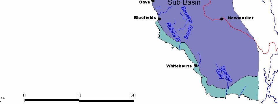
BLUEFIELDS EMERGENCY PLATFORM:
 BLUEFIELDS EMERGENCY PLATFORM: Community Early Warning Systems for Mitigating Hydro-Meteorological Impacts in Bluefields, Jamaica T. Hyman, J. Horney, B. Carby, K. Miller, M. Taylor OUTLINE Background
USGS scientists with Venezuelan military liaisons.
 USGS scientists with Venezuelan military liaisons. In December, 1999, heavy rainfall triggered thousands of debris flows and caused numerous flash floods in a 300- kilometer long area of the north coast
STREAM SYSTEMS and FLOODS
 STREAM SYSTEMS and FLOODS The Hydrologic Cycle Precipitation Evaporation Infiltration Runoff Transpiration Earth s Water and the Hydrologic Cycle The Hydrologic Cycle The Hydrologic Cycle Oceans not filling
Precipitation Evaporation Infiltration Earth s Water and the Hydrologic Cycle. Runoff Transpiration
 STREAM SYSTEMS and FLOODS The Hydrologic Cycle Precipitation Evaporation Infiltration Earth s Water and the Hydrologic Cycle Runoff Transpiration The Hydrologic Cycle The Hydrologic Cycle Oceans not filling
TAKE HOME EXAM 8R - Geology
 Name Period Date TAKE HOME EXAM 8R - Geology PART 1 - Multiple Choice 1. A volcanic cone made up of alternating layers of lava and rock particles is a cone. a. cinder b. lava c. shield d. composite 2.
Holocene evolution of Dahab coastline Gulf of Aqaba, Sinai Peninsula, Egypt 1
 Holocene evolution of Dahab coastline Gulf of Aqaba, Sinai Peninsula, Egypt 1 Magdy Torab* 2 * Prof. of Geomorphology, Department of Geography, Damanhour University, Egypt 3 E-mail: magdytorab@hotmail.com.
Workshop on Drought and Extreme Temperatures: Preparedness and Management for Sustainable Agriculture, Forestry and Fishery
 Workshop on Drought and Extreme Temperatures: Preparedness and Management for Sustainable Agriculture, Forestry and Fishery 16-17 Feb.2009, Beijing, China Modeling Apple Tree Bud burst time and frost risk
GG101 Lecture 22: Mass Wasting. Soil, debris, sediment, and broken rock is called regolith.
 GG101 Lecture 22: Mass Wasting Mass Wasting is the movement of rock and soil down a slope due to the force of gravity. Soil, debris, sediment, and broken rock is called regolith. Mass wasting creates broad
Earthquake hazards. Aims 1. To know how hazards are classified 2. To be able to explain how the hazards occur 3. To be able to rank order hazards
 Earthquake hazards Aims 1. To know how hazards are classified 2. To be able to explain how the hazards occur 3. To be able to rank order hazards Types of hazard Primary A direct result of the earthquake
5.2 IDENTIFICATION OF HAZARDS OF CONCERN
 5.2 IDENTIFICATION OF HAZARDS OF CONCERN 2015 HMP Update Changes The 2010 HMP hazard identification was presented in Section 6. For the 2015 HMP update, the hazard identification is presented in subsection
Science EOG Review: Landforms
 Mathematician Science EOG Review: Landforms Vocabulary Definition Term canyon deep, large, V- shaped valley formed by a river over millions of years of erosion; sometimes called gorges (example: Linville
Geography Class XI Fundamentals of Physical Geography Section A Total Periods : 140 Total Marks : 70. Periods Topic Subject Matter Geographical Skills
 Geography Class XI Fundamentals of Physical Geography Section A Total Periods : 140 Total Marks : 70 Sr. No. 01 Periods Topic Subject Matter Geographical Skills Nature and Scope Definition, nature, i)
Climate Change Impacts and Adaptation for Coastal Transport Infrastructure in Caribbean SIDS
 UNCTAD National Workshop Saint Lucia 24 26 May 2017, Rodney Bay, Saint Lucia Climate Change Impacts and Adaptation for Coastal Transport Infrastructure in Caribbean SIDS Impacts of Natural Hazards on the
Gateway Trail Project
 Gateway Trail Project Debris Flow Hazard Assessment By: Juan de la Fuente April 30, 2010 Background- On April 22, 2010, the Shasta-Trinity National Forest (Mt. Shasta-McCloud Unit) requested a geologic
4. The map below shows a meandering stream. Points A, B, C, and D represent locations along the stream bottom.
 1. Sediment is deposited as a river enters a lake because the A) velocity of the river decreases B) force of gravity decreases C) volume of water increases D) slope of the river increases 2. Which diagram
A Preliminary Geophysical Reconnaissance Mapping of Emirau Ground Water Resource, Emirau Island, New Ireland Province, PNG
 A Preliminary Geophysical Reconnaissance Mapping of Emirau Ground Water Resource, Emirau Island, New Ireland Province, PNG Geological Survey Division of Mineral Resources Authority (MRA) Papua New Guinea
Level 1/Level 2 Certificate Specimen Paper
 Centre Number Surname Other Names Candidate Number For Examiner s Use Examiner s Initials Candidate Signature Geography 8031/1 Dynamic Physical World For this paper you must have: the colour insert (enclosed).
NORTH VISTA SECONDARY SCHOOL HUMANITIES DEPARTMENT SECONDARY 3 EXPRESS HUMANITIES (GEOGRAPHY) 2272/02 CONTENT OUTLINE Term 1
 2272/02 CONTENT OUTLINE Term 1") NORTH VISTA SECONDARY SCHOOL HUMANITIES DEPARTMENT SECONDARY 3 EXPRESS HUMANITIES (GEOGRAPHY) 2272/02 CONTENT OUTLINE 2019 Term 1 Week Learning Outcomes Skills to be covered Assignment Test Project 1-2
NORTH VISTA SECONDARY SCHOOL HUMANITIES DEPARTMENT SECONDARY 3 EXPRESS HUMANITIES (GEOGRAPHY) 2272/02 CONTENT OUTLINE 2019 Term 1 Week Learning Outcomes Skills to be covered Assignment Test Project 1-2
They include earthquakes, volcanic eruptions, floods, landslides, and other processes and occurrences. They are included in the broader concept of.
 They include earthquakes, volcanic eruptions, floods, landslides, and other processes and occurrences. They are included in the broader concept of. In general, natural processes are labeled hazardous only
Chapter 5: Glaciers and Deserts
 I. Glaciers and Glaciation Chapter 5: Glaciers and Deserts A. A thick mass of ice that forms over land from the compaction and recrystallization of snow and shows evidence of past or present flow B. Types
TECHNIQUES FOR ASSESSING COASTAL HAZARD AREAS FOR THE GISBORNE DISTRICT COAST
 TECHNIQUES FOR ASSESSING COASTAL HAZARD AREAS FOR THE GISBORNE DISTRICT COAST July 1994 C.R. 1994/12 Jeremy G Gibb 2009 All rights reserved. This work is entitled to the full protection given by the Copyright
After 2017 Is the Future Predictable?
 After 2017 Is the Future Predictable? Presented by: Evan Thompson Director, Meteorological Service, Jamaica At Caribbean Insurance Conference, Montego Bay, Jamaica June 4, 2018 What s Happening with the
Flooding and Development in Low-Lying areas in Jamaica : Impact of Climate Change
 Flooding and Development in Low-Lying areas in Jamaica : Impact of Climate Change Session : Managing Ecosystmes for more Resilient Cities in India, Bolivia, Jamaica Resilient Cities, 2016, Bonn Arpita
 Page 1 of 9 Name: Base your answer to the question on the diagram below. The arrows show the direction in which sediment is being transported along the shoreline. A barrier beach has formed, creating a
Laboratory Exercise #4 Geologic Surface Processes in Dry Lands
 Page - 1 Laboratory Exercise #4 Geologic Surface Processes in Dry Lands Section A Overview of Lands with Dry Climates The definition of a dry climate is tied to an understanding of the hydrologic cycle
1. Erosion by Running Water Most powerful cause of erosion
 I. Destructive Forces Notes: Destructive force: a process in which land is destroyed or changed such as weathering and erosion. All landforms are a result of a combination of constructive and destructive
Environmental Geology Lab 5 - Mass Wasting Hazards
 Environmental Geology Lab 5 - Mass Wasting Hazards page - 1 Many landslides, slope failures or sinkholes (collapse structures formed in terrain underlain by limestone rocks) occur during or immediately
RIVERS, GROUNDWATER, AND GLACIERS
 RIVERS, GROUNDWATER, AND GLACIERS Delta A fan-shaped deposit that forms when a river flows into a quiet or large body of water, such as a lake, an ocean, or an inland sea. Alluvial Fan A sloping triangle
2014 Summer training course for slope land disaster reduction Taipei, Taiwan, Aug
 MINISTRY OF SCIENCE AND TECHNOLOGY HYDROTECH RESEARCH INSTITUTE MINISTRY OF NATURAL RESOURCES AND ENVIRONMENT VIETNAM INSTITUTE OF GEOSCIENCES AND MINERAL RESOURCES (VIGMR) 2014 Summer training course
Miami-Dade College. The student will demonstrate a basic knowledge of the origin and evolution of the Earth and its planetary environment.
 Miami-Dade College Common Course Number: GLY 3884 Course Title: Environmental Geology Catalog Course Description: This course focuses on the study of the application of geology to the interactions between
Mass Wasting. Revisit: Erosion, Transportation, and Deposition
 Mass Wasting Revisit: Erosion, Transportation, and Deposition While landslides are a normal part of erosion and surface processes, they can be very destructive to life and property! - Mass wasting: downslope
Preliminaries to Erosion: Weathering and Mass Wasting
 Preliminaries to Erosion: Weathering & Mass Wasting All things deteriorate in time. Virgil 1 Preliminaries to Erosion: Weathering and Mass Wasting Denudation The Impact of Weathering and Mass Wasting on
WATER ON AND UNDER GROUND. Objectives. The Hydrologic Cycle
 WATER ON AND UNDER GROUND Objectives Define and describe the hydrologic cycle. Identify the basic characteristics of streams. Define drainage basin. Describe how floods occur and what factors may make
Eagle Creek Post Fire Erosion Hazard Analysis Using the WEPP Model. John Rogers & Lauren McKinney
 Eagle Creek Post Fire Erosion Hazard Analysis Using the WEPP Model John Rogers & Lauren McKinney Columbia River Gorge at Risk: Using LiDAR and GIS-based predictive modeling for regional-scale erosion susceptibility
Natural Disasters. in Florida. Severe Thunderstorms
 Natural Disasters in Florida SC.6.E.7.7 Investigate how natural disasters have affected human life in Florida. Severe Thunderstorms While the typical afternoon thunderstorm in Florida may not appear to
8 Current Issues and Research on Sediment Movement in the River Catchments of Japan
 8 Current Issues and Research on Sediment Movement in the River Catchments of Japan YUTAKA ICHIKAWA INTRODUCTION Prediction of sediment movement is one of the challenging tasks in water-related research.
WHAT IS THE EARTH MADE OF? LITHOSPHERE AND HYDROSPHERE
 UNIT 8 WHAT IS THE EARTH MADE OF? LITHOSPHERE AND HYDROSPHERE TABLE OF CONTENTS 1 THE STRUCTURE OF THE EARTH... 2 2 THE FORMATION OF THE RELIEF: INTERNAL AND EXTERNAL FORCES.... 2 2.1 Internal forces:
Mass Movements, Wind, and Glaciers
 Mass Movements,, and Glaciers SECTION 8.1 Mass Movement at Earth s Surface In your textbook, read about mass movement. Use each of the terms below just once to complete the passage. avalanche creep landslide
Down-stream process transition (f (q s ) = 1)
 = 1)") Down-stream process transition (f (q s ) = 1) Detachment Limited S d >> S t Transport Limited Channel Gradient (m/m) 10-1 Stochastic Variation { Detachment Limited Equilibrium Slope S d = k sd A -θ d S
Down-stream process transition (f (q s ) = 1) Detachment Limited S d >> S t Transport Limited Channel Gradient (m/m) 10-1 Stochastic Variation { Detachment Limited Equilibrium Slope S d = k sd A -θ d S
Which map shows the stream drainage pattern that most likely formed on the surface of this volcano? A) B)
 B)") 1. When snow cover on the land melts, the water will most likely become surface runoff if the land surface is A) frozen B) porous C) grass covered D) unconsolidated gravel Base your answers to questions
1. When snow cover on the land melts, the water will most likely become surface runoff if the land surface is A) frozen B) porous C) grass covered D) unconsolidated gravel Base your answers to questions
Environmental Science Institute The University of Texas - Austin
 Environmental Science Institute The University of Texas - Austin Geologic Wonders of Central Texas Dr. Leon Long This file contains suggestions for how to incorporate the material from this CDROM into
Terrain Units PALEOGEOGRAPHY: LANDFORM CREATION. Present Geology of NYS. Detailed Geologic Map of NYS
 NYS TOPOGRAPHY Why so? PALEOGEOGRAPHY: LANDFORM CREATION Prof. Anthony Grande AFG 014 Present Geology of NYS Detailed Geologic Map of NYS Generalized Geology Detailed Geology Hot links to the fold out
Landforms in Canada. Canada is made up of three dis;nct types of landforms: Canadian Shield Highlands Lowlands
 Canada s Landforms What is a Landform? A landform is any physical feature of the Earth s surface having a characteris;c, recognizable shape, produced by natural causes. Landforms include major features
THE SCIENCE OF MAPS. ATL Skill: Critical thinking - Use models and simulations to explore complex systems and issues
 THE SCIENCE OF MAPS 8.9C interpret topographic maps and satellite views to identify land and erosional features and predict how these features may be reshaped by weathering ATL Skill: Critical thinking
PHYSICAL GEOGRAPHY: An overview. Definitions. Faulting. Folding GEOLOGIC PROCESSES 9/17/2013 TOPOGRAPHIC RELIEF
 TOPOGRAPHIC RELIEF PHYSICAL GEOGRAPHY: An overview Prof. Anthony Grande AFG 0913 2 Definitions GEOLOGIC PROCESSES Geography: Study of people living on the surface of the earth. Geology: the study of the
Landslide Susceptibility Maps for the Kingston Metropolitan Area, Jamaica with Notes on Their Use
 Page 1 of 25 Landslide Susceptibility Maps for the Kingston Metropolitan Area, Jamaica with Notes on Their Use Organization of American States General Secretariat Unit for Sustainable Development and Environment
Pratice Surface Processes Test
 1. The cross section below shows the movement of wind-driven sand particles that strike a partly exposed basalt cobble located at the surface of a windy desert. Which cross section best represents the
Changing Earth s Surface
 Name Date Class Changing Earth s Surface What processes wear down and build up Earth s surface? What causes the different types of mass movement? Erosion is the process by which natural forces move weathered
MASS MOVEMENTS, WIND, AND GLACIERS
 Date Period Name MASS MOVEMENTS, WIND, AND GLACIERS SECTION.1 Mass Movements In your textbook, read about mass movements. Use each of the terms below just once to complete the passage. avalanche creep
The boulder was most likely moved to this location by A) glacial ice B) prevailing wind C) streamfiow D) volcanic action
 glacial ice B) prevailing wind C) streamfiow D) volcanic action") 1. Which rock material was most likely transported to its present location by a glacier? A) rounded sand grains found in a river delta B) rounded grains found in a sand dune C) residual soil found on a
1. Which rock material was most likely transported to its present location by a glacier? A) rounded sand grains found in a river delta B) rounded grains found in a sand dune C) residual soil found on a
Revealing the interaction between Society and Nature. DesInventar, disaster inventories for damage and loss assessment
 UNFCCC Regional expert meeting on a range approaches to address loss and damage associated with the adverse effects climate change, including impacts related to extreme weather events and slow onset events
COURSE OUTLINE GEOLOGY 101, Sec 002 Fall 2008, Diecchio Text: Lutgens, Tarbuck and Tasa, Essentials of Geology, 10 th edition
 COURSE OUTLINE GEOLOGY 101, Sec 002 Fall 2008, Diecchio Text: Lutgens, Tarbuck and Tasa, Essentials of Geology, 10 th edition Overview Of Earth ch 1 Earth's place in solar system, galaxy, universe Atmosphere,
Prepared By: John Blair Sean Donahue Celeste Hoffman Kimberly Klinkers Megan Slater
 Prepared By: John Blair Sean Donahue Celeste Hoffman Kimberly Klinkers Megan Slater Green River Basin Location Green River Basin Stratigraphic Correlation Chart showing Study Map Units Sample of Existing