Using Earth Observation Data for Monitoring River Basins
|
|
|
- Ruby Gordon
- 5 years ago
- Views:
Transcription

1 Using Earth Observation Data for Monitoring River Basins The NBI Experience By Milly Mbuliro GIS/ Remote Sensing Specialist Nile Basin Initiative Secretariat NBDF, 23 rd -25 th October, Kigali Convention Center, Kigali, Rwanda

2 NBI: Overview The Nile Basin Initiative (NBI) is a regional intergovernmental Partnership among 10 countries. Objective is to Promote sustainable utilization of the Nile Basin resources. It is our Mandate to Monitor the status of the basin to promote informed evidence - based decision making SOUTH SUDAN D R CONGO UGANDA RWANDA BURUNDI EGYPT SUDAN ETHIOPIA KENYA TANZANIA
 Spatial and Temporal variation in its processes.")


3 The Nile Basin The Nile cuts across diverse climatic zones (humid to arid conditions) Spatial and Temporal variation in its processes. Highest population growth rates in the region. Each riparian state has development master plans ( irrigation master plan, Energy master plan etc Leading to increased need and pressure on the finite resources. Faces environmentally related challenges such as floods, Land degradation, surface water pollution, sediment load and others


4 Fundamental questions Is the Nile basin water Secure? Is Climate change a real threat to the Nile basin region? How much water is available to meet the demand Are our resources sustainable? What will be the status years after and how was it years before? Is there any potential for development? Untapped potential You can not manage what you can not measure; That is why we monitor

5 NBI Response The NBI informs and provides a platform for dialogue over such issues through Strategic Analysis and group discussions Preparation of periodic state of River Nile Basin Reports, first one in 2012, next issue in 2018 Under the Hydro-Met project, the NBI aims to set up a regionally recognized monitoring system to capture and store readings of key climatic variable. Design stage, agreed upon by countries already completed, looking for funds to implement the regional monitoring System in phases The proposed regional system comprises of ground measurements and satellite based measurements
6 Basin Monitoring NBI promotes good data management, data sharing and data communication to resource managers in a consistent, harmonized and understandable way Variables monitored include Rainfall, Evapotranspiration, Relative Humidity, Land and Air Temperature, Water levels, Soil erosion Vulnerability, Land-cover /use change, Seasonal Variation of Wetland areas, Soil Moisture, Vegetation cover and socio economic indicators among others.

7 Nile Basin Rainfall Monitored by both observed and satellite data Data Products are mainly TRMM 3B43v7 monthly product and the 3B42 daily product. Other rainfall data products include CRU_TS, from the Climatic research unit (includes rain-guage data Chirps, RFE from the NOAA. A comparison of how the different products estimate rainfal over the different subbasins was made Analysis to compare with ground measurements is ongoing

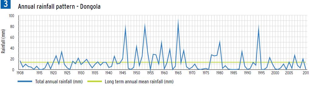
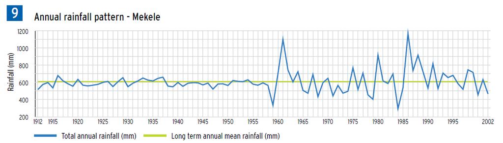
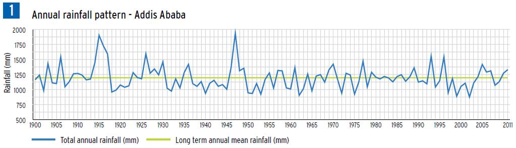
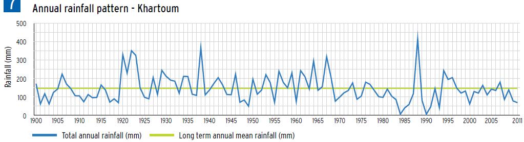
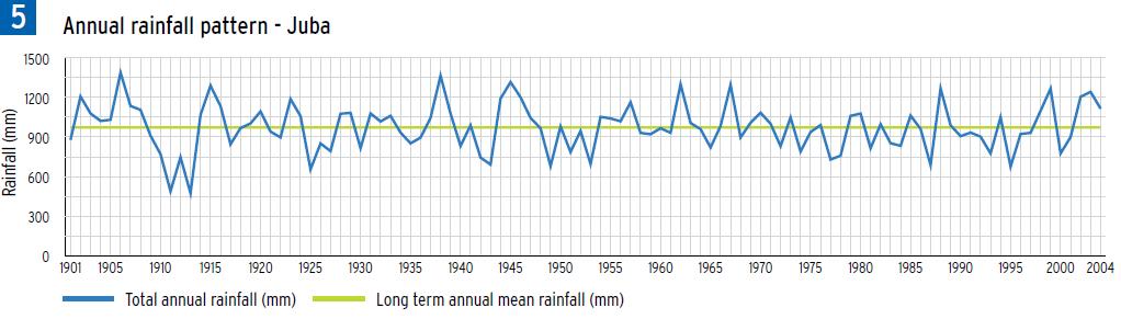
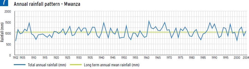
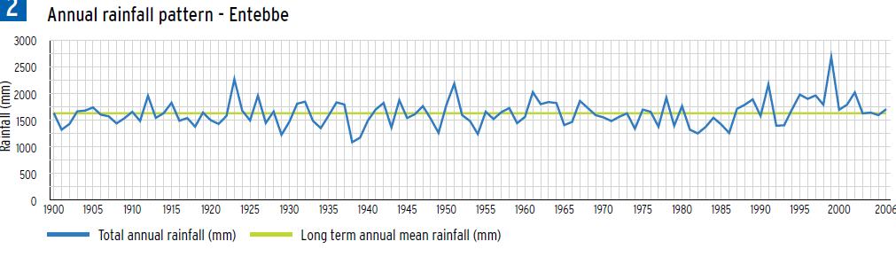
8 Nile Basin Rainfall-Annual Find more in the Nile Basin Water Resources Atlas

9 Nile Basin Rainfall- Comparative assessment Baro- Akobbo- Sobat Subbasin Lake Victoria Subbasin
10 Nile Basin Rainfall- Comparative assessment Bahr el Jebel Subbasin Lake Albert Subbasin
11 Nile Basin Rainfall- Comparative assessment Blue Nile Subbasin Main Nile Subbasin

12 Actual Evapotranspiration ET is an important component of the water balance Is the only consumer of water Water balance models were used to estimate ET as the remainder after determining all other balance components Now, Satellite based techniques have emerged NBI has generated Actual Evapotransipiration estimates over Nile Basin Countries based on MOD16ET Spatial resolution;1km cell size Temporal resolution is 8 days, monthly and annual


13 Actual Evapotranspiration The data shows Temporal and spatial variation over the Nile Basin. ET accounts for 87% of basin rainfall There is variation even at sub-basin level Highest in the Nile Equatorial lakes region due to moisture availability


14 Sample analyses ET: ETo ratio gives an indication of moisture availability Highest ET/ETo ratio occurs in the Lake Albert Sub basin and the Sudd area Lowest ET:ETo is found in the Main Nile and Tekeze Atbara Subbasin which are mostly dry. Ratio of ET:P shows the conversion rate of available moisture to evapotranspiration When ratio is less than 1 there is potential for generation of runoff or recharge ground water When ratio is more than 1, all the rainfall and water coming in through the river is lost as AET


15 Products 11 Long Term and Seasonal Variation of Wetlands. Small water body mapping in the Sudd region Based on Sentineldata Uses soil moisture retrieval technique


16 Other water quality indicators that can be measured from satellite data include: TDS Lake Surface Temperature And others White regions show no data From this analysis, point source contamination can be identified


17 Flood mapping Flood prone areas Threshold classification Historical flood mapping Data requirements ENVISAT ASAR data Erosion potential / Vulnerability Soil erosion Potential Hot Spot Detection Data Requirements NOAA RFE Rainfall data FAO Soils SRTM DEM ESA GlobCover Landcover


18 Knowledge Products Nile Basin Water Resources Atlas State of River Nile Basin Report MSIOA reports Understanding Nile Basin Hydrology: Mapping Actual evapo-transipiration over Nile basin countries Visit for more publications
19 Implications for River Basin management You can not manage what you can not measure or monitor. In view of all country development master plans, monitoring is a must Satellite data has been recognised as a feasible technique for monitoring a wide range of earth processes. Satellite data and techniques keep evolving, so should resource managers. River basins like the Nile basin with ungauged catchments/limited ground observations need EO data. Data management and sharing are key components for river basin management and this calls for regional cooperation. NBI offers such a platform where transboundary data can be shared. NBI has designed a regional hydromet system (with a component on EO data) with all key stakeholders consulted, agreed upon by countries and awaits implementation. Use of Earth Observation data is encouraged to compliment ground observations for River basin monitoring/management
20 THANK YOU Milly Mbuliro
Sedimentation in the Nile River
 Advanced Training Workshop on Reservoir Sedimentation Sedimentation in the Nile River Prof. Dr. Abdalla Abdelsalam Ahmed 10-16 Oct. 2007, IRTCES, Beijing, China CWR,Sudan 1 Water is essential for mankind
TIGER-NET Newsletter. The TIGERNET Newsletter Issue 2 November
 Content TIGER-NET Newsletter Requirements Engineering Review Meeting The role of the users in Tiger NET TIGER NET at AARSE conference Progress of system development Progress of product development 2 Welcome
Applying Earth System Forecasts For Climate Change To Inform Conservation Planning Of The East African Great Lakes
 Applying Earth System Forecasts For Climate Change To Inform Conservation Planning Of The East African Great Lakes S. Asefi, D. Lawrence, P. Lawrence, A. Seimon, S. Talbot 1- University Of Virginia Department
How to integrate wetland processes in river basin modeling? A West African case study
 How to integrate wetland processes in river basin modeling? A West African case study stefan.liersch@pik-potsdam.de fred.hattermann@pik-potsdam.de June 2011 Outline Why is an inundation module required?
Transboundary water management with Remote Sensing. Oluf Jessen DHI Head of Projects, Water Resources Technical overview
 Transboundary water management with Remote Sensing Oluf Jessen DHI Head of Projects, Water Resources Technical overview ozj@dhigroup.com Transboundary water management Water management across national
Creating a WeatherSMART nation: SAWS drought related research, services and products
 Creating a WeatherSMART nation: SAWS drought related research, services and products Drought Dialogue 23-24 June 2016 Western Cape Government Hannes Rautenbach South African Weather Service SAWS mandate
Land Cover Project ESA Climate Change Initiative. Processing chain for land cover maps dedicated to climate modellers.
 Land Cover Project ESA Climate Change Initiative Processing chain for land cover maps dedicated to climate modellers land_cover_cci S. Bontemps 1, P. Defourny 1, V. Kalogirou 2, F.M. Seifert 2 and O. Arino
Mapping Water Resources and Reservoirs for Climate Resilience in Zambezi River Basin
 Mapping Water Resources and Reservoirs for Climate Resilience in Zambezi River Basin Corné van der Sande, NEO BV Senior Advisor Earth Observation Services for Monitoring Drought and Water Resources in
IGAD CLIMATE PREDICTION AND APPLICATIONS CENTRE (ICPAC) UPDATE OF THE ICPAC CLIMATE WATCH REF: ICPAC/CW/NO. 24, AUGUST 2011
 UPDATE OF THE ICPAC CLIMATE WATCH REF: ICPAC/CW/NO. 24, AUGUST 2011") IGAD CLIMATE PREDICTION AND APPLICATIONS CENTRE (ICPAC) UPDATE OF THE ICPAC CLIMATE WATCH REF: ICPAC/CW/NO. 24, AUGUST 2011 SUMMARY Drought conditions have persisted over some parts of the Arid and semi-arid
IGAD CLIMATE PREDICTION AND APPLICATIONS CENTRE (ICPAC) UPDATE OF THE ICPAC CLIMATE WATCH REF: ICPAC/CW/NO. 24, AUGUST 2011 SUMMARY Drought conditions have persisted over some parts of the Arid and semi-arid
GLOBWETLAND AFRICA TOOLBOX
 The GlobWetland Africa Toolbox is an open source and free-of-charge software toolbox for inventorying, mapping, monitoring and assessing wetlands. The toolbox comes with end-to-end processing workflows
IGAD Climate Prediction and Applications Centre Monthly Bulletin, August 2014
 IGAD Climate Prediction and Applications Centre Monthly Bulletin, 1. HIGHLIGHTS/ ACTUALITES Rainfall activities were mainly observed over the central parts of the northern sector and western parts of equatorial
Understanding riverine wetland-catchment processes using remote sensing data and modelling
 Understanding riverine wetland-catchment processes using remote sensing data and modelling Yunqing Xuan (UNESCO-IHE, NL) Didier Haguma (KIST, Rwanda) William Niyonzima (UNESCO-IHE, NL) Ann van Griensven
IGAD Climate Prediction and and Applications Centre Monthly Bulletin, August May 2015
 . IGAD Climate Prediction and and Applications Centre Monthly Bulletin, August May 2015 For referencing within this bulletin, the Greater Horn of Africa (GHA) is generally subdivided into three sub-regions:
Biodiversity Blueprint Overview
 Biodiversity Blueprint Overview Climate Variability Climate projections for the Glenelg Hopkins Regions suggest that the weather will be hotter and drier in the coming years which will impact on land use,
VILLAGE INFORMATION SYSTEM (V.I.S) FOR WATERSHED MANAGEMENT IN THE NORTH AHMADNAGAR DISTRICT, MAHARASHTRA
 FOR WATERSHED MANAGEMENT IN THE NORTH AHMADNAGAR DISTRICT, MAHARASHTRA") VILLAGE INFORMATION SYSTEM (V.I.S) FOR WATERSHED MANAGEMENT IN THE NORTH AHMADNAGAR DISTRICT, MAHARASHTRA Abstract: The drought prone zone in the Western Maharashtra is not in position to achieve the agricultural
VILLAGE INFORMATION SYSTEM (V.I.S) FOR WATERSHED MANAGEMENT IN THE NORTH AHMADNAGAR DISTRICT, MAHARASHTRA Abstract: The drought prone zone in the Western Maharashtra is not in position to achieve the agricultural
Written Response Test
 12 th International Geography Olympiad Tver, Russia 11 17 August 2015 Written Response Test Question and Answer Booklet Do NOT open the Booklet before instructed to do so by a supervisor. Name:... Team:...
Intraseasonal Characteristics of Rainfall for Eastern Africa Community (EAC) Hotspots: Onset and Cessation dates. In support of;
 Hotspots: Onset and Cessation dates. In support of;") Intraseasonal Characteristics of Rainfall for Eastern Africa Community (EAC) Hotspots: Onset and Cessation dates In support of; Planning for Resilience in East Africa through Policy, Adaptation, Research
Intraseasonal Characteristics of Rainfall for Eastern Africa Community (EAC) Hotspots: Onset and Cessation dates In support of; Planning for Resilience in East Africa through Policy, Adaptation, Research
Climate Change Impact Assessment on Indian Water Resources. Ashvin Gosain, Sandhya Rao, Debajit Basu Ray
 Climate Change Impact Assessment on Indian Water Resources Ashvin Gosain, Sandhya Rao, Debajit Basu Ray Objectives of the Study To quantify the impact of the climate change on the water resources of the
CLIMATE RESILIENT ALTITUDINAL GRADIENTS (CRAGs)
") CLIMATE RESILIENT ALTITUDINAL GRADIENTS (CRAGs) BUILDING CLIMATE CHANGE RESILIENCE IN THE KIVU- RUSIZI WATERSHEDS Great Lake Conference Entebbe 2017 Chris Magero WHAT ARE CRAGs? Climate-Resilient Altitudinal
CLIMATE RESILIENT ALTITUDINAL GRADIENTS (CRAGs) BUILDING CLIMATE CHANGE RESILIENCE IN THE KIVU- RUSIZI WATERSHEDS Great Lake Conference Entebbe 2017 Chris Magero WHAT ARE CRAGs? Climate-Resilient Altitudinal
September 2016 No. ICPAC/02/293 Bulletin Issue October 2016 Issue Number: ICPAC/02/294 IGAD Climate Prediction and Applications Centre Monthly Bulleti
 Bulletin Issue October 2016 Issue Number: ICPAC/02/294 IGAD Climate Prediction and Applications Centre Monthly Bulletin, For referencing within this bulletin, the Greater Horn of Africa (GHA) is generally
Estimation of ungauged Bahr el Jebel flows based on upstream water levels and large scale spatial rainfall data
 Adv. Geosci., 18, 9 13, 2008 Author(s) 2008. This work is distributed under the Creative Commons Attribution 3.0 License. Advances in Geosciences Estimation of ungauged Bahr el Jebel flows based on upstream
GMFS South Sudan CFSAM Support Kit
 GMFS South Sudan CFSAM Support Kit version 1.0 October, 2011 Table of contents 1 Disclaimer... 1 2 General introduction... 1 3 South Sudan base maps and statistics... 2 3.1 Base map... 2 3.2 Agroecological
Resolution XIII.23. Wetlands in the Arctic and sub-arctic
 13th Meeting of the Conference of the Contracting Parties to the Ramsar Convention on Wetlands Wetlands for a Sustainable Urban Future Dubai, United Arab Emirates, 21-29 October 2018 Resolution XIII.23
Hydrologic Modelling of the Upper Malaprabha Catchment using ArcView SWAT
 Hydrologic Modelling of the Upper Malaprabha Catchment using ArcView SWAT Technical briefs are short summaries of the models used in the project aimed at nontechnical readers. The aim of the PES India
Nile Decision Support Tool Watershed Hydrology
 Nile Decision Support Tool Watershed Hydrology Burundi Congo Egypt Eritrea Ethiopia Kenya Rwanda Sudan Tanzania Uganda Developed collaboratively by The Nile Basin Nations, The Georgia Water Resources Institute
Land Management and Natural Hazards Unit --- DESERT Action 1. Land Management and Natural Hazards Unit Institute for Environment and Sustainability
 Land Management and Natural Hazards Unit --- DESERT Action 1 Monitoring Drought with Meteorological and Remote Sensing Data A case study on the Horn of Africa Paulo Barbosa and Gustavo Naumann Land Management
Kyoto and Carbon Initiative - the Ramsar / Wetlands International perspective
 Kyoto and Carbon Initiative - the Ramsar / Wetlands International perspective (the thoughts of Max Finlayson, as interpreted by John Lowry) Broad Requirements Guideline(s) for delineating wetlands (specifically,
W ATER O BSERVATION & I NFORMATION S YSTEM
 W ATER O BSERVATION & I NFORMATION S YSTEM AND P RODUCT P ORTFOLIO Version 2, September 2014 Technical Team of the TIGER-Net project: As part of the TIGER initiative supported by ESA, the TIGER-NET project
I C P A C. IGAD Climate Prediction and Applications Centre Monthly Climate Bulletin, Climate Review for March 2018
 No. ICPAC/02/311 Bulletin Issue April 2018 I C P A C IGAD Climate Prediction and Applications Centre Monthly Climate Bulletin, Climate Review for March 2018 1. INTRODUCTION This bulletin reviews the March
«Desertification and Drought Monitoring in Arid Tunisia based on Remote Sensing Imagery» Research Undertaken & Case-Studies.
 «Desertification and Drought Monitoring in Arid Tunisia based on Remote Sensing Imagery» Research Undertaken & Case-Studies EU COST Action September 2015, Antalya Turkey Bouajila ESSIFI INSTITUT DES REGIONS
I C P A C. IGAD Climate Prediction and Applications Centre Monthly Climate Bulletin, Climate Review for September 2017
 Bulletin Issue October 2017 I C P A C IGAD Climate Prediction and Applications Centre Monthly Climate Bulletin, Climate Review for September 2017 1. INTRODUCTION This bulletin reviews the September 2017
AN ASSESSMENT OF THE RELATIONSHIP BETWEEN RAINFALL AND LAKE VICTORIA LEVELS IN UGANDA
 AN ASSESSMENT OF THE RELATIONSHIP BETWEEN RAINFALL AND LAKE VICTORIA LEVELS IN UGANDA BY CATHERINE MULINDE BA (Environmental Management), PGD (Meteorology) Teaching Assistant Department of Geography, Meteorology
Spanish national plan for land observation: new collaborative production system in Europe
 ADVANCE UNEDITED VERSION UNITED NATIONS E/CONF.103/5/Add.1 Economic and Social Affairs 9 July 2013 Tenth United Nations Regional Cartographic Conference for the Americas New York, 19-23, August 2013 Item
Chiang Rai Province CC Threat overview AAS1109 Mekong ARCC
 Chiang Rai Province CC Threat overview AAS1109 Mekong ARCC This threat overview relies on projections of future climate change in the Mekong Basin for the period 2045-2069 compared to a baseline of 1980-2005.
URBAN WATERSHED RUNOFF MODELING USING GEOSPATIAL TECHNIQUES
 URBAN WATERSHED RUNOFF MODELING USING GEOSPATIAL TECHNIQUES DST Sponsored Research Project (NRDMS Division) By Prof. M. GOPAL NAIK Professor & Chairman, Board of Studies Email: mgnaikc@gmail.com Department
MONITORING THE NILE BASIN USING SATELLITE OBSERVATIONS
 Highlights Satellite observations show that during July to September the Nile Basin recieved rainfall especially in Blue Nile, Tekeze Atbara, Baro akobo Sobat, White Nile and parts of the Bahr el Ghazal
The hydrological effects of two extreme rainfall events over East Africa: 1961 and 1997
 FRIEND 2002 Regional Hydrology: Bridging die Gap between Research and Practice (Proceedings of (he Fourth International FR1I-ND Conference held at Cape Town. South Africa. March 2002). IAHS Publ. no. 274.
DROUGHT INDICES BEING USED FOR THE GREATER HORN OF AFRICA (GHA)
") DROUGHT INDICES BEING USED FOR THE GREATER HORN OF AFRICA (GHA) Christopher Oludhe IGAD Climate Prediction and Applications Centre (ICPAC) Inter-Regional Workshop on Indices and Early Warning Systems for
DROUGHT INDICES BEING USED FOR THE GREATER HORN OF AFRICA (GHA) Christopher Oludhe IGAD Climate Prediction and Applications Centre (ICPAC) Inter-Regional Workshop on Indices and Early Warning Systems for
I C P A C IGAD Climate Prediction & Applications centre
 s` I C P A C IGAD Climate Prediction & Applications centre Bulletin Issue July 2017 Issue Number: ICPAC/02/303 IGAD Climate Prediction and Applications Centre Monthly Climate Bulletin, June 2017 1. INTRODUCTION
Existing GIS Resources on the Indus Basin
 Existing GIS Resources on the Indus Basin Workshop on Spatial Information Analysis for the Sustainable Management of the Indus Basin in Pakistan May 26-27, 2003 Elements of Existing GIS Resources Data
MANAGEMENT OF SPATIAL DATA IN MULTIDISCIPLINARY PROJECTS
 MANAGEMENT OF SPATIAL DATA IN MULTIDISCIPLINARY PROJECTS Ir. B.P.J. van den Bergh Resource Analysis Dr. Ir. A. de Vries IWACO BV Working Group IC-19, TC IV-3, WG IV/6 KEY WORDS: Spatial Data Management,
Regional Consultative Workshop on
 Regional Consultative Workshop on El Niño in Asia-Pacific Country Presentation of Myanmar 7-9 June 2016 Bangkok, Thailand El Niño Impact (Myanmar Aspect) The impacts of El Nino event on the climate and
Development of the Hydrologic Model
 Kick-off meeting on enhancing hydrological data management and exchange procedures Water and Climate Adaptation Plan (WATCAP) for Sava River Basin Development of the Hydrologic Model David Heywood Team
Building the Climate Change Resilience in the Lake Kivu and Rusizi River Catchments: CRAGs II project
 Building the Climate Change Resilience in the Lake Kivu and Rusizi River Catchments: CRAGs II project Project countries: Rwanda and Burundi Project Area: Sebeya and Ruhwa River Systems (Rwanda), Muhira
Impact of different types of meteorological data inputs on predicted hydrological and erosive responses to projected land use change
 Impact of different types of meteorological data inputs on predicted hydrological and erosive responses to projected land use change Suman Bhattacharyya 1 & Joy Sanyal * 1 2 1 Department of Geography,
Z A M B E Z I W A T E R R E S O U R C E S I N F O R M A T I O N S Y S T E M ( Z A M W I S )
") Z A M B E Z I W A T E R R E S O U R C E S I N F O R M A T I O N S Y S T E M ( Z A M W I S ) Angola Botswana Malawi Mozambique Namibia Tanzania Zambia Zimbabwe Win-win cooperation/ Cooperacao, ganhas tu,
Z A M B E Z I W A T E R R E S O U R C E S I N F O R M A T I O N S Y S T E M ( Z A M W I S ) Angola Botswana Malawi Mozambique Namibia Tanzania Zambia Zimbabwe Win-win cooperation/ Cooperacao, ganhas tu,
Setting up SWAT to quantify water-related ecosystem services in a large East African watershed
 Benedikt Notter, University of Bern, Switzerland Setting up SWAT to quantify water-related ecosystem services in a large East African watershed 5th International SWAT Conference August 5 7, Boulder, Colorado
REMOTE SENSING OF PERMAFROST IN NORTHERN ENVIRONMENTS
 REMOTE SENSING OF PERMAFROST IN NORTHERN ENVIRONMENTS What is permafrost? What can we monitor with satellite data? Permafrost is an Essential Climate Variable About 25 % of the land surface is underlain
ROLE OF SPATIAL PLANNING TOOLS AT MESO-SCALE IN THE MANAGEMENT OF NATURAL RESOURCES, LESSONS LEARNT FROM AFRICAN COUNTRIES
 6th Nov, 2012 ROLE OF SPATIAL PLANNING TOOLS AT MESO-SCALE IN THE MANAGEMENT OF NATURAL RESOURCES, LESSONS LEARNT FROM AFRICAN COUNTRIES Masoom Hamdard Environmental Planning and Assessment for Adaptation
L.A.OGALLO IGAD Climate Prediction and Applications Centre (ICPAC) Formerly known as Drought Monitoring Centre - Nairobi (DMCN)
 Formerly known as Drought Monitoring Centre - Nairobi (DMCN)") METEOROLOGICAL DROUGHT EARLY WARNING IN AFRICA L.A.OGALLO IGAD Climate Prediction and Applications Centre (ICPAC) Formerly known as Drought Monitoring Centre - Nairobi (DMCN) INTRODUCTION DROUGHT IS A
METEOROLOGICAL DROUGHT EARLY WARNING IN AFRICA L.A.OGALLO IGAD Climate Prediction and Applications Centre (ICPAC) Formerly known as Drought Monitoring Centre - Nairobi (DMCN) INTRODUCTION DROUGHT IS A
Dr. S.SURIYA. Assistant professor. Department of Civil Engineering. B. S. Abdur Rahman University. Chennai
 Hydrograph simulation for a rural watershed using SCS curve number and Geographic Information System Dr. S.SURIYA Assistant professor Department of Civil Engineering B. S. Abdur Rahman University Chennai
GIS-Based Sediment Quality Database for the St. Louis River Area of Concern (AOC): Overview Presentations and Demonstration
: Overview Presentations and Demonstration") GIS-Based Sediment Quality Database for the St. Louis River Area of Concern (AOC): Overview Presentations and Demonstration Judy L. Crane 1 and Dawn E. Smorong 2 1 Minnesota Pollution Control Agency, St.
GIS-Based Sediment Quality Database for the St. Louis River Area of Concern (AOC): Overview Presentations and Demonstration Judy L. Crane 1 and Dawn E. Smorong 2 1 Minnesota Pollution Control Agency, St.
Hydrological and erosion modelling of the Brahmaputra basin using global datasets
 EPiC Series in Engineering Volume 3, 2018, Pages 245 251 HIC 2018. 13th International Conference on Hydroinformatics Engineering Hydrological and erosion modelling of the Brahmaputra basin using global
GROUNDWATER OCCURRENCE IN KENYA
 GROUNDWATER OCCURRENCE IN KENYA Steven Okoth Owuor Ministry of Water and Sanitation Sunday, January 20, 2019 1 Geography INTRODUCTION The Republic of Kenya is located in East Africa The total area of the
Data challenges in Trans-boundary River Basins: Case Study of the Upper Indus Basin
 Data challenges in Trans-boundary River Basins: Case Study of the Upper Indus Basin Asif Khan Lead Author (Water chapter- AR6 IPCC) Post Doctorate (Water-Energy-Food-Climate Change, IIASA, Austria) PhD
Sediment in the Nile River System
 UNESCO International Hydrological Programme International Sediment Initiative Prof. Dr. Abdalla Abdelsalam Ahmed Assisted by Eng. Usama Hamid A. E. Ismail January 2008 Khartoum Sudan Acknowledgment The
RANGE AND ANIMAL SCIENCES AND RESOURCES MANAGEMENT - Vol. II - Catchment Management A Framework for Managing Rangelands - Hugh Milner
 CATCHMENT MANAGEMENT A FRAMEWORK FOR MANAGING RANGELANDS Hugh Milner International Water Management Consultant, Australia Keywords: Rangeland management; catchments and watersheds; catchment management
INTERNATIONAL JOURNAL OF GEOMATICS AND GEOSCIENCES Volume 4, No 2, 2013
 INTERNATIONAL JOURNAL OF GEOMATICS AND GEOSCIENCES Volume 4, No 2, 2013 Copyright 2010 All rights reserved Integrated Publishing services Research article ISSN 0976 4380 Evaluation of landuse / landcover
CARFFG System Development and Theoretical Background
 CARFFG Steering Committee Meeting 15 SEPTEMBER 2015 Astana, KAZAKHSTAN CARFFG System Development and Theoretical Background Theresa M. Modrick, PhD Hydrologic Research Center Key Technical Components -
I C P A C. IGAD Climate Prediction and Applications Centre Monthly Climate Bulletin, Climate Review for April 2018
 No. ICPAC/02/312 Bulletin Issue May 2018 I C P A C IGAD Climate Prediction and Applications Centre Monthly Climate Bulletin, Climate Review for April 2018 1. INTRODUCTION This bulletin reviews the April
OSS MISSION.
 GEO-CRADLE COORDINATING AND INTEGRATING STATE-OF-THE-ART EARTH OBSERVATION ACTIVITIES IN THE REGION OF NORTH OF AFRICA, MIDDLE EAST, AND BALKANS AND DEVELOPING LINKS WITH GEO RELATED INITIATIVES TOWARD
Flood management in Namibia: Hydrological linkage between the Kunene River and the Cuvelai Drainage System: Cuvelai-Etosha Basin
 Flood management in Namibia: Hydrological linkage between the Kunene River and the Cuvelai Drainage System: Cuvelai-Etosha Basin By: Leonard Hango Department of Water Affairs and Forestry Ministry of Agriculture
Seasonal and interannual relations between precipitation, soil moisture and vegetation in the North American monsoon region
 Seasonal and interannual relations between precipitation, soil moisture and vegetation in the North American monsoon region Luis A. Mendez-Barroso 1, Enrique R. Vivoni 1, Christopher J. Watts 2 and Julio
Monthly overview. Rainfall
 Monthly overview 1 to 10 April 2018 Widespread rainfall continued to fall over most parts of the summer rainfall region during this period. Unseasonably good rain fell over the eastern half of the Northern
PRELIMINARY ASSESSMENT OF SURFACE WATER RESOURCES - A STUDY FROM DEDURU OYA BASIN OF SRI LANKA
 PRELIMINARY ASSESSMENT OF SURFACE WATER RESOURCES - A STUDY FROM DEDURU OYA BASIN OF SRI LANKA THUSHARA NAVODANI WICKRAMAARACHCHI Hydrologist, Water Resources Secretariat of Sri Lanka, Room 2-125, BMICH,
THE UNITED REPUBLIC OF TANZANIA MINISTRY OF WORKS, TRANSPORT AND COMMUNICATION TANZANIA METEOROLOGICAL AGENCY
 THE UNITED REPUBLIC OF TANZANIA MINISTRY OF WORKS, TRANSPORT AND COMMUNICATION TANZANIA METEOROLOGICAL AGENCY CLIMATE OUTLOOK FOR TANZANIA MARCH MAY, 2018 MASIKA RAINFALL SEASON Highlights for March May,
SEASONAL RAINFALL FORECAST FOR ZIMBABWE. 28 August 2017 THE ZIMBABWE NATIONAL CLIMATE OUTLOOK FORUM
 2017-18 SEASONAL RAINFALL FORECAST FOR ZIMBABWE METEOROLOGICAL SERVICES DEPARTMENT 28 August 2017 THE ZIMBABWE NATIONAL CLIMATE OUTLOOK FORUM Introduction The Meteorological Services Department of Zimbabwe
EL NINO-SOUTHERN OSCILLATION (ENSO): RECENT EVOLUTION AND POSSIBILITIES FOR LONG RANGE FLOW FORECASTING IN THE BRAHMAPUTRA-JAMUNA RIVER
: RECENT EVOLUTION AND POSSIBILITIES FOR LONG RANGE FLOW FORECASTING IN THE BRAHMAPUTRA-JAMUNA RIVER") Global NEST Journal, Vol 8, No 3, pp 79-85, 2006 Copyright 2006 Global NEST Printed in Greece. All rights reserved EL NINO-SOUTHERN OSCILLATION (ENSO): RECENT EVOLUTION AND POSSIBILITIES FOR LONG RANGE
Global NEST Journal, Vol 8, No 3, pp 79-85, 2006 Copyright 2006 Global NEST Printed in Greece. All rights reserved EL NINO-SOUTHERN OSCILLATION (ENSO): RECENT EVOLUTION AND POSSIBILITIES FOR LONG RANGE
Graduate Courses Meteorology / Atmospheric Science UNC Charlotte
 Graduate Courses Meteorology / Atmospheric Science UNC Charlotte In order to inform prospective M.S. Earth Science students as to what graduate-level courses are offered across the broad disciplines of
Climate also has a large influence on how local ecosystems have evolved and how we interact with them.
 The Mississippi River in a Changing Climate By Paul Lehman, P.Eng., General Manager Mississippi Valley Conservation (This article originally appeared in the Mississippi Lakes Association s 212 Mississippi
Napa Valley Groundwater Sustainability: A Basin Analysis Report for the Napa Valley Subbasin
 Napa Valley Groundwater Sustainability: A Basin Analysis Report for the Napa Valley Subbasin A report prepared pursuant to California Water Code Section 10733.6(b)(3) EXECUTIVE SUMMARY (354.4(A)) 1 1.0
Water information system advances American River basin. Roger Bales, Martha Conklin, Steve Glaser, Bob Rice & collaborators UC: SNRI & CITRIS
 Water information system advances American River basin Roger Bales, Martha Conklin, Steve Glaser, Bob Rice & collaborators UC: SNRI & CITRIS Opportunities Unprecedented level of information from low-cost
GIS BASED HYDROLOGICAL MODELLING FOR CLIMATE CHANGE IMPACT ASSESSMENT. Dr. Amardeep Singh, MoWR Prof. A. K. Gosain, IIT Delhi
 GIS BASED HYDROLOGICAL MODELLING FOR CLIMATE CHANGE IMPACT ASSESSMENT Dr. Amardeep Singh, MoWR Prof. A. K. Gosain, IIT Delhi Model Description SWAT (Soil and Water Assessment Tool) Conceptual, distributed,
CHAPTER VII FULLY DISTRIBUTED RAINFALL-RUNOFF MODEL USING GIS
 80 CHAPTER VII FULLY DISTRIBUTED RAINFALL-RUNOFF MODEL USING GIS 7.1GENERAL This chapter is discussed in six parts. Introduction to Runoff estimation using fully Distributed model is discussed in first
Technical Note: Hydrology of the Lake Chilwa wetland, Malawi
 Technical Note: Hydrology of the Lake Chilwa wetland, Malawi Matthew McCartney June 27 Description Lake Chilwa is located in the Southern region of Malawi on the country s eastern boarder with Mozambique
SWOS (The Satellite-based Wetland Observation Service) Satellite images for peatland monitoring and management Kathrin Weise, Jena-Optronik GmbH
 Satellite images for peatland monitoring and management Kathrin Weise, Jena-Optronik GmbH") This project has received funding from the European Union s Horizon 2020 research and innovation programme under grant agreement No 642088 SWOS (The Satellite-based Wetland Observation Service) Satellite
This project has received funding from the European Union s Horizon 2020 research and innovation programme under grant agreement No 642088 SWOS (The Satellite-based Wetland Observation Service) Satellite
El Nino 2015 in South Sudan: Impacts and Perspectives. Raul Cumba
 El Nino 2015 in South Sudan: Impacts and Perspectives Raul Cumba El Nino 2015-2016 The El Nino Event of 2015-2016 The 2015/16 El Nino Event Officially declared in March 2015 Now approaching peak intensity
An Overview of Operations at the West Gulf River Forecast Center Gregory Waller Service Coordination Hydrologist NWS - West Gulf River Forecast Center
 National Weather Service West Gulf River Forecast Center An Overview of Operations at the West Gulf River Forecast Center Gregory Waller Service Coordination Hydrologist NWS - West Gulf River Forecast
Weather Climate Science to Service Partnership South Africa
 PROJECTS UNDERWAY Title of the Weather Climate Science to Service Partnership South Africa Together, building on an existing strong partnership, South African Weather Service and the Met Office will build
RESAP Progress Report
 RESAP Progress Report December 2016 to October 2017 Presentation to the Twenty-first session of the Intergovernmental Consultative Committee on the Regional Space Applications Programme for Sustainable
Global Flash Flood Guidance System Status and Outlook
 Global Flash Flood Guidance System Status and Outlook HYDROLOGIC RESEARCH CENTER San Diego, CA 92130 http://www.hrcwater.org Initial Planning Meeting on the WMO HydroSOS, Entebbe, Uganda 26-28 September
Liliana Pagliero June, 15 th 2011
 Liliana Pagliero liliana.pagliero@jrc.ec.europa.eu June, 15 th 2011 2/18 SWAT MODELLING AT PAN EUROPEAN SCALE: THE DANUBE BASIN PILOT STUDY Introduction The Danube Model Available databases Model set up
Implementation Status & Results Ethiopia Tana & Beles Integrated Water Resources Development (P096323)
") Public Disclosure Authorized Public Disclosure Authorized The World Bank Implementation Status & Results Ethiopia Tana & Beles Integrated Water Resources Development (P096323) Operation Name: Tana & Beles
Public Disclosure Authorized Public Disclosure Authorized The World Bank Implementation Status & Results Ethiopia Tana & Beles Integrated Water Resources Development (P096323) Operation Name: Tana & Beles
Flood Forecasting Tools for Ungauged Streams in Alberta: Status and Lessons from the Flood of 2013
 Flood Forecasting Tools for Ungauged Streams in Alberta: Status and Lessons from the Flood of 2013 John Pomeroy, Xing Fang, Kevin Shook, Tom Brown Centre for Hydrology, University of Saskatchewan, Saskatoon
Climate Services in Practice UK Perspective
 Climate Services in Practice UK Perspective Chris Hewitt ICCS, Columbia University, October 2011 Overview Perspectives on: Why have a climate service? What is a climate service? UK activities Examples
NASA Flood Monitoring and Mapping Tools
 National Aeronautics and Space Administration ARSET Applied Remote Sensing Training http://arset.gsfc.nasa.gov @NASAARSET NASA Flood Monitoring and Mapping Tools www.nasa.gov Outline Overview of Flood
IMPACT OF CLIMATE CHANGE OVER THE ARABIAN PENINSULA
 IMPACT OF CLIMATE CHANGE OVER THE ARABIAN PENINSULA By: Talal Alharbi June, 29 2017 1 Motivation: In arid and semi-arid regions of the world the demand for fresh water resources is increasing due to: increasing
Haiti and Dominican Republic Flash Flood Initial Planning Meeting
 Dr Rochelle Graham Climate Scientist Haiti and Dominican Republic Flash Flood Initial Planning Meeting September 7 th to 9 th, 2016 Hydrologic Research Center http://www.hrcwater.org Haiti and Dominican
Modelling Runoff with Satellite Data. Nyandwaro Gilbert Nyageikaro Patrick Willems Joel Kibiiy
 Modelling Runoff with Satellite Data Nyandwaro Gilbert Nyageikaro Patrick Willems Joel Kibiiy 1 Outline Background information SWAT model development The model sensitivity analysis and calibration Calibration
Missouri River Flood Task Force River Management Working Group Improving Accuracy of Runoff Forecasts
 Missouri River Flood Task Force River Management Working Group Improving Accuracy of Runoff Forecasts Kevin Grode, P.E. Reservoir Regulation Team Lead Missouri River Basin Water Management Northwestern
Coastal Funnels: Upstream and Coastal Land Cover / Land Use Change and Impacts on Highly Urbanized River Delta Systems
 Coastal Funnels: Upstream and Coastal Land Cover / Land Use Change and Impacts on Highly Urbanized River Delta Systems Charles Vörösmarty Zachary Tessler CUNY Environmental CrossRoads Initiative City College
DEM-based Ecological Rainfall-Runoff Modelling in. Mountainous Area of Hong Kong
 DEM-based Ecological Rainfall-Runoff Modelling in Mountainous Area of Hong Kong Qiming Zhou 1,2, Junyi Huang 1* 1 Department of Geography and Centre for Geo-computation Studies, Hong Kong Baptist University,
GMES and AFRICA Support Programme 1st technical committee meeting
 GMES and AFRICA Support Programme 1st technical committee meeting Developing an Earth Observation Operational Application for Coastal Ecosystems Mapping, Monitoring and Assessment of the Northern African
Mapping African buffalo distributions, in relation to livestock disease risk
 Mapping African buffalo distributions, in relation to livestock disease risk Tim Robinson and Jennifer Siembieda Buffalo Mapping Meeting 7-8 June, Rome FAO, Canada Room Overview Modelling densities of
Seasonal Hydrological Forecasting in the Berg Water Management Area of South Africa
 Seasonal Hydrological Forecasting in the Berg Water Management Area of South Africa Trevor LUMSDEN and Roland SCHULZE University of KwaZulu-Natal, South Africa OUTLINE Introduction Objectives Study Area
DEVELOPMENT OF FLOOD HAZARD VULNERABILITY MAP FOR ALAPPUZHA DISTRICT
 DEVELOPMENT OF FLOOD HAZARD VULNERABILITY MAP FOR ALAPPUZHA DISTRICT Ciya Maria Roy 1, Elsa Manoj 2, Harsha Joy 3, Sarin Ravi 4, Abhinanda Roy 5 1,2,3,4 U.G. Student, Department of Civil Engineering, MITS
Artificial Neural Network Prediction of Future Rainfall Intensity
 Ryan Patrick McGehee Dr. Puneet Srivastava Artificial Neural Network Prediction of Future Rainfall Intensity A Precursor to Understanding Climate Change Outcomes for the Southeastern United States Why
Dr Jane M Olwoch. South Africa Perspectives on Earth Observation. Addressing Unemployment, Poverty and Inequality
 Dr Jane M Olwoch South Africa Perspectives on Earth Observation Addressing Unemployment, Poverty and Inequality Legislative Mandate SANSA established by Act No. 36 of 2008 South African National Space
The Importance of Snowmelt Runoff Modeling for Sustainable Development and Disaster Prevention
 The Importance of Snowmelt Runoff Modeling for Sustainable Development and Disaster Prevention Muzafar Malikov Space Research Centre Academy of Sciences Republic of Uzbekistan Water H 2 O Gas - Water Vapor
DROUGHT ASSESSMENT USING SATELLITE DERIVED METEOROLOGICAL PARAMETERS AND NDVI IN POTOHAR REGION
 DROUGHT ASSESSMENT USING SATELLITE DERIVED METEOROLOGICAL PARAMETERS AND NDVI IN POTOHAR REGION Researcher: Saad-ul-Haque Supervisor: Dr. Badar Ghauri Department of RS & GISc Institute of Space Technology