National observation system Romanian experience
|
|
|
- Matilda Chambers
- 5 years ago
- Views:
Transcription


1 National observation system Romanian experience ESPON Seminar Monitoring Territorial Dynamics Luxemburg, 12 November 2008 Radu Necşuliu, Ministry of Development, Public Works and Housing
2 What do we want? Monitoring of territorial dynamics Instruments for territorial impact assessment of territorially-relevant sectoral policies Prognoses on short, medium and long term Scenarios of territorial development
3 What to take into account? First Action Plan for Implementation of Territorial Agenda The experience of other Member States (e.g. Observatoire des territoires, Raumbeobachtungssystem) ESPON results (e.g. Project 1.6) Other EU initiatives: INTERREG (ESTIA project), Urban Audit The INSPIRE Directive
4 Actions for national observation system Phase 1: Needs assessment Phase 2: Political decision Phase 3: Exploring options and choosing best configuration for the observation system Phase 4: Implementation of selected option
5 Romanian current situation : National Institute for Statistics collects all data and compiles reports (yearbooks, bulletins, monthly information) but rarely territorial syntheses National Commission for Prognoses makes prognoses concerning social-economical development Universities and research institutions conduct various relevant researches Ministry Initiative: Romanian Territorial Atlas National Strategic Concept for Spatial Development
6 Present state main needs Better correlation between data collected by different institutions Better capitalization of collected data (special reports for local/regional level, tools for support of decision makers) Need of tools that help viewing, identifying and locating concrete problems at territorial level Starting an adequate reporting system to central authorities, concerning territorial dynamics Need to make the National Territorial Strategic Concept more operational
7 Political decision Commitment taken (National Reform Program) Change in legislation (national observation system mentioned as a pillar of CSDTR in the new Law on territorial planning) National Investment Plan of MDPWH includes territorial observation system Launch of National Strategic Concept for Territorial Development (where the importance of observation system was emphasized)
8 Options for configuring the National Observation System New specially-created institution New department in existing institution Partnership between existing institutions Lead by one of the institutions Lead by a scientific panel Solution to be chosen after more research
9 Components of the national system Territorial observation system Urban observation system Housing and real estate observation system Accessibility computing system Social barometer
10 Challenge 1 ensuring coordination with other institutions Relations with relevant institutions and methodology for consultation of institutions interested Correlation with other current efforts at European and national level
11 Challenge 2 efficient functioning Identification of needed indicators and sets of data Methodologies for collection of data Procedures for permanent update and for reports Ensuring interoperability (INSPIRE)
12 Expected results Better connections between data providers and decision makers Underlying sectoral policies Territorial impact assessment of sectoral policies Support of territorial planning and territorial research Warning system (ex: demographic changes, climatic changes, social problems, etc)
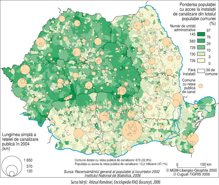
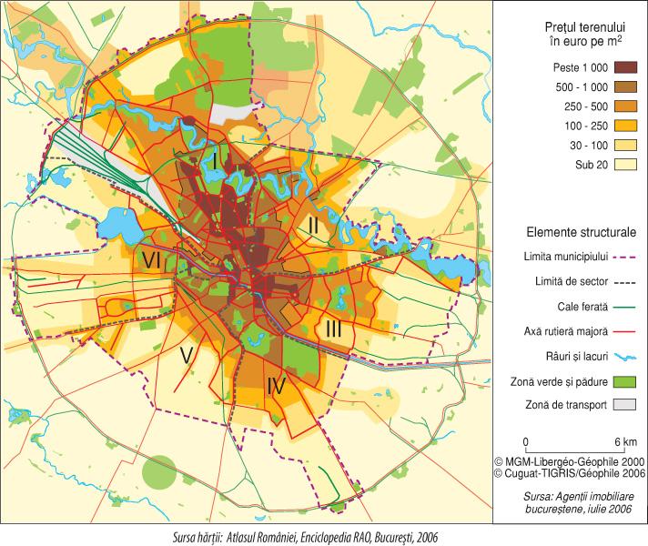
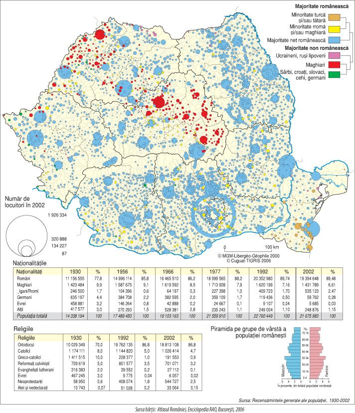
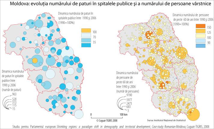
13 Romanian Territorial Atlas Author: CUGUAT-TIGRIS centre (University Al. I. Cuza of Iaşi) Coordinated by MDPWH (Territorial Development department) Pilot-project for use of tools based on ESPON results More than visitors on the site in 6 months
14 Romanian Territorial Atlas Part 1: Hyper Atlas HyperAtlas Europe (based on work of HyperCarte Research Project) HyperAtlas Romania (adaptation for Romania) Part 2: Territorial Atlas Analytic maps (showing current state) Dynamic maps (showing evolutions)
15
16
17
18

19
20
21
22
23
24
25
26
27

28

29
30 Conclusions Romania needs territorial observation system Progress is made but much work awaits ESPON results can be used with success Future steps: Financing and implementing the territorial observation system Ensuring good functioning of the system
31 Thank you!
Launch of the ESPON 2013 Programme. European observation network on territorial development and cohesion
 Launch of the ESPON 2013 Programme European observation network on territorial development and cohesion Framework conditions for the ESPON 2013 Programme Policy development in use of territorial evidence
Implementation of the ESPON 2020 cooperation program. 16 January 2017 Anneloes van Noordt
 Implementation of the ESPON 2020 cooperation program 16 January 2017 Anneloes van Noordt Outline! ESPON Cooperation Program! Specific Objectives! Applied Research! Targeted Analysis! Database & Tools!
Land Use in the context of sustainable, smart and inclusive growth
 Land Use in the context of sustainable, smart and inclusive growth François Salgé Ministry of sustainable development France facilitator EUROGI vice president AFIGéO board member 1 Introduction e-content+
16540/14 EE/cm 1 DG E 1A
 Council of the European Union Brussels, 5 December 2014 (OR. en) 16540/14 ENV 965 CULT 139 NOTE From: To: Subject: General Secretariat of the Council Delegations Charter of Rome on Natural and Cultural
Compact guides GISCO. Geographic information system of the Commission
 Compact guides GISCO Geographic information system of the Commission What is GISCO? GISCO, the Geographic Information System of the COmmission, is a permanent service of Eurostat that fulfils the requirements
The ESPON Programme. Goals Main Results Future
 The ESPON Programme Goals Main Results Future Structure 1. Goals Objectives and expectations Participation, organisation and networking Themes addressed in the applied research undertaken in ESPON projects
Key Indicators for Territorial Cohesion & Spatial Planning Stakeholder Workshop - Project Update. 13 th December 2012 San Sebastián, Basque Country
 Key Indicators for Territorial Cohesion & Spatial Planning Stakeholder Workshop - Project Update 13 th December 2012 San Sebastián, Basque Country Key Aims Explore the use of territorial data in developing
Third Cohesion report February 2004
 February 2004 A new partnership for cohesion Convergence, Competitiveness and Co-operation METREX meeting S. Sebastian, Luisa Sanches DG REGIO The 3rd CR structure 1. Analysis of situation and trends in
The European territory: Strategic developmentd
 The European territory: Strategic developmentd Peter Mehlbye Workshop Strategic Development Catalonia 11 June 2002 THE LECTURE Structure I. Territorial trends II. Strategy for European spatial development
Integrated Territorial Development Strategies in Greece under economic crisis
 Integrated Territorial Development Strategies in Greece under economic crisis INTERSTRAT Interactive Workshop, Warsaw, 12.10.2011 Stella Kyvelou, Assistant Professor, Panteion University, Director of Greek
Stepping into the sea - New evidence on territorial development and the opportunities and risks for European seas and maritime regions
 ESPON 2013 Programme Workshop Stepping into the sea - New evidence on territorial development and the opportunities and risks for European seas and maritime regions 15 May 2013 9h00 16h30 Venue The Norwegian
International Guidelines on Access to Basic Services for All
 International Guidelines on Access to Basic Services for All Presentation and initials lessons from implementation Accessibility to services in regions and cities : measures and policies, OECD 18 June
PART A Project summary
 PART A Project summary A.1 Project identification Project title Project acronym Name of the lead partner organisation in English Specific objective Demonstrattion AF DAF Partner 1.1. Improving innovation
PURR: POTENTIAL OF RURAL REGIONS UK ESPON WORKSHOP Newcastle 23 rd November Neil Adams
 PURR: POTENTIAL OF RURAL REGIONS UK ESPON WORKSHOP Newcastle 23 rd November 2012 Neil Adams PURR: Potential of Rural Regions Introduction Context for the project A spectrum of knowledge Rural Potentials
Key Indicators for Territorial Cohesion and Spatial Planning in Preparing Territorial Development Strategies
 ESPON Evidence in a North European Context Challenges and Opportunities for Territorial Development and Cohesion in a North European Macro Region, 10-11 April, 2014, Vilnius, Lithuania Key Indicators for
South Europe at the crossroads
 Inspire policy making by territorial evidence ESPON Seminar South Europe at the crossroads Are we making the right decisions about accessibility investments for the future? The access to services of general
Urban and rural poles in positive interrelations
 Urban and rural poles in positive interrelations A stake for a better cohesion of the European continent Gérard Peltre president of the international association Rurality-Environment-Development (R.E.D.)
Mediterranean Sea and Territorial Development, Opportunities and Risks
 EESC Hearing Towards an EU Macro-Regional Strategy for the Mediterranean Mediterranean Sea and Territorial Development, Opportunities and Risks Michaela Gensheimer Structure of Intervention Part I: What
No 4 February ESPON: A New and Practical European Research Agenda for Territorial Planning and Development. Cliff Hague Brendan Bartley
 No 4 February 2010 ESPON: A New and Practical European Research Agenda for Territorial Planning and Development Cliff Hague Brendan Bartley ICLRD Briefing Paper Series ESPON: A New and Practical European
Smart City Governance for effective urban governance. David Ludlow Assoc. Professor European Smart Cities University of the West of England, Bristol
 Smart City Governance for effective urban governance David Ludlow Assoc. Professor European Smart Cities University of the West of England, Bristol Complexities of urban territorial governance Complexities
Oman NSDI Business Values and Future Directions. Hassan Alawi Alghazali Acting Director General National Spatial Data Infrastructure
 Oman NSDI Business Values and Future Directions Hassan Alawi Alghazali Acting Director General National Spatial Data Infrastructure Presentation Outline Geospatial Maturity Current Challenges NCSI s Role
Use and demand of regions and cities
 Use and demand of regions and cities > Roger Read > Deputy Director of Physical Planning Strathclyde Regional Council 1976-1996 > Secretary General METREX 1996-present > METREX - founded in 1996 > 50+
ESPON support for Targeted Analyses Ilona Raugze Director
 ESPON support for Targeted Analyses Ilona Raugze Director ESPON EGTC 14 November 2017 ESPON EGTC workshop Targeted Analysis in support of better policy making in cities and regions Inspire policy making
Report. Workshop 5: How can atlases help to organise and promote the seas?
 Workshop 5: How can atlases help to organise and promote the seas? Report 1. Three key messages included on the reporting slide for the last plenary session Atlases help people to visualise intuitively
Cross-border territorial monitoring: Luxembourg
 Cross-border territorial monitoring: Luxembourg Thierry Hengen Policy Advisor on cross-border development and observation Project manager GIS-GR Ministry of Sustainable Development and Infrastructure -
Alps Results from the ESPON Project. Common spatial perspectives for the Alpine area. Towards a common vision
 Results from the ESPON Project Alps 2050 Common spatial perspectives for the Alpine area. Towards a common vision Tobias Chilla, University of Erlangen Cooperation Alps 2020+ 1 & 2 October 2018 Salzburg
New Prospects for Peripheral Rural Regions Helmut Hiess Glasgow, 19th of May 2010
 New Prospects for Peripheral Rural Regions Helmut Hiess Glasgow, 19th of May 2010 ÖROK: Organisation & Tasks Austrian Conference on Spatial Planning (ÖROK, since 1971): Joint organisation by Federal level,
Highlands and Islands European Partnership Response to the Green Paper on Territorial Cohesion
 Highlands and Islands European Partnership Response to the Green Paper on Territorial Cohesion 1 I. Introduction The Highlands & Islands European Partnership (HIEP) is a partnership between the key public
Measuring Regional Development with RIV Models: A Case Study for Romania and the European Union
 European Research Studies, Volume XII, Issue (4), 29 Measuring Regional Development with RIV Models: A Case Study for Romania and the European Union Ph.D. Professor Romeo Ionescu* Abstract: The paper deals
Towards a City Model for Heritage-Led Regeneration and Tourism Development
 Towards a City Model for Heritage-Led Regeneration and Tourism Development Brian Smith, Secretary General European Association of Historic Towns and Regions Summary of Presentation Objective Background
Tackling urban sprawl: towards a compact model of cities? David Ludlow University of the West of England (UWE) 19 June 2014
 19 June 2014") Tackling urban sprawl: towards a compact model of cities? David Ludlow University of the West of England (UWE) 19 June 2014 Impacts on Natural & Protected Areas why sprawl matters? Sprawl creates environmental,
Tackling urban sprawl: towards a compact model of cities? David Ludlow University of the West of England (UWE) 19 June 2014 Impacts on Natural & Protected Areas why sprawl matters? Sprawl creates environmental,
Conurbano s Atlas MALENA HOPP M A L H OO.COM. AR
 Conurbano s Atlas MALENA HOPP M A L ENAHOPP@YA H OO.COM. AR R ESEARCH GRO UP IN LIVING CONDITIONS IN BUENOS A I R ES CONURBANO. UNIVERSI DAD N ACIONAL DE AV E L L A N E DA Conurbano, an heterogeneous region
The National Spatial Strategy
 Purpose of this Consultation Paper This paper seeks the views of a wide range of bodies, interests and members of the public on the issues which the National Spatial Strategy should address. These views
A GIS Tool for Modelling and Visualizing Sustainability Indicators Across Three Regions of Ireland
 International Conference on Whole Life Urban Sustainability and its Assessment M. Horner, C. Hardcastle, A. Price, J. Bebbington (Eds) Glasgow, 2007 A GIS Tool for Modelling and Visualizing Sustainability
Governance and Functional Urban Areas CEMAT Conference
 Governance and Functional Urban Areas CEMAT Conference Mart Grisel Bucharest, Romania 30/05/2017 FUA: various definitions KEY ASPECTS: CITY & COMMUTING AREA The area occupied by a large city and its surrounding
Johannes Suitner Department of Spatial Planning, TU Wien Polycentricity at different scales
 Johannes Suitner Department of Spatial Planning, TU Wien Polycentricity at different scales ESPON Seminar Territory matters: Keeping Europe and its regions competitive 16-17 June 2016 @ Marine Etablissement
MR. George ALEXAKIS, parallel session 3. "Mediterranean Sea Region. laying the conditions. for sustainable growth and jobs"
 parallel session 3 "Mediterranean Sea Region laying the conditions for sustainable growth and jobs" MR. George ALEXAKIS, elected Regional Councillor of Crete, Greece and representative of Crete in CRPM.
ACTION PLAN FOR WORLD HERITAGE IN LATIN AMERICA AND THE CARIBBEAN ( )
") Annex ACTION PLAN FOR WORLD HERITAGE IN LATIN AMERICA AND THE CARIBBEAN (2014-2024) The current Regional Action Plan for Latin America and the Caribbean for 2014-2024 has been elaborated by the State Parties
Annex ACTION PLAN FOR WORLD HERITAGE IN LATIN AMERICA AND THE CARIBBEAN (2014-2024) The current Regional Action Plan for Latin America and the Caribbean for 2014-2024 has been elaborated by the State Parties
ESPON 2020 Cooperation Programme. Anneloes van Noordt MC-member Belgium
 ESPON 2020 Cooperation Programme Anneloes van Noordt MC-member Belgium Anneloes.vannoordt@vlaanderen.be Outline ESPON 2020 Cooperation Programme Applied Research Targeted Analysis Database & Tools Outreach
Poland, European Territory, ESPON Programme Warsaw, 2 July 2007 STRATEGY OF THE ESPON 2013 PROGRAMME
 Poland, European Territory, ESPON Programme 2007-2013 Warsaw, 2 July 2007 STRATEGY OF THE ESPON 2013 PROGRAMME Territory matters Regional diversity as asset Territorial potentials increasing in importance
Possibilities for applying ES assessment results in spatial planning in Latvia
 Possibilities for applying ES assessment results in spatial planning in Latvia Inga Hoņavko LIFE EcosystemServices project manager LIFE Viva Grass seminar, Sigulda, 17.05.2018 Projekts LIFE EcosystemServices,
The Governance of Land Use
 The planning system Levels of government and their responsibilities The Governance of Land Use COUNTRY FACT SHEET NORWAY Norway is a unitary state with three levels of government; the national level, 19
INSPIRE and Land Use Planning System in Portugal
 INSPIRE and Land Use Planning System in Portugal Rui Amaro Alves Director General Directorate General for Territorial Development ruialves@dgterritorio.pt Carlos Simões Senior Technician Directorate General
THE ROLE OF GEOSPATIAL AT THE WORLD BANK
 THE ROLE OF GEOSPATIAL AT THE WORLD BANK INSPIRE Conference Barcelona, Spain September 26, 2016 Kathrine Kelm Senior Land Administration Specialist Global Land and Geospatial Unit The World Bank Group
Work Packages. RECROS Project development workshop. Prague, 30 th April 2015
 Work Packages Prague, 30 th April 2015 Main principles - remarks Protected areas, regions, cities, not only comparison cities/rural areas HU most of cities have their climate strategies good contacts to
Second High Level Forum on GGIM Seminar on Regional Cooperation in Geospatial Information Management Doha, Qatar, 7 February 2013
 Second High Level Forum on GGIM Seminar on Regional Cooperation in Geospatial Information Management Doha, Qatar, 7 February 2013 Overview on Geospatial Activities in Egypt BY : Eng.Nahla Seddik Mohamed
EuroGEOSS for Drought - Linking the European Drought Observatory to global and local scales
 EuroGEOSS for Drought - Linking the European Drought Observatory to global and local scales Barbara Hofer, Stefan Niemeyer, EC-JRC INSPIRE Conference 2010 Cracow June 24, 2010 Drought Relevance Droughts
Low Density Areas : Places of Opportunity. Enrique Garcilazo, OECD Directorate for Public Governance and Territorial Development
 Low Density Areas : Places of Opportunity Enrique Garcilazo, OECD Directorate for Public Governance and Territorial Development Open Days, Brussels, 11 th October, 2016 Outline 1. Performance low density
Status of implementation of the INSPIRE Directive 2016 Country Fiches. COUNTRY FICHE Czech Republic
 Status of implementation of the INSPIRE Directive 2016 Country Fiches COUNTRY FICHE Czech Republic Introduction... 1 1. State of Play... 2 1.1 Coordination... 2 1.2 Functioning and coordination of the
SPLAN-Natura Towards an integrated spatial planning approach for Natura th January, 2017 Brussels. Commissioned by DG Environment
 SPLAN-Natura 2000 Towards an integrated spatial planning approach for Natura 2000 Commissioned by DG Environment 17 th January, 2017 Brussels V. Simeonova (Ph.D.) Drivers towards integrating Biodiversity
Heritage Counts! Economic Impacts of Cultural Heritage European Perspective - Presented by: Dr. Cornelia Dümcke, CULTURE CONCEPTS, Berlin, Germany
 Heritage Counts! Economic Impacts of Cultural Heritage European Perspective - Presented by: Dr. Cornelia Dümcke, CULTURE CONCEPTS, Berlin, Germany The most significant shift in the heritage discourse concerns
5 Use and debate ESPON results
 Policy relevant key findings: Different regions have different possibilities to deliver smart, sustainable and inclusive growth and the economic recovery that Europe is looking for. ESPON findings can
COUNCIL OF EUROPE S SPATIAL DEVELOPMENT POLICY
 ESPON 2103 Programme Open Seminar Territorial Challenges and Cooperation in a Wider Europe Portorož, 2-3 June 2008 COUNCIL OF EUROPE S SPATIAL DEVELOPMENT POLICY Maria José Festas Senior Advisor, Directorate
Harmonizing spatial databases and services at local and regional level
 Harmonizing spatial databases and services at local and regional level A. Ionita 1, M. Caian 2, V. Vassilev 3, V. Craciunescu 2, I. Nedelcu 4 1 Research Institute for Artificial Intelligence, Bucuresti,
Visualization tools for coastal climate change vulnerability assessment and adaptation guidelines: a case study in Cartagena, Colombia
 Visualization tools for coastal climate change vulnerability assessment and adaptation guidelines: a case study in Cartagena, Colombia Vivian Ochoa, Paula Cristina Sierra-Correa, Venus Rocha, Francisco
European spatial policy and regionalised approaches
 Findings of the ESPON 2006 Programme COMMIN Final Conference 26-27 April 2007 European spatial policy and regionalised approaches by Dr. Kai BöhmeB ! Territory matters Structure of presentation! Territorial
Developing Quality of Life and Urban- Rural Interactions in BSR
 Developing Quality of Life and Urban- Rural Interactions in BSR Sakari Saarinen Union of the Baltic Cities, Commission on Environment Seminar on Quality of Life in Small Communities, 27 May 2010, Kärdla,
ESPON 2013 Programme/ Newsletter No 27 9 November 2012
 2002-2012 A Decade of Territorial Evidence ESPON 2013 Programme/ Newsletter No 27, Index Map of the Month Attractiveness of Regions to Migrants and Visitors Events New Projects New Reports ESPON in Your
Implementing a Spatial Decision Support System for Puerto Rico: The Political Process
 Implementing a Spatial Decision Support System for Puerto Rico: The Political Process Brugge,, Belgium April 2008 Guy Engelen and Elías R. Gutiérrez, Ph.D. VITO - Flemish Institute for Technological Research
PLANNING (PLAN) Planning (PLAN) 1
 Planning (PLAN) 1") Planning (PLAN) 1 PLANNING (PLAN) PLAN 500. Economics for Public Affairs Description: An introduction to basic economic concepts and their application to public affairs and urban planning. Note: Cross-listed
Planning (PLAN) 1 PLANNING (PLAN) PLAN 500. Economics for Public Affairs Description: An introduction to basic economic concepts and their application to public affairs and urban planning. Note: Cross-listed
The Added Value of Geospatial Data in a Statistical Office. Pedro Diaz Munoz Director Sectoral and Regional Statistics EUROSTAT European Commission
 The Added Value of Geospatial Data in a Statistical Office Pedro Diaz Munoz Director Sectoral and Regional Statistics EUROSTAT European Commission Why integrate Responsibility of all the information we
Indicators and Policies of Sustainable Development in the European Union
 Bulletin UASVM Horticulture, 66(2)/2009 Print ISSN 1843-5254; Electronic ISSN 1843-5394 Indicators and Policies of Sustainable Development in the European Union Mircea Adrian GRIGORAS University of Agricultural
Sustainable Development Goal 11 and the New Urban Agenda: can planning deliver? Vanessa Watson University of Cape Town 2016
 Sustainable Development Goal 11 and the New Urban Agenda: can planning deliver? Vanessa Watson University of Cape Town 2016 .to reinvigorate the global political commitment to the sustainable development
COMPREHENSIVE LAND-USE MANAGEMENT UNDERSTANDING THE INTERRELATIONSHIP BETWEEN SPATIAL PLANNING, LAND MANAGEMENT AND LAND ADMINISTRATION
 COMPREHENSIVE LAND-USE MANAGEMENT UNDERSTANDING THE INTERRELATIONSHIP BETWEEN SPATIAL PLANNING, LAND MANAGEMENT AND LAND ADMINISTRATION Daniel Galland & Stig Enemark Department of Development and Planning
The Atlantic Arc: New Translations for an Old Identity
 Travailler en réseau The Atlantic Arc: New Translations for an Old Identity Tamara Guirao-Espiñeira CAAC: Conference of Atlantic Arc Cities coordinator@atlanticcities.eu @arcatl @citystoryteller March
What has changed? Spatial development of the current Hungarian border areas nowadays and one century ago
 What has changed? Spatial development of the current Hungarian border areas nowadays and one century ago PÉNZES, János, PhD assistant professor Europe a Century after the End of the First World War (1918-2018)
Globalization & Strategic Spatial Planning Kathy Pain ALDAR Professor of Real Estate Development University of Reading
 Globalization & Strategic Spatial Planning Kathy Pain ALDAR Professor of Real Estate Development University of Reading October 2010 Henley Business School 2010 www.henley.reading.ac.uk Topic for consideration
Figure 10. Travel time accessibility for heavy trucks
 Figure 10. Travel time accessibility for heavy trucks Heavy truck travel time from Rotterdam to each European cities respecting the prescribed speed in France on the different networks - Road, motorway
The ESPON Programme and the use of spatial data on the European level
 The ESPON Programme and the use of spatial data on the European level Plan4Business project ISOCARP Brussels Liaison Office 29 November 2013 Marjan van Herwijnen Project Expert - ESPON Coordination Unit
ACRONYMS AREAS COUNTRIES MARINE TERMS
 Natura 2000 ACRONYMS AREAS COUNTRIES MARINE TERMS DEFINITION A European network of protected sites under the European Habitats and Birds Directives, aiming to protect the most valuable and threatened European
Status of implementation of the INSPIRE Directive 2016 Country Fiches. COUNTRY FICHE Ireland
 Status of implementation of the INSPIRE Directive 2016 Country Fiches COUNTRY FICHE Ireland Introduction... 1 1. State of Play... 2 1.1 Coordination... 2 1.2 Functioning and coordination of the infrastructure...
Spatial Planning & Climate Change
 Spatial Planning & Climate Change A GRIP Approach Joseph Scott, Glasgow & Clyde Valley Strategic Development Plan Authority, Scotland Today s presentation Context Spatial Planning & Climate Change Exploring
Spatial Planning in Metropolitan Areas: SPIMA Project
 Spatial Planning in Metropolitan Areas: SPIMA Project Alfredo Corbalan Brussels-Capital Region Perspective.brussels Brussels Planning Agency ESPON TNO Workshop on spatial planning Brussels October 24th
European Regional and Urban Statistics
 European Regional and Urban Statistics Dr. Berthold Feldmann berthold.feldmann@ec.europa.eu Eurostat Structure of the talk Regional statistics in the EU The tasks of Eurostat Regional statistics Urban
Workshop B Spatial positioning and definition of characteristics
 This presentation expresses the author's views. It does not necessarily reflect the opinion of the ESPON Monitoring Committee, which is not liable for any use that may be made of the information provided.
Proposal for a DIRECTIVE OF THE EUROPEAN PARLIAMENT AND OF THE COUNCIL. establishing an infrastructure for spatial information in the Community
 Proposal for a DIRECTIVE OF THE EUROPEAN PARLIAMENT AND OF THE COUNCIL establishing an infrastructure for spatial information in the Community INSPIRE http://inspire.jrc.it/ Alessandro Annoni 1 EU Commission
Jordan's Strategic Research Agenda in cultural heritage
 Jordan's Strategic Research Agenda in cultural heritage Analysis of main results Alessandra Gandini Amman, Jordan 3 rd November 2013 Main objectives The work performed had the main objective of giving
IAEG SDGs WG GI, , Mexico City
 IAEG SDGs WG GI, 12-14.12.2016, Mexico City UN-GGIM:Europe s perspective and activities to support better integration of geospatial information and statistics and the UN SDG monitoring Pier-Giorgio Zaccheddu,
MiniStRy of national DevelopMent, MiniStRy for national economy. Regional Status Report of Hungary
 MiniStRy of national DevelopMent, MiniStRy for national economy Regional Status Report of Hungary 2010 Ministry of National Development, Ministry for National Economy Regional Status Report of Hungary
COUNCIL OF THE EUROPEAN UNION. Brussels, 2 May /14 CULT 68
 COUNCIL OF THE EUROPEAN UNION Brussels, 2 May 2014 9129/14 CULT 68 NOTE from: General Secretariat of the Council to: Permanent Representatives Committee (Part 1) / Council No. prev. doc.: 8892/14 CULT
Public Disclosure Copy
 Public Disclosure Authorized EAST ASIA AND PACIFIC Vanuatu Social, Urban, Rural and Resilience Global Practice Global Practice Recipient Executed Activities Technical Assistance Loan FY 2013 Seq No: 7
Strengthening the cooperation in the region: Carpathian, Tisa,, Danube and Black Sea areas
 Strengthening the cooperation in the region: Carpathian, Tisa,, Danube and Black Sea areas 14th October 2009 SEE Annual Conference Advancing development through transnational cooperation in South East
Why care about metropolitan and regional perspectives?
 Metropolitan challenges and solutions Why care about metropolitan and regional perspectives? Irma Karjalainen, Director, Helsinki Region Environmental Services Authority HSY, LUMAT Conference, 25 September
National Spatial Arrangement Conception for the period the conditions, process of the development and consultation of the document
 MINISTRY OF REGIONAL DEVELOPMENT National Spatial Arrangement Conception for the period 2008-2033 - the conditions, process of the development and consultation of the document Magdalena Zagrzejewska-Fiedorowicz
The Department of Urban Planning and Design offers a postgraduate course leading to the degree of Master of Science in Urban Planning.
 (THESE SYLLABUSES ARE APPLICABLE TO MASTER OF SCIENCE IN URBAN PLANNING CANDIDATES ADMITTED TO THE CURRICULUM IN THE ACADEMIC YEAR 2016-2017 AND THEREAFTER) SYLLABUSES FOR THE DEGREE OF MASTER OF SCIENCE
PAN AMERICAN INSTITUTE OF GEOGRAPHY AND HISTORY Specialized Organization of the OAS
 PAN AMERICAN INSTITUTE OF GEOGRAPHY AND HISTORY Specialized Organization of the OAS 10 th UNRCC Americas United Nations, New York, 20 August 2013 PAIGH, SIRGAS, PC-IDEA and GeoSUR 2013-2015 Joint Action
Conference on Urban Development Strategies in the Mediterranean Barcelona, March 14-15, 2011
 Analysing Urban Development Strategies: the OECD Approach by Adam Knelman Ostry Counsellor, Regional Development Policy adam.ostry@oecd.org Conference on Urban Development Strategies in the Mediterranean
Swedish Spatial Data Infrastructure and the National Geodata Strategy
 Submitted to United Nations Committee of Experts on Global Geospatial Information Management Seventh Session New York, August 2017 Country Report of Sweden Swedish Spatial Data Infrastructure and the National
Marine Spatial Planning in Hellas; Recent Facts and Perspectives
 XXV FIG CONGRESS Engaging the Challenges, Enhancing the Relevance Kuala Lumpur, Malaysia 16 21 June 2014 Marine Spatial Planning in Hellas; Recent Facts and Perspectives Mrs. Chaiditsa BOLANOU Surveying
INTRODUCING THE EUROPEAN DIMENSION
 INTRODUCING THE EUROPEAN DIMENSION OF DANISH PLANNING ESPON/ENECON POSTGRADUATE WORKSHOP TERRITORIAL GOVERNANCE AND COOPERATION UNIVERSITY OF EASTERN FINLAND JOENSUU, FINLAND OCTOBER 19, 2012 DANIEL GALLAND
COMMON CONCEPTUAL AND OPERATIONAL FRAMEWORKS FOR RESEARCH AND SUSTAINABLE MANAGEMENT OF NESTED SOCIO-ECOLOGICAL SYSTEMS ACROSS LARGE WATERSHEDS
 COMMON CONCEPTUAL AND OPERATIONAL FRAMEWORKS FOR RESEARCH AND SUSTAINABLE MANAGEMENT OF NESTED SOCIO-ECOLOGICAL SYSTEMS ACROSS LARGE WATERSHEDS Angheluta VADINEANU 1 & Nusret KARAKAYA 2 1 Department of
MICRO-SCALE GEOSTATISTICAL ANALYSIS OF THE LEVEL OF DEVELOPMENT. CASE STUDY: MOUNTAINOUS AND SUB- CARPATHIAN AREA OF IALOMIŢA HYDROGRAPHIC BASIN
 Geographia Technica, Special Issue, 2010, pp. 47 to 51 MICRO-SCALE GEOSTATISTICAL ANALYSIS OF THE LEVEL OF DEVELOPMENT. CASE STUDY: MOUNTAINOUS AND SUB- CARPATHIAN AREA OF IALOMIŢA HYDROGRAPHIC BASIN Ioan
The future of spatial planning related impact assessment in Estonia. Tiit Oidjärv Estonian Ministry of the Interior, spatial planning department
 The future of spatial planning related impact assessment in Estonia Tiit Oidjärv Estonian Ministry of the Interior, spatial planning department 22.04.2015 IAIA2015 Image: Google Earth Republic of Estonia
Modelling and measuring the impact of heritage: a multi-level holistic approach
 Modelling and measuring the impact of heritage: a multi-level holistic approach Jim McLoughlin, Jaime Kaminski and Babak Sodagar CUBIST Research, Brighton Business School, University of Brighton Brian
Use of climate reanalysis for EEA climate change assessment. Blaz Kurnik. European Environment Agency (EEA)
") Use of climate reanalysis for EEA climate change assessment Blaz Kurnik European Environment Agency (EEA) 2016: EEA content priorities Circular economy Climate and Energy Sustainable Development Goals
Use of climate reanalysis for EEA climate change assessment Blaz Kurnik European Environment Agency (EEA) 2016: EEA content priorities Circular economy Climate and Energy Sustainable Development Goals
INTEGRATION OF GIS AND MULTICRITORIAL HIERARCHICAL ANALYSIS FOR AID IN URBAN PLANNING: CASE STUDY OF KHEMISSET PROVINCE, MOROCCO
 Geography Papers 2017, 63 DOI: http://dx.doi.org/10.6018/geografia/2017/280211 ISSN: 1989-4627 INTEGRATION OF GIS AND MULTICRITORIAL HIERARCHICAL ANALYSIS FOR AID IN URBAN PLANNING: CASE STUDY OF KHEMISSET
The Process of Spatial Data Harmonization in Italy. Geom. Paola Ronzino
 The Process of Spatial Data Harmonization in Italy Geom. Paola Ronzino ISSUES Geospatial Information in Europe: lack of data harmonization the lack of data duplication of data CHALLENGES Challenge of INSPIRE:
a national geological survey perspective François ROBIDA BRGM (French Geological Survey)
") a national geological survey perspective François ROBIDA BRGM (French Geological Survey) Pre-Conference Seminar on Socio-Economic Value of Geospatial for National and Regional Development 21 August 2017,
a national geological survey perspective François ROBIDA BRGM (French Geological Survey) Pre-Conference Seminar on Socio-Economic Value of Geospatial for National and Regional Development 21 August 2017,
The National Policy Strategy for Infrastructure and Spatial Planning CODE24 CONFERENCE. Emiel Reiding
 The National Policy Strategy for Infrastructure and Spatial Planning Emiel Reiding Structure of presentation 1. Spatial planning in the Netherlands 2. National Policy Strategy Aims National interests 3.
EA SEA-WAY Project. 7 th Coordination Meeting. WP5 Development of sustainable passenger transport models for the Adriatic basin and capacity building
 EA SEA-WAY Project 7 th Coordination Meeting WP5 Development of sustainable passenger transport models for the Adriatic basin and capacity building 3 rd Cross Border Board Ravenna, January 26, 2016 The