Sediment Dynamics in Restored Tidal Wetlands of San Francisco Bay
|
|
|
- Judith Robyn Carson
- 5 years ago
- Views:
Transcription

 Evyan Borgnis &")

1 Sediment Dynamics in Restored Tidal Wetlands of San Francisco Bay John Callaway & Jennifer Gagnon (USF) Lisa Schile (UC Berkeley) Evyan Borgnis & Tom Parker (SFSU) Donna Ball (HT Harvey & Assoc.) Gene Turner & Charlie Milan (LSU)


2 Past and Present Distribution of SF Bay Wetlands (from San Francisco Estuary Institute)

3 Huge interest in restoration in SF Bay, but many potential restoration sites (including former salt ponds) have subsided substantially and need to increase elevation to reach threshold elevations for vegetation establishment David Sanger
4 Theoretical Tidal Wetland Development (from Williams and Orr 2002)
5 Accretion Rate Theoretical Tidal Wetland Development MLLW MTL MHHW Elevation
6 Muzzi Marsh Crissy Field Island Ponds / A21 Pond A6


7 South Bay Salt Pond Restoration Project Island Ponds / A21 Breached in March 2006 Pond A6 Breached in December 2010
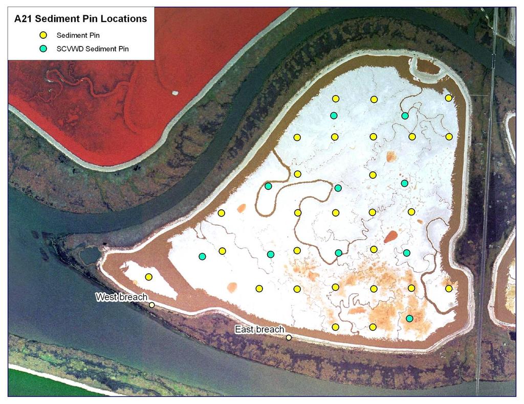
8 100 m

9

10
11 Cumulative change in pin height (mm) Island Pond Sediment Accretion Southern stations Time post-breach (months)
12 Cumulative change in pin height (mm) Island Pond Sediment Accretion Northern stations Southern stations Time post-breach (months)
13 Cumulative change in pin height (mm) Island Pond Sediment Accretion Northern stations Southern stations Time post-breach (months)
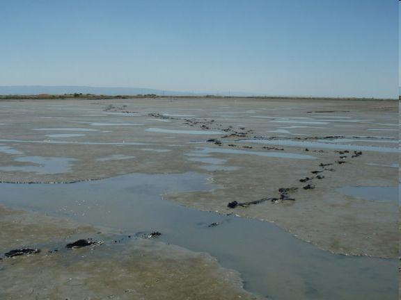


14 6 months pre-restoration 36 months 24 months

15 Photos Cris Benton

16 Pond A6: Breached December m
17 Cumulative change in pin height (mm) Pond A6 Sediment Accretion Time post-breach (months)
18 Cumulative change in pin height (mm) Ponds A6 & A21 Sediment Accretion Pond A21: Southern stations Pond A Time post-breach (months)
19 Muzzi Marsh Crissy Field Island Ponds / A21 Pond A6

20 Muzzi Marsh: Restored m


21 SETs & Markers Sedimentation Erosion Table (SET) marsh surface feldspar marker horizon
22 Cumulative Sediment Accretion (mm) Muzzi Marsh Sediment Accretion Low Marsh Mid Marsh High Marsh Cumulative change in pin height (mm)

23 Crissy Field Marsh Restoration Project (from Robert Campbell Photography)

24 Crissy Field Marsh: Restored m Transect #3 Transect #2 Transect #1
25 Crissy Field Marsh Sediment Accretion HIGH STATIONS Cumulative change in elevation (mm) MID STATIONS Transect 1 Transect 2 Transect 3 LOW STATIONS

26

")


27 (from Kristen Ward, NPS)

28 Petaluma River Marsh Coon Island Rush Ranch China Camp Muzzi Marsh Browns Island Crissy Field Whale s Tail Marsh Island Ponds Greco Island Pond A6


29 137 Cs Activity (dpm/g) Pb Activity (dpm/g) Depth (cm)

30 Low station 100 m Mid station High station
31 Accretion Rate (cm/yr) Browns Island Rush Ranch Coon Island Petaluma River Marsh China Camp Whales Tail Low Mid High 137 Cs 210 Pb Natural Wetland Accretion Rates 37 dated cores using both 137 Cs and 210 Pb (out of 48 cores collected)! Very consistent rates of accretion in mid and high marsh: ~0.3 cm/yr Low marsh: four sites ~0.6 cm/yr using 137 Cs Elevation (Callaway et al., in press)
32 Mean Suspended Sediment Concentration (mg/l) Marsh Suspended Sediment Concentrations (J. Gagnon, USF)
33 Summary of Accretion Rates across Sites Sites Pond A6 Island Ponds Muzzi Marsh Crissy Field Low marsh (natural) Mid and high marsh (natural) Range of accretion rates > 200 mm/yr 10 to 100 mm/yr 3 to 10 mm/yr -5 to 4 mm/yr Up to 6 mm/yr 3 mm/yr
34 Accretion Rate Theoretical Tidal Wetland Development MLLW MTL MHHW Elevation
35 Accretion Rate Theoretical Tidal Wetland Development A6 200 mm/yr Island Ponds 100 mm/yr Lower Muzzi Marsh 10 mm/yr Natural low marsh 6 mm/yr Natural mid & high marsh 3 mm/yr Elevation
36 Conclusions Rapid sediment accumulation at low elevations in most restored marshes Results closely match expectations of marsh development over time Natural wetlands are keeping pace with current rates of SLR High suspended sediment concentrations within SF Bay marshes

37 Acknowledgments Gordon and Betty Moore Foundation South Bay Salt Pond Project & the Resources Legacy Fund San Francisco Bay Conservation and Development Commission & US EPA Coastal Conservancy Association USF Faculty Development Fund Many USF and SFSU students
Tidal Wetlands & Climate Change
 Tidal Wetlands & Climate Change Tom Parker (SF State) John Callaway (Univ SF) Lisa Schile (UCB); Ellen Herbert (Indiana U); Evyan Borgnis (USF, SFSU) Jessica Vandenberg (SFSU) Vance Vredenburg (SF State)
Wetland Sediment Dynamics at Crissy Field Marsh Annual Report
 Wetland Sediment Dynamics at Crissy Field Marsh 27 Annual Report John Callaway Department of Environmental Science University of San Francisco 217 Fulton St. San Francisco, CA 94117 (415) 422-572 callaway@usfca.edu
DYNAMICS OF SEDIMENT ACCUMULATION IN POND A21 AT THE ISLAND PONDS
 DYNAMICS OF SEDIMENT ACCUMULATION IN POND A21 AT THE ISLAND PONDS John C. Callaway 1 V. Thomas Parker 2 Lisa M. Schile 3 Ellen R. Herbert 2 Evyan L. Borgnis 1 Submitted to: Ann Buell California State Coastal
Elkhorn Slough Marsh Stratigraphy
 Elkhorn Slough Marsh Stratigraphy Prehistoric marsh extent & recent sediment accretion Elizabeth Burke Watson, Ph.D. U.S. Environmental Protection Agency Narragansett, RI Paleoecology: Reconstruction of
Using Remote Sensing to Map the Evolution of Marsh Vegetation in the South Bay of San Francisco
 Using Remote Sensing to Map the Evolution of Marsh Vegetation in the South Bay of San Francisco Brian Fulfrost Design, Community and Environment (DC&E) 6 th Annual Bay-Delta Science Conference PROJECT
The rate and fate of coastal carbon burial
 The rate and fate of coastal carbon burial Matthew L. Kirwan, Virginia Institute of Marine Science Main Points Marsh size Marsh accretion 1. SLR drives wetland carbon burial in vertical and lateral dimensions
Limits and Potentials of High Resolution Terrestrial Laser Scanning in Monitoring Estuarine Geomorphologic Variability.
 Limits and Potentials of High Resolution Terrestrial Laser Scanning in Monitoring Estuarine Geomorphologic Variability Charlie Endris January 20, 2010 Elkhorn Slough: Erosion and Habitat Loss Evolution
Carbon Sequestration Potential from Coastal Wetlands Restoration Sites
 Carbon Sequestration Potential from Coastal Wetlands Restoration Sites Insert then choose Picture select your picture. Right click your picture and Send to back. Paul Krause, Alyssa Beach Emily Cooper,
Should (R)SET-MH data be used to forecast the effects of sea level rise on wetland resilience and carbon sequestration?
SET-MH data be used to forecast the effects of sea level rise on wetland resilience and carbon sequestration?") Should (R)SET-MH data be used to forecast the effects of sea level rise on wetland resilience and carbon sequestration? Randall W. Parkinson, Ph.D., P.G. Institute for Water and Environment Florida International
Should (R)SET-MH data be used to forecast the effects of sea level rise on wetland resilience and carbon sequestration? Randall W. Parkinson, Ph.D., P.G. Institute for Water and Environment Florida International
Pablo Bay in Sonoma, Solano, and Napa Counties. It is owned and managed by the U.S. Fish and Wildlife
 Appendix L San Pablo Bay Marsh Introduction San Pablo Bay National Wildlife Refuge marsh (hereafter San Pablo) is located on the north shore of San Pablo Bay in Sonoma, Solano, and Napa Counties. It is
IS THERE ENOUGH SEDIMENT? Presentation at the State of the Estuary Conference San Francisco, CA, October 9-10, By Philip B.
 IS THERE ENOUGH SEDIMENT? Presentation at the State of the Estuary Conference San Francisco, CA, October 9-10, 2001 By Philip B. Williams 1. INTRO I AM TEMPTED TO MAKE THIS THE SHORTEST TALK OF THE CONFERENCE:
Design of Levee Breaches in Sheltered Water for Flood Risk Reduction & Marsh Restoration ASFMP; June 5, 2014 Presented By:
 Design of Levee Breaches in Sheltered Water for Flood Risk Reduction & Marsh Restoration ASFMP; June 5, 2014 Presented By: Rohin Saleh Alameda County Flood Control District Matt Powers, P.E. GEI Consultants
Morro Bay National Estuary Program. Sediment Monitoring Report 2016
 Morro Bay National Estuary Program Sediment Monitoring Report 2016 Prepared by Morro Bay National Estuary Program 601 Embarcadero, Suite 11 Morro Bay, CA 93442 October 2017 TABLE OF CONTENTS Executive
Critical Coastal Habitat Assessment. Long-term monitoring in Tampa Bay
 Critical Coastal Habitat Assessment Long-term monitoring in Tampa Bay Kara Radabaugh, Ryan Moyer, Ed Sherwood, Gary Raulerson, Amanda Chappel, Taylor Nielsen, Reba Campbell, and Emma Dontis. Critical Coastal
Regional Sediment Management Science Workshop: Sediment in San Francisco Bay
 Regional Sediment Management Science Workshop: Sediment in San Francisco Bay Purpose Co-sponsored by BCDC and USGS April 19-20, 2010 at USGS, Menlo Park, CA Discuss recent scientific results related to
Assessing marsh response from sea-level rise applying local site conditions: Humboldt Bay wetlands
 Assessing marsh response from sea-level rise applying local site conditions: Humboldt Bay wetlands U. S. Geological Survey, Western Ecological Research Center Addendum - Data Summary Report February 23,
Baseline Estuarine-Upland Transition Zone
 Baseline Estuarine-Upland Transition Zone in SF, San Pablo and Suisun Bays 10/5/18 Prepared for San Francisco Bay Joint Venture (SFBJV) Prepared by Brian Fulfrost, Principal bfaconsult@gmail.com with additional
Some Thoughts on the Role of Elevation
 Some Thoughts on the Role of Elevation Data in Sea-level Rise Impact Assessments Rob Thieler* U.S. Geological Survey Coastal and Marine Geology Program Woods Hole, MA *i l d t i l d f D C h D G h *includes
Statement of Impact and Objectives. Watershed Impacts. Watershed. Floodplain. Tumblin Creek Floodplain:
 Tumblin Creek Floodplain: Impacts Assessment and Conceptual Restoration Plan Casey A. Schmidt Statement of Impact and Objectives Urbanization has increased stormflow rate and volume and increased sediment,
9 th INTECOL Orlando, Florida June 7, 2012
 Restoration of the Everglades Saline Wetlands and Florida Bay: Responses Driven from Land and Sea David Rudnick 1, Colin Saunders 2, Carlos Coronado 2, Fred Sklar 2 Erik Stabenau 1, Vic Engel 1, Rene Price
Planning for the Future of Humboldt Bay: Sea Level Rise, Sediment Management, Sand Spits and Salt Marshes. Joel Gerwein
 Planning for the Future of Humboldt Bay: Sea Level Rise, Sediment Management, Sand Spits and Salt Marshes Joel Gerwein Introduction to Humboldt Bay Setting Economy, community, and environment Sediment
Assessing the Permanence of Blue Carbon Sinks
 Assessing the Permanence of Blue Carbon Sinks with Rising Sea Levels Gail L. Chmura and Dante D. Torio Department of Geography, McGill University and Global Environmental and Climate Change Centre Montreal,
Taunton River Salt Marsh Assessment Results from 2014 season
 Taunton River Salt Marsh Assessment Results from 2014 season December, 2014 During the late summer and fall of 2014, Save The Bay evaluated salt marshes in Assonet Bay, Freetown and Broad Cove in Dighton
Sediment Management in the Coastal Bays
 Sediment Management in the Coastal Bays Introduction Need for ecosystem view of sediment management in Coastal Bays Island loss and restoration Navigation needs Habitat Trade offs Living Shoreline Requirements
Aquatic Transfer Facility (ATF) San Pablo Bay (SPB) Proposed Region of ATF. Proposed Seabed Pipeline
 San Pablo Bay (SPB) Proposed Region of ATF. Proposed Seabed Pipeline") Aquatic Transfer Facility (ATF) San Pablo Bay (SPB) Proposed Region of ATF Proposed Seabed Pipeline Technical Studies An Overview Scope: Provide background and new scientific information and analysis for
Aquatic Transfer Facility (ATF) San Pablo Bay (SPB) Proposed Region of ATF Proposed Seabed Pipeline Technical Studies An Overview Scope: Provide background and new scientific information and analysis for
Tony Pratt, DNREC to The Center for the Inland Bays Scientific and Technical Advisory Committee. August 21, 2009
 Sea Level Rise in Delaware Presented by Tony Pratt, DNREC to The Center for the Inland Bays Scientific and Technical Advisory Committee August 21, 2009 Sea level has been fluctuating ever since there have
Home About Us Articles Press Releases Image Gallery Contact Us Media Kit Free Subscription 10/5/2006 5:56:35 PM
 Home About Us Articles Press Releases Image Gallery Contact Us Media Kit Free Subscription 10/5/2006 5:56:35 PM Industry Resources Industry Directory NASA Links Missions/Launches Calendar Human development
LINKING DOWNSCALED GLOBAL CLIMATE MODELS TO PLANNING LEVEL ECOSYSTEM MODELS
 LINKING DOWNSCALED GLOBAL CLIMATE MODELS TO PLANNING LEVEL ECOSYSTEM MODELS Eric White 1, Ehab Meselhe 1, Angelina Freeman 2, Mandy Green 2, David Lindquist 2, Alaina Grace 1, Denise Reed 1, and Yushi
Modeling Sea-Level Rise in Coastal Wetlands: Understanding Potential Impacts and Their Implications for Management on Cape Cod
 Modeling Sea-Level Rise in Coastal Wetlands: Understanding Potential Impacts and Their Implications for Management on Cape Cod C a p e C o a s t a l C o n f e r e n c e H y a n n i s R e s o r t a n d
ELKHORN SLOUGH TECHNICAL REPORT SERIES 2012: 2
 ELKHORN SLOUGH TECHNICAL REPORT SERIES 2012: 2 Sponsored by the Elkhorn Slough National Estuarine Research Reserve and the Elkhorn Slough Foundation Water levels, wetland elevations, and marsh loss Eric
The Use of Geographic Information Systems to Assess Change in Salt Marsh Ecosystems Under Rising Sea Level Scenarios.
 The Use of Geographic Information Systems to Assess Change in Salt Marsh Ecosystems Under Rising Sea Level Scenarios Robert Hancock The ecological challenges presented by global climate change are vast,
Primer on Coastal Erosion And Habitat Creation
 2 nd Regional Conference Dredging, Beach Nourishment & Bird Conservation Primer on Coastal Erosion And Habitat Creation Timothy Kana Ph.D Source: Newsday 1962 Photo by Kelsey Aerials 1978 Source: U Mass
Increasing Salt Marsh Resilience in the Face of SLR Investigating Thin Layer Deposition (Sediment Augmentation) as a Management Technique
 as a Management Technique") Increasing Salt Marsh Resilience in the Face of SLR Investigating Thin Layer Deposition (Sediment Augmentation) as a Management Technique Megan Tyrrell Waquoit Bay National Estuarine Research Reserve Coastal
Increasing Salt Marsh Resilience in the Face of SLR Investigating Thin Layer Deposition (Sediment Augmentation) as a Management Technique Megan Tyrrell Waquoit Bay National Estuarine Research Reserve Coastal
South San Francisco Bay Shoreline Studies for EIA 11 with Project Conditions
 South San Francisco Bay Shoreline Studies for EIA 11 with Project Conditions U.S. Army Corps of Engineers San Francisco District Ms. Lisa Andes Mr. Craig Conner Dr. Frank Wu Dr. Jen-Men Lo Dr. Michael
Australian Coastal Councils Conference
 Australian Coastal Councils Conference 11 March 2015 Estimating Future Coastal Inundation and Erosion Hazards Dr Andrew McCowan Dr Christine Lauchlan-Arrowsmith Warwick Bishop Background Victorian Future
Estuarine marshes along the Elbe: past, present and future
 Universität Hamburg Deltas and Climate Change - : past, present and future Kai Jensen & S. Albrecht, Chr. Butzeck, G. Engels, F. Müller, U. Schröder Universität Hamburg kai.jensen@botanik.uni-hamburg.de
Whiskey Island Marsh Creation Rolling with the Punches
 Whiskey Island Marsh Creation Rolling with the Punches Santiago Alfageme, M&N Jerry Carroll, LADNR Brad Miller, LADNR Project Location Historic Island Retreat Previous Restoration Project Whiskey Island
Baylands Ecosystem Habitat Goals Science Update 2014
 Baylands Ecosystem Habitat Goals Science Update 2014 Planning for healthy shoreline ecosystems in an urbanized estuary Letitia Grenier Science Coordinator, Baylands Ecosystem Habitat Goals Reconciling
HISTORICAL DELTA LANDSCAPES Conceptual models for building a diverse and resilient future
 HISTORICAL DELTA LANDSCAPES ITEM REMOVED DUE TO COPYRIGHT STATUS Conceptual models for building a diverse and resilient future Robin Grossinger and Alison Whipple San Francisco Estuary Institute/Aquatic
Eco-hydromorphic Characterization of the Louisiana Coastal Region Using Multiple Remotely Sensed Data Sources and Analyses
 National Wetlands Research Center Eco-hydromorphic Characterization of the Louisiana Coastal Region Using Multiple Remotely Sensed Data Sources and Analyses 1Holly Beck, 2 Brady Couvillion, 1 Nadine Trahan
USGS efforts to model sea-level rise impact to tidal marshes along the California coast.
 USGS efforts to model sea-level rise impact to tidal marshes along the California coast. Karen Thorne 1 J.Y Takekawa 1, K. Buffington 1, K. Swanson 2, J. Drexler 2, D.Schoellhamer 2, M. Casazza 3, and
Tidal Wetland Vegetation
 Wetlands Regional Monitoring Program Plan 00 Data Collection Protocol Michael Vasey San Francisco State University San Francisco CA John Callaway University of San Francisco San Francisco CA V. Thomas
Shoreline Evolution: Lancaster County, Virginia Rappahannock River and Chesapeake Bay Shorelines
 Shoreline Evolution: Lancaster County, Virginia Rappahannock River and Chesapeake Bay Shorelines Virginia Institute of Marine Science College of William & Mary Gloucester Point, Virginia March 2012 Shoreline
Sea Level Affecting Marshes Model (SLAMM) for Coastal Long Island Sound:
 for Coastal Long Island Sound:") 2100 DATA VIEWER MANUAL Sea Level Affecting Marshes Model (SLAMM) for Coastal Long Island Sound: Using a Web Mapping Application Data Viewer to Examine Predicted Land Cover Change for 2100 AUTHOR: KEVIN
2100 DATA VIEWER MANUAL Sea Level Affecting Marshes Model (SLAMM) for Coastal Long Island Sound: Using a Web Mapping Application Data Viewer to Examine Predicted Land Cover Change for 2100 AUTHOR: KEVIN
SUMMARY. Sediment Properties Grain Sizes and Densities Bulk Density, Cohesion, Strength. Compaction & Dewatering
 Wind Waves and Wetlands Workshop: Assessing the Need for and Approaches to Attenuate Wind-Wave Energy in Tidal Wetland Systems March 18, 2008, San Francisco, CA Sponsors: San Francisco Bay Conservation
Preliminary Data Release for the Humboldt Bay Sea Level Rise Vulnerability Assessment: Humboldt Bay Sea Level Rise Inundation Mapping
 Preliminary Data Release for the Humboldt Bay Sea Level Rise Vulnerability Assessment: Humboldt Bay Sea Level Rise Inundation Mapping Prepared by: Jeff Anderson, Northern Hydrology & Engineering (jeff@northernhydrology.com)
Current and Future Technology Applications for Coastal Zone Management. Bruce K. Carlisle, Acting Director Office of Coastal Zone Management
 Current and Future Technology Applications for Coastal Zone Management Bruce K. Carlisle, Acting Director Office of Coastal Zone Management The Massachusetts Coastal Zone Management Program Approved in
A process-based approach toward assessing the coastal impact of projected sea level rise and severe storms
 A process-based approach toward assessing the coastal impact of projected sea level rise and severe storms Patrick Barnard 1, Cheryl Hapke 2, Li Erikson 1, Amy Foxgrover 1, and Maarten van Ormondt 3 1
Port Susan Bay Estuary Restoration Project Post Construction Monitoring
 Port Susan Bay Estuary Restoration Project Post Construction Monitoring The Nature Conservancy ESRP Project: Port Susan Bay Estuary Restoration ESRP, RCO #11-1650R, Amendment #2 The Port Susan Bay Dike
Third Annual Monitoring Report Tidal Wetland Restoration 159 Long Neck Point Road, Darien, CT NAE
 1) Project Overview Third Annual Monitoring Report Tidal Wetland Restoration 159 Long Neck Point Road, Darien, CT NAE-2007-1130 December 15, 2014 This is the third year of a five year monitoring program
Disturbance, site, and vegetation feedbacks create landscape structure in South Florida coastal wetlands. M Ross, K Zhang, B Thapa, and D Gann
 Disturbance, site, and vegetation feedbacks create landscape structure in South Florida coastal wetlands M Ross, K Zhang, B Thapa, and D Gann Department of Earth & Environment Florida International University
APPENDIX F SEDIMENT DEPOSITION AND HABITAT CONVERSION ANALYSIS
 APPENDIX F SEDIMENT DEPOSITION AND HABITAT CONVERSION ANALYSIS San Dieguito Lagoon W-19 Restoration Project Draft EIR March 2017 Appendices Introduction: The following is an analysis to provide the volume
San Francisco Bay Living Shorelines Project Physical Properties Report, November Environmental Science Associates (ESA)
") San Francisco Bay Living Shorelines Project Physical Properties Report, November 2014 Environmental Science Associates (ESA) Table of Contents 1 Introduction... 1 2 Methods... 3 2.1 Water Column Measurements...
San Francisco Bay Living Shorelines Project Physical Properties Report, November 2014 Environmental Science Associates (ESA) Table of Contents 1 Introduction... 1 2 Methods... 3 2.1 Water Column Measurements...
Freshwater-Tidal Gradients: Eco-geomorphology Linkages to Watershed-Estuarine Dynamics
 Freshwater-Tidal Gradients: Eco-geomorphology Linkages to Watershed-Estuarine Dynamics Kathy Boomer (The Nature Conservancy) Scott Ensign (Stroud Research) Greg Noe (USGS) Concluding Speculations: It s
Characterizing Tidal Inundation of Wetlands in the Murderkill Estuary (Kent County, DE)
") Characterizing Tidal Inundation of Wetlands in the Murderkill Estuary (Kent County, DE) Tom McKenna Delaware Geological Survey University of Delaware Thermal Imaging Can temperature be used as an indicator
Characterizing Tidal Inundation of Wetlands in the Murderkill Estuary (Kent County, DE) Tom McKenna Delaware Geological Survey University of Delaware Thermal Imaging Can temperature be used as an indicator
Sea Level Rise and the Scarborough Marsh Scarborough Land Trust Annual Meeting April 24, 2018
 Sea Level Rise and the Scarborough Marsh Scarborough Land Trust Annual Meeting April 24, 2018 Peter A. Slovinsky, Marine Geologist Maine Geological Survey Funded by: 50% 40% Figure modified from Griggs,
Section 145 Climate Change and Sea Level Rise
 Section 145 Climate Change and Sea Level Rise A. Definitions Rhode Island Coastal Resources Management Program 1. Climate is the long-term weather average observed within a geographic region, and climate
Appendix B. SLAMM Analysis of Kenai Peninsula and Anchorage, AK. Final Report
 Appendix B SLAMM Analysis of Kenai Peninsula and Anchorage, AK Final Report For: Jim Adams Director, Pacific Region National Wildlife Federation Anchorage, AK And: David Wigglesworth Coastal Program Manager
Solutions to Flooding on Pescadero Creek Road
 Hydrology Hydraulics Geomorphology Design Field Services Photo courtesy Half Moon Bay Review Solutions to Flooding on Pescadero Creek Road Prepared for: San Mateo County Resource Conservation District
Oyster Reef for Shoreline Stabilization and Restoration. Jason Kirkpatrick Conservation Program Manager MacDill AFB Tampa, Florida
 Oyster Reef for Shoreline Stabilization and Restoration Jason Kirkpatrick Conservation Program Manager MacDill AFB Tampa, Florida Interbay Penninsula Port of Tampa X The few remaining mangroves are being
Mussel Powered Living Shorelines for Salt Marsh Erosion Control
 Mussel Powered Living Shorelines for Salt Marsh Erosion Control Laura Whalen Danielle Kreeger David Bushek Angela Padeletti Josh Moody Partnership for the Delaware Estuary Haskin Shellfish Research Lab
Coastal Tidal Marshes
 Virginia s Wetlands Coastal Tidal Marshes Hydrology driven by lunar tides; Stresses include tidal inundation and/or salts; Found along high latitudes along intertidal coasts; Comprise ~ 70% wetlands of
Planning for Annapolis Sea Level Rise and Future Extreme Water Levels
 Planning for Annapolis Sea Level Rise and Future Extreme Water Levels U.S. Naval Academy Sea Level Rise Advisory Council 31 October 2017 CAPT Emil Petruncio, USN (Ret.), PhD Associate Professor Gina Henderson
Evolution of Tidal Creek Networks in a High Sedimentation Environment: A 5-year Experiment at Tijuana Estuary, California
 Estuaries Vol. 28, No. 6, p. 795 811 December 2005 Evolution of Tidal Creek Networks in a High Sedimentation Environment: A 5-year Experiment at Tijuana Estuary, California KATY J. WALLACE 1,JOHN C. CALLAWAY
netw rks Guided Reading Activity Essential Question: How does geography influence the way people live? Earth's Physical Geography
 Guided Reading Activity Lesson 1 Earth and the Sun Essential Question: How does geography influence the way people live? Looking at Earth Directions: What are the layers that make up Earth? Use your textbook
Sediment Deposition LET THE RIVER RUN T E A C H E R. Activity Overview. Activity at a Glance. Time Required. Level of Complexity.
 Activity at a Glance Grade: 6 9 Subject: Science Category: Physical Science, Earth Science Topic: Deposition, River Systems Time Required Two 45-minute periods Level of Complexity Medium Materials* TI-73
Eco Bay Pathways Watershed related exhibits in the Exploratorium
 Eco Bay Pathways Watershed related exhibits in the Exploratorium This Pathwa y is a guide to engagement wi th museu m exhibit s at the Explo ratorium and includes activiti es for p re- an d post-fi eldtri
Chesapeake Bay Seminar Series
 Chesapeake Bay Seminar Series Sea level rise and coastal change: What the last several hundred years and Hurricane Isabel tell us about future coastal vulnerability in Chesapeake Bay Michael Kearney (Department
Sea-level Rise on Cape Cod: How Vulnerable Are We? Rob Thieler U.S. Geological Survey Woods Hole, MA
 Sea-level Rise on Cape Cod: How Vulnerable Are We? Rob Thieler U.S. Geological Survey Woods Hole, MA Outline Sea-level and coastal processes Past sea-level change Predictions for the future Coastal responses
Stop 1: Marmot Dam Stop 1: Marmot Dam
 Stop 1: Marmot Dam Stop 1: Marmot Dam Following the removal of Marmot Dam in 2007, the fate of the reservoir sediments has been monitored through a series of surveys and sediment transport measurements.
DISCUSSION PURPOSES ONLY C A L I F O R N I A S T A T E L A N D S C O M M I S S I O N
 C A L I F O R N I A S T A T E L A N D S C O M M I S S I O N SAN JOAQUIN RIVER REACH 2B OVERVIEW OF THE CALIFORNIA STATE LANDS COMMISSION ADMINISTRATIVE MAPS PRESENTATION Water Boundary Principles Best
Integrated Ecological Modeling and Decision Analysis within the Everglades Landscape
 Integrated Ecological Modeling and Decision Analysis within the Everglades Landscape GEER 2008 H. Carl Fitz Soil & Water Science Dept., Ft. Lauderdale Research & Education Center Greg Kiker Dept. of Agricultural
Efficiency in assessment and monitoring methods: scaling down gradient-directed transects
 Efficiency in assessment and monitoring methods: scaling down gradient-directed transects V. THOMAS PARKER, 1, LISA M. SCHILE, 1,3 MICHAEL C. VASEY, 1 AND JOHN C. CALLAWAY 2 1 Department of Biology, San
Sunset Harbour / Huntington Harbour Maintenance Dredging and Waterline Installation Project. CMANC 21 January 2016
 Sunset Harbour / Huntington Harbour Maintenance Dredging and Waterline Installation Project CMANC 21 January 2016 County of Orange Footprint Huntington Harbour Operational and Dredging Cost Sharing Agreements
2013 SCEC Annual Report
 2013 SCEC Annual Report Collaborative research: Documentation of Tsunami Deposits in the Carpinteria Estuary: A signal of Great Earthquakes on the Pitas Point Thrust L. Reynolds, A. Simms, T.K. Rockwell,
The Mississippi River: Its Role in Restoration Efforts and Potential Effects of Climate Change
 The Mississippi River: Its Role in Restoration Efforts and Potential Effects of Climate Change Clinton S. Willson, P.E., Ph.D. Department of Civil & Environmental Engineering Louisiana State University
Sea-level Rise and Storm Effects on Coastal Systems under Changing Global Climate. Cape May, NJ 12 January 2009
 Sea-level Rise and Storm Effects on Coastal Systems under Changing Global Climate 2009 Delaware Estuary Science Summit Cape May, NJ 12 January 2009 S. Jeffress Williams Senior Coastal Marine Geologist
Ecology Lab WETLANDS COMMUNITY THEORY GRASSLANDS OTHER FORESTS BRYOPHYTES. Steve Henstra Glen Porter Alison Campbell
 WETLANDS Steve Henstra Glen Porter Alison Campbell GRASSLANDS Robbie Lee FORESTS Scott Black Kaeli Stark Gary Lewis Tania Perzoff Andre Arsenault Andrea Lawson Rosemary Mason Daniel Gagnon Bradfield Plant
Legacy Sediment in the Piedmont: Past valley aggradation, modern stream erosion, and implications for stream water quality
 Funding provided by grants from: NC WRRI (Grant # 2010-70254), Geological Society of America, Sigma Xi, and NCSU Undergrad Research funds Legacy Sediment in the Piedmont: Past valley aggradation, modern
Bolinas Lagoon Sedimentation. Sedimentation rate in the North Basin of Bolinas Lagoon, California Jordan Malin
 Sedimentation rate in the North Basin of Bolinas Lagoon, California Jordan Malin Abstract Bolinas Lagoon exists as a haven for birds and marine life as well as an aesthetic addition to the West Marin communities.
The Geomorphology of Tidal Wetlands. and. Wetland Restoration
 The Geomorphology of Tidal Wetlands and Wetland Restoration Jim Pettigrew Seminar in Geomorphology San Francisco State University May 15, 2003 Abstract California has lost over ninety percent of its historic
Presentation Outline. Project Overview. Sea Level Rise Assessment & Decision Tools. Community Engagement. Tina Whitman, Friends of the San Juans
 Healthy Beaches for People & Fish Sea Level Rise Adaptation Tools for San Juan County, WA Tina Whitman & Andrea MacLennan December 10, 2015 Presentation Outline Project Overview Tina Whitman, Friends of
Optimal Design of Sediment Diversions for Delta Restoration: lessons learned from examples
 Optimal Design of Sediment Diversions for Delta Restoration: lessons learned from examples Samuel Bentley 1, Angelina Freeman 2, Clinton S. Willson 1, Liviu Giosan 3, Jaye Cable 4 1 LSU 2 EDF 3 WHOI 4
High Resolution Numerical Models of Tidal Marshes in the Delaware Bay
 High Resolution Numerical Models of Tidal Marshes in the Delaware Bay Ramona Stammermann Dept. of Civil, Architectural & Environmental Engineering, Drexel University, Philadelphia, PA Michael Piasecki
Modeling the Effects of Sea Level Rise on Massachusetts Coastal Wetlands Improving Protection, Management, and Climate Change Adaptation Planning
 Modeling the Effects of Sea Level Rise on Massachusetts Coastal Wetlands Improving Protection, Management, and Climate Change Adaptation Planning Photo credit: Mike McHugh, MassDEP Marc Carullo Massachusetts
Understanding and fighting the invasion of Spartina densiflora Humboldt Bay (California, USA) & the Gulf of Cádiz (Andalusia, Spain)
 & the Gulf of Cádiz (Andalusia, Spain)") Understanding and fighting the invasion of Spartina densiflora Humboldt Bay (California, USA) & the Gulf of Cádiz (Andalusia, Spain) Jesús M. Castillo The main threat to the conservation of salt marshes
Understanding and fighting the invasion of Spartina densiflora Humboldt Bay (California, USA) & the Gulf of Cádiz (Andalusia, Spain) Jesús M. Castillo The main threat to the conservation of salt marshes
Geological record of severe storm impacts along the Texas Coast. Davin Wallace 1, John Anderson 1, Winnie Yu 1 and Antonio Rodriguez 2
 Geological record of severe storm impacts along the Texas Coast Davin Wallace 1, John Anderson 1, Winnie Yu 1 and Antonio Rodriguez 2 1 2 Motivation Understand natural evolution of stressed barrier island
Bolinas Lagoon Ecosystem Restoration Feasibility Project. Final Public Reports. Projecting the Future of Bolinas Lagoon
 Bolinas Lagoon Ecosystem Restoration Feasibility Project Final Public Reports II Projecting the Future of Bolinas Lagoon PROJECTING THE FUTURE EVOLUTION OF BOLINAS LAGOON Final Public Draft Prepared for
OVERWASHED SEDIMENT INTO THE GAMO LAGOON IN NANAKITA RIVER MOUTH AND EFFECTIVENESS OF THE OVERWASH PREVENTION CONSTRUCTION
 東北地域災害科学研究第 6 巻 (010) 191 OVERWASHED SEDIMENT INTO THE GAMO LAGOON IN NANAKITA RIVER MOUTH AND EFFECTIVENESS OF THE OVERWASH PREVENTION CONSTRUCTION ABSTRACT Xuan Tinh Nguyen 1, Ryutaro Hirao, Hitoshi
7.34 Spartina (Spartina anglica)
") 7.34 Spartina (Spartina anglica) Why is it a threat? Spartina is a sward forming grass that originates from the United Kingdom. It grows from underground rhizomes. The rhizomes break off and establish
7.34 Spartina (Spartina anglica) Why is it a threat? Spartina is a sward forming grass that originates from the United Kingdom. It grows from underground rhizomes. The rhizomes break off and establish
Analysis of Tides and Storm Surge from Observational Records in the Delaware Inland Bays
 Analysis of Tides and Storm Surge from Observational Records in the Delaware Inland Bays John Callahan Delaware Geological Survey Coastal GeoTools Conference March 30 April 2, 2015 Charleston, SC Outline
Sea Level Rise in Miami-Dade County Florida Implications for Management of Coastal Wetlands and the Everglades
 Sea Level Rise in Miami-Dade County Florida Implications for Management of Coastal Wetlands and the Everglades Peter W. Harlem Dr. John F. Meeder Florida International University Southeast Environmental
Shoreline and Climate Change Adaptation Alternatives for The Letter Parcel, Bolinas Lagoon
 Shoreline and Climate Change Adaptation Alternatives for The Letter Parcel, Bolinas Lagoon Scenic shoreline vista of Bolinas Lagoon and ridges, from Letter Parcel, March 2016 Peter Baye, Coastal Ecologist
Descriptions and Performance
 LSU AgCenter Coastal Plants Program Smooth Cordgrass Varieties: Descriptions and Performance Smooth cordgrass (Spartina alterniflora Loisel.) is a perennial grass native to intertidal saline marshes along
Delaware Estuary Living Shoreline Initiative. David Bushek, Danielle Kreeger, Laura Whalen, Joshua Moody, Angela Padeletti
 Status of the Delaware Estuary Living Shoreline Initiative (DELSI) David Bushek, Danielle Kreeger, Laura Whalen, Joshua Moody, Angela Padeletti Erosion and accretion are natural processes that create dynamic
1. DESCRIPTION OF METHODS
 1. DESCRIPTION OF METHODS The following sections review the methods used in this marsh monitoring study. In each section, the specific research objectives to which these data apply are reviewed. In some
Setting Priorities for Eelgrass Conservation and Restoration. Robert Buchsbaum Massachusetts Audubon Society
 Setting Priorities for Eelgrass Conservation and Restoration Robert Buchsbaum Massachusetts Audubon Society Eelgrass habitat values A rich, productive habitat for many marine organisms Nursery habitat
Shoreline Evolution: City of Hampton, Virginia Chesapeake Bay, Back River, and Hampton River Shorelines
 Shoreline Evolution: City of Hampton, Virginia Chesapeake Bay, Back River, and Hampton River Shorelines Virginia Insitute of Marine Science College of William & Mary Gloucester Point, Virginia September
Nathaniel Weston. Department of Geography & the Environment Villanova University 30 January 2013 Delaware Estuary Science & Environmental Summit
 Nathaniel Weston Department of Geography & the Environment Villanova University 30 January 2013 Delaware Estuary Science & Environmental Summit Land Use Change in Colonial Period Through 1900s Soil Erosion
TIDAL EROSION AT ELKHORN SLOUGH
 TIDAL EROSION AT ELKHORN SLOUGH Virtually all of California s tidal wetlands have been dramatically altered. Hydrological manipulations changes in water flow are widespread. Either flow has been decreased