HIMALAYAN AIRBORNE GRAVITY AND GEOID OF NEPAL
|
|
|
- Donald Robertson
- 5 years ago
- Views:
Transcription

1 Mt. Everest HIMALAYAN AIRBORNE GRAVITY AND GEOID OF NEPAL -Niraj Manandhar Head, Geodetic Survey Branch Survey Department, Geodetic Survey Branch
2 Project Background Air Borne Gravity Survey Project was funded by National Space Institute (NSI), in cooperation with International Gravity Field service (IGFS) of International Association of Geodesy (IAG). SD (Survey Department of Nepal) and DTU(Denmark Technical University) jointly performed the Air Borne Gravity Survey of entire Nepal in December 2010.
3 My presentation includes two parts; Airborne gravity observation Geoid determination of Nepal
4 Overview of Airborne Operation The survey was flown with COWI owned Beach Craft 200 OY- CKP. Aircraft arrived in Kath. on 27 th Nov Pilots went training in Kathmandu Flight Academy for 1 week in order to familiarize them with flight conditions in the mountains. Airborne gravity operation commenced on 4 th of Dec Last flight took place on 17 th of Dec. Altogether 13 flights took place.

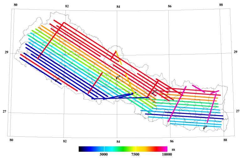
5 .Flight Details
6 ..Flight Details Turbulence and mountain winds were challenging when flying in mountainous area. Combination of high mountains and strong jet streams (100 + knots from WNW) made the flights a serious challenge. Despite these serious challenge acquisition of gravity data was successfully accomplished.
7 Flight Elevations
8 Survey Equipments Used The survey equipments installed consists of: OY-CKP Beachcraft 200 LaCoste & Romberg Air/Sea gravimeter S-38 Chekan AM- 25 airborne gravimeter Javad Lexon GPS receivers (aircraft) Javad Delta GPS receivers (Aircraft and aircraft ground reference)
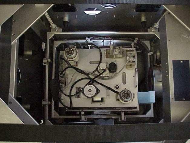

9 ..Equipments used
10 GPS Data Processing and Reference Station GPS reference station was referred to the station in Kathmandu Airport. GPS reference station co-ordinates were obtained by using AUSPOS GPS service provided by Geoscience Australia. Coordinate were given in ITRF 2005 frame. Aircraft Trajectories were computed with the waypoint software package from NovAtel (Calgary, Canada) using precise ephemerides from International GNSS service (
11 Gravity Ties for airborne survey Military Apron reference gravity point was tied to three absolute gravity stations. KATHMANDU J (Airport), KATHMANDU AGB-2 (Survey Dept.), Absolute Gravity station(nagarkot) LaCoste and Romberg G-meter serial no G-466 wasusedfortheseties. Airport G- Value (IGSN71) Sigma TIA, Ktm., Military Apron mgal 0.02
12 AirborneGravityProcessing Gravity results in this compilation are based solely on data from LaCoste & Romberg Gravimeter. Free-air gravity anomalies at aircraft level are obtained from: g = f z where, f z 2 '' γ γ 0 h + δgeotvos + δgtilt + g0 γ 0 ( ( h N) + ( h N) 2 h h 2 ) g f z f z0 δg eotvos δg tilt Free air gravity anomaly Gravimeter observation Apron based gravimeter reading Correction computed by the formula of Harlan Correction computed for tilt g 0 γ 0 N h '' h Apron gravity Value Normal Gravity Geoid undulation(egm08) GPS Ellipsoidal height GPS vertical acceleration
13 Data Validation Anomalies at the flight altitude Anomalies reduced for terrain Anomalies reduced for terrain and downward continued to 6600m Number of line crossings RMS m Gal m Gal mgal
14 ..Data Validation Final dataset composed of 104 line intersections. Analysis of the misfit at the crossing point showed a RMS value of 12.1mGal. Misfit is mainly due to variation in altitude and many lines are as much as 5 kmapart. RMS value reduces to 7.3 mgal after the effect of the terrain was removed and further reduces to 4.6 mgal when downward continued to a common level of 6600m. 4.6 mgal cross over error indicates a 3.2 mgal noise level on individual survey Lines.

15 Free air anomaly field at flight altitude Gal
16 Summary Airborne gravity Survey was successfully completed in one of the most challenging settings in the world for airborne gravity measurement. The resulting free-air anomalies comes with an noise estimate of 3.2 mgal which is seen as very satisfactory given the challenging condition. There is little or no sign of internal biases in the dataset.
17 The next presentation is on GEOID OF NEPAL FROM AIRBORNE GRAVITY SURVEY
18 What is Geoid? Onlytheoretical,we canneitherseenortouchit. The natural extension of the Mean Sea Level surface under the land mass. The equipotential surface of the Earth s gravity field which bestfitstheglobalmeansealevel.

19 What is Geoid? Reference datum to which topographic heights are referred. The geoid model is actually based on gravity data collected worldwide.
20 Why Geoid? we determine the elevation of any point with reference to the reference geoid at any time. With the help of which we can complete the construction projects (that require elevation data) faster andinlesscost. Height of any prominent peaks can be determined accurately and solve the controversies.
21 Why Geoid? Gravity data is not sufficient in this region. Due to this reason existing global geoid model do not provide the geoid information of required accuracy. So after the dense gravity observation the global geoid model will be improved.
22 GeoidComputation Concept is based on remove-restore technique Anomalous gravity potential T is split into three parts: where, T = T + T + T EGM RTM res T EGM = Anomalous gravity potential of a spherical hormonic model T RTM = Anomalous gravity potential generated by Reisidual terrain model High frequency part of topography computed by prism integration from SRTM height data
23 .Geoid Computaion T res = residual anomalous gravity potential Potential corresponding to the unmodeled part of the residual gravity field. This part of the field is computed by spherical FFT The outcome of this technique is a gravimetric geoid, referring to a global datum: to adapt the geoid to fit the local vertical datum, and to minimise possible long- wave length geoid errors, a fitting of the geoid to GPS control is needed as the final geoid determination step.
24 In the context of Nepal The method used is remove-restore, using EGM08 augmented with GOCE to degree 360 as reference and terrain effects from SRTM(15 ). The software package GRAVSOFT was used for Geoid computations.
25 Airborne Data GRAVSOFT accepts the data format from airborne gravity data set file. Data set file contains following information; Point no, latitude, longitude, height, gravity (g), Free-air anomaly ( g) and time (JD)

26 .Airborne data Free-air anomalies at altitude (mgal) Flight elevations Fig. Free-air anomalies at altittude (10 sec spacing data )
27 .Airborne data Fig. Height of flight tracks (30 sec spacing data)
28 EGM08/GOCE Computation EGM-GOCE gravity anomalies and height anomalies are computed in sandwich grids at 0 and 9 km elevation. We use here remove-restore with a maximal degree of 720; this provide a maximum utilization of possible valid EGM08 data in the China and India. Anconstant geoid bias of 53 cmhas beenadded.

29 ...EGM08/GOCE Computation Fig. EGM08/GOCE reference quasigeoid (degree 720)
30 Land gravity data Land gravity data used in geoid computations: 1 st order gravity data (First order control points with g-values). Corrected Coordinated gravity data (Points in both low lands and mountains with a mix of GPS and levelled heights). BGI data (Mainly covering a profile from the Indian border through Kathmandu to Mt. Everest (Kano, 1974 data). Combined data set contains 1114 points.

31 Nepal Geoid Fig. Bouguer anomalies in Nepal from airborne and EGM-GOCE, with location of surface data.
32 Geoid Determination Geoid is obtained by following steps : 1. Downward continuation of airborne data from height to terrain level. 2. The downward continued gravity on the geoid is converted to quasi-geoid heights at terrain-level(ζ) by spherical FFT. 3. The terrain effects n_rtm are added. 4. EGM08 effects is added. This yields the quasigeoid at sealevel. 5. The final gravimetric geoid is thus obtain by adding the correction N-ζ* yielding the final classical geoid.
33 ...Geoid Determination Based on above data the best geoid is calculated and given the name (nepal_geoid_oct2011.gri). It is accessible with user-friendly interpolation software(grid_int) along with GRAVSOFT software.

34 ...Geoid Determination Fig. grid_int software interface
35 Summary of the Project Airborne Surveyed Data set of entire Nepal. Geoid computation interface Preliminary Geoid: nepal_geoid_oct2011.gri : needs some minor adjustments

36 Final geoid of Nepal Fig. Final geoid of Nepal (2 m contours)

37 3D view of geoid of Nepal Fig. 3D view of geoid of Nepal.
38 Conclusion The Geoid information can serve not only for mapping, but also for scientific researches such as: earthquake prediction, geophysical changes and crustal deformation. A determination of Geoid create a precise reference vertical height datum. After the determination of geoid, GPS can be used to determine the physical height; without the conventional levelling method.

39 Mount Everest...

40 Mount Everest...

41 Mount Everest...

42 Mount Everest...
43
PGM2016: A new geoid model for the. Philippines
 PGM2016: A new geoid model for the Philippines United Nations/Nepal Workshop on the Applications of Global Navigation Satellite Systems Kathmandu, Nepal December 12-16, 2016 Ronaldo Gatchalian, Chief Geodesy
Final composite report
 Conduct aerial gravity survey countrywide for height component of the geodetic network Final composite report Part 1: Final gravity acquisition and processing report Part 2: Geoid model for Tanzania from
Presented at the FIG Congress 2018, May 6-11, 2018 in Istanbul, Turkey
 Presented at the FIG Congress 2018, May 6-11, 2018 in Istanbul, Turkey A Geoid model of northern Chile from airborne and surface gravity Geographic Description of Chile. Total Surface: 2,006,096 Km 2.
D DAVID PUBLISHING. Towards a New Geoid Model of Tanzania Using Precise Gravity Data. 1. Introduction. Selassie David Mayunga
 Journal of Environmental Science and Engineering A 5 (2016) 267-276 doi:10.17265/2162-5298/2016.05.005 D DAVID PUBLISHING Towards a New Geoid Model of Tanzania Using Precise Gravity Data Selassie David
Precise Hong Kong Geoid HKGEOID-2000
 Yong-Qi Chen 1, Zhicai Luo 1 and Simon Kwok 2 1.Department of Land Surveying and Geo-Informatics, The Hong Kong olytechnic University 2 Geodetic Survey Section, Lands Department, HKSAR Abstract: This paper
The first high-precision gravimetric geoid of Hungary: HGG2013
 Server on Geodesy, Seismology and Environmental Sciences Published Online 2013 (http://airy.ual.es/) The first high-precision gravimetric geoid of Hungary: HGG2013 Abstract V. Corchete Higher Polytechnic
Evaluation of the Earth Gravity Model EGM2008 in Algeria
 Evaluation of the Earth Gravity Model EGM2008 in Algeria BENAHMED DAHO S. A. National Centre of Space Techniques, Geodetic Laboratory - BP 13 Arzew - 31200 - Algeria. E-mail: d_benahmed@hotmaii.com /Fax:
Coastal geoid improvement using airborne gravimetric data in the United Arab Emirates
 International Journal of Physical Sciences Vol. 7(45), pp. 6012-6023, 30 November, 2012 Available online at http://www.academicjournals.org/ijps DOI: 10.5897/IJPS12.413 ISSN 1992-1950 2012 Academic Journals
Preliminary geoid mapping results by Fugro s improved Micro-g LaCoste turnkey airborne gravity system
 J. Geod. Sci. 2015; 5:80 96 Research Article Open Access D. Zhong* and R. W. Kingdon Preliminary geoid mapping results by Fugro s improved Micro-g LaCoste turnkey airborne gravity system DOI 10.1515/jogs-2015-0009
Detailed Geoid Model for Africa Final Report
 Detailed Geoid Model for Africa Final Report Hussein A. Abd-Elmotaal Minia University, Faculty of Engineering Civil Engineering Department Egypt abdelmotaal@lycos.com 1. Over View This report summaries
New gravimetric quasigeoid of Slovakia
 BOLLETTINO DI GEOFISICA TEORICA ED APPLICATA VOL. 40, N. 3-4, pp. 211-217; SEP.-DEC. 1999 New gravimetric quasigeoid of Slovakia M. MOJZEŠ and J. JANÁK Departament of Theoretical Geodesy, Slovak University
Difference between geoid undulation and quasigeoid height in Hungary
 BOLLETTINO DI GEOFISICA TEORICA ED APPLICATA VOL. 40, N. 3-4, pp. 571-575; SEP.-DEC. 1999 Difference between geoid undulation and quasigeoid height in Hungary J. ÁDÁM Department of Geodesy, Technical University
Numerical solution of the fixed gravimetric BVP on the Earth s surface its possible contribution to the realization of IHRS.
 Numerical solution of the fixed gravimetric BVP on the Earth s surface its possible contribution to the realization of IHRS. Róbert Čunderlík cunderli@svf.stuba.sk Dept. of Mathematics and Descriptive
A Combined DGPS/INS and Synthetic Aperture Radar System for Geoid Referenced Elevation Models and Ortho-Rectified Image Maps
 A Combined DGPS/INS and Synthetic Aperture Radar System for Geoid Referenced Elevation Models and Ortho-Rectified Image Maps C. L. Glennie, K. P. Schwarz and A.M. Bruton, Department of Geomatics Engineering,
Introduction to the use of gravity measurements in Ge111A
 Introduction to the use of gravity measurements in Ge111A Background & basic intuition Data reduction Use of the instrument See Reynolds for detailed quantitative discussion What and Why Gravity measures
REFINED GEOID MODEL FOR THE UNITED ARAB EMIRATES
 REFINED GEOID MODEL FOR THE UNITED ARAB EMIRATES Sahrum Ses 1, Adel Khaleefa and Rene Forsberg 3 1 UTM GNSS and Geodynamics Research Group, Universiti Teknologi Malaysia Military Survey Departments, GHQ
The History and Future of Geoid Modelling at UNB
 The History and Future of Geoid Modelling at UNB Robert Kingdon 1, Petr Vaníček and Marcelo Santos 1 Ph. D. Candidate, Department of Geodesy and Geomatics Engineering, University of New Brunswick, Fredericton,
KEYSTONE PROPERTY GRAVITY GIS DATABASE. Residual Gravity Looking Down to Northwest
 KEYSTONE PROPERTY GRAVITY - 2018 GIS DATABASE Residual Gravity Looking Down to Northwest James L. Wright M.Sc. May 11, 2018 TABLE OF CONTENTS INTRODUCTION......................... 2 SURVEY PROCEDURE......................
GEOID UNDULATIONS OF SUDAN USING ORTHOMETRIC HEIGHTS COMPARED WITH THE EGM96 ANG EGM2008
 GEOID UNDULATIONS OF SUDAN USING ORTHOMETRIC HEIGHTS COMPARED Dr. Abdelrahim Elgizouli Mohamed Ahmed* WITH THE EGM96 ANG EGM2008 Abstract: Positioning by satellite system determine the normal height above
GRAVIMETRIC MAP OF CHILE. Services Mining and Engineering Geophysics Instituto Geográfico Militar
 GRAVIMETRIC MAP OF CHILE Araneda M., Rivas L., Avendaño M, Sottolichio G., Rubio W. Services Mining and Engineering Geophysics segmi@netexpress.cl) Instituto Geográfico Militar (lrivas@igm.cl) Abstract
The National Spatial Reference System of the Future
 The National Spatial Reference System of the Future William Stone Southwest Region (AZ, NM, NV, UT) Geodetic Advisor william.stone@noaa.gov NOAA s National Geodetic Survey geodesy.noaa.gov Salt Lake City
FORMAT FOR TECHNICAL PAPERS
 TOWARDS A MODERNIZED GEODETIC DATUM FOR NEPAL: OPTIONS FOR DEVELOPING AN ACCURATE TERRESTRIAL REFERENCE FRAME FOLLOWING THE APRIL 25, 2015 MW7.8 GORKHA EARTHQUAKE Chris PEARSON 1, Niraj MANANDHA 2 ABSTRACT
GRAVITY SURVEY TEELS MARSH PROSPECT
 GRAVITY SURVEY over the TEELS MARSH PROSPECT MINERAL COUNTY, NV for Dajin Resources (US) Corp. March 2015 SUBMITTED BY Magee Geophysical Services LLC 465 Leventina Canyon Road Reno, Nevada 89523 USA TEL
Status of the European Gravimetric Quasigeoid
 Status of the European Gravimetric Quasigeoid C. Voigt, H. Denker {voigt,denker}@ife.uni-hannover.de 1 Introduction 2 The European Gravity and Geoid Project (EGGP) 3 Data Sets 4 Quasigeoid Computation
The GOCE Geoid in Support to Sea Level Analysis
 The GOCE Geoid in Support to Sea Level Analysis The geoid is a very useful quantity for oceanographers Thomas Gruber Astronomical & Physical Geodesy (IAPG) Technische Universität München 1. Characteristics
Gravity data reduction
 Gravity data reduction REDUCTION: raw data à gravity anomaly data Temporal corrections tides and instrument drift Spatial corrections latitude and elevation GRS67 = gravity variation with latitude at sea
Precision geoid determination by spherical FFT in and around the Korean peninsula
 Earth Planets Space, 51, 13 18, 1999 Precision geoid determination by spherical FFT in and around the Korean peninsula Hong-Sic Yun Department of Civil Engineering, Sungkyunkwan University, Korea (Received
A Geoid Model Of Northern Chile From Airborne And Surface Gravity
 A Geoid Model Of Northern Chile From Airborne And Surface Gravity Julio NEIRA and Cristian Carrasco, Chile Key words: Geoid, Airborne Gravity, Geodesy, Gravimetry SUMMARY In recent decades many countries
Arctic Ocean Mean Sea Surface, Geoid and Gravity from Surface Data, Icesat and GRACE a reference for Cryosat sea-ice mapping
 Arctic Ocean Mean Sea Surface, Geoid and Gravity from Surface Data, Icesat and GRACE a reference for Cryosat sea-ice mapping R. Forsberg and H. Skourup, Geodynamics Dept., DNSC rf@spacecenter.dk Arctic
Evaluation and Improvement of the EGG97 Quasigeoid Model for Europe by GPS and Leveling Data
 Evaluation and Improvement of the EGG97 Quasigeoid Model for Europe by GPS and Leveling Data Heiner Denker Institut für Erdmessung, Universität Hannover, Schneiderberg 50, D-30167 Hannover, Germany E-mail:
National Report of Sweden
 National Report of Sweden NKG geoid WG meeting Jonas Ågren jonas.agren@lm.se Jonas Ågren, 2010-03-09, Masala Summary of Swedish geoid activities Updated GNSS/levelling observations. New gravimetric quasigeoid
(1) , 6WHYH.HQ\RQ (2) *HRG\QDPLFV 'HSW 1DWLRQDO 6XUYH\ DQG &DGDVWUH 5HQWHPHVWHUYHM '. &RSHQKDJHQ 19 'HQPDUN UI#NPV GN
 , 6WHYH.HQ\RQ (2) *HRG\QDPLFV 'HSW 1DWLRQDO 6XUYH\ DQG &DGDVWUH 5HQWHPHVWHUYHM '. &RSHQKDJHQ 19 'HQPDUN UI#NPV GN") *5$9,7
*5$9,7
A Study on Precise Local Gravity Field Modelling
 A Study on Precise Local Gravity Field Modelling R. Čunderlík 1, J. Papčo 2, P. Záhorec 3 cunderli@svf.stuba.sk, juraj.papco@stuba.sk, zahorec@savbb.sk 1 Dept. of Mathematics and Descriptive Geometry,
m and km baseline with a standard deviation of relative to EGM08 and levelling, respectively ( 10 is approximately equivalent to 1mm of
 An Absolute Geopotential Height System for Ethiopia Tulu Besha Bedada A thesis submitted in fulfilment of the requirements for the degree of Doctor of Philosophy to the University of Edinburgh Abstract
A Preliminary Attempt of a Quasi-Geoid for Saudi Arabia
 A Preliminary Attempt of a Quasi-Geoid for Saudi Arabia Saad MOGREN, Saudi Arabia Key words: Geoid, Saudi Arabia, SUMMARY This proposal describes the need to undertake a national geoid (quasi-geoid) model
GEOID UNDULATION DIFFERENCES BETWEEN GEOPOTENTIAL. RICHARD H. RAPP and YAN MING WANG
 GEOID UNDULATION DIFFERENCES BETWEEN GEOPOTENTIAL MODELS RICHARD H. RAPP and YAN MING WANG Department of Geodetic Science and Surveying, The Ohio State University, Columbus, Ohio, U.S.A. (Received 15 September,
A new geoid model for Bhutan. Machiel Bos Rui Fernandes
 A new geoid model for Bhutan Machiel Bos (machiel@segal.ubi.pt) Rui Fernandes (rui@segal.ubi.pt) June 2015 1 Definition of heights June 2015 2 Purpose of a geoid model Orthometric heights are the official
Proceedings of the First International Conference on Civil Engineering, Assiut University, Volume 2, pp , October 7-8.
 Proceedings of the First International Conference on Civil Engineering, Assiut University, Volume 2, pp. 246-253, October 7-8. PRODUCTIVE GPS TOPOGRAPHIC MAPPING FOR NATIONAL DEVELOPMENT PROJECTS IN EGYPT
Outline. Shape of the Earth. Geographic Coordinates (φ, λ, z) Ellipsoid or Spheroid Rotate an ellipse around an axis. Ellipse.
 Ellipsoid or Spheroid Rotate an ellipse around an axis. Ellipse.") Map Projections Outline Geodesy and map projections Prof. D. Nagesh Kumar Department of Civil Engineering Indian Institute of Science Bangalore 560 012, India http://www.civil.iisc.ernet.in/~nagesh Shape
Map Projections Outline Geodesy and map projections Prof. D. Nagesh Kumar Department of Civil Engineering Indian Institute of Science Bangalore 560 012, India http://www.civil.iisc.ernet.in/~nagesh Shape
Geoid Determination Based on a Combination of Terrestrial and Airborne Gravity Data in South Korea
 Geoid Determination Based on a Combination of Terrestrial and Airborne Gravity Data in South Korea by Hyo Jin Yang Report No. 507 Geodetic Science The Ohio State University Columbus, Ohio 43210 December
Strategy for the Realization of the International Height Reference System (IHRS)
") Deutsches Geodätisches Forschungsinstitut (DGFI-TUM) Technische Universität München Strategy for the Realization of the International Height Reference System (IHRS) Laura Sánchez 1, Johannes Ihde 2, Roland
Deutsches Geodätisches Forschungsinstitut (DGFI-TUM) Technische Universität München Strategy for the Realization of the International Height Reference System (IHRS) Laura Sánchez 1, Johannes Ihde 2, Roland
On Determination of a Regional Vertical Datum by Combination of EGM, Local Gravity and GPS/leveling Data
 On Determination of a Regional Vertical Datum by Combination of EGM, Local Gravity and GPS/leveling Data Pavel NOVÁK, Czech Republic Key words: geodetic heights, orthometric heights, normal heights, geoid,
Improved Official Geoid Model for Israel, 2008
 Hezi SARID, Hsein NASR-ALDIN and Dan SHARNI, Israel Key words: geoid, undulation, EGM2008, WGS84, gravity anomaly SUMMARY The Survey of Israel (SOI) has 849 anchor-points, where orthometric and ellipsoidal
Activities in South America: Gravity and Geoid Projects
 Activities in South America: Gravity and Geoid Projects Segundo Taller de Grupo de Trabajo I SIRGAS Montevideo - Uruguay May 26 a 30, 2008 Maria Cristina Pacino Universidade de Rosário CGED - IBGE Denizar
Calibration/validation of GOCE data by terrestrial torsion balance observations
 Calibration/validation of GOCE data by terrestrial torsion balance observations Gy. Tóth 1, J. Ádám 1, L. Földváry 1,4, I.N. Tziavos 2, H. Denker 3 1 Department of Geodesy and Surveying, Budapest University
Consideration of a Global Vertical Reference System (GVRS) in the IERS Conventions
 in the IERS Conventions") Consideration of a Global Vertical Reference System (GVRS) in the IERS Conventions Johannes Ihde Federal Agency for Cartography and Geodesy (BKG) Chair of IAG ICP1.2 (2003-2007) Vertical Reference Frames
Consideration of a Global Vertical Reference System (GVRS) in the IERS Conventions Johannes Ihde Federal Agency for Cartography and Geodesy (BKG) Chair of IAG ICP1.2 (2003-2007) Vertical Reference Frames
Last week we obtained a general solution: 1 cos αdv
 GRAVITY II Surface Gravity Anomalies Due to Buried Bodies Simple analytical solution may be derived for bodies with uniform density contrast simple shape, such as: Sphere Horizontal/vertical cylinders
A gravimetric quasi-geoid evaluation in the Northern region of Algeria using EGM96 and GPS/Levelling
 A gravimetric quasi-geoid evaluation in the Northern region of Algeria using EGM96 and GPS/Levelling Mohamed Aissa MESLEM Laboratory of geodesy Department of Research and Development National Institute
Progress Towards a Centimeter Geoid for Dubai Emirate
 Progress Towards a Centimeter Geoid for Dubai Emirate Y. AL MARZOOQI, H. FASHIR and Syed Iliyas AHMED, Dubai, United Arab Emirates and R. FORSBERG and G. STRYKOWSKI, Denmark Key words: GPS, Gravity, Geoid,
A two-step point mass method for regional gravity field modeling: a case study over the Auvergne test area
 A two-step point mass method for regional gravity field modeling: a case study over the Auvergne test area - Geodätische Woche 2014 - Session 2 - Schwerefeld und Geoid Miao Lin, Heiner Denker, Jürgen Müller
Introduction to the use of gravity measurements
 Introduction to the use of gravity measurements Background & basic intuition Data reduction Use of the instrument See Reynolds, Chpt 2, for detailed quantitative discussion What and Why Gravity measures
Gravity in the Ryukyu Arc*
 Journal of the Geodetic Society of Japan Vol. 22, No. 1, (1976), pp. 23-39 Gravity in the Ryukyu Arc* Jiro SEGAWA Ocean Research Institute, University of Tokyo (Received March 31, 1976; Revised May 22,
IGFS Structure Director : Rene Forsberg
 IGFS Structure Director : Rene Forsberg International Gravimetric Bureau (BGI) Director S. Bonvalot International Geoid Service (IGeS) Director R. Barzaghi International Center for Global Earth Models
Dependences in the pillar Earth s gravity field of
 Reports on Geodesy, vol. 92, no. 1, 2012 Dependences in the pillar Earth s gravity field of GGOS - description using UML notation Małgorzata Paśnicka 1, Karolina Szafranek 2, Agnieszka Zwirowicz Rutkowska
ESTIMATING THE RESIDUAL TROPOSPHERIC DELAY FOR AIRBORNE DIFFERENTIAL GPS POSITIONING (A SUMMARY)
") ESTIMATING THE RESIDUAL TROPOSPHERIC DELAY FOR AIRBORNE DIFFERENTIAL GPS POSITIONING (A SUMMARY) J. Paul Collins and Richard B. Langley Geodetic Research Laboratory Department of Geodesy and Geomatics
ESTIMATING THE RESIDUAL TROPOSPHERIC DELAY FOR AIRBORNE DIFFERENTIAL GPS POSITIONING (A SUMMARY) J. Paul Collins and Richard B. Langley Geodetic Research Laboratory Department of Geodesy and Geomatics
National Geodetic Survey
 Geodesy, Geoids, and Vertical Datums: A Perspective from te U.S. ational Geodetic Survey Daniel R. ROMA, Yan Ming WAG, Jarir SALEH, and Xiaopeng LI Paper 3768 ational Geodetic Survey An Office wit te ational
Global vertical datum unification based on the combination of the fixed gravimetric and the scalar free geodetic boundary value problems
 Global vertical datum unification based on the combination of the fixed gravimetric and the scalar free geodetic boundary value problems Laura Sánchez contribution to the IAG-IC.: Vertical Reference Frames
Development of a Borehole Gravity Meter for Mining Applications
 Ground and Borehole Geophysical Methods Paper 111 Development of a Borehole Gravity Meter for Mining Applications Seigel, H. O. [1], Nind, C. [1], Lachapelle, R. [1], Chouteau, M. [2], Giroux, B. [2] 1.
CENTIMETRE LEVEL OF ACCURACY OF QUASIGEOID MODEL IN POLAND
 CENTIMETRE LEVEL OF ACCURACY OF QUASIGEOID MODEL IN POLAND Jan Krynski Institute of Geodesy and Cartography, Poland krynski@igik.edu.pl Adam Lyszkowicz University of Warmia and Mazury in Olsztyn, Poland
Total gravitational field is sum of contributions from all masses.
 Gravity force (acceleration) vs potential (energy) acceleration (g) => GM/r 2 Potential => - GM/r G is Newton s gravitational constant 6.67x10⁻¹¹ (S.I. units) you should determine what the S.I. units are
NGS is Scheduled to Replace NAVD 88 and NAD 83 In 2022
 NGS is Scheduled to Replace NAVD 88 and NAD 83 In 2022 Indiana Society of Professional Land Surveyors Conference January 2017 John Ellingson NGS Geodetic Advisor john.ellingson@noaa.gov 202-306-6904 1
Regional quasigeoid solution for the Moldova area from GPS/levelling data
 Regional quasigeoid solution for the Moldova area from GPS/levelling data A. MARCHENKO 1 I. MONIN 1 National University Lviv Polytechnic Institute of Geodesy Lviv Ukraine email: march@polynet.lviv.ua The
Preliminary study of the Gravimetric Local Geoid Model in Jordan: case study (GeoJordan Model)
") ANNALS OF GEOPHYSICS, VOL. 50, N. 3, June 2007 Preliminary study of the Gravimetric Local Geoid Model in Jordan: case study (GeoJordan Model) Omar Al-Bayari and Abdallah Al-Zoubi Department of Surveying
ANNALS OF GEOPHYSICS, VOL. 50, N. 3, June 2007 Preliminary study of the Gravimetric Local Geoid Model in Jordan: case study (GeoJordan Model) Omar Al-Bayari and Abdallah Al-Zoubi Department of Surveying
EPUSP. ( Escola Politécnica da Universidade de São Paulo
 EPUSP Escola Politécnica da Universidade de São Paulo Present and Future of the gravity surveys and geoid model in South America Denizar Blitzkow Ana Cristina Oliveira Cancoro de Matos Gabriel do Nascimento
Digital Zenith Camera for Geodetic Purposes in Latvia
 Digital Zenith Camera for Geodetic Purposes in Latvia Janis Kaminskis, Inese Janpaule, Ansis Zarins Presented by Jānis Kaminskis Development of a digital zenith telescope optical system and telescope prototype
THE SITUATION IN EASTERN EUROPE ABOUT GEOID / QUASIGEOID MODELS DETERMINATION
 THE SITUATION IN EASTERN EUROPE ABOUT GEOID / QUASIGEOID MODELS DETERMINATION Petre Iuliu DRAGOMIR, Professor, PhD Technical University of Civil Engineering Bucharest, Faculty of Geodesy, pdragomir@rdslink.ro
Geographic Information Systems class # 1 February 19, Coordinate reference systems in GIS: geodetic coordinates
 Geographic Information Systems class # 1 February 19, 2013 Coordinate reference systems in GIS: geodetic coordinates Manuel Campagnolo ISA Manuel Campagnolo (ISA) GIS/SIG 2012 2013 February 19, 2013 1
USING LIDAR MEASUREMENTS FOR IMPROVING OR UP-DATING A DEM
 JAES_1(14)_3_2011 VAIS M. et. all, pp.123-128 SECTION Geodesic Engineering USING LIDAR MEASUREMENTS FOR IMPROVING OR UP-DATING A DEM VAIS Manuel*, IOSIF Gheorghe, Bucharest University, *e-mail: manuel.vais@sipg.ro
GEOIDS FAQ. November
 GEOIDS FAQ 1. What is a geoid? A geoid is a representation of the equipotential surface of the Earth s gravity field. It can be thought of as a surface coinciding with the undisturbed mean sea level extended
Report for 15th PCGIAP Meeting at 18th UNRCC-AP Working Group 1 Regional Geodesy
 Report for 15th PCGIAP Meeting at 18th UNRCC-AP Working Group 1 Regional Geodesy Chairman Shigeru Matsuzaka, Japan - shigeru@gsi.go.jp Vice Chairman Prof. Pengfei Cheng, China - chengpf@casm.ac.cn John
Height systems. Rudi Gens Alaska Satellite Facility
 Rudi Gens Alaska Satellite Facility Outline Why bother about height systems? Relevant terms Coordinate systems Reference surfaces Geopotential number 2 Why bother about height systems? give a meaning to
Part : General Situation of Surveying and Mapping. The Development of Surveying and Mapping in China. The contents
 The Development of Surveying and Mapping in China Dr. Ping Xiao China.P.R The contents Part : General Situation of Surveying and Mapping 1. The legal systems of surveying and mapping 2. The technologies
Height Modernization 2013 A New Canadian Vertical Datum
 Height Modernization 2013 A New Canadian Vertical Datum What is Height Modernization? The Height Reference System Modernization is a project at the Geodetic Survey Division (GSD) of Natural Resources Canada
Height System Unification with GOCE
 Height System Unification with GOCE North American Analyses and Main Results M.G. Sideris and E. Rangelova University of Calgary Overview of the UoC contributions Tailored GOCE model Computing MSL at Canadian
Case study of Japan: Reference Frames in Practice
 Case study of Japan: Reference Frames in Practice Basara Miyahara and Koji Matsuo Sponsors: 1 Outline Introduction - Geodetic reference frame of Japan - GEONET : continuous GNSS observation system Geometric
r 1 r 2 r 3 Dr is what matters!
 Today s Agenda Gravity - Background & basic intuition - Data reduction - Use of the instrument - See textbook for detailed quantitative discussion - Measure height of Millikan or S. Mudd What and Why Gravity
GRACE Gravity Model GGM02
 GRACE Gravity Model GGM02 The GGM02S gravity model was estimated with 363 days (spanning April 2002 through December 2003) of GRACE K-band range-rate, attitude, and accelerometer data. No Kaula constraint,
New satellite mission for improving the Terrestrial Reference Frame: means and impacts
 Fourth Swarm science meeting and geodetic missions workshop ESA, 20-24 March 2017, Banff, Alberta, Canada New satellite mission for improving the Terrestrial Reference Frame: means and impacts Richard
On Ambiguities in Definitions and Applications of Bouguer Gravity Anomaly
 Chapter 3 On Ambiguities in Definitions and Applications of Bouguer Gravity Anomaly P. Vajda, P. Vaníček, P. Novák, R. Tenzer, A. Ellmann, and B. Meurers Abstract Over decades diverse definitions and use
Gravimetry data validation in Algeria
 BOLLETTINO DI GEOFISICA TEORICA ED APPLICATA VOL. 40, N. 3-4, pp. 205-210; SEP.-DEC. 1999 Gravimetry data validation in Algeria S.A. BENAHMED DAHO and S. KAHLOUCHE National Centre of Spatial Techniques,
Accuracy Assessment of the Gravitational Geoid Model of Hilla Area, Iraq
 International Journal of Current Engineering and Technology E-ISSN 2277 4106, P-ISSN 2347 5161 2016 INPRESSCO, All Rights Reserved Available at http://inpressco.com/category/ijcet Research Article Accuracy
Tailored High-Degree Geopotential Model for Egypt
 Tailored High-Degree Geopotential Model for Egypt Hussein A. Abd-Elmotaal and Mostafa Abd-Elbaky Civil Engineering Department, Faculty of Engineering, Minia University, Minia 61111, Egypt abdelmotaal@lycos.com
Height systems. Rüdiger Gens
 Rüdiger Gens 2 Outline! Why bother about height systems?! Relevant terms! Coordinate systems! Reference surfaces! Geopotential number! Why bother about height systems?! give a meaning to a value defined
Updating and Re-establishment of Cadastral Control Points in Korea by Using GPS Observations
 Updating and Re-establishment of Cadastral Control Points in Korea by Using GPS Observations YANG Chul-Soo, Korea Key words: GPS, cadastral control point, datum transformation, network adjustment SUMMARY
Vertical Reference Frame Pacific
 Vertical Reference Frame Pacific Andrick Lal SPC Geoscience Division GIS&RS User Conference 29 th November 2016 USP, Fiji. What does it mean? All buildings and features have a height. But what is it relative
Modernization of National Geodetic Datum in China *
 UNITED NATIONS E/CONF.102/IP.16 ECONOMIC AND SOCIAL COUNCIL Nineteenth United Nations Regional Cartographic Conference for Asia and the Pacific Bangkok, 29 October 1 November 2012 Item 6(b) of the provisional
Case Study of Australia
 Case Study of Australia John Dawson, Geoscience Australia 1 Australia s Geodetic eco-system Geocentric Coordinates Observing Infrastructure Height Datum Geoid Models Tools Services Standards 2 Australia
THE DEAD SEA RIFT VALLEY
 JOINT ISRAELI-PALESTINIAN GRAVITY SURVEY IN THE DEAD SEA RIFT VALLEY by M. Rybakov The Geophysical Institute of Israel P.O. Box 182 Lod, 7 1 100 Israel R El-Kelani Earth Sciences and seismic engineering
TOWARDS ROBUST LOCALIZATION OF RTK-GPS TOPOGRAPHIC SURVEYS 23
 TOWARDS ROBUST LOCALIZATION OF RTK-GPS TOPOGRAPHIC SURVEYS Jerry W. Nave, North Carolina A&T University; Tarig A. Ali, American University of Sharjah Abstract Localization is performed to fit the observed
GPS Surveying Dr. Jayanta Kumar Ghosh Department of Civil Engineering Indian Institute of Technology, Roorkee. Lecture 06 GPS Position
 GPS Surveying Dr. Jayanta Kumar Ghosh Department of Civil Engineering Indian Institute of Technology, Roorkee Lecture 06 GPS Position Friends! Welcome you to sixth class on GPS surveying. Today, I am going
Mobile Mapping Tips and Tricks
 Mobile Mapping Tips and Tricks Projections, Datums and Geoids, May 2017 Introduction This guide is designed to provide a basic understanding of coordinate system projections, datums and geoids. The guide
OUTLINE. Many of us secretly dream of six months without gravity COURSE DESCRIPTION
 GEOL 481.3 OUTLINE POTENTIAL FIELD METHODS GEOL 481.3 email: jim.merriam@usask.ca POTENTIAL FIELD METHODS Many of us secretly dream of six months without gravity Allan Fotheringham COURSE DESCRIPTION This
Establishment of a Global Absolute Gravity Network
 Establishment of a Global Absolute Gravity Network H. Wilmes 1), H. Wziontek 1), R. Falk 1), J. Ihde 1), S. Bonvalot 2), R. Forsberg 3), S. Kenyon 4), L. Vitushkin 5) 1) Federal Agency for Cartography
Modern Navigation. Thomas Herring
 12.215 Modern Navigation Thomas Herring Today s Class Latitude and Longitude Simple spherical definitions Geodetic definition: For an ellipsoid Astronomical definition: Based on direction of gravity Relationships
The PaTrop Experiment
 Improved estimation of the tropospheric delay component in GNSS and InSAR measurements in the Western Corinth Gulf (Greece), by the use of a highresolution meteorological model: The PaTrop Experiment N.
Keywords: ASTER, SRTM, Digital Elevation Model, GPS-Levelling data, Validation.
 www.sgem.org ACCURACY ASSESSMENT OF ASTER AND SRTM DIGITAL ELEVATION MODELS: A CASE STUDY IN TURKEY H. Tugba Arli IL 1 Dr. R. Alpay ABBAK 2 1 Ministry of Health - Turkey 2 Selcuk University - Turkey ABSTRACT
Fitting Gravimetric Local and Global Quasi-Geoids to GPS/Levelling Data: The Role of Geoid/Quasi-Geoid Variations
 JKAU: Eng. Sci., Vol.20 No.1, pp: 47-59 (2009 A.D. / 1430 A.H.) Fitting Gravimetric Local and Global Quasi-Geoids to GPS/Levelling Data: The Role of Geoid/Quasi-Geoid Variations Gomaa M. Dawod (1, 2) and
Application of variance components estimation to calibrate geoid error models
 DOI 10.1186/s40064-015-1210-5 RESEARCH Open Access Application of variance components estimation to calibrate geoid error models Dong Mei Guo * and Hou Ze Xu *Correspondence: guodongmei67@163.com State
Comparing 10 Different Interpolation Methods Used to Determine Geoidquasigeoid Separation (Case Study in Iran)
") J. Basic. Appl. Sci. Res., 2(8)8292-8299, 2012 2012, TextRoad Publication ISSN 2090-4304 Journal of Basic and Applied Scientific Research www.textroad.com Comparing 10 Different Interpolation Methods Used
J. Basic. Appl. Sci. Res., 2(8)8292-8299, 2012 2012, TextRoad Publication ISSN 2090-4304 Journal of Basic and Applied Scientific Research www.textroad.com Comparing 10 Different Interpolation Methods Used
IMPROVING GEOID DETERMINATION OVER MOROCCO AREA USING GOCE LEVEL 2 DATA
 IMPROVING GEOID DETERMINATION OVER MOROCCO AREA USING GOCE LEVEL 2 DATA EL Hassan EL BRIRCHI (1), Driss EL AZZAB (2) (1) Hassania School of Public Works, km 7, Route d El Jadida B.P 8108 Oasis Casablanca