An Overview of the Tapia Canyon Field Static Geocellular Model and Simulation Study
|
|
|
- Martha Chambers
- 6 years ago
- Views:
Transcription
1 An Overview of the Tapia Canyon Field Static Geocellular Model and Simulation Study Prepared for Sefton Resources Inc. Jennifer Dunn, Chief Geologist Petrel Robertson Consulting Ltd.
2 Outline Background Definition of a Static Geocellular Model Methodology for Model Creation Reviewing inputs Interpretation Model finalization Work to date Preparation for simulation software Conversion to a Dynamic Model History match Expected Timeframe Definition of the Simulation Process Expected Timeframe Expected Outcomes
3 Background To date, three static geocellular models have been created in the Tapia Canyon Field by Petrel Robertson Consulting: Hartje - Central Fault block 2011 Full Field Model 2012 Revised Full Field Model Steam Flood Simulation efforts on these models are underway and expected to be complete in Steam Flood Simulation is being conducted in CMG STARS TM software by Dr. Farouq Ali.

4 This is a 3D view of the 2011 Full Field Model
5 Modelling and Simulation work are complex and iterative process This presentation seeks to outline: The modelling process Project timeframes Simulation efforts Figure from Riordan, 2009
6 Definition of a Static Geocellular Model A static geocellular model captures a snapshot of the field at a moment in time -Usually the initial conditions of the field before production A geologic model incorporates all known and interpreted geologic and geophysical data available to the modelling team It can be a product in itself, useful for well planning for example It can be a basis for simulation efforts It is a 3-Dimensional grid representing the field separated into many tens of thousands of grid data cells. The data in each cell is a representation of the properties of the rock and fluids at that point in space.
7 An overview of the Tapia Canyon Field. This type of map is one form of input into a geologic model. This map is limited to the field area, but as models need to include reservoir geology and geologic constraints for accurate simulation results, the full field model covers a larger area than this map.
8 Methodology Petrel Robertson Consulting uses Petrel TM software, an industry leading modelling product created by Schlumberger Inputs into the model must first be validated Data are then interpreted The model is created by our team of geocellular modelling specialists. Our geomodellers have a background in geology, and familiarity with geostatistics and geophysics this particular case also used a specialist in clastic sedimentology (the Tapia Field s oil is contained within a clastic rock)
9 Methodology Reviewing Inputs Before the model can be created, data need to be understood and qualified In 2011, as part of the Hartje and Full Field Models, Petrel Robertson Consulting Reviewed and petrophysically interpreted 73 wells to get a complete geologic picture adequate for simulation Well data were of varying quality which affected the modelling process Well data had to be digitized, and then interpreted, this included: Calculating porosity Calculating water and oil saturation Verifying formation tops The complexity, amount and quality of the data will control how long this process takes in this case about a three month s total time prior to model creation (Jan-April 2011)

10 An example of the Petrophysical analysis conducted prior to model creation. This allows an understanding of porosity, water saturations, and lithologies - all of which are necessary inputs to the model.
11 Methodology - Interpretations Formation tops from well logs are used to interpret structure and faulting This is a basic skeleton for the model a grid showing where the faults are interpreted. Lack of seismic data makes this interpretation more difficult and can be a potential source of error and iteration for the modelling and simulation process.

12 Well data are used to create maps for each key surface. This map is the same surface as shown earlier in the presentation. It illustrates the increased scope of the model and also minor differences in interpretation. Structural elevation map of the top of the Yule Formation in feet above mean sea level. Faults are shown in red.
13 Methodology - Interpretations Production data are incorporated to help with fault interpretation and fluid contact interpretation The varying contacts help define which fault blocks are connected within the field. Steam flood simulation work will be essential for helping define faults.
14 Methodology Interpretations Distribution of Reservoir Facies are interpreted. This process requires geologic interpretation and the results of the petrophysical analysis. Each facies has a calculated range of porosity and permeability determined from core and log analysis, and modelled with geostatistics.
15 Methodology - Interpretations Core and Petrophysical data are used to understand the porosity relationship with facies, so the distribution of porosity within the field can be modelled. The Yule Formation sands are heterogeneous in nature, with wide variations in grain size and poor sorting. This makes the distribution of porosity difficult to predict, and as such, why modelling is so important. NW-SE Cross-Section Porosity


16 Methodology - Interpretations Core and Petrophysical data are used to understand the permeability relationship with porosity, so the distribution of permeability within the field can be modeled. The relationship between porosity and permeability are calculated based on core analysis, however, simulation results have been helpful in improving the permeability model. NW-SE Cross-Section Permeability K-max (md) NW-SE Cross-Section Porosity
17 Methodology Interpretations Water Saturation distribution is calculated from petrophysical analysis combined with facies and porosity distributions Older vintage well logs increase uncertainty in water saturation calculations. This is an area where history matching during simulation may provide valuable input to the geologic model. History matching can be a tedious, timeconsuming process.

18 Layering style Bed continuity termination style, pinch out Relationship of beds with faults offset, continuous, sealing Methodology - Interpretations Depositional style is interpreted:
19 Summary: Methodology - Interpretations Formation tops from well logs are used to understand structure and faulting. Production data are incorporated to help with fault interpretation and fluid contact interpretation. Distribution of Reservoir Facies are interpreted. Core and Petrophysical data are used to understand the porosity and permeability relationships. Water Saturation distribution is calculated from petrophysical analysis combined with facies and porosity distributions. Depositional style is interpreted.
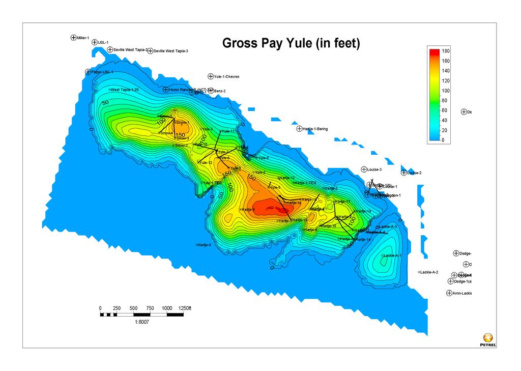
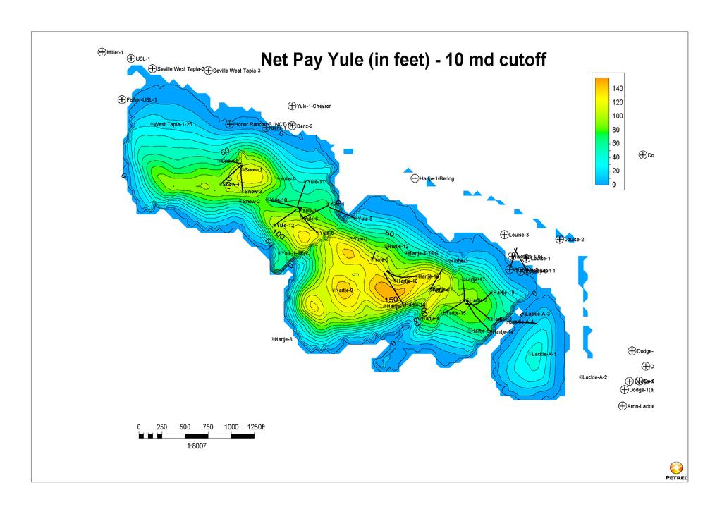
20 Model Finalization Once all of the inputs to the model have been verified and interpreted, the model can be used to generate data meaningful for development: Gross Pay within the Yule Formation Net Pay within the Yule Formation (using a 10mD permeability cutoff) Hydrocarbon Pore Volumes and Original Oil In Place (OOIP) calculations
21
22
23

24 Top down view of a layer within the Yule formation showing well paths
25 Work to Date Three months to process and analyse input data to model One month to create Hartje model One month to iterate with simulation software The Hartje model is small and simplistic, so this process moved quickly The Hartje model is deemed inadequate to render usable simulation results Three months to create Full Field model Drilling program for 2011 commenced, decision was made to incorporate 2011 data prior to finalizing simulation Final data from 2011 wells received in June 2012 Revised Full Field Model signed off in September 2012
26 Preparation of Model for Simulation Geocellular Models are incredibly complex and consist of many cells, each containing multiple pieces of data. The Tapia Canyon Revised Full Field Model contains Over 400,000 cells each 50ft x 50ft in area and a minimum of 1 foot in thickness There are more than 90 layers within the model to represent the Yule Formation Simulation software would be unable to process this volume and complexity of data, so the model is upscaled. Upscaling is a compromise between maintaining the integrity of the geologic interpretation and making simulation efforts possible The upscaled 2012 Revised Full Field model has 186,000 cells The upscaling requirements are dependent on the simulation software, computer hardware and project timeline
27 Conversion to a Dynamic Model A static geocellular model reflects a snapshot of the field at one time initial conditions. A dynamic model reflects the changes to the field through time for example, changes in saturations and contacts related to the effects of production. Simulations predict what will happen to the field in the future under certain conditions This can help understand what may happen during field development. Understanding what has happened in the past (history matching) is critical to success. At this point the upscaled geologic model is imported into the simulation software and conversion to a dynamic model can begin. The dynamic model is created by the simulation engineer.
28 Conversion to a Dynamic Model Engineering and Field data must be added to the static model. This will include production histories, pressure data, etc. Tapia Canyon Field has over 50 years of production history, making incorporating this data incredibly complex. As the Dynamic Model is created, input from the model may guide interpretation and result in changes to the Static Model.
29 Conversion to a Dynamic Model The Dynamic Model may provide data and inform interpretations on: Structure what parts of the field are in pressure communication with each other? Permeability how soon do wells show pressure communication? Water Saturation how quickly do fluid contacts move? or water production increase? Heterogeneity/Anisotropy is there a directionality to the field, or distribution of the porosity and permeability that becomes evident with changes in pressure data? This may result in iterations between the static and dynamic models. It is imperative that the Geomodeller and Simulations Engineer work closely together
30 Conversion to a Dynamic Model: History Matching History matching of the field s production data is a critical step prior to forward looking simulation efforts Iteration with the static model may be required In a field with this much history, this process may be up to 90% of the simulation engineer s work and project timeline History matching is conducted by repeatedly running the simulation software using the combined geologic and engineering data, until the results of the simulation from initial production to present day match. The Tapia Canyon Revised Full Field model contains so much data that each run takes 4-5 days to complete
31 Timeframe Upload of static model and input of engineering data - 1 month History matching of production data may take up to 2 to 3 months (as of November 2012, history matching is underway on the Revised Full Field model) Dynamic model is complete Simulation efforts can begin - up to 3 to 6 months, depending on number of scenarios Multiple development scenarios and variables will be considered to find the best fit for increased recovery with managed costs
32 The Simulation Process Simulation allows a forward look for a field a peek into the future for different development scenarios Once the Dynamic Model is created, various scenarios can be investigated with simulation, including: What are the effects of a continuous steam flood? How much steam would be required for injection and at what pressures? What would be the optimal position of injectors? What incremental recovery could be expected? How much would the different development scenarios cost? Finally development recommendations can be made, looking at the economic value of the different scenarios
33 The Simulation Process Each scenario run within the simulation software may take days to weeks of computer time to complete Most full field optimization simulations will require scenarios to be investigated If alternate scenarios are investigated, this would add to total time. For example What is the incremental recovery of a water flood versus a steamflood? What is the value of continuous steam versus cyclic steam Is there potential for a gas flood? And if so what type of incremental recovery would this provide? What are the economics for each of these different options Completion of Simulation Scenarios may take up to 3-6 months Interpretation of the results will follow
34 Timeframe: Going Forward Completion of the Dynamic Model of the Tapia Canyon Field is almost complete History match in process Simulation scenarios for full field optimization are expected to commence by December of 2012 (after history match completed).


35 Expected Outcome The outcome of simulation and modelling efforts are a robust interpretation of the field and a comprehensive development plan resulting in an optimized, most economic go-forward plan for development 3-D view of complete model with wells
36 APPENDIX

37 2012 Revisions to the Full Field Model Drilling of three new wells verified the robust nature of the model tops were very close to values predicted by 2011 model. Two new core were collected. This allowed: An update to the porosity and permeability models Inclusion of additional core data from the field

38 2012 Revisions to the Full Field Model Permeability Data were further modified to reflect early simulation results. Adjustments were made to more closely match production histories.
39 2012 Revisions to the Full Field Model Updip termination of the field was updated to reflect an interpretation of stratigraphic pinchout, compared with an updip fault termination as used in 2011.
40 Summary: Revisions to Full Field Model Drilling of three new wells verified robust nature of the model tops were very close to predicted values by 2011 model Two new core were collected. This allowed: An update to the porosity and permeability models Inclusion of additional core data from the field Permeability Data were conditioned to reflect early simulation results. Adjustments were made to more closely match production histories. Updip termination of the field was updated to reflect an interpretation of stratigraphic pinchout, compared with an updip fault termination as used in 2011.
Training Venue and Dates Ref # Reservoir Geophysics October, 2019 $ 6,500 London
 Training Title RESERVOIR GEOPHYSICS Training Duration 5 days Training Venue and Dates Ref # Reservoir Geophysics DE035 5 07 11 October, 2019 $ 6,500 London In any of the 5 star hotels. The exact venue
Building an Integrated Static Reservoir Model 5-day Course
 Building an Integrated Static Reservoir Model 5-day Course Prepared by International Reservoir Technologies Lakewood, Colorado http://www.irt-inc.com/ 1 Agenda Day 1 Day 2 Day 3 Day 4 Day 5 Morning Introduction
Sarah Jane Riordan. Australian School of Petroleum University of Adelaide March 2009
 Managing the Interdisciplinary Requirements of 3D Geological Models Sarah Jane Riordan Australian School of Petroleum University of Adelaide March 2009 Thesis submitted in accordance with the requirements
Tim Carr - West Virginia University
 Tim Carr - West Virginia University Role of Geology in Field Development Develop static geological model of the reservoir(s) Analyze relevant geoscience and engineering data, integrate them into model
COPYRIGHT. Optimization During the Reservoir Life Cycle. Case Study: San Andres Reservoirs Permian Basin, USA
 Optimization During the Reservoir Life Cycle Case Study: San Andres Reservoirs Permian Basin, USA San Andres Reservoirs in the Permian Basin Two examples of life cycle reservoir management from fields
Reservoir Characterization of the Swan Hills Eastern Platform Trend; a Multi-disciplinary Approach in Building an Applied Model
 Reservoir Characterization of the Swan Hills Eastern Platform Trend; a Multi-disciplinary Approach in Building an Applied Model Thanos A. Natras*, Arcan Resources Ltd., Calgary, Alberta tnatras@arcanres.com
CO 2 storage capacity and injectivity analysis through the integrated reservoir modelling
 CO 2 storage capacity and injectivity analysis through the integrated reservoir modelling Dr. Liuqi Wang Geoscience Australia CO 2 Geological Storage and Technology Training School of CAGS Beijing, P.
Reservoir Uncertainty Calculation by Large Scale Modeling
 Reservoir Uncertainty Calculation by Large Scale Modeling Naeem Alshehri and Clayton V. Deutsch It is important to have a good estimate of the amount of oil or gas in a reservoir. The uncertainty in reserve
PETROLEUM GEOSCIENCES GEOLOGY OR GEOPHYSICS MAJOR
 PETROLEUM GEOSCIENCES GEOLOGY OR GEOPHYSICS MAJOR APPLIED GRADUATE STUDIES Geology Geophysics GEO1 Introduction to the petroleum geosciences GEO2 Seismic methods GEO3 Multi-scale geological analysis GEO4
3D Time-lapse Seismic Modeling for CO2 Sequestration
 3D Time-lapse Seismic Modeling for CO2 Sequestration Jintan Li Advisor: Dr. Christopher Liner April 29 th, 2011 1 Outline Background/Introduction Methods Preliminary Results Future Work 2 Goal Flow simulation
J.V. Herwanger* (Ikon Science), A. Bottrill (Ikon Science) & P. Popov (Ikon Science)
, A. Bottrill (Ikon Science) & P. Popov (Ikon Science)") 29829. One 4D geomechanical model and its many applications J.V. Herwanger* (Ikon Science), A. Bottrill (Ikon Science) & P. Popov (Ikon Science) Main objectives (i) Field case study demonstrating application
29829. One 4D geomechanical model and its many applications J.V. Herwanger* (Ikon Science), A. Bottrill (Ikon Science) & P. Popov (Ikon Science) Main objectives (i) Field case study demonstrating application
Bridging Domains - Solution Workflows for Marginal Field Challenges
 Bridging Domains - Solution Workflows for Marginal Field Challenges Gordy Shanor, Geology Domain Leader Schlumberger Information Solutions North Sea GeoMarket Stavanger, Norway Portions Presented previously
Geologic and Reservoir Characterization and Modeling
 Geologic and Reservoir Characterization and Modeling Scott M. Frailey and James Damico Illinois State Geological Survey Midwest Geologic Sequestration Science Conference November 8 th, 2011 Acknowledgements
Downloaded 09/15/16 to Redistribution subject to SEG license or copyright; see Terms of Use at
 A Full Field Static Model of the RG-oil Field, Central Sirte Basin, Libya Abdalla Abdelnabi*, Kelly H. Liu, and Stephen Gao Missouri University of Science and Technology Summary Cambrian-Ordovician and
A021 Petrophysical Seismic Inversion for Porosity and 4D Calibration on the Troll Field
 A021 Petrophysical Seismic Inversion for Porosity and 4D Calibration on the Troll Field T. Coleou* (CGG), A.J. van Wijngaarden (Hydro), A. Norenes Haaland (Hydro), P. Moliere (Hydro), R. Ona (Hydro) &
Simplified In-Situ Stress Properties in Fractured Reservoir Models. Tim Wynn AGR-TRACS
 Simplified In-Situ Stress Properties in Fractured Reservoir Models Tim Wynn AGR-TRACS Before the What and the How is Why Potential decrease in fault seal capacity Potential increase in natural fracture
Integrating Geomechanics and Reservoir Characterization Examples from Canadian Shale Plays
 Integrating Geomechanics and Reservoir Characterization Examples from Canadian Shale Plays AAPG Geosciences Technology Workshops Geomechanics and Reservoir Characterization of Shale and Carbonates July
Best Practice Reservoir Characterization for the Alberta Oil Sands
 Best Practice Reservoir Characterization for the Alberta Oil Sands Jason A. McLennan and Clayton V. Deutsch Centre for Computational Geostatistics (CCG) Department of Civil and Environmental Engineering
Reservoir Rock Properties COPYRIGHT. Sources and Seals Porosity and Permeability. This section will cover the following learning objectives:
 Learning Objectives Reservoir Rock Properties Core Sources and Seals Porosity and Permeability This section will cover the following learning objectives: Explain why petroleum fluids are found in underground
23855 Rock Physics Constraints on Seismic Inversion
 23855 Rock Physics Constraints on Seismic Inversion M. Sams* (Ikon Science Ltd) & D. Saussus (Ikon Science) SUMMARY Seismic data are bandlimited, offset limited and noisy. Consequently interpretation of
PETROPHYSICAL EVALUATION CORE COPYRIGHT. Petrophysical Evaluation Approach and Shaly Sands Evaluation. By the end of this lesson, you will be able to:
 PETROPHYSICAL EVALUATION CORE Petrophysical Evaluation Approach and Shaly Sands Evaluation LEARNING OBJECTIVES By the end of this lesson, you will be able to: Discuss how to approach a petrophysical evaluation
Relinquishment Report for Licence P.1265, Block 12/28
 Relinquishment Report for Licence P.1265, Block 12/28 1. Licence Information Licence Number: P.1265 Licence Round: 23 rd Round Awarded 22 December 2005 Licence Type: Traditional Block Number(s): 12/28
CO 2 Foam EOR Field Pilots
 Department of Physics and Technology CO 2 Foam EOR Field Pilots East Seminole and Ft. Stockton Zachary P. Alcorn, Mohan Sharma, Sunniva B. Fredriksen, Arthur Uno Rognmo, Tore Føyen, Martin Fernø, and Arne
NEW GEOLOGIC GRIDS FOR ROBUST GEOSTATISTICAL MODELING OF HYDROCARBON RESERVOIRS
 FOR ROBUST GEOSTATISTICAL MODELING OF HYDROCARBON RESERVOIRS EMMANUEL GRINGARTEN, BURC ARPAT, STANISLAS JAYR and JEAN- LAURENT MALLET Paradigm Houston, USA. ABSTRACT Geostatistical modeling of reservoir
Modeling Lateral Accretion in McMurray Formation Fluvial- Estuarine Channel Systems: Grizzly Oil Sands May River SAGD Project, Athabasca
 Modeling Lateral Accretion in McMurray Formation Fluvial- Estuarine Channel Systems: Grizzly Oil Sands May River SAGD Project, Athabasca Duncan Findlay, Thomas Nardin, Alex Wright, Raheleh Salehi Mojarad
5 ORIGINAL HYDROCARBONS IN PLACE
 5 ORIGINAL HYDROCARBONS IN PLACE The deterministic estimation of oil in place for the White Rose Field was completed using 3-D geological modelling in the RMS software package. This procedure involves
Exploration and Optimized Extraction of Retained Gold Inventory in Heap Leach Stacks Prior to Closure
 Abstract Exploration and Optimized Extraction of Retained Gold Inventory in Heap Leach Stacks Prior to Closure J. B. Fink. Ph.D., P.E., and R. S. Bell, hydrogeophysics, Inc. Thom Seal, P.E., Ph.D., Newmont
Subsurface Mapping 1 TYPES OF SUBSURFACE MAPS:- 1.1 Structural Maps and Sections: -
 Subsurface Mapping The purpose of subsurface mapping in the geology of petroleum Is to find traps that contain oil and gas pools and the information obtained from wells forms the heart of the data upon
BERG-HUGHES CENTER FOR PETROLEUM AND SEDIMENTARY SYSTEMS. Department of Geology and Geophysics College of Geosciences
 BERG-HUGHES CENTER FOR PETROLEUM AND SEDIMENTARY SYSTEMS Department of Geology and Geophysics College of Geosciences MISSION Integrate geoscience, engineering and other disciplines to collaborate with
Risk Factors in Reservoir Simulation
 Risk Factors in Reservoir Simulation Dr. Helmy Sayyouh Petroleum Engineering Cairo University 12/26/2017 1 Sources Of Data Petro-physical Data Water saturation may be estimated from log analysis, capillary
The SPE Foundation through member donations and a contribution from Offshore Europe
 Primary funding is provided by The SPE Foundation through member donations and a contribution from Offshore Europe The Society is grateful to those companies that allow their professionals to serve as
3D Geological Modeling and Uncertainty Analysis of Pilot Pad in the Long Lake Field with Lean Zone and Shale Layer
 Datapages/Search and Discovery Article #9224 GeoConvention 214, FOCUS - Adapt, Refine, Sustain Calgary, Alberta, Canada, May 12-16, 214 3D Geological Modeling and Uncertainty Analysis of Pilot Pad in the
Identified a possible new offset location where the customer is currently exploring drill options.
 GroundMetrics was hired to conduct a Full-Field Resistivity Survey for an oil and gas producer that needed to make crucial decisions to drive profitability at the location. The results saved them hundreds
Subsurface Consultancy Services
 Subsurface Consultancy Services Porosity from Reservoir Modeling Perspective Arnout Everts with contributions by Peter Friedinger and Laurent Alessio FESM June 2011 LEAP Energy Main Office: G-Tower, level
Reservoir Modeling with GSLIB. Overview
 Reservoir Modeling with GSLIB Overview Objectives of the Course What is Geostatistics? Why Geostatistics / 3-D Modeling? Uncertainty Quantification and Decision Making Heterogeneous Reservoir Modeling
Quantifying Bypassed Pay Through 4-D Post-Stack Inversion*
 Quantifying Bypassed Pay Through 4-D Post-Stack Inversion* Robert Woock 1, Sean Boerner 2 and James Gamble 1 Search and Discovery Article #40799 (2011) Posted August 12, 2011 *Adapted from oral presentation
Available online at ScienceDirect. Energy Procedia 114 (2017 )
") Available online at www.sciencedirect.com ScienceDirect Energy Procedia 114 (2017 ) 2772 2780 13th International Conference on Greenhouse Gas Control Technologies, GHGT-13, 14-18 November 2016, Lausanne,
Available online at www.sciencedirect.com ScienceDirect Energy Procedia 114 (2017 ) 2772 2780 13th International Conference on Greenhouse Gas Control Technologies, GHGT-13, 14-18 November 2016, Lausanne,
GENERAL WORKFLOW AND DATA REQUIREMENTS FOR RESERVOIR CHARACTERIZATION AND SIMULATION WORKFLOW TABLE OF CONTENTS
 WORKFLOW TABLE OF CONTENTS A. Basic Support Tasks...4 1. Construction of base maps... 4 2. Digitize well logs where not available in digital format... 4 3. Organize and QC fundamental database... 4 B.
Effect on SAGD Performance of Horizontal Well Orientation with Respect to Inclined Shale Layers and Point Bars*
 Effect on SAGD Performance of Horizontal Well Orientation with Respect to Inclined Shale Layers and Point Bars* Amir Zamani 1 and Ron Zakariasen 1 Search and Discovery Article #41334 (2014) Posted May
Opportunities in Oil and Gas Fields Questions TABLE OF CONTENTS
 TABLE OF CONTENTS A. Asset... 3 1. What is the size of the opportunity (size the prize)?... 3 2. Volumetric Evaluation... 3 3. Probabilistic Volume Estimates... 3 4. Material Balance Application... 3 5.
TECHNICAL STUDIES. rpsgroup.com/energy
 TECHNICAL STUDIES RPS Energy - a global energy consultancy RPS Energy is part of the RPS Group plc, a FTSE 250 company with an annual turnover of $700m and over 4700 employees. As one of the world s leading
C002 Petrophysical Seismic Inversion over an Offshore Carbonate Field
 C002 Petrophysical Seismic Inversion over an Offshore Carbonate Field T. Coleou* (CGGVeritas), F. Allo (CGGVeritas), O. Colnard (CGGVeritas), I. Machecler (CGGVeritas), L. Dillon (Petrobras), G. Schwedersky
MUDLOGGING, CORING, AND CASED HOLE LOGGING BASICS COPYRIGHT. Coring Operations Basics. By the end of this lesson, you will be able to:
 LEARNING OBJECTIVES MUDLOGGING, CORING, AND CASED HOLE LOGGING BASICS Coring Operations Basics By the end of this lesson, you will be able to: Understand why cores are justified and who needs core data
Tim Carr - West Virginia University
 Tim Carr - West Virginia University Elements Source Rock Migration Route Reservoir Rock Seal Rock Trap Processes Generation Migration Accumulation Preservation 2 Reservoir Porous & Permeable Rock Suitable
OTC OTC PP. Abstract
 OTC OTC-19977-PP Using Modern Geophysical Technology to Explore for Bypassed Opportunities in the Gulf of Mexico R.A. Young/eSeis; W.G. Holt, G. Klefstad/ Fairways Offshore Exploration Copyright 2009,
MIDDLE DEVONIAN PLAY MICHIGAN BASIN OF ONTARIO. Duncan Hamilton
 MIDDLE DEVONIAN PLAY MICHIGAN BASIN OF ONTARIO Duncan Hamilton 1 Middle Devonian Pools of the Michigan Basin 375+ Million Barrels Michigan 45+ million Barrels Ontario 2 Outline of Presentation History
Excellence. Respect Openness. Trust. History matching and identifying infill targets using an ensemble based method
 Re-thinking the Goliat reservoir models: Trust History matching and identifying infill targets using an ensemble based method Gjertrud Halset, Reservoir geologist Guro Solberg, Reservoir engineer Respect
Search and Discovery Article #51409 (2017)** Posted August 7, Abstract. Selected References
** Posted August 7, Abstract. Selected References") Saturations of Migrating Buoyant Fluids from Invasion Percolation Flow Simulation Using Small-Scale, High- Resolution Geologic Models With Realistic Heterogeneity* Timothy A. Meckel 1, Luca Trevisan 2,
Saturations of Migrating Buoyant Fluids from Invasion Percolation Flow Simulation Using Small-Scale, High- Resolution Geologic Models With Realistic Heterogeneity* Timothy A. Meckel 1, Luca Trevisan 2,
Locating the Remaining Oil in a Complex Field: The Pierce Field Redevelopment
 Locating the Remaining Oil in a Complex Field: The Pierce Field Redevelopment Presenter: Michael Porter Team: David Bateman, Thaddeus Ehighebolo, Fiona Haldane, Ash Holland, Jackie Kechichian & Ewan Robertson
FRACMAN Reservoir Edition FRED. Success in Fractured Reservoirs FRACMAN TECHNOLOGY GROUP
 FRACMAN Reservoir Edition FRED Success in Fractured Reservoirs FRACMAN TECHNOLOGY GROUP Managing fractured oil and gas reservoirs can be problematic, as conventional modeling approaches that treat rock
The Marrying of Petrophysics with Geophysics Results in a Powerful Tool for Independents Roger A. Young, eseis, Inc.
 The Marrying of Petrophysics with Geophysics Results in a Powerful Tool for Independents Roger A. Young, eseis, Inc. While the application of new geophysical and petrophysical technology separately can
REVIEW OF THE WINLAND R35 METHOD FOR NET PAY DEFINITION AND ITS APPLICATION IN LOW PERMEABILITY SANDS
 REVIEW OF THE WINLAND R35 METHOD FOR NET PAY DEFINITION AND ITS APPLICATION IN LOW PERMEABILITY SANDS Mike Spearing, Tim Allen and Gavin McAulay (AEA Technology) INTRODUCTION The definition of net sand
The Alba Field: Improved Reservoir Characterisation using 4D Seismic Data. Elaine Campbell Oliver Hermann Steve Dobbs Andrew Warnock John Hampson
 The Alba Field: Improved Reservoir Characterisation using 4D Seismic Data Elaine Campbell Oliver Hermann Steve Dobbs Andrew Warnock John Hampson Chevron 2005 Alba Field Location Equity: Chevron 23% (operator)
Applying Stimulation Technology to Improve Production in Mature Assets. Society of Petroleum Engineers
 Applying Stimulation Technology to Improve Production in Mature Assets Alexandr Mocanu Well Production Services, Schlumberger Visegrád, 19 November 2015 Society of Petroleum Engineers 1 Agenda Formation
Heriot-Watt University
 Heriot-Watt University Heriot-Watt University Research Gateway 4D seismic feasibility study for enhanced oil recovery (EOR) with CO2 injection in a mature North Sea field Amini, Hamed; Alvarez, Erick Raciel;
I. INTRODUCTION 1.1. Background and Problem Statement
 I. INTRODUCTION 1.1. Background and Problem Statement The declining of global oil and gas reserves has encouraged the exploration campaign to both the frontier area and the revisit to the mature basins.
Parameter Estimation and Sensitivity Analysis in Clastic Sedimentation Modeling
 Parameter Estimation and Sensitivity Analysis in Clastic Sedimentation Modeling A. Acevedo 1, A. Khramtsov 2, H. A. Madhoo 3, L. Noomee 4, and D. Tetzlaff 5 1 Schlumberger Information Solutions,Gatwick,
Petrophysical Data Acquisition Basics. Coring Operations Basics
 Petrophysical Data Acquisition Basics Coring Operations Basics Learning Objectives By the end of this lesson, you will be able to: Understand why cores are justified and who needs core data Identify which
F003 Geomodel Update Using 4-D Petrophysical Seismic Inversion on the Troll West Field
 F003 Geomodel Update Using 4-D Petrophysical Seismic Inversion on the Troll West Field K. Gjerding* (Statoil), N. Skjei (Statoil), A. Norenes Haaland (Statoil), I. Machecler (CGGVeritas Services) & T.
Hydrocarbon Volumetric Analysis Using Seismic and Borehole Data over Umoru Field, Niger Delta-Nigeria
 International Journal of Geosciences, 2011, 2, 179-183 doi:10.4236/ijg.2011.22019 Published Online May 2011 (http://www.scirp.org/journal/ijg) Hydrocarbon Volumetric Analysis Using Seismic and Borehole
Reservoir Modeling for Wabamun Area CO2 Sequestration Project (WASP) Davood Nowroozi
 Davood Nowroozi") Reservoir Modeling for Wabamun Area CO2 Sequestration Project (WASP) Davood Nowroozi Don Lawton 1 Effect of production/injection on Geophysical parameters Production or injection makes change in fluid
Reservoir Modeling for Wabamun Area CO2 Sequestration Project (WASP) Davood Nowroozi Don Lawton 1 Effect of production/injection on Geophysical parameters Production or injection makes change in fluid
BLACK PLATINUM ENERGY LTD
 Black Platinum Energy Ltd ( BPE or the Company ) Announces a Material Increase in the Discovered Dara East Gas Field Resources and Upside Potential Resources in Nearby Features Dara East Assessed Gas Resource
We G Quantification of Residual Oil Saturation Using 4D Seismic Data
 We G102 15 Quantification of Residual Oil aturation Using 4D eismic Data E. Alvarez* (Heriot-Watt University) & C. MacBeth (Heriot-Watt University) UMMARY A method has been developed to quantify residual
Porosity. Downloaded 09/22/16 to Redistribution subject to SEG license or copyright; see Terms of Use at
 Geostatistical Reservoir Characterization of Deepwater Channel, Offshore Malaysia Trisakti Kurniawan* and Jahan Zeb, Petronas Carigali Sdn Bhd, Jimmy Ting and Lee Chung Shen, CGG Summary A quantitative
Characterization of Belloy, Kiskatinaw, and Debolt Water Disposal Zones in the Montney Play Area, NEBC
 Characterization of Belloy, Kiskatinaw, and Debolt Water Disposal Zones in the Montney Play Area, NEBC Brad J. Hayes Petrel Robertson Consulting Ltd. www.petrelrob.com Introduction Intensive development
Constraining Uncertainty in Static Reservoir Modeling: A Case Study from Namorado Field, Brazil*
 Constraining Uncertainty in Static Reservoir Modeling: A Case Study from Namorado Field, Brazil* Juliana F. Bueno 1, Rodrigo D. Drummond 1, Alexandre C. Vidal 1, Emilson P. Leite 1, and Sérgio S. Sancevero
Modelling of 4D Seismic Data for the Monitoring of the Steam Chamber Growth during the SAGD Process
 Renewable energies Eco-friendly production Innovative transport Eco-efficient processes Sustainable resources Modelling of 4D Seismic Data for the Monitoring of the Steam Chamber Growth during the SAGD
Storage 6 - Modeling for CO 2 Storage. Professor John Kaldi Chief Scientist, CO2CRC Australian School of Petroleum, University of Adelaide, Australia
 Storage 6 - Modeling for CO 2 Storage Professor John Kaldi Chief Scientist, CO2CRC Australian School of Petroleum, University of Adelaide, Australia Regina, Sask., Canada, 17-22 July, 2016 Modeling 2 What
EMEKA M. ILOGHALU, NNAMDI AZIKIWE UNIVERSITY, AWKA, NIGERIA.
 Automatic classification of lithofacies and interpretation of depositional environment using Neural Networks Technique - A Novel Computer-Based methodology for 3-D reservoir geological modelling and exploration
An Update on the Use of Analogy for Oil and Gas Reserves Estimation
 An Update on the Use of Analogy for Oil and Gas Reserves Estimation R.E. (Rod) Sidle to the Houston Chapter of SPEE 3 November 2010 1 Analogy - Origins Term does not appear in 1987 SEC Rule 4-10 Reference
RESERVOIR SEISMIC CHARACTERISATION OF THIN SANDS IN WEST SYBERIA
 www.senergyltd.com RESERVOIR SEISMIC CHARACTERISATION OF THIN SANDS IN WEST SYBERIA Erick Alvarez, Jaume Hernandez, Bolkhotivin E.A., Belov A.V., Hakima Ben Meradi,Jonathan Hall, Olivier Siccardi, Phil
Multiple-Point Geostatistics: from Theory to Practice Sebastien Strebelle 1
 Multiple-Point Geostatistics: from Theory to Practice Sebastien Strebelle 1 Abstract The limitations of variogram-based simulation programs to model complex, yet fairly common, geological elements, e.g.
CHAPTER III. METHODOLOGY
 CHAPTER III. METHODOLOGY III.1. REASONING METHODOLOGY Analytical reasoning method which used in this study are: Deductive accumulative method: Reservoir connectivity can be evaluated from geological, geophysical
5 IEAGHG CCS Summer School. Geological storage of carbon dioxide (a simple solution)
") Storage 1- Reservoirs, Traps, Seals and Storage Capacity for Storage Geological storage of carbon dioxide (a simple solution) Professor John Kaldi Chief Scientist, CO2CRC Australian School of Petroleum,
Storage 1- Reservoirs, Traps, Seals and Storage Capacity for Storage Geological storage of carbon dioxide (a simple solution) Professor John Kaldi Chief Scientist, CO2CRC Australian School of Petroleum,
A013 HISTORY MATCHING WITH RESPECT TO RESERVOIR STRUCTURE
 A3 HISTORY MATCHING WITH RESPECT TO RESERVOIR STRUCTURE SIGURD IVAR AANONSEN ; ODDVAR LIA ; AND OLE JAKOB ARNTZEN Centre for Integrated Research, University of Bergen, Allégt. 4, N-7 Bergen, Norway Statoil
Reliability of Seismic Data for Hydrocarbon Reservoir Characterization
 Reliability of Seismic Data for Hydrocarbon Reservoir Characterization Geetartha Dutta (gdutta@stanford.edu) December 10, 2015 Abstract Seismic data helps in better characterization of hydrocarbon reservoirs.
Reservoir Forecast Optimism Impact of Geostatistics, Reservoir Modeling, Heterogeneity, and Uncertainty
 Reservoir Forecast Optimism Impact of Geostatistics, Reservoir Modeling, Heterogeneity, and Uncertainty W. Scott Meddaugh, W. Terry Osterloh, and Nicole Champenoy Chevron, Houston scottmeddaugh@chevron.com
Improved Exploration, Appraisal and Production Monitoring with Multi-Transient EM Solutions
 Improved Exploration, Appraisal and Production Monitoring with Multi-Transient EM Solutions Folke Engelmark* PGS Multi-Transient EM, Asia-Pacific, Singapore folke.engelmark@pgs.com Summary Successful as
Uncertainties in rock pore compressibility and effects on time lapse seismic modeling An application to Norne field
 Uncertainties in rock pore compressibility and effects on time lapse seismic modeling An application to Norne field Amit Suman and Tapan Mukerji Department of Energy Resources Engineering Stanford University
Th C3 08 Capturing Structural Uncertainty in Fault Seal Analysis A Multi-throw Scenario Approach
 Th C3 08 Capturing Structural Uncertainty in Fault Seal Analysis A Multi-throw Scenario Approach M. Giba* (DEA) Summary An intrinsic challenge of fault seal analyses is the large uncertainties that have
Subsurface Maps. K. W. Weissenburger. Isopach. Isochore. Conoco, Inc. Ponca City, Oklahoma, U.S.A.
 Subsurface Maps K. W. Weissenburger Conoco, Inc. Ponca City, Oklahoma, U.S.A. INTRODUCTION Reservoir properties are mapped to promote optimal field development. Subsurface maps dictate well placement and
Modeling Lateral Accretion in McMurray Formation Fluvial-Estuarine Channel Systems: Grizzly Oil Sands May River SAGD Project, Athabasca*
 Modeling Lateral Accretion in McMurray Formation Fluvial-Estuarine Channel Systems: Grizzly Oil Sands May River SAGD Project, Athabasca* Duncan Findlay 1, Thomas Nardin 1, Alex Wright 1, and Raheleh Salehi
Maximising the use of publicly available data: porosity and permeability mapping of the Rotliegend Leman Sandstone, Southern North Sea
 Maximising the use of publicly available data: porosity and permeability mapping of the Rotliegend Leman Sandstone, Southern North Sea Claire Imrie & Henk Kombrink 09 May 2018 Overview The Oil and Gas
Carrapateena Mineral Resources Explanatory Notes April OZ Minerals Limited. Carrapateena Mineral Resources Statement April
 OZ Minerals Limited Carrapateena Mineral Resources Statement April 14 2011 CARRAPATEENA MINERAL RESOURCE STATEMENT April 14, 2011 The Carrapateena Resource Statement relates to an upgrading to an Inferred
P.1619 License Relinquishment Report
 P.1619 License Relinquishment Report Effective Date: 14 th October 2015 1. Licence Information License Number: P.1619 License Round: 25 th License Type: Traditional Block Number(s): 21/27b Operator: MOL
Brad Hayes Petrel Robertson Consulting Ltd.
 Brad Hayes Petrel Robertson Consulting Ltd. DE #2 is an area designated by the ERCB, within which special drilling/completion/testing regulations promote efficient and economic gas development Facilitates
We LHR3 04 Realistic Uncertainty Quantification in Geostatistical Seismic Reservoir Characterization
 We LHR3 04 Realistic Uncertainty Quantification in Geostatistical Seismic Reservoir Characterization A. Moradi Tehrani* (CGG), A. Stallone (Roma Tre University), R. Bornard (CGG) & S. Boudon (CGG) SUMMARY
Caracterização de. Michelle Uchôa Chaves Geóloga SIS Brasil
 Caracterização de Reservatórios Michelle Uchôa Chaves Geóloga SIS Brasil Email: mchaves@slb.com Introduction into SIS Schlumberger Information Solutions (SIS), an operating unit of Schlumberger, is organized
Integrating rock physics and full elastic modeling for reservoir characterization Mosab Nasser and John B. Sinton*, Maersk Oil Houston Inc.
 Integrating rock physics and full elastic modeling for reservoir characterization Mosab Nasser and John B. Sinton*, Maersk Oil Houston Inc. Summary Rock physics establishes the link between reservoir properties,
region includes nine states and four provinces, covering over 1.4 million square miles. The PCOR Partnership
 Overview of Phase II PCOR Partnership MVA Activities IEAGHG Monitoring Network Meeting Natchez, MS May 6-8, 2010 Steven A. Smith, Energy & Environmental Research Center The Plains CO 2 Reduction (PCOR)
Downloaded 09/16/16 to Redistribution subject to SEG license or copyright; see Terms of Use at
 Data Using a Facies Based Bayesian Seismic Inversion, Forties Field, UKCS Kester Waters* (Ikon Science Ltd), Ana Somoza (Ikon Science Ltd), Grant Byerley (Apache Corp), Phil Rose (Apache UK) Summary The
Ingrain Laboratories INTEGRATED ROCK ANALYSIS FOR THE OIL AND GAS INDUSTRY
 Ingrain Laboratories INTEGRATED ROCK ANALYSIS FOR THE OIL AND GAS INDUSTRY 3 INGRAIN We Help Identify and Develop the Most Productive Reservoir by Characterizing Rocks at Pore Level and Upscaling to the
Analysis of the Pattern Correlation between Time Lapse Seismic Amplitudes and Saturation
 Analysis of the Pattern Correlation between Time Lapse Seismic Amplitudes and Saturation Darkhan Kuralkhanov and Tapan Mukerji Department of Energy Resources Engineering Stanford University Abstract The
Downloaded 10/25/16 to Redistribution subject to SEG license or copyright; see Terms of Use at
 Facies modeling in unconventional reservoirs using seismic derived facies probabilities Reinaldo J. Michelena*, Omar G. Angola, and Kevin S. Godbey, ireservoir.com, Inc. Summary We present in this paper
P026 Outcrop-based reservoir modeling of a naturally fractured siliciclastic CO 2 sequestration site, Svalbard, Arctic Norway
 P026 Outcrop-based reservoir modeling of a naturally fractured siliciclastic CO 2 sequestration site, Svalbard, Arctic Norway K. Senger (University of Bergen / CIPR), K. Ogata* (University Centre in Svalbard),
A Method for Developing 3D Hydrocarbon Saturation Distributions in Old and New Reservoirs
 A Method for Developing 3D Hydrocarbon Saturation Distributions in Old and New Reservoirs Michael J. Heymans, Consultant 590 Prairie Ridge Road Highlands Ranch, CO 80126-2036 ABSTRACT In order to estimate
A STATIC 3D MODELING OF HYDROCARBONIC RESERVOIR WITH THE HELP OF RMS CASE study: THE SOUTH EAST ANTICLINE OF KHUZESTAN IRAN
 :43-48 www.amiemt.megig.ir A STATIC 3D MODELING OF HYDROCARBONIC RESERVOIR WITH THE HELP OF RMS CASE study: THE SOUTH EAST ANTICLINE OF KHUZESTAN IRAN Hamid reza samadi 1,mohammad hadi Salehi 2 1 PH.D
INTEGRATED RESERVOIR CHARACTERIZATION AND MODELING
 INTEGRATED RESERVOIR CHARACTERIZATION AND MODELING Mickaele Le Ravalec Brigitte Doligez Olivier Lerat ISBN: 2-901638-15-5 EAN: 9782901638155 Introduction Book DOI: 10.2516/ifpen/2014001 Introduction DOI:
Plumbing the Depths of the Pelican Field
 Plumbing the Depths of the Pelican Field Thurza Frenz Pelican Talk Objectives To discuss the development of the northern area of the Pelican Field, in particular: The relationship between reservoir quality,
Predicting the path ahead
 Predicting the path ahead Horizontal drilling has become a routine procedure in many parts of the world and is particularly popular in the Middle East. Despite increasing familiarity with the techniques,