Reservoir Uncertainty Calculation by Large Scale Modeling
|
|
|
- Alicia Blake
- 5 years ago
- Views:
Transcription
1 Reservoir Uncertainty Calculation by Large Scale Modeling Naeem Alshehri and Clayton V. Deutsch It is important to have a good estimate of the amount of oil or gas in a reservoir. The uncertainty in reserve estimates affects decision and risk assessment, resource/reserve classification and investment decisions. Decision-makers need to make the best decisions that use an appropriate level of technical analysis with the acquisition of appropriate data. Current methods of estimating resource uncertainty are spreadsheet or Monte Carlo simulation software using distributions for each variable. 3D models may be constructed, but they do not consider uncertainty in all variables. The proposed method in this paper will consider using 2D and 3D models of heterogeneity in variables plus the uncertainties in those variable values. This research aims to improve reserve evaluation in the presence of geologic uncertainty. The main objectives are to: a) select the best modeling scale for making decisions, b) understand parameters that play a key role in reserve estimations, c) investigate how to reduce uncertainties, and d) show the importance of accounting for parameter uncertainty in reserves assessment. Introduction An accurate estimate of the reservoir volume is important for optimal decision making. The first decision to make in any geostatistical study is the modeling scale. High resolution 3-D models are appropriate for modeling heterogeneity and providing input to flow simulation. They can t be used for uncertainty quantification. While Global statistical analysis is appropriate for checking and providing input to parameter uncertainty but it does not permit uncertainty assessment for specific locations or patterns. Best reserves estimations can be undertaken with 2-D modeling of parameters like structure, thickness (h), netto-gross (NTG), average porosity (φ), and average water saturation (Sw). Reserves volumes have significant uncertainty due to sparse well data and uncertainty in structural surfaces. In this report, reservoir data was used to develop a classical geostatistical approach to surface simulation and uncertainty assessment. The top surface structure of a reservoir, subsequent layer thickness, and oil water contact depths are uncertain. The main controls on the uncertainty assessment are (1) the possible deviations from the base case seismic predicted surfaces, that is, a distribution of the possible deviations from the base case, and (2) a variogram that specifies how fast the uncertainty increases away from the well locations. Reservoirs consist of stratigraphic layers constrained by a top seal. The Gross Rock Volume (GRV) is the volume of a reservoir trapped between the top and bottom surfaces above the oil water contact (OWC), see Figure 1. Generally, the top and bottom structure surfaces are obtained from seismic interpretation, while the OWC can be estimated quite accurately. Seismic interpretation is performed in the time domain and transferred to depth with a time-to-depth conversion using some type of velocity model. There is no unique surface in units of depth because of uncertainties in the interpretation (in time) and uncertainties in the time-to-depth conversion. In general, the further away from the well locations is, the larger the uncertainties in the surfaces are, see Figure 2. Therefore, the calculated GRV is uncertain. This uncertainty is often recognized but not quantified. Simulation methods are implemented to assess the uncertainty in the GRV calculation. Uncertainty in HIIP In this section, the methodology of quantifying the uncertainty in reservoir structures surfaces will be described in details with briefly explaining for the method used to quantify uncertainty in petrophysical properties. Then, quantifying uncertainty in HIIP with parameter uncertainty will be explained, which means with a variable mean of parameter uncertainty
2 Methodology The estimation of Hydrocarbon Initially in Place (HIIP) can be calculated by multiplying GRV by Net-to- Gross ratio (NTG) by porosity (φ) by hydrocarbon saturation (1-Sw). A reserve requires an estimate of recovery and an economic feasibility study. There is interdependence between these parameters. For example, the NTG is often correlated with thickness (h), porosity (φ), and water saturation (Sw). Another consideration is the uncertainty in parameters, plus the disparate data types such as seismic and sparse well data. Figure 3 summarizes the procedure proposed in this paper. It shows the flowchart for the proposed methodology. Structure and thickness uncertainty must be assessed in all reservoir uncertainty studies. As mentioned before that this paper is mainly to quantify the uncertainties in estimating the reserve/resource volumes in the presence of geologic uncertainty. Even though, the uncertainties of other petrophysical properties will be investigated. To be completed, three steps have to be done. First step is to quantify the uncertainty in the structure surfaces (such as Top/Bottom surfaces, reservoir thickness, and fluid contacts). Second one is to quantify the uncertainties in some petrophysical properties (such as NTG, φ, and Sw). Third step is to find the uncertainty in HIIP calculated from the results of the first two steps combined. These steps will be conducted to quantify uncertainties without parameter uncertainty (with a mean of zero for parameter uncertainty). Uncertainties in Reservoir Structure Surfaces Structure and thickness uncertainty must be assessed in all reservoir uncertainty studies. A basic assumption is that the base case surface is unbiased and that deviations from the base case follow a Gaussian distribution. Reservoirs consist of stratigraphic layers constrained by a top seal. GRV is the volume of a reservoir trapped between the top and bottom surfaces and above the hydrocarbon-water contact, sometimes, a reservoir is bounded by stratigraphic pinch-outs or faults, see Figure 1. The uncertainty in GRV is due to sparse well data and uncertainty in structural surfaces and faults interpreted from seismic data, while OWC can be estimated quite accurately. The first step is to study the uncertainty in estimating GRV; therefore, the top and bottom surfaces from seismic interpretation were considered as reference surfaces, which have been fitted to well data. Away from well locations, there exist uncertainties in the reference surfaces. The deviations from the reference surfaces are assumed to follow a known distribution (Gaussian as mentioned above). The deviation will be zero at the well locations and increase away from the well locations. Such deviations can be simulated by a Sequential Gaussian Simulation with conditioning data at the well locations to be zeros. Then the deviations can be added to the reference surfaces/layer thicknesses, see Figure 2. Such simulation provides alternative scenarios, which quantifies the uncertainty in the HIIP and provides us with a distribution of HIIP. In addition, the uncertainty in GOC/OWC level is investigated by determining its level, then a normal distribution generated randomly with a zero mean and some standard deviations. So many realizations can be generated to quantify the uncertainty in the fluid contact surfaces. Uncertainties in Petrophysical Properties The Net Pay or NTG can be inferred usually from well logs. Generally, the procedure involves exclusion of log intervals of the gross rock section judged to be noncommercial, the remainder being considered net pay. The relationship between the NTG and porosity has to be considered in the simulation. First, the minimum or cutoff porosity usually selected based on a correlation between permeability and porosity, where cutoff porosity corresponds to the minimum permeability judged to be commercial. In this step, NTG and porosity realizations can be generated individually/ simultaneously by cosimulating the parameter(s) of interest with thickness obtained from seismic data. The hydrocarbon property can be treated the same way since it can be correlated to thickness, NTG, and porosity. In this paper, the realizations were generated by cosimulating NTG and Porosity simultaneously with thickness using an ultimate_sgsim code. This code was generated by CCG Group for collocated cokriging using super secondary variable (Babak and Deutsch, 2007)
3 Parameter Uncertainty It is important to account for parameter uncertainty in the uncertainty calculations to get a fairly global uncertainty. There are several techniques for calculating parameter uncertainty in a required input histogram. These techniques include conventional bootstrap (BS), spatial-bootstrap (SBS), and Condition finite-domain (CFD). A comparison between these approaches has been conducted and published by Babak and Deutsch (2006). Any of the three techniques can be applied to quantify the uncertainty in the mean of each variable. Uncertainty in the mean is of primary importance; the details of the histogram are of second order importance compared to the mean. Uncertainty in the variogram is sometimes considered; however, it is also of second order importance. Uncertainty in the mean of each parameter will be quantified with the three techniques mentioned above and will be compared to choose the optimum technique for quantifying full uncertainties in HIIP with parameter uncertainty for this case study. Case Study The following case study is based on data set of Hekla reservoir, a portion of a large North Sea fluvial deposit offshore Norway. The Hekla data set is suitable for demonstrating the proposed approach. The data are available in two data files. The first file contains seismic data defining reservoir geometry, while the second file contains 20 well data including Well ID, X-Coordinate, Y-Coordinate, Depth, Log Porosity, and Log Permeability. By analyzing the seismic data, it is obvious that the reservoir consists of two major layers, H1 and H2. It is also gridded horizontally into a 101 by 131 cells, and each cell represents 50 meters in two directions, X and Y, see Table-1. From the seismic data, 2D and 3D views of H1 top surface are shown in Figure 4 gives an idea about the field structures and trends. Figure 5 shows a contour map for the top surface depth H1 with the distribution of the twenty well locations. From the 3D view, it was noticed that the low thickness-thin areas crossing the field have two faults. Table 2 summarizes well locations, depth of top structure of each layer (H1, H2, and H3), and thickness of the two layers (H1 and H2) for all wells while Well No. 8 was eliminated from the data since it is a horizontal well with length of about 1000 m. Therefore, the thickness found does not reflect the actual vertical thickness in the layers especially H2 layer since H3 top structure is unknown. So, the study will be based on data of 19 wells only. The histograms for all top structure depths from logs/well data were generated for the three top structures, H1, H2, and H3 layers. There are two populations in the histograms and they have the log-normal shape. The reason of the two populations might be due to the faults available in the field. In this study, the uncertainties of eight parameters and their effects on HIIP were investigated individually and combined all together in a seventh case. First case studied the effects of structure surface uncertainties on HIIP. Second and third cases studied the effects of first and second layer thickness uncertainties on HIIP individually. While the effects of OWC level uncertainties were studied in the fourth case. The fifth and sixth cases investigated the effect of NTG uncertainties for the two layers on HIIP individually. While the seventh and eighth cases investigated the effect of porosity uncertainties for the two layers on HIIP individually. The last case combined the effects of all parameter uncertainties on HIIP. The study results were as the following: CASE-1: Uncertainty of Top/Bottom Surfaces This case investigated the effects of Layers structures, top and bottom surfaces uncertainties on HIIP. GSLIB software was used first in the method to generate the variogram of the well data using a gamv2004 code for the Top structure of H1 Layer. The variograms were calculated in the omnidirection due to sparse data. Then the vmodel code was used to obtain the best variogram model fitting the variogram result trends. The equation of the H1 Top Surface variogram model, as shown in Figure 6, is: 206-3
4 γ(h) = * sph (1) av = 1 ah1 = 2400 ah2 = 2400 By getting the variogram model parameters, the conditional Gaussian simulation was ran using a sgsim code with conditioning data at the well locations to be zeros. 100 realizations were generated where each realization gives a Gaussian distribution with a mean of zero and a standard deviation of one. The results then were analyzed with MATLAB codes by multiplying the results with some standard deviations then adding the new results to the reference data, see Equation (2). The standard deviation of the distributions should be estimated by referring to seismic interpretation, and it was assumed to be 15 meters for the reference top and bottom surfaces in this study. Finally, the uncertainties in HIIP were estimated by calculating the HIIP of each realization and generating a distribution plot. z l l ( u) z ( u) + y ( u) * f ( u) = σ (2) b * Δ Three runs were conducted with different assumed OWC level; its level depth was assumed at 2050m in the first run, 2100m in the second run, and 2150m in the third one in order to investigate the impact of OWC level depth on the calculations; since calculating HIIP relays not only on the top and bottom surfaces, but also on OWC level. The influence of surface deviations on HIIP is restricted by OWC level. By comparing the results, see Figure 7. The OWC is fixed at 2150m in all cases studying uncertainties in other parameters, see Table 3. In reality, OWC should be determined by logs or should be assumed at the lowest known hydrocarbon level, if not detected. CASE-2: Uncertainty in H1-Layer Thickness In this case, the effects of H1 layer thickness uncertainties on HIIP were investigated. Simulated thicknesses are obtained for each layer by adding the reference thicknesses and normally distributed deviations. Similarly to what have been done in investigating the top/bottom surfaces structures, the deviations can be generated by a sgsim code with zero values at well locations. The problem in running this case is that the variogram model could not be generated due to a decreasing trend of the experimental variograms obtained from H1 layer thicknesses at well locations. Therefore, the variogram model obtained from top surface structure was used in case-2 to generate the Sequential Gaussian simulation conditioned to be zero at well locations. The standard deviation for H1 layer thickness was assumed to be 3m. 100 realizations were run to get the HIIP distributions. The results of HIIP distributions were obtained and summarized in Table-4. CASE-3: Uncertainty in H2-Layer Thickness It was similar to what was conducted in the previous case, but the variogram model used in this case was generated using H2-Layer thickness data at all well locations, see the second plot in Figure-10; where the equation of the H2 Thickness variogram model is: γ(h) = * sph (3) av = 1 ah1 = 4000 ah2 = 4000 Then the deviations were generated by a sgsim code with a zero mean value and a standard deviation of one and conditioning values at well locations to be zeros. The standard deviation was assumed in this case to be 3m; and by generating 100 realizations, the HIIP distributions were obtained and summarized in Table
5 CASE-4: Uncertainty in Oil/Water Contact Level In this case, the effects of OWC level uncertainties on HIIP were investigated by generating deviations randomly assuming a normal distribution with a mean of zero and standard deviations of 1, 2, 4, and 8m. The deviations were added to the reference OWC level at 2150m. For each standard deviation, 100 realizations were also run to get the HIIP distributions above OWC as shown in Figure 8 and Table-4. As expected that, the bigger the standard deviation is, the more the uncertainty in HIIP becomes. The parameters of the fourth run in this case with a standard deviation of 8m were selected to be used in Case-9 when full uncertainty is quantified. CASES-5 and 6: Uncertainty in NTG for H1 and H2 Layers The NTG data on well locations was inferred from well logs. It was based on assuming a porosity cutoff of 10% in this study. Table-3 shows the net pay and NTG for each layer in all 19 wells based on this cutoff with some statistical analysis for this data. 100 NTG realizations were generated by cosimulating NTG and Porosity simultaneously with thickness obtained from seismic data using an ultimate_sgsim code. The HIIP distributions were obtained and summarized in Table-4 for the effects of H1 layer NTG uncertainty and H2 layer NTG uncertainty individually. CASES-7 and 8: Uncertainty in Porosity (φ) for H1 and H2 Layers As mentioned in above that porosity cutoff was assumed to be 10% in this study. Figure 9 shows the histogram of porosity obtained from logs data. As mentioned in last two cases, 100 porosity realizations were also generated for both layers using an ultimate_sgsim code by cosimulating NTG and porosity with thickness data obtained from Seismic data for each layer. The HIIP distributions were also obtained and summarized in Table-4 for the uncertainty effects of H1 layer porosity and H2 layer porosity individually on HIIP. CASE-9: Full Uncertainty Quantification In this case, multiple realizations should be drawn with uncertainty attached to all parameters, surface structures, layer thicknesses, OWC levels, NTG, and Porosity for each layer. The deviations were generated without parameter uncertainty (with a mean of zero) for all parameters and standard deviations of 15m for surface structure depths, 3m for each layer thicknesses, and 8m for OWC level depth. 100 realizations were generated to get the HIIP distributions above OWC level of 2150m as shown in Figure 10. Figure 11 shows a tornado charts for all parameters affecting HIIP distribution for H1 layer. The results were similar where thickness uncertainty was the most effective parameter on HIIP distribution. Then the uncertainty in the structure of top and bottom surfaces was the second most effective parameter on HIIP distribution. From these results, it is obvious that ignoring the uncertainty in reservoir structure surfaces might lead to underestimating of the global uncertainty and making bad decisions. The thickness and structure surface uncertainties had more effective on HIIP distribution than Petrophysical properties. While the uncertainty in OWC depth level was the last as the least effective parameter on HIIP distribution. On the other hand, comparing the effects of all parameters on HIIP distribution for both layers had a slight change; where the uncertainty in structure surfaces became more effective on HIIP distribution than H2 layer thickness uncertainty. Conclusion and Future Work We would wish for the lowest uncertainty possible. However, too narrow uncertainty due to ignoring the uncertainty in the present geology leads to a false confidence in reserves and resources. Our aim is to obtain a realistic and fair measure of uncertainty. Decisions of stationarity and a modeling methodology are the 206-5
6 most important factors in determining output uncertainty in any practical modeling study. In this preliminary study, a methodology for the assessment of uncertainty in the structure surfaces of a reservoir was developed and investigated. A more complete setup will have to be considered with accounting for parameter uncertainty in order to get a fairly global uncertainty. There is no question that uncertainty in the input histogram main parameter, such as the mean, must be considered for realistic global uncertainty characterization. There are several techniques for calculating parameter uncertainty in a required input histogram. These techniques include conventional bootstrap (BS), spatial-bootstrap (SBS), and Condition finite-domain (CFD). Any of the three techniques can be applied to quantify the uncertainty in the mean of each variable, whose uncertainty is of primary importance; Uncertainty in the mean of each parameter will be quantified with the three techniques mentioned above and will be compared to choose the optimum technique for quantifying full uncertainties in HIIP with parameter uncertainty. The results of uncertainty in HIIP distribution with/without parameter uncertainty will be analyzed and assessed to show the importance of accounting for parameter uncertainty in estimating HIIP in the presence of geology uncertainty. References: Babak, Olena and Deutsch, Clayton V., 2007; Merging Multiple Secondary Data for Collocated Cokriging (recall of super secondary variable), CCG Report 9. Babak, Olena and Deutsch, Clayton V., 2006; A Conditional Finite-Domain (CFD) Approach to Parameter Uncertainty, CCG Report 8. Deutsch, C.V., 2002, Geostatistical Reservoir Modeling. Oxford University Press, New York. Deutsch, C.V. and Journel, A.G., 1998, GSLIB: Geostatistical Software Library: and User s Guide. Oxford University Press, New York, 2nd Ed. Minimum Maximum Cell Size No. of Cells X-Coordinate Y-Coordinate Table-1: Summary of Reservoir Grids 206-6
, and Thickness of The Two Layers (H1 and H2).")

7 Table-2: Summary of Well Locations, Depth of Top Structure of Each Layer (H1, H2, and H3), and Thickness of The Two Layers (H1 and H2). Table-3: Summary of Each Layer Thickness, Net Pay, Net-to-Gross, Average Porosity, and Porosity Standard Deviation in All 19 Wells Based on 10 % Porosity Cutoff


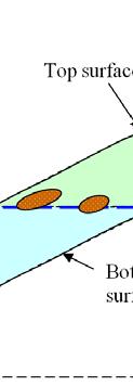
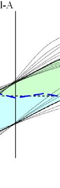
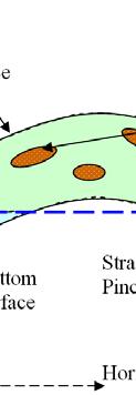


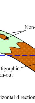


8 Table-4: HIIP analysis for Both Layers; values are in million cubic meters. Figure 1: Reservoir Cross-section: The reservoir is bounded by the top and bottom structure surfaces and above the OWC level as shown in the green area above and excluding the non-pay facies. Figure 2: The uncertainty of the values of top/bottom surface structure and reservoir thickness increases as goes far from well locations
9 Input data to obtain HIIP (seismic data, porosity, saturations) Top/Bottom Surface, Layer Thickness, and Fluids Contact Surfaces Porosity, Net-to-Gross ratio and Fluid Saturations 1. Generating spatial correlation of uncertainty in the surfaces with a zero mean of parameter uncertainty 1. Cosimulating different realizations for all parameters with seismic data 2. Adding uncertainty in the base case to the base case to get a new realization with new GRV 2. Parameter Uncertainty: Generating parameters histograms by using BS, SBS, or CFD 3. Parameter Uncertainty: Generating parameters histograms by using BS, SBS, or CFD 3. Parameter Uncertainty: repeat first step with changing the mean of parameter uncertainty 4. Parameter Uncertainty: repeat first two steps with a variable mean of parameter uncertainty obtained from step 3 histograms Combine all realizations obtained for different parameters to get HIIP in a distribution with/without parameter uncertainty Figure 3: Flowchart of the proposed methodology


10 Figure 4: 3D view of Hekla field, top structure of H1 layer. Figure-5: Contour map of H1 layer depth in Hekla field with showing the distribution of twenty well locations
11 Figure 6: The variogram models fitting the experimental variograms for H1 Top Structure Depth. Figure 7: Case1-Histograms of HIIP for Both Layers above OWC of 2150m with uncertainty in Top/Bottom Surface Structure with a mean of zero and a standardd deviation of 15m. Figure 8: Case4-CDF s of HIIP for Both Layers above OWC of 2150m with uncertainty in OWC depth level with a mean of zero and a standard deviation of 1m, 2m, 4m, and 8m, respectively


12 Figure 9: The histogram of porosity data obtained from logs over 10% porosity cutoff. Figure 10: Case9-Histogramss of HIIP for H1 Layer above OWC of 2150m with Full Uncertainty. Figure 11: Tornado Chart for HIIP Distributions of H1 Layer
Best Practice Reservoir Characterization for the Alberta Oil Sands
 Best Practice Reservoir Characterization for the Alberta Oil Sands Jason A. McLennan and Clayton V. Deutsch Centre for Computational Geostatistics (CCG) Department of Civil and Environmental Engineering
We LHR3 04 Realistic Uncertainty Quantification in Geostatistical Seismic Reservoir Characterization
 We LHR3 04 Realistic Uncertainty Quantification in Geostatistical Seismic Reservoir Characterization A. Moradi Tehrani* (CGG), A. Stallone (Roma Tre University), R. Bornard (CGG) & S. Boudon (CGG) SUMMARY
A MultiGaussian Approach to Assess Block Grade Uncertainty
 A MultiGaussian Approach to Assess Block Grade Uncertainty Julián M. Ortiz 1, Oy Leuangthong 2, and Clayton V. Deutsch 2 1 Department of Mining Engineering, University of Chile 2 Department of Civil &
Large Scale Modeling by Bayesian Updating Techniques
 Large Scale Modeling by Bayesian Updating Techniques Weishan Ren Centre for Computational Geostatistics Department of Civil and Environmental Engineering University of Alberta Large scale models are useful
Geostatistical Determination of Production Uncertainty: Application to Firebag Project
 Geostatistical Determination of Production Uncertainty: Application to Firebag Project Abstract C. V. Deutsch, University of Alberta (cdeutsch@civil.ualberta.ca) E. Dembicki and K.C. Yeung, Suncor Energy
Constraining Uncertainty in Static Reservoir Modeling: A Case Study from Namorado Field, Brazil*
 Constraining Uncertainty in Static Reservoir Modeling: A Case Study from Namorado Field, Brazil* Juliana F. Bueno 1, Rodrigo D. Drummond 1, Alexandre C. Vidal 1, Emilson P. Leite 1, and Sérgio S. Sancevero
Geostatistics for Seismic Data Integration in Earth Models
 2003 Distinguished Instructor Short Course Distinguished Instructor Series, No. 6 sponsored by the Society of Exploration Geophysicists European Association of Geoscientists & Engineers SUB Gottingen 7
Statistical Rock Physics
 Statistical - Introduction Book review 3.1-3.3 Min Sun March. 13, 2009 Outline. What is Statistical. Why we need Statistical. How Statistical works Statistical Rock physics Information theory Statistics
Acceptable Ergodic Fluctuations and Simulation of Skewed Distributions
 Acceptable Ergodic Fluctuations and Simulation of Skewed Distributions Oy Leuangthong, Jason McLennan and Clayton V. Deutsch Centre for Computational Geostatistics Department of Civil & Environmental Engineering
Multiple-Point Geostatistics: from Theory to Practice Sebastien Strebelle 1
 Multiple-Point Geostatistics: from Theory to Practice Sebastien Strebelle 1 Abstract The limitations of variogram-based simulation programs to model complex, yet fairly common, geological elements, e.g.
An Overview of the Tapia Canyon Field Static Geocellular Model and Simulation Study
 An Overview of the Tapia Canyon Field Static Geocellular Model and Simulation Study Prepared for Sefton Resources Inc. Jennifer Dunn, Chief Geologist Petrel Robertson Consulting Ltd. Outline Background
Advances in Locally Varying Anisotropy With MDS
 Paper 102, CCG Annual Report 11, 2009 ( 2009) Advances in Locally Varying Anisotropy With MDS J.B. Boisvert and C. V. Deutsch Often, geology displays non-linear features such as veins, channels or folds/faults
Characterization of Geoobjects Continuity using Moments of Inertia
 Characterization of Geoobjects Continuity using Moments of Inertia Saina Lajevardi, Olena Babak, and Clayton V. Deutsch Well-placement is one of the main challenges in reservoir engineering. The connectivity
Reliability of Seismic Data for Hydrocarbon Reservoir Characterization
 Reliability of Seismic Data for Hydrocarbon Reservoir Characterization Geetartha Dutta (gdutta@stanford.edu) December 10, 2015 Abstract Seismic data helps in better characterization of hydrocarbon reservoirs.
Net-to-gross from Seismic P and S Impedances: Estimation and Uncertainty Analysis using Bayesian Statistics
 Net-to-gross from Seismic P and S Impedances: Estimation and Uncertainty Analysis using Bayesian Statistics Summary Madhumita Sengupta*, Ran Bachrach, Niranjan Banik, esterngeco. Net-to-gross (N/G ) is
Entropy of Gaussian Random Functions and Consequences in Geostatistics
 Entropy of Gaussian Random Functions and Consequences in Geostatistics Paula Larrondo (larrondo@ualberta.ca) Department of Civil & Environmental Engineering University of Alberta Abstract Sequential Gaussian
Automatic Determination of Uncertainty versus Data Density
 Automatic Determination of Uncertainty versus Data Density Brandon Wilde and Clayton V. Deutsch It is useful to know how various measures of uncertainty respond to changes in data density. Calculating
Uncertainty estimation in volumetrics for supporting hydrocarbon E&P decision making
 Uncertainty estimation in volumetrics for supporting hydrocarbon E&P decision making Frans J.T. Floris 1 and Martin R.H.E. Peersmann Netherlands Institute of Applied Geoscience TNO P.O. Box 6012, 2600
Combining geological surface data and geostatistical model for Enhanced Subsurface geological model
 Combining geological surface data and geostatistical model for Enhanced Subsurface geological model M. Kurniawan Alfadli, Nanda Natasia, Iyan Haryanto Faculty of Geological Engineering Jalan Raya Bandung
3D Geological Modeling and Uncertainty Analysis of Pilot Pad in the Long Lake Field with Lean Zone and Shale Layer
 Datapages/Search and Discovery Article #9224 GeoConvention 214, FOCUS - Adapt, Refine, Sustain Calgary, Alberta, Canada, May 12-16, 214 3D Geological Modeling and Uncertainty Analysis of Pilot Pad in the
Reservoir Modeling with GSLIB. Overview
 Reservoir Modeling with GSLIB Overview Objectives of the Course What is Geostatistics? Why Geostatistics / 3-D Modeling? Uncertainty Quantification and Decision Making Heterogeneous Reservoir Modeling
Training Venue and Dates Ref # Reservoir Geophysics October, 2019 $ 6,500 London
 Training Title RESERVOIR GEOPHYSICS Training Duration 5 days Training Venue and Dates Ref # Reservoir Geophysics DE035 5 07 11 October, 2019 $ 6,500 London In any of the 5 star hotels. The exact venue
4th HR-HU and 15th HU geomathematical congress Geomathematics as Geoscience Reliability enhancement of groundwater estimations
 Reliability enhancement of groundwater estimations Zoltán Zsolt Fehér 1,2, János Rakonczai 1, 1 Institute of Geoscience, University of Szeged, H-6722 Szeged, Hungary, 2 e-mail: zzfeher@geo.u-szeged.hu
Caracterização de. Michelle Uchôa Chaves Geóloga SIS Brasil
 Caracterização de Reservatórios Michelle Uchôa Chaves Geóloga SIS Brasil Email: mchaves@slb.com Introduction into SIS Schlumberger Information Solutions (SIS), an operating unit of Schlumberger, is organized
NEW GEOLOGIC GRIDS FOR ROBUST GEOSTATISTICAL MODELING OF HYDROCARBON RESERVOIRS
 FOR ROBUST GEOSTATISTICAL MODELING OF HYDROCARBON RESERVOIRS EMMANUEL GRINGARTEN, BURC ARPAT, STANISLAS JAYR and JEAN- LAURENT MALLET Paradigm Houston, USA. ABSTRACT Geostatistical modeling of reservoir
A Short Note on the Proportional Effect and Direct Sequential Simulation
 A Short Note on the Proportional Effect and Direct Sequential Simulation Abstract B. Oz (boz@ualberta.ca) and C. V. Deutsch (cdeutsch@ualberta.ca) University of Alberta, Edmonton, Alberta, CANADA Direct
Opportunities in Oil and Gas Fields Questions TABLE OF CONTENTS
 TABLE OF CONTENTS A. Asset... 3 1. What is the size of the opportunity (size the prize)?... 3 2. Volumetric Evaluation... 3 3. Probabilistic Volume Estimates... 3 4. Material Balance Application... 3 5.
5 ORIGINAL HYDROCARBONS IN PLACE
 5 ORIGINAL HYDROCARBONS IN PLACE The deterministic estimation of oil in place for the White Rose Field was completed using 3-D geological modelling in the RMS software package. This procedure involves
Facies Modeling in Presence of High Resolution Surface-based Reservoir Models
 Facies Modeling in Presence of High Resolution Surface-based Reservoir Models Kevin Zhang Centre for Computational Geostatistics Department of Civil and Environmental Engineering University of Alberta
Geostatistical History Matching coupled with Adaptive Stochastic Sampling: A zonation-based approach using Direct Sequential Simulation
 Geostatistical History Matching coupled with Adaptive Stochastic Sampling: A zonation-based approach using Direct Sequential Simulation Eduardo Barrela* Instituto Superior Técnico, Av. Rovisco Pais 1,
Downloaded 09/15/16 to Redistribution subject to SEG license or copyright; see Terms of Use at
 A Full Field Static Model of the RG-oil Field, Central Sirte Basin, Libya Abdalla Abdelnabi*, Kelly H. Liu, and Stephen Gao Missouri University of Science and Technology Summary Cambrian-Ordovician and
Geostatistical History Matching coupled with Adaptive Stochastic Sampling
 Geostatistical History Matching coupled with Adaptive Stochastic Sampling A Geologically consistent approach using Stochastic Sequential Simulation Eduardo Barrela Nº 79909 Project Thesis Presentation
Geostatistical Determination of Production Uncertainty: Application to Pogo Gold Project
 Geostatistical Determination of Production Uncertainty: Application to Pogo Gold Project Jason A. McLennan 1, Clayton V. Deutsch 1, Jack DiMarchi 2 and Peter Rolley 2 1 University of Alberta 2 Teck Cominco
Fred Mayer 1; Graham Cain 1; Carmen Dumitrescu 2; (1) Devon Canada; (2) Terra-IQ Ltd. Summary
 Devon Canada; (2) Terra-IQ Ltd. Summary") 2401377 Statistically Improved Resistivity and Density Estimation From Multicomponent Seismic Data: Case Study from the Lower Cretaceous McMurray Formation, Athabasca Oil Sands Fred Mayer 1; Graham Cain
2401377 Statistically Improved Resistivity and Density Estimation From Multicomponent Seismic Data: Case Study from the Lower Cretaceous McMurray Formation, Athabasca Oil Sands Fred Mayer 1; Graham Cain
GSLIB Geostatistical Software Library and User's Guide
 GSLIB Geostatistical Software Library and User's Guide Second Edition Clayton V. Deutsch Department of Petroleum Engineering Stanford University Andre G. Journel Department of Geological and Environmental
Building an Integrated Static Reservoir Model 5-day Course
 Building an Integrated Static Reservoir Model 5-day Course Prepared by International Reservoir Technologies Lakewood, Colorado http://www.irt-inc.com/ 1 Agenda Day 1 Day 2 Day 3 Day 4 Day 5 Morning Introduction
Probability Distribution
 Economic Risk and Decision Analysis for Oil and Gas Industry CE81.98 School of Engineering and Technology Asian Institute of Technology January Semester Presented by Dr. Thitisak Boonpramote Department
Risk Factors in Reservoir Simulation
 Risk Factors in Reservoir Simulation Dr. Helmy Sayyouh Petroleum Engineering Cairo University 12/26/2017 1 Sources Of Data Petro-physical Data Water saturation may be estimated from log analysis, capillary
Latin Hypercube Sampling with Multidimensional Uniformity
 Latin Hypercube Sampling with Multidimensional Uniformity Jared L. Deutsch and Clayton V. Deutsch Complex geostatistical models can only be realized a limited number of times due to large computational
Building Blocks for Direct Sequential Simulation on Unstructured Grids
 Building Blocks for Direct Sequential Simulation on Unstructured Grids Abstract M. J. Pyrcz (mpyrcz@ualberta.ca) and C. V. Deutsch (cdeutsch@ualberta.ca) University of Alberta, Edmonton, Alberta, CANADA
Porosity prediction using cokriging with multiple secondary datasets
 Cokriging with Multiple Attributes Porosity prediction using cokriging with multiple secondary datasets Hong Xu, Jian Sun, Brian Russell, Kris Innanen ABSTRACT The prediction of porosity is essential for
Formats for Expressing Acceptable Uncertainty
 Formats for Expressing Acceptable Uncertainty Brandon J. Wilde and Clayton V. Deutsch This short note aims to define a number of formats that could be used to express acceptable uncertainty. These formats
Tim Carr - West Virginia University
 Tim Carr - West Virginia University Role of Geology in Field Development Develop static geological model of the reservoir(s) Analyze relevant geoscience and engineering data, integrate them into model
Main Challenges and Uncertainties for Oil Production from Turbidite Reservoirs in Deep Water Campos Basin, Brazil*
 Main Challenges and Uncertainties for Oil Production from Turbidite Reservoirs in Deep Water Campos Basin, Brazil* Carlos H. Bruhn 1, Antonio Pinto 1, and Paulo R. Johann 1 Search and Discovery Article
Computational Challenges in Reservoir Modeling. Sanjay Srinivasan The Pennsylvania State University
 Computational Challenges in Reservoir Modeling Sanjay Srinivasan The Pennsylvania State University Well Data 3D view of well paths Inspired by an offshore development 4 platforms 2 vertical wells 2 deviated
Quantitative Seismic Interpretation An Earth Modeling Perspective
 Quantitative Seismic Interpretation An Earth Modeling Perspective Damien Thenin*, RPS, Calgary, AB, Canada TheninD@rpsgroup.com Ron Larson, RPS, Calgary, AB, Canada LarsonR@rpsgroup.com Summary Earth models
CO 2 storage capacity and injectivity analysis through the integrated reservoir modelling
 CO 2 storage capacity and injectivity analysis through the integrated reservoir modelling Dr. Liuqi Wang Geoscience Australia CO 2 Geological Storage and Technology Training School of CAGS Beijing, P.
IJMGE Int. J. Min. & Geo-Eng. Vol.49, No.1, June 2015, pp
 IJMGE Int. J. Min. & Geo-Eng. Vol.49, No.1, June 2015, pp.131-142 Joint Bayesian Stochastic Inversion of Well Logs and Seismic Data for Volumetric Uncertainty Analysis Moslem Moradi 1, Omid Asghari 1,
Time to Depth Conversion and Uncertainty Characterization for SAGD Base of Pay in the McMurray Formation, Alberta, Canada*
 Time to Depth Conversion and Uncertainty Characterization for SAGD Base of Pay in the McMurray Formation, Alberta, Canada* Amir H. Hosseini 1, Hong Feng 1, Abu Yousuf 1, and Tony Kay 1 Search and Discovery
Multiple realizations using standard inversion techniques a
 Multiple realizations using standard inversion techniques a a Published in SEP report, 105, 67-78, (2000) Robert G Clapp 1 INTRODUCTION When solving a missing data problem, geophysicists and geostatisticians
Reservoir characterization
 1/15 Reservoir characterization This paper gives an overview of the activities in geostatistics for the Petroleum industry in the domain of reservoir characterization. This description has been simplified
The SPE Foundation through member donations and a contribution from Offshore Europe
 Primary funding is provided by The SPE Foundation through member donations and a contribution from Offshore Europe The Society is grateful to those companies that allow their professionals to serve as
Assessing uncertainty on Net-to-gross at the Appraisal Stage: Application to a West Africa Deep-Water Reservoir
 Assessing uncertainty on Net-to-gross at the Appraisal Stage: Application to a West Africa Deep-Water Reservoir Amisha Maharaja April 25, 2006 Abstract A large data set is available from a deep-water reservoir
Downloaded 10/25/16 to Redistribution subject to SEG license or copyright; see Terms of Use at
 Facies modeling in unconventional reservoirs using seismic derived facies probabilities Reinaldo J. Michelena*, Omar G. Angola, and Kevin S. Godbey, ireservoir.com, Inc. Summary We present in this paper
Reservoir connectivity uncertainty from stochastic seismic inversion Rémi Moyen* and Philippe M. Doyen (CGGVeritas)
") Rémi Moyen* and Philippe M. Doyen (CGGVeritas) Summary Static reservoir connectivity analysis is sometimes based on 3D facies or geobody models defined by combining well data and inverted seismic impedances.
Rémi Moyen* and Philippe M. Doyen (CGGVeritas) Summary Static reservoir connectivity analysis is sometimes based on 3D facies or geobody models defined by combining well data and inverted seismic impedances.
Determination of Locally Varying Directions through Mass Moment of Inertia Tensor
 Determination of Locally Varying Directions through Mass Moment of Inertia Tensor R. M. Hassanpour and C.V. Deutsch Centre for Computational Geostatistics Department of Civil and Environmental Engineering
Traps for the Unwary Subsurface Geoscientist
 Traps for the Unwary Subsurface Geoscientist ashley.francis@sorviodvnvm.co.uk http://www.sorviodvnvm.co.uk Presented at SEG Development & Production Forum, 24-29 th June 2001, Taos, New Mexico, USA 24-29
Grain Size Geostatistics Enhance Reservoir Characterisation
 Grain Size Geostatistics Enhance Reservoir Characterisation Robert Duller (University of Liverpool) Ricki Walker (Conwy Valley Systems Ltd.) Barrie Wells (Conwy Valley Systems Ltd.) Advances in modelling
Conditional Distribution Fitting of High Dimensional Stationary Data
 Conditional Distribution Fitting of High Dimensional Stationary Data Miguel Cuba and Oy Leuangthong The second order stationary assumption implies the spatial variability defined by the variogram is constant
Stanford Exploration Project, Report 105, September 5, 2000, pages 41 53
 Stanford Exploration Project, Report 105, September 5, 2000, pages 41 53 40 Stanford Exploration Project, Report 105, September 5, 2000, pages 41 53 Short Note Multiple realizations using standard inversion
Hydrocarbon Potential of the Marginal Fields in Niger Delta Oza Field, a case study*
 Hydrocarbon Potential of the Marginal Fields in Niger Delta Oza Field, a case study* J.N. Sahu 1, C.H.V. Satya Sai 1, V. Chintamani 1 and C. Vishnu Vardhan 1 Search and Discovery Article #20182 (2012)*
Optimizing Thresholds in Truncated Pluri-Gaussian Simulation
 Optimizing Thresholds in Truncated Pluri-Gaussian Simulation Samaneh Sadeghi and Jeff B. Boisvert Truncated pluri-gaussian simulation (TPGS) is an extension of truncated Gaussian simulation. This method
Advanced analysis and modelling tools for spatial environmental data. Case study: indoor radon data in Switzerland
 EnviroInfo 2004 (Geneva) Sh@ring EnviroInfo 2004 Advanced analysis and modelling tools for spatial environmental data. Case study: indoor radon data in Switzerland Mikhail Kanevski 1, Michel Maignan 1
PETROPHYSICAL EVALUATION CORE COPYRIGHT. Petrophysical Evaluation Approach and Shaly Sands Evaluation. By the end of this lesson, you will be able to:
 PETROPHYSICAL EVALUATION CORE Petrophysical Evaluation Approach and Shaly Sands Evaluation LEARNING OBJECTIVES By the end of this lesson, you will be able to: Discuss how to approach a petrophysical evaluation
23855 Rock Physics Constraints on Seismic Inversion
 23855 Rock Physics Constraints on Seismic Inversion M. Sams* (Ikon Science Ltd) & D. Saussus (Ikon Science) SUMMARY Seismic data are bandlimited, offset limited and noisy. Consequently interpretation of
CHAPTER III. METHODOLOGY
 CHAPTER III. METHODOLOGY III.1. REASONING METHODOLOGY Analytical reasoning method which used in this study are: Deductive accumulative method: Reservoir connectivity can be evaluated from geological, geophysical
Sequential Simulations of Mixed Discrete-Continuous Properties: Sequential Gaussian Mixture Simulation
 Sequential Simulations of Mixed Discrete-Continuous Properties: Sequential Gaussian Mixture Simulation Dario Grana, Tapan Mukerji, Laura Dovera, and Ernesto Della Rossa Abstract We present here a method
Evaluation of Mineral Resource risk at a high grade underground gold mine
 Evaluation of Mineral Resource risk at a high grade underground gold mine Presented by: Aaron Meakin Manager Corporate Services CSA Global 21 August 2015 Project Background Beaconsfield Gold Mine, Tasmania
PETROLEUM RESERVOIR CHARACTERIZATION
 PETROLEUM RESERVOIR CHARACTERIZATION Eliandro Admir da Rocha Marques ABSTRACT The reservoir simulation in the oil industry has become the standard for the solution of engineering problems of reservoirs.
Subsurface Consultancy Services
 Subsurface Consultancy Services Porosity from Reservoir Modeling Perspective Arnout Everts with contributions by Peter Friedinger and Laurent Alessio FESM June 2011 LEAP Energy Main Office: G-Tower, level
A STATIC 3D MODELING OF HYDROCARBONIC RESERVOIR WITH THE HELP OF RMS CASE study: THE SOUTH EAST ANTICLINE OF KHUZESTAN IRAN
 :43-48 www.amiemt.megig.ir A STATIC 3D MODELING OF HYDROCARBONIC RESERVOIR WITH THE HELP OF RMS CASE study: THE SOUTH EAST ANTICLINE OF KHUZESTAN IRAN Hamid reza samadi 1,mohammad hadi Salehi 2 1 PH.D
Correcting Variogram Reproduction of P-Field Simulation
 Correcting Variogram Reproduction of P-Field Simulation Julián M. Ortiz (jmo1@ualberta.ca) Department of Civil & Environmental Engineering University of Alberta Abstract Probability field simulation is
Petrophysical Data Acquisition Basics. Coring Operations Basics
 Petrophysical Data Acquisition Basics Coring Operations Basics Learning Objectives By the end of this lesson, you will be able to: Understand why cores are justified and who needs core data Identify which
Reservoir Forecast Optimism Impact of Geostatistics, Reservoir Modeling, Heterogeneity, and Uncertainty
 Reservoir Forecast Optimism Impact of Geostatistics, Reservoir Modeling, Heterogeneity, and Uncertainty W. Scott Meddaugh, W. Terry Osterloh, and Nicole Champenoy Chevron, Houston scottmeddaugh@chevron.com
Manuscript of paper for APCOM 2003.
 1 Manuscript of paper for APCOM 2003. AN ANALYSIS OF THE PRACTICAL AND ECONOMIC IMPLICATIONS OF SYSTEMATIC UNDERGROUND DRILLING IN DEEP SOUTH AFRICAN GOLD MINES W. ASSIBEY-BONSU Consultant: Geostatistics
A013 HISTORY MATCHING WITH RESPECT TO RESERVOIR STRUCTURE
 A3 HISTORY MATCHING WITH RESPECT TO RESERVOIR STRUCTURE SIGURD IVAR AANONSEN ; ODDVAR LIA ; AND OLE JAKOB ARNTZEN Centre for Integrated Research, University of Bergen, Allégt. 4, N-7 Bergen, Norway Statoil
*Oil and Natural Gas Corporation Limited, 4th Floor GEOPIC, Dehradun , Uttarakhand # Roxar, Emerson Process Management
 Generation of regional trend from Boolean log of lithofacies for building a realistic fine scale geological model using stochastic facies modelling A case study BS Bisht, Ajeet Pandey*, SP Singh, Samir
A Case for Geometric Criteria in Resources and Reserves Classification
 A Case for Geometric Criteria in Resources and Reserves Classification Clayton V. Deutsch 1, Oy Leuangthong 1 and Julián Ortiz C. 2 1 Centre for Computational Geostatistics (CCG) University of Alberta
A NEW APPROACH FOR QUANTIFYING THE IMPACT OF GEOSTATISTICAL UNCERTAINTY ON PRODUCTION FORECASTS: THE JOINT MODELING METHOD
 A NEW APPROACH FOR QUANTIFYING THE IMPACT OF GEOSTATISTICAL UNCERTAINTY ON PRODUCTION FORECASTS: THE JOINT MODELING METHOD IAMG, Cancun, September 6-1, 001 Isabelle Zabalza-Mezghani, IFP Emmanuel Manceau,
Subsurface Mapping 1 TYPES OF SUBSURFACE MAPS:- 1.1 Structural Maps and Sections: -
 Subsurface Mapping The purpose of subsurface mapping in the geology of petroleum Is to find traps that contain oil and gas pools and the information obtained from wells forms the heart of the data upon
A008 THE PROBABILITY PERTURBATION METHOD AN ALTERNATIVE TO A TRADITIONAL BAYESIAN APPROACH FOR SOLVING INVERSE PROBLEMS
 A008 THE PROAILITY PERTURATION METHOD AN ALTERNATIVE TO A TRADITIONAL AYESIAN APPROAH FOR SOLVING INVERSE PROLEMS Jef AERS Stanford University, Petroleum Engineering, Stanford A 94305-2220 USA Abstract
Optimizing the reservoir model of delta front sandstone using Seismic to Simulation workflow: A case study in the South China Sea
 Optimizing the reservoir model of delta front sandstone using Seismic to Simulation workflow: Lin Li and Bin Tao, CNOOC (China) Panyu Operating Company; Haihong Wang*, Shulin Sun, Fengping Mu, Wanlong
Quantitative Interpretation
 Quantitative Interpretation The aim of quantitative interpretation (QI) is, through the use of amplitude analysis, to predict lithology and fluid content away from the well bore. This process should make
Contents 1 Introduction 2 Statistical Tools and Concepts
 1 Introduction... 1 1.1 Objectives and Approach... 1 1.2 Scope of Resource Modeling... 2 1.3 Critical Aspects... 2 1.3.1 Data Assembly and Data Quality... 2 1.3.2 Geologic Model and Definition of Estimation
Relinquishment Report for Licence Number P1356, Block 48/8c March 2008
 Relinquishment Report for Licence Number P1356, Block 48/8c March 2008 Table of Contents 1.0 Header...3 2.0 Synopsis...3 3.0 Exploration Activities...4 4.0 Prospectivity Analysis...11 5.0 Conclusions...12
Recent developments in object modelling opens new era for characterization of fluvial reservoirs
 Recent developments in object modelling opens new era for characterization of fluvial reservoirs Markus L. Vevle 1*, Arne Skorstad 1 and Julie Vonnet 1 present and discuss different techniques applied
COLLOCATED CO-SIMULATION USING PROBABILITY AGGREGATION
 COLLOCATED CO-SIMULATION USING PROBABILITY AGGREGATION G. MARIETHOZ, PH. RENARD, R. FROIDEVAUX 2. CHYN, University of Neuchâtel, rue Emile Argand, CH - 2009 Neuchâtel, Switzerland 2 FSS Consultants, 9,
Identified a possible new offset location where the customer is currently exploring drill options.
 GroundMetrics was hired to conduct a Full-Field Resistivity Survey for an oil and gas producer that needed to make crucial decisions to drive profitability at the location. The results saved them hundreds
QUANTITATIVE INTERPRETATION
 QUANTITATIVE INTERPRETATION THE AIM OF QUANTITATIVE INTERPRETATION (QI) IS, THROUGH THE USE OF AMPLITUDE ANALYSIS, TO PREDICT LITHOLOGY AND FLUID CONTENT AWAY FROM THE WELL BORE This process should make
Assessing the Value of Information from Inverse Modelling for Optimising Long-Term Oil Reservoir Performance
 Assessing the Value of Information from Inverse Modelling for Optimising Long-Term Oil Reservoir Performance Eduardo Barros, TU Delft Paul Van den Hof, TU Eindhoven Jan Dirk Jansen, TU Delft 1 Oil & gas
Geostatistical applications in petroleum reservoir modelling
 Geostatistical applications in petroleum reservoir modelling by R. Cao*, Y. Zee Ma and E. Gomez Synopsis Geostatistics was initially developed in the mining sector, but has been extended to other geoscience
3D Time-lapse Seismic Modeling for CO2 Sequestration
 3D Time-lapse Seismic Modeling for CO2 Sequestration Jintan Li Advisor: Dr. Christopher Liner April 29 th, 2011 1 Outline Background/Introduction Methods Preliminary Results Future Work 2 Goal Flow simulation
Stepwise Conditional Transformation for Simulation of Multiple Variables 1
 Mathematical Geology, Vol. 35, No. 2, February 2003 ( C 2003) Stepwise Conditional Transformation for Simulation of Multiple Variables 1 Oy Leuangthong 2 and Clayton V. Deutsch 2 Most geostatistical studies
The Snap lake diamond deposit - mineable resource.
 Title Page: Author: Designation: Affiliation: Address: Tel: Email: The Snap lake diamond deposit - mineable resource. Fanie Nel Senior Mineral Resource Analyst De Beers Consolidated Mines Mineral Resource
COLLOCATED CO-SIMULATION USING PROBABILITY AGGREGATION
 COLLOCATED CO-SIMULATION USING PROBABILITY AGGREGATION G. MARIETHOZ, PH. RENARD, R. FROIDEVAUX 2. CHYN, University of Neuchâtel, rue Emile Argand, CH - 2009 Neuchâtel, Switzerland 2 FSS Consultants, 9,
PRODUCING PROBABILITY MAPS TO ASSESS RISK OF EXCEEDING CRITICAL THRESHOLD VALUE OF SOIL EC USING GEOSTATISTICAL APPROACH
 PRODUCING PROBABILITY MAPS TO ASSESS RISK OF EXCEEDING CRITICAL THRESHOLD VALUE OF SOIL EC USING GEOSTATISTICAL APPROACH SURESH TRIPATHI Geostatistical Society of India Assumptions and Geostatistical Variogram
Lithology prediction and fluid discrimination in Block A6 offshore Myanmar
 10 th Biennial International Conference & Exposition P 141 Lithology prediction and fluid discrimination in Block A6 offshore Myanmar Hanumantha Rao. Y *, Loic Michel, Hampson-Russell, Kyaw Myint, Ko Ko,
PETROLEUM GEOSCIENCES GEOLOGY OR GEOPHYSICS MAJOR
 PETROLEUM GEOSCIENCES GEOLOGY OR GEOPHYSICS MAJOR APPLIED GRADUATE STUDIES Geology Geophysics GEO1 Introduction to the petroleum geosciences GEO2 Seismic methods GEO3 Multi-scale geological analysis GEO4
Relinquishment Report
 Relinquishment Report Licence P1403 Block 13/22d Chevron North Sea Limited Korean National Oil Company Chevron North Sea Limited December 2009 1 SYNOPSIS... 3 2 INTRODUCTION. 3 2.1 Licence Terms.. 3 2.2
Quantifying uncertainty of geological 3D layer models, constructed with a-priori
 Quantifying uncertainty of geological 3D layer models, constructed with a-priori geological expertise Jan Gunnink, Denise Maljers 2 and Jan Hummelman 2, TNO Built Environment and Geosciences Geological