Gulf Stream Note # The Gulf Stream in the Vicinity of the Rhumb Line Newport to Bermuda June 6, 2017 An Analysis of Conditions
|
|
|
- Ralf Hubbard
- 5 years ago
- Views:
Transcription
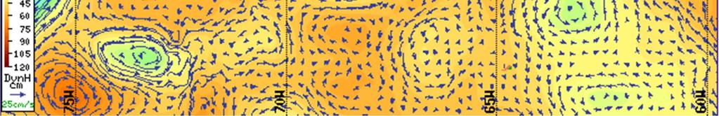
1 Gulf Stream Note # The Gulf Stream in the Vicinity of the Rhumb Line Newport to Bermuda June 6, 2017 An Analysis of Conditions W. Frank Bohlen Mystic, Connecticut Persistent cloud cover continues to limit satellite views of the Gulf Stream region forcing reliance on models and experience gained by previous study. Since the 19 th of May there have been only three days of reasonable visibility allowing some assessment of Stream location, structure and evolution. On 21 May the northern margin of the Stream crossed the rhumb line at a point approximately 240nm from Newport (Fig. 1). To the north of the crossing there was a prominent lobe of warm water with sufficient structure (i.e. thermal contrast) to produce first a set to the east and then a counter flow to the west. These flows effectively offset each other and can be neglected for navigational purposes unless encountered in extremely light winds. To the south of the lobe the main body of the Gulf Stream crosses the rhumb line at a near right angle with flows proceeding from the west to the east. Maximun currents approaching 5 knots are typically located approximately 30nm to the south of the northern edge of the Stream. Exact determination of the width of the main body of the Stream and flow characteristics south to Bermuda is limited by cloud cover. A composite image of sea surface temperatures (SSTs) on the 27 of May (Fig.3) again shows the northern margin of the Stream crossing the rhumb line at a point approximately 240nm from Newport. The warm water lobe remains in evidence with some slight easterly displacement and there is some indication of a developing meander in the main body of the Stream to the west of the rhumb line. The width of the main body of the stream is approximately 70nm. Further south the composite shows several areas of sharp organized thermal contrasts sufficient to produce counter clockwise flow around a region centered near 35 o 15 N 67 o 40 W. This appears to be the remnants of the cold core ring discussed in the last Note. The altimetry based model results for the 29 th of May (two day delay for data processing) show this feature clearly (Fig. 3) and suggest that it influences a region extending through the main body of the Stream to its northern margin. With the exception of the small well defined region of the ring flows through the area are expected to be weak and generally less than 1 knot. Visibility improved significantly on the 3 rd and 4 th of June allowing acquisition of both instantaneous and composite SST images (from The instantaneous image of 4 June again shows little change in Stream position relative to the rhumb line and that the width of the main body of the Stream is approximately 70nm. There is however, some evident easterly displacement of the warm water lobe and clear development of a meander to the west of the rhumb line (Fig.4). On the 4 th the Stream still crossed the rhumb line at a near 1
2 right angle with flows proceeding west to east. Continuing evolution of the meander may result in some change of this pattern over the next few days and may affect navigation both to Bermuda and back to the U.S. To the south of the main body of the Steam the instantaneous SST image of 4 June shows a number of organized thermal patterns similar to those shown on the composite of 27 May (compare Figs 3 and 4). The altimetry based model results for this day (Fig.5) indicates that the temperature water column density- gradients associated with these patterns are sufficient to affect an area of more than 180nm from the northern limit of the Stream to south of 35 o N and to produce a relatively coherent counter-clockwise flow throughout this area. Maximum currents in this system should be less than 1 knot confined to a relatively narrow region along the outer edge of the feature. It s likely that this feature will be affected by the developing meander as it affects entrainment. This possibility should be carefully watched over the next few days leading to the start of the Marion Bermuda Race. One last comment. In addition to the large area of counter clockwise flow near the main body of the Stream, the altimetry based model also shows some development of counterclockwise flow to the west of the rhumb line near Bermuda. This feature centered at 32 o 30 N 66 o 45 W is well west of the rhumb line and should drift slowly west. It s another feature that deserves watching. 2

3 Figure 1 Daily Composite Satellite SST Image May 21,

4 Figure 2 Daily Composite Satellite SST Image May 27,

5 Figure 3 Satellite Altimetry Derived Surface Currents NW Atlantic Region May 29,

6 Figure 4 Instantaneous Satellite SST Image June 4,

7 Figure 5 Satellite Altimetry Derived Surface Currents NW Atlantic Region June 6,
The Gulf Stream Near the Rhumb Line Newport-Bermuda June 12, 2018 An Analysis of Conditions
 The Gulf Stream Near the Rhumb Line Newport-Bermuda June 12, 2018 An Analysis of Conditions W. Frank Bohlen (Bohlen@uconn.edu) Mystic, Connecticut Clouds continue to limit satellite views of the Gulf Stream
Gulf Stream. Over the past. Bermuda. water along. rhumb line. appeared. to be clear. appeared. The altimetry allow for
 The Gulf Stream Near the Rhumb Line Newport Bermuda May 31, 2016 An Analysis of Conditions W. Frank Bohlen (Bohlen@uconn.edu) Mystic, Connecticut Over the past two to three weeks the Gulf Stream in the
clockwise be found to
 The Gulf Stream Near the Rhumb Line Newport Bermuda May 8, 2018 An Analysis of Conditions W. Frank Bohlen (Bohlen@uconn.edu) Mystic, Connecticut With little more than one month to go until the start of
Surface Circulation. Key Ideas
 Surface Circulation The westerlies and the trade winds are two of the winds that drive the ocean s surface currents. 1 Key Ideas Ocean water circulates in currents. Surface currents are caused mainly by
Ocean Currents and Climate
 Ocean Currents and Climate Ocean water contains streamlike movements of water called ocean currents. Currents are influenced by a number of factors, including weather, the Earth's rotation, and the position
Science 1206 SAMPLE Test ( Weather Dynamics)
") Science 1206 SAMPLE Test ( Weather Dynamics) Name:. Part A: Multiple Choice (60%) Shade the letter of the best answer on the Scantron sheet provided. 1. Which term refers to the current atmospheric conditions?
Science 1206 SAMPLE Test ( Weather Dynamics) Name:. Part A: Multiple Choice (60%) Shade the letter of the best answer on the Scantron sheet provided. 1. Which term refers to the current atmospheric conditions?
Anticipation Guide #2
 Weather Systems Anticipation Guide #2 Density differences in the atmosphere are responsible for redistributing earth s heat When air is heated it rises, cools and expands releasing energy mt air masses
Upper Ocean Circulation
 Upper Ocean Circulation C. Chen General Physical Oceanography MAR 555 School for Marine Sciences and Technology Umass-Dartmouth 1 MAR555 Lecture 4: The Upper Oceanic Circulation The Oceanic Circulation
I. Ocean Layers and circulation types
 OCEAN Title CIRCULATION slide I. Ocean Layers and circulation types 1) Ocean Layers Ocean is strongly Stratified Consists of distinct LAYERS controlled by density takes huge amounts of energy to mix up
Hurricanes. April 14, 2009
 Tropical Weather & Hurricanes Chapter 15 April 14, 2009 Tropical meteorology Tropics characterized by seasonal wet and drier periods- wet when sun is nearly overhead at noon and inter-tropical convergence
I. Ocean Layers and circulation types
 OCEAN CIRCULATION I. Ocean Layers and circulation types 1) Ocean Layers Ocean is strongly Stratified Consists of distinct LAYERS controlled by density takes huge amounts of energy to mix up the stable
Currents & Gyres Notes
 Currents & Gyres Notes Current A river of water flowing in the ocean. 2 Types of Currents Surface Currents wind-driven currents that occur in the top 100m or less Deep Currents density-driven currents
Global Weather Trade Winds etc.notebook February 17, 2017
 Global Weather 1 north pole northern hemisphere equator southern hemisphere south pole 2 We have seasons because of the Earth's tilt The seasons are opposite in the northern and southern hemispheres winter
AT SEA: INVESTIGATING SOME OCEAN DYNAMICS
 NAME DATE PARTNER(S) AT SEA: INVESTIGATING SOME OCEAN DYNAMICS About three-quarters of the Earth s surface are covered by water in the form of oceans. These giant bodies of water have fascinated and intimidated
Lecture 18 Hurricanes
 Lecture 18 Hurricanes Part I Structure and Climatology What is a hurricane? What is the structure or anatomy of a hurricane? How to build a hurricane - hurricane energy Hurricane climatology - when and
Global Wind Patterns
 Name: Earth Science: Date: Period: Global Wind Patterns 1. Which factor causes global wind patterns? a. changes in the distance between Earth and the Moon b. unequal heating of Earth s surface by the Sun
Hurricanes Part I Structure and Climatology by Professor Steven Businger. Hurricane Katrina
 Hurricanes Part I Structure and Climatology by Professor Steven Businger Hurricane Katrina Hurricanes Part I Structure and Climatology by Professor Steven Businger What is a hurricane? What is the structure
Observation Homework Due 11/24. Previous Lecture. Midlatitude Cyclones
 Lecture 21 Midlatitude Cyclones Observation Homework Due 11/24 1 2 Midlatitude Cyclones Midlatitude Cyclone or Winter Storm Cyclogenesis Energy Source Life Cycle Air Streams Vertical Structure Storm Hazards
Satellites, Weather and Climate Module??: Polar Vortex
 Satellites, Weather and Climate Module??: Polar Vortex SWAC Jan 2014 AKA Circumpolar Vortex Science or Hype? Will there be one this year? Today s objectives Pre and Post exams What is the Polar Vortex
Pilots watch the clouds, because clouds can indicate the kind of weather in store for a flight.
 Low stratus Cumulonimbus Pilots watch the clouds, because clouds can indicate the kind of weather in store for a flight. FILL IN THE BLANKS OR CIRCLE ONE: A. Stratus means flat or on one level. Low stratus
CHAPTER 7 Ocean Circulation Pearson Education, Inc.
 CHAPTER 7 Ocean Circulation 2011 Pearson Education, Inc. Types of Ocean Currents Surface currents Deep currents 2011 Pearson Education, Inc. Measuring Surface Currents Direct methods Floating device tracked
True or false: The atmosphere is always in hydrostatic balance. A. True B. False
 Clicker Questions and Clicker Quizzes Clicker Questions Chapter 7 Of the four forces that affect the motion of air in our atmosphere, which is to thank for opposing the vertical pressure gradient force
SIO 210 Introduction to Physical Oceanography Mid-term examination November 5, 2012; 50 minutes Answer key
 SIO 210 Introduction to Physical Oceanography Mid-term examination November 5, 2012; 50 minutes Answer key Closed book; one sheet of your own notes is allowed. A calculator is allowed. (100 total points.)
Chapter 9: Weather Patterns
 Chapter 9: Weather Patterns Mid Latitude Cyclones: extratropical cyclones, Nor easters Region southern FL to Alaska Lifecycle and associated weather Regional Influence Polar Front Theory: -Norwegian Cyclone
Custom Weather Forecast
 1 of 23 Custom Weather Forecast 2018 Chicago Yacht Club s Race To Mackinac- Cruising Division Disclaimer: The user assumes all risk related to the use of this Custom Weather Forecast. The crew of the participating
Chapter 24 Tropical Cyclones
 Chapter 24 Tropical Cyclones Tropical Weather Systems Tropical disturbance a cluster of thunderstorms about 250 to 600 km in diameter, originating in the tropics or sub-tropics Tropical depression a cluster
General Comment on Lab Reports: v. good + corresponds to a lab report that: has structure (Intro., Method, Results, Discussion, an Abstract would be
 General Comment on Lab Reports: v. good + corresponds to a lab report that: has structure (Intro., Method, Results, Discussion, an Abstract would be a bonus) is well written (take your time to edit) shows
Ocean surface circulation
 Ocean surface circulation Recall from Last Time The three drivers of atmospheric circulation we discussed: Differential heating Pressure gradients Earth s rotation (Coriolis) Last two show up as direct
Page 1. Name:
 Name: 1) As the difference between the dewpoint temperature and the air temperature decreases, the probability of precipitation increases remains the same decreases 2) Which statement best explains why
Climate vs. Weather. Weather: Short term state of the atmosphere. Climate: The average weather conditions in an area over a long period of time
 Weather and Climate Climate vs. Weather Weather: Short term state of the atmosphere. Temperature, humidity, cloud cover, precipitation, winds, visibility, air pressure, air pollution, etc Climate: The
5 Atmospheric Disturbances 7 1.Cyclones- tropical and temperate and associated weather conditions. 2.Anticyclones and associated weather conditions.
 5 Atmospheric Disturbances 7 1.Cyclones- tropical and temperate and associated weather conditions. 2.Anticyclones and associated weather conditions. atmospheric disturbances (weather systems) that are
Weather, Air Masses, Fronts and Global Wind Patterns. Meteorology
 Weather, Air Masses, Fronts and Global Wind Patterns Meteorology Weather is what conditions of the atmosphere are over a short period of time. Climate is how the atmosphere "behaves" over long periods
ERTH 365 Homework #2: Hurricane Harvey. 100 points
 ERTH 365 Homework #2: Hurricane Harvey 100 points Due by 6pm, Tuesday 30 October 2018, ELECTRONIC SUBMISSON BY EMAIL ONLY BY 6PM (send to klevey@sfsu.edu) (acceptable formats: MS Word, Google Doc, plain
Weather Systems. Section
 Section 1 12.2 Objectives Compare and contrast the three major wind systems. Identify four types of fronts. Distinguish between highand low-pressure systems. Review Vocabulary convection: the transfer
The Planetary Circulation System
 12 The Planetary Circulation System Learning Goals After studying this chapter, students should be able to: 1. describe and account for the global patterns of pressure, wind patterns and ocean currents
Name Period 4 th Six Weeks Notes 2013 Weather
 Name Period 4 th Six Weeks Notes 2013 Weather Radiation Convection Currents Winds Jet Streams Energy from the Sun reaches Earth as electromagnetic waves This energy fuels all life on Earth including the
4/29/2011. Mid-latitude cyclones form along a
 Chapter 10: Cyclones: East of the Rocky Mountain Extratropical Cyclones Environment prior to the development of the Cyclone Initial Development of the Extratropical Cyclone Early Weather Along the Fronts
b. The boundary between two different air masses is called a.
 NAME Earth Science Weather WebQuest Part 1. Air Masses 1. Find out what an air mass is. http://okfirst.mesonet.org/train/meteorology/airmasses.html a. What is an air mass? An air mass is b. The boundary
PS : ES Hurricane Tracking Lab
 PS : ES Hurricane Tracking Lab Copyright 1998, 2005 S.Kluge Name KEY Period Companion Websites: http://weather.unisys.com/hurricane/index.html http://www.atwc.org http://stevekluge.com/geoscience/regentses/labs/hurricane1.html
Hurricanes. Hurricanes are large, tropical storm systems that form and develop over the warm waters near the equator.
 Hurricanes Hurricanes are large, tropical storm systems that form and develop over the warm waters near the equator. They are responsible for weather that can devastate entire communities: Heavy rain --
Go With the Flow From High to Low Investigating Isobars
 Go With the Flow From High to Low Investigating Isobars Science 10 Mrs. Purba Air Masses The air over a warm surface can be heated, causing it to rise above more dense air. The result is the formation
Science 1206 Chapter 1 - Inquiring about Weather
 Science 1206 Chapter 1 - Inquiring about Weather 1.1 - The Atmosphere: Energy Transfer and Properties (pp. 10-25) Weather and the Atmosphere weather the physical conditions of the atmosphere at a specific
Air Masses, Fronts, Storm Systems, and the Jet Stream
 Air Masses, Fronts, Storm Systems, and the Jet Stream Air Masses When a large bubble of air remains over a specific area of Earth long enough to take on the temperature and humidity characteristics of
Applications of an ensemble Kalman Filter to regional ocean modeling associated with the western boundary currents variations
 Applications of an ensemble Kalman Filter to regional ocean modeling associated with the western boundary currents variations Miyazawa, Yasumasa (JAMSTEC) Collaboration with Princeton University AICS Data
Air-Sea Coupling in an Eastern Boundary Current Region
 Air-Sea Coupling in an Eastern Boundary Current Region Eric D. Skyllingstad CEOAS, Oregon State University Roger M. Samelson D. B. Chelton, A. Kurapov CEOAS, Oregon State University N. Perlin RSMAS, University
1 What Is Climate? TAKE A LOOK 2. Explain Why do areas near the equator tend to have high temperatures?
 CHAPTER 17 1 What Is Climate? SECTION Climate BEFORE YOU READ After you read this section, you should be able to answer these questions: What is climate? What factors affect climate? How do climates differ
Wind: Global Systems Chapter 10
 Wind: Global Systems Chapter 10 General Circulation of the Atmosphere General circulation of the atmosphere describes average wind patterns and is useful for understanding climate Over the earth, incoming
Unit Three Worksheet Meteorology/Oceanography 2 WS GE U3 2
 Unit Three Worksheet Meteorology/Oceanography 2 WS GE U3 2 Name Period Section 17.3 1. 2. 3. 4. 5. 6. 7. 8. Of the following, which is NOT a factor that controls temperature? (C) latitude (D) longitude
Can buoys predict hurricanes? Objectives Students will be able to: track drifter buoys determine the course of the gulf stream current
 Drifters Can buoys predict hurricanes? Objectives Students will be able to: track drifter buoys determine the course of the gulf stream current Materials computers with Internet access Student Worksheet
The Earth System - Atmosphere III Convection
 The Earth System - Atmosphere III Convection Thunderstorms 1. A thunderstorm is a storm that produces lightning (and therefore thunder) 2. Thunderstorms frequently produce gusty winds, heavy rain, and
Fronts. Direction of Front
 Fronts Direction of Front Direction of Front Warm Front A cold air mass meets and displaces a warm air mass. Because the moving cold air is more dense, it moves under the less-dense warm air, pushing it
Heavy rains and precipitable water anomalies August 2010 By Richard H. Grumm And Jason Krekeler National Weather Service State College, PA 16803
 Heavy rains and precipitable water anomalies 17-19 August 2010 By Richard H. Grumm And Jason Krekeler National Weather Service State College, PA 16803 1. INTRODUCTION Heavy rain fell over the Gulf States,
Mid-Latitude Cyclones and Fronts. Lecture 12 AOS 101
 Mid-Latitude Cyclones and Fronts Lecture 12 AOS 101 Homework 4 COLDEST TEMPS GEOSTROPHIC BALANCE Homework 4 FASTEST WINDS L Consider an air parcel rising through the atmosphere The parcel expands as it
CHAPTER 9 ATMOSPHERE S PLANETARY CIRCULATION MULTIPLE CHOICE QUESTIONS
 CHAPTER 9 ATMOSPHERE S PLANETARY CIRCULATION MULTIPLE CHOICE QUESTIONS 1. Viewed from above in the Northern Hemisphere, surface winds about a subtropical high blow a. clockwise and inward. b. counterclockwise.
THE FEASIBILITY OF EXTRACTING LOWLEVEL WIND BY TRACING LOW LEVEL MOISTURE OBSERVED IN IR IMAGERY OVER CLOUD FREE OCEAN AREA IN THE TROPICS
 THE FEASIBILITY OF EXTRACTING LOWLEVEL WIND BY TRACING LOW LEVEL MOISTURE OBSERVED IN IR IMAGERY OVER CLOUD FREE OCEAN AREA IN THE TROPICS Toshiro Ihoue and Tetsuo Nakazawa Meteorological Research Institute
Northeast U.S. Early Season Preview 2017 FISHING ACTION STARTING TO WARM UP ALREADY WITH LOTS OF FISH EXPECTED IN MAY
 Northeast U.S. Early Season Preview 2017 FISHING ACTION STARTING TO WARM UP ALREADY WITH LOTS OF FISH EXPECTED IN MAY By Matthew A. Upton and Mitchell A. Roffer ROFFS concludes its 2017 spring preview
Western Boundary Currents. Global Distribution of Western Boundary Currents and their importance
 Western Boundary Currents In previous chapters you have learned about the processes that cause the intensification of currents along the western boundaries of the oceans. In this chapter we will examine
C
 C 0.8 0.4 0.2 0.0-0.2-0.6 Fig. 1. SST-wind relation in the North Pacific and Atlantic Oceans. Left panel: COADS SST (color shade), surface wind vectors, and SLP regressed upon the Pacific Decadal Oscillation
Skewed Occurrence Frequency of Water Temperature and Salinity in the Subarctic Regions
 Journal of Oceanography, Vol. 59, pp. 9 to 99, 3 Skewed Occurrence Frequency of Water Temperature and Salinity in the Subarctic Regions SACHIKO OGUMA *, TORU SUZUKI, SYDNEY LEVITUS and YUTAKA NAGATA Marine
3 Severe Weather. Critical Thinking
 CHAPTER 2 3 Severe Weather SECTION Understanding Weather BEFORE YOU READ After you read this section, you should be able to answer these questions: What are some types of severe weather? How can you stay
Middle-Latitude Cyclone
 Middle-Latitude Cyclone What is a mid-latitude cyclone? - The mid-latitude cyclone is a synoptic scale low pressure system that has cyclonic (counter-clockwise in northern hemisphere) flow that is found
ATSC 201 Final Exam Name: Fall 2008 (total points = 100) Student Number: 1. (2 points) The two main conditions needed for downbursts to form are: and
 Student Number: 1. (2 points) The two main conditions needed for downbursts to form are: and") Prof. Stull (open book) Fall 2008 (total points = 100) Student Number: 1. (2 points) The two main conditions needed for downbursts to form are: and 2. (6 pts) For the most-used imager channels on weather
Prof. Stull (open book) Fall 2008 (total points = 100) Student Number: 1. (2 points) The two main conditions needed for downbursts to form are: and 2. (6 pts) For the most-used imager channels on weather
CHAPTER 2 - ATMOSPHERIC CIRCULATION & AIR/SEA INTERACTION
 Chapter 2 - pg. 1 CHAPTER 2 - ATMOSPHERIC CIRCULATION & AIR/SEA INTERACTION The atmosphere is driven by the variations of solar heating with latitude. The heat is transferred to the air by direct absorption
Tropical Waves. John Cangialosi and Lixion Avila National Hurricane Center. WMO Region IV Tropical Cyclone Workshop
 Tropical Waves John Cangialosi and Lixion Avila National Hurricane Center WMO Region IV Tropical Cyclone Workshop Outline Basic definition Schematic diagrams/interactions Operational products/forecasts
Tropical Storms & Hurricanes Part 1. August 1992
 Lecture #16 (April 5, 2010, Monday) Tropical Storms & Hurricanes Part 1 August 1992 Tracks of rain accumulation & clouds from Hurricane Rita September 2005 Tropical Cyclones Around the Globe Why none here?
Contents. Section 1: Climate Factors. Section 2: Climate Types. Section 3: Climate Effects
 Contents Section 1: Climate Factors 1. Weather or Climate?.... 2 2. Elements of Climate.... 4 3. Factors Affecting Climate.... 10 4. Comparing Climates.... 15 5. Quiz 1.... 20 Section 2: Climate Types
DEPARTMENT OF GEOSCIENCES SAN FRANCISCO STATE UNIVERSITY. Metr Fall 2012 Test #1 200 pts. Part I. Surface Chart Interpretation.
 DEPARTMENT OF GEOSCIENCES SAN FRANCISCO STATE UNIVERSITY NAME Metr 356.01 Fall 2012 Test #1 200 pts Part I. Surface Chart Interpretation. Figure 1. Surface Chart for 1500Z 7 September 2007 1 1. Pressure
Chapter 24. Tropical Cyclones. Tropical Cyclone Classification 4/19/17
 Chapter 24 Tropical Cyclones Tropical Cyclones Most destructive storms on the planet Originate over tropical waters, but their paths often take them over land and into midlatitudes Names Hurricane (Atlantic
CASE STUDY OF THE NOVEMBER WINDSTORM IN SOUTH CENTRAL COLORADO
 32 CASE STUDY OF THE 12-13 NOVEMBER WINDSTORM IN SOUTH CENTRAL COLORADO Paul Wolyn * NOAA/NWS Pueblo, CO 1. INTRODUCTION During the evening and early morning of 12-13 November 2011, a damaging downslope
Ocean Dynamics. The Great Wave off Kanagawa Hokusai
 Ocean Dynamics The Great Wave off Kanagawa Hokusai LO: integrate relevant oceanographic processes with factors influencing survival and growth of fish larvae Physics Determining Ocean Dynamics 1. Conservation
General Atmospheric Circulation
 General Atmospheric Circulation Take away Concepts and Ideas Global circulation: The mean meridional (N-S) circulation Trade winds and westerlies The Jet Stream Earth s climate zones Monsoonal climate
HURRICANES. Source:
 HURRICANES Source: http://www.dc.peachnet.edu/~pgore/students/w97/matheson/hpage.htm What is a hurricane? Violent cyclonic storm that develops in the tropical region Wind speeds are > 74 mph Source: http://www.google.com/imgres?hl=en&sa=x&biw=1920&bih=955&tbm=
Ocean Mixing and Climate Change
 Ocean Mixing and Climate Change Factors inducing seawater mixing Different densities Wind stirring Internal waves breaking Tidal Bottom topography Biogenic Mixing (??) In general, any motion favoring turbulent
An upper to mid level circulation (Low) in the NW Caribbean is
 in the NW Caribbean is") WEEKLY WEATHER OUTLOOK BELIZE, CENTRAL AMERICA PERIOD: Monday-Monday, Oct. 1 October 8, 2012 DATE ISSUED: Monday, Oct 1, 2012 6:00 am RFrutos EcoSolutions & Services SYNOPSIS: An upper to mid level circulation
WEEKLY WEATHER OUTLOOK BELIZE, CENTRAL AMERICA PERIOD: Monday-Monday, Oct. 1 October 8, 2012 DATE ISSUED: Monday, Oct 1, 2012 6:00 am RFrutos EcoSolutions & Services SYNOPSIS: An upper to mid level circulation
TROPICAL STORM HARVEY BRIEFING
 TROPICAL STORM HARVEY BRIEFING 10:00 AM CDT Sunday, August 27, 2017 Prepared by: NWS LIX NWSNewOrleans www.weather.gov/neworleans Situation Overview New Information Tropical Storm Winds 40mph Immediate
Storm Summary for Hurricane Jose
 Storm Summary for Hurricane Jose Tuesday, September 19, 2017 at 11 AM EDT (Output from Hurrevac, based on National Hurricane Center Forecast Advisory #57) Jose is currently a Category 1 hurricane on the
Hurricanes and Tropical Weather Systems:
 Hurricanes and Tropical Weather Systems: An influence on weather in parts of the USA Meteorology 411 Iowa State University Week 2 Bill Gallus Classification/Terminology Tropical Disturbance enhanced convection
Chapter 12: Meteorology
 Chapter 12: Meteorology Section 1: The Causes of Weather 1. Compare and contrast weather and climate. 2. Analyze how imbalances in the heating of Earth s surface create weather. 3. Describe how and where
SEVERE WEATHER AND FRONTS TAKE HOME QUIZ
 1. Most of the hurricanes that affect the east coast of the United States originally form over the A) warm waters of the Atlantic Ocean in summer B) warm land of the southeastern United States in summer
Warm Episode over Indian Sub-continent March 2010 By Richard Grumm National Weather Service State College Contributions by Lance Bosart SUNY Albany
 Warm Episode over Indian Sub-continent March 2010 By Richard Grumm National Weather Service State College Contributions by Lance Bosart SUNY Albany 1. INTRODUCTION A massive subtropical ridge formed over
1 What Is Climate? TAKE A LOOK 2. Explain Why do areas near the equator tend to have high temperatures?
 CHAPTER 17 1 What Is Climate? SECTION Climate BEFORE YOU READ After you read this section, you should be able to answer these questions: What is climate? What factors affect climate? How do climates differ
WEATHER. Review Note Cards
 WEATHER Review Note Cards Thermometer Weather instrument that measures air temperature Units include F, C, and K ESRT 13 Sling Psychrometer Weather instrument that measures relative humidity and dewpoint
Lecture 1. Equations of motion - Newton s second law in three dimensions. Pressure gradient + force force
 Lecture 3 Lecture 1 Basic dynamics Equations of motion - Newton s second law in three dimensions Acceleration = Pressure Coriolis + gravity + friction gradient + force force This set of equations is the
Surface Circulation in the North Atlantic & off of Southern California: Two Models
 Surface Circulation in the North Atlantic & off of Southern California: Two Models Objective 1. To become familiar with large scale surface circulation patterns in ocean. 2. To be able to predict current
Chapter 9 External Energy Fuels Weather and Climate
 Natural Disasters Tenth Edition Chapter 9 External Energy Fuels Weather and Climate Copyright The McGraw-Hill Companies, Inc. Permission required for reproduction or display. 9-1 Weather Versus Climate
11/24/09 OCN/ATM/ESS The Pacific Decadal Oscillation. What is the PDO? Causes of PDO Skepticism Other variability associated with PDO
 11/24/09 OCN/ATM/ESS 587.. The Pacific Decadal Oscillation What is the PDO? Causes of PDO Skepticism Other variability associated with PDO The Pacific Decadal Oscillation (PDO). (+) ( ) EOF 1 of SST (+)
CHAPTER 12 TROPICAL WEATHER SYSTEMS MULTIPLE CHOICE QUESTIONS
 CHAPTER 12 TROPICAL WEATHER SYSTEMS MULTIPLE CHOICE QUESTIONS 1. A hurricane differs from an extra-tropical cyclone in that a hurricane a. has no fronts. b. develops within a uniform warm and humid air
5. Which type of front is represented by letter X?
 Name Weather Regents Review ased your answers to questions 1 through 4 on the four weather station models,,,, and D, below. D 82 012 56 999 78 978 32 002 62 75 24 1. List the letters of the four station
PICTURE OF THE MONTH. Satellite Imagery of Sea Surface Temperature Cooling in the Wake of Hurricane Edouard (1996)
") 2716 MONTHLY WEATHER REVIEW VOLUME 125 PICTURE OF THE MONTH Satellite Imagery of Sea Surface Temperature Cooling in the Wake of Hurricane Edouard (1996) FRANK M. MONALDO Applied Physics Laboratory, The
2716 MONTHLY WEATHER REVIEW VOLUME 125 PICTURE OF THE MONTH Satellite Imagery of Sea Surface Temperature Cooling in the Wake of Hurricane Edouard (1996) FRANK M. MONALDO Applied Physics Laboratory, The
Tropical Update. 1 PM EDT Monday, May 21, 2018 Caribbean Disturbance (20%)
") Tropical Update 1 PM EDT Monday, May 21, 2018 Caribbean Disturbance (20%) This update is intended for government and emergency response officials, and is provided for informational and situational awareness
Tropical Update 1 PM EDT Monday, May 21, 2018 Caribbean Disturbance (20%) This update is intended for government and emergency response officials, and is provided for informational and situational awareness
Introduction to Atmospheric Circulation
 Introduction to Atmospheric Circulation Start rotating table Cloud Fraction Dice Results from http://eos.atmos.washington.edu/erbe/ from http://eos.atmos.washington.edu/erbe/ from http://eos.atmos.washington.edu/erbe/
Mid-latitude Cyclones & Air Masses
 Lab 9 Mid-latitude Cyclones & Air Masses This lab will introduce students to the patterns of surface winds around the center of a midlatitude cyclone of low pressure. The types of weather associated with
Space Atmospheric Gases. the two most common gases; found throughout all the layers a form of oxygen found in the stratosphere
 Earth s atmospheric layers Earth s atmosphere is the layer of gases that surrounds the planet and makes conditions on Earth suitable for living things. Layers Earth s atmosphere is divided into several
3. As warm, moist air moves into a region, barometric pressure readings in the region will generally 1. decrease 2. increase 3.
 Teacher: Mr. Prizzi Castle Learning Review 1 1. Which process most directly results in cloud formation? 1. condensation 3. precipitation 2. transpiration 4. radiation 2. An air mass originating over north
Introduction. One way to monitor the status of this energy is though monitoring sea surface
 Sears 1 Understanding Hurricane Intensity Using Sea Surface Height and Temperature Information John Sears (Plymouth State University) Robbie Hood (NASA-MSFC) Frank LaFontaine (Raytheon) Abstract Warmer
Chapter 1 Section 2. Land, Water, and Climate
 Chapter 1 Section 2 Land, Water, and Climate Vocabulary 1. Landforms- natural features of the Earth s land surface 2. Elevation- height above sea level 3. Relief- changes in height 4. Core- most inner
6.2 Meteorology. A meteorologist is a person who uses scientific principles to explain, understand, observe, or forecast Earth s weather.
 Water and Weather 6.2 Meteorology A meteorologist is a person who uses scientific principles to explain, understand, observe, or forecast Earth s weather. 6.2 Water in the Atmosphere Dew point is the temperature
NW Atlantic warming under climate change: new simulations with high-resolution CESM
 NW Atlantic warming under climate change: new simulations with high-resolution CESM Justin Small John Truesdale, Susan Bates, Gary Strand, Jerry Meehl, Don Wuebbles Acknowledging: Mike Alexander, Andrew
WINTER FORECAST NY Metro
 2015-2016 WINTER FORECAST NY Metro Weather @NY_WX DISCLAIMER: Seasonal forecasting is difficult and this is my first attempt at a Winter Forecast. I ve looked at all factors and put them together to create
E.T. - A LOCAL WAY OF LEARNING E-56
 E.T. - A LOCAL WAY OF LEARNING E-56 Title: Author: Jane Ducey Grade Level: 4-6 Eulalie R. Rivera Elementary School- Concepts: Disciplines: 1. The Sun 1.Earth Science 6. Natural Resources Objective: With