Use of Nowcasting tools, developed in SAF for the diagnosis of fogs in the South Plateau of the Iberian Peninsula.
|
|
|
- Peregrine Lawrence
- 5 years ago
- Views:
Transcription

1 Use of Nowcasting tools, developed in SAF for the diagnosis of fogs in the Darío Cano and Ignacio Palacios Meteorological Regional Centre in Madrid and Castilla-La Mancha
2 Objective: To obtain a vision from the SAFNWP products, especially PWBL, of the mechanisms for formation of fog in this region. Method: Daily analyses and diagnoses for the operative regional nowcasting.
3 Topographic characteristics in the area of study. N Tajo Valley Guadiana Valley Southern plateau in the Iberian Peninsula Madrid Plain of La Mancha Almagro Jucar Valley Albacete The Region is opened to the Atlantic Ocean (to the west) all surrounded by mountains like an amphitheatre. Two river basins pass from east to west separated by the Mounts of Toledo, the basin of the Tajo river and that of the Guadiana river. Eastward the Jucar river spills to the Mediterranean. In the map the principal geographical accidents and some airports can be distinguished.

4 Uso Use of de herramientas Nowcasting tools de seguimiento,, developed in desarrolladas SAF for theen diagnosis SAF para of fogs el in the South diagnóstico Plateau de of nieblas the Iberian en la Meseta Peninsula. Sur de la Península Ibérica: Breezes of mountains: Anabatic flow The anabatic is the meso-ß vision of the Thermal Peninsular Low. (Orlanski classification) Madrid Almagro Albacete In clear days, a moderate flow ( ~10 Kts) from the South- West invades the valleys, go up to the mountains. At the botton of the valley there is a divergence of mass that originates a descendent movement. In the top of the mountains there is a convergence.

 1,5 Km Warm slope zone Madrid Almagro Albacete In clear nights, a weak flow (< 5 Kts) from the East invades the valleys, comming from the mountains.")
5 Uso Use of de herramientas Nowcasting tools de seguimiento,, developed in desarrolladas SAF for theen diagnosis SAF para of fogs el in the South diagnóstico Plateau de of nieblas the Iberian en la Meseta Peninsula. Sur de la Península Ibérica: Breezes of mountains: Katabatic flow The katabatic is the meso-ß vision of the Autonomous Peninsular Anticyclone. (Orlanski classification) 1,5 Km Warm slope zone Madrid Almagro Albacete In clear nights, a weak flow (< 5 Kts) from the East invades the valleys, comming from the mountains. At the botton of the valley there is convergence of mass that originates ascent motion. At the top of the mountains there is a returned descendent warm flow. 150Km

6 Conceptual model of fog formation in the region Although fogs of retention in the mountain paths and the generalized fogs (when the warm fronts are passing by) are also possible, the most common fogs obey the scheme in which two mesoscale mechanisms take part: The nights with clear skies and katabatics winds overflown by warm advections from the Atlantic or the Mediterranean. The Mounts of Toledo emerge from the fog molding the banks with the characteristic forms of the Moon in waxing or wanning.

7 Fogs whit the mediterranean advection Toledo Madrid C.Real Cuenca Albacete These banks can affect the principal cities in the region, even Madrid.

.")
8 Uso Use of de herramientas Nowcasting tools de seguimiento,, developed in desarrolladas SAF for theen diagnosis SAF para of fogs el in the South diagnóstico Plateau de of nieblas the Iberian en la Meseta Peninsula. Sur de la Península Ibérica: studies of the katabatic flow before the MSG appearance. Warm slope zone Warm slope zone Madrid Urban thermal island Madrid Airport The brightness temperature average at 3:00 during clear nights in January computed from METEOSAT I data (channel 4). Airport The value of the thermal katabatic horizontal advections and the flow height can be deduced from conventional wind climatologies and from images of satellite climatologies in clear nights.

9 Uso Use of de herramientas Nowcasting tools de seguimiento,, developed in desarrolladas SAF for theen diagnosis SAF para of fogs el in the South diagnóstico Plateau de of nieblas the Iberian en la Meseta Peninsula. Sur de la Península Ibérica: The product precipitable water in the boundary layer In principle, any product called "precipitable water in the boundary layer in the clear days" looks interesting for any forecaster that faces the prediction of fogs The central aim of the LPW is therefore to provide information on the water vapor contained in a vertical column of unit cross-section area in three layers in the troposphere: Boundary Layer (BL): 1013hPa-840 hpa Middle Layer (ML): 840hPa-437hPa High Layer (HL): <437hPa
10 Behavior of the PWBL in the clear days. Madrid Albacete :30 PWBL (mm) 6/7/8 oct :45 09:00 17:00 08:45 17:00 09:00 14:30 18:30 22:30 2:30 6:30 10:15 14:30 18:30 22:30 2:30 6:30 10:30 14:30 18:30 22:30 2:30 6:30 10:30 albacete madrid Evolution of the PWBL in Albacete and Madrid for 3 clear days. A daily oscillation is observed. There are a maxima around 5 p.m. and 9 a.m. and minima around noon and in the dawn.

11 Behavior of the PWBL in the clear days. During daytime, there can be evaporation (really not too much in this season and in this region). The turbulent mixing distributes the water vapour in all the atmosphere. It results in a decrease of low-level precipitable water by noon

12 Use of Nowcasting tools, developed in SAF for the diagnosis of fog in the Southern Plateau of the Iberian Peninsula. Behavior of the PWBL in the clear days. Conceptual model of the anabatic cell At noon, when the anabatic flow develops, there is a downward motion over the valleys that retains the humidity at low levels. It results in an increase of low-level water vapour during the evening, until sunset.

13 Behavior of the PWBL in the clear days. Conceptual model of katabatic cell When the anabatic flow stops, the ground inversion begins, and immediately the katabatic flow. A rapid desiccation is observed. The katabatic advects a dry air from the mountains. During the night, the katabatic flow continues but it does not dry the air any more. Only the precipitation or exchanges with the soil can change slowly the precipitable water in the affected levels.


14 Detección of favorable meteorological situations to the formation of fog The clear nights with katabatics winds overflown by warm advections NWP In the surface Autonomous Peninsular Anticyclon overflown by one warm dorsal from the South HIRLAM 0+6 Teledetection SFC 850 border of divergent and subsident air masses. The analysis of the water vapour images can help to locate these zones. It is recomended to use conceptual models of image.

15 Fogs whit the mediterranean advection SFC, STR and RH All these mechanisms lead to same consequence: increased thermal and humidity contrast in a zone in which the vertical ascending movements are kept out.


16 October 6, 2005 Clear skies with development of katabatic flows and a advection of a humid mass from the East. The area of study is in the border of two subsidents masses. Synoptic evolution with a diagnosis of the relative flows.


17 Uso Use of de herramientas Nowcasting tools de seguimiento,, developed in desarrolladas SAF for theen diagnosis SAF para of fogs el in the diagnóstico South Plateau de of nieblas the Iberian en la Meseta Peninsula. Sur de la Península Ibérica: January 17,2005 HIRLAM T and Wind 850 hpa VHR METEOSAT Claudy classification


18 Uso Use of de herramientas Nowcasting tools de seguimiento,, developed in desarrolladas SAF for theen diagnosis SAF para of fogs el in the diagnóstico South Plateau de of nieblas the Iberian en la Meseta Peninsula. Sur de la Península Ibérica: September 22, Surface wind at 18 hours of September 21, 2005 Predicted by HIRLAM September 21, 2005 September 22, :00 It is common that the winds in the previous evening are of a maritime origin, and so one rule of prediction would be the following: " The bank of fog in the morning will go up to where the maritime wind penetrates in the region the previous evening


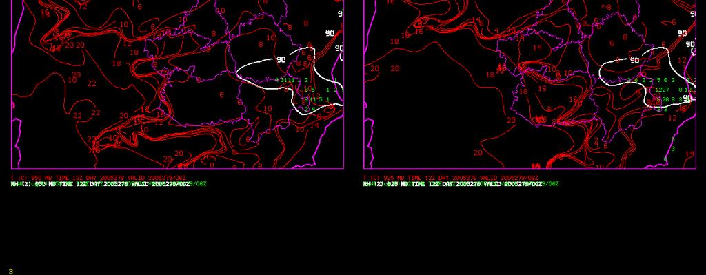
19 September 22, FG PWBL 18:00 D-1 PWBL 06:00 D " The bank of fog in the morning will go up to where the maritime wind penetrated in the region the previous evening.
20 September 22, PWBL evolution ( every 3 hours from the 18) The white arrows indicate the katabatic, and red one the humid advection. In the zone indicated with a square, the humidity continues entering during the night by the Jucar Valleys. The humidity gradient increases in that zone.
21 Principal problems and future projects The daily oscillation in stability conditions might be caused by some thermal channel. It would be desirable to analyze the contributions from every channel to this oscillation. The temporary resolution of the radiosondage information (12 a.m. and 00 a.m.) is not appropiate to detect the phenomenon. At these hours we might be in two similar minimum values, giving the impression that there is no daily variation. A climatology of PWBL values would help us to understand the phenomenum and to confirm the proposed process. At the moment, it is only a subjective vision. These climatologies should be hourly. The moment of maximum or minimun can change throughout the year.
22 Principal problems and future projects The conceptual model should be applied independently to each valley, due to the influence of the different highs of the valleys. We could to do that by taking the PWBL climatology from an average clear days as a reference. The difference between the present day and the average clear day can be calculated in order to highlight the phenomenum. Some trails have been done with data from a whole month. The results look promising.


23 Principal problems and future projects The problem whith the Cloudy Mask. There is a case in which the Cloudy Mask gives sign of clouds that does not exist.

24

25
A SEVERE WEATHER EVENT IN ROMANIA DUE TO MEDITERRANEAN CYCLONIC ACTIVITY
 A SEVERE WEATHER EVENT IN ROMANIA DUE TO MEDITERRANEAN CYCLONIC ACTIVITY Florinela Georgescu, Gabriela Bancila, Viorica Dima National Meteorological Administration, Bucharest, Romania Abstract Mediterranean
ESCI 344 Tropical Meteorology Lesson 7 Temperature, Clouds, and Rain
 ESCI 344 Tropical Meteorology Lesson 7 Temperature, Clouds, and Rain References: Forecaster s Guide to Tropical Meteorology (updated), Ramage Tropical Climatology, McGregor and Nieuwolt Climate and Weather
GEO1010 tirsdag
 GEO1010 tirsdag 31.08.2010 Jørn Kristiansen; jornk@met.no I dag: Først litt repetisjon Stråling (kap. 4) Atmosfærens sirkulasjon (kap. 6) Latitudinal Geographic Zones Figure 1.12 jkl TØRR ATMOSFÆRE Temperature
Page 1. Name:
 Name: 1) As the difference between the dewpoint temperature and the air temperature decreases, the probability of precipitation increases remains the same decreases 2) Which statement best explains why
Air Pollution Meteorology
 Air Pollution Meteorology Government Pilots Utilities Public Farmers Severe Weather Storm / Hurricane Frost / Freeze Significant Weather Fog / Haze / Cloud Precipitation High Resolution Weather & Dispersion
Charles A. Doswell III, Harold E. Brooks, and Robert A. Maddox
 Charles A. Doswell III, Harold E. Brooks, and Robert A. Maddox Flash floods account for the greatest number of fatalities among convective storm-related events but it still remains difficult to forecast
VERIFICATION OF HIGH-RESOLUTION MESOSCALE SIMULATIONS USING LAND-SURFACE TEMPERATURE FIELDS DERIVED FROM SATELLITES
 VERIFICATION OF HIGH-RESOLUTION MESOSCALE SIMULATIONS USING LAND-SURFACE TEMPERATURE FIELDS DERIVED FROM SATELLITES M.A. Jiménez and J.Cuxart Universitat de les Illes Balears Palma de Mallorca, Spain ü
Romanian Contribution in Quantitative Precipitation Forecasts Project
 3 Working Group on Physical Aspects 29 Romanian Contribution in Quantitative Precipitation Forecasts Project Rodica Dumitrache, Victor Pescaru, Liliana Velea, Cosmin Barbu National Meteorological Administration,
Severe weather. Some case studies for medium-range forecasting. T. La Rocca, Department of Synoptic Meteorology, Italian Met. Service, Rome.
 Severe weather. Some case studies for medium-range forecasting T. La Rocca, Department of Synoptic Meteorology, Italian Met. Service, Rome. The Met Alert Messages by the Watch Office of the Public Safety
WATER VAPOUR IMAGERY ANALYSIS IN 7.3µ/6.2µ FOR DIAGNOSING THERMO-DYNAMIC CONTEXT OF INTENSE CONVECTION
 WATER VAPOUR IMAGERY ANALYSIS IN 7.3µ/6.2µ FOR DIAGNOSING THERMO-DYNAMIC CONTEXT OF INTENSE CONVECTION P. Santurette 1 and C.G. Georgiev 2 1 Météo-France, 42, Avenue G. Coriolis, 31057 Toulouse Cedex 01,
Practical Atmospheric Analysis
 Chapter 12 Practical Atmospheric Analysis With the ready availability of computer forecast models and statistical forecast data, it is very easy to prepare a forecast without ever looking at actual observations,
Inflow and Outflow through the Sea-to-Sky Corridor in February 2010: Lessons Learned from SNOW-V10 *
 Inflow and Outflow through the Sea-to-Sky Corridor in February 2010: Lessons Learned from SNOW-V10 * Ruping Mo National Laboratory for Coastal and Mountain Meteorology, Environment Canada, Vancouver, BC,
Fog forecast in Oltenia
 Fog forecast in Oltenia Şerban-Eugen Iordăchescu, Magdalena Iordăchescu Regional Meteorological Center Oltenia, Weather Service Forecast Craiova 105 Calea Bucuresti, Craiova, Dolj, Romania e-mail: sebi_iordachescu@yahoo.com,
Synoptic Analysis of Total Rainfall Patterns at Azerbaijan District.
 Synoptic Analysis of Total Rainfall Patterns at Azerbaijan District Samad Vahdati 1, Shahrokh Shahrokhi Shirvani 2, Abolfazl Nazari Giglou 3 1,3 Department of Civil Engineering, Parsabad Moghan Branch,
MET 3502 Synoptic Meteorology. Lecture 8: September 16, AIRMASSES, FRONTS and FRONTAL ANALYSIS (2)
") MET 3502 Synoptic Meteorology Lecture 8: September 16, 2010 AIRMASSES, FRONTS and FRONTAL ANALYSIS (2) Identifying a cold front on a surface weather map: 1. Surface front is located at the leading edge
MET 3502 Synoptic Meteorology Lecture 8: September 16, 2010 AIRMASSES, FRONTS and FRONTAL ANALYSIS (2) Identifying a cold front on a surface weather map: 1. Surface front is located at the leading edge
Where does precipitation water come from?
 Chapter II Climate and Meteorology Where does precipitation water come from? Introduction The source of water vapor existing over Mongolia has been considered to consist of evapotranspiration at several
QUALITY OF MPEF DIVERGENCE PRODUCT AS A TOOL FOR VERY SHORT RANGE FORECASTING OF CONVECTION
 QUALITY OF MPEF DIVERGENCE PRODUCT AS A TOOL FOR VERY SHORT RANGE FORECASTING OF CONVECTION C.G. Georgiev 1, P. Santurette 2 1 National Institute of Meteorology and Hydrology, Bulgarian Academy of Sciences
Transient and Eddy. Transient/Eddy Flux. Flux Components. Lecture 3: Weather/Disturbance. Transient: deviations from time mean Time Mean
 Lecture 3: Weather/Disturbance Transients and Eddies Climate Roles Mid-Latitude Cyclones Tropical Hurricanes Mid-Ocean Eddies Transient and Eddy Transient: deviations from time mean Time Mean Eddy: deviations
Type of storm viewed by Spotter A Ordinary, multi-cell thunderstorm. Type of storm viewed by Spotter B Supecell thunderstorm
 ANSWER KEY Part I: Locating Geographical Features 1. The National Weather Service s Storm Prediction Center (www.spc.noaa.gov) has issued a tornado watch on a warm spring day. The watch covers a large
For the operational forecaster one important precondition for the diagnosis and prediction of
 Initiation of Deep Moist Convection at WV-Boundaries Vienna, Austria For the operational forecaster one important precondition for the diagnosis and prediction of convective activity is the availability
1. COLD FRONT - CLOUD STRUCTURE IN SATELLITE IMAGES
 1. COLD FRONT - CLOUD STRUCTURE IN SATELLITE IMAGES The satellite image shows a cyclonically curved synoptic scale cloud band usually a few hundred kilometres wide; in the VIS image the cloud band mostly
Synoptic Meteorology II: Frontogenesis Examples Figure 1
 Synoptic Meteorology II: Frontogenesis Examples The below images, taken from the 1200 UTC 17 January 2019 GFS forecast run, provide examples of the contributions of deformation and divergence to frontogenesis.
Page 1. Name: 4) State the actual air pressure, in millibars, shown at Miami, Florida on the given weather map.
 State the actual air pressure, in millibars, shown at Miami, Florida on the given weather map.") Name: Questions 1 and 2 refer to the following: A partial station model and meteorological conditions table, as reported by the weather bureau in the city of Oswego, New York, are shown below. 1) Using
Name: Questions 1 and 2 refer to the following: A partial station model and meteorological conditions table, as reported by the weather bureau in the city of Oswego, New York, are shown below. 1) Using
ABSTRACT 1.-INTRODUCTION
 Characterization of wind fields at a regional scale calculated by means of a diagnostic model using multivariate techniques M.L. Sanchez, M.A. Garcia, A. Calle Laboratory of Atmospheric Pollution, Dpto
Anthony A. Rockwood Robert A. Maddox
 Anthony A. Rockwood Robert A. Maddox An unusually intense MCS produced large hail and wind damage in northeast Kansas and northern Missouri during the predawn hours of June 7 th, 1982. Takes a look at
Quiz 2 Review Questions
 Quiz 2 Review Questions Chapter 7 Lectures: Winds and Global Winds and Global Winds cont 1) What is the thermal circulation (thermal wind) and how does it form? When we have this type of circulation, how
Urban heat island in the metropolitan area of São Paulo and the influence of warm and dry air masses during summer
 Urban heat island in the metropolitan area of São Paulo and the influence of warm and dry air masses during summer Flavia N. D. Ribeiro1, Arissa S. umezaki1, Jhonathan F. T. de Souza1, Jacyra Soares2,
Nerushev A.F., Barkhatov A.E. Research and Production Association "Typhoon" 4 Pobedy Street, , Obninsk, Kaluga Region, Russia.
 DETERMINATION OF ATMOSPHERIC CHARACTERISTICS IN THE ZONE OF ACTION OF EXTRA-TROPICAL CYCLONE XYNTHIA (FEBRUARY 2010) INFERRED FROM SATELLITE MEASUREMENT DATA Nerushev A.F., Barkhatov A.E. Research and
p = ρrt p = ρr d = T( q v ) dp dz = ρg
 dp dz = ρg") Chapter 1: Properties of the Atmosphere What are the major chemical components of the atmosphere? Atmospheric Layers and their major characteristics: Troposphere, Stratosphere Mesosphere, Thermosphere
Chapter 1: Properties of the Atmosphere What are the major chemical components of the atmosphere? Atmospheric Layers and their major characteristics: Troposphere, Stratosphere Mesosphere, Thermosphere
Weather Related Factors of the Adelaide floods ; 7 th to 8 th November 2005
 Weather Related Factors of the Adelaide floods ; th to th November 2005 Extended Abstract Andrew Watson Regional Director Bureau of Meteorology, South Australian Region 1. Antecedent Weather 1.1 Rainfall
Summary of High Wind Event of 7 March 2004
 Summary of High Wind Event of 7 March 2004 This event was characterized by a very strong jet streak that developed over North Carolina by 00 UTC 8 March, as seen in the Eta model analysis at 300 mb, with
Logistics. Goof up P? R? Can you log in? Requests for: Teragrid yes? NCSA no? Anders Colberg Syrowski Curtis Rastogi Yang Chiu
 Logistics Goof up P? R? Can you log in? Teragrid yes? NCSA no? Requests for: Anders Colberg Syrowski Curtis Rastogi Yang Chiu Introduction to Numerical Weather Prediction Thanks: Tom Warner, NCAR A bit
Using Temperature and Dew Point to Aid Forecasting Springtime Radiational Frost and/or Freezing Temperatures in the NWS La Crosse Service Area
 Using Temperature and Dew Point to Aid Forecasting Springtime Radiational Frost and/or Freezing Temperatures in the NWS La Crosse Service Area WFO La Crosse Climatology Series #21 The formation of radiational
INTERPRETATION GUIDE TO MSG WATER VAPOUR CHANNELS
 INTERPRETATION GUIDE TO MSG WATER VAPOUR CHANNELS C.G. Georgiev1 and P. Santurette2 1 National Institute of Meteorology and Hydrology, Tsarigradsko chaussee 66, 1784 Sofia, Bulgaria 2 Météo-France, 42,
Weather Systems Study Guide:
 Weather Systems Study Guide: 1. Draw a diagram of Earth s water cycle and label each part. 2. Explain how the water cycle works. 3. What happens in the troposphere and stratosphere? Atmosphere Level What
Occlusion Cyclogenesis
 Occlusion Cyclogenesis Part I: Occlusion cloud bands in comparison to CF and WFs Concepts for cyclogenesis Different types of cyclogenesis and examples Numerical parameters on isobaric and isentropic surfaces
Application of microwave radiometer and wind profiler data in the estimation of wind gust associated with intense convective weather
 Application of microwave radiometer and wind profiler data in the estimation of wind gust associated with intense convective weather P W Chan 1 and K H Wong 2 1 Hong Kong Observatory, 134A Nathan Road,
Paper 1 Lithosphere and Atmosphere October/November 2006
 Centre Number Candidate Number Name UNIVERSITY OF CAMBRIDGE INTERNATIONAL EXAMINATIONS General Certificate of Education Advanced Subsidiary Level and Advanced Level ENVIRONMENTAL MANAGEMENT 8291/01 Paper
Climate. Annual Temperature (Last 30 Years) January Temperature. July Temperature. Average Precipitation (Last 30 Years)
 January Temperature. July Temperature. Average Precipitation (Last 30 Years)") Climate Annual Temperature (Last 30 Years) Average Annual High Temp. (F)70, (C)21 Average Annual Low Temp. (F)43, (C)6 January Temperature Average January High Temp. (F)48, (C)9 Average January Low Temp.
Climate Annual Temperature (Last 30 Years) Average Annual High Temp. (F)70, (C)21 Average Annual Low Temp. (F)43, (C)6 January Temperature Average January High Temp. (F)48, (C)9 Average January Low Temp.
OBJECTIVE USE OF HIGH RESOLUTION WINDS PRODUCT FROM HRV MSG CHANNEL FOR NOWCASTING PURPOSES
 OBJECTIVE USE OF HIGH RESOLUTION WINDS PRODUCT FROM HRV MSG CHANNEL FOR NOWCASTING PURPOSES José Miguel Fernández Serdán, Javier García Pereda Servicio de Técnicas de Análisis y Predicción, Servicio de
Objective 3: Earth and Space Systems
 Name Class Period: Objective 3: Earth and Space Systems 1. The diagram above shows the orbit of the moon around Earth. At which point in the moon s orbit will a person standing on Earth see a waxing crescent
3. As warm, moist air moves into a region, barometric pressure readings in the region will generally 1. decrease 2. increase 3.
 Teacher: Mr. Prizzi Castle Learning Review 1 1. Which process most directly results in cloud formation? 1. condensation 3. precipitation 2. transpiration 4. radiation 2. An air mass originating over north
DEPARTMENT OF EARTH & CLIMATE SCIENCES Name SAN FRANCISCO STATE UNIVERSITY Nov 29, ERTH 360 Test #2 200 pts
 DEPARTMENT OF EARTH & CLIMATE SCIENCES Name SAN FRANCISCO STATE UNIVERSITY Nov 29, 2018 ERTH 360 Test #2 200 pts Each question is worth 4 points. Indicate your BEST CHOICE for each question on the Scantron
Science 1206 Chapter 1 - Inquiring about Weather
 Science 1206 Chapter 1 - Inquiring about Weather 1.1 - The Atmosphere: Energy Transfer and Properties (pp. 10-25) Weather and the Atmosphere weather the physical conditions of the atmosphere at a specific
Application and verification of ECMWF products 2011
 Application and verification of ECMWF products 2011 National Meteorological Administration 1. Summary of major highlights Medium range weather forecasts are primarily based on the results of ECMWF and
Chapter 7 Properties of the Atmosphere
 14. Day Breezes H L Chapter 7 Properties of the Atmosphere Questions Pages 177 179 1. (3) 2. (4) 3. (4) 4. (3) 5. (2) 6. (3) 7. (2) 8. (2) 9. (3) 10. (1) 11. (4) 12. (2) Questions Pages 186 188 13. (3)
Chapter 12 Fronts & Air Masses
 Chapter overview: Anticyclones or highs Air Masses o Classification o Source regions o Air masses of North America Fronts o Stationary fronts o Cold fronts o Warm fronts o Fronts and the jet stream o Frontogenesis
MICROPHYSICAL ANALYSIS OF SNOWFALL EPISODES THROUGH THE DISPERSION PROFILES
 MICROPHYSICAL ANALYSIS OF SNOWFALL EPISODES THROUGH THE DISPERSION PROFILES Laura López (1), José Prieto (2), J.L. Sánchez (1), E. García-Ortega (1), Rafael Posada (1) (1) Group for Atmospheric Physics,
MAURITIUS METEOROLOGICAL SERVICES
 MAURITIUS METEOROLOGICAL SERVICES CLIMATE NOVEMBER 2018 Introduction Climatologically speaking, November is a relatively dry month for Mauritius with a long term monthly mean rainfall of 78 mm. However,
The water vapour channels of SEVIRI (Meteosat). An introduction
. An introduction") The water vapour channels of SEVIRI (Meteosat). An introduction jose.prieto@eumetsat.int Cachoeira P. July 2006 Formats 1.5 1 Objectives 2 Describe the characteristics of WV channels on board of SEVIRI
The water vapour channels of SEVIRI (Meteosat). An introduction jose.prieto@eumetsat.int Cachoeira P. July 2006 Formats 1.5 1 Objectives 2 Describe the characteristics of WV channels on board of SEVIRI
INVESTIGATION FOR A POSSIBLE INFLUENCE OF IOANNINA AND METSOVO LAKES (EPIRUS, NW GREECE), ON PRECIPITATION, DURING THE WARM PERIOD OF THE YEAR
, ON PRECIPITATION, DURING THE WARM PERIOD OF THE YEAR") Proceedings of the 13 th International Conference of Environmental Science and Technology Athens, Greece, 5-7 September 2013 INVESTIGATION FOR A POSSIBLE INFLUENCE OF IOANNINA AND METSOVO LAKES (EPIRUS,
Proceedings of the 13 th International Conference of Environmental Science and Technology Athens, Greece, 5-7 September 2013 INVESTIGATION FOR A POSSIBLE INFLUENCE OF IOANNINA AND METSOVO LAKES (EPIRUS,
Lesson 2C - Weather. Lesson Objectives. Fire Weather
 Lesson 2C - Weather 2C-1-S190-EP Lesson Objectives 1. Describe the affect of temperature and relative humidity has on wildland fire behavior. 2. Describe the affect of precipitation on wildland fire behavior.
1. Which weather map symbol is associated with extremely low air pressure? A) B) C) D) 2. The diagram below represents a weather instrument.
 B) C) D) 2. The diagram below represents a weather instrument.") 1. Which weather map symbol is associated with extremely low air pressure? 2. The diagram below represents a weather instrument. Which weather variable was this instrument designed to measure? A) air pressure
1. Which weather map symbol is associated with extremely low air pressure? 2. The diagram below represents a weather instrument. Which weather variable was this instrument designed to measure? A) air pressure
WMO technical conference on climate services building on clips legacy
 WMO technical conference on climate services building on clips legacy conjunction with the Sixteenth Session of WMO Commission for Climatology (CCl-16) and the 35 th Meeting of the Joint Scientific Committee
Plan for operational nowcasting system implementation in Pulkovo airport (St. Petersburg, Russia)
") Plan for operational nowcasting system implementation in Pulkovo airport (St. Petersburg, Russia) Pulkovo airport (St. Petersburg, Russia) is one of the biggest airports in the Russian Federation (150
Plan for operational nowcasting system implementation in Pulkovo airport (St. Petersburg, Russia) Pulkovo airport (St. Petersburg, Russia) is one of the biggest airports in the Russian Federation (150
Precipitation processes in the Middle East
 Precipitation processes in the Middle East J. Evans a, R. Smith a and R.Oglesby b a Dept. Geology & Geophysics, Yale University, Connecticut, USA. b Global Hydrology and Climate Center, NASA, Alabama,
Boundary layer equilibrium [2005] over tropical oceans
![Boundary layer equilibrium [2005] over tropical oceans](/thumbs/96/128963638.jpg "Boundary layer equilibrium [2005] over tropical oceans") Boundary layer equilibrium [2005] over tropical oceans Alan K. Betts [akbetts@aol.com] Based on: Betts, A.K., 1997: Trade Cumulus: Observations and Modeling. Chapter 4 (pp 99-126) in The Physics and Parameterization
Boundary layer equilibrium [2005] over tropical oceans Alan K. Betts [akbetts@aol.com] Based on: Betts, A.K., 1997: Trade Cumulus: Observations and Modeling. Chapter 4 (pp 99-126) in The Physics and Parameterization
Lecture 12. The diurnal cycle and the nocturnal BL
 Lecture 12. The diurnal cycle and the nocturnal BL Over flat land, under clear skies and with weak thermal advection, the atmospheric boundary layer undergoes a pronounced diurnal cycle. A schematic and
Hiking accidents and strong northerly winds over Mediterranean Pyrenees
 Hiking accidents and strong northerly winds over Mediterranean Pyrenees Ramón Pascual and Alfons Callado Meteorological Center. INM. Barcelona, Catalonia, Spain El Escorial, October, 2007 11 1 Geographical
How Can You Predict Weather Changes?
 How Can You Predict Weather Changes? How to Predict Weather Meteorologists make weather predictions daily. They use the same processes that you will. They collect weather data. They plot the data on maps.
SESSION 9: CLIMATE AND WEATHER, FLUVIAL PROCESSES AND MAPWORK
 SESSION 9: CLIMATE AND WEATHER, FLUVIAL PROCESSES AND MAPWORK KEY CONCEPTS: In this session we will: Integrate theory and mapwork. Look specifically at how climate and weather and fluvial processes can
Weather Studies Introduction to Atmospheric Science
 Weather Studies Introduction to Atmospheric Science American Meteorological Society Chapter 1 Monitoring The Weather Credit: This presentation was prepared for AMS by Michael Leach, Professor of Geography
Synoptic type analysis of coastal fog occurred at the. Korean west sea
 Synoptic type analysis of coastal fog occurred at the Korean west sea Pak JongGil 1, Jang DongChol 1, Kim SuSong 2, Ri DuYon 1, Choe YongHo 1, Ja Yon grim 1, DokGo HyokChol 1 1 State hydrometeorology administration
Unit 4 Review Guide: Weather
 Unit 4 Review Guide: Weather Weather: The condition of the atmosphere at a specific time and place. Freezing: To become hardened into ice or into a solid body Deposition: The change in state of matter
5 Atmospheric Disturbances 7 1.Cyclones- tropical and temperate and associated weather conditions. 2.Anticyclones and associated weather conditions.
 5 Atmospheric Disturbances 7 1.Cyclones- tropical and temperate and associated weather conditions. 2.Anticyclones and associated weather conditions. atmospheric disturbances (weather systems) that are
DEPARTMENT OF GEOSCIENCES SAN FRANCISCO STATE UNIVERSITY. Metr Fall 2012 Test #1 200 pts. Part I. Surface Chart Interpretation.
 DEPARTMENT OF GEOSCIENCES SAN FRANCISCO STATE UNIVERSITY NAME Metr 356.01 Fall 2012 Test #1 200 pts Part I. Surface Chart Interpretation. Figure 1. Surface Chart for 1500Z 7 September 2007 1 1. Pressure
CONSTRUCTION OF CLOUD TRAJECTORIES AND MOTION OF CIRRUS CLOUDS AND WATER VAPOUR STRUCTURES
 CONSTRUCTION OF CLOUD TRAJECTORIES AND MOTION OF CIRRUS CLOUDS AND WATER VAPOUR STRUCTURES André SZANTAI +, Michel DESBOIS +, Laurence PICON +, Henri LAURENT *, Françoise DESALMAND + + Laboratoire de Météorologie
Answers to Clicker Questions
 Answers to Clicker Questions Chapter 1 What component of the atmosphere is most important to weather? A. Nitrogen B. Oxygen C. Carbon dioxide D. Ozone E. Water What location would have the lowest surface
Application and verification of ECMWF products 2012
 Application and verification of ECMWF products 2012 Instituto Português do Mar e da Atmosfera, I.P. (IPMA) 1. Summary of major highlights ECMWF products are used as the main source of data for operational
InSAR measurements of volcanic deformation at Etna forward modelling of atmospheric errors for interferogram correction
 InSAR measurements of volcanic deformation at Etna forward modelling of atmospheric errors for interferogram correction Rachel Holley, Geoff Wadge, Min Zhu Environmental Systems Science Centre, University
Fig. 1; Relative frequency (white) and persistence (dashed) for the OSPs.
 and persistence (dashed) for the OSPs.") OBJECTIVE TOOLS FOR THE STUDY OF THE RELATIONSHIP BETWEEN SYNOPTIC SCALE METEOROLOGY AND AIR POLLUTION Cecilia Soriano 1, Javier Remón 1, Antonio Fernández 2, Javier Martín-Vide 3 and Rosa Soler 4 1 Universitat
OBJECTIVE TOOLS FOR THE STUDY OF THE RELATIONSHIP BETWEEN SYNOPTIC SCALE METEOROLOGY AND AIR POLLUTION Cecilia Soriano 1, Javier Remón 1, Antonio Fernández 2, Javier Martín-Vide 3 and Rosa Soler 4 1 Universitat
Departmento de Impacto Ambiental de la Energía, Centro de Investigaciones Energéticas, Medioambientales y Tecnológicas, Madrid, Spain
 880 JOURNAL OF APPLIED METEOROLOGY Simulations of Mesoscale Circulations in the Center of the Iberian Peninsula for Thermal Low Pressure Conditions. Part I: Evaluation of the Topography Vorticity-Mode
Mid-Latitude Cyclones and Fronts. Lecture 12 AOS 101
 Mid-Latitude Cyclones and Fronts Lecture 12 AOS 101 Homework 4 COLDEST TEMPS GEOSTROPHIC BALANCE Homework 4 FASTEST WINDS L Consider an air parcel rising through the atmosphere The parcel expands as it
WMO Aeronautical Meteorology Scientific Conference 2017
 Session 1 Science underpinning meteorological observations, forecasts, advisories and warnings 1.6 Observation, nowcast and forecast of future needs 1.6.1 Advances in observing methods and use of observations
P2.11 THE LAKE SHADOW EFFECT OF LAKE BREEZE CIRCULATIONS AND RECENT EXAMPLES FROM GOES VISIBLE SATELLITE IMAGERY. Frank S. Dempsey
 P2.11 THE LAKE SHADOW EFFECT OF LAKE BREEZE CIRCULATIONS AND RECENT EXAMPLES FROM GOES VISIBLE SATELLITE IMAGERY Frank S. Dempsey 1. ABSTRACT The lake shadow effect is a component of the lake breeze circulation
Weather Practice. 4. As wind velocity decreases, the distance between isobars on a weather map will A) decrease B) increase C) remain the same
 decrease B) increase C) remain the same") 1. The chart below shows the air temperature and the dewpoint temperature near the ground at a given location for four consecutive days. All temperatures were recorded at noon. Which statement is best
1. The chart below shows the air temperature and the dewpoint temperature near the ground at a given location for four consecutive days. All temperatures were recorded at noon. Which statement is best
C
 C 0.8 0.4 0.2 0.0-0.2-0.6 Fig. 1. SST-wind relation in the North Pacific and Atlantic Oceans. Left panel: COADS SST (color shade), surface wind vectors, and SLP regressed upon the Pacific Decadal Oscillation
Lecture 4 Air Temperature. Measuring Temperature. Measuring Temperature. Surface & Air Temperature. Environmental Contrasts 3/27/2012
 Lecture 4 Air Temperature Geo210 An Introduction to Physical Geography Temperature Concepts and Measurement Temperature the average kinetic energy (motion) of molecules of matter Temperature Scales Fahrenheit
Utilising Radar and Satellite Based Nowcasting Tools for Aviation Purposes in South Africa. Erik Becker
 Utilising Radar and Satellite Based Nowcasting Tools for Aviation Purposes in South Africa Erik Becker Morné Gijben, Mary-Jane Bopape, Stephanie Landman South African Weather Service: Nowcasting and Very
Average Weather In March For Fukuoka, Japan
 Average Weather In March For Fukuoka, Japan Location This report describes the typical weather at the Fukuoka Airport (Fukuoka, Japan) weather station over the course of an average March. It is based on
DESCRIPTION AND VALIDATION RESULTS OF THE HIGH RESOLUTION WIND PRODUCT FROM HRVIS MSG CHANNEL, AT EUMETSAT NOWCASTING SAF (SAFNWC)
") DESCRIPTION AND VALIDATION RESULTS OF THE HIGH RESOLUTION WIND PRODUCT FROM HRVIS MSG CHANNEL, AT EUMETSAT NOWCASTING SAF (SAFNWC) Javier García Pereda, José Miguel Fernández Serdán Servicio de Teledetección,
DESCRIPTION AND VALIDATION RESULTS OF THE HIGH RESOLUTION WIND PRODUCT FROM HRVIS MSG CHANNEL, AT EUMETSAT NOWCASTING SAF (SAFNWC) Javier García Pereda, José Miguel Fernández Serdán Servicio de Teledetección,
2. What are the four most common gasses in the atmosphere and their percentages?
 Meteorology Review Directions: Answer the following open ended review questions. Utilize a diagram where appropriate and do make sure that you label and describe the drawing. Atmospheric Composition 1.
Weather, Air Masses, Fronts and Global Wind Patterns. Meteorology
 Weather, Air Masses, Fronts and Global Wind Patterns Meteorology Weather is what conditions of the atmosphere are over a short period of time. Climate is how the atmosphere "behaves" over long periods
Climatology of Paranal. Prepared by M. Sarazin, ESO
 Climatology of Paranal Prepared by M. Sarazin, ESO 1 Climatology of Paranal The Main Climate Actors The Main Parameters And their Climatology 2 Main Climate Actors Bolivian High El Nino Southern Oscillation
CHAPTER 13 WEATHER ANALYSIS AND FORECASTING MULTIPLE CHOICE QUESTIONS
 CHAPTER 13 WEATHER ANALYSIS AND FORECASTING MULTIPLE CHOICE QUESTIONS 1. The atmosphere is a continuous fluid that envelops the globe, so that weather observation, analysis, and forecasting require international
Polar Lows and other High Latitude Weather Systems. John Turner and Tom Bracegirdle British Antarctic Survey Cambridge, UK
 Polar Lows and other High Latitude Weather Systems John Turner and Tom Bracegirdle British Antarctic Survey Cambridge, UK A mosaic of infra-red satellite imagery of the Antarctic and Southern Ocean on
and 24 mm, hPa lapse rates between 3 and 4 K km 1, lifted index values
 3.2 Composite analysis 3.2.1 Pure gradient composites The composite initial NE report in the pure gradient northwest composite (N = 32) occurs where the mean sea level pressure (MSLP) gradient is strongest
Synoptic Meteorology I: Skew-T Diagrams and Thermodynamic Properties
 Synoptic Meteorology I: Skew-T Diagrams and Thermodynamic Properties For Further Reading Most information contained within these lecture notes is drawn from Chapters 1, 2, 4, and 6 of The Use of the Skew
Atmosphere and Weather Revision Notes
 Atmosphere and Weather Revision Notes Atmosphere The blanket of gases that surrounds the Earth is called the atmosphere. The main gases are nitrogen (78 %), oxygen (21 %), water vapour, ozone and carbon
22nd-26th February th International Wind Workshop Tokyo, Japan
 New developments in the High Resolution Winds Product (HRW), at the Satellite Application Facility on support to Nowcasting and Very short range forecasting (NWCSAF) 22nd-26th February 2010 10th International
PRECONVECTIVE SOUNDING ANALYSIS USING IASI AND MSG- SEVIRI
 PRECONVECTIVE SOUNDING ANALYSIS USING IASI AND MSG- SEVIRI Marianne König, Dieter Klaes EUMETSAT, Eumetsat-Allee 1, 64295 Darmstadt, Germany Abstract EUMETSAT operationally generates the Global Instability
ABSTRACT INTRODUCTION
 Application of a non-hydrostatic mesoscale meteorological model to the Aveiro Region, Portugal M. Coutinho," T. Flassak,* C. Borrego" ^Department of Environmental and Planning, University of Aveiro, 3800
Name: Regents Earth Science. Weather and Climate - Review Questions
 Name: Regents Earth Science Weather and Climate - Review Questions Date: Thayer - 279 1. People sometimes release substances into the atmosphere to increase the probability of rain by A) raising the air
Tropical Cyclone Formation/Structure/Motion Studies
 Tropical Cyclone Formation/Structure/Motion Studies Patrick A. Harr Department of Meteorology Naval Postgraduate School Monterey, CA 93943-5114 phone: (831) 656-3787 fax: (831) 656-3061 email: paharr@nps.edu
eport Nataša Strelec Mahović Meteorological and Hydrological Service, Grič 3, Zagreb, Croatia EUMeTrain project Abstract
 eport Nataša Strelec Mahović Meteorological and Hydrological Service, Grič 3, Zagreb, Croatia EUMeTrain project Abstract The paper presents the concept of eport, an interface enabling the combined analysis
True or false: The atmosphere is always in hydrostatic balance. A. True B. False
 Clicker Questions and Clicker Quizzes Clicker Questions Chapter 7 Of the four forces that affect the motion of air in our atmosphere, which is to thank for opposing the vertical pressure gradient force
PRACTICAL INTERPRETATION OF RASP SOUNDINGS. Jean Oberson, February 2010.
 PRACTICAL INTERPRETATION OF RASP SOUNDINGS Jean Oberson, www.soaringmeteo.ch, February 2010. Emagram (better referred to SkewT thermodynamic diagram) is actually a simple xy graph. The x axis represents
INFLUENCE OF LARGE-SCALE ATMOSPHERIC MOISTURE FLUXES ON THE INTERANNUAL TO MULTIDECADAL RAINFALL VARIABILITY OF THE WEST AFRICAN MONSOON
 3C.4 INFLUENCE OF LARGE-SCALE ATMOSPHERIC MOISTURE FLUXES ON THE INTERANNUAL TO MULTIDECADAL RAINFALL VARIABILITY OF THE WEST AFRICAN MONSOON Andreas H. Fink*, and Sonja Eikenberg University of Cologne,
Chapter 3. Materials and Methods
 Chapter 3 Materials and Methods CHAPTER3 MATERIALS AND METHODS The present study aims to identify the role of climatic factors in the dispersal of air pollutants released into the atmosphere at some important
New applications using real-time observations and ECMWF model data
 New applications using real-time observations and ECMWF model data 12 th Workshop on Meteorological Operational Systems Wim van den Berg [senior meteorological researcher, project coordinator] Overview