Polar Lows and other High Latitude Weather Systems. John Turner and Tom Bracegirdle British Antarctic Survey Cambridge, UK
|
|
|
- Bryce Whitehead
- 6 years ago
- Views:
Transcription
1 Polar Lows and other High Latitude Weather Systems John Turner and Tom Bracegirdle British Antarctic Survey Cambridge, UK


2 A mosaic of infra-red satellite imagery of the Antarctic and Southern Ocean on 21 August University of Wisconsin- Madison
 analysis.")
3 Overlaid satellite imagery and GFS model (NCEP) analysis. University of Wisconsin- Madison
 analysis.")
4 Overlaid satellite imagery and GFS model (NCEP) analysis. University of Wisconsin- Madison

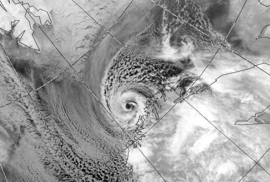
5 Synoptic and mesoscale weather systems near the tip of the Antarctic Peninsula

6 Outline Background history, definition The types of polar and the formation/development mechanisms Climatological occurrence Analysis, forecasting and modelling Future research needs and the IPY
7 The Nature of Polar Lows Occur poleward of the Polar Front Mesoscale <1,000 km diameter, <24 h lifetime A maritime phenomenon, declining rapidly over land Have winds in excess of gale force Usually occur during winter season The Arctic systems are more vigorous than their Antarctic counterparts because of the larger fluxes of heat and moisture from the ocean
8 Possible Climatological Importance Individual polar lows can have fluxes of heat of up to 1,000 Wm**2 The loss of heat from the ocean could trigger downward convection in the ocean But the frequent occurrence of polar lows would be needed in an area for this to be of climatological importance Modelling studies are needed to assess their importance
9 0 400 km
10 Nomenclature Polar lows have also been called: Arctic hurricane Arctic bomb Arctic instability lows Cold air depressions Comma clouds Mesocyclones My preferred choice: Polar lows for systems with winds > gale force Polar mesocyclones for weaker systems
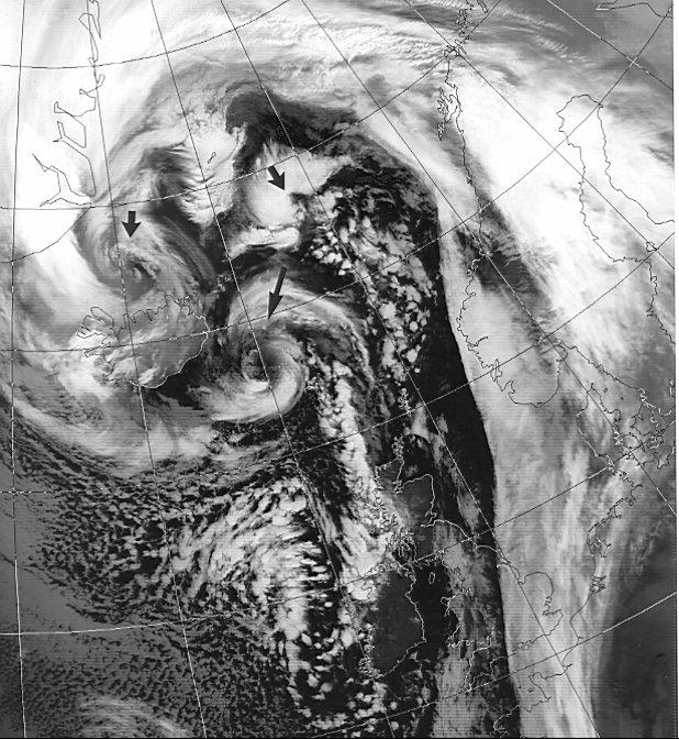
11 Early references During the Second World War the conveys to Russia via the Barents Sea reported very vigorous small weather systems Sumner (1950) reported hurricane-like centres within high latitude, synoptic- scale lows.
12
13 Peter Dannevig In 1954 wrote about instability lows over the sea areas around Norway in a book for pilots Produced a schematic weather chart showing the relationship between these vortices and the airflow around Norway
14
15 The Harrold and Browning Case (1969 QJ) The polar low as a baroclinic disturbance Developed a conceptual model for the low that crossed the UK on 9 December 1967
16 The Rasmussen Paper (1979 QJ) The polar low as an extratropical CISK disturbance Supported the old idea that polar lows were driven by deep convection and baroclinicity played only a small role


17 A Baroclinic Polar Low Over Denmark The broken line shows the main baroclinic zone Snow cover over Jutland is indicated by the white arrow

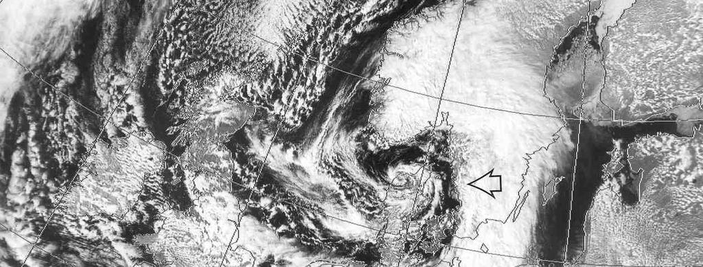
18 The Spiraliform Cloud Signature A polar low with spiraliform cloud signature off the northern coast of Norway Also indicated is a boundary layer front

19 The Comma Cloud Signature A rare high latitude comma cloud over the Barents Sea

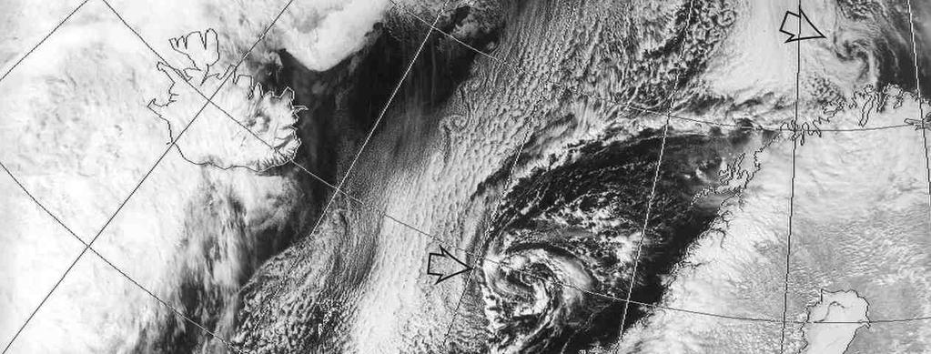
20 A Merry-Go-Round Polar Low A polar low with multiple centres over the Greenland / Norwegian Seas. Greenland Norway Iceland


21 The Instant Occlusion Process The polar low south of Iceland moves towards the wave on the polar front to form the instant occlusion
22 One Possible Polar Low Classification System 1. Reverse Shear systems 2. Trough systems 3. Boundary Layer Fronts 4. Cold Lows 5. Comma Clouds 6. Baroclinic-wave Forward Shear 7. Orographic Polar lows


23 Probably triggered by shortwave, upper trough. Baroclinic instability and deep convection play a part in the developments. 1. Reverse Shear Polar Lows


24 These systems often develop in trailing troughs associated with major synoptic scale lows. Again often triggered by short, UA troughs, or jet streaks. The cold air advection enhances convection. 2. Trough Systems

25 3. Boundary Layer Front Systems Boundary Layer fronts are frequently found over the Norwegian and Barents Seas, any many polar lows form on these features. The lows developing in these baroclinic regions are often short-lived.


26 Forming deep in the cold air, these lows often have spiral cloud patterns. They often develop within old cold core lows. They often form when the low moved over water. 4. Cold Low Types

27 A Cold Core Vortex Polar Low Over the Labrador Sea

28 These systems often form at much more southerly latitudes close to the polar front. They can often develop in more baroclinic regions in the cold air to the west of synoptic-scale lows. 5. Comma clouds


29 A baroclinic polar low that developed on a strong thermal gradient over the eastern Weddell Sea. 6. Baroclinic Waves

30 A baroclinic polar low that developed on a strong thermal gradient over the eastern Weddell Sea. 7. Orographic Polar Lows

31 CISK WISHE
32

33 The Seasonal Distribution of Polar Lows in the Norwegian Sea
34 Polar low tracks over the Norwegian and Barents Seas

35 The Harold Study Based on AVHRR Imagery
36 Two years of imagery were analysed and 4054 vortices identified! This figure shows the number of systems identified by diameter.

37 The tracks of systems in four diameter ranges

38 Larger vortices in the Harold study
39 The Condron and Bigg Study 1. Investigated mesoscale lows in the ERA-40 re-analysis 2. Used the Harold data base as truth 3. Automatically detected vortices using PMSL and 500 hpa height 4. Oct 1993 Sep 1995


40 Automatic detection of polar lows in ERA-40 Diamonds reanalysis (9) Circles/cross imagery (3)
41 The Condron and Bigg Study - Results 1. Up to 80% of cyclones larger than 500 km are detected in the MSLP field 2. This falls to 40% for 250 km vortices 3. Only 20% were detected for 100 km scale systems
42 The Monthly Number of Vortices Found in ERA-40

43 Cyclone Density From Imagery From ERA-40
44 Polar Lows in Other Areas Japan January 1987 Labrador Sea
45 Mesoscale Lows Around the Antarctic All vortices in March The contours indicate MSLP anomalies
46 Use of the UKMO Cyclone Database A database of cyclones objectively identified in the Met Office global model. It covers the period from January 2000 to April Hewson (2001). For each cyclone a range of diagnostics and variables are stored. Why choose the Cyclone Database to study polar lows? High resolution compared to reanalysis datasets. Designed to detect many features, including very weak disturbances. Typically 50 at any one time in the North Atlantic / Europe region.


47 Vortices identified in the UKMO cyclone data base Vortices identified in the AVHRR imagery
48 Spatial distribution of polar low activity Polar low count density from Jan 2000 to April 2004 calculated for area bins of ~125,000 km2 (200 km radius)
49 Spatial distribution of polar low activity Spitzbergen Norwegian Sea MIZ Barents Sea Davis Strait North Sea Denmark Strait
50 Static stability Baroclinicity (K/100 km)
 Infrared satellite")

51 Convective (marked by square on previous slide) Baroclinic (marked by circle on previous slide) Infrared satellite imagery for (a) /1/2002 and (b) /12/03. NOAA AVHRR imagery retrieved courtesy of the Dundee Satellite Receiving Station.
52 Conclusions of the Study Showed the potential for using operational analyses for investigating polar lows and other high latitude mesoscale vortices Over the 3 months from Dec % of the polar lows were represented in the UKMO analyses 76% of the polar mesocyclones (i.e. not polar lows) were in the cyclone data base Allowed the investigation of the processes involved in polar low development
53 Forecasting of Polar Lows Traditionally based on identification in satellite imagery and then a nowcasting approach Monitoring areas know for frequent polar low development during the polar low season Extra vigilance during cold air outbreaks Monitoring troughs behind synoptic scale lows for developments Frequent monitoring of infra-red red imagery Predicting the track with the 700/500 hpa winds

54 Woetman Nielsen s Case P October 1993 Image taken at 13:49 GMT 14 October 1993 Norway
55 A 48 h forecast of MSLP and 10 m wind vectors using the Danish HIRLAM model. Data time Oct 93 Verifying Oct 93
56 Surface analysis at 00 GMT 16 October 1993
57 Future Research Needs (1) The fact that modern operational analyses can represent polar lows opens up exciting possibilities A bi-polar data base of polar lows could be created The variability and trend in polar low occurrence could be investigated The Hewson data base of cyclones also contains data on systems in the forecasts what weight can we put on the forecasts of polar low development?
58 Future Research Needs Still debate over how convection acts to intensify the lows CISK, WISHE The operational analyses can provide insight into the environment of polar low development Are polar lows a distinct phenomenon or just part of the family of mesoscale lows?

59 A Polar Low over the Mediterranean 16 January 1995
60 The International Polar Year March 1997 to March 2009 The additional observations will hopefully results in very high quality analyses Provides an excellent opportunity to assess our ability to analyse and forecast polar lows


61

62 Thank You
Polar Lows and Other High Latitude Weather Systems
 Polar Lows and Other High Latitude Weather Systems John Turner and Tom Bracegirdle British Antarctic Survey, Cambridge, UK (J.Turner@bas.ac.uk) 1. Introduction Polar lows are mesoscale (less than 1,000
Forecasting Polar Lows. Gunnar Noer The Norwegian Meteorological Institute in Tromsø
 Forecasting Polar Lows Gunnar Noer The Norwegian Meteorological Institute in Tromsø Longyearbyen Hopen Bear Island Jan Mayen Tromsø Gunnar Noer Senior forecaster / developer for polar meteorology The Norwegian
Detection, tracking and study of polar lows from satellites Leonid P. Bobylev
 Detection, tracking and study of polar lows from satellites Leonid P. Bobylev Nansen Centre, St. Petersburg, Russia Nansen Centre, Bergen, Norway Polar lows and their general characteristics International
The Atmospheric Circulation
 The Atmospheric Circulation Vertical structure of the Atmosphere http://www.uwsp.edu/geo/faculty/ritter/geog101/textbook/atmosphere/atmospheric_structure.html The global heat engine [courtesy Kevin Trenberth,
Polar Mesoscale Cyclones in the Northeast Atlantic: Comparing Climatologies from ERA-40 and Satellite Imagery
 1518 M O N T H L Y W E A T H E R R E V I E W VOLUME 134 Polar Mesoscale Cyclones in the Northeast Atlantic: Comparing Climatologies from ERA-40 and Satellite Imagery ALAN CONDRON AND GRANT R. BIGG Department
A 2-year climatology of polar low events over the Nordic Seas from satellite remote sensing
 GEOPHYSICAL RESEARCH LETTERS, VOL. 35, L09815, doi:10.1029/2008gl033706, 2008 A 2-year climatology of polar low events over the Nordic Seas from satellite remote sensing A.-M. Blechschmidt 1 Received 20
The Arctic Energy Budget
 The Arctic Energy Budget The global heat engine [courtesy Kevin Trenberth, NCAR]. Differential solar heating between low and high latitudes gives rise to a circulation of the atmosphere and ocean that
Using Satellite Passive Microwave Data to Study Arctic Polar Lows
 Using Satellite Passive Microwave Data to Study Arctic Polar Lows Elizaveta V. Zabolotskikh 1,2, Leonid P. Bobylev 1,3, Vladimir Kudryavtsev 1,2, and Leonid Mitnik 4 1Nansen Centre, St. Petersburg, Russia
Satellite microwave observations and investigations of extreme events (polar lows) in the Arctic
 in the Arctic") Satellite microwave observations and investigations of extreme events (polar lows) in the Arctic Elizaveta Zabolotskikh, Vladimir Kudryavtsev, Pavel Golubkin, Olga Aniskina, and Bertrand Chapron Outline
Satellite microwave observations and investigations of extreme events (polar lows) in the Arctic Elizaveta Zabolotskikh, Vladimir Kudryavtsev, Pavel Golubkin, Olga Aniskina, and Bertrand Chapron Outline
Tropical Cyclone Formation/Structure/Motion Studies
 Tropical Cyclone Formation/Structure/Motion Studies Patrick A. Harr Department of Meteorology Naval Postgraduate School Monterey, CA 93943-5114 phone: (831) 656-3787 fax: (831) 656-3061 email: paharr@nps.edu
10B.2 THE ROLE OF THE OCCLUSION PROCESS IN THE EXTRATROPICAL-TO-TROPICAL TRANSITION OF ATLANTIC HURRICANE KAREN
 10B.2 THE ROLE OF THE OCCLUSION PROCESS IN THE EXTRATROPICAL-TO-TROPICAL TRANSITION OF ATLANTIC HURRICANE KAREN Andrew L. Hulme* and Jonathan E. Martin University of Wisconsin-Madison, Madison, Wisconsin
Multiscale Analyses of Inland Tropical Cyclone Midlatitude Jet Interactions: Camille (1969) and Danny (1997)
 and Danny (1997)") Multiscale Analyses of Inland Tropical Cyclone Midlatitude Jet Interactions: Camille (1969) and Danny (1997) Matthew Potter, Lance Bosart, and Daniel Keyser Department of Atmospheric and Environmental
Multiscale Analyses of Inland Tropical Cyclone Midlatitude Jet Interactions: Camille (1969) and Danny (1997) Matthew Potter, Lance Bosart, and Daniel Keyser Department of Atmospheric and Environmental
A Preliminary Climatology of Extratropical Transitions in the Southwest Indian Ocean
 A Preliminary Climatology of Extratropical Transitions in the Southwest Indian Ocean Kyle S. Griffin Department of Atmospheric and Environmental Sciences, University at Albany, State University of New
The North Atlantic Oscillation: Climatic Significance and Environmental Impact
 1 The North Atlantic Oscillation: Climatic Significance and Environmental Impact James W. Hurrell National Center for Atmospheric Research Climate and Global Dynamics Division, Climate Analysis Section
Satellites, Weather and Climate Module??: Polar Vortex
 Satellites, Weather and Climate Module??: Polar Vortex SWAC Jan 2014 AKA Circumpolar Vortex Science or Hype? Will there be one this year? Today s objectives Pre and Post exams What is the Polar Vortex
1. INTRODUCTION: 2. DATA AND METHODOLOGY:
 27th Conference on Hurricanes and Tropical Meteorology, 24-28 April 2006, Monterey, CA 3A.4 SUPERTYPHOON DALE (1996): A REMARKABLE STORM FROM BIRTH THROUGH EXTRATROPICAL TRANSITION TO EXPLOSIVE REINTENSIFICATION
Global Atmospheric Circulation
 Global Atmospheric Circulation Polar Climatology & Climate Variability Lecture 11 Nov. 22, 2010 Global Atmospheric Circulation Global Atmospheric Circulation Global Atmospheric Circulation The Polar Vortex
Tropical-Extratropical Transition
 Tropical-Extratropical Transition Extratropical Transition A significant number of tropical cyclones move into the midlatitudes and transform into extratropical cyclones. This process is generally referred
Extratropical and Polar Cloud Systems
 Extratropical and Polar Cloud Systems Gunilla Svensson Department of Meteorology & Bolin Centre for Climate Research George Tselioudis Extratropical and Polar Cloud Systems Lecture 1 Extratropical cyclones
3. Midlatitude Storm Tracks and the North Atlantic Oscillation
 3. Midlatitude Storm Tracks and the North Atlantic Oscillation Copyright 2006 Emily Shuckburgh, University of Cambridge. Not to be quoted or reproduced without permission. EFS 3/1 Review of key results
Satellites, Weather and Climate Module 9: Air/sea interactions winter cyclogenesis
 Satellites, Weather and Climate Module 9: Air/sea interactions winter cyclogenesis Winter storms things to consider Deep moisture Thermal discontinuity Favorable surface and upper level features Geographical
Dmitry Dukhovskoy and Mark Bourassa
 Dmitry Dukhovskoy and Mark Bourassa Center for Ocean-Atmospheric Prediction Studies Florida State University Funded by the NASA OVWST, HYCOM consortium and NSF AOMIP Acknowledgement: P. Hughes (FSU), E.J.
Synoptic Meteorology
 M.Sc. in Meteorology Synoptic Meteorology [MAPH P312] Prof Peter Lynch Second Semester, 2004 2005 Seminar Room Dept. of Maths. Physics, UCD, Belfield. Part 9 Extratropical Weather Systems These lectures
The feature of atmospheric circulation in the extremely warm winter 2006/2007
 The feature of atmospheric circulation in the extremely warm winter 2006/2007 Hiroshi Hasegawa 1, Yayoi Harada 1, Hiroshi Nakamigawa 1, Atsushi Goto 1 1 Climate Prediction Division, Japan Meteorological
The impact of polar mesoscale storms on northeast Atlantic Ocean circulation
 The impact of polar mesoscale storms on northeast Atlantic Ocean circulation Influence of polar mesoscale storms on ocean circulation in the Nordic Seas Supplementary Methods and Discussion Atmospheric
Diabatic processes and the structure of extratropical cyclones
 Geophysical and Nonlinear Fluid Dynamics Seminar AOPP, Oxford, 23 October 2012 Diabatic processes and the structure of extratropical cyclones Oscar Martínez-Alvarado R. Plant, J. Chagnon, S. Gray, J. Methven
Lecture 8. Monsoons and the seasonal variation of tropical circulation and rainfall
 Lecture 8 Monsoons and the seasonal variation of tropical circulation and rainfall According to the second hypothesis, the monsoon is a manifestation of the seasonal variation of the tropical circulation
An integrated assessment of the potential for change in storm activity over Europe: implications for forestry in the UK
 International Conference Wind Effects on Trees September 16-18, 3, University of Karlsruhe, Germany An integrated assessment of the potential for change in storm activity over Europe: implications for
A long-term climatology of North Atlantic polar lows
 Click Here for Full Article GEOPHYSICAL RESEARCH LETTERS, VOL. 35, L22702, doi:10.1029/2008gl035769, 2008 A long-term climatology of North Atlantic polar lows Matthias Zahn 1,2 and Hans von Storch 1,2
APPENDIX B PHYSICAL BASELINE STUDY: NORTHEAST BAFFIN BAY 1
 APPENDIX B PHYSICAL BASELINE STUDY: NORTHEAST BAFFIN BAY 1 1 By David B. Fissel, Mar Martínez de Saavedra Álvarez, and Randy C. Kerr, ASL Environmental Sciences Inc. (Feb. 2012) West Greenland Seismic
Subtropical and Hybrid Systems IWTC VII Topic 1.6
 Subtropical and Hybrid Systems IWTC VII Topic 1.6 John R. Gyakum Department of Atmospheric and Oceanic Sciences McGill University, Montreal Canada Working group: John L. Beven II, Lance F. Bosart, Fermin
Synoptic Meteorology II: Petterssen-Sutcliffe Development Theory Application March 2015
 Synoptic Meteorology II: Petterssen-Sutcliffe Development Theory Application 10-12 March 2015 In our lecture on Petterssen-Sutcliffe Development Theory, we outlined the principle of selfdevelopment in
ATMOSPHERIC MODELLING. GEOG/ENST 3331 Lecture 9 Ahrens: Chapter 13; A&B: Chapters 12 and 13
 ATMOSPHERIC MODELLING GEOG/ENST 3331 Lecture 9 Ahrens: Chapter 13; A&B: Chapters 12 and 13 Agenda for February 3 Assignment 3: Due on Friday Lecture Outline Numerical modelling Long-range forecasts Oscillations
Department of Atmospheric Sciences, National Taiwan University, Taipei, Taiwan
 10A.4 TROPICAL CYCLONE FORMATIONS IN THE SOUTH CHINA SEA CHENG-SHANG LEE 1 AND YUNG-LAN LIN* 1, 2 1 Department of Atmospheric Sciences, National Taiwan University, Taipei, Taiwan 2 Taipei Aeronautic Meteorological
Impacts of the April 2013 Mean trough over central North America
 Impacts of the April 2013 Mean trough over central North America By Richard H. Grumm National Weather Service State College, PA Abstract: The mean 500 hpa flow over North America featured a trough over
PRMS WHITE PAPER 2014 NORTH ATLANTIC HURRICANE SEASON OUTLOOK. June RMS Event Response
 PRMS WHITE PAPER 2014 NORTH ATLANTIC HURRICANE SEASON OUTLOOK June 2014 - RMS Event Response 2014 SEASON OUTLOOK The 2013 North Atlantic hurricane season saw the fewest hurricanes in the Atlantic Basin
On the presence of tropical vortices over the Southeast Asian Sea- Maritime Continent region
 Technical Conference of 50 th Annual Session of Typhoon Committee 2018 On the presence of tropical vortices over the Southeast Asian Sea- Maritime Continent region Nguyen Dang-Quang 1, James Renwick 2,
A global climatology of favourable conditions for polar lows
 Quarterly Journal of the Royal Meteorological Society Q. J. R. Meteorol. Soc. 137: 1749 1761, October 2011 A A global climatology of favourable conditions for polar lows Erik W. Kolstad* Bjerknes Centre
The Impact of air-sea interaction on the extratropical transition of tropical cyclones
 The Impact of air-sea interaction on the extratropical transition of tropical cyclones Sarah Jones Institut für Meteorologie und Klimaforschung Universität Karlsruhe / Forschungszentrum Karlsruhe 1. Introduction
AN EXTRATROPICAL CYCLONE ATLAS
 AN EXTRATROPICAL CYCLONE ATLAS A tool for illustrating cyclone structure and evolution characteristics BY H. F. DACRE, M. K. HAWCROFT, M. A. STRINGER AND K. I. HODGES Authors Affiliations H.F.Dacre, Department
Ki-Hong Min 1*, Seonhee Choo 2, and Gyuwon Lee 1, and Kyung-Eak Kim 1,3
 Ki-Hong Min 1*, Seonhee Choo 2, and Gyuwon Lee 1, and Kyung-Eak Kim 1,3 1 School of Earth System Sciences, Major in Atmospheric Science, Kyungpook National University, Daegu, South Korea 2 Forecast Technology
On the effect of forward shear and reversed shear baroclinic flows for polar low developments. Thor Erik Nordeng Norwegian Meteorological Institute
 On the effect of forward shear and reversed shear baroclinic flows for polar low developments Thor Erik Nordeng Norwegian Meteorological Institute Outline Baroclinic growth a) Normal mode solution b) Initial
Why rainfall may reduce when the ocean warms
 Why rainfall may reduce when the ocean warms Tim Hewson*, Ian Boutle** and Benedetta Dini** *ECMWF, Reading, UK **Met Office, Exeter, UK Work mainly undertaken at the Met Office Slide 1 Contents Introduction
Analysis of Fall Transition Season (Sept-Early Dec) Why has the weather been so violent?
 Why has the weather been so violent?") WEATHER TOPICS Analysis of Fall Transition Season (Sept-Early Dec) 2009 Why has the weather been so violent? As can be seen by the following forecast map, the Fall Transition and early Winter Season of
WEATHER TOPICS Analysis of Fall Transition Season (Sept-Early Dec) 2009 Why has the weather been so violent? As can be seen by the following forecast map, the Fall Transition and early Winter Season of
The Planetary Circulation System
 12 The Planetary Circulation System Learning Goals After studying this chapter, students should be able to: 1. describe and account for the global patterns of pressure, wind patterns and ocean currents
5D.6 EASTERLY WAVE STRUCTURAL EVOLUTION OVER WEST AFRICA AND THE EAST ATLANTIC 1. INTRODUCTION 2. COMPOSITE GENERATION
 5D.6 EASTERLY WAVE STRUCTURAL EVOLUTION OVER WEST AFRICA AND THE EAST ATLANTIC Matthew A. Janiga* University at Albany, Albany, NY 1. INTRODUCTION African easterly waves (AEWs) are synoptic-scale disturbances
A SEVERE WEATHER EVENT IN ROMANIA DUE TO MEDITERRANEAN CYCLONIC ACTIVITY
 A SEVERE WEATHER EVENT IN ROMANIA DUE TO MEDITERRANEAN CYCLONIC ACTIVITY Florinela Georgescu, Gabriela Bancila, Viorica Dima National Meteorological Administration, Bucharest, Romania Abstract Mediterranean
Climate Forecast Applications Network (CFAN)
") Forecast of 2018 Atlantic Hurricane Activity April 5, 2018 Summary CFAN s inaugural April seasonal forecast for Atlantic tropical cyclone activity is based on systematic interactions among ENSO, stratospheric
Forecast of 2018 Atlantic Hurricane Activity April 5, 2018 Summary CFAN s inaugural April seasonal forecast for Atlantic tropical cyclone activity is based on systematic interactions among ENSO, stratospheric
Tropical Waves. John Cangialosi and Lixion Avila National Hurricane Center. WMO Region IV Tropical Cyclone Workshop
 Tropical Waves John Cangialosi and Lixion Avila National Hurricane Center WMO Region IV Tropical Cyclone Workshop Outline Basic definition Schematic diagrams/interactions Operational products/forecasts
 http://www.ssec.wisc.edu/data/composites.html Red curve: Incoming solar radiation Blue curve: Outgoing infrared radiation. Three-cell model of general circulation Mid-latitudes: 30 to 60 latitude MID-LATITUDES
Extremely cold weather events caused by arctic air mass and its synoptic situation in Finland from the year 1950 onwards
 Extremely cold weather events caused by arctic air mass and its synoptic situation in Finland from the year 1950 onwards Senior meteorologist Henri Nyman Finnish Meteorological Institute, Weather and Safety
Appalachian Lee Troughs and their Association with Severe Thunderstorms
 Appalachian Lee Troughs and their Association with Severe Thunderstorms Daniel B. Thompson, Lance F. Bosart and Daniel Keyser Department of Atmospheric and Environmental Sciences University at Albany/SUNY,
Phenomena of synoptic scale
 Chapter 5 Phenomena of synoptic scale 5.1 Analysis of fronts 5.1.1 Concept of fronts A front is defined as a boundary between air masses. At such a boundary, a vertical circulation is excited along the
Images in weather forecasting
 Images in weather forecasting A practical guide for interpreting satellite and radar imagery Edited by M. J. Bader, Meteorological Office, UK G. S. Forbes, Pennsylvania State University, USA J. R. Grant,
THE ARCTIC SYSTEM REANALYSIS D. H. Bromwich et al. Presented by: J. Inoue
 THE ARCTIC SYSTEM REANALYSIS D. H. Bromwich et al. Presented by: J. Inoue MOSAiC Implementation Workshop St. Petersburg: Nov. 13, 2017 Arctic System Reanalysis Description Regional reanalysis of the Greater
Arctic System Reanalysis Provides Highresolution Accuracy for Arctic Studies
 Arctic System Reanalysis Provides Highresolution Accuracy for Arctic Studies David H. Bromwich, Aaron Wilson, Lesheng Bai, Zhiquan Liu POLAR2018 Davos, Switzerland Arctic System Reanalysis Regional reanalysis
Synoptic-Dynamic Meteorology in Midlatitudes
 Synoptic-Dynamic Meteorology in Midlatitudes VOLUME II Observations and Theory of Weather Systems HOWARD B. BLUESTEIN New York Oxford OXFORD UNIVERSITY PRESS 1993 Contents 1. THE BEHAVIOR OF SYNOPTIC-SCALE,
Eurasian Snow Cover Variability and Links with Stratosphere-Troposphere Coupling and Their Potential Use in Seasonal to Decadal Climate Predictions
 US National Oceanic and Atmospheric Administration Climate Test Bed Joint Seminar Series NCEP, Camp Springs, Maryland, 22 June 2011 Eurasian Snow Cover Variability and Links with Stratosphere-Troposphere
ESCI 344 Tropical Meteorology Lesson 8 Tropical Weather Systems
 ESCI 344 Tropical Meteorology Lesson 8 Tropical Weather Systems References: Tropical Climatology (2 nd Ed.), McGregor and Nieuwolt Climate and Weather in the Tropics, Riehl Climate Dynamics of the Tropics,
1. INTRODUCTION * Figure 1. National Weather Service Storm Prediction Center (SPC) storm reports for December 1, 2006.
 storm reports for December 1, 2006.") P1.14 FORECAST ISSUES RELATED TO THE UNPRECEDENTED SEVERE AND HIGH WIND EVENT OF DECEMBER 2006 by Greg A. DeVoir* and Richard H. Grumm National Weather Service Office State College, PA 16803 1. INTRODUCTION
P1.14 FORECAST ISSUES RELATED TO THE UNPRECEDENTED SEVERE AND HIGH WIND EVENT OF DECEMBER 2006 by Greg A. DeVoir* and Richard H. Grumm National Weather Service Office State College, PA 16803 1. INTRODUCTION
Air Masses of North America cp and ca air masses Air mass characterized by very cold and dry conditions
 Chapter 8: Air Masses, Fronts, and Middle-Latitude Cyclones Air masses Fronts Middle-latitude cyclones Air Masses Air mass an extremely large body of air whose properties of temperature and humidity are
Fronts in November 1998 Storm
 Fronts in November 1998 Storm Much of the significant weather observed in association with extratropical storms tends to be concentrated within narrow bands called frontal zones. Fronts in November 1998
A Synoptic Climatology of Heavy Precipitation Events in California
 A Synoptic Climatology of Heavy Precipitation Events in California Alan Haynes Hydrometeorological Analysis and Support (HAS) Forecaster National Weather Service California-Nevada River Forecast Center
An Assessment of Contemporary Global Reanalyses in the Polar Regions
 An Assessment of Contemporary Global Reanalyses in the Polar Regions David H. Bromwich Polar Meteorology Group, Byrd Polar Research Center and Atmospheric Sciences Program, Department of Geography The
PBL variability in the SEP during VOCALS-REx and its connection to synoptic and planetary scales
 PBL variability in the SEP during VOCALS-REx and its connection to synoptic and planetary scales Thomas Toniazzo S. Abel, R. Wood, C.R. Mechoso, G. Allen and L.C. Shaffrey Miami 22/3/2011 Toniazzo et al.
Weather report 28 November 2017 Campinas/SP
 Weather report 28 November 2017 Campinas/SP Summary: 1) Synoptic analysis and pre-convective environment 2) Verification 1) Synoptic analysis and pre-convective environment: At 1200 UTC 28 November 2017
How might extratropical storms change in the future? Len Shaffrey National Centre for Atmospheric Science University of Reading
 How might extratropical storms change in the future? Len Shaffrey National Centre for Atmospheric Science University of Reading Extratropical storms Extratropical storms Strong winds, extreme waves, storm
UPDATE OF REGIONAL WEATHER AND SMOKE HAZE (December 2017)
") UPDATE OF REGIONAL WEATHER AND SMOKE HAZE (December 2017) 1. Review of Regional Weather Conditions for November 2017 1.1 In November 2017, Southeast Asia experienced inter-monsoon conditions in the first
UPDATE OF REGIONAL WEATHER AND SMOKE HAZE (December 2017) 1. Review of Regional Weather Conditions for November 2017 1.1 In November 2017, Southeast Asia experienced inter-monsoon conditions in the first
General Circulation. Nili Harnik DEES, Lamont-Doherty Earth Observatory
 General Circulation Nili Harnik DEES, Lamont-Doherty Earth Observatory nili@ldeo.columbia.edu Latitudinal Radiation Imbalance The annual mean, averaged around latitude circles, of the balance between the
THE LOW-LEVEL JET FOR BUCHAREST S AIRPORTS - A STUDY OF ITS CHARACTERISTICS IN WINTER SEASON BETWEEN 1959 AND 1982
 Romanian Reports in Physics, Vol. 67. No. 2, P. 638 652, 2015 THE LOW-LEVEL JET FOR BUCHAREST S AIRPORTS - A STUDY OF ITS CHARACTERISTICS IN WINTER SEASON BETWEEN 1959 AND 1982 M. BALMEZ 1,2, F. GEORGESCU
ASSESMENT OF THE SEVERE WEATHER ENVIROMENT IN NORTH AMERICA SIMULATED BY A GLOBAL CLIMATE MODEL
 JP2.9 ASSESMENT OF THE SEVERE WEATHER ENVIROMENT IN NORTH AMERICA SIMULATED BY A GLOBAL CLIMATE MODEL Patrick T. Marsh* and David J. Karoly School of Meteorology, University of Oklahoma, Norman OK and
Supplementary Figure 1. Summer mesoscale convective systems rainfall climatology and trends. Mesoscale convective system (MCS) (a) mean total
 (a) mean total") Supplementary Figure 1. Summer mesoscale convective systems rainfall climatology and trends. Mesoscale convective system (MCS) (a) mean total rainfall and (b) total rainfall trend from 1979-2014. Total
Supplementary Figure 1. Summer mesoscale convective systems rainfall climatology and trends. Mesoscale convective system (MCS) (a) mean total rainfall and (b) total rainfall trend from 1979-2014. Total
Introduction to Meteorology & Climate. Climate & Earth System Science. Atmosphere Ocean Interactions. A: Structure of the Ocean.
 Climate & Earth System Science Introduction to Meteorology & Climate MAPH 10050 Peter Lynch Peter Lynch Meteorology & Climate Centre School of Mathematical Sciences University College Dublin Meteorology
High Resolution Modeling of Multi-scale Cloud and Precipitation Systems Using a Cloud-Resolving Model
 Chapter 1 Atmospheric and Oceanic Simulation High Resolution Modeling of Multi-scale Cloud and Precipitation Systems Using a Cloud-Resolving Model Project Representative Kazuhisa Tsuboki Author Kazuhisa
Polar Front Theory. Cyclogenesis. Day 1. Days 2-5. What Happens Aloft. Up Above
 Cyclogenesis Tor Bergeron lecturing Mid latitude cyclones are born on the Polar Front as a developing wave Theory of cyclogenesis (formation of cyclones) first developed by the Norwegian meteorologists
SUPPLEMENTARY INFORMATION
 Figure S1. Summary of the climatic responses to the Gulf Stream. On the offshore flank of the SST front (black dashed curve) of the Gulf Stream (green long arrow), surface wind convergence associated with
Special blog on winter 2016/2017 retrospective can be found here -
 March 4, 2019 Special blog on winter 2016/2017 retrospective can be found here - http://www.aer.com/winter2017 Special blog on winter 2015/2016 retrospective can be found here - http://www.aer.com/winter2016
and 24 mm, hPa lapse rates between 3 and 4 K km 1, lifted index values
 3.2 Composite analysis 3.2.1 Pure gradient composites The composite initial NE report in the pure gradient northwest composite (N = 32) occurs where the mean sea level pressure (MSLP) gradient is strongest
Summary of November Central U.S. Winter Storm By Christopher Hedge
 Summary of November 12-13 2010 Central U.S. Winter Storm By Christopher Hedge Event Overview The first significant snowfall of the 2010-2011 season affected portions of the plains and upper Mississippi
The benefits and developments in ensemble wind forecasting
 The benefits and developments in ensemble wind forecasting Erik Andersson Slide 1 ECMWF European Centre for Medium-Range Weather Forecasts Slide 1 ECMWF s global forecasting system High resolution forecast
Recent Developments in Climate Information Services at JMA. Koichi Kurihara Climate Prediction Division, Japan Meteorological Agency
 Recent Developments in Climate Information Services at JMA Koichi Kurihara Climate Prediction Division, Japan Meteorological Agency 1 Topics 1. Diagnosis of the Northern Hemispheric circulation in December
A case of Rapid Cyclogenesis over Ionian Sea on February 6 th, 2012
 Author: Kyriaki Metheniti, HNMS Showcase Title: A case of Rapid Cyclogenesis Time frame: February 6 to February 7, 2012 Study region: Eastern Mediterranean, Ionian Sea A case of Rapid Cyclogenesis over
Impacts of Climate Change on Autumn North Atlantic Wave Climate
 Impacts of Climate Change on Autumn North Atlantic Wave Climate Will Perrie, Lanli Guo, Zhenxia Long, Bash Toulany Fisheries and Oceans Canada, Bedford Institute of Oceanography, Dartmouth, NS Abstract
Tropical Cyclone Genesis: What we know, and what we don t!
 Tropical Cyclone Genesis: What we know, and what we don t! Allison Wing! NSF Postdoctoral Research Fellow! Lamont-Doherty Earth Observatory! Columbia University! Overview! Climatology! What We Know! Theories!
The 2009 Hurricane Season Overview
 The 2009 Hurricane Season Overview Jae-Kyung Schemm Gerry Bell Climate Prediction Center NOAA/ NWS/ NCEP 1 Overview outline 1. Current status for the Atlantic, Eastern Pacific and Western Pacific basins
From short range forecasts to climate change projections of extreme events in the Baltic Sea region
 Great Baltic Sea flood, November 13, 1872 Farm houses in Niendorf (near Lübeck) being torn away. Privately owned, Fam. Muuß, Hotel Friedrichsruh. Sea level 3.50 m above normal. From short range forecasts
WRF Model Simulated Proxy Datasets Used for GOES-R Research Activities
 WRF Model Simulated Proxy Datasets Used for GOES-R Research Activities Jason Otkin Cooperative Institute for Meteorological Satellite Studies Space Science and Engineering Center University of Wisconsin
A polar low embedded in a blocking high over the Pacific Arctic
 Click Here for Full Article GEOPHYSICAL RESEARCH LETTERS, VOL. 37,, doi:10.1029/2010gl043946, 2010 A polar low embedded in a blocking high over the Pacific Arctic Jun Inoue, 1 Masatake E. Hori, 1 Yoshihiro
Lec 10: Interpreting Weather Maps
 Lec 10: Interpreting Weather Maps Case Study: October 2011 Nor easter FIU MET 3502 Synoptic Hurricane Forecasts Genesis: on large scale weather maps or satellite images, look for tropical waves (Africa
National Weather Service-Pennsylvania State University Weather Events
 National Weather Service-Pennsylvania State University Weather Events Historic Ohio Valley January Severe weather and Tornado Event by Richard H. Grumm National Weather Service State College PA 16803 and
CPTEC and NCEP Model Forecast Drift and South America during the Southern Hemisphere Summer
 CPTEC and NCEP Model Forecast Drift and South America during the Southern Hemisphere Summer José Antonio Aravéquia 1 Pedro L. Silva Dias 2 (1) Center for Weather Forecasting and Climate Research National
P2.57 PRECIPITATION STRUCTURE IN MIDLATITUDE CYCLONES
 P2.57 PRECIPITATION STRUCTURE IN MIDLATITUDE CYCLONES Paul R. Field 1, Robert Wood 2 1. National Center for Atmospheric Research, Boulder, Colorado. 2. University of Washington, Seattle, Washington. 1.
GPC Exeter forecast for winter Crown copyright Met Office
 GPC Exeter forecast for winter 2015-2016 Global Seasonal Forecast System version 5 (GloSea5) ensemble prediction system the source for Met Office monthly and seasonal forecasts uses a coupled model (atmosphere
Severe Weather with a strong cold front: 2-3 April 2006 By Richard H. Grumm National Weather Service Office State College, PA 16803
 Severe Weather with a strong cold front: 2-3 April 2006 By Richard H. Grumm National Weather Service Office State College, PA 16803 1. INTRODUCTION A strong cold front brought severe weather to much of
Atmospheric circulation analysis for seasonal forecasting
 Training Seminar on Application of Seasonal Forecast GPV Data to Seasonal Forecast Products 18 21 January 2011 Tokyo, Japan Atmospheric circulation analysis for seasonal forecasting Shotaro Tanaka Climate
Atmospheric conditions associated with oceanic convection in the south-east Labrador Sea
 Click Here for Full Article GEOPHYSICAL RESEARCH LETTERS, VOL. 35, L06601, doi:10.1029/2007gl032971, 2008 Atmospheric conditions associated with oceanic convection in the south-east Labrador Sea David
LATE REQUEST FOR A SPECIAL PROJECT
 LATE REQUEST FOR A SPECIAL PROJECT 2016 2018 MEMBER STATE: Norway Principal Investigator0F1 : Prof. Rune Grand Graversen Affiliation: Address: E-mail: Other researchers: Project Title: University of Tromsø
Simulation of medicanes over the Mediterranean Sea in regional climate model ensembles: impact of oceanatmosphere coupling and increased resolution
 Simulation of medicanes over the Mediterranean Sea in regional climate model ensembles: impact of oceanatmosphere coupling and increased resolution Miguel Angel Gaertner, Juan Jesús González-Alemán, Raquel
Estimate for sea ice extent for September, 2009 is comparable to the 2008 minimum in sea ice extent, or ~ km 2.
 September 2009 Sea Ice Outlook: July Report By: Jennifer V. Lukovich and David G. Barber Centre for Earth Observation Science (CEOS) University of Manitoba Estimate for sea ice extent for September, 2009
Warm Episode over Indian Sub-continent March 2010 By Richard Grumm National Weather Service State College Contributions by Lance Bosart SUNY Albany
 Warm Episode over Indian Sub-continent March 2010 By Richard Grumm National Weather Service State College Contributions by Lance Bosart SUNY Albany 1. INTRODUCTION A massive subtropical ridge formed over