Appendix C: Groundwater modelling methodology
|
|
|
- Barbra Rodgers
- 5 years ago
- Views:
Transcription

1 Appendix C: Groundwater modelling methodology ENVIRONMENTAL AND ENGINEERING CONSULTANTS
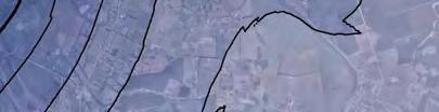
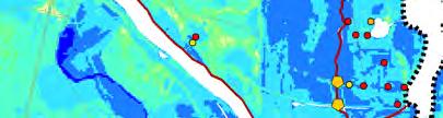
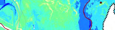
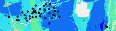
2 C1. Introduction For the purpose of this study, the objective has been to generate a water table surface for the earthquakes listed below. The earthquake-specific water table surfaces are used for the purpose of liquefaction vulnerability modelling. The four earthquake specific water table surfaces are: 1. The water table surface immediately prior to the 04 September 2010 earthquake; 2. The groundwater surface immediately prior to the 22 February 2011 earthquake; 3. The groundwater surface immediately prior to the 13 June 2011 earthquake; 4. The groundwater surface immediately prior to the 23 December 2011 earthquake. C2. Report on development of median water table surface The four earthquake-specific GW surfaces have been developed based on the median water table surface which was created for Christchurch, as summarised in the following report: van Ballegooy, S., Cox, S. C., Agnihotri, R., Reynolds, T., Thurlow, C., Rutter, H. K., Scott, D.M. Begg, J. G., McCahon, I. (2013) Median water table elevation in Christchurch and surrounding area after the 4 September 2010 Darfield Earthquake. GNS Science Report 2013/01 (in final draft at time of issue) The report presented contour maps of the water table elevation and depth below ground across Christchurch City and the surrounding area for the period following the M w 7.1 Darfield Earthquake of 04 September It also assessed the historic long-term (pre- Darfield Earthquake) fluctuations in the water table and compared them to the developed post-earthquake median water table surface, commenting on direct effects caused by the earthquake series. The median water table surface was generated using monitoring well data, as well as river monitoring and coastline data. The data was taken from the 'post-darfield Earthquake' period (04 September 2010 to 31 December 2012). Monitoring well data from the following sources contributed to the development of the median water table surface: 1. Christchurch City Council (CCC) 22 wells, long term (>10 year) monitoring duration, typically measured at weekly or fortnightly intervals; 2. Environment Canterbury (ECan) 22 wells, long term (>10 year) monitoring duration, typically measured at weekly or fortnightly intervals; 3. Earthquake Commission (EQC) 762 wells, all installed after 22 February 2011, typically measured at monthly intervals. The total 806 monitoring wells selected for the development of the median water table surface are assumed to provide data on the unconfined water table (as opposed to confined aquifers). To qualify as being representative of the surface water table, all monitoring wells were required to be either: 1. a shallow depth (<10 m) in the Eastern/Coastal or Transitional zones, with groundwater levels that are not locally anomalous; or 2. an intermediate depth (from <10 to 35 m) in the Inland Zone, west of Christchurch City where the groundwater is unconfined and Weeber (2008) demonstrated connection between the shallow aquifers. Any monitoring well records that appeared to be measuring confined groundwater levels, indicating either artesian or sub-artesian pressure, were not included in the dataset used to generate the median water table surface.
3 In addition to monitoring well data, monitored river level data for the Avon, Heathcote and Styx Rivers (provided by CCC), and river level data for the Waimakariri River (provided by ECan) contributed to the development of the median water table surface. Duration of monitoring data for the rivers varied from 15-minute to 6-hourly intervals. A mean sea level along sections of coastline on the study area s eastern extent was also assumed for the generation of the median water table surface. Two key resulting contour plots, which appear in the median water table report (van Ballegooy et al., 2013), are presented in this Appendix. The final contour plot of the median water table surface (m RL) is presented in Figure C.1. The contour plot showing the median depth to the water table surface (m bgl) is presented in Figure C.2. C3. Methodology for calculation of earthquake-specific water table surfaces The earthquake-specific contours were produced using data from the same sources as used in the median water table surface report (Section C2 above), except only those sources were used which had recorded water table levels immediately prior to the specific earthquake. The number of applicable monitoring wells with readings prior to each earthquake are summarised in the table below. Table C1: Monitoring data sources used for earthquake-specific water table surfaces EQC monitoring wells ECan monitoring wells CCC monitoring wells CCC river levels (Avon, Heathcote & Styx Rivers) 04 September February June December 2011 Note 1: It has been assumed that there is less than minor difference between groundwater levels for July 2011 and June 2011, therefore the water table levels recorded within the EQC monitored wells for July 2011 have assumed to be the likely water table levels just prior to the 13 June 2011 earthquake. The majority of the first phase of EQC monitoring wells were installed by the end of July 2011, after three of the four main earthquakes had occurred. While this means that by 23 December 2011 there were the most monitoring wells in place (which would theoretically result in the groundwater model with the highest level of confidence), due to the Christmas holiday period only around half of the monitoring wells were measured. As a result the 13 June 2011 groundwater surface has the highest level of confidence followed
4 by the December 2011 surface. The surface with the lowest confidence is the 04 September Where groundwater levels were available just prior to a specific earthquake the difference between the monthly groundwater reordering and the known median groundwater level (van Ballegooy et al., 2013) for that particular monitoring well was calculated. These differences were then used to create an earthquake-specific offset surface using Surfer kriging software. The offset contour represents a prediction of how water table levels at a particular month differ from the median groundwater levels (calculated over a 1-year or 2- year period) based on their location within the Christchurch area. Table C1 above provides details on the number of monitoring well points which contribute to each earthquake offset surface. Once the offset surface was produced it was visually inspected to identify any features which appear as anomalies relative to the other data points due to potential incorrect water table measurements, unusual seasonally high or low readings or other errors in the data. Where anomalies were identified the particular well was inspected and removed from the dataset (if required). Typically the initial offset plots produced for 13 June 2011 and 23 December 2011 had a good spread of data over the subject area and required little refinement before they could be used to create earthquake-specific water table levels. However the initial offset surfaces produced for 04 September 2010 and 22 February 2011 had a far less intensive spread of data over the subject area requiring further refinement before it could be used to create earthquake specific water table levels. Therefore, r river level monitoring stations were included to provide some control in the Avon River/CBD area. Using the same approach as for the monitoring wells, the difference between the median water level at a river station and the water level at the river station a day before the earthquake was used in creating the offset plot. After completing the earthquake-specific offset surface, Surfer s residual function was used to obtain an offset value for the monitoring wells which do not have a water table reading directly prior to the specific earthquake. The offset values were applied to the median water table levels (van Ballegooy et al., 2013) for each monitoring well to obtain an estimate of the earthquake-specific water table levels for well locations where no data was available for that specific earthquake. For further details on using the offset plot method for predicting water table levels reference should be made to van Ballegooy et al., 2013 Section 6. Once the earthquake-specific grid and contours were produced (as a surface in m RL) they were visually inspected to identify discrete points which caused features that did not fit with the overall surface and did not have sufficient data to justify the overall trend. Where necessary, well locations were deleted from the earthquake-specific water table surface if the particular well created features that could not be justified. In addition, a comparison between the earthquake-specific water table surface and LiDAR survey was undertaken to identify areas where water levels were above ground level. In these areas an individual groundwater drawdown point was added, with a water level set at 100mm below ground level. Up to 23 drawdown points were used in each of the four earthquake-specific surfaces. The following figures in this Appendix present the earthquake-specific water table surfaces which have been calculated:
5 The earthquake-specific contour plots of the water table surface (as a reduce level) for 04 September 2010, 22 February 2011, 13 June 2011 and 23 December 2011 are presented in Figures C3, C5, C7 and C9 respectively. The earthquake-specific contour plots showing the depth to the median water table surface (as metres below ground level) for 04 September 2010, 22 February 2011, 13 June 2011 and 23 December 2011 are presented in Figures C4, C6, C8 and C10 respectively.
6
7
8
9
10
11
12

13
14
15
The LSN Calculation and Interpolation Process
 Appendix I : The LSN Calculation and Interpolation Process I1. Introduction Cone Penetration Tests (CPTs) can be used in the assessment of the liquefaction vulnerability. The CPTs available from the Canterbury
Consideration of Ground Variability Over an Area of Geological Similarity as Part of Liquefaction Assessment for Foundation Design
 6 th International Conference on Earthquake Geotechnical Engineering 1-4 November 2015 Christchurch, New Zealand Consideration of Ground Variability Over an Area of Geological Similarity as Part of Liquefaction
Earthquake Commission Darfield Earthquake Recovery Geotechnical Factual Report New Brighton
 REPORT Earthquake Commission Darfield Earthquake Recovery Geotechnical Factual Report New Brighton REPORT Earthquake Commission Darfield Earthquake Recovery Geotechnical Factual Report New Brighton Report
Increased Liquefaction Vulnerability (ILV) Engineering Assessment
 Engineering Assessment") Increased Liquefaction Vulnerability (ILV) Engineering Assessment Increased Liquefaction Vulnerability (ILV) Engineering Assessment 2 Property details Property address 17 SAMPLE STREET, SAMPLEVILLE, CHRISTCHURCH,
Increased Liquefaction Vulnerability (ILV) Engineering Assessment Increased Liquefaction Vulnerability (ILV) Engineering Assessment 2 Property details Property address 17 SAMPLE STREET, SAMPLEVILLE, CHRISTCHURCH,
5 Information used for the ILV Assessment
 43 5 Information used for the ILV Assessment 5.1 Purpose and Outline In this section of the report the sources of information used in the ILV Assessment Methodology are described. The sources of information
3.4 Typical Soil Profiles
 SEI.UoC.0002.11 Figure 4. Streams in central Christchurch as mapped in March 1850, superposed on aerial photography captured on 24 February 2011. Streams digitised from the Black Map of Christchurch (March
Liquefaction induced ground damage in the Canterbury earthquakes: predictions vs. reality
 Bowen, H. J. & Jacka, M. E. () Proc. th NZGS Geotechnical Symposium. Ed. CY Chin, Queenstown Liquefaction induced ground damage in the Canterbury earthquakes: predictions vs. reality H J Bowen & M E Jacka
APPENDIX B APPENDIX B. Map series
 APPENDIX B APPENDIX B Map series EARTHQUAKE COMMISSION: Canterbury Earthquakes 21 and 211 - Land report as at 29 February 212 28 Map series Map series 1 - Overview maps Map 1.1 General overview map Map
LSN a new methodology for characterising the effects of liquefaction in terms of relative land damage severity
 van Ballegooy, S., Lacrosse, V., Jacka, M. & Malan, P. (2013) Proc. 19 th NZGS Geotechnical Symposium. Ed. CY Chin, Queenstown LSN a new methodology for characterising the effects of liquefaction in terms
Area-wide geotechnical information summary for CERA zoning review panel
 Area-wide geotechnical information summary for CERA zoning review panel This document contains all the area-wide geotechnical information which was considered by CERA as part of the process for making
Area-wide geotechnical information summary for CERA zoning review panel
 Area-wide geotechnical information summary for CERA zoning review panel This document contains all the area-wide geotechnical information which was considered by CERA as part of the process for making
Foundations on Deep Alluvial Soils
 Canterbury Earthquakes Royal Commission Hearings 25 October 2011, Christchurch GEO.CUB.0001.1-35.1 Foundations on Deep Alluvial Soils Misko Cubrinovski, Ian McCahon, Civil and Natural Resources Engineering,
10 Stage 2 Assessments
 119 10 Stage 2 Assessments 10.1 Purpose and Outline Each of the 6,700 residential properties in Christchurch identified as requiring further review following the Stage 1 qualification process were assessed
The Effect of Sea Level Rise on Liquefaction Vulnerability
 6 th International Conference on Earthquake Geotechnical Engineering 1-4 November 2015 Christchurch, New Zealand The Effect of Sea Level Rise on Liquefaction Vulnerability P. W. Quilter 1, S. van Ballegooy
Area-wide geotechnical information summary for CERA zoning review panel
 Area-wide geotechnical information summary for CERA zoning review panel This document contains all the area-wide geotechnical information which was considered by CERA as part of the process for making
Comparison between predicted liquefaction induced settlement and ground damage observed from the Canterbury earthquake sequence
 Power, P.M. & Jacka, M. (2013) the Canterbury earthquake sequence Proc. 19 th NZGS Geotechnical Symposium. Ed. CY Chin, Queenstown Comparison between predicted liquefaction induced settlement and ground
The Impact of the 2010 Darfield (Canterbury) Earthquake on the Geodetic Infrastructure in New Zealand 1
 Earthquake on the Geodetic Infrastructure in New Zealand 1") The Impact of the 2010 Darfield (Canterbury) Earthquake on the Geodetic Infrastructure in New Zealand 1 Graeme BLICK, John BEAVAN, Chris CROOK, Nic DONNELLY Keywords: Darfield Earthquake, control, survey,
The Impact of the 2010 Darfield (Canterbury) Earthquake on the Geodetic Infrastructure in New Zealand 1 Graeme BLICK, John BEAVAN, Chris CROOK, Nic DONNELLY Keywords: Darfield Earthquake, control, survey,
Redcliffs Park Coastal inundation and coastal erosion
 48 Hereford Street Christchurch 8013 Attention: Deb Taylor Dear Deb 1 Introduction The (MoE) are looking to relocate Redcliffs School to a new school development at and are currently undertaking their
Hawke s Bay Liquefaction Hazard Report - Frequently Asked Questions
 Hawke s Bay Liquefaction Hazard Report - Frequently Asked Questions What is liquefaction? Liquefaction occurs when an earthquake shakes up water-logged sediments. As a result, the soil behaves like a liquid
Area-wide geotechnical information summary for CERA zoning review panel
 Area-wide geotechnical information summary for CERA zoning review panel This document contains all the area-wide geotechnical information which was considered by CERA as part of the process for making
Analysis of Liquefaction-Induced Lateral Spreading Data from the 2010 Darfield and 2011 Christchurch Earthquakes
 Analysis of Liquefaction-Induced Lateral Spreading Data from the 2010 Darfield and 2011 Christchurch Earthquakes K. Robinson, B. A. Bradley, & M. Cubrinovski University of Canterbury, Christchurch, New
PLANNED UPGRADE OF NIWA S HIGH INTENSITY RAINFALL DESIGN SYSTEM (HIRDS)
") PLANNED UPGRADE OF NIWA S HIGH INTENSITY RAINFALL DESIGN SYSTEM (HIRDS) G.A. Horrell, C.P. Pearson National Institute of Water and Atmospheric Research (NIWA), Christchurch, New Zealand ABSTRACT Statistics
PLANNED UPGRADE OF NIWA S HIGH INTENSITY RAINFALL DESIGN SYSTEM (HIRDS) G.A. Horrell, C.P. Pearson National Institute of Water and Atmospheric Research (NIWA), Christchurch, New Zealand ABSTRACT Statistics
Canterbury Earthquake Sequence: Increased Liquefaction Vulnerability Assessment Methodology
 Canterbury Earthquake Sequence: Increased Liquefaction Vulnerability Assessment Methodology Prepared for Chapman Tripp acting on behalf of the Earthquake Commission (EQC) Prepared by Date Job Number 52010.140.v1.0
Earthquake Commission. Darfield Earthquake Recovery Geotechnical Factual Report Avondale
 REPORT Earthquake Commission Darfield Earthquake Recovery Geotechnical Factual Report Avondale REPORT Earthquake Commission Darfield Earthquake Recovery Geotechnical Factual Report Avondale Report prepared
SHAKING AND GROUND FAILURE-INDUCED DAMAGE TO BUILDINGS BY THE 2010 AND 2011 CHRISTCHURCH EARTHQUAKES AND ITS LESSONS
 Int. Journal for Housing Science, Vol.36, No.3 pp.162-169, 2012 Published in the United States SHAKING AND GROUND FAILURE-INDUCED DAMAGE TO BUILDINGS BY THE 2010 AND 2011 CHRISTCHURCH EARTHQUAKES AND ITS
GUIDANCE D. Part D: Guidelines for the geotechnical investigation and assessment of subdivisions in the Canterbury region.
 GUIDANCE D CONTENTS Part D: Guidelines for the geotechnical investigation and assessment of subdivisions in the Canterbury region Minimum requirements for geotechnical assessment for land development (
Wainui Beach Management Strategy (WBMS) Summary of Existing Documents. GNS Tsunami Reports
 Summary of Existing Documents. GNS Tsunami Reports") Wainui Beach Management Strategy (WBMS) Summary of Existing Documents GNS Tsunami Reports a) Review of Tsunami Hazard and Risk in New Zealand ( National Risk Report ) b) Review of New Zealand s Preparedness
Wainui Beach Management Strategy (WBMS) Summary of Existing Documents GNS Tsunami Reports a) Review of Tsunami Hazard and Risk in New Zealand ( National Risk Report ) b) Review of New Zealand s Preparedness
Christchurch CBD: Lessons Learnt and Strategies for Foundation Remediation 22 February 2011 Christchurch, New Zealand, Earthquake
 Christchurch CBD: Lessons Learnt and Strategies for Foundation Remediation 22 February 2011 Christchurch, New Zealand, Earthquake K.M. Murahidy & A.F. Sleight Tonkin & Taylor Ltd, Christchurch, New Zealand
Slide 1: Earthquake sequence (with colour coding around big events and subsequent period). Illustrates migration to the east initially into
. Illustrates migration to the east initially into") Slide 1: Earthquake sequence (with colour coding around big events and subsequent period). Illustrates migration to the east initially into Christchurch, but now moving away (23 December in particular).
Slide 1: Earthquake sequence (with colour coding around big events and subsequent period). Illustrates migration to the east initially into Christchurch, but now moving away (23 December in particular).
Reliability of lateral stretch estimates in Canterbury earthquakes
 Reliability of lateral stretch estimates in 2010-2011 Canterbury earthquakes Proc. 19 th NZGS Geotechnical Symposium. Ed. CY Chin, Queenstown Reliability of lateral stretch estimates in 2010-2011 Canterbury
Coastal Hazard and Climate-Change Risk Exposure in New Zealand: Comparing Regions and Urban Areas
 Presented at the FIG Working Week 2016, May 2-6, 2016 in Christchurch, New Zealand Coastal Hazard and Climate-Change Risk Exposure in New Zealand: Comparing Regions and Urban Areas Rob Bell, Ryan Paulik
A high-resolution shear wave velocity model for near surface soils in Christchurch using CPT data
 A high-resolution shear wave velocity model for near surface soils in Christchurch using CPT data C.R. McGann Washington State University, Pullman, Washington, USA B.A. Bradley, M. Cubrinovski University
WHITE POINT LANDSLIDE GEOTECHNICAL INVESTIGATION November 29, 2012 Status Report
 Gary Lee Moore, P.E., City Engineer Vince Jones, P.E., Deputy City Engineer WHITE POINT LANDSLIDE GEOTECHNICAL INVESTIGATION November 29, 2012 Status Report White Point Landslide Geotechnical Investigation
Mozambique. General Climate. UNDP Climate Change Country Profiles. C. McSweeney 1, M. New 1,2 and G. Lizcano 1
 UNDP Climate Change Country Profiles Mozambique C. McSweeney 1, M. New 1,2 and G. Lizcano 1 1. School of Geography and Environment, University of Oxford. 2.Tyndall Centre for Climate Change Research http://country-profiles.geog.ox.ac.uk
14 Geotechnical Hazards
 Volume 2: Assessment of Environmental Effects 296 14 Geotechnical Hazards Overview This Chapter provides an assessment of the underlying geotechnical conditions to identify: any potential liquefaction
Determine the trend for time series data
 Extra Online Questions Determine the trend for time series data Covers AS 90641 (Statistics and Modelling 3.1) Scholarship Statistics and Modelling Chapter 1 Essent ial exam notes Time series 1. The value
Tonkin & Taylor Christchurch Central City Geological Interpretative Report
 Tonkin & Taylor Christchurch City Council Report Disclaimer The information contained in this report represents the current view of Tonkin & Taylor which is subject to change (in whole or in part) without
Illinois Drought Update, December 1, 2005 DROUGHT RESPONSE TASK FORCE Illinois State Water Survey, Department of Natural Resources
 Illinois Drought Update, December 1, 2005 DROUGHT RESPONSE TASK FORCE Illinois State Water Survey, Department of Natural Resources For more drought information please go to http://www.sws.uiuc.edu/. SUMMARY.
Comparison of liquefaction-induced land damage and geomorphic variability in Avonside, New Zealand
 6 th International Conference on Earthquake Geotechnical Engineering 1-4 November 2015 Christchurch, New Zealand Comparison of liquefaction-induced land damage and geomorphic variability in Avonside, New
High intensity rainfall estimation in New Zealand
 Water New Zealand 31 st October 2013 High intensity rainfall estimation in New Zealand Graeme Horrell Engineering Hydrologist, Contents High Intensity Rainfall Design System (HIRDS Version 1) HIRDS Version
Appin Colliery - Longwall 705
 REPORT: END OF PANEL SUBSIDENCE MONITORING REPORT BHP BILLITON ILLAWARRA COAL: Appin Colliery - Longwall 705 End of Panel Subsidence Monitoring Report for Appin Longwall 705 MSEC JUNE 2014 REPORT NUMBER:
DISCLAIMER. The data presented in this Report are available to GNS Science for other use from April BIBLIOGRAPHIC REFERENCE
 DISCLAIMER This report has been prepared by the Institute of Geological and Nuclear Sciences Limited (GNS Science) exclusively for and under contract to the Canterbury Earthquake Recovery Authority and
February 10, Mr. Jeff Smith, Chairman Imperial Valley Water Authority E County Road 1000 N Easton, IL Dear Chairman Smith:
 February 1, 1 Mr. Jeff Smith, Chairman Imperial Valley Water Authority 8 E County Road 1 N Easton, IL Dear Chairman Smith: The Illinois State Water Survey (ISWS), under contract to the Imperial Valley
Assessment of liquefaction risk in the Hawke's Bay Volume 1: The liquefaction hazard model
 Assessment of liquefaction risk in the Hawke's Bay Volume 1: The liquefaction hazard model BJ Rosser and S Dellow (compilers) GNS Science Consultancy Report 2015/186 October 2017 DISCLAIMER This report
GROUND MOTION MAPS BASED ON RECORDED MOTIONS FOR THE EARTHQUAKES IN THE CANTERBURY EARTHQUAKE SEQUENCE
 GROUND MOTION MAPS BASED ON RECORDED MOTIONS FOR THE EARTHQUAKES IN THE CANTERBURY EARTHQUAKE SEQUENCE Robert Buxton 1, Graeme McVerry 2, Tatiana Goded 3 ABSTRACT: There has been a demand for maps of estimated
St Lucia. General Climate. Recent Climate Trends. UNDP Climate Change Country Profiles. Temperature. Precipitation
 UNDP Climate Change Country Profiles St Lucia C. McSweeney 1, M. New 1,2 and G. Lizcano 1 1. School of Geography and Environment, University of Oxford. 2. Tyndall Centre for Climate Change Research http://country-profiles.geog.ox.ac.uk
RAINFALL AVERAGES AND SELECTED EXTREMES FOR CENTRAL AND SOUTH FLORIDA. Thomas K. MacVicar
 TECHNICAL PUBLICATION #83-2 March 1983 RAINFALL AVERAGES AND SELECTED EXTREMES FOR CENTRAL AND SOUTH FLORIDA by Thomas K. MacVicar "This public document was promulgated at an annual cost of $136.74, or
Malawi. General Climate. UNDP Climate Change Country Profiles. C. McSweeney 1, M. New 1,2 and G. Lizcano 1
 UNDP Climate Change Country Profiles Malawi C. McSweeney 1, M. New 1,2 and G. Lizcano 1 1. School of Geography and Environment, University of Oxford. 2. Tyndall Centre for Climate Change Research http://country-profiles.geog.ox.ac.uk
Grenada. General Climate. Recent Climate Trends. UNDP Climate Change Country Profiles. Temperature. Precipitation
 UNDP Climate Change Country Profiles C. McSweeney 1, M. New 1,2 and G. Lizcano 1 1. School of Geography and Environment, University of Oxford. 2. Tyndall Centre for Climate Change Research http://country-profiles.geog.ox.ac.uk
New Zealand Climate Update No 223, January 2018 Current climate December 2017
 New Zealand Climate Update No 223, January 2018 Current climate December 2017 December 2017 was characterised by higher than normal sea level pressure over New Zealand and the surrounding seas. This pressure
REPORT STAGE 1 REPORT. Earthquake Commission. Darfield Earthquake 4 September 2010 Geotechnical Land Damage Assessment & Reinstatement Report
 REPORT Earthquake Commission Geotechnical Land Damage Assessment & Reinstatement Report STAGE 1 REPORT Prepared by Tonkin & Taylor Limited for the Earthquake Commission October 2010 Applicability This
Worked Examples Assessment of foundation solutions for residential technical category 3 properties
 Worked Examples Assessment of foundation solutions for residential technical category 3 properties These worked examples are to accompany revised Section 15.3 and Appendix C4 of MBIE Guidance for repairing
Forms of Flat Land Damage
 Appendix B : Forms of Flat Land Damage Table B1.1 EQC Land Damage Categories for the Flat Land Areas in Christchurch Figure B1.1 - Maps of the liquefaction related land damage for the four main earthquake
Project Appraisal Guidelines
 Project Appraisal Guidelines Unit 16.2 Expansion Factors for Short Period Traffic Counts August 2012 Project Appraisal Guidelines Unit 16.2 Expansion Factors for Short Period Traffic Counts Version Date
Ongoing development of a 3D seismic velocity model of Canterbury, New Zealand for broadband ground motion simulation
 Ongoing development of a 3D seismic velocity model of Canterbury, New Zealand for broadband ground motion simulation R.L Lee, B.A. Bradley, J.R. Pettinga & M.W. Hughes University of Canterbury, New Zealand.
Macro and micro scale assessment and quantification of Ground damage following the Canterbury 2010/2011 Earthquake sequence
 Macro and micro scale assessment and quantification of Ground damage following the Canterbury 2010/2011 Earthquake sequence S.C. Wallace & A.J. Macdonald Tonkin & Taylor Ltd. 33 Parkhouse Road, PO Box
Supplementary appendix
 Supplementary appendix This appendix formed part of the original submission and has been peer reviewed. We post it as supplied by the authors. Supplement to: Lowe R, Stewart-Ibarra AM, Petrova D, et al.
Recovery Analysis Methods and Data Requirements Study
 Elevation Recovery Analysis Methods and Data Requirements Study Update to NTB Phase II Local Technical Peer Review Group December 3, 2003 Time 1 Schedule for Pumpage Reductions 180 160 140 120 158 121
A Method of Quantifying Noble Gas Releases Douglas Wahl Exelon Limerick Generating Station
 A Method of Quantifying Noble Gas Releases Douglas Wahl Exelon Limerick Generating Station The Plant Technical Specifications through the ODCM require monitoring of the ventilation systems for radioactive
Developments in geotechnical site investigations in Christchurch following the Canterbury earthquake sequence
 Neeson, F.C. (2013) Developments in geotechnical site investigations in Christchurch following the Canterbury earthquake sequence Proc. 19 th NZGS Geotechnical Symposium. Ed. CY Chin, Queenstown Developments
2010 PERTH STORM 2010 MELBOURNE STORM
 2011 TOHOKU EARTHQUAKE 2010 PAKISTAN FLOODS 2010 CHINA FLOODS 2011 CYCLONE YASI 2010/2011 QUEENSLAND FLOODS 2010 PERTH STORM 2011 VICTORIA FLOOD 2010 MELBOURNE STORM 2010 DARFIELD EARTHQUAKE 2011 LYTTELTON
Chiang Rai Province CC Threat overview AAS1109 Mekong ARCC
 Chiang Rai Province CC Threat overview AAS1109 Mekong ARCC This threat overview relies on projections of future climate change in the Mekong Basin for the period 2045-2069 compared to a baseline of 1980-2005.
Updating of the Three-dimensional Hydrogeological Model of the Virttaankangas Area, Southwestern Finland
 Updating of the Three-dimensional Hydrogeological Model of the Virttaankangas Area, Southwestern Finland Saraperä S. 1, Artimo A. 2, 1 Department of Geology, FIN-20014, University of Turku, Finland, 2
Rapid Earthquake Loss Assessment: Stochastic Modelling and an Example of Cyclic Fatigue Damage from Christchurch, New Zealand
 Rapid Earthquake Loss Assessment: Stochastic Modelling and an Example of Cyclic Fatigue Damage from Christchurch, New Zealand John B. Mander 1 and Geoffrey W. Rodgers 2, David Whittaker 3 1 University
Performance and Post Earthquake Assessment of CFA Pile Ground Improvement 22 February 2011 Christchurch, New Zealand Earthquake
 Performance and Post Earthquake Assessment of CFA Pile Ground Improvement 22 February 2011 Christchurch, New Zealand Earthquake K. M. Murahidy, S. W Sutherland & M. E. Jacka Tonkin & Taylor Ltd, Christchurch,
Magnitude 6.3 SOUTH ISLAND OF NEW ZEALAND
 A magnitude 6.3 earthquake shook the southern New Zealand city of Christchurch. At least 100 people are reported dead, and there are reports of collapsed buildings, cracked streets and flooding due to
SUPPLEMENTARY INFORMATION
 SUPPLEMENTARY INFORMATION Fortnightly atmospheric tides forced by spring and neap tides in coastal waters Shinsuke Iwasaki 1, Atsuhiko Isobe 1 and Yasuyuki Miyao 2 1 Research Institute for Applied Mechanics,
General Editor: Vince Russett
 YCCCART 2014/Y20 North Somerset HER 2015/11 Manual survey using an electronic, hydryostatic level (NIVCOMP) at Wemberham Roman Villa YATTON, CONGRESBURY, CLAVERHAM AND CLEEVE ARCHAEOLOGICAL RESEARCH TEAM
ENGINEER S CERTIFICATION OF FAULT AREA DEMONSTRATION (40 CFR )
") PLATTE RIVER POWER AUTHORITY RAWHIDE ENERGY STATION BOTTOM ASH TRANSFER (BAT) IMPOUNDMENTS LARIMER COUNTY, CO ENGINEER S CERTIFICATION OF FAULT AREA DEMONSTRATION (40 CFR 257.62) FOR COAL COMBUSTION RESIDUALS
PLATTE RIVER POWER AUTHORITY RAWHIDE ENERGY STATION BOTTOM ASH TRANSFER (BAT) IMPOUNDMENTS LARIMER COUNTY, CO ENGINEER S CERTIFICATION OF FAULT AREA DEMONSTRATION (40 CFR 257.62) FOR COAL COMBUSTION RESIDUALS
National Report of New Zealand
 National Report of New Zealand Prepared for GLOSS Training Course Tokyo May 2006 Glen Rowe Data Analyst Hydrographic Services Land Information New Zealand National Office 160 Lambton Quay Wellington New
Application and verification of ECMWF products 2015
 Application and verification of ECMWF products 2015 Instituto Português do Mar e da Atmosfera, I.P. 1. Summary of major highlights At Instituto Português do Mar e da Atmosfera (IPMA) ECMWF products are
Preliminary report on the Canterbury Earthquake South Island of New Zealand , M 6.3
 Preliminary report on the Canterbury Earthquake South Island of New Zealand 21.02.2011, M 6.3 Kyriazis Pitilakis and the group of - Aristotle University Thessaloniki, Greece. General 2 General 147 people
Tool 2.1.4: Inundation modelling of present day and future floods
 Impacts of Climate Change on Urban Infrastructure & the Built Environment A Toolbox Tool 2.1.4: Inundation modelling of present day and future floods Authors M. Duncan 1 and G. Smart 1 Affiliation 1 NIWA,
Imaging Unknown Faults in Christchurch, New Zealand, after a M6.2 Earthquake
 Imaging Unknown Faults in Christchurch, New Zealand, after a M6.2 Earthquake D.C. Lawton* (University of Calgary), M.B. Bertram (University of Calgary), K.W. Hall (University of Calgary), K.L. Bertram
Multi-scale evaluations of submarine groundwater discharge
 doi:10.5194/piahs-365-66-2015 66 Complex Interfaces Under Change: Sea River Groundwater Lake Proceedings of HP2/HP3, IAHS-IAPSO-IASPEI Assembly, Gothenburg, Sweden, July 2013 (IAHS Publ. 365, 2014). Multi-scale
Jocelyn Karen Campbell
 THE UNCERTAINTIES IN ASSESSING THE IMPACT OF REGIONAL SEISMICITY AT THE WIL SITE Statement of Evidence by Jocelyn Karen Campbell A CANTERBURY FAULTS coded by type CHARACTERISTICS OF THRUST FAULTS IN CANTERBURY
GIS modelling in support of earthquake-induced rockfall risk assessment in the Port Hills, Christchurch
 GIS modelling in support of earthquake-induced rockfall risk assessment in the Port Hills, Christchurch Biljana Lukovic, David Heron, William Ries & Chris Massey Natural Hazards Division GNS Science, Lower
Appendix J Vegetation Change Analysis Methodology
 Appendix J Vegetation Change Analysis Methodology Regional Groundwater Storage and Recovery Project Draft EIR Appendix-J April 2013 APPENDIX J- LAKE MERCED VEGETATION CHANGE ANALYSIS METHODOLOGY Building
CSO Post-Construction Monitoring and Performance Assessment
 Massachusetts Water Resources Authority CSO Post-Construction Monitoring and Performance Assessment Jeremy R. Hall, Project Manager Operations/Engineering & Construction Wastewater Advisory Committee December
ZUMWALT WEATHER AND CLIMATE ANNUAL REPORT ( )
") ZUMWALT WEATHER AND CLIMATE ANNUAL REPORT (26-29) FINAL DRAFT (9 AUGUST 21) J.D. HANSEN 1, R.V. TAYLOR 2, AND V.S. JANSEN 3 INTRODUCTION The Zumwalt Prairie in northeastern Oregon is a unique grassland
ZUMWALT WEATHER AND CLIMATE ANNUAL REPORT (26-29) FINAL DRAFT (9 AUGUST 21) J.D. HANSEN 1, R.V. TAYLOR 2, AND V.S. JANSEN 3 INTRODUCTION The Zumwalt Prairie in northeastern Oregon is a unique grassland
Rosemerryn Subdivision, Lincoln Stages 10 to 18 Geotechnical Investigation Report Fulton Hogan Land Development Limited
 This information Memorandum, title or other supplementary property information (the Information ) has been prepared by Whalan and Partners Limited, trading as Bayleys ( Bayleys ) as agent for the Vendor.
Technical Memorandum. City of Salem, Stormwater Management Design Standards. Project No:
 Technical Memorandum 6500 SW Macadam Avenue, Suite 200 Portland, Oregon, 97239 Tel: 503-244-7005 Fax: 503-244-9095 Prepared for: Project Title: City of Salem, Oregon City of Salem, Stormwater Management
Graphing Sea Ice Extent in the Arctic and Antarctic
 Graphing Sea Ice Extent in the Arctic and Antarctic 1. Large amounts of ice form in some seasons in the oceans near the North Pole and the South Pole (the Arctic Ocean and the Southern Ocean). This ice,
REPORT. Ngai Tahu Property Ltd. Wigram Skies Subdivision Geotechnical Assessment
 REPORT Ngai Tahu Property Ltd Wigram Skies Subdivision Geotechnical Assessment REPORT Ngai Tahu Property Ltd Wigram Skies Subdivision Geotechnical Assessment Report prepared for: Ngai Tahu Property Ltd
The key natural hazards relevant to the Project area relate to seismic activity and flood risk.
 21. NATURAL HAZARDS Overview The key natural hazards relevant to the Project area relate to seismic activity and flood risk. Seismic activity, including ground shaking and liquefaction, is a significant
Project No India Basin Shadow Study San Francisco, California, USA
 Project No. 432301 India Basin Shadow Study San Francisco, California, USA Numerical Modelling Studies 04 th June 2018 For Build Inc. Report Title: India Basin Shadow Study San Francisco, California, USA
REPORT. Earthquake Commission. Christchurch Earthquake Recovery Geotechnical Factual Report Hillsborough Appendix B: Cone Penetration Testing
 REPORT Earthquake Commission Christchurch Earthquake Recovery Geotechnical Factual Report Hillsborough Appendix B: Cone Penetration Testing REPORT Earthquake Commission Christchurch Earthquake Recovery
Rainfall Observations in the Loxahatchee River Watershed
 Rainfall Observations in the Loxahatchee River Watershed Richard C. Dent Loxahatchee River District September 1997 Introduction Rain is a common occurrence in south Florida, yet its presence or absence
Geotechnical Completion Report Knights Stream Park Stage3A Development (Lots 107 to 148)
") Aurecon New Zealand Limited Unit 1, 150 Cavendish Road Casebrook Christchurch 8051 PO Box 1061 Christchurch 8140 New Zealand T F E W +64 3 366 0821 +64 3 379 6955 christchurch@aurecongroup.com aurecongroup.com
Aurecon New Zealand Limited Unit 1, 150 Cavendish Road Casebrook Christchurch 8051 PO Box 1061 Christchurch 8140 New Zealand T F E W +64 3 366 0821 +64 3 379 6955 christchurch@aurecongroup.com aurecongroup.com
Geophysical Surveys for Groundwater Modelling of Coastal Golf Courses
 1 Geophysical Surveys for Groundwater Modelling of Coastal Golf Courses C. RICHARD BATES and RUTH ROBINSON Sedimentary Systems Research Group, University of St. Andrews, St. Andrews, Scotland Abstract
Table 1 - Infiltration Rates
 Stantec Consulting Ltd. 100-300 Hagey Boulevard, Waterloo ON N2L 0A4 November 14, 2017 File: 161413228/10 Attention: Mr. Michael Witmer, BES, MPA, MCIP, RPP City of Guelph 1 Carden Street Guelph ON N1H
New Zealand Climate Update No 226, April 2018 Current climate March 2018
 New Zealand Climate Update No 226, April 2018 Current climate March 2018 March 2018 was characterised by significantly higher pressure than normal to the east of New Zealand. This pressure pattern, in
SUPPLEMENTARY INFORMATION
 doi:10.1038/nature12310 We present here two additional Tables (Table SI-1, 2) and eight further Figures (Figures SI-1 to SI-8) to provide extra background information to the main figures of the paper.
A summary of the weather year based on data from the Zumwalt weather station
 ZUMWALT PRAIRIE WEATHER 2016 A summary of the weather year based on data from the Zumwalt weather station Figure 1. An unusual summer storm on July 10, 2016 brought the second-largest precipitation day
Performance of the GSN station KONO-IU,
 Performance of the GSN station KONO-IU, 1991-2009 A report in a series documenting the status of the Global Seismographic Network WQC Report 2010:9 February 28, 2010 Göran Ekström and Meredith Nettles
Guidelines for Geotechnical Site Investigation for Residential Building Consents in Hastings District. (Draft)
") Guidelines for Geotechnical Site Investigation for Residential Building Consents in Hastings District (Draft) December 2017 Acknowledgements These guidelines have been prepared with assistance from Tonkin
Guidelines for Geotechnical Site Investigation for Residential Building Consents in Hastings District (Draft) December 2017 Acknowledgements These guidelines have been prepared with assistance from Tonkin
Spectra and Pgas for the Assessment and Reconstruction of Christchurch
 Spectra and Pgas for the Assessment and Reconstruction of Christchurch G.H. McVerry, M.C. Gerstenberger, D.A. Rhoades & M.W. Stirling GNS Science, Lower Hutt, New Zealand. 2012 NZSEE Conference ABSTRACT:
APPENDIX B PHYSICAL BASELINE STUDY: NORTHEAST BAFFIN BAY 1
 APPENDIX B PHYSICAL BASELINE STUDY: NORTHEAST BAFFIN BAY 1 1 By David B. Fissel, Mar Martínez de Saavedra Álvarez, and Randy C. Kerr, ASL Environmental Sciences Inc. (Feb. 2012) West Greenland Seismic
Coastal Hazard Assessment for Christchurch and Banks Peninsula (2017)
") Report Coastal Hazard Assessment for Christchurch and Banks Peninsula (2017) Prepared for Prepared by Date Job Number 851857.0040.v4 Distribution: Environment Canterbury (FILE) 1 copy + 1 digital 1 copy
Report Coastal Hazard Assessment for Christchurch and Banks Peninsula (2017) Prepared for Prepared by Date Job Number 851857.0040.v4 Distribution: Environment Canterbury (FILE) 1 copy + 1 digital 1 copy
A SUMMARY OF STRONG GROUND MOTIONS OBSERVED IN THE CANTERBURY EARTHQUAKE SEQUENCE
 New Zealand Japan Workshop on Soil Liquefaction during Recent Large-Scale Earthquakes December -, Paper No. ++++ A SUMMARY OF STRONG GROUND MOTIONS OBSERVED IN THE CANTERBURY EARTHQUAKE SEQUENCE Brendon