Preliminary report on the Canterbury Earthquake South Island of New Zealand , M 6.3
|
|
|
- Jane Warren
- 5 years ago
- Views:
Transcription
1 Preliminary report on the Canterbury Earthquake South Island of New Zealand , M 6.3 Kyriazis Pitilakis and the group of - Aristotle University Thessaloniki, Greece.
2 General 2

3 General 147 people have been confirmed dead and 50 not yet accounted for Center of city evacuated as aftershocks continue Phone network outage in many areas after the earthquake Vast areas where liquefaction took place 3
4 This earthquake was an aftershock of the September 2010 magnitude 7.0 earthquake, and one of hundreds of aftershocks Christchurch has experienced. However, unlike the September 2010 magnitude 7.0 earthquake, which struck early in the morning when streets were virtually empty, this earthquake struck just before 1 pm local time when the streets, shops and offices in Christchurch were full. source: 4
5 Christchurch is still rebuilding from the September 3, 2010 magnitude 7.0 earthquake that struck 45 km (30 miles) west of the city. That earthquake damaged hundreds of buildings in the city and caused an estimated $5 billion in damage. A strong aftershock in December further weakened buildings. The epicenter of the February 21, 2011 magnitude 6.3 earthquake was just 5 km (3 miles) from Christchurch. Because of proximity to the epicenter, ground shaking in Christchurch was much more severe for this latest earthquake than for the larger magnitude 7 event in September. source: 5
6 New Zealand Tectonics 6
7 Deep earthquakes the last ten years 7

8 Shallow earthquakes the last ten years 8

9 New Zealand tectonics 9

10 New Zealand tectonics 10
11 Seismological aspects 11
12 Earthquake Details Magnitude: 6.3 Date-Time: Monday, February 21, 2011 at 23:51:43 UTC Tuesday, February 22, 2011 at 12:51:43 PM at epicenter Location: S, E Depth: 5 km (3.1 miles) Region: SOUTH ISLAND OF NEW ZEALAND Distances : NEAR Christchurch, New Zealand 225 km (140 miles) SSE of Westport, New Zealand 305 km (190 miles) SSW of WELLINGTON, New Zealand 310 km (190 miles) NE of Dunedin, New Zealand Location Uncertainty : horizontal +/ km (7.6 miles); depth +/- 0.6 km (0.4 miles) Parameters: Nph= 0, Dmin=0 km, Rmss=0.98 sec, Gp= 0, M-type="moment" magnitude from initial P wave (tsuboi method) (Mi/Mwp), Version=D Source : Institute of Geological and Nuclear Sciences, Lower Hutt, New Zealand source: 12
13 Tectonic Summary The February 21, 2011 South Island, New Zealand earthquake occurred as part of the aftershock sequence of the M 7.0 September 3, 2010 Darfield, NZ earthquake. It involved oblique-thrust faulting at the easternmost limit of previous aftershocks, and like the mainshock itself is broadly associated with regional plate boundary deformation as the Pacific and Australia plates interact in the central South Island, New Zealand. This latest shock is significantly closer to the main population center of Christchurch, NZ, than is the September 2010 mainshock, in the vicinity of several other moderate (M 4 to 5) sized aftershocks located east of the main rupture zone of the 2010 event. Since the September 3, 2010 mainshock, there have been approximately 6 M>=5.0 aftershocks in the Christchurch region. The February 21st earthquake represents the largest aftershock to date, more that half a magnitude unit larger than the previous largest aftershock. source: 13


14 Earthquake location maps source: 14


15 Earthquake location maps source: 15

16 Intensity source: 16

17 Instrumental Intensity map source: 17

18 Peak Ground Acceleration source: 18
19 Peak Ground Velocity source: 19

20 Uncertainty source: 20
21 Spectral Response 0.3 sec Period 1 sec Period source: 21

22 Media Maps Decorated Bare source: 22

23 Earthquake Shaking Alert Level 23

24 Historical seismicity 24

25 Seismic hazard map 25

26 Earthquake Density Maps Average number of Earthquakes per Year per 12,300 km 2, Magnitude 5 and Greater Shallow Earthquakes: Depth 0-70 km 26

27 Earthquake Density Maps Average number of Earthquakes per Year per 12,300 km 2, Magnitude 5 and Greater All Depths 27

 derived from the estimated moment")

28 USGS Centroid Moment Solution USGS CENTROID MOMENT TENSOR 11/02/21 23:52:02.79 Centroid: Depth 10 No. of sta: 36 Moment Tensor; Scale 10**18 Nm Mrr= 1.11 Mtt= 0.58 Mpp=-1.69 Mrt= 0.20 Mrp=-0.40 Mtp=-1.23 Principal axes: T Val= 1.47 Plg=45 Azm= 28 N P Visual representation of the style of faulting (focal mechanism) derived from the estimated moment tensor. Shaded areas show quadrants of the focal sphere in which the P-wave firstmotions are away form the source, and unshaded areas show quadrants in which the P- wave first-motions are toward the source. Best Double Couple:Mo=1.9*10**18 NP1:Strike= 60 Dip=56 Slip= 148 NP2:

29 USGS WPhase Moment Tensor Solution USGS/WPHASE CENTROID MOMENT TENSOR 11/02/21 23:51:42.00 Centroid: Depth 15 No. of sta: 17 Moment Tensor; Scale 10**19 Nm Mrr= 0.06 Mtt= 0.06 Mpp=-0.12 Mrt= 0.05 Mrp=-0.05 Mtp=-0.10 Principal axes: T Val= 1.20 Plg=16 Azm= 64 N = P = Visual representation of the style of faulting (focal mechanism) derived from the estimated moment tensor. Shaded areas show quadrants of the focal sphere in which the P-wave firstmotions are away form the source, and unshaded areas show quadrants in which the P- wave first-motions are toward the source. Best Double Couple:Mo=0.2*10**19 NP1:Strike= 64 Dip=59 Slip= 156 NP2:

30 Historic USGS Moment Tensor Solutions 30
 wave from the earthquake location to points around the globe.")

31 Theoretical P-Wave Travel Times Predicted (theoretical) travel times, in minutes, of the compressional (P) wave from the earthquake location to points around the globe. The travel times are computed using the spherically-symmetric IASP91 reference earth velocity model. The heavy black lines shown are the approximate distances to the P- wave shadow zone (103 to 140 degrees). source: 31
32 Geotechnical Information 32

33 Geotechnical Information 33


34 Google Earth mapping service 2004 Christchurch city council evaluation of liquefaction potential hazard. (red maps high liquefaction potential) Christchurch faces an additional hazard of liquefaction that can result from earth shaking during an earthquake, and which occurred in significant portions of the city in the September, 2010 earthquake. source:
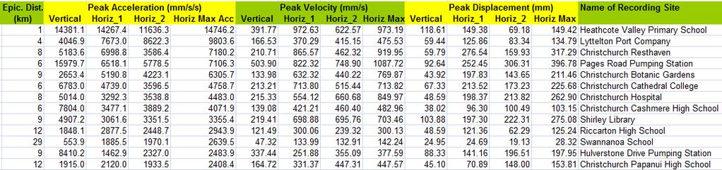
35 Strong Motion Records 35
36 Much higher PGA and PSA values than the previous earthquake (Sept. 2010, M=7.1) In a specific location (LPCC) the PHGA (T=0) is almost 1.0g! and the PHSA values at T= sec are of the order of 3.0g!!!

37 Recordings source: 37
38 Recordings 38
39 Recordings comparison with the September 2010 EQ The following data are preliminary ground motions at 5 locations in the area obtained from the Feb 22 M6.3 Ground motions are filtered with bandpass 50Hz and 0.05Hz The figure below shows the locations of the six ground motion records: CCCC: Christs College CHHC: Christchurch hospital LPCC: Lyttleton port SHLC: Shirley school SMTC: Styx Mill TPLC: Templeton Dr. Brendon Bradley source: 39
 Dr. Brendon Bradley source: http://db.nzsee.org.nz 40")
40 Recordings comparison with the September 2010 EQ The acceleration time histories have three figures (first two are horiz, third vert) The spectra are geometric mean (i.e. the geometric average of the two horiz components) Dr. Brendon Bradley source: 40
41 Recordings comparison with the September 2010 EQ Dr. Brendon Bradley source: 41

42 Recordings comparison with the September 2010 EQ Dr. Brendon Bradley source: 42
43 Recordings comparison with the September 2010 EQ Dr. Brendon Bradley source: 43

44 Recordings comparison with the September 2010 EQ Dr. Brendon Bradley source: 44
45 Recordings comparison with the September 2010 EQ Dr. Brendon Bradley source: 45

46 Recordings comparison with the September 2010 EQ Dr. Brendon Bradley source: 46
47 Recordings comparison with the September 2010 EQ Dr. Brendon Bradley source: 47

48 Recordings comparison with the September 2010 EQ Dr. Brendon Bradley source: 48
49 Recordings comparison with the September 2010 EQ Dr. Brendon Bradley source: 49

50 Recordings comparison with the September 2010 EQ Dr. Brendon Bradley source: 50
51 Recordings comparison with the September 2010 EQ Dr. Brendon Bradley source: 51
52 Recordings comparison with the September 2010 EQ The figures illustrate the following: Because of short source to site distance, the shaking in CCCC, CHHC, LPCC, SHLC was stronger than from the Darfield Mainshock. This is particularly at short vibration periods which the majority of building stock are. The shaking at Styx mill (SMTC) was similar to the Darfield mainshock Because of the small magnitude (i.e. source size), the shaking intensity is very localized, i.e. at Templeton (TPLC) the shaking is lower than the mainshock. Dr. Brendon Bradley source: 52
53 Structural damage 53

54 Earthquake topples Christchurch Cathedral's spire Earthquake topples Christchurch Cathedral's spire source: guardian.co.uk

55 Earthquake topples Christchurch Cathedral's spire source: 55

56 Cracks on structural elements source: 56

57 Cracks on structural elements source: 57

58 Total collapse of a building source: 58

59 Total collapse of a building source: 59

60 Total collapse of a building source: 60

61 Total collapse of a building source: 61

62 Total collapse of a building source: 62

63 Total collapse of a building source: 63

64 Total collapse of a building source: 64

65 Total collapse of a building source: 65

66 Total collapse of a building source: 66

67 Total collapse of a building source: 67

68 Total collapse of a building source: 68

69 Total collapse of a building source: 69

70 Total collapse of a building source: 70

71 Total collapse of a building source: 71

72 Total collapse of a building source: 72

73 Total collapse of a building source: 73

74 Total collapse of a building source: 74

75 Total collapse of a building source: 75

76 Total collapse of a building source: 76

77 Total collapse of a building source: 77

78 Total collapse of a building source: 78

79 Total collapse of a building fire after the earthquake source: 79

80 Collapses on a block of buildings source: 80

81 Total collapse of buildings in a region source: 81

82 Total collapse of buildings in a region source: 82

83 Collapse of non-structural elements source: 83

84 Collapse of non-structural elements source: 84

85 Collapse of a building source: 85

86 Collapse of non-structural elements source: 86

87 Collapse of non-structural elements source: 87

88 Collapse of structural elements source: 88

89 Collapse of non-structural elements source: 89

90 Collapse of non-structural elements source: 90

91 Collapse of non-structural elements source: 91

92 Collapse of structural elements source: 92


93 Collapse of non-structural elements source: 93

94 Collapse of non-structural elements source: 94

95 Collapse of non-structural elements source: 95

96 Collapse of non-structural elements source: 96
97 Lifeline damages 97

98 Flood of an area after the earthquake source: 98

99 Flood of an area after the earthquake most probably due to massive Liquefaction and massive damages of the water system source: 99

100 Flood of an area after the earthquake source: 100
101 Damage related to ground failures 101

102 Landslide source: 102

103 source: 103

104 Liquefaction source: 104
105 Liquefaction 105

106 Liquefaction source: 106

107 Liquefaction source: 107

108 Liquefaction source: 108

109 Liquefaction source: 109

110 Liquefaction source: 110

111 Liquefaction source: 111

112 Ground failure source: 112

113 Ground failure source: 113

114 Raptures source: 114

115 Raptures source: 115

116 Raptures source: 116

117 Raptures source: 117

118 Raptures source: 118
Magnitude 6.3 SOUTH ISLAND OF NEW ZEALAND
 A magnitude 6.3 earthquake shook the southern New Zealand city of Christchurch. At least 100 people are reported dead, and there are reports of collapsed buildings, cracked streets and flooding due to
Magnitude 7.0 VANUATU
 A major earthquake struck in the southwest Pacific Ocean at a depth of 27 km beneath the island of Melampa in the Vanuatu island chain. There are no reports of damage. The Modified Mercalli Intensity (MMI)
Magnitude 7.0 NEW CALEDONIA
 A magnitude 7.0 earthquake has occurred 82km ENE of Maré Island, the secondlargest of the Loyalty Islands in the archipelago of New Caledonia. The initial report of the magnitude and shallow 10km depth
Magnitude 7.0 PAPUA, INDONESIA
 A 7.0 magnitude earthquake struck eastern Indonesia's mountainous West Papua province on Saturday but there were no immediate reports of casualties or damage. The region is sparsely populated. According
Magnitude 7.1 NEAR THE EAST COAST OF HONSHU, JAPAN
 Japan was rattled by a strong aftershock and tsunami warning Thursday night nearly a month after a devastating earthquake and tsunami flattened the northeastern coast. This earthquake can be considered
Magnitude 7.5 PALU, INDONESIA
 A magnitude 7.5 earthquake occurred 80.8 km (50.2 mi) north of Palu, Indonesia at a depth of 10 km (6.2 miles). This earthquake triggered a tsunami with wave heights up to 2 m (6.6 ft) that an official
Magnitude 7.1 PHILIPPINES
 A magnitude 7.1 earthquake struck in the southeastern Philippines just after 8 am local time Tuesday morning killing 82 people and reducing a 17 th century church to rubble. Offices and schools were closed
Magnitude 7.7 QUEEN CHARLOTTE ISLANDS REGION
 A major 7.7 magnitude earthquake struck at 8:04 PM local time in western British Columbia, Canada. The epicenter is located on Moresby Island, the southern large island in the Queen Charlotte Islands region.
Magnitude 7.1 PERU. There are early reports of homes and roads collapsed leaving one dead and several dozen injured.
 A magnitude 7.1 earthquake has occurred offshore Peru. The earthquake struck just after 4 a.m. local time and was centered near the coast of Peru, 40 km (25 miles) south-southwest of Acari, Peru at a depth
Magnitude 7.6 & 7.4 SOLOMON ISLANDS
 A magnitude 7.6 earthquake struck near the Solomon Islands on Sunday morning local time; there were no immediate reports of damage. The earthquake was centered 100 km (60 miles) south of Kira Kira, a town
Magnitude 7.2 OAXACA, MEXICO
 A magnitude 7.2 earthquake has occurred in Oaxaca, Mexico at a depth of 24.6 km (15 miles). It was felt as far away as Guatemala. There have been no reported deaths directly linked to the earthquake. Emergency
Magnitude 7.6 & 7.6 PERU
 Two deep 7.6 magnitude earthquakes have shaken a sparsely populated jungle region near the Peru-Brazil border in southeast Peru. There were no immediate reports of injuries or damage. The second M 7.6
The Impact of the 2010 Darfield (Canterbury) Earthquake on the Geodetic Infrastructure in New Zealand 1
 Earthquake on the Geodetic Infrastructure in New Zealand 1") The Impact of the 2010 Darfield (Canterbury) Earthquake on the Geodetic Infrastructure in New Zealand 1 Graeme BLICK, John BEAVAN, Chris CROOK, Nic DONNELLY Keywords: Darfield Earthquake, control, survey,
The Impact of the 2010 Darfield (Canterbury) Earthquake on the Geodetic Infrastructure in New Zealand 1 Graeme BLICK, John BEAVAN, Chris CROOK, Nic DONNELLY Keywords: Darfield Earthquake, control, survey,
Magnitude 7.0 N of ANCHORAGE, ALASKA
 A magnitude 7.0 earthquake occurred just before 8:30 am local time 8 miles north of Anchorage at a depth of 40.9 km (25.4 miles). There are reports of major infrastructure damage and damage to many homes
Magnitude 7.1 SOUTH SANDWICH ISLANDS
 A magnitude 7.1 earthquake occurred at a depth of 164.7 km (102 miles) in the South Sandwich Islands, an uninhabited British territory off the coast of Argentina in the southern Atlantic Ocean. Antarctica
A magnitude 7.8 earthquake has occurred km (63.3 mi) ESE of Suva, Fiji at a depth of km (378 miles).
 ESE of Suva, Fiji at a depth of km (378 miles).") A magnitude 7.8 earthquake has occurred 101.8 km (63.3 mi) ESE of Suva, Fiji at a depth of 608.6 km (378 miles). There is no risk of a tsunami from an earthquake at this depth. Images courtesy of Google
A magnitude 7.8 earthquake has occurred 101.8 km (63.3 mi) ESE of Suva, Fiji at a depth of 608.6 km (378 miles). There is no risk of a tsunami from an earthquake at this depth. Images courtesy of Google
Slide 1: Earthquake sequence (with colour coding around big events and subsequent period). Illustrates migration to the east initially into
. Illustrates migration to the east initially into") Slide 1: Earthquake sequence (with colour coding around big events and subsequent period). Illustrates migration to the east initially into Christchurch, but now moving away (23 December in particular).
Slide 1: Earthquake sequence (with colour coding around big events and subsequent period). Illustrates migration to the east initially into Christchurch, but now moving away (23 December in particular).
Tsunami waves swept away houses and cars in northern Japan and pushed ships aground.
 Japan was struck by a magnitude 8.9 earthquake off its northeastern coast Friday. This is one of the largest earthquakes that Japan has ever experienced. In downtown Tokyo, large buildings shook violently
Magnitude 7.6 SOUTH OF IQUIQUE, CHILE
 A powerful aftershock struck off northern Chile prompting an evacuation of the coastal area and raising fears of a tsunami. This magnitude 7.6 earthquake is the largest of a series of aftershocks following
Magnitude 7.9 SE of KODIAK, ALASKA
 A magnitude 7.9 earthquake occurred at 12:31 am local time 181 miles southeast of Kodiak at a depth of 25 km (15.5 miles). There are no immediate reports of damage or fatalities. Light shaking from this
The National Seismic Hazard Model, NZS1170, & the M7.1, 4 Sept 2010 Darfield Earthquake. Mark Stirling, Graeme McVerry, & Matt Gerstenberger
 The National Seismic Hazard Model, NZS1170, & the M7.1, 4 Sept 2010 Darfield Earthquake Mark Stirling, Graeme McVerry, & Matt Gerstenberger Plate Tectonic Setting Christchurch Earthquake epicentre Crustal
Tsunami and earthquake in Chile Part 2
 EUROPEAN COMMISSION DIRECTORATE GENERAL JRC JOINT RESEARCH CENTRE Institute for the Protection and Security of the Citizen Global Security and Crisis Management Unit CriTech Sunday, 28 February 2010 Executive
Magnitude 7.3 OFFSHORE EL SALVADOR
 A magnitude 7.3 earthquake struck off the Pacific coast of Central America late Monday night, early reports indicate one death. The earthquake occurred at a depth of 40 km (24.9 miles). Its epicenter was
Magnitude Central Italy
 Magnitude 6.3 - Central Italy > at least 227 killed > 1000 injured, 10000 bldgs destroyed or damaged > occurred in central Appenines, a mountain range formed as a large accretionary wedge > Mediterranean
Magnitude 8.2 FIJI. A magnitude 8.2 earthquake occurred km (226.7 mi) E of Suva, Fiji at a depth of km (350 miles).
 E of Suva, Fiji at a depth of km (350 miles).") A magnitude 8.2 earthquake occurred 364.8 km (226.7 mi) E of Suva, Fiji at a depth of 563.4 km (350 miles). There is no risk of a tsunami from an earthquake at this depth. Images courtesy of Google The
A magnitude 8.2 earthquake occurred 364.8 km (226.7 mi) E of Suva, Fiji at a depth of 563.4 km (350 miles). There is no risk of a tsunami from an earthquake at this depth. Images courtesy of Google The
Figure 1. Map of 57 recording sites across the South Island, as well as the plate boundary (bold line). Earthquakes are caused by ruptures below the
. Earthquakes are caused by ruptures below the") 1 An Analysis and Comparison of the Response Spectra Records from the 4 September, 21 Darfield Earthquake and the 22 February, 211 Port Hills Earthquake to Building Code NZS117.5 using SPECTRA Software
1 An Analysis and Comparison of the Response Spectra Records from the 4 September, 21 Darfield Earthquake and the 22 February, 211 Port Hills Earthquake to Building Code NZS117.5 using SPECTRA Software
The Seismic Hazardscape of New Zealand
 The Seismic Hazardscape of New Zealand Mark Stirling Professor of Earthquake Science Introduction Plate tectonic setting of New Zealand Seismic hazards for University of Otago campuses Kaikoura earthquake
Magnitude 7.8 SCOTIA SEA
 A magnitude 7.8 earthquake has occurred in the South Orkney Island region in the Scotia Sea. According to the USGS, this earthquake is the latest in a series of moderate-tolarge earthquakes to strike this
7.1 FIJI 1, :57:22 UTC
 A magnitude 7.1 earthquake struck 141 km (88 miles) northeast of Ndoi Island, Fiji, and 313 km (194 mi) west-northwest of Nuku alofa, Tonga according to the US Geological Survey, but there were no reports
A SUMMARY OF STRONG GROUND MOTIONS OBSERVED IN THE CANTERBURY EARTHQUAKE SEQUENCE
 New Zealand Japan Workshop on Soil Liquefaction during Recent Large-Scale Earthquakes December -, Paper No. ++++ A SUMMARY OF STRONG GROUND MOTIONS OBSERVED IN THE CANTERBURY EARTHQUAKE SEQUENCE Brendon
Magnitude 7.0 PERU. This region of the Andes is a sparsely populated area, there were no immediate reports of injuries or damage.
 A magnitude 7.0 earthquake occurred in southeastern Peru on Friday about 27 kilometers northeast of the town of Azángaro, Peru, near the border with Bolivia. The earthquake occurred at a depth of 257.4
A magnitude 7.4 earthquake struck 255 km (158 miles) southwest of Tonga, according to the US Geological Survey, but there were no reports of damage.
 southwest of Tonga, according to the US Geological Survey, but there were no reports of damage.") A magnitude 7.4 earthquake struck 255 km (158 miles) southwest of Tonga, according to the US Geological Survey, but there were no reports of damage. The earthquake hit at 5:19 am local time and was centered
A magnitude 7.4 earthquake struck 255 km (158 miles) southwest of Tonga, according to the US Geological Survey, but there were no reports of damage. The earthquake hit at 5:19 am local time and was centered
What is an Earthquake?
 Earthquakes What is an Earthquake? Earthquake - sometimes violent shaking of ground caused by movement of Earth s tectonic plates; creates seismic waves Often followed by smaller earthquakes (aftershocks);
Observed Ground Motions in the 4 September 2010 Darfield and 22 February 2011 Christchurch Earthquakes.
 Observed Ground Motions in the September Darfield and February Christchurch Earthquakes. B. A. Bradley University of Canterbury, Christchurch, New Zealand. NZSEE Conference ABSTRACT: This paper provides
SHAKING AND GROUND FAILURE-INDUCED DAMAGE TO BUILDINGS BY THE 2010 AND 2011 CHRISTCHURCH EARTHQUAKES AND ITS LESSONS
 Int. Journal for Housing Science, Vol.36, No.3 pp.162-169, 2012 Published in the United States SHAKING AND GROUND FAILURE-INDUCED DAMAGE TO BUILDINGS BY THE 2010 AND 2011 CHRISTCHURCH EARTHQUAKES AND ITS
Magnitude 7.5 NEW BRITAIN REGION, PAPUA NEW GUINEA
 A magnitude 7.5 earthquake struck off the eastern coast of Papua New Guinea on Tuesday, approximately 130 km (81 mi) southsouthwest of Kokopo at a depth of 42 km (26.1 mi). There are reports of some structural
NEAR-SOURCE STRONG GROUND MOTIONS OBSERVED IN THE 22 FEBRUARY 2011 CHRISTCHURCH EARTHQUAKE
 8 NEAR-SOURCE STRONG GROUND MOTIONS OBSERVED IN THE FEBRUARY CHRISTCHURCH EARTHQUAKE Brendon A. Bradley, Misko Cubrinovski SUMMARY This manuscript provides a critical examination of the ground motions
Magnitude 7.6 HONDURAS
 A magnitude 7.6 earthquake has occurred in the Caribbean between Honduras and the Cayman Islands approximately 125 miles (202 km) north-northeast of Barra Patuca, Honduras, and 188 miles (303 km) southwest
Magnitude 7.3 IRAQ. Early reports indicate that 140 have been killed with over 800 injuries reported. Sunday, November 12, 2017 at 18:18:17 UTC
 A magnitude 7.3 earthquake has occurred in the northern border region of Iran and Iraq centered about 350 kilometers (217 miles) north of Baghdad at a depth of 33.9 km (21 miles). The earthquake was felt
Magnitude 8.2 NORTHWEST OF IQUIQUE, CHILE
 An 8.2-magnitude earthquake struck off the coast of northern Chile, generating a local tsunami. The USGS reported the earthquake was centered 95 km (59 miles) northwest of Iquique at a depth of 20.1km
Earthquakes and Seismotectonics Chapter 5
 Earthquakes and Seismotectonics Chapter 5 What Creates Earthquakes? The term Earthquake is ambiguous: Applies to general shaking of the ground and to the source of the shaking We will talk about both,
Magnitude 6.5 OFFSHORE NORTHERN CALIFORNIA
 A powerful offshore earthquake that struck near the Northern California coast left a hodgepodge of debris for communities to sort through Sunday but spared residents any serious injury. After 25,000 people
A Summary of Strong Ground Motions Observed in the Canterbury, New Zealand earthquake Sequence
 A Summary of Strong Ground Motions Observed in the Canterbury, New Zealand earthquake Sequence B.A. Bradley University of Canterbury, New Zealand SUMMARY: This paper provides a summary of the ground motions
Ground Motion and Seismicity Aspects of the 4 September 2010 Darfield and 22 February 2011 Christchurch Earthquakes
 SEI.BRA.2.1 Ground Motion and Seismicity Aspects of the 4 September 21 Darfield and 22 February 211 Christchurch Earthquakes Technical Report Prepared for the Canterbury Earthquakes Royal Commission Brendon
Earthquakes. Earthquake Magnitudes 10/1/2013. Environmental Geology Chapter 8 Earthquakes and Related Phenomena
 Environmental Geology Chapter 8 Earthquakes and Related Phenomena Fall 2013 Northridge 1994 Kobe 1995 Mexico City 1985 China 2008 Earthquakes Earthquake Magnitudes Earthquake Magnitudes Richter Magnitude
Lecture Outline Wednesday-Monday April 18 23, 2018
 Lecture Outline Wednesday-Monday April 18 23, 2018 Questions? Lecture Final Exam Lecture Section 1 Friday May 4, 8:00-10:00am Lecture Section 2 Friday May 4, 3:10-5:10 pm Final Exam is 70% new material
Cyclic fatigue demands on structures subjected to the Canterbury Earthquake Sequence
 Cyclic fatigue demands on structures subjected to the -11Canterbury Earthquake Sequence J.B. Mander Texas A&M University, College Station, Texas, USA. G.W. Rodgers Dept. of Mechanical Engineering, University
GROUND MOTION MAPS BASED ON RECORDED MOTIONS FOR THE EARTHQUAKES IN THE CANTERBURY EARTHQUAKE SEQUENCE
 GROUND MOTION MAPS BASED ON RECORDED MOTIONS FOR THE EARTHQUAKES IN THE CANTERBURY EARTHQUAKE SEQUENCE Robert Buxton 1, Graeme McVerry 2, Tatiana Goded 3 ABSTRACT: There has been a demand for maps of estimated
Imaging Unknown Faults in Christchurch, New Zealand, after a M6.2 Earthquake
 Imaging Unknown Faults in Christchurch, New Zealand, after a M6.2 Earthquake D.C. Lawton* (University of Calgary), M.B. Bertram (University of Calgary), K.W. Hall (University of Calgary), K.L. Bertram
Incorporating simulated Hikurangi subduction interface spectra into probabilistic hazard calculations for Wellington
 Incorporating simulated Hikurangi subduction interface spectra into probabilistic hazard calculations for Wellington G.H. McVerry & C. Holden GNS Science, Lower Hutt, New Zealand. 2014 NZSEE Conference
Magnitude 5.8 VIRGINIA
 An earthquake in central Virginia was felt across much of the East Coast on Tuesday, causing light damage and forcing hundreds of thousands of people to evacuate buildings in New York, Washington and other
Seismic Source Mechanism
 Seismic Source Mechanism Yuji Yagi (University of Tsukuba) Earthquake Earthquake is a term used to describe both failure process along a fault zone, and the resulting ground shaking and radiated seismic
The Canterbury Earthquakes: Scientific answers to critical questions
 OFFICE OF THE PRIME MINISTER S SCIENCE ADVISORY COMMITTEE The Canterbury Earthquakes: Scientific answers to critical questions The Canterbury region has had six months of unexpected and extremely difficult
Interpretive Map Series 24
 Oregon Department of Geology and Mineral Industries Interpretive Map Series 24 Geologic Hazards, Earthquake and Landslide Hazard Maps, and Future Earthquake Damage Estimates for Six Counties in the Mid/Southern
Sendai Earthquake NE Japan March 11, Some explanatory slides Bob Stern, Dave Scholl, others updated March
 Sendai Earthquake NE Japan March 11, 2011 Some explanatory slides Bob Stern, Dave Scholl, others updated March 14 2011 Earth has 11 large plates and many more smaller ones. Plates are 100-200 km thick
Magnitude 7.0 SOUTH ISLAND OF NEW ZEALAND
 A powerful 7.0-magnitude earthquake shook much of New Zealand's South Island early Saturday morning local time. USGS A damaged building near Manchester St. New Zealand Herald Photo / Colin Cross A car
Earthquakes and Earth s Interior
 - What are Earthquakes? Earthquakes and Earth s Interior - The shaking or trembling caused by the sudden release of energy - Usually associated with faulting or breaking of rocks - Continuing adjustment
Chapter 2. Earthquake and Damage
 EDM Report on the Chi-Chi, Taiwan Earthquake of September 21, 1999 2.1 Earthquake Fault 2.1.1 Tectonic Background The island of Taiwan is located in the complex junction where the Eurasian and Philippine
I. Locations of Earthquakes. Announcements. Earthquakes Ch. 5. video Northridge, California earthquake, lecture on Chapter 5 Earthquakes!
 51-100-21 Environmental Geology Summer 2006 Tuesday & Thursday 6-9:20 p.m. Dr. Beyer Earthquakes Ch. 5 I. Locations of Earthquakes II. Earthquake Processes III. Effects of Earthquakes IV. Earthquake Risk
Seismic Hazard Switzerland. When, where, and how often does certain shaking occur in Switzerland?
 Seismic Hazard Switzerland When, where, and how often does certain shaking occur in Switzerland? Hazard The hazard map shows where and how often certain incidents of horizontal acceleration are likely.
Earthquakes and Earthquake Hazards Earth - Chapter 11 Stan Hatfield Southwestern Illinois College
 Earthquakes and Earthquake Hazards Earth - Chapter 11 Stan Hatfield Southwestern Illinois College What Is an Earthquake? An earthquake is the vibration of Earth, produced by the rapid release of energy.
September 28, 2004 Parkfield Earthquake
 PRELIMINARY REPORT ON SEPTEMBER 28, 2004 PARKFIELD EARTHQUAKE By Rakesh K. Goel, M.EERI and Charles B. Chadwell, M. EERI Department of Civil & Environmental Engineering, California Polytechnic State University,
By Chris Mikes and David Fleck Digital Terrain Analysis GEOG 593. Overview
 Earthquake and Infrastructure Damage Analysis in Multnomah and Clackamas Counties: The Application of LiDAR In The Development of an Emergency Response Plan By Chris Mikes and David Fleck Digital Terrain
Magnitude 7.5 NEW BRITAIN REGION, PAPUA NEW GUINEA
 A magnitude 7.5 earthquake struck off the eastern coast of Papua New Guinea on Sunday, approximately 54 km (33 miles) southeast of Kokopo. Residents reported strong ground shaking for about five minutes.
Important Concepts. Earthquake hazards can be categorized as:
 Lecture 1 Page 1 Important Concepts Monday, August 17, 2009 1:05 PM Earthquake Engineering is a branch of Civil Engineering that requires expertise in geology, seismology, civil engineering and risk assessment.
ADDITIONAL RESOURCES. Duration of resource: 30 Minutes. Year of Production: Stock code: VEA Resource written by: Andrew Clarke BA Dip Tchg
 ADDITIONAL RESOURCES The destructive and unexpected nature of earthquakes has remained a constant threat since civilisation began. Suitable for all secondary audiences, this two-part program firstly examines
PADANG EARTHQUAKE, WEST SUMATRA ON MARCH 6, 2007
 PADANG EARTHQUAKE, WEST SUMATRA ON MARCH 6, 2007 EARTHQUAKE DETAILS The U. S. Geological Survey (USGS) informed a strong earthquake struck west Sumatra on Tuesday March 6, 2007 at 10:49 with a magnitude
Magnitude 7.5 PAPUA NEW GUINEA
 A magnitude 7.5 earthquake occurred 33 kilometers (20 miles) southwest of Tari, Papua New Guinea, at a depth of 35 km (22 miles). Papua New Guinea is located on the eastern half of the island of New Guinea,
Jocelyn Karen Campbell
 THE UNCERTAINTIES IN ASSESSING THE IMPACT OF REGIONAL SEISMICITY AT THE WIL SITE Statement of Evidence by Jocelyn Karen Campbell A CANTERBURY FAULTS coded by type CHARACTERISTICS OF THRUST FAULTS IN CANTERBURY
Ground Motion Comparison of the 2011 Tohoku, Japan and Canterbury earthquakes: Implications for large events in New Zealand.
 Ground Motion Comparison of the 211 Tohoku, Japan and 21-211 Canterbury earthquakes: Implications for large events in New Zealand. B. A. Bradley University of Canterbury, Christchurch, New Zealand. 212
Two Contrasting InSAR Studies of Recent Earthquakes in Tibet
 Two Contrasting InSAR Studies of Recent Earthquakes in Tibet Barry Parsons Department of Earth Sciences University of Oxford John Elliott, Wanpeng Feng,, James Jackson, Zhenhong Li, Xinjian Shan, Alastair
Assessment of New Zealand scaling procedure of ground motions for liquid storage tanks
 Assessment of New Zealand scaling procedure of ground motions for liquid storage tanks M. Ormeno, M. Geddes, T. Larkin & N. Chouw The University of Auckland, Auckland, New Zealand. 2014 NZSEE Conference
Three Fs of earthquakes: forces, faults, and friction. Slow accumulation and rapid release of elastic energy.
 Earthquake Machine Stick-slip: Elastic Rebound Theory Jerky motions on faults produce EQs Three Fs of earthquakes: forces, faults, and friction. Slow accumulation and rapid release of elastic energy. Three
Modelling Strong Ground Motions for Subduction Events in the Wellington Region, New Zealand
 Proceedings of the Ninth Pacific Conference on Earthquake Engineering Building an Earthquake-Resilient Society 14-16 April, 2011, Auckland, New Zealand Modelling Strong Ground Motions for Subduction Events
Time-varying and long-term mean aftershock hazard in Wellington
 Time-varying and long-term mean aftershock hazard in Wellington A. Christophersen, D.A. Rhoades, R.J. Van Dissen, C. Müller, M.W. Stirling, G.H. McVerry & M.C. Gerstenberger GNS Science, Lower Hutt, New
Vertical to Horizontal (V/H) Ratios for Large Megathrust Subduction Zone Earthquakes
 Ratios for Large Megathrust Subduction Zone Earthquakes") Vertical to Horizontal (V/H) Ratios for Large Megathrust Subduction Zone Earthquakes N.J. Gregor Consultant, Oakland, California, USA N.A. Abrahamson University of California, Berkeley, USA K.O. Addo BC
Vertical to Horizontal (V/H) Ratios for Large Megathrust Subduction Zone Earthquakes N.J. Gregor Consultant, Oakland, California, USA N.A. Abrahamson University of California, Berkeley, USA K.O. Addo BC
Spectra and Pgas for the Assessment and Reconstruction of Christchurch
 Spectra and Pgas for the Assessment and Reconstruction of Christchurch G.H. McVerry, M.C. Gerstenberger, D.A. Rhoades & M.W. Stirling GNS Science, Lower Hutt, New Zealand. 2012 NZSEE Conference ABSTRACT:
Section Forces Within Earth. 8 th Grade Earth & Space Science - Class Notes
 Section 19.1 - Forces Within Earth 8 th Grade Earth & Space Science - Class Notes Stress and Strain Stress - is the total force acting on crustal rocks per unit of area (cause) Strain deformation of materials
Earthquakes Chapter 19
 Earthquakes Chapter 19 Does not contain complete lecture notes. What is an earthquake An earthquake is the vibration of Earth produced by the rapid release of energy Energy released radiates in all directions
Mw 7.8, Southwest of Sumatra, Indonesia Wed, 2 March 2016 at 12:49:48 UTC M /03/03
 Earthquake overview AFGHANISTA N PAKISTA N INDIA A moment magnitude (Mw) 7.8 earthquake struck in South West, Indonesia. The epicentre was centered about 800 km West South West of Padang, Sumatra province,
Empirical Green s Function Analysis of the Wells, Nevada, Earthquake Source
 Nevada Bureau of Mines and Geology Special Publication 36 Empirical Green s Function Analysis of the Wells, Nevada, Earthquake Source by Mendoza, C. 1 and Hartzell S. 2 1 Centro de Geociencias, Universidad
San Andreas Movie Can It Happen?
 San Andreas Movie Can It Happen? Learning Objectives (LO) Lecture 14: Faults and Quakes Read: Chapter 10 and 11 Homework #12 due Thursday 12pm What we ll learn today:! 1. Compare strike-slip to dip-slip
Earthquake. What is it? Can we predict it?
 Earthquake What is it? Can we predict it? What is an earthquake? Earthquake is the vibration (shaking) and/or displacement of the ground produced by the sudden release of energy. Rocks under stress accumulate
The March 11, 2011, Tohoku-oki earthquake (Japan): surface displacement and source modelling
: surface displacement and source modelling") The March 11, 2011, Tohoku-oki earthquake (Japan): surface displacement and source modelling Salvatore Stramondo Bignami C., Borgstrom S., Chini M., Guglielmino F., Melini D., Puglisi G., Siniscalchi V.,
The March 11, 2011, Tohoku-oki earthquake (Japan): surface displacement and source modelling Salvatore Stramondo Bignami C., Borgstrom S., Chini M., Guglielmino F., Melini D., Puglisi G., Siniscalchi V.,
Magnitude 7.4 SOUTH GEORGIA ISLAND REGION
 A magnitude 7.4 earthquake occurred in the South Georgia Island Region. South Georgia Island is a British territory in the South Atlantic Ocean that lies about 800 miles east of the Falkland Islands. It
crustal structure experiment beneath Wairarapa - Wellington area: results from SAHKE
 crustal structure experiment beneath Wairarapa - Wellington area: results from SAHKE Tim Stern and SAHKE team* * VUW, GNS, University of Southern California, University of Tokyo(Japan) SAHKE = Seismic
Magnitude 8.3 SEA OF OKHOTSK
 A powerful earthquake in Russia's Far East was felt as far away as Moscow, about 7,000 kilometers (4,400 miles) west of the epicenter, but no casualties or damage were reported. The epicenter was in the
The 2003, M W 7.2 Fiordland Earthquake, and its nearsource aftershock strong motion data
 The 2003, M W 7.2 Fiordland Earthquake, and its nearsource aftershock strong motion data P. McGinty Institute of Geological & Nuclear Sciences, PO Box 30-368, Lower Hutt, New Zealand 2004 NZSEE Conference
New Madrid and Central U.S. Region Earthquake Hazard
 New Madrid and Central U.S. Region Earthquake Hazard Rob Williams U.S. Geological Survey, Golden, CO March 16, 2017 Reelfoot Lake, TN U.S. Department of the Interior U.S. Geological Survey 1811-12 New
2/8/2016 Magnitude-6.3 earthquake near Tainan, Taiwan, highlights the danger of blind thrust faults around the world
 Temblor.net Earthquake News & Blog Magnitude-6.3 earthquake near Tainan, Taiwan, highlights the danger of blind thrust faults around the world 6 February 2016 Quake Insight Revised The 5 Feb 2016 M=6.3
The Earthquake of Padang, Sumatra of 30 September 2009 scientific information and update
 The Earthquake of Padang, Sumatra of 30 September 2009 scientific information and update 01-October-2009 Christophe Vigny Directeur de recherches at CNRS Laboratoire de Géologie Geoscience Dept. Of ENS,
Review of The Canterbury Earthquake Sequence and Implications. for Seismic Design Levels dated July 2011
 SEI.ABR.0001.1 Review of The Canterbury Earthquake Sequence and Implications for Seismic Design Levels dated July 2011 Prepared by Norman Abrahamson* 152 Dracena Ave, Piedmont CA 94611 October 9, 2011
Earthquake Risk in Canada and the National Building Code
 Earthquake Risk in Canada and the National Building Code Tuna Onur, Ph.D. Onur Seemann Consulting, Inc. NICC, Vancouver, BC, 28-30 September 2016 Southwestern Canada: Cascadia Subduction Zone + Crustal
Earthquake Hazards. Tsunami
 Earthquake Hazards Tsunami Review: What is an earthquake? Earthquake is the vibration (shaking) and/or displacement of the ground produced by the sudden release of energy. The point inside the Earth where
2016 Kaikoura Earthquake (NZ) Effects & Phenomena. Trevor Matuschka With special acknowledgement Dan Forster (Damsafety Intelligence)
 Effects & Phenomena. Trevor Matuschka With special acknowledgement Dan Forster (Damsafety Intelligence)") 2016 Kaikoura Earthquake (NZ) Effects & Phenomena Trevor Matuschka With special acknowledgement Dan Forster (Damsafety Intelligence) Contents 1. Kaikoura Earthquake where and what happened 2. Seismic and
2016 Kaikoura Earthquake (NZ) Effects & Phenomena Trevor Matuschka With special acknowledgement Dan Forster (Damsafety Intelligence) Contents 1. Kaikoura Earthquake where and what happened 2. Seismic and
Characteristics and introduction of Earthquake in Asia-Pacific region
 Characteristics and introduction of Earthquake in Asia-Pacific region 1906 San Francisco 2011 Tohoku 1999 Chi-Chi 1985 Mexico City 2004 Sumatra Chung-Han Chan 詹忠翰 2011 Christchurch To understand the characteristics
Earthquakes. Building Earth s Surface, Part 2. Science 330 Summer What is an earthquake?
 Earthquakes Building Earth s Surface, Part 2 Science 330 Summer 2005 What is an earthquake? An earthquake is the vibration of Earth produced by the rapid release of energy Energy released radiates in all
Establishment and Operation of a Regional Tsunami Warning Centre
 Establishment and Operation of a Regional Tsunami Warning Centre Dr. Charles McCreery, Director NOAA Richard H. Hagemeyer Pacific Tsunami Warning Center Ewa Beach, Hawaii USA Why A Regional Tsunami Warning
SEISMIC HAZARD ANALYSIS. Instructional Material Complementing FEMA 451, Design Examples Seismic Hazard Analysis 5a - 1
 SEISMIC HAZARD ANALYSIS Instructional Material Complementing FEMA 451, Design Examples Seismic Hazard Analysis 5a - 1 Seismic Hazard Analysis Deterministic procedures Probabilistic procedures USGS hazard
Earthquakes Earth, 9th edition, Chapter 11 Key Concepts What is an earthquake? Earthquake focus and epicenter What is an earthquake?
 1 2 3 4 5 6 7 8 9 10 Earthquakes Earth, 9 th edition, Chapter 11 Key Concepts Earthquake basics. "" and locating earthquakes.. Destruction resulting from earthquakes. Predicting earthquakes. Earthquakes