REPORT STAGE 1 REPORT. Earthquake Commission. Darfield Earthquake 4 September 2010 Geotechnical Land Damage Assessment & Reinstatement Report
|
|
|
- Jack Adrian Dennis
- 5 years ago
- Views:
Transcription

1 REPORT Earthquake Commission Geotechnical Land Damage Assessment & Reinstatement Report STAGE 1 REPORT
2 Prepared by Tonkin & Taylor Limited for the Earthquake Commission October 2010 Applicability This report was produced for the Earthquake Commission purely for the purposes of assisting the Earthquake Commission in assessing insurance claims made under the Earthquake Commission Act The report is not meant to be used for any other purpose. It is recognised however that the report may assist central and local government in addressing issues related to getting the affected communities back into housing. Neither Tonkin & Taylor Limited nor the Earthquake Commission accepts any liability to any third party with respect to this report.
3 REPORT Earthquake Commission Geotechnical Land Damage Assessment & Reinstatement Report STAGE 1 REPORT Report prepared for: EARTHQUAKE COMMISSION Report prepared by: Tonkin & Taylor Ltd Distribution: EARTHQUAKE COMMISSION Tonkin & Taylor Ltd (FILE) October 2010 T&T Ref: Stage 1 Report
4 Table of contents Applicability 1 Introduction 1 2 The Darfield (Canterbury) Earthquake Sequence 1 3 Geology 5 4 Relationship between Canterbury Geology, the Darfield Earthquake and Building/Land Damage 5 5 Residential Land Damage Assessment Broad assessment Local assessment Local mapping assessments 10 6 Reconstruction Considerations Natural hazard risks in perspective Standards of repair/ replacement Design standards 12 7 Land and Building Reinstatement Suitability of land for rebuilding Building damage and repair 14 8 Remediation Options Broad range of initial concept options 15 9 References Glossary 19 ii Appendix A: Appendix B: Appendix C: Geology Maps Broad Assessment Damage Assessments
5 Executive summary Following the magnitude 7.1 earthquake which occurred near Darfield, 40 kms west of Christchurch City at 4:36 am on 4 September 2010, the Earthquake Commission (EQC) engaged the environmental and engineering consultancy Tonkin & Taylor Limited (T&T) to identify the nature and cause of land damage associated with residential property. Investigations are continuing. T& T have engaged with and acknowledge the inputs and observations from a wide team of local and international experts including GNS Science, the Natural Hazards Research Platform, local authority recovery teams, universities, New Zealand and overseas research teams (USA, Japan and Australia), councils, the insurance industry, other local experienced geotechnical consultants, the New Zealand Government and the community. The information on land damage contained in this report may also assist central and local government as they work with affected communities through the recovery phase. The Darfield (Canterbury) Earthquake caused extensive ground liquefaction, in localised areas of Canterbury. The liquefaction resulted in major ground settlement (more than 300 mm in places), lateral spreading and, to a lesser extent, foundation support failure, with consequential building damage. Land beneath the urbanised areas of Christchurch City and Waimakariri District, and parts of the Selwyn District, is susceptible to ground liquefaction from strong earthquakes. Liquefaction hazard maps prepared by Environment Canterbury published in 2004 (and a number of previous similar studies), indicate that large areas have the potential to liquefy in a moderate to large earthquake event, such as the recent Darfield Earthquake. That some of these areas did not liquefy in the recent earthquake does not mean that they are not at risk under future earthquake events. Every earthquake is unique, as is the ground response. These liquefaction hazard maps remain an appropriate general indication of liquefaction risk from future earthquake events. Reports from the Darfield Earthquake indicate "strong felt" intensities (Modified Mercalli Intensity of 8) which, if confirmed, indicate that the event is about a 500 year return period design level. This is therefore an infrequent event, and one unlikely to occur within a lifetime, or the design life of a residential building. This is not to say, however, that another similar event will not occur any time soon. It is important to appreciate that liquefaction is just one of the hazards associated with large earthquakes, and only one of numerous hazards which exist throughout New Zealand. It also needs to be appreciated that even with the extent of the land damage, very few residential buildings collapsed. This is consistent with the intent of New Zealand s Building Code and relevant design standards. The Building Code and the seismic loadings code requires avoidance of collapse of buildings, to protect the occupants, for levels of shaking at a seismic design ultimate limit state. At these levels of shaking, however, damage to buildings is expected. The geotechnical issue is what is expected of the ground under such high levels of shaking, and how does this compare with other natural hazard risk levels. A lesson from the Darfield Earthquake is that there are significant advantages for people to remain in their homes for as long as possible after the event. So this means employing development practices to limit the damage so that buildings remain habitable albeit with reduced serviceability.
6 Where buildings can be repaired on their existing foundations, it is likely that the damage to the buildings is not so severe that they needed to be evacuated and that the buildings have remained habitable. Accordingly, the land and buildings have performed adequately under the design (ULS) earthquake, and can be considered to have complied with the relevant building code. Where buildings require demolition because they cannot be repaired within the building s insured value, but have maintained a sufficient margin of safety against collapse, these buildings and the land beneath them can also be considered code compliant (i.e. the occupants have been protected and catastrophic collapse has not occurred). The decision as to whether or not to rebuild on improved foundation systems is therefore a matter for the owners. Where major land deformation has occurred due to flow sliding and lateral spreading, or significant differential settlement, and significant building damage has occurred, we consider that additional measures need to be incorporated, through engineered building foundations and/or ground protection for buildings that need to be replaced, to comply with the building code. Where it may be possible to design a building foundation to withstand the amount of land deformation that has occurred in the areas of most severe land damage (for example, a 1 m thick reinforced concrete raft foundation), it may be more cost effective to increase the ground resistance to movement. Economically practicable remedial options exist and have been applied in the Canterbury region on a moderate scale over the last 10 years. Different suburbs and land damage areas within suburbs will require different remedial methods. Some of these may be applied collectively to protect areas while others may be undertaken on individual properties. As well as providing an acceptable level of performance for the residential properties, it is also possible to use these methods to protect essential community infrastructure. A range of ground restoration options, from significant engineering intervention to minimal intervention, are available but need further consideration from a cost, time, performance and assurity perspective. Investigations are on-going.
7 1 1 Introduction Tonkin & Taylor Ltd (T&T) has undertaken a preliminary assessment of the main urban land areas in the Canterbury region that have been significantly affected by strong ground motion arising from the Darfield Earthquake which occurred on 4 September T&T provides land damage assessments of individual properties and advice to assist the Earthquake Commission (EQC) in assessing insurance claims made under the Earthquake Commission Act Due to the scale and extent of land damage arising from the Darfield Earthquake 2010, a broad geotechnical assessment has been undertaken on a community/ suburb wide basis, so that EQC can consider the range of possible remedial options. This report may also have a broader context in assisting central and local government in the task of rehousing the affected communities into housing which have an acceptable level of risk from similar earthquake events, in the shortest possible time and at a cost that is affordable. In undertaking this work T&T have engaged with and acknowledge the observations made by inputs from a wide team of local and international experts including GNS Science, the Natural Hazards Platform, local authority recovery teams, universities, New Zealand and overseas research teams (USA, Japan and Australia), councils, the insurance industry, other local experienced geotechnical consultants, the New Zealand government and the community. This report presents the damage categorisation, mapping methodology, information and results generated to 1 October The report also develops land remediation concepts and then focuses on the range of land remediation options. Following receipt of the review comments, T&T is currently developing practical remedial concepts on a suburb by suburb basis that can be used as a basis for decision making to determine appropriate land remediation options for the various suburbs. 2 The Darfield (Canterbury) Earthquake Sequence The following information on the earthquake has been provided by GNS Science in consultation with T&T and EQC. The magnitude (M) 7.1 Darfield Earthquake occurred at 4:36 am local time on 4 September The hypocentre was about 40 km west of Christchurch City, at a depth of 10 km. The epicentre was close to the town of Darfield. An East-West trending fault rupture on the Canterbury Plains extends to within 12 km of Christchurch. Preliminary analysis of the seismogram records in New Zealand indicate the mainshock had primarily strike-slip (sideways) motion, which agrees with the observed 29 km long surface fault rupture (Figure 2.1). However, the mainshock has been observed to be complex, and an important reverse (compressional) component is observed in strong ground motion and geodetic data. The duration of strong ground motions on firm soils sites was about 15 seconds.


8 2 Figure 2.1. Location of mainshock and aftershocks as of 1 October Inset shows displaced shelter belt and vehicle tracks along the strike-slip fault scarp. Strike-slip displacement of several metres occurred at this locality west of Rolleston. Surface fault rupture illustrated by bold red line to the south of the mainshock. Photo, GNS Science. There have been many aftershocks from this major earthquake. The largest aftershock has been a M 5.6 event very soon after the mainshock. A M 5.1 aftershock on Wednesday, 8 September 2010 at 7:49 am was located 10 km southeast of Christchurch City, was strongly felt in the city and resulted in some further damage to weakened structures. The largest magnitude aftershock often observed for a M 7.1 earthquake would be about M 6. An aftershock of this size has not yet occurred. It is possible that such an event is still coming (as of the date of this report) but the likelihood is decreasing with each day that passes. Approximately 6000 felt reports from the mainshock have been reported to GeoNet, extending from Auckland to Invercargill. Modified Mercalli Intensities (MM) of 7-8 were predominantly reported in Christchurch City and to the west in the vicinity of the epicentre (Figure 2.2). Numerous strong ground motion recorders were triggered by the mainshock and many of the aftershocks, with maximum peak ground accelerations exceeding 100% of gravity (1g) in the epicentral area and 20-30% of gravity ( g) in the city. Further analysis of the ground motion data (particularly in relation to energy release at wave periods pertinent to structures, potential instability of the recording sites, and effects of weak near surface ground conditions in parts of Christchurch and the wider region) is indicating that the earthquake was below the ultimate limit state (ULS) design spectra at spectral frequencies pertinent to low rise buildings, but significantly above the design spectra for high rise (above approximately 20 stories) (Figures 2.3 and 2.4). Note that spectral acceleration assessment is most relevant to building shaking damage and is only indirectly related to liquefaction and ground damage. The reason for the high accelerations at long spectral periods are under investigation and could result from earthquake source characteristics, site characteristics or earthquake propagation effects from depth to the surface.

9 3 Figure 2.2. Preliminary assessment of Modified Mercalli Intensity in the South Island, compiled from several thousand reports to GeoNet. The prevalent intensity in the epicentral area and Christchurch is MM8. Figure 2.3. Spectra for four sites within km of the Central Business District compared with 500-year code design-level motions. Their average corresponds approximately to code motions for structures with periods from 0.3s to 1s (approximately 3- to 10-storey buildings), but lie below code motions for periods up to 0.3s. The recorded motions were stronger than code motions for periods longer than about 1.5s. The peaks around 2.5s are likely to be related to response of the several hundred metre deep gravels under Christchurch City amplifying long-period content in the incoming waves.
10 4 EASTERN CHRISTCHURCH RECORDED SPECTRA vs NZS SA(t) (g) NZS1170 Class D Deep or Soft Soil NZS1170 Class E Very Soft Soil SHIRLEY_SHLC PagesRd_PRPC Hulverstone_HPSC Geometric Mean of 3 sites Period T(s) Figure 2.4. Spectra for three sites in the eastern suburbs compared with 500-year code design-level motions for deep or soft soil sites (solid line). The peak ground accelerations and motions for periods of about 0.3s to 1s are about 80% of design motions, but are more deficient in the short period range below 0.3s. Long-period motions exceed deep soil code motions for periods longer than about 2s, approaching code-level motions for very soft soils (dashed line) around 2.5s period. The Hulverstone Road Pumping Station record was from a site that suffered extensive liquefaction and spreading. In considering the Darfield Earthquake with respect to the national seismic hazard model, GNS scientists have evaluated the contributions of various regional faults and distributed seismicity that contribute to the prevalent MM 8 intensity experienced in Christchurch. At MM 8 intensity distributed seismicity, up to a maximum magnitude of M 7.2, contributes nearly 60% of the hazard, and MM 8 has an assessed return period of about 700 years. MM 7 has a return period of about 100 years and at that level, distributed seismicity contributes about 50% of the hazard. Thus, earthquakes such as the M 7.1 on 4 September 2010 are represented in the seismic hazard assessment for Christchurch and already accounted for in the provisions of the design loadings standard NZS : If upon further evaluation the MM 8 felt intensities are proven to be confirmed then the event, in several respects, may be one of a suite of possible events that envelopes the c. 500 year return period design level. We caution using the felt effects and building performance for this event in isolation as a robust guide to appropriate design levels for Christchurch. For the purpose of selecting concepts for remediation options T&T have assumed that the recent earthquake event was less than or equal to the design level earthquake i.e. ULS. We do not yet know in terms of ground response what the return period of the liquefaction event is. However the extent and severity of the liquefaction event indicates it is similar to the earthquake event. Further analysis of this aspect is being undertaken by GNS Science.
11 5 3 Geology The Canterbury Plains generally comprise a complex, interbedded series of alluvial (river borne) sand, silt and gravel deposits typically deposited by the Waimakariri and Rakaia rivers. The relationship between the geology and building/land damage is addressed in more detail in Section 4. The nature of the deposition is such that the makeup of the ground can vary significantly over short distances. The geology of the Christchurch area (Appendix A: Figure A-1) is reproduced from Geology of Banks Peninsula 1:100,000 scale geological map (Sewell et al., 1993). Information regarding the geological history is also sourced from Geology of the Christchurch Urban Area 1:25,000 scale geological map and booklet (Brown & Weeber, 1992). The geology of the greater Christchurch area comprises predominantly recent Holocene alluvial gravel, sand and silt of the Springston Formation, with Christchurch Formation sediments mapped along the eastern fringe of the city. The Riccarton Gravel Formation underlies the Springston and Christchurch Formations, as shown in Appendix A: Figure A-2. Bedrock is at a depth of approximately 600 m to 800 m. The Springston Formation alluvial deposits can be divided into overbank deposits of sand and silt and river flood channels that contain alluvial gravel as the main component. These deposits are the materials most susceptible to liquefaction. The Christchurch Formation units are described as fixed and semi fixed dunes, and beach sands. The groundwater table (unconfined/semi confined shallow aquifer) affecting the nominal upper 10 m to 20 m of sediments is generally between 2 m to 3 m below the ground surface in the west and 0 m to 2 m below the ground surface in the central and eastern areas. The deep alluvial deposits act to modify the ground motion and the Christchurch area is classified for structural design purposes as D (deep or soft soil) in the New Zealand design standards (NZS : 2004). 4 Relationship between Canterbury Geology, the Darfield Earthquake and Building/Land Damage Major ground deformation from the Darfield Earthquake ground rupture, along the previously undetected fault line, has displaced the land up to 4.6 m laterally and 1.6 m vertically. From the information set out in Section 3 (Geology) it is evident that large areas of the eastern Canterbury Plains consist of saturated silts, sands and gravels, materials that can be broadly described as granular soils. Unlike rock, or cohesive soils such as clays, loose granular soils will generally densify when shaken. This densification, or consolidation, results in ground settlement. In highly permeable deposits such as coarse gravels, this consolidation can occur without a build up of pressure within the surrounding groundwater. Where the granular soils have low permeability, such as medium sands down to coarse silts, the groundwater between the soil particles becomes pressurised as the soil tries to compress. This densification, and rapid build up of pore water pressure, caused the soils to liquefy. As earthquake shaking and ground oscillation continues, areas of the ground are subject to both compression (causing ridges) and tension (causing cracks). Cracking of the ground provides a path whereby the liquefied, and pressurised, silt and sand can be ejected to the ground surface. Accordingly, deposits of sand and silt on the ground surface provide evidence that liquefaction of


12 6 the ground below the water table has occurred, for example the large quantities of sand ejected (Photograph 4.1) to the ground surface in Kaiapoi and Bexley. Photograph 4.1. Ejected sand Photograph 4.2. Flotation of manholes, Brooklands Where liquefaction has occurred and particularly where sand and water has been ejected to the ground surface, ground settlement must have occurred, and will continue to occur until excess pore water pressures have dissipated. This ongoing consolidation of the silts and sands, and ground settlement, is expected to have continued for several weeks after the earthquake. While settlement and general densification will occur, a layer of loosened surface material may remain in some areas. Liquefaction can also result in the flotation of buried services and structures (such as manholes and tanks), as is evident in Brooklands (Photograph 4.2). Liquefaction hazard maps prepared by Environment Canterbury (ECan, 2004) and a number of previous similar studies indicate that large areas have the potential to liquefy in a large earthquake event. Many areas of Christchurch City, Waimakariri and Selwyn Districts have undergone ground settlement as a result of liquefaction, resulting in considerable land and building damage. In addition to ground settlement (vertical displacement), liquefaction can also result in the ground moving laterally (horizontal displacement) if there is a lack of lateral confinement (in other words a free edge ). This process is known as lateral spreading, and looks like land slippage (which it essentially is). The lack of confinement is usually a stream, river, drain, or the coast, and the ground essentially stretches towards this free edge. Where the upper ground is brittle, this stretching results in a series of cracks/fissures parallel to the stream/ river/ drain/ coastline. In parts of the region this lateral spreading has been measured at more than 3 m at the free edge with stretching evident up to 400 m back from the stream/ river/ drain / coastline. Very severe damage to land and buildings has occurred in areas of lateral spreading and/or areas of earthquake induced strain. 5 Residential Land Damage Assessment The land damage assessment process has been undertaken in two stages. Preliminary broad mapping was undertaken from 4-8 September 2010 followed by local assessments of the main areas affected by liquefaction. The detailed, local assessment mapping has been undertaken since 9 September 2010 and is ongoing. Assessments are undertaken based on observations visible from public roads and reserves, entering private properties and communicating with homeowners where appropriate.
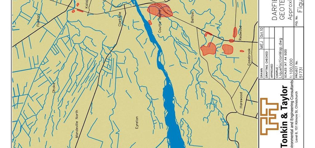
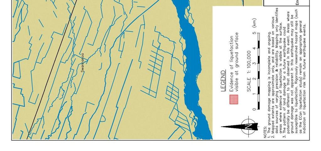
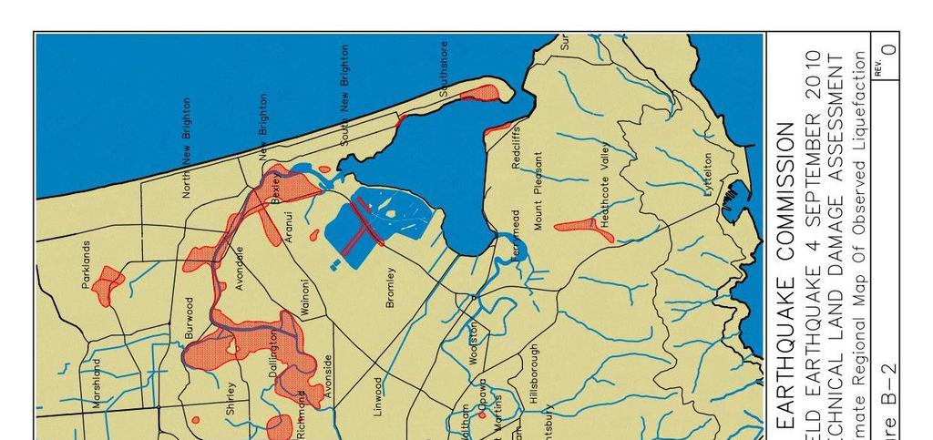
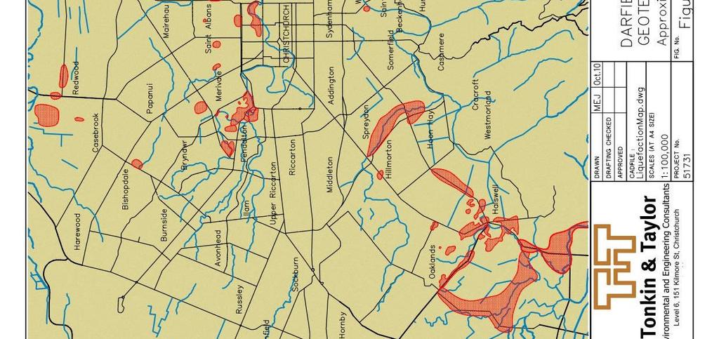
13 7 The following important points relating to the land damage mapping should be noted: The land damage mapping is ongoing. The mapped land damage zones are approximate only and are based on various data sources of varying precision and reliability. Areas where land damage was not apparent in this earthquake may still be prone to liquefaction in future earthquakes. Rigorously researched and published liquefaction hazard maps for the region remain an appropriate general indication of the extent of potential liquefaction and land damage hazard in future earthquakes. The maps in the report identify areas where land damage and evidence of liquefaction were visible at the surface at the time of inspection. It is possible that liquefaction may have occurred at depth without obvious evidence being visible at the surface, or that evidence of liquefaction may have been removed before an area was inspected. Various members of the geotechnical community in Christchurch have commented that while liquefaction has occurred in many areas where it was expected, there are many locations where liquefaction was expected under a moderate earthquake where there is no visible evidence of liquefaction in this earthquake. This emphasises that liquefaction and related land damage is not only related to the ground conditions, but also the specific characteristics of a particular earthquake (frequency content, directionality, duration etc.) 5.1 Broad assessment Geotechnical engineers from various consulting and research groups undertook rapid site reconnaissance surveys immediately following the earthquake, to identify the level of ground disturbance and record obvious damage across Christchurch. Maps were prepared to illustrate the extent of land damage within Christchurch City, Waimakariri District and Selwyn District. Due to the limited detail of this initial mapping, and the variety of sources from which information was sourced, a simple yes/no system was used as follows: Liquefaction No Liquefaction Evidence of liquefaction visible at the surface. This evidence included ejected sand, ground cracking, ground subsidence, flotation of services/ tanks, foundation bearing capacity failure. No evidence of liquefaction or land damage visible at the surface. [Note: the lack of surface evidence of liquefaction does not preclude that liquefaction may have occurred at depth]. This information was summarised on a single map, and this broad map has been split into three overlapping maps and appended to this report (refer Appendix B: Figure B-1 to B-3). These figures indicate the mapped areas where liquefaction has been observed to have occurred. This map was compiled from multiple sources and updated daily and distributed on a confidential basis to appropriate organisations involved in the response, recovery and research efforts. From our initial site reconnaissance and discussions with members of the community we observed that properties in the following areas were most severely affected by land damage: Riverside areas, particularly the inside and on some outside of bends. Areas include Avondale, Avonside, Burwood, Dallington, Kaiapoi, and parts of Fendalton, Halswell and St Martins. River delta areas. Areas include Bexley, Brooklands, Kairaki, Pines Beach, and Spencerville. Inland loose alluvial deposit areas. Areas include parts of the suburbs of Belfast, Casebrook, Fendalton, Halswell, Hoon Hay, Parklands and St Albans.
14 8 In the riverside areas, lateral spreading towards the streams and rivers caused much of the most severe damage. Such damage comprises cracking, deformation and differential settlement of buildings and pipework connections, and inundation of land and buildings with sand and water. Within river-loop areas, further inland from the river, structural damage is primarily due to differential settlement effects. In the river delta areas, a mix of lateral spreading, ground oscillation and liquefaction-related settlement has resulted in very severe to major damage to pipelines, cracking, deformation and differential settlement of buildings, and inundation of land and buildings with sand and water. In the inland loose alluvial deposit areas, damage has occurred due to ground oscillation, the ejection of sand, and liquefaction-related settlement. This appears to have resulted in generally minor to moderate damage to buildings and localised inundation of land and buildings with sand. However, differential settlement of structures may have longer-term implications for building serviceability. 5.2 Local assessment Following the broad mapping assessment, areas of very severe land damage were identified and further mapping is in the process of being undertaken by geotechnical engineers and engineering geologists on a local level. Local maps using aerial photo imagery and property boundaries sourced from Terraview (2010) at 1:3000 scale are being prepared to record the extent of the land damage. In order to simplify the assessment of the properties, land damage descriptors have been assigned to each land parcel, and the damage ranked according to the following categories (Table 5.1). These categories are aligned with international practice and the New Zealand Geotechnical Society Earthquake Engineering Practice Guidelines (NZGS, 2010). Table 5.1 Local land damage mapping categories Land Damage Zone Description Very Severe Major Description Extensive lateral spreading (>1 m) and liquefaction evidence, large open cracks, surface rupture (>100 mm) extending through the ground surface, with very severe horizontal and vertical displacement (>200 mm). Heavy structural damage to structures includes obvious lateral and vertical displacements and stretching, twisting and cracking of the structures. Damage to roads/services/houses and structures likely to require significant remedial actions or demolition. Generally, affected buildings are beyond economic repair and in most cases are likely to be uninhabitable. Extensive liquefaction evidence, large cracks from ground oscillations extending across the ground surface, with horizontal and vertical displacement (>50 mm). Damage to structures includes major differential settlement (>100 mm settlement over 10 m horizontal distance) with obvious lateral and vertical displacements along with twisting/cracking of the structures. Damage to roads/services/houses and structures likely to require major remedial actions or demolition. Generally, affected buildings are beyond economic repair and in most cases are likely to be either uninhabitable, or only habitable in the short-term.

15 9 Land Damage Zone Description Description Moderate Visible signs of liquefaction (ejected sand), small cracks from ground oscillations (<50 mm) in paved surfaces but limited depth into the underlying ground, no vertical displacement of cracks. Damage to structures includes moderate differential settlement (<100 mm settlement over 10 m horizontal distance) and twisting/ cracking of structures. Remedial work likely to be required in streets and within houses mainly being to walls and ceilings as cracking will be evident. Many foundations will likely require repairs, and remediation may be significantly complicated by differential settlement of the structure. Buildings likely to be habitable in the medium-term, but with reduced serviceability (jamming doors & windows, uneven floors and non-level surfaces) but are variable with respect to the cost to repair them. Minor No Apparent Land Damage Shaking-induced damage resulting from cyclic deformation and surface-waves causing minor structural damage and minor ground damage. Ground damage likely limited to minor cracking (tension) and buckling (compression). No signs of liquefaction obviously visible at the surface, or of lateral/vertical displacements. Minor remedial work may be required within the street, pavements and landscaping and some house may require minor repair/ relevelling work. No apparent land damage or signs of liquefaction obviously visible at the surface. Damage to structures likely to be possible due to earthquake shaking rather than ground damage. Note: Within any area it is possible that an intermixing of land damage zone descriptions will apply across adjacent properties. Local maps of the areas are currently being prepared for EQC insurance claims assessment purposes. The spatial distribution of the zones of typical land damage, as discussed in the table above is illustrated in a generic section shown in Figure 5.1. Figure 5.1. Schematic section of spatial distribution of zones of land damage
16 5.3 Local mapping assessments The initial local mapping assessment of observed damage to land within the most severely affected suburbs in Christchurch and the Canterbury region includes the areas listed in Table Table Total number of inspected properties within the local mapped damage assessments District Waimakariri District Christchurch City Suburb No. of mapped properties as at 1 October 2010 Land Damage No Apparent Land Damage Total Kaiapoi North Kaiapoi South Kairaki Beach Pines Beach Avondale Avonside Bexley Brooklands Burwood Dallington Fendalton Halswell Northcote Parklands Spencerville Wainoni Selwyn District Lincoln - Tai Tapu Total Mapping into smaller more isolated areas of land damage is continuing. Therefore the number of properties mapped with damage will continue to increase, altering the numbers in the table above. These are total numbers of properties inspected as at 1 October 2010 and do not necessarily reflect the total number of EQC claims lodged in that particular area.
17 11 6 Reconstruction Considerations 6.1 Natural hazard risks in perspective Natural hazards cannot be avoided in New Zealand. At best, we might get to choose which hazard we prefer and the level of risk we are willing to accept and manage. It is essential that decisions to rebuild or retreat are made on the basis of a proper understanding as to what has occurred, and what the probability is of a similar or greater level of earthquake shaking and ground damage occurring in the next 50 years. The earthquake related damage also needs to be considered in the wider context of geotechnical risk throughout New Zealand. The wider Christchurch area is in many respects similar to San Francisco, which has a similar risk of damaging earthquakes, and hazard mapping shows the San Francisco Bay Area to have large areas susceptible to liquefaction, areas which have been intensively developed for residential purposes. Like San Francisco, large portions of Christchurch are developed on areas subject to liquefaction, and it is not sensible to remove developments so situated. It is important to appreciate that liquefaction is just one of the hazards associated with large earthquakes and only one of numerous hazards which exist and are accepted throughout New Zealand. It also needs to be appreciated that even with the extent of the land damage that occurred, very few residential buildings actually collapsed. The injuries that did occur all resulted from falling chimneys, and these chimney falls occurred due to shaking, not land deformation arising from liquefaction. Development of all communities in New Zealand involves an acceptance of geotechnical risk. Every year on average several thousand residential properties are damaged due to earthquakes and landslips. Most of New Zealand has an appreciable earthquake and rainfall induced landslip risk. The central volcanic plateau, Rotorua district and Auckland also have an appreciable volcanic risk. Many of the towns and cities in New Zealand are built on flood plains and have a high flood hazard. Most coastal communities have a high risk of tsunami and many properties are developed on marginally stable slopes or eroding cliff tops. The landslip hazard is probably the most applicable for comparison with the hazard from liquefaction, in considering building damage. In the Northland flood events in 2007 (March and July) over a thousand residential properties were damaged by landslip related ground movement. The return period of those rainfall events were between 100 and 200 years. Rainfall events of this return period are considered extreme, and damage to buildings due to ground movement is anticipated for such low frequency events. Similar return period rainfall events caused thousands of buildings to be damaged in the eastern Bay of Plenty in 2004, Tauranga in 2005, Auckland in 2008 and Whakatane in So, the flow slides and lateral spreading associated with the liquefaction from the Darfield Earthquake need to be considered in the context of similar ground movements associated with lesser return period rainfall events in New Zealand. 6.2 Standards of repair/ replacement Under the Earthquake Commission Act 1993, the Commission may at its option replace or reinstate any property that suffers natural disaster damage, or any part thereof, instead of paying for the amount of the damage, but the Commission shall not be bound to replace or reinstate exactly or completely, but only as circumstances permit and in a reasonably sufficient manner.
18 12 Claimants not only expect their homes to be fit for purpose, i.e. weather tight, structurally sound and fully functional (doors and windows that open and close freely, floors and fittings level, framing straight and true, guttering draining to the downpipe etc), but looking as good as they did on 3 September T&T experience has shown that the latter expectation can be very difficult, if not impossible, to achieve. It is therefore essential that, before embarking on a repair option, a realistic assessment is undertaken as to the probability of achieving an acceptable result. T&T s experience with repair work has shown that even seemingly minor repair costs, very rapidly escalate beyond the EQC residential building cap of $100,000 plus GST. 6.3 Design standards The relevant building code performance requirements are set out in the Seismic Loadings Code NZS : The performance requirements for residential buildings are: - Ultimate Limit State (ULS). Under a seismic event with an annual probability of exceedence of 1 in 500 year return period, people are not to be endangered and collapse of the structure is to be avoided. - Serviceability Limit State (SLS). Under a seismic event with an annual probability of exceedence of 1 in 25 year return period, damage to the building is to be avoided. However, these performance requirements are specific to the building structure only and no reference is made to the land performance on which the building is founded. With respect to natural hazards the Building Act 2004 requires that a building be not likely to be subject to damage from erosion, subsidence, inundation or slippage. There is a similar provision in the Resource Management Act 1991 relating to subdivision consent. Interpretation of these requirements with respect to earthquake induced ground damage and its impact on structures requires a legal opinion. In the areas where liquefaction occurred (with the exception of the very severely damaged land), the residential houses have met the ULS performance requirements (i.e. there were no observed collapsed houses). In the very severe land damage areas, the houses were in varying states, but no catastrophic collapses were observed. However, this is probably more the result of building type and good construction practice in these areas rather than design expectation (as there was greater potential for loss of life to occupants in the houses in these areas). Therefore, reasonably, based on performance observations and code design practices, the houses could be rebuilt on the land (with the possible exception of the very severely damaged land) without any form of ground treatment. However, if houses are to be rebuilt in the very severely damaged areas, then specific engineered design should be required. It may be appropriate to incorporate structural measures in their redesign to allow for significant lateral spreading, or else to put in place some form of ground treatment works to limit the lateral spreading strains to more tolerable limits for the structures. For the purposes of this report we have therefore also referred to this severely damaged area as a building restriction zone.
19 13 7 Land and Building Reinstatement This section of the report contains some general comments about land and building reinstatement and broader community implications. 7.1 Suitability of land for rebuilding The land that has undergone the greatest displacement, flow sliding and lateral spreading (very severe and major land damage zones), could in some areas be protected with conventional methods that have been used in Bay of Plenty, Wellington and Canterbury for the past years and extensively overseas. As well as providing an increased level of protection to the residential developments, it is also possible to use these methods to protect essential infrastructure. Accordingly, in rebuilding the most severely affected communities, it is possible to afford them an increased level of protection, and to also protect the essential infrastructure, affording wider benefits to the community by protecting lifelines. An integrated approach to rebuilding communities and essential infrastructure should therefore be considered. At one end of the spectrum of potential reconstruction options, is complete engineering intervention (or alternatively abandonment of the land) on all land which was observed to have undergone liquefaction damage. However, this is not considered to be a necessary course of action for the reasons outlined below. At the other end of the spectrum of potential reconstruction options, the houses could simply be rebuilt on the land without any form of ground improvement. However, this may not be accepted or permitted for reasons outlined below. A number of ground restoration options have been considered, from significant engineering intervention to minimal intervention. The least disruptive and fastest option would be for councils to allow rebuilding on the land with no ground improvements other than bringing the land back to a condition comparable with that existing prior to the earthquake event. This rebuilding on unimproved ground is likely to meet building code requirements for the no land damage to major land damage category. Without the intervention of engineered ground improvements and/or a more robust building/foundation design, building code requirements would appear unlikely to be met for the very severe land damage category and a building restriction zone is likely to be applied. In some suburbs the unimproved ground option may be the most equitable as it returns the land back to a condition comparable with that existing prior to the earthquake, it is the quickest solution with the least disruption and is the most affordable. In general, this land repair would be limited to filling cracks and re-compacting the surface, as well as bringing the land back up to the pre-earthquake level wherever practical. For this option the cost of repairs would be significantly lower than the value of the land, and would form the basis for EQC compensation and would allow re-establishment of the entire community to the state it was in before the earthquake. In zones with severely damaged land, those whose houses have been significantly damaged, due to severe lateral spreading and bearing capacity failure, may not accept the status quo. Similarly councils, insurers and financial institutions may also not agree to consent and provide ongoing cover within this zone because ground deformation expected under a similar earthquake is at the limit of or beyond currently accepted design practice, unless specific engineering design is undertaken for houses to be rebuilt in such areas. Councils may allow rebuilding on the worst affected land only with ground improvements to reduce the risk of future liquefaction effects. In areas which experienced severe lateral spreading,
20 14 councils may require ground improvements and/or a more robust building/foundation design and construction to meet the ultimate limit state (ULS) performance standards set out in the building code. In addition to councils, the commercial insurers also need to determine whether they will continue to provide cover for earthquake damage in the affected areas, and if so under what conditions. Financial institutions also need to confirm that they will continue to provide mortgage finance for such areas. 7.2 Building damage and repair Building damage can be divided into two broad categories: damage that was caused solely from earthquake shaking (no land damage and minor land damage category), and damage that resulted from liquefaction induced ground deformation (minor through to very severe land damage). Photographic illustrations of observed damage are included in Appendix C (C1). Following the earthquake, local authorities (city and district councils) rapidly assessed buildings on safe and sanitary conditions providing a traffic light classification; Red unsafe; Yellow limited access; Green safe. Overall most buildings received a green notice but it is noted a significant number were posted with a red or yellow notice displacing people from their homes. Many people have no choice but to remain in their homes as there is just nowhere else for them to go. An observation from the Darfield Earthquake is that there are significant advantages in people being able to remain in their homes for as long as possible after the event. This may mean employing development practices to limit the damage so that buildings remain habitable and ultimately gain a green notice from council. The performance target should therefore include a habitability level design state. With respect to the current building damage, three broad categories (minor, moderate and severe) are applicable for insurance considerations, as summarised in Table 7.1 below. Table Categories of building damage Severity Repair Cost (Excludes GST) Description Minor <$10,000 Cracks in interior linings, non-structural cracks in the exterior. Moderate $10,000 to $100,000 Chimney damage, roof damage, minor structural damage, cracks in exterior linings which affect weather tightness. Severe >$100,000 Buildings out of level, twisted, broken through hogging or dishing, differential settlement generally more than 50 mm, stretched more than 20 mm. Building damage due to ground movement can cause stretching, hogging, dishing, racking / twisting, tilt, discontinuous foundation, global settlement or any combination of the above. The severity of the building damage is dependent on the damage type, the size of building, type of building (i.e. Group A or B type buildings, as defined below), the building geometry and the amount of foundation movement which has occurred. Approximate ranges of foundation movement for the severity of each type of building damage are given in Appendix C (C2). The purpose is to provide a quick rough order of cost estimate of the severity of building damage of the houses to indicate the likely repair cost category, so that EQC can arrive at realistic preliminary costs associated with the scope of repairs required for each house.
21 15 Generally two broad groups of buildings exist: A B Timber frame, suspended timber floor structures on timber jack studs and shallow concrete piles. Block/brick/timber frame on slab on grade and perimeter concrete strip footing. These can have a variety of exterior materials, including pre-cast concrete (tilt slabs). The apparent damage to Group A type buildings is generally easier and less costly to repair. Group B type buildings are typical of the newer subdivisions of Kaiapoi, Bexley and Brooklands, with a significant number of buildings less than 10 years old. These buildings are typically supported on a shallow reinforced concrete perimeter strip footing, with concrete cast-on-grade floors. The floors are, in many cases, unreinforced, and not tied in to the perimeter foundations. These foundation and flooring systems have been observed to perform poorly in those areas that have undergone land deformation. In addition such buildings will be difficult and more costly to repair. 8 Remediation Options If the Darfield 2010 earthquake was greater than the design (ULS) event then no engineering intervention would currently, under existing codes be considered necessary. However, if the earthquake was smaller than the design (ULS) event then some engineering intervention is likely to be required. Based on assessment to date, this report assumes the Darfield Earthquake was less than or equal to the 1 in 500 year (ULS) design event. 8.1 Broad range of initial concept options This section summarises general available conceptual remediation options for sites affected by liquefaction and lateral spreading (very severely to major land damage areas). Remediation options (Table 8.1) could typically comprise one or more of the following techniques. 1. Improvement of all or part of the affected ground to prevent liquefaction occurring in the treated ground in future. 2. Engineering structures and foundations to increase the structural resistance to the effects of liquefaction (for new structures and retrofitting of existing structures). 3. Avoiding liquefaction zones through either setbacks for new building or removal of existing buildings. 4. Surface repair of ground and acceptance or management of risk from future liquefaction events. These options are conceptual and there are a variety of detailed options available for each area. We have generally summarised the remedial options into the combinations listed below. They do not represent EQC reinstatement options, but are included to illustrate the range of approaches that may be available. Note that as discussed elsewhere in this report, a number of these options are not practical, economic or necessary. Similarly not all of the options will be appropriate in every suburb. However, for completeness the full range of options is presented below.


22 16 Table General land remedial options for liquefaction and lateral spreading areas Remediation Options A Description Complete abandonment of all lots where liquefaction ground damage has occurred. B Complete treatment of all liquefiable soil in areas where liquefaction ground damage has occurred. C Treatment of the perimeter of affected areas only, to limit future lateral spreading. In the enclosed untreated area, found structures on piles to minimise settlement from future liquefaction. D Treatment of the perimeter of affected areas only, to limit future lateral spreading. In the enclosed untreated area, found structures on a raft of strengthened ground (with robust foundation detailing) E Treatment of the perimeter of affected areas only, to limit future lateral spreading. Relevel existing structures where practical, and found new structures on piles or robust foundations if appropriate. F F1. Rebuilding with setback building restriction zone in areas of lateral spreading and significant ground damage. Beyond building restriction zones various options are available, such as a surface raft of strengthened ground, piles, or robust foundations for new structures, or relevelling of existing structures. F1. Rebuilding with large building restriction zones and founding the buildings on piles.


23 17 Remediation Options F2. F3. Description F2. Rebuilding with large building restriction zones, building a non liquefiable raft and founding these buildings on shallow timber pile or waffle slab foundations. F3. Rebuilding with large building restrictions zones, relevelling (or replacing) existing building foundations where possible and founding the new buildings on shallow timber pile or waffle slab foundations. G No ground treatment. Relevel existing buildings where practical, and founding new buildings on robust foundations if appropriate, with building restriction zones applied to very severely damaged properties. Outlined in Table 8.2 (below) the options are listed in generally reducing level of disruption to existing land, buildings and residents, typically with increasing potential damage from another earthquake. The first options in the table have major disruption to landowners, provide the greatest liquefaction mitigation or avoidance benefits, but the greatest associated cost. Assuming, for the reasons set out in Section 7.1, that both central and local government agree that remediation of land in the worst affected areas should be carried out to achieve a higher level of performance than EQC insurance cover, the following considerations need to be balanced; 1. Minimising social dislocation by avoiding options (Options A and F) which require abandonment of areas where major liquefaction and lateral spreading has occurred. 2. Minimising the reconstruction time and making homes habitable as soon as possible by avoiding options (Options B, C and D) requiring large scale demolition and reconstruction of houses which could otherwise be repaired. 3. Giving confidence to homeowners, mortgage lenders and insurers that, in a similar event (however unlikely), houses will be safer, and will suffer less damage. 4. Cost effectiveness. It is possible, at considerable financial cost and with considerable social disruption, to remediate all affected land to a very high standard. The benefits, for the cost involved, would be marginal when compared to options with less engineering intervention.
 their applicability in any suburb depends on the liquefaction and lateral spreading risk which has")
24 18 Table Land remedial options for liquefaction risks and costs for land repair (excluding rebuilding and infrastructure costs) Although the remediation options have been set out in Table 8.2 in ascending order of effectiveness, (to simplify the options for illustration and comparison) their applicability in any suburb depends on the liquefaction and lateral spreading risk which has been now identified as a result of the Darfield Earthquake. For example, in some affected suburbs, where only moderate liquefaction has occurred, and with only minor damage to houses, filling and compacting of any affected land around the house can be an acceptable solution. In areas where severe lateral spreading has occurred, resulting in the need to demolish and rebuild houses, the opportunity should be taken to treat the perimeter of the affected areas to limit the extent of lateral spreading in any future earthquake. Different remediation options will be required in different suburbs. Therefore, from and engineering perspective it is important that the selection of the remediation options in any area is determined by the standard of performance required of the land and building in a similar earthquake. This will ensure remediation is carried out to a consistent performance standard, although the remediation options themselves will differ area by area. Following a review of the above considerations and options by central and local government, and peer review by Beca Infrastructure Ltd and John Wood Consulting (Beca, 2010), T&T has been instructed, and is currently working up, Options E and G on a suburb by suburb basis. Options A to D and Option F have been discounted based on the substantially greater costs, the much longer duration and effects, and the fact that remediation to levels significantly above most of the Canterbury Plains cannot be justified.
25 19 9 References Beca Infrastructure Ltd & John Wood Consulting (Beca, 2010) Peer Review Commentary on T&T s Preliminary Report to Earthquake Commission. 1 October 2010, Ref. NZ Brown L.J. & Weeber J.H. (1992) Geology of the Christchurch Urban Area. Scale 1:25,000. Institute of Geological & Nuclear Sciences geological Map 1. Environment Canterbury (ECan, 2004) The solid facts on Christchurch Liquefaction. New Zealand Geotechnical Society (NZGS, 2010) Guidelines for Geotechnical Earthquake Engineering Practice in New Zealand. Module 1 Guideline for the identification, assessment and mitigation of liquefaction hazards. July Sewell R.J.; Weaver S.D. & Reay M.B. (1993) Geology of Banks Peninsula. Scale 1:100,000. Institute of Geological & Nuclear Sciences geological Map 3. Terraview (2010) Aerial photo sourced from Terralink International (Copyright Terralink International Limited and its Licensors) Note additional sources of information: 1. Discussions with Research Clearing House Group 10 Glossary 2. Discussions with affected communities Alluvial deposits These are formed over very long periods of time as fine particles of silt and clay, and larger particles of sand and gravel, are deposited and reshaped by water. Alluvial deposits underlie large areas of the Canterbury Plains. Bearing capacity failure The ground s ability to support foundations, and the buildings above, is termed its bearing capacity. This capacity can vary. As an example some soil types when flooded or exposed to earthquake may behave quite differently and have dramatically reduced ability to support foundations, leading to bearing capacity failure. Deposition Deposition is the geological process by which material is added to a landform or land mass. Wind and water can carry eroded materials and deposit these over extended geologic periods building up layers of sediment. Differential settlement When designing foundations for buildings the primary design concerns are settlement and the ability of the ground to support the weight (referred to as bearing capacity). All structures settle to some degree as the ground below takes the added weight. Differential settlement is when one part of a foundation settles more than another part and can cause problems to the building above. Epicentre The epicenter is the point on the earth s surface directly above the point where an earthquake rupture starts (the hypocentre). Hypocentre The hypocenter is the point within the earth where an earthquake rupture starts.
26 20 Liquefaction Liquefaction describes an event where loose soils below the groundwater level substantially lose strength and stiffness in response to an applied cyclic force, like earthquake shaking, causing the soil to behave like a pressurised liquid. For example, in some areas in Canterbury the pressurised soil/ water mixture has shot to the surface through cracks, creating sand boils, colloquially called "sand volcanoes. Lateral spreading The most severely affected areas are where land has been able to move horizontally due to its proximity to open channels or dips the land is unconstrained and can move towards these channels. In moving, cracks parallel to the channel can open up and the surface of the land can drop. Magnitude (M) This characterises the relative size of an earthquake and is based on measurement of the maximum motion recorded by a seismograph. Several scales have been defined, but the most common is the "Richter magnitude". Modified Mercalli Intensity (MM) This quantifies the effects of an earthquake on the earth's surface, with 1 denoting not felt and 12 total destruction. The values will differ based on the distance from the earthquake centre and other parameters such as ground types. Data is gathered from individuals who have experienced the quake, with aggregated information used to map intensity levels generally radiating out from the epicenter. Pore water pressures Is the pressure of groundwater held within a soil or rock, in gaps between particles (the pores). High pore water pressures effectively reduce the friction between particles increasing their potential to slide against each other and at the extreme be suspended in moving fluid such as in the case of liquefaction. Return period The return period is the average expected time between events of a certain size. For example, with smaller scale events these may be assessed to be 1 in every 25 years and for large scale events these may be assessed as 1 in every 1000 years. It is a means of quantifying risk and can be applied to all hazards including flooding and earthquakes. It is important to appreciate that even though a 1 in 25 year event may have occurred last year a similar event could still occur at any time. Serviceability Limit State (SLS) To satisfy the serviceability limit state criteria, a structure must remain functional for its intended use. In an earthquake, damage may occur such as cracking in concrete floor slabs, deflection and loss of external brick veneers but the structure remains habitable. Ultimate Limit State (ULS) This is the design level adopted when designing buildings and structures buildings must not collapse when subjected to loads similar to this design level.
27 Appendix A: Geology Maps Geology of the Christchurch Area

28 Approximate line of cross section as shown in Figure A-2 Figure A-1. Excerpt reproduced from the Geology of Banks Peninsula, Scale 1: Geological Map (Sewell et al., 1993)

29 Figure A-2. Cross section through the subsurface of Christchurch (from Brown & Weeber, 1992). Approximate cross section line as shown in Figure A-1.
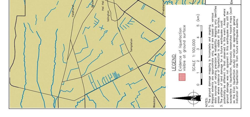
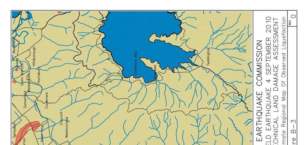
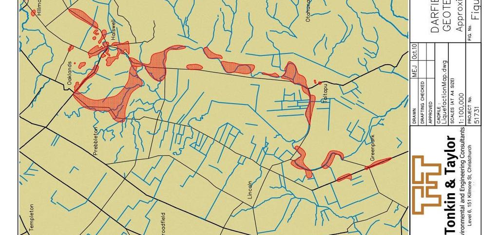
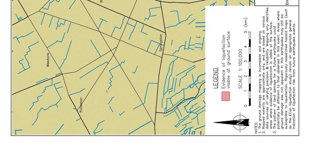
30 Appendix B: Broad Assessment Approximate Regional Maps of Observed Liquefaction Figure B-1 Figure B-2 Figure B-3

31
32
33
34 Appendix C: Damage Assessments C1 Observed Damage C2 Building Damage


 Major Land Damage Photograph C.2. Very severe land damage (lateral spreading) Photographs C.")

35 C1 - Illustration of Observed Damage The following photographs illustrate the levels of land and building damage observed in the Canterbury Region. Very Severe Land Damage Manifestations of very severe land damage include the formation of large cracks adjacent to and through buildings; inundation of sand adjacent to and throughout some buildings and rupturing of pipe networks. Examples of this type of damage are shown in Photographs C.1 and C.2. Photograph C.1. Very severe land damage (lateral spreading) Major Land Damage Photograph C.2. Very severe land damage (lateral spreading) Photographs C.3 and C.4 illustrate the effects of major land damage. Approximately 300 mm of silt and sand was observed on the ground surface in some suburbs as shown in Photograph C.3. Sand, silt and water was ejected from below the ground surface at the location of the building shown in Photograph C.4 and this resulted in the non-uniform settlement of the building shown in this photograph. Photograph C.3. Major land damage Photograph C.4. Major land damage


36 Moderate Land Damage Moderate land damage is illustrated in Photographs C.5 and C.6. Sand, silt and water was ejected from below the ground surface at each of these properties and this has resulted in the non-uniform settlement of the buildings shown in the photographs below. Photograph C.5. Moderate land damage Photograph C.6. Moderate land damage Minor Land Damage Photographs C.7 and C.8 illustrate the effects of minor land damage. No obvious damage to buildings from land movement only building damage from ground oscillations. Land damage evidence however was observed with minor cracking of the paved surfaces in and around buildings such as shown in the following photographs. Photograph C.7. Minor land damage Photograph C.8. Minor land damage


37 Building Damage/ No Land Damage Photographs C.9 and C.10 illustrate the effects of earthquake shaking alone causing building damage but with no apparent land damage nor any signs of liquefaction at the surface. Chimney damage is prevalent. Photograph C.9. Building damage Photograph C.10. Chimney damage
38 C2 Building Damage Appendix C2 - Residential building damage type and severity for Group B buildings Severity Type of Damage Minor Moderate Major Stretching 0 to 5mm 5 to 30mm >30mm Hogging 0 to 20mm 20 to 50mm >50mm Dishing 0 to 20mm 20 to 50mm >50mm Racking/Twisting 0 to 10mm 10 to 30mm >30mm Tilting 0 to 20mm 20 to 50mm >50mm Discontinuous Foundation 0 to 10mm 10 to 20mm >20mm Global Settlement 0 to 50mm 50 to 100mm >100mm
39
Area-wide geotechnical information summary for CERA zoning review panel
 Area-wide geotechnical information summary for CERA zoning review panel This document contains all the area-wide geotechnical information which was considered by CERA as part of the process for making
Area-wide geotechnical information summary for CERA zoning review panel
 Area-wide geotechnical information summary for CERA zoning review panel This document contains all the area-wide geotechnical information which was considered by CERA as part of the process for making
Area-wide geotechnical information summary for CERA zoning review panel
 Area-wide geotechnical information summary for CERA zoning review panel This document contains all the area-wide geotechnical information which was considered by CERA as part of the process for making
Area-wide geotechnical information summary for CERA zoning review panel
 Area-wide geotechnical information summary for CERA zoning review panel This document contains all the area-wide geotechnical information which was considered by CERA as part of the process for making
Earthquake Commission Darfield Earthquake Recovery Geotechnical Factual Report New Brighton
 REPORT Earthquake Commission Darfield Earthquake Recovery Geotechnical Factual Report New Brighton REPORT Earthquake Commission Darfield Earthquake Recovery Geotechnical Factual Report New Brighton Report
Hawke s Bay Liquefaction Hazard Report - Frequently Asked Questions
 Hawke s Bay Liquefaction Hazard Report - Frequently Asked Questions What is liquefaction? Liquefaction occurs when an earthquake shakes up water-logged sediments. As a result, the soil behaves like a liquid
Liquefaction induced ground damage in the Canterbury earthquakes: predictions vs. reality
 Bowen, H. J. & Jacka, M. E. () Proc. th NZGS Geotechnical Symposium. Ed. CY Chin, Queenstown Liquefaction induced ground damage in the Canterbury earthquakes: predictions vs. reality H J Bowen & M E Jacka
SHAKING AND GROUND FAILURE-INDUCED DAMAGE TO BUILDINGS BY THE 2010 AND 2011 CHRISTCHURCH EARTHQUAKES AND ITS LESSONS
 Int. Journal for Housing Science, Vol.36, No.3 pp.162-169, 2012 Published in the United States SHAKING AND GROUND FAILURE-INDUCED DAMAGE TO BUILDINGS BY THE 2010 AND 2011 CHRISTCHURCH EARTHQUAKES AND ITS
Performance and Post Earthquake Assessment of CFA Pile Ground Improvement 22 February 2011 Christchurch, New Zealand Earthquake
 Performance and Post Earthquake Assessment of CFA Pile Ground Improvement 22 February 2011 Christchurch, New Zealand Earthquake K. M. Murahidy, S. W Sutherland & M. E. Jacka Tonkin & Taylor Ltd, Christchurch,
Christchurch CBD: Lessons Learnt and Strategies for Foundation Remediation 22 February 2011 Christchurch, New Zealand, Earthquake
 Christchurch CBD: Lessons Learnt and Strategies for Foundation Remediation 22 February 2011 Christchurch, New Zealand, Earthquake K.M. Murahidy & A.F. Sleight Tonkin & Taylor Ltd, Christchurch, New Zealand
Foundations on Deep Alluvial Soils
 Canterbury Earthquakes Royal Commission Hearings 25 October 2011, Christchurch GEO.CUB.0001.1-35.1 Foundations on Deep Alluvial Soils Misko Cubrinovski, Ian McCahon, Civil and Natural Resources Engineering,
GUIDANCE D. Part D: Guidelines for the geotechnical investigation and assessment of subdivisions in the Canterbury region.
 GUIDANCE D CONTENTS Part D: Guidelines for the geotechnical investigation and assessment of subdivisions in the Canterbury region Minimum requirements for geotechnical assessment for land development (
Forms of Flat Land Damage
 Appendix B : Forms of Flat Land Damage Table B1.1 EQC Land Damage Categories for the Flat Land Areas in Christchurch Figure B1.1 - Maps of the liquefaction related land damage for the four main earthquake
Comparison between predicted liquefaction induced settlement and ground damage observed from the Canterbury earthquake sequence
 Power, P.M. & Jacka, M. (2013) the Canterbury earthquake sequence Proc. 19 th NZGS Geotechnical Symposium. Ed. CY Chin, Queenstown Comparison between predicted liquefaction induced settlement and ground
Consideration of Ground Variability Over an Area of Geological Similarity as Part of Liquefaction Assessment for Foundation Design
 6 th International Conference on Earthquake Geotechnical Engineering 1-4 November 2015 Christchurch, New Zealand Consideration of Ground Variability Over an Area of Geological Similarity as Part of Liquefaction
LSN a new methodology for characterising the effects of liquefaction in terms of relative land damage severity
 van Ballegooy, S., Lacrosse, V., Jacka, M. & Malan, P. (2013) Proc. 19 th NZGS Geotechnical Symposium. Ed. CY Chin, Queenstown LSN a new methodology for characterising the effects of liquefaction in terms
Geotechnical issues in seismic assessments: When do I need a geotechnical specialist?
 Geotechnical issues in seismic assessments: When do I need a geotechnical specialist? B.H. Rama & S.J. Palmer Tonkin & Taylor Ltd (T+T), Wellington, New Zealand. 2016 NZSEE Conference ABSTRACT: The Canterbury
Increased Liquefaction Vulnerability (ILV) Engineering Assessment
 Engineering Assessment") Increased Liquefaction Vulnerability (ILV) Engineering Assessment Increased Liquefaction Vulnerability (ILV) Engineering Assessment 2 Property details Property address 17 SAMPLE STREET, SAMPLEVILLE, CHRISTCHURCH,
Increased Liquefaction Vulnerability (ILV) Engineering Assessment Increased Liquefaction Vulnerability (ILV) Engineering Assessment 2 Property details Property address 17 SAMPLE STREET, SAMPLEVILLE, CHRISTCHURCH,
This page answers some of the questions people have been asking about the earthquakes in Christchurch and Canterbury since September 2010.
 1 of 5 04/12/2012 11:05 a.m. This page answers some of the questions people have been asking about the earthquakes in Christchurch and Canterbury since September 2010. Why are we getting so many earthquakes?
14 Geotechnical Hazards
 Volume 2: Assessment of Environmental Effects 296 14 Geotechnical Hazards Overview This Chapter provides an assessment of the underlying geotechnical conditions to identify: any potential liquefaction
Macro and micro scale assessment and quantification of Ground damage following the Canterbury 2010/2011 Earthquake sequence
 Macro and micro scale assessment and quantification of Ground damage following the Canterbury 2010/2011 Earthquake sequence S.C. Wallace & A.J. Macdonald Tonkin & Taylor Ltd. 33 Parkhouse Road, PO Box
3l NATURAL HAZARDS AND UNSTABLE GROUND
 Page 1 of Section 3l 3l NATURAL HAZARDS AND UNSTABLE GROUND 3l.1 Introduction A natural hazard is the result of natural processes that form, shape and change the environment and interact or potentially
Geotechnical Engineering and Resilience
 Chapter 14 Part G VOLUME 2 Geotechnical Engineering and Resilience Page 192 Overview Key geotechnical aspects of the Project include: Cut slopes in dune sand, including erodibility and erosion protection;
Important Concepts. Earthquake hazards can be categorized as:
 Lecture 1 Page 1 Important Concepts Monday, August 17, 2009 1:05 PM Earthquake Engineering is a branch of Civil Engineering that requires expertise in geology, seismology, civil engineering and risk assessment.
Analysis of Liquefaction-Induced Lateral Spreading Data from the 2010 Darfield and 2011 Christchurch Earthquakes
 Analysis of Liquefaction-Induced Lateral Spreading Data from the 2010 Darfield and 2011 Christchurch Earthquakes K. Robinson, B. A. Bradley, & M. Cubrinovski University of Canterbury, Christchurch, New
Case Study - Undisturbed Sampling, Cyclic Testing and Numerical Modelling of a Low Plasticity Silt
 6 th International Conference on Earthquake Geotechnical Engineering 1-4 November 2015 Christchurch, New Zealand Case Study - Undisturbed Sampling, Cyclic Testing and Numerical Modelling of a Low Plasticity
3.4 Typical Soil Profiles
 SEI.UoC.0002.11 Figure 4. Streams in central Christchurch as mapped in March 1850, superposed on aerial photography captured on 24 February 2011. Streams digitised from the Black Map of Christchurch (March
GEOLOGY AND SOILS. This chapter summarizes geologic and geotechnical aspects of the site as they relate to the Project.
 9 GEOLOGY AND SOILS INTRODUCTION This chapter summarizes geologic and geotechnical aspects of the site as they relate to the Project. This chapter utilizes information from the following reports prepared
Rosemerryn Subdivision, Lincoln Stages 10 to 18 Geotechnical Investigation Report Fulton Hogan Land Development Limited
 This information Memorandum, title or other supplementary property information (the Information ) has been prepared by Whalan and Partners Limited, trading as Bayleys ( Bayleys ) as agent for the Vendor.
Geology, Soils, and Seismicity
 Section 3.8 Geology, Soils, and Seismicity Introduction This section generally evaluates the effects of the alternatives analyzed in this Supplemental DEIS with regard to geology, soils and seismicity.
Appendix 2. Extracts from Ministry for the Environment Active Fault Guidelines 2003
 Extracts from Ministry for the Environment Active Fault Guidelines 2003 Published in July 2003 by the Ministry for the Environment Manatu Mo Te Taiao PO Box 10-362, Wellington, New Zealand ISBN: 0-478-18901
Guidelines for Geotechnical Site Investigation for Residential Building Consents in Hastings District. (Draft)
") Guidelines for Geotechnical Site Investigation for Residential Building Consents in Hastings District (Draft) December 2017 Acknowledgements These guidelines have been prepared with assistance from Tonkin
Guidelines for Geotechnical Site Investigation for Residential Building Consents in Hastings District (Draft) December 2017 Acknowledgements These guidelines have been prepared with assistance from Tonkin
Liquefaction and Foundations
 Liquefaction and Foundations Amit Prashant Indian Institute of Technology Gandhinagar Short Course on Seismic Design of Reinforced Concrete Buildings 26 30 November, 2012 What is Liquefaction? Liquefaction
Section 19.1: Forces Within Earth Section 19.2: Seismic Waves and Earth s Interior Section 19.3: Measuring and Locating.
 CH Earthquakes Section 19.1: Forces Within Earth Section 19.2: Seismic Waves and Earth s Interior Section 19.3: Measuring and Locating Earthquakes Section 19.4: Earthquakes and Society Section 19.1 Forces
PHYSICAL SCIENCE FINAL
 PHYSICAL SCIENCE FINAL Liquefaction Doreen Wallace, Tesla Grogan, Amber Ward, Erik Garcia, Cinthia Salas, Alexis Albers Liquefaction What is it? Conditions needed How it works Effects of Liquefaction Soil
An application of liquefaction hazard evaluation in urban planning
 An application of liquefaction hazard evaluation in urban planning Clive Anderson Principal Geotechnical Engineer, URS New Zealand Limited, 287 Durham Street, Christchurch, New Zealand Tim McMorran Senior
Earthquakes and Earth s Interior
 - What are Earthquakes? Earthquakes and Earth s Interior - The shaking or trembling caused by the sudden release of energy - Usually associated with faulting or breaking of rocks - Continuing adjustment
Run 028 (Note: error in UKC at start of exercise due incorrect tide input then corrected ok.)
") Run 027 RNZ Full Bridge Simulation Run Plots Final Report Be-Software August 2016 Prepared for Royal Haskoning DHV on behalf of Refining New Zealand Limited 27 Run 028 (Note: error in UKC at start of exercise
Run 027 RNZ Full Bridge Simulation Run Plots Final Report Be-Software August 2016 Prepared for Royal Haskoning DHV on behalf of Refining New Zealand Limited 27 Run 028 (Note: error in UKC at start of exercise
UGRC 144 Science and Technology in Our Lives/Geohazards
 UGRC 144 Science and Technology in Our Lives/Geohazards Session 3 Understanding Earthquakes and Earthquake Hazards Lecturer: Dr. Patrick Asamoah Sakyi Department of Earth Science, UG Contact Information:
IV. ENVIRONMENTAL IMPACT ANALYSIS G. GEOLOGY AND SOILS
 IV. ENVIRONMENTAL IMPACT ANALYSIS G. GEOLOGY AND SOILS The following section is a summary of the geotechnical report conducted for the proposed project. The Report of Geotechnical Investigation Proposed
Wainui Beach Management Strategy (WBMS) Summary of Existing Documents. GNS Tsunami Reports
 Summary of Existing Documents. GNS Tsunami Reports") Wainui Beach Management Strategy (WBMS) Summary of Existing Documents GNS Tsunami Reports a) Review of Tsunami Hazard and Risk in New Zealand ( National Risk Report ) b) Review of New Zealand s Preparedness
Wainui Beach Management Strategy (WBMS) Summary of Existing Documents GNS Tsunami Reports a) Review of Tsunami Hazard and Risk in New Zealand ( National Risk Report ) b) Review of New Zealand s Preparedness
Harmonized European standards for construction in Egypt
 Harmonized European standards for construction in Egypt EN 1998 - Design of structures for earthquake resistance Jean-Armand Calgaro Chairman of CEN/TC250 Organised with the support of the Egyptian Organization
IAEA SAFETY STANDARDS Geotechnical Aspects of Site Evaluation and Foundations in NPPs, NS-G-3.6
 IAEA SAFETY STANDARDS Geotechnical Aspects of Site Evaluation and Foundations in NPPs, NS-G-3.6 Regional Workshop on Volcanic, Seismic, and Tsunami Hazard Assessment Related to NPP Siting Activities and
REPORT. Ngai Tahu Property Ltd. Wigram Skies Subdivision Geotechnical Assessment
 REPORT Ngai Tahu Property Ltd Wigram Skies Subdivision Geotechnical Assessment REPORT Ngai Tahu Property Ltd Wigram Skies Subdivision Geotechnical Assessment Report prepared for: Ngai Tahu Property Ltd
9. GEOLOGY, SOILS, AND MINERALS
 June 28, 2018 Page 9-1 9. GEOLOGY, SOILS, AND MINERALS This EIR chapter describes the existing geological, soil, and mineral conditions in the planning area. The chapter includes the regulatory framework
Magnitude 6.3 SOUTH ISLAND OF NEW ZEALAND
 A magnitude 6.3 earthquake shook the southern New Zealand city of Christchurch. At least 100 people are reported dead, and there are reports of collapsed buildings, cracked streets and flooding due to
Earthquake Risk Assessment of Flood Protection Assets in the Wellington Region
 Earthquake Risk Assessment of Flood Protection Assets in the Wellington Region A. K. Murashev, R Davey, P. Brabhaharan & B. Curley Opus International Consultants Limited, Wellington, New Zealand. 2006
Study of the liquefaction phenomenon due to an earthquake: case study of Urayasu city
 Disaster Management and Human Health Risk III 311 Study of the liquefaction phenomenon due to an earthquake: case study of Urayasu city S. Kamao 1, M. Takezawa 1, K. Yamada 1, S. Jinno 1, T. Shinoda 1
Residual Deformation Analyses to Demonstrate the Effect of Thin Steel Sheet Piles on Liquefaction-Induced Penetration Settlement of Wooden Houses
 6 th International Conference on Earthquake Geotechnical Engineering 1-4 November 2015 Christchurch, New Zealand Residual Deformation Analyses to Demonstrate the Effect of Thin Steel Sheet Piles on Liquefaction-Induced
SLOPE STABILITY EVALUATION AND ACCEPTANCE STANDARDS
 INFORMATION BULLETIN / PUBLIC - BUILDING CODE REFERENCE NO.: LABC 7006.3, 7014.1 Effective: 01-01-2017 DOCUMENT NO.: P/BC 2017-049 Revised: 12-21-2016 Previously Issued As: P/BC 2014-049 SLOPE STABILITY
Update on the It s Our Fault project
 Report 12.552 Date 29 October 2012 File 12/01/01 Committee Author CDEM Group Bruce Pepperell, Regional Manager, WREMO Update on the It s Our Fault project 1. Purpose To inform the CDEM Group of progress
Impact : Changes to Existing Topography (Less than Significant)
") 4.2 Land Resources 4.2.1 Alternative A Proposed Action Impact 4.2.1-1: Changes to Existing Topography (Less than Significant) Development of the project site would involve grading and other earthwork as
4.2 Land Resources 4.2.1 Alternative A Proposed Action Impact 4.2.1-1: Changes to Existing Topography (Less than Significant) Development of the project site would involve grading and other earthwork as
The Impact of the 2010 Darfield (Canterbury) Earthquake on the Geodetic Infrastructure in New Zealand 1
 Earthquake on the Geodetic Infrastructure in New Zealand 1") The Impact of the 2010 Darfield (Canterbury) Earthquake on the Geodetic Infrastructure in New Zealand 1 Graeme BLICK, John BEAVAN, Chris CROOK, Nic DONNELLY Keywords: Darfield Earthquake, control, survey,
The Impact of the 2010 Darfield (Canterbury) Earthquake on the Geodetic Infrastructure in New Zealand 1 Graeme BLICK, John BEAVAN, Chris CROOK, Nic DONNELLY Keywords: Darfield Earthquake, control, survey,
5 Information used for the ILV Assessment
 43 5 Information used for the ILV Assessment 5.1 Purpose and Outline In this section of the report the sources of information used in the ILV Assessment Methodology are described. The sources of information
Forces in Earth s Crust
 Name Date Class Earthquakes Section Summary Forces in Earth s Crust Guide for Reading How does stress in the crust change Earth s surface? Where are faults usually found, and why do they form? What land
Downtown Anchorage Seismic Risk Assessment & Land Use Regulations to Mitigate Seismic Risk
 Prepared for: The Municipality of Anchorage Planning Department and the Geotechnical Advisory Commission Downtown Anchorage Seismic Risk Assessment & Land Use Regulations to Mitigate Seismic Risk Prepared
Hydraulic uplift forces on basements subject to liquefaction
 Hydraulic uplift forces on basements subject to liquefaction N.S. Luxford Babbage Consultants Ltd 2014 NZSEE Conference ABSTRACT: As a result of the 22 February 2011 earthquake in Christchurch a building
Natural hazards in Glenorchy Summary Report May 2010
 Natural hazards in Glenorchy Summary Report May 2010 Contents Glenorchy s hazardscape Environment setting Flood hazard Earthquakes and seismic hazards Hazards Mass movement Summary Glossary Introduction
3.0 SUMMARY OF POTENTIAL GEOTECHNICAL IMPACTS AND MITIGATION MEASURES
 3.0 SUMMARY OF POTENTIAL GEOTECHNICAL IMPACTS AND MITIGATION MEASURES This section summarizes the principal geotechnical conditions that occur in the project area. The potential impact that each condition
Geotechnical Completion Report Knights Stream Park Stage3A Development (Lots 107 to 148)
") Aurecon New Zealand Limited Unit 1, 150 Cavendish Road Casebrook Christchurch 8051 PO Box 1061 Christchurch 8140 New Zealand T F E W +64 3 366 0821 +64 3 379 6955 christchurch@aurecongroup.com aurecongroup.com
Aurecon New Zealand Limited Unit 1, 150 Cavendish Road Casebrook Christchurch 8051 PO Box 1061 Christchurch 8140 New Zealand T F E W +64 3 366 0821 +64 3 379 6955 christchurch@aurecongroup.com aurecongroup.com
Lyttelton Port Company Limited Submitter 915 / FS Statement of evidence of Neil James Charters
 Before the Independent Hearings Panel at Christchurch under: in the matter of: and: the Resource Management Act 1991 and the Canterbury Earthquake (Christchurch Replacement District Plan) Order 2014 submissions
ADDITIONAL RESOURCES. Duration of resource: 30 Minutes. Year of Production: Stock code: VEA Resource written by: Andrew Clarke BA Dip Tchg
 ADDITIONAL RESOURCES The destructive and unexpected nature of earthquakes has remained a constant threat since civilisation began. Suitable for all secondary audiences, this two-part program firstly examines
The key natural hazards relevant to the Project area relate to seismic activity and flood risk.
 21. NATURAL HAZARDS Overview The key natural hazards relevant to the Project area relate to seismic activity and flood risk. Seismic activity, including ground shaking and liquefaction, is a significant
SECTION 3. Housing. EAppendix E GEOLOGIC AND SEISMIC HAZARDS
 SECTION 3 Housing EAppendix E GEOLOGIC AND SEISMIC HAZARDS E-2 Housing Commission Attachment B Appendix E Geologic and Seismic Hazards The following definitions provide a more comprehensive discussion
Guidelines for Site-Specific Seismic Hazard Reports for Essential and Hazardous Facilities and Major and Special-Occupancy Structures in Oregon
 Guidelines for Site-Specific Seismic Hazard Reports for Essential and Hazardous Facilities and Major and Special-Occupancy Structures in Oregon By the Oregon Board of Geologist Examiners and the Oregon
Section Forces Within Earth. 8 th Grade Earth & Space Science - Class Notes
 Section 19.1 - Forces Within Earth 8 th Grade Earth & Space Science - Class Notes Stress and Strain Stress - is the total force acting on crustal rocks per unit of area (cause) Strain deformation of materials
An entire branch of Earth science, called, is devoted to the study of earthquakes.
 Lesson One Essential Question Where do earthquakes take place? What causes earthquakes? What are three different types of faults that occur at plate boundaries? How does energy from earthquakes travels
 265 Dalewood Way alteration permit #2016/02/17/9761 June 30, 2016 Appeal #16-109 Deck at Rear due to conflict with Slope Protection Act A. Executive Summary: We are in receipt of the Notification of Structural
appendix e: geologic and seismic hazards
 appendix e: geologic and seismic hazards CONTENTS: E-2 Fault Rupture E-3 Ground Shaking E-5 Seismic Ground Deformation E-5 Liquification E-6 Seismically Induces Landslide E-6 Landslide Hazard E The following
NZ Transport Agency s Detailed Design Guidance for Piled Bridges at Sites Prone to Liquefaction and Lateral Spreading
 Keepa, C., Adhikari, G., Murashev, A., Cubrinovski, M. & Lloyd, N. (2017) NZ Transport Agency s Detailed Design Guidance for Piled Bridges at Sites Prone to Liquefaction and Lateral Spreading Proc. 20
Earthquake Commission. Darfield Earthquake Recovery Geotechnical Factual Report Avondale
 REPORT Earthquake Commission Darfield Earthquake Recovery Geotechnical Factual Report Avondale REPORT Earthquake Commission Darfield Earthquake Recovery Geotechnical Factual Report Avondale Report prepared
Effective stress analysis of pile foundations in liquefiable soil
 Effective stress analysis of pile foundations in liquefiable soil H. J. Bowen, M. Cubrinovski University of Canterbury, Christchurch, New Zealand. M. E. Jacka Tonkin and Taylor Ltd., Christchurch, New
Three Fs of earthquakes: forces, faults, and friction. Slow accumulation and rapid release of elastic energy.
 Earthquake Machine Stick-slip: Elastic Rebound Theory Jerky motions on faults produce EQs Three Fs of earthquakes: forces, faults, and friction. Slow accumulation and rapid release of elastic energy. Three
Micro Seismic Hazard Analysis
 Micro Seismic Hazard Analysis Mark van der Meijde INTERNATIONAL INSTITUTE FOR GEO-INFORMATION SCIENCE AND EARTH OBSERVATION Overview Site effects Soft ground effect Topographic effect Liquefaction Methods
New Zealand s Next Top Model: integrating tsunami modelling into land use planning
 New Zealand s Next Top Model: integrating tsunami modelling into land use planning Wendy Saunders (MZNZPI), Gegar Prasetya, Graham Leonard GNS Science, Lower Hutt, w.saunders@gns.cri.nz In April 2011 a
Need of Proper Development in Hilly Urban Areas to Avoid
 Need of Proper Development in Hilly Urban Areas to Avoid Landslide Hazard Dr. Arvind Phukan, P.E. Cosultant/Former Professor of Civil Engineering University of Alaska, Anchorage, USA RI District Governor
REPORT. Liquefaction Vulnerability and Geotechnical Assessment Guidance for Gisborne District Council. Gisborne District Council.
 REPORT Liquefaction Vulnerability and Geotechnical Assessment Guidance for Gisborne District Council Prepared for: Gisborne District Council May 2015 Job No: 30214.v1 105 Carlton Gore Road, Newmarket,
Just add water: when should liquefaction be considered in land use planning? GNS Science Miscellaneous Series 47
 Just add water: when should liquefaction be considered in land use planning? W. S.A. Saunders and K.R. Berryman GNS Science Miscellaneous Series 47 December 2012 BIBLIOGRAPHIC REFERENCE Saunders, W. S.
Imaging Unknown Faults in Christchurch, New Zealand, after a M6.2 Earthquake
 Imaging Unknown Faults in Christchurch, New Zealand, after a M6.2 Earthquake D.C. Lawton* (University of Calgary), M.B. Bertram (University of Calgary), K.W. Hall (University of Calgary), K.L. Bertram
Operative Chapter 13 Natural Hazards 31 January 2015 NATURAL HAZARDS
 CHAPTER 13: NATURAL HAZARDS 13.0 INTRODUCTION Natural hazards have the potential to damage property, infrastructure and ecosystems, and threaten health and safety. Remedying the damage can cost individuals
M 7.1 EARTHQUAKE 5KM ENE OF RABOSO, MEXICO EXACT LOCATION: N W DEPTH: 51.0KM SEPTEMBER 19, 1:14 LOCAL TIME
 M 7.1 EARTHQUAKE 5KM ENE OF RABOSO, MEXICO EXACT LOCATION: 18.584 N 98.399 W DEPTH: 51.0KM SEPTEMBER 19, 2017 @ 1:14 LOCAL TIME Photo: Eduardo Verdugo / AP Photo: Alfredo Estrella/ Agence France-Presse/
Canterbury Earthquake Sequence: Increased Liquefaction Vulnerability Assessment Methodology
 Canterbury Earthquake Sequence: Increased Liquefaction Vulnerability Assessment Methodology Prepared for Chapman Tripp acting on behalf of the Earthquake Commission (EQC) Prepared by Date Job Number 52010.140.v1.0
Earthquakes. Building Earth s Surface, Part 2. Science 330 Summer What is an earthquake?
 Earthquakes Building Earth s Surface, Part 2 Science 330 Summer 2005 What is an earthquake? An earthquake is the vibration of Earth produced by the rapid release of energy Energy released radiates in all
Technical Note 04 The Liquefaction Phenomenon
 Technical Note 04 The Liquefaction Phenomenon Introduction Earthquakes pose hazards to the built environment through five main types of processes. These include strong ground shaking (the most pervasive
REPORT Palmerston North City Council
 REPORT Palmerston North City Council North East Industrial Zone Liquefaction Assessment - Interpretive Geotechnical Report & Desk Top Ground Contamination Assessment. 71 72 REPORT Palmerston North City
REPORT ON THE TOHOKU AREA PASIFIC OFFSHORE EARTHQUAKE
 REPORT ON THE TOHOKU AREA PASIFIC OFFSHORE EARTHQUAKE GENERAL PERSPECTIVE The Highest Magnitude Ever Recorded The 2011 off the Pacific Coast of Tohoku Earthquake (hereafter, the 2011 Tohoku- Pacific Earthquake
IV. ENVIRONMENTAL IMPACT ANALYSIS E. GEOLOGY AND SOILS
 IV. ENVIRONMENTAL IMPACT ANALYSIS E. GEOLOGY AND SOILS The following section is a summary of the geotechnical report conducted for the Proposed Project. The Geotechnical Engineering Investigation (the
Geotechnical Extreme Events Reconnaissance Report:
 Geotechnical Extreme Events Reconnaissance Report: The Performance of Structures in Densely Urbanized Areas Affected by Surface Fault Rupture During the August 24, 2014 M6 South Napa Earthquake, California,
SLOPE STABILITY EVALUATION AND ACCEPTANCE STANDARDS
 INFORMATION BULLETIN / PUBLIC - BUILDING CODE REFERENCE NO.: LAMC 98.0508 Effective: 1-26-84 DOCUMENT NO. P/BC 2002-049 Revised: 11-1-02 Previously Issued As: RGA #1-84 SLOPE STABILITY EVALUATION AND ACCEPTANCE
Chapter 11 10/30/2013. Mass Wasting. Introduction. Factors That Influence Mass Wasting. Introduction. Factors That Influence Mass Wasting
 Introduction Chapter 11 Mass wasting - The downslope movement of material resulting from the force of gravity. Mass Wasting Mass wasting results when the force of gravity acting on a slope exceeds the
COMMUNITY DEVELOPMENT DEPARTMENT POLICY & PROCEDURE
 COMMUNITY DEVELOPMENT DEPARTMENT POLICY & PROCEDURE Policy No: DSP-OO3 Release Date: January 1, 2014 Effective Date: January 1, 2014 Revision Date: March 1, 2018 TITLE: The City Policy for Site Specific
2012 Caernarfon Award Submission New Zealand LAND DAMAGE ASSESSMENT LIQUEFACTION & LATERAL SPREAD
 2012 Caernarfon Award Submission New Zealand LAND DAMAGE ASSESSMENT LIQUEFACTION & LATERAL SPREAD Presented by Murray Discombe Fraser Thomas Ltd, Auckland at the Annual QuarryNZ Conference Wellington,
Steps to Reduce the Risk of Tornado Damage in Commercial Structures
 Hanover Risk Solutions Steps to Reduce the Risk of Tornado Damage in Commercial Structures About 1,000 tornadoes occur each year in the United States, causing an average of $1.1 billion in property damage
Earthquake. earthquake, epicenters in the U.S. Kobe, Japan deaths
 Kobe, Japan 1995 5000 deaths Earthquakes It is estimated that there are 500,000 detectable earthquakes in the world each year. 100,000 of those can be felt, and 100 of them cause damage. The world's deadliest
Prof. B V S Viswanadham, Department of Civil Engineering, IIT Bombay
 19 Module 5: Lecture -1 on Stability of Slopes Contents Stability analysis of a slope and finding critical slip surface; Sudden Draw down condition, effective stress and total stress analysis; Seismic
STATEMENT OF EVIDENCE OF SHANE LANDER (GEOTECHNICAL - QD2) ON BEHALF OF MURPHYS DEVELOPMENTS LIMITED
 ON BEHALF OF MURPHYS DEVELOPMENTS LIMITED") IN THE MATTER of the Housing Accords and Special Housing Areas Act 2013 ("HASHAA") AND IN THE MATTER of Proposed Qualifying Development Application ("QD2") for 125 Murphys Road, Flat Bush BETWEEN Murphys
IN THE MATTER of the Housing Accords and Special Housing Areas Act 2013 ("HASHAA") AND IN THE MATTER of Proposed Qualifying Development Application ("QD2") for 125 Murphys Road, Flat Bush BETWEEN Murphys
Earthquake Hazards. Tsunami
 Earthquake Hazards Tsunami Measuring Earthquakes Two measurements that describe the power or strength of an earthquake are: Intensity a measure of the degree of earthquake shaking at a given locale based
Seismic Hazard Abatement Program
 Seismic Hazard Abatement Program Recommendations To take the first steps toward a seismic mitigation program for older existing buildings To improve our current regulatory system for implementation of
Land-use planning and volcanic hazards: Opportunities for New Zealand
 Land-use planning and volcanic hazards: Opportunities for New Zealand Julia Becker, Wendy Saunders, Graham Leonard, David Johnston, Lower Hutt Clare Robertson, Massey University, Palmerston North Presentation
Reliability of lateral stretch estimates in Canterbury earthquakes
 Reliability of lateral stretch estimates in 2010-2011 Canterbury earthquakes Proc. 19 th NZGS Geotechnical Symposium. Ed. CY Chin, Queenstown Reliability of lateral stretch estimates in 2010-2011 Canterbury