WIND AND MOUNTAIN CLIMATOLOGY IN SEVERE ENVIRONMENTS UNIVERSITY OF MASSACHUSETTS CLIMATOLOGICAL RESEARCH IN THE WHITE MOUNTAINS, NH SELECTED
|
|
|
- Ariel Glenn
- 5 years ago
- Views:
Transcription


1 WIND AND MOUNTAIN CLIMATOLOGY IN SEVERE ENVIRONMENTS UNIVERSITY OF MASSACHUSETTS CLIMATOLOGICAL RESEARCH IN THE WHITE MOUNTAINS, NH SELECTED DATA AND SLIDES

.")
2 THE UNIVERSITY OF MASSACHUSETTS PROJECT WAS SUPPORTED BY THE U. S. FOREST SERVICE, THE STATE OF NEW HAMPSHIRE, AND MOUNT HOLYOKE COLLEGE DURING THE FIELD SEASON. SEVERAL UMASS DEPARTMENTS AND THE PHYSICAL PLANT PROVIDED SIGNIFICANT ASSISTANCE, AND THE FOLLOWING INDIVIDUALS CONTRIBUTED MANY HOURS OF FIELD WORK: GEORGE MORIN ANDREW GALE EDD VITAGLIANO JEFF HAMILTON TOM LAHEY DAN O OKEEFE SPECIAL THANKS ARE NEEDED FOR THE CONTINUOUS SUPPORT OF THESIS ADVISORS AND PROFESSORS TERRY BURKE (UMASS DEPARTMENT OF GEOGRAPHY), AND MINNIE LEMAIRE (MOUNT HOLYOKE COLLEGE DEPARTMENT OF GEOGRAPHY). GUY GOSSELIN OF THE MOUNT WASHINGTON OBSERVATORY AND LEE VINCENT OF WMTW, AMONG OTHERS, PROVIDED INVALUABLE SUPPORT AND ASSISTANCE BOTH DURING THE PROJECT AND IN SUBSEQUENT YEARS OF FIELD RESEARCH. THIS MATERIAL WAS SCANNED FROM SELECTED ORIGINAL UMASS DATA AND PHOTOS FROM A PROJECT WHICH OCCURRED SOME 40 YEARS AGO, AND IS MADE AVAILABLE IN THE INTERESTS OF HISTORICAL CLIMATOLOGY. ONLY A SAMPLE OF THE FIGURES AND TABLES ARE INCLUDED. DUE TO INHERENT DIFFERENCES OF THE ERA IN WIND SENSORS AND RESPONSE CHARACTERISTICS (PARTICULARLY BETWEEN MOUNT WASHINGTON S OLDER PITOT-WHICH HAD ITS OWN ICING AND PRESSURE TUBE ISSUES - AND THE CANNON MOUNTAIN HEATED 3-CUPS), AS WELL AS DIFFERENCES IN EXPOSURE, IT MAY NOT BE POSSIBLE TO COMPARE ABSOLUTE MAXIMUM VALUES BETWEEN SITES. CLOSE ATTENTION WAS PAID TO THE CALIBRATION OF EACH SYSTEM AT THE TIME, AND THE CANNON MOUNTAIN SENSORS UNDERWENT PRE- AND POST-EVENT CALIBRATION AND WIND TUNNEL TESTS. ALL THINGS BEING EQUAL, IT IS ONLY POSSIBLE TO COMPARE ABSOLUTE VALUES BETWEEN SITES WHEN THE SAME CALIBRATION-TESTED SENSORS ARE DEPLOYED. SEVERE ICING ALWAYS PLAYS AN IMPORTANT ROLE, AND MAY DIFFER IN TIME AND PLACE. PERHAPS MORE NOTEWORTHY IS THE RELATIVE DIFFERENCES AND TRENDS RECORDED BETWEEN SITES FOR A VARIETY OF METEOROLOGICAL PARAMETERS DURING STORMS IN THE WHITE MOUNTAINS. SIGNIFICANT DIFFERENCES IN SUBSYNOPTIC VARIABLES OCCUR, BUT IN THE FINAL ANALYSIS, MOUNT WASHINGTON S UNIQUE AND ROBUST PITOT SYSTEM WAS - AND IS TODAY - THE MOST RELIABLE AND DURABLE IN SUCH AN EXTREME ICING ENVIRONMENT.


3 INFRARED ANEMOMETER DE-ICER CANNON MOUNTAIN T-46 TOWER. THE SENSOR TEMPERATURE WAS CONTROLLED BY A THERMISTOR IN THE SENSOR HUB, WHICH IN TURN REGULATED A RHEOSTAT FOR TWO 500-WATT INFRARED HEAT LAMPS. THIS WORKED QUITE WELL WITH REGULAR MANUAL DE-ICING. THE HUB ASSEMBLY WAS SPECIALLY-REINFORCED AND ATTACHED TO THE SHAFT FOR SUPERHURRICANE WINDS.. THE TITLE PAGE SENSOR, OVERLOOKING MOUNT LAFAYETTE, HAD A SIMILAR DESIGN. ITS LOCATION, ON THE OLD TRAMWAY BUILDING, PROVIDED EXCELLENT EXPOSURE TO THE SE. THE EXPOSURE IS VERY DIFFERENT FROM THAT OF THE CURRENT TRAMWAY SUMMIT BUILDING.


4 UNATTENDED EARLY DE-ICING TESTS ON NORTH SIDE OF CANNON MOUNTAIN, UMASS

5 AEROVANE WIND SENSOR UNIVERSITY OF MASSACHUSETTS CLIMATOLOGICAL RESEARCH PROJECT, WHITE MOUNTAIN NATIONAL FOREST, BASE OF OPERATIONS, TWIN MOUNTAIN, NH

6 AEROVANE WIND SENSOR MOUNT WASHINGTON UNIVERSITY OF MASSACHUSETTS CLIMATOLOGICAL RESEARCH PROJECT, WHITE MOUNTAIN NATIONAL FOREST, SITE A, LOOKING EAST BASE OF OPERATIONS, TWIN MOUNTAIN, NH
7 SELECTED FIGURES IN TEXT 1. University of Massachusetts Climatological Research Project study area. 2. Generalized scheme of the study area, Northern New Hampshire. 3. Relief map, Project Terrain. 4. Research sites for the study of winds, White Mountain National Forest, New Hampshire, Maximum wind regimes for sites A,B,O, and Z for September Maximum wind regimes for sites A.B,O, and Z for October Maximum wind regimes for sites A,B,O, and Z for November Maximum wind regimes for sites A,B,O, and Z for December Maximum wind regimes for sites A,B,O, and Z for January Maximum wind regimes for sites A,B,O, and Z for February Maximum Wind regimes for sites A,B,O, and Z for March Daily direction of maxima for sites A,O and Z for October Daily direction of maxima for sites A,O, and Z for December Daily direction of maxima for sites A,O, and Z for February The frequency of occurrence of hurricane force (->74 MPH) and extreme (->100 MPH) winds, Cannon Summit, September 1972-April Site variation of prevailing diurnal wind direction, December 1-31, 1972 (744-hour sample). 17. Diurnal variation of hourly wind direction. 15 February sites A,V, and O hour variation of wind directions between sites A,H,V, and 0 during the storm of November Research sites for the study of atmospheric pressure, White Mountain National Forest Research sites for the study of air temperature, White Mountains National Forest The diurnal maximum/minimum temperature regimes at sites A,O, and Z for January Daily mean temperatures at sites A,O, and Z for February The diurnal maximum/minimum temperature regimes at sites A,B, and I for the period December Research sites for the study of melted precipitation, White Mountain National Forest, Research sites for the study of snow conditions, White Mountain National Forest Variation of snow depths with time evolution, all sites. 27. Grain shape. 28. Grain size. 29. Strength/hardness. 30. Snow temperature at 10 cm. 31. Snow surface roughness. 32. Size of particles. 33. Surface penetrability. 34. Vertical snow depth. 35. Snow surface roughness. 36. Research sites for the study of water temperatures, White Mountain National Forest, Seasonal variation of water temperatures within the study area, sites H,R, and S, 10 September November Research sites for the study of soil temperatures, White Mountain National Forest
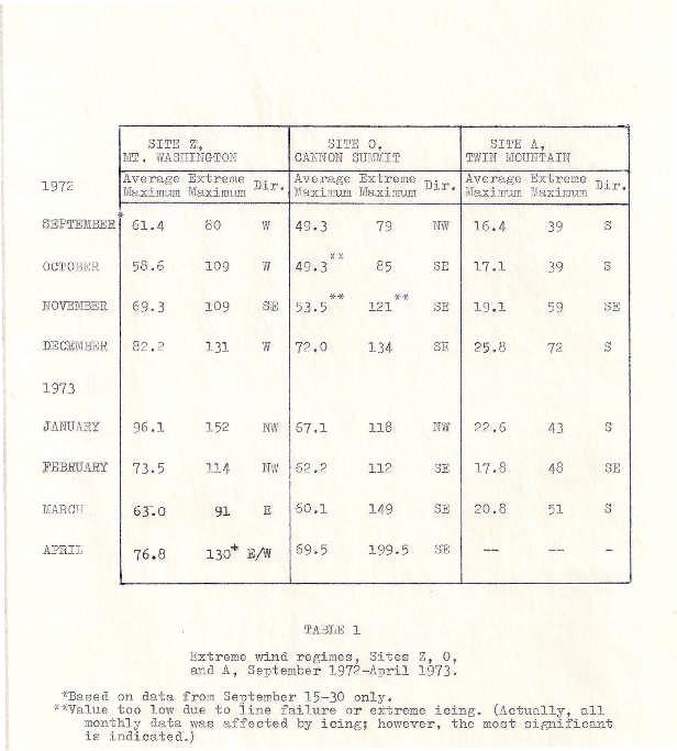
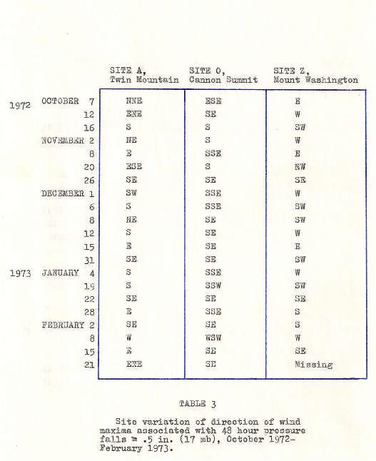
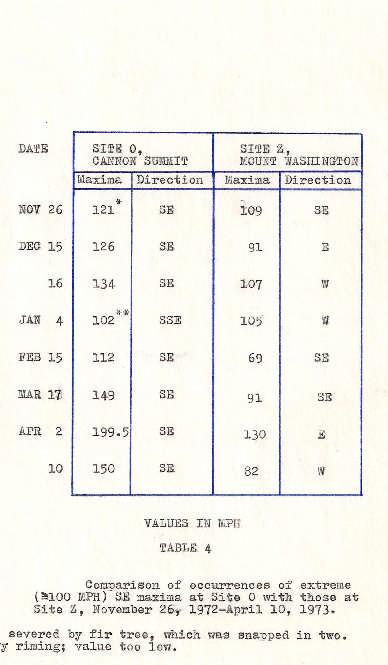
8 SELECTED TABLES IN TEXT 1. Extreme wind regimes, sites Z,O, and A, September 1972-April Period site comparison of wind maxima, September 24, 1972-April sites B,A,K,O, and Z. 3. Site variation of direction of wind maxima associated with 48 hour pressure falls ->5 in. (~17 mb), October 1972-February Comparison of occurrences of extreme (->100 MPH) SE maxima at site 0 with those at site Z, November 26, 1972, April 10, hour (12 day) distribution of wind directions. November 19-30, 1972, sites A,H,V, and O hour dist'ribution of hourly wind directions. November , sites A,R,V. and O. 7. Atmospheric pressure regime for sites A and N, September 1972-March (values reduced to sea-level), inches of mercury. 8. Temperature regime for sites A,B,O. and Z, September 1972-March Total monthly precipitation (melted) and number of days with precipitation for sites A and Z, September 1972-April Selected relative precipitation values for short intervals. sites B,H,K,I. and Y, (Values in inches.) 11. Climatological summary for site A, Twin Mountain. September 1972-January , Average daily snowfall at site A, September January Monthly snowfall for site A, September January Average daily new snow increment for each month. September 1972-January 1973, site A. 15. Extreme maximum snow depth for the study period, September 1972-January 1973, site A. 16. Extreme minimum snow depth for the study period, September January 1973, site A. 17. Average snow depth for each month. September January 1973, site A. 18. Average depth of snow cover for each month. September 1972-January site A. 19. Number of snow cover days for each month. September 1972-January site A. 20. Number of snowfall days (including Traces) for each month, September 1972-January site A. 21. New snow depths measured on 15 November 1972, selected sites. 22. Site comparison of state of deposited snow, 10 January Site comparison of state of deposited snow, 7 February Site comparison of state of deposited snow, 20 February Complete soil temperature regime for site A, September 1972-March 1973.

9 B A TO SITE X MWO H L C DE F G Y I J K v N O M ORIGINAL TOPO SITE MAP UMASS CLIMATOLOGICAL RESEARCH PROJECT, , WHITE MOUNTAIN NATIONAL FOREST SELECTED RESEARCH SITES

10 UNIVERSITY OF MASSACHUSETTS CLIMATOLOGICAL RESEARCH PROJECT, WHITE MOUNTAIN NATIONAL FOREST ZEALAND NOTCH WIND RESEARCH (SITE K). THIS SITE COMPARED GUSTS WITH THOSE AT FRANCONIA NOTCH BASE, WHICH OFTEN HAD DAMAGING, TOPOGRAPHICALLY-INDUCED SE WINDS ORIGINATING FROM MOUNT LAFAYETTE. UMASS

11 UNIVERSITY OF MASSACHUSETTS CLIMATOLOGICAL RESEARCH PROJECT, WHITE MOUNTAIN NATIONAL FOREST LOWER ZEALAND VALLEY (SITE H)

12 TWIN MOUNTAIN ROUTE 302 CANNON SUMMIT MWO MAXIMUM WIND SPEEDS RECORDED UMASS CLIMATOLOGICAL RESEARCH PROJECT

13 MAXIMUM WIND SPEEDS RECORDED UMASS CLIMATOLOGICAL RESEARCH PROJECT TWIN MOUNTAIN ROUTE 302 CANNON SUMMIT MWO

14 MAXIMUM WIND SPEEDS RECORDED UMASS CLIMATOLOGICAL RESEARCH PROJECT TWIN MOUNTAIN ROUTE 302 CANNON SUMMIT MWO

15 MAXIMUM WIND SPEEDS RECORDED UMASS CLIMATOLOGICAL RESEARCH PROJECT TWIN MOUNTAIN ROUTE 302 CANNON SUMMIT MWO

16 MAXIMUM WIND SPEEDS RECORDED UMASS CLIMATOLOGICAL RESEARCH PROJECT TWIN MOUNTAIN ROUTE 302 CANNON SUMMIT MWO


17 LOOKING SOUTH FROM SUMMIT WIND SENSORS FRANCONIA NOTCH MT. LAFAYETTE UNHEATED BELFORT WIND SENSORS, CANNON MOUNTAIN UMASS CLIMATOLOGICAL RESEARCH PROJECT,

18 MAXIMUM WIND SPEEDS RECORDED UMASS CLIMATOLOGICAL RESEARCH PROJECT TWIN MOUNTAIN ROUTE 302 CANNON SUMMIT MWO

19 MAXIMUM WIND SPEEDS RECORDED UMASS CLIMATOLOGICAL RESEARCH PROJECT TWIN MOUNTAIN ROUTE 302 CANNON SUMMIT MWO

20 DIRECTION OF WIND MAXIMA UMASS CLIMATOLOGICAL RESEARCH PROJECT

21 DIRECTION OF WIND MAXIMA UMASS CLIMATOLOGICAL RESEARCH PROJECT

22 DIRECTION OF WIND MAXIMA UMASS CLIMATOLOGICAL RESEARCH PROJECT
23
24
25


26 48-HOUR VARIATION OF WIND DIRECTIONS BETWEEN SITES DURING THE STORM OF NOVEMBER 1972 THIS STORM DESTROYED THE FRANCONIA NOTCH BASE GARAGE ROOF TWIN MOUNTAIN LOWER ZEALAND CANNON BASE CANNON SUMMIT

27 SITE A SITE H SITE V SITE O TWIN MOUNTAIN LOWER ZEALAND CANNON BASE CANNON SUMMIT

28 SITE A SITE H SITE V SITE O TWIN MOUNTAIN LOWER ZEALAND CANNON BASE CANNON SUMMIT

29 TWIN MTN RT. 302 * BASED ON DATA FROM SEPTEMBER TEMPERATURES IN DEGREES F CANNON MWO


30 MWO FM TOWER EXPOSURE FOR HCI GAGE HIDDEN VALLEY, ROCKY MOUNTAIN NATIONAL PARK VERSION PROTOTYPE HORIZONTAL COMPONENT INTERCEPT GAGE UNDERGOING PRECIPITATION COMPARISON TESTS ON MOUNT WASHINGTON

31 TWIN MOUNTAIN ROUTE 302 LOWER LITTLE RIVER VALLEY MID-LITTLE RIVER VALLEY UPPER LITTLE RIVER VALLEY CANNON LOWER ZEALAND RIVER ZEALAND POND NORTHWEST SIDE OF WHITEWALL ZEALAND NOTCH LOWER GALE RIVER LAFAYETTE CAMPGROUND CANNON SUMMIT A-Z TRAIL MOUNT WASHINGTON MWO MWO SNOW STAKE MEASURMENTS ON SPECIFIC DATES, WHITE MOUNTAINS

32 SITE ELEVATION = 1512 FEET MSL


33 PROTOTYPE INFRARED ANEMOMETER CALIBRATION TESTS, OLD MOUNT WASHINGTON OBSERVATORY. EARLY UNFRAMED VERSION. UNIVERSITY OF MASSACHUSETTS


34 PROTOTYPE INFRARED ANEMOMETER CALIBRATION TESTS, OLD MOUNT WASHINGTON OBSERVATORY. FOUR UNOBSTRUCTED WIND SENSORS WERE COMPARED TO THE HEATED SENSOR WITHIN THE INFRARED SHIELDS. WIND MAXIMA BETWEEN ALL SENSORS WERE WITHIN 3 PERCENT UNDER NON-ICING CONDITIONS, SUGGESTING LITTLE EFFECT ON THE SHIELDED SENSOR UNDER EXTREME WINDS.. UNIVERSITY OF MASSACHUSETTS

35 THE UMASS FIELD CREW AT TWIN MOUNTAIN, NH (L TO R) DAN O KEEFE, ANDREW GALE, EDD VITAGLIANO, TOM LAHEY, GEORGE MORIN, JEFF HAMILTON
Vermont Soil Climate Analysis Network (SCAN) sites at Lye Brook and Mount Mansfield
 sites at Lye Brook and Mount Mansfield") Vermont Soil Climate Analysis Network (SCAN) sites at Lye Brook and Mount Mansfield 13 Years of Soil Temperature and Soil Moisture Data Collection September 2000 September 2013 Soil Climate Analysis Network
Vermont Soil Climate Analysis Network (SCAN) sites at Lye Brook and Mount Mansfield 13 Years of Soil Temperature and Soil Moisture Data Collection September 2000 September 2013 Soil Climate Analysis Network
Colorado State University, Fort Collins, CO Weather Station Monthly Summary Report
 Colorado State University, Fort Collins, CO Weather Station Monthly Summary Report Month: December Year: 2017 Temperature: Mean T max was 47.2 F which is 4.4 above the 1981-2010 normal for the month. This
Monthly Long Range Weather Commentary Issued: February 15, 2015 Steven A. Root, CCM, President/CEO
 Monthly Long Range Weather Commentary Issued: February 15, 2015 Steven A. Root, CCM, President/CEO sroot@weatherbank.com JANUARY 2015 Climate Highlights The Month in Review During January, the average
Fort Lewis, Washington (47 05'N, 'W)
") Fort Lewis, Washington (47 05'N, 122 35'W) Full Year Climatology CONVENTIONS: The spelling of place names and geographical features are those used by the National Imagery and Mapping Agency (NIMA). All
Fort Lewis, Washington (47 05'N, 122 35'W) Full Year Climatology CONVENTIONS: The spelling of place names and geographical features are those used by the National Imagery and Mapping Agency (NIMA). All
ROCKY MOUNTAIN NATIONAL PARK NPS WIND RESEARCH NEAR ROCK CABIN,
 HISTORICAL WIND AND MOUNTAIN CLIMATOLOGY IN SEVERE ENVIRONMENTS: ROCKY MOUNTAIN NATIONAL PARK NPS WIND RESEARCH NEAR ROCK CABIN, 1973-74 SELECTED EXCERPTS FROM A JOURNAL AT ROCK CABIN, TRAIL RIDGE ROAD,
Monthly Long Range Weather Commentary Issued: APRIL 1, 2015 Steven A. Root, CCM, President/CEO
 Monthly Long Range Weather Commentary Issued: APRIL 1, 2015 Steven A. Root, CCM, President/CEO sroot@weatherbank.com FEBRUARY 2015 Climate Highlights The Month in Review The February contiguous U.S. temperature
Pass, San Juan Mountains, Southwest Colorado
 Contributory Factors To Avalanche Occurrence On Red Mountain Pass, San Juan Mountains, Southwest Colorado Sally Thompson1 and Douglas K. McCarty2 submitted for 1994 ISSW poster session Abstract Avalanche
WIND DATA REPORT FOR THE YAKUTAT JULY 2004 APRIL 2005
 WIND DATA REPORT FOR THE YAKUTAT JULY 2004 APRIL 2005 Prepared on July 12, 2005 For Bob Lynette 212 Jamestown Beach Lane Sequim WA 98382 By John Wade Wind Consultant LLC 2575 NE 32 nd Ave Portland OR 97212
The Climate of Murray County
 The Climate of Murray County Murray County is part of the Crosstimbers. This region is a transition between prairies and the mountains of southeastern Oklahoma. Average annual precipitation ranges from
Monthly Long Range Weather Commentary Issued: APRIL 18, 2017 Steven A. Root, CCM, Chief Analytics Officer, Sr. VP,
 Monthly Long Range Weather Commentary Issued: APRIL 18, 2017 Steven A. Root, CCM, Chief Analytics Officer, Sr. VP, sroot@weatherbank.com MARCH 2017 Climate Highlights The Month in Review The average contiguous
Climate. Annual Temperature (Last 30 Years) January Temperature. July Temperature. Average Precipitation (Last 30 Years)
 January Temperature. July Temperature. Average Precipitation (Last 30 Years)") Climate Annual Temperature (Last 30 Years) Average Annual High Temp. (F)70, (C)21 Average Annual Low Temp. (F)43, (C)6 January Temperature Average January High Temp. (F)48, (C)9 Average January Low Temp.
Climate Annual Temperature (Last 30 Years) Average Annual High Temp. (F)70, (C)21 Average Annual Low Temp. (F)43, (C)6 January Temperature Average January High Temp. (F)48, (C)9 Average January Low Temp.
The Climate of Oregon Climate Zone 4 Northern Cascades
 /05 E55 Unbound issue No. 9/ is Does not circulate Special Report 916 May 1993 The Climate of Oregon Climate Zone 4 Property of OREGON STATE UNIVERSITY Library Serials Corvallis, OR 97331-4503 Agricultural
INVISIBLE WATER COSTS
 Every Drop Every Counts... Drop Counts... INVISIBLE WATER COSTS Corn - 108.1 gallons per pound How much water it takes to produce... Apple - 18.5 gallons to grow Beef - 1,581 gallons per pound Oats - 122.7
The Climate of Pontotoc County
 The Climate of Pontotoc County Pontotoc County is part of the Crosstimbers. This region is a transition region from the Central Great Plains to the more irregular terrain of southeast Oklahoma. Average
Flood Risk Assessment
 Flood Risk Assessment February 14, 2008 Larry Schick Army Corps of Engineers Seattle District Meteorologist General Assessment As promised, La Nina caused an active winter with above to much above normal
November 2018 Weather Summary West Central Research and Outreach Center Morris, MN
 November 2018 Weather Summary Lower than normal temperatures occurred for the second month. The mean temperature for November was 22.7 F, which is 7.2 F below the average of 29.9 F (1886-2017). This November
Champaign-Urbana 2001 Annual Weather Summary
 Champaign-Urbana 2001 Annual Weather Summary ILLINOIS STATE WATER SURVEY 2204 Griffith Dr. Champaign, IL 61820 wxobsrvr@sws.uiuc.edu Maria Peters, Weather Observer January: After a cold and snowy December,
The Climate of Haskell County
 The Climate of Haskell County Haskell County is part of the Hardwood Forest. The Hardwood Forest is characterized by its irregular landscape and the largest lake in Oklahoma, Lake Eufaula. Average annual
APPENDIX G-7 METEROLOGICAL DATA
 APPENDIX G-7 METEROLOGICAL DATA METEOROLOGICAL DATA FOR AIR AND NOISE SAMPLING DAYS AT MMR Monthly Normals and Extremes for Honolulu International Airport Table G7-1 MMR RAWS Station Hourly Data Tables
HyMet Company. Streamflow and Energy Generation Forecasting Model Columbia River Basin
 HyMet Company Streamflow and Energy Generation Forecasting Model Columbia River Basin HyMet Inc. Courthouse Square 19001 Vashon Hwy SW Suite 201 Vashon Island, WA 98070 Phone: 206-463-1610 Columbia River
The Climate of Marshall County
 The Climate of Marshall County Marshall County is part of the Crosstimbers. This region is a transition region from the Central Great Plains to the more irregular terrain of southeastern Oklahoma. Average
The Climate of Texas County
 The Climate of Texas County Texas County is part of the Western High Plains in the north and west and the Southwestern Tablelands in the east. The Western High Plains are characterized by abundant cropland
Three main areas of work:
 Task 2: Climate Information 1 Task 2: Climate Information Three main areas of work: Collect historical and projected weather and climate data Conduct storm surge and wave modeling, sea-level rise (SLR)
LOCAL CLIMATOLOGICAL DATA FOR FREEPORT ILLINOIS
 Climatological Summary: LOCAL CLIMATOLOGICAL DATA FOR FREEPORT ILLINOIS 1905-1990 Freeport (Stephenson County) has a temperate continental climate, dominated by maritime tropical air from the Gulf of Mexico
New Hampshire State Climate Office Dr. Mary D. Stampone, State Climatologist
 New Hampshire State Climate Office Dr. Mary D. Stampone, State Climatologist University of New Hampshire c/o Department of Geography 73 Main Street Durham, NH 03824 Phone: 603-862-3136 Fax: 603-862-4362
Natural Disasters and Storms in Philadelphia. What is a storm? When cold, dry air meets warm, moist (wet) air, there is a storm.
 air, there is a storm.") Natural Disasters and Storms in Philadelphia 1. What is a natural disaster? 2. Does Philadelphia have many natural disasters? o Nature (noun) everything in the world not made No. Philadelphia does not
Natural Disasters and Storms in Philadelphia 1. What is a natural disaster? 2. Does Philadelphia have many natural disasters? o Nature (noun) everything in the world not made No. Philadelphia does not
Drought Characterization. Examination of Extreme Precipitation Events
 Drought Characterization Examination of Extreme Precipitation Events Extreme Precipitation Events During the Drought For the drought years (1999-2005) daily precipitation data was analyzed to find extreme
Colorado State University, Fort Collins, CO Weather Station Monthly Summary Report
 Colorado State University, Fort Collins, CO Weather Station Monthly Summary Report Month: December Year: 2016 Temperature: Mean T max was 39.7 F which is 3.1 below the 1981-2010 normal for the month. This
DETERMINATION OF THE POWER LAW EXPONENT FOR SOUTHERN HIGHLANDS OF TANZANIA
 DETERMINATION OF THE POWER LAW EXPONENT FOR SOUTHERN HIGHLANDS OF TANZANIA HH Mwanyika and RM Kainkwa Department of Physics, University of Dar es Salaam, P.O Box 35063, Dar es Salaam, Tanzania. ABSTRACT
The hydrologic service area (HSA) for this office covers Central Kentucky and South Central Indiana.
 for this office covers Central Kentucky and South Central Indiana.") January 2012 February 13, 2012 An X inside this box indicates that no flooding occurred within this hydrologic service area. January 2012 continued the string of wet months this winter. Rainfall was generally
January 2012 February 13, 2012 An X inside this box indicates that no flooding occurred within this hydrologic service area. January 2012 continued the string of wet months this winter. Rainfall was generally
The Climate of Bryan County
 The Climate of Bryan County Bryan County is part of the Crosstimbers throughout most of the county. The extreme eastern portions of Bryan County are part of the Cypress Swamp and Forest. Average annual
A Tall Tower Study of the Impact of the Low-Level Jet on Wind Speed and Shear at Turbine Heights
 JP2.11 A Tall Tower Study of the Impact of the Low-Level Jet on Wind Speed and Shear at Turbine Heights Ali Koleiny Keith E. Cooley Neil I. Fox University of Missouri-Columbia, Columbia, Missouri 1. INTRODUCTION
4.5 Comparison of weather data from the Remote Automated Weather Station network and the North American Regional Reanalysis
 4.5 Comparison of weather data from the Remote Automated Weather Station network and the North American Regional Reanalysis Beth L. Hall and Timothy. J. Brown DRI, Reno, NV ABSTRACT. The North American
A Climatology of Windstorms in the Western Pacific Northwest,
 A Climatology of Windstorms in the Western Pacific Northwest, 1948-2004 Wolf Read Oregon Climate Service College of Oceanic and Atmospheric Sciences Oregon State University Research Goals Compile data
Memo. I. Executive Summary. II. ALERT Data Source. III. General System-Wide Reporting Summary. Date: January 26, 2009 To: From: Subject:
 Memo Date: January 26, 2009 To: From: Subject: Kevin Stewart Markus Ritsch 2010 Annual Legacy ALERT Data Analysis Summary Report I. Executive Summary The Urban Drainage and Flood Control District (District)
PRELIMINARY DRAFT FOR DISCUSSION PURPOSES
 Memorandum To: David Thompson From: John Haapala CC: Dan McDonald Bob Montgomery Date: February 24, 2003 File #: 1003551 Re: Lake Wenatchee Historic Water Levels, Operation Model, and Flood Operation This
Colorado CoCoRaHS. Colorado CoCoRaHS. December 2013 Volume 1, Issue 8 NOVEMBER PRECIPITATION NOVEMBER TEMPERATURES
 NOVEMBER PRECIPITATION The month of November brought a flip-flop in precipitation patterns to some areas compared to the previous month, especially for locations in the foothills north of I-70 and in south-central
The Pennsylvania Observer
 The Pennsylvania Observer January 5, 2009 December 2008 Pennsylvania Weather Recap The final month of 2008 was much wetter than average and a bit colder than normal. In spite of this combination, most
Climatic Change Implications for Hydrologic Systems in the Sierra Nevada
 Climatic Change Implications for Hydrologic Systems in the Sierra Nevada Part Two: The HSPF Model: Basis For Watershed Yield Calculator Part two presents an an overview of why the hydrologic yield calculator
Alaska Statewide Climate Summary December 2018
 Alaska Statewide Climate Summary December 2018 The following report provides an overview of the December 2018 weather. The report is based on preliminary data from selected weather stations throughout
WIND DATA REPORT. Lynn, MA
 WIND DATA REPORT Lynn, MA September 2005 Prepared for Massachusetts Technology Collaborative 75 North Drive Westborough, MA 01581 by Kai Wu James F. Manwell Anthony L. Rogers Anthony F. Ellis February
The Climate of Payne County
 The Climate of Payne County Payne County is part of the Central Great Plains in the west, encompassing some of the best agricultural land in Oklahoma. Payne County is also part of the Crosstimbers in the
Colorado State University, Fort Collins, CO Weather Station Monthly Summary Report
 Colorado State University, Fort Collins, CO Weather Station Monthly Summary Report Month: January Year: 2019 Temperature: Mean T max was 47.2 F which is 3.0 above the 1981-2010 normal for the month. This
The Climate of Kiowa County
 The Climate of Kiowa County Kiowa County is part of the Central Great Plains, encompassing some of the best agricultural land in Oklahoma. Average annual precipitation ranges from about 24 inches in northwestern
The Climate of Seminole County
 The Climate of Seminole County Seminole County is part of the Crosstimbers. This region is a transition region from the Central Great Plains to the more irregular terrain of southeastern Oklahoma. Average
Meteorological Data recorded at Armagh Observatory from 1795 to 2001: Volume I - Daily, Monthly and Annual Rainfall
 Meteorological Data recorded at Armagh Observatory from 1795 to 2001: Volume I - Daily, Monthly and Annual Rainfall 1838-2001 A. M. García-Suárez, C.J. Butler, D. Cardwell, A.D.S. Coughlin, A. Donnelly,
DEPARTMENT OF EARTH & CLIMATE SCIENCES Name SAN FRANCISCO STATE UNIVERSITY Nov 29, ERTH 360 Test #2 200 pts
 DEPARTMENT OF EARTH & CLIMATE SCIENCES Name SAN FRANCISCO STATE UNIVERSITY Nov 29, 2018 ERTH 360 Test #2 200 pts Each question is worth 4 points. Indicate your BEST CHOICE for each question on the Scantron
The Pennsylvania Observer
 The Pennsylvania Observer March 4, 2009 February 2009 Pennsylvania Weather Recap Prepared by Chris Slocum In Punxsutawney, Pa, the world's most famous groundhog, Punxsutawney Phil, spotted his shadow on
Upper Missouri River Basin December 2017 Calendar Year Runoff Forecast December 5, 2017
 Upper Missouri River Basin December 2017 Calendar Year Runoff Forecast December 5, 2017 Calendar Year Runoff Forecast Explanation and Purpose of Forecast U.S. Army Corps of Engineers, Northwestern Division
Missouri River Basin Water Management
 Missouri River Basin Water Management US Army Corps of Engineers Missouri River Navigator s Meeting February 12, 2014 Bill Doan, P.E. Missouri River Basin Water Management US Army Corps of Engineers BUILDING
2016 EXPLANATION OF OBSERVATIONS BY REFERENCE NUMBER
 S 2016 EXPLANATION OF OBSERVATIONS BY REFERENCE NUMBER tation was moved to 10905 Virginia Forest Court Glen Allen, Virginia in Henrico County on June 10, 2008. Latitude 37 39' 18.87" (37.65537) Longitude
The Climate of Grady County
 The Climate of Grady County Grady County is part of the Central Great Plains, encompassing some of the best agricultural land in Oklahoma. Average annual precipitation ranges from about 33 inches in northern
Significant Rainfall and Peak Sustained Wind Estimates For Downtown San Francisco
 Significant Rainfall and Peak Sustained Wind Estimates For Downtown San Francisco Report Prepared by John P. Monteverdi, PhD, CCM July 30, 1998 Mayacamas Weather Consultants 1. Impact of Location The location
September 2018 Weather Summary West Central Research and Outreach Center Morris, MN
 September 2018 Weather Summary The mean temperature for September was 60.6 F, which is 1.5 F above the average of 59.1 F (1886-2017). The high temperature for the month was 94 F on September 16 th. The
Supplemental Information for. Thompson, L.G., et al. Ice Core Records of Climate Variability on the Third Pole
 1 1 2 3 4 5 6 7 8 Supplemental Information for Thompson, L.G., et al. Ice Core Records of Climate Variability on the Third Pole with Emphasis on the Guliya ice cap, western Kunlun Mountains 9 10 11 12
Colorado State University, Fort Collins, CO Weather Station Monthly Summary Report
 Colorado State University, Fort Collins, CO Weather Station Monthly Summary Report Month: February Year: 2017 Webcam catching a hawk watching over the station. Temperature: Mean T max was 54.4 F which
The City School PAF Chapter Comprehensive Worksheet GEOGRAPHY Class 7 (Answer Key)
") Candidate Name: The City School PAF Chapter Comprehensive Worksheet 2017-2018 GEOGRAPHY Class 7 (Answer Key) Index Number: Section: Branch/Campus: Date: Maximum Marks: 100 Time Allowed: 1 hour 30 minutes
Candidate Name: The City School PAF Chapter Comprehensive Worksheet 2017-2018 GEOGRAPHY Class 7 (Answer Key) Index Number: Section: Branch/Campus: Date: Maximum Marks: 100 Time Allowed: 1 hour 30 minutes
A Preliminary Severe Winter Storms Climatology for Missouri from
 A Preliminary Severe Winter Storms Climatology for Missouri from 1960-2010 K.L. Crandall and P.S Market University of Missouri Department of Soil, Environmental and Atmospheric Sciences Introduction The
Champaign-Urbana 1998 Annual Weather Summary
 Champaign-Urbana 1998 Annual Weather Summary ILLINOIS STATE WATER SURVEY Audrey Bryan, Weather Observer 2204 Griffith Dr. Champaign, IL 61820 wxobsrvr@sparc.sws.uiuc.edu The development of the El Nìno
Upper Missouri River Basin February 2018 Calendar Year Runoff Forecast February 6, 2018
 Upper Missouri River Basin February 2018 Calendar Year Runoff Forecast February 6, 2018 Calendar Year Runoff Forecast Explanation and Purpose of Forecast U.S. Army Corps of Engineers, Northwestern Division
MODELLING FROST RISK IN APPLE TREE, IRAN. Mohammad Rahimi
 WMO Regional Seminar on strategic Capacity Development of National Meteorological and Hydrological Services in RA II (Opportunity and Challenges in 21th century) Tashkent, Uzbekistan, 3-4 December 2008
The weather in Iceland 2012
 The Icelandic Meteorological Office Climate summary 2012 published 9.1.2013 The weather in Iceland 2012 Climate summary Sunset in Reykjavík 24th April 2012 at 21:42. View towards west from the balcony
THE INFLUENCE OF THE GREAT LAKES ON NORTHWEST SNOWFALL IN THE SOUTHERN APPALACHIANS
 P2.18 THE INFLUENCE OF THE GREAT LAKES ON NORTHWEST SNOWFALL IN THE SOUTHERN APPALACHIANS Robbie Munroe* and Doug K. Miller University of North Carolina at Asheville, Asheville, North Carolina B. Holloway
2011 Year in Review TORNADOES
 2011 Year in Review The year 2011 had weather events that will be remembered for a long time. Two significant tornado outbreaks in April, widespread damage and power outages from Hurricane Irene in August
Wind Tower Deployments and Pressure Sensor Installation on Coastal Houses Preliminary Data Summary _ Sea Grant Project No.
 Wind Tower Deployments and Pressure Sensor Installation on Coastal Houses Preliminary Data Summary _ Sea Grant Project No.:1020040317 Submitted to: South Carolina Sea Grant Consortium 287 Meeting Street
Snow Measurement Guidelines for National Weather Service Snow Spotters
 Snow Measurement Guidelines for National Weather Service Snow Spotters National Weather Service Forecast Office Northern Indiana October 2004 Table of Contents Introduction 3 Definitions.. 3 Relaying Real
Champaign-Urbana 2000 Annual Weather Summary
 Champaign-Urbana 2000 Annual Weather Summary ILLINOIS STATE WATER SURVEY 2204 Griffith Dr. Champaign, IL 61820 wxobsrvr@sws.uiuc.edu Maria Peters, Weather Observer January: January started on a mild note,
The Climate of Oregon Climate Zone 3 Southwest Interior
 .k) 105 Unbound issue " " 1 4oes not circulate C4P. Special Report 915 May 1993 The Climate of Oregon Climate Zone 3 Southwest Interior Property of OREGON STATE UNIVERSITY Library Serials Corvallis, OR
Use of Ultrasonic Wind sensors in Norway
 Use of Ultrasonic Wind sensors in Norway Hildegunn D. Nygaard and Mareile Wolff Norwegian Meteorological Institute, Observation Department P.O. Box 43 Blindern, NO 0313 OSLO, Norway Phone: +47 22 96 30
Persistence of Soil Moisture in the Cariboo Mountains, BC
 Persistence of Soil Moisture in the Cariboo Mountains, BC Tullia Leona Upton University of Northern Brithish Columbia M.Sc. Candidate Natural Resources and Environmental Studies upton@unbc.ca Overview
LOCAL CLIMATOLOGICAL DATA Monthly Summary July 2013
 Deg. Days Precip Ty Precip Wind Solar Hu- Adj. to Sea Level mid- ity Avg Res Res Peak Minute 1 fog 2 hvy fog 3 thunder 4 ice plt 5 hail 6 glaze 7 duststm 8 smk, hz 9 blw snw 1 2 3 4A 4B 5 6 7 8 9 12 14
Preliminary Runoff Outlook February 2018
 Preliminary Runoff Outlook February 2018 Prepared by: Flow Forecasting & Operations Planning Water Security Agency General Overview The Water Security Agency (WSA) is preparing for 2018 spring runoff including
The following information is provided for your use in describing climate and water supply conditions in the West as of April 1, 2003.
 Natural Resources Conservation Service National Water and Climate Center 101 SW Main Street, Suite 1600 Portland, OR 97204-3224 Date: April 8, 2003 Subject: April 1, 2003 Western Snowpack Conditions and
One of the coldest places in the country - Peter Sinks yet again sets this year s coldest temperature record for the contiguous United States.
 One of the coldest places in the country - Peter Sinks yet again sets this year s coldest temperature record for the contiguous United States. In the early morning of February 22, 2010 the temperature
Understanding Michigan snowfall. Jim Keysor - NWS Gaylord
 Understanding Michigan snowfall Jim Keysor - NWS Gaylord Presentation Outline Topics Background information on lake effect Radar and lake effect snow Wind direction and lake effect Lake Enhanced snow Elevation
Variations of atmospheric electric field and meteorological parameters in Kamchatka in
 Variations of atmospheric electric field and meteorological parameters in Kamchatka in 1997-2016 Sergey Smirnov 1, 1 Institute of Cosmophysical Research and Radio Wave Propagation FEB RAS, Paratunka, Russia
Investigation IV: Seasonal Precipitation and Seasonal Surface Runoff in the US
 Investigation IV: Seasonal Precipitation and Seasonal Surface Runoff in the US Purpose Students will consider the seasonality of precipitation and surface runoff and think about how the time of year can
The Colorado Climate Center at CSU. residents of the state through its threefold
 The CoAgMet Network: Overview History and How It Overview, Works N l Doesken Nolan D k and d Wendy W d Ryan R Colorado Climate Center Colorado State University First -- A short background In 1973 the federal
Daily Operations Briefing. Monday, April 2, :30 a.m. EDT
 Daily Operations Briefing Monday, April 2, 2018 8:30 a.m. EDT Significant Activity Mar 31-April 2 Significant Events: None Tropical Activity: No significant activity Significant Weather: Heavy Snow Northern
Saturday, June 9, :30 a.m. EDT
 Saturday, June 9, 2018 8:30 a.m. EDT Significant Activity June 8-9 Significant Events: None Tropical Activity: Atlantic No tropical cyclones expected next 48 hours Eastern Pacific Hurricane Aletta; Disturbance
NWS FORM E-5 U.S. DEPARTMENT OF COMMERCE I HYDRO SERVICE AREA NOAA, NATIONAL WEATHER SERVICE I Indianapolis, IN MONTHLY REPORT
 NWS FORM E-5 U.S. DEPARTMENT OF COMMERCE I HYDRO SERVICE AREA NOAA, NATIONAL WEATHER SERVICE I Indianapolis, IN. 1-------------------- MONTHLY REPORT OF RIVER AND FLOOD CONDITIONSI REPORT FOR I November
1.Introduction 2.Relocation Information 3.Tourism 4.Population & Demographics 5.Education 6.Employment & Income 7.City Fees & Taxes 8.
 1.Introduction 2.Relocation Information 3.Tourism 4.Population & Demographics 5.Education 6.Employment & Income 7.City Fees & Taxes 8.Recreation & Activities 9.Climate Data 10.Economic Development History
Webinar and Weekly Summary February 15th, 2011
 Webinar and Weekly Summary February 15th, 2011 -Assessment of current water conditions - Precipitation Forecast - Recommendations for Drought Monitor Upper Colorado Normal Precipitation Upper Colorado
Kootenai Basin Water Supply Update and Sturgeon Flow Augmentation Kootenai Valley Resource Initiative
 Kootenai Basin Water Supply Update and Sturgeon Flow Augmentation Kootenai Valley Resource Initiative Greg Hoffman Fishery Biologist / Kootenai River Basin Flood Engineer Libby Dam 15 May 2017 US Army
January 25, Summary
 January 25, 2013 Summary Precipitation since the December 17, 2012, Drought Update has been slightly below average in parts of central and northern Illinois and above average in southern Illinois. Soil
Impacts of the April 2013 Mean trough over central North America
 Impacts of the April 2013 Mean trough over central North America By Richard H. Grumm National Weather Service State College, PA Abstract: The mean 500 hpa flow over North America featured a trough over
Current Water Conditions in Massachusetts January 11, 2008
 Current Water Conditions in Massachusetts January 11, 2008 December precipitation was above normal December streamflows were below normal and normal December ground-water levels were below normal and normal
An Evaluation of Seeding Effectiveness in the Central Colorado Mountains River Basins Weather Modification Program
 2016, UCAR. All rights reserved. An Evaluation of Seeding Effectiveness in the Central Colorado Mountains River Basins Weather Modification Program for Grand River Consulting Sponsors: Colorado Water Conservation
A High Elevation Climate Monitoring Network
 A High Elevation Climate Monitoring Network Kelly T. Redmond Western Regional Climate Center Desert Research Institute Reno Nevada AGU San Francisco WRCC / OSU Nevada Precip-Elevation Distribution 100%
Daily Operations Briefing Monday, April 24, :30 a.m. EDT
 Daily Operations Briefing Monday, April 24, 2017 8:30 a.m. EDT Significant Activity Apr 21-24 Significant Events: Gotham Shield Exercise Significant Weather: Flash flooding possible Carolinas Rain and
URD Cable Fault Prediction Model
 1 URD Cable Fault Prediction Model Christopher Gubala ComEd General Engineer Reliability Analysis 2014 IEEE PES General Meeting Utility Current Practices & Challenges of Predictive Distribution Reliability
Keywords: lightning climatology; lightning flashes; Macedonia Greece.
 International Scientific Conference GEOBALCANICA 2018 A 10-YEAR CLIMATOLOGY OF LIGHTNING FOR MACEDONIA, GREECE Paraskevi Roupa 1 Theodore Karacostas 2 1 Hellenic National Meteorological Service, Greece
CLIMATOLOGICAL REPORT 2002
 Range Cattle Research and Education Center Research Report RC-2003-1 February 2003 CLIMATOLOGICAL REPORT 2002 Range Cattle Research and Education Center R. S. Kalmbacher Professor, IFAS, Range Cattle Research
Snowcover accumulation and soil temperature at sites in the western Canadian Arctic
 Snowcover accumulation and soil temperature at sites in the western Canadian Arctic Philip Marsh 1, C. Cuell 1, S. Endrizzi 1, M. Sturm 2, M. Russell 1, C. Onclin 1, and J. Pomeroy 3 1. National Hydrology
The Summer Climate at Sam Lake, Yukon Territory
 The Summer Climate at Sam Lake, Yukon Territory ARTHUR M. PEARSON1 and JOHN NAGY2 ABSTRACT. A weather station was established at Sam Lake in the British Mountains of the northern Yukon Territory in the
Monthly Long Range Weather Commentary Issued: SEPTEMBER 19, 2016 Steven A. Root, CCM, Chief Analytics Officer, Sr. VP,
 Monthly Long Range Weather Commentary Issued: SEPTEMBER 19, 2016 Steven A. Root, CCM, Chief Analytics Officer, Sr. VP, sroot@weatherbank.com SEPTEMBER 2016 Climate Highlights The Month in Review The contiguous
Proceedings, International Snow Science Workshop, Innsbruck, Austria, 2018
 RELEASE OF AVALANCHES ON PERSISTENT WEAK LAYERS IN RELATION TO LOADING EVENTS IN COLORADO, USA Jason Konigsberg 1, Spencer Logan 1, and Ethan Greene 1 1 Colorado Avalanche Information Center, Boulder,
MAPS OF SNOW-COVER PROBABILITY FOR THE NORTHERN HEMISPHERE
 June 1967 R. R. Dickson and Julian Posey 347 MAPS OF SNOW-COVER PROBABILITY FOR THE NORTHERN HEMISPHERE R.R. DICKSON AND JULIAN POSEY Extended Forecast Division; NMC, Weather Bureau, ESSA, Washington,
Winter Climate Forecast
 Winter 2018-2019 Climate Forecast 26 th Winter Weather Meeting, OMSI and Oregon AMS, Portland Kyle Dittmer Hydrologist-Meteorologist Columbia River Inter-Tribal Fish Commission Portland, Oregon Professor
Current Climate Trends and Implications
 Current Climate Trends and Implications Dr. Mark Seeley Professor emeritus Department of Soil, Water, and Climate University of Minnesota St Paul, MN 55108 Crop Insurance Conference September 12, 2018