The Shrinking Aral Sea
|
|
|
- Alyson Porter
- 5 years ago
- Views:
Transcription
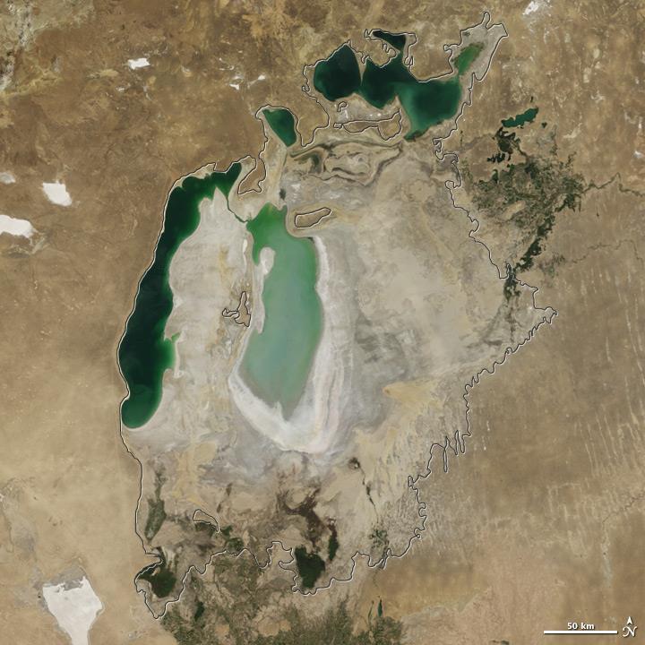
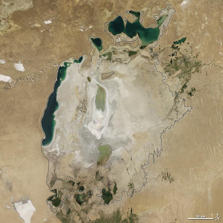
1 The Shrinking Aral Sea Practical equipment: A4 Printed copies of satellite images of Aral Sea (15 images total) A4 transparency printed with 5mm grid squares (15 copies) Equipment for producing a graph e.g. graph paper and pencil, laptop, tablet etc. The photographic sequence should ideally be printed on separate sheets. It is important that the pictures are the same size This student activity has been adapted for the STEM training workshop. It contains the contextual introduction provided for students followed by workshop suggestions for teachers. There are also links at the end of the activity sheets that might be helpful should you wish to develop a similar activity based on Vietnam or another region of the world. Context The Aral Sea was once the fourth largest lake in the world. In the 1960s the Soviet Union diverted the main rivers that flowed into the lake in order to irrigate the plains to farm cotton and other crops. These farms produce goods that bring money into the area and provide employment to the locals. However, the lake began to shrink as the amount of water entering the lake reduced. Villages that had previously survived on fishing suddenly found themselves miles away from the shore. Due to the evaporation of the water, the lake became increasingly salty killing most of the animals and fish. The dust from the dry lake bed was polluted with agricultural chemicals and caused serious health problems in people that lived nearby. More recently, heavy rains briefly refilled part of the lake but the overall level has continued to decline. Various strategies have been tried to restore some of the lake area but progress has been slow. 1. In what year did heavy rain refill part of the lake? 2. If the lake continues to shrink at its current rate, in what year will it disappear entirely? 3. Do you think this will happen? Explain your reasoning. There are many ideas to solve the problem with the lake. In one solution, the government plans to reduce the amount of water being used for irrigation to allow more to enter the lake. A cotton farmer who works on the plains nearby says: The water level in the lake is dropping, but I need to use the water to grow my crops. 1

2 A fisherman from a village that used to be on the edge of the lake says: Without water in the lake I cannot fish and my family will starve. Use information from the text, data from your graph and your own knowledge to explain the viewpoints of both people and draw a conclusion deciding if the amount of water used for irrigation should be reduced. Teachers Notes Show the animation of the shrinking lake. Ask the class: We have lots of data to collect here, if you all collect all the data from each map it will take a long time! How could we make this data collection process quicker? Hand out the printed images of the lake. There are 15 images, so split them as evenly as possible amongst the group Hand out the printed transparency sheet, one per group. Review the image of how to count squares. Count each square that is 50% or more covered by the lake. Once you have made your measurement, ask someone else in your group to make the same measurement. If your answers do not agree, discuss why this is the case and try to resolve the problem. Share the data 2
3 Produce a graph of lake area against year for and draw a straight line of best fit through the data. Discuss your results and answer the prompt questions at the start of the activity Answers to student questions: Around Yes, because extending the line of best fit on the graph shows that area of the lake reaching 0 km 2 in Farmers need the water to irrigate their crops. No, because there might be a change in water usage between now and Farmers may use more efficient methods for growing and irrigating their crops. Consider Water as a theme for the Vietnam STEM Programme Look at Wateraid links to Vietnam. Sear for Wateraid Australia and then search for Vietnam These sources might also help you think about other projects using satellite imagery 3
4 2000 4
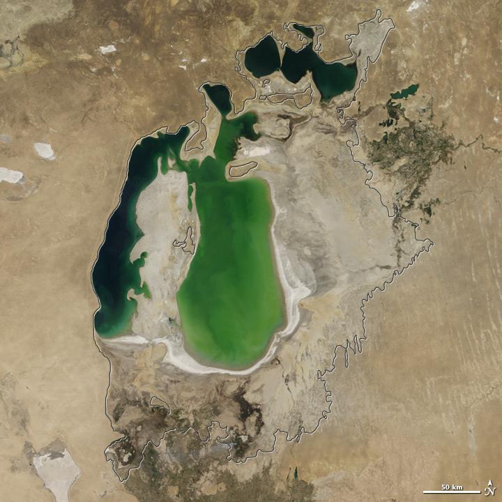
5 2001 5
6 2002 6
7 2003 7
8 2004 8
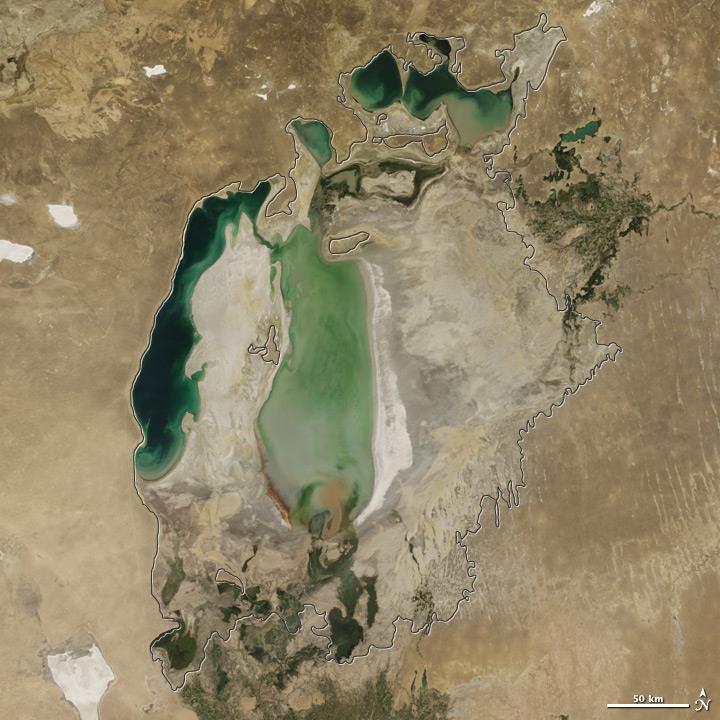
9 2005 9
10
11
12
13
14
15
16
17
18
19
After school one day, Chris s great-grandfather asked him what he
 8 The Dust Bowl R O L E P L A Y After school one day, Chris s great-grandfather asked him what he was studying in his science class. Chris began to tell him about the garden. When he described the problems
Using OS Resources - A fieldwork activity for Key Stage 2
 Using OS Resources - A fieldwork activity for Key Stage 2 Liz Spincer, Saltford CE Primary School Outline of the fieldwork project: This series of activities was designed to illustrate how Primary School
Where does the rain go?
 Where does the go? Weather Q 26 time 45 minutes (day 1) & 5 minutes (days 2 to 4) & 20 minutes (day 5) learning outcomes To: know different forms of precipitation:, hail, and snow observe changes in the
Materials needed: ISNs (students & teacher), document camera, self-reflection pages, corrected tests
, document camera, self-reflection pages, corrected tests") Science April 6-10 L.HE.05.11 Explain that the traits of an individual are influenced by both the environment and the genetics of the individual. L.HE.05.12 Distinguish between inherited and acquired traits.
Science April 6-10 L.HE.05.11 Explain that the traits of an individual are influenced by both the environment and the genetics of the individual. L.HE.05.12 Distinguish between inherited and acquired traits.
Module 2, Investigation 4: Log 1 Our coasts
 Module 2, Investigation 4: Log 1 Our coasts The coast is where the ocean meets land. Coastlines are always changing their shape. They are being worn away in some places and built up in others. Coasts can
Topic 1: Physical Features: Natural topography, Drainage system
 Topic 1: Physical Features: Natural topography, Drainage system 1 (a) Study Fig. 1, a physical map of Bangladesh. 2008 (i) Name the two rivers marked A and B. [2] (ii) Name the area marked C. [1] (iii)
Cause (or Because) Effect Possible Questions and/or Conclusions
 Effect Possible Questions and/or Conclusions") TEACHER KEY: CHART FOR CAUSE AND EFFECT READING Changes in the Salinas Economy: Understanding a cause and effect reading Question: How did the railroad change the economy of the Salinas community? Cause
TEACHER KEY: CHART FOR CAUSE AND EFFECT READING Changes in the Salinas Economy: Understanding a cause and effect reading Question: How did the railroad change the economy of the Salinas community? Cause
Changes in Texas Ecoregions Copy the questions and answers
 Changes in Texas Ecoregions Copy the questions and answers 1. What are some kinds of damage that hurricanes cause? Roads and bridges might be washed away. Trees and power lines can be knocked down. Area
World rivers investigation
 World rivers investigation Grades 3-5 This activity was designed as a companion for the music video What Does A River Want To Do?. Background What Does A River Want To Do? is a song about the countless
CLASSIFICATION AND VARIATION
 1 Living organisms Living things are made of tiny units called cells. Cells help living organisms to carry out one or more of the following life processes. Draw lines to match each process to its definition.
TIME: 45 minutes. LESSON: Curious About Clouds GRADE: 1 st SUMMARY:
 LESSON: Curious About Clouds GRADE: 1 st TIME: 45 minutes SUMMARY: Students will make observations about the weather and sky, listen to a story about weather and discuss it. Students will go outside and
CT Science Standard 4.3 Erosion Water has a major role in shaping the earth s surface. Trail Guides
 Trail Guides We have created a set of Trail Guides for use by you and your students as you explore our galleries on your field trip. The first section consists of the trail guides with teacher notes (pages
Test Booklet. Subject: SC, Grade: 05 5th Grade Science May Student name:
 Test Booklet Subject: SC, Grade: 05 5th Grade Science May 2010 Student name: Author: Ohio District: Ohio Released Tests Printed: Monday July 02, 2012 1 Scientists found fish fossils in the desert. What
My Community vs. Nunavut Weather and Climate
 My Community vs. Nunavut Content Areas Social Studies, Science, Technology Objective Students will differentiate between weather and climate. For 1 month, they will collect and graph daily temperature
Science Standard 1: Students analyze monthly precipitation and temperature records, displayed in bar charts, collected in metric units (mm).
.") Title: Precipitation Patterns across the Globe NSF GK-12 Fellow: Terry Legg Type of Lesson: STEM Grade Level(s): 4 th - 7 th grade This activity can be tailored to older, more advanced students by having
Title: Precipitation Patterns across the Globe NSF GK-12 Fellow: Terry Legg Type of Lesson: STEM Grade Level(s): 4 th - 7 th grade This activity can be tailored to older, more advanced students by having
Give 4 advantages of using ICT in the collection of data. Give. Give 4 disadvantages in the use of ICT in the collection of data
 Give 4 advantages of using ICT in the collection of data can use a handheld GPS to get accurate location information which can be used to show data linked to specific locations within a GIS can collect
Module 2 Educator s Guide Investigation 4
 Module 2 Educator s Guide Investigation 4 How do water bodies change over time? Investigation Overview Students explore how water bodies change in response to changes in weather and climate. They do experiments
View Through a Telescope Classroom Activity
 View Through a Telescope Classroom Activity The Classroom Activity introduces students to the context of a performance task, so they are not disadvantaged in demonstrating the skills the task intends to
Solving Quadratic & Higher Degree Equations
 Chapter 7 Solving Quadratic & Higher Degree Equations Sec 1. Zero Product Property Back in the third grade students were taught when they multiplied a number by zero, the product would be zero. In algebra,
How Does the Sun s Energy Cause Rain?
 1.2 Investigate 3.3 Read How Does the Sun s Energy Cause Rain? In the water-cycle simulation, you observed water change from a liquid to a gas, and then back to a liquid falling to the bottom of the container.
Lesson Six: The Role of Humans and Animals in Pollination
 Lesson Six: The Role of Humans and Animals in Pollination Grade Level: 2nd Grade Objective: The purpose of this lesson is to help students understand the important role that humans and animals play in
Catching the Rain. Lesson Objective: Students will understand how scientists measure rain by using a rain gauge in a small group setting.
 Catching the Rain Standard Addressed: Earth Science Students know how to use simple tools (e.g., thermometer, wind vane) to measure weather conditions and record changes from day to day and across the
2) Find and copy a subtitle e.g. Does anything else influence weather? 10) Name two other things that influence climate and weather.
 Find and copy a subtitle e.g. Does anything else influence weather? 10) Name two other things that influence climate and weather.") Date Understand a report on climate zones 1) What is the title of the report? 2) Find and copy a subtitle eg Does anything else influence weather? 3) What is weather? 4) What is climate? 5) What is temperature?
Date Understand a report on climate zones 1) What is the title of the report? 2) Find and copy a subtitle eg Does anything else influence weather? 3) What is weather? 4) What is climate? 5) What is temperature?
INTRODUCTION TO LESSON CLUSTER 8 Explaining Evaporation and Boiling
 INTRODUCTION TO LESSON CLUSTER 8 Explaining Evaporation and Boiling A. Lesson Cluster Goals and Lesson Objectives Goals: Students should be able to explain evaporation and boiling, both in macroscopic
Climate Change in the Inland Pacific Northwest
 80 Climate Change in the Inland Pacific Northwest Week 2 Day 4 Lesson Overview The purpose of this lesson is for students to apply and extend their previous knowledge of global climate change to a regional
Part 1: You are given the following system of two equations: x + 2y = 16 3x 4y = 2
 Solving Systems of Equations Algebraically Teacher Notes Comment: As students solve equations throughout this task, have them continue to explain each step using properties of operations or properties
RAINFORESTS. What are rainforests? Tall trees. What s the weather like? What else grows there?
 RAINFORESTS What are rainforests? Rainforests are very busy places. Half of the world s animals and plants live in rainforests. You will find birds, monkeys, apes, spiders and snakes here. A sleepy boa
Food Chains. energy: what is needed to do work or cause change
 Have you ever seen a picture that shows a little fish about to be eaten by a big fish? Sometimes the big fish has an even bigger fish behind it. This is a simple food chain. A food chain is the path of
Data Entry. Getting coordinates and attributes into our GIS
 Data Entry Getting coordinates and attributes into our GIS How we used to collect spatial data How we collect spatial data now DATA SOURCES, INPUT, AND OUTPUT Manually digitizing from image or map sources
1 Impact Evaluation: Randomized Controlled Trial (RCT)
") Introductory Applied Econometrics EEP/IAS 118 Fall 2013 Daley Kutzman Section #12 11-20-13 Warm-Up Consider the two panel data regressions below, where i indexes individuals and t indexes time in months:
Introductory Applied Econometrics EEP/IAS 118 Fall 2013 Daley Kutzman Section #12 11-20-13 Warm-Up Consider the two panel data regressions below, where i indexes individuals and t indexes time in months:
Name period date assigned date due date returned. Texas Ecoregions
 Name period date assigned date due date returned Directions: Go to the following website: https://www-k6.thinkcentral.com/epc/start.do Use the log in that is taped to the top of your laptop. If you are
Thunderstorms written by Alice Lee Folkins
 STAPLE HERE Cover Photo: A cloud-to-ground lightning strike during a nighttime thunderstorn. Taken by C. Clark. Released into the public domain by NOAA. Level D written by Alice Lee Folkins 2015 Elfrieda
Drought lesson plan ITEMS. Teachers lesson plan. Student assignments. About droughts. Real life stories. Droughts: Be prepared.
 Drought lesson plan The drought lesson plan provides teachers and students with an opportunity to investigate the Australian climate, water table and the impacts of drought through individual or classroom
DRAWING YOUR CONTINENT
 CONTINENT PROJECT PART I On the attached sheet, you will draw your own continent. Use your creativity to create a continent that is uniquely your own. Give the continent a name. When you are finished with
The sun and water cycle
 reflect The last time you took a shower, did you think about where the water came from? Sure, it came out of the showerhead, but what about before that? The water you used to wash could have spent time
Hudson River Estuary Climate Change Lesson Project. Grades 5-8 Teacher s Packet. Lesson 2. Observing Changes at Mohonk Preserve
 Grades 5-8 Teacher s Packet Lesson 2 Observing Changes at Mohonk Preserve 2 Observing Changes at Mohonk Preserve NYS Intermediate Level Science Standard 1: Analysis, Inquiry and Design/Scientific Inquiry
Mathematics Level D: Lesson 2 Representations of a Line
 Mathematics Level D: Lesson 2 Representations of a Line Targeted Student Outcomes Students graph a line specified by a linear function. Students graph a line specified by an initial value and rate of change
Participants. Participatory Mapping. Village : Date : Page : / No. Name Job Gender. Entered by. Interviewer. Author. Checked by
 Participatory Mapping Author Interviewer Entered by Checked by Original or Copy O C File name Checked by Has been written on back? Y N Has been copied? Village Participants No. Name Job Gender 1 2 3 4
Measuring Keepers S E S S I O N 1. 5 A
 S E S S I O N 1. 5 A Measuring Keepers Math Focus Points Naming, notating, and telling time to the hour on a digital and an analog clock Understanding the meaning of at least in the context of linear measurement
Your web browser (Safari 7) is out of date. For more security, comfort and. the best experience on this site: Update your browser Ignore
 is out of date. For more security, comfort and. the best experience on this site: Update your browser Ignore") Your web browser (Safari 7) is out of date. For more security, comfort and lesson the best experience on this site: Update your browser Ignore Political Borders Why are the borders of countries located
Your web browser (Safari 7) is out of date. For more security, comfort and lesson the best experience on this site: Update your browser Ignore Political Borders Why are the borders of countries located
World Space Week. Age 5-11 A FREE RESOURCE PACK FROM EDUCATIONCITY. Topical Teaching Resources. Suitability
 A FREE RESOURCE PACK FROM EDUCATIONCITY World Space Week Age 5-11 Topical Teaching Resources Suitability Free school resources by EducationCity. This may be reproduced for class use. World Space Week Topical
6. What instrument does a geologist use to record the motions produced by an earthquake?
 Name: Date: 1. Which human activity does NOT help control water runoff? A. contour plowing B. planting crops C. building flood control dams D. paving with asphalt 2. Which is NOT an effect of sewage put
NAME: DATE: GEOGRAPHY: Water and weather GEOGRAPHY. Water and weather
 GEOGRAPHY Water and weather It is not necessary to carry out all the activities contained in this unit. Please see Teachers notes for explanations, additional activities, and tips and suggestions. Theme
Developing a Community Geographical Information System (GIS) in Rural India
 in Rural India") Developing a Community Geographical Information System (GIS) in Rural India Before rushing off and describing the unique challenges of developing a small scale GIS system India I better first describe
Developing a Community Geographical Information System (GIS) in Rural India Before rushing off and describing the unique challenges of developing a small scale GIS system India I better first describe
Multiple Representations: Equations to Tables and Graphs Transcript
 Algebra l Teacher: It s good to see you again. Last time we talked about multiple representations. If we could, I would like to continue and discuss the subtle differences of multiple representations between
ADVENTURES IN WATER DEVELOPED BY LOUISVILLE WATER COMPANY
 ADVENTURES IN WATER DEVELOPED BY LOUISVILLE WATER COMPANY Tunneling for Water explains the science behind a first-of-its-kind project in the world! Louisville Water Company is the first water utility
National Center for Atmospheric Research: Climate Discovery Teacher s Guide
 Lesson Summary Students use a photo of the Bhutan glaciers in order to investigate the different effects albedo has on solar absorption. Prior Knowledge & Skills Graphing skills Data collection skills
Adaptations, independence and competition
 Adaptations, interdependence and competition Question Paper 1 Level GCSE (9-1) Subject Biology Exam Board AQA Topic 4.7 Ecology Sub-Topic Adaptations, independence and competition Difficulty Level Silver
Unit 5, Lesson 1: Interpreting Negative Numbers
 Unit 5, Lesson 1: Interpreting Negative Numbers Lesson Goals Locate rational numbers on the number line. Interpret positive and negative numbers in context. Compare rational numbers. Required Materials
Thanks. You Might Also Like. I look forward helping you focus your instruction and save time prepping.
 Thanks Connect Thank you for downloading my product. I truly appreciate your support and look forward to hearing your feedback. You can connect with me and find many free activities and strategies over
YEAR 10 SCIENCE EXAMINATION Semester 2, 2017 QUESTION AND ANSWER BOOKLET
 STUDENT NAME: TEACHER NAME: DATE: YEAR 10 SCIENCE EXAMINATION Semester 2, 2017 QUESTION AND ANSWER BOOKLET TIME ALLOWED FOR THIS PAPER: Reading time before commencing work: Working time for this paper:
Chapter 21 Southwest Asia: Harsh & Arid Lands
 Name Hour Chapter 21 Southwest Asia: Harsh & Arid Lands Essential Question: How has the physical geography of Asia influenced the development of these regions (i.e. history, population distribution, &
What Lives in the Open Ocean and Where Do They Live?
 Open Ocean 2 Concepts What are some of the organisms in the ocean? How do the physical (abiotic) properties of the ocean define what organisms live there? Standards Addressed HCPS 5.1, 5.2, & 5.3 Duration
2nd Grade. Earth's Water. Slide 1 / 111 Slide 2 / 111. Slide 3 / 111. Slide 4 / 111. Slide 5 (Answer) / 111. Slide 5 / 111. Role of Water on Earth
 / 111. Slide 5 / 111. Role of Water on Earth") Slide 1 / 111 Slide 2 / 111 2nd Grade Role of Water on Earth 2015-11-20 www.njctl.org Slide 3 / 111 Slide 4 / 111 Table of Contents: The Role of Water on Earth Earth's Water The Use of Maps Click on the
Slide 1 / 111 Slide 2 / 111 2nd Grade Role of Water on Earth 2015-11-20 www.njctl.org Slide 3 / 111 Slide 4 / 111 Table of Contents: The Role of Water on Earth Earth's Water The Use of Maps Click on the
Activity 3.2: Effigy Mounds
 3 Wisconsin s First People : Effigy Mounds Teacher Materials Background Information to Share Most effigy mound sites are found in Wisconsin, and most are within the southern half of the state. A few sites
How Geographers View the World: Human Geography. ESSENTIAL QUESTION: How does geography influence the way people live?
 How Geographers View the World: Human Geography ESSENTIAL QUESTION: How does geography influence the way people live? Geographers Think Spatially Gefffffdgfhfjgjp Guiding Question: What does it mean to
Making a tilt-o-meter & clinometer Teacher Notes
 It is difficult to predict when a volcano will erupt. Statistical probabilities can be calculated if there is an historical record of prior eruptions. Historical eruptions Massive volcanic eruptions have
(Sessions I and II)* BROWARD COUNTY ELEMENTARY SCIENCE BENCHMARK PLAN FOR PERSONAL USE
* BROWARD COUNTY ELEMENTARY SCIENCE BENCHMARK PLAN FOR PERSONAL USE") activities 19&20 What Do Plants Need? (Sessions I and II)* BROWARD COUNTY ELEMENTARY SCIENCE BENCHMARK PLAN Grade 1 Quarter 2 Activities 19 & 20 SC.A.1.1.1 The student knows that objects can be described,
activities 19&20 What Do Plants Need? (Sessions I and II)* BROWARD COUNTY ELEMENTARY SCIENCE BENCHMARK PLAN Grade 1 Quarter 2 Activities 19 & 20 SC.A.1.1.1 The student knows that objects can be described,
COMMUNITY COLLEGE OF PHILADELPHIA PHILADELPHIA, PENNSYSLVANIA. Electric Field Mapping
 COMMUNITY COLLEGE OF PHILADELPHIA PHILADELPHIA, PENNSYSLVANIA EM-1 Experiment Number: Electric Field Mapping Title: Albert Alpha Performed by: Physics 241 Physics Course: Robert Beta 005 Partners: Lab
EXPLORING MOVEMENT CLIMATE FACTS WORKSHEET 1: WEATHER WATCHERS EXPERIMENT 1. You are going to measure the wind in two ways:
 WORKSHEET : WEATHER WATCHERS EXPERIMENT You are going to measure the wind in two ways: Using a weathervane to look at wind direction Using an anemometer to compare wind speed Follow the instructions to
Did You Ever Wonder? Landforms, C52. Slow Changes on Land, C58. Fast Changes on Land, C68
 \ - i -Vt1 t _ 9 \ "» y \R Landforms, C52 Slow Changes on Land, C58 Fast Changes on Land, C68 w -4 Did You Ever Wonder? What forces shaped these rocks? Wind and rain shaped them over thousands of years.
Activity 1 Eyewitnesses to Change
 Activity 1 Eyewitnesses to Change Forces of Change >> Arctic >> Activity 1 >> Page 1 EYEWITNESSES TO CHANGE NATIVE PEOPLES OBSERVE CLIMATE CHANGES IN THE ARCTIC Living With Change Sachs Harbour, Canada
Homework Acids and Alkalis
 S2 Homework Acids and Alkalis This booklet is split into the main areas of the topic. Each main area has three different spice levels which tell you about the difficulty of the homework. Each week your
The Sun and Water Cycle
 The last time you took a shower, did you think about where the water came from? Sure, it came out of the showerhead, but what about before that? The water you used to wash could have spent time in the
Class 4J Spring Term Irian Jaya/Papua New Guinea Adapted from QCA Geography Unit 10 incorporating some elements of Unit 25
 Class 4J Spring Term 2003 Geography Irian Jaya/Papua New Guinea Geography Unit 10 incorporating some elements of Unit 25 ABOUT THE UNIT In this unit children develop ideas about a less economically developed
Ebook Code: REAU4045. The Earth & Life Science Series. Weather. Science activities for 6 to 9 year olds
 Ebook Code: REAU4045 The Earth & Life Science Series Weather Science activities for 6 to 9 year olds Written by Judy Gabrovec. Ready-Ed Publications - 2005. Published by Ready-Ed Publications (2005) P.O.
Climate Change: How it impacts Canadians and what we can do to slow it down.
 Climate Change: How it impacts Canadians and what we can do to slow it down. Lesson Overview This lesson takes stock of how climate change has already affected Canadians in geographic, economic, and cultural
Earth processes are dynamic actions that occur both on
 29 Weathering, Erosion, and Deposition R EA D I N G Earth processes are dynamic actions that occur both on the earth s surface and inside the earth. Any process that breaks down earth material, such as
ALGEBRA 1 FINAL EXAM 2006
 Overall instructions: Your Name Teacher ALGEBRA FINAL EXAM 2006 There is a mix of easier and harder problems. Don t give up if you see some questions that you don t know how to answer. Try moving on to
Ecosystem Interactions
 Ecosystem Interactions UNIT 5 Student Reader E5 Student Reader v. 9 Unit 5 Page 1 2016 KnowAtom TM Front Cover: The front cover shows a cottontail rabbit in its environment. Cottontail rabbits are very
The Physical Geographical Change of the Great Plains during the Dust Bowl (1930 s)
") The Physical Geographical Change of the Great Plains during the Dust Bowl (1930 s) Overview: This lesson shows how the Dust Bowl climate changed the physical geography of the Great Plains and forced the
The Physical Geographical Change of the Great Plains during the Dust Bowl (1930 s) Overview: This lesson shows how the Dust Bowl climate changed the physical geography of the Great Plains and forced the
Nazca Lines Famous Places
 PRE-READING A. WARM-UP QUESTIONS 1. Have you heard of the Nazca Lines? If yes, what are they? If no, what do you think they are, based on the picture? 2. Where are the Nazca Lines located? If you don t
Geography and the Early Settlement of China
 Geography and the Early Settlement of I N T E R A C T I V E S T U D E N T N O T E B O O K How did geography affect life in ancient? P R E V I E W Physical Features 1. Circle the physical features that
Why Do We Live Here? : A Historical Geographical Study of La Tabatiere, Quebec North Shore
 Why Do We Live Here? : A Historical Geographical Study of La Tabatiere, Quebec North Shore Lesson Overview Many communities and their occupants have historical connections to exploration routes and traditional
Learning Outcomes in Focus
 Contextual strand: CW Learning Outcomes in Focus Students should be able to describe and model the structure of the atom in terms of the nucleus, protons, neutrons and electrons; comparing mass and charge
GOING WITH THE FLOW (1 Hour)
") GOING WITH THE FLOW (1 Hour) Addresses NGSS Level of Difficulty: 3 Grade Range: 3-5 OVERVIEW In this activity, students use a stream table to model the processes of erosion and streambed formation. The
GOING WITH THE FLOW (1 Hour) Addresses NGSS Level of Difficulty: 3 Grade Range: 3-5 OVERVIEW In this activity, students use a stream table to model the processes of erosion and streambed formation. The
Utah Weather. Meteorology
 Utah Weather Meteorology Purpose Students will use a graphical representation of weather patters in order to visualize abstract concepts associated with the interpretation of weather data and climate variations.
Institute for Teaching through Technology and Innovative Practices Grade Five. 1 hour and 30 minutes
 Tale of a Tadpole Lesson Summary Students will use the book Tale of a Tadpole by Karen Wallace to learn about fractions and decimals. Major Topic and SOL Math SOL (2009) 5.2 Science SOL (2009) 4.5.e Reading
Discovering Planet X
 Discovering Planet X Overview: An activity exploring parallax and then simulating the discovery of Pluto with a Blink Comparator via an online interactive. Target Grade Level: 3-5 Estimated Duration: 1
Predict the effect of increased competition for abiotic and biotic resources on a food web. colored pencils graph paper ruler
 Edit File QUICK LAB Effect of Abiotic and Biotic Factors No organism exists in isolation. Organisms depend on and compete for the abiotic, or non-living, factors in its environment. For example, organisms
What Is an Acid, and How Do Acids Cause Damage? Harmful Effects of Air Pollution Are Far-Flung, a Study Finds
 What Is an Acid, and How Do Acids Cause Damage? Harmful Effects of Air Pollution Are Far-Flung, a Study Finds NEW YORK, NEW YORK Air pollution in the Northeast is not just about lakes without fish. It
Bust-A-Myth Particles of Matter and Heat Transfer. Students will use the online Research Gadget and experimentation to bust or confirm the myth:
 ACTIVITY Bust-A-Myth Particles of Matter and Heat Transfer Approximate Classroom Time: 100-150 minutes Students will use the online Research Gadget and experimentation to bust or confirm the myth: A winter
STUDY GUIDE. Exploring Geography. Chapter 1, Section 1. Terms to Know DRAWING FROM EXPERIENCE ORGANIZING YOUR THOUGHTS
 For use with textbook pages 19 22. Exploring Geography Terms to Know location A specific place on the earth (page 20) absolute location The exact spot at which a place is found on the globe (page 20) hemisphere
The impacts on the regions: Teacher notes
 The impacts on the regions: Teacher notes These resources look at the impact of climate change in 3 regions. Pupils should be split into regionally focussed groups (suggested size is four) to work through
Five Themes of Geography
 There are five themes of geography: location, place, region, movement, and humanenvironment interaction. These themes are important to geographers. The themes help them describe places. They help geographers
Student Exploration: Food Chain
 Name: Date: Student Exploration: Food Chain Vocabulary: consumer, ecosystem, equilibrium, food chain,, predator, prey, producer Prior Knowledge Questions (Do these BEFORE using the Gizmo.) The Food Chain
Unit 1, Lesson 2. What is geographic inquiry?
 What is geographic inquiry? Unit 1, Lesson 2 Understanding the way in which social scientists investigate problems will help you conduct your own investigations about problems or issues facing your community
Organism Interactions in Ecosystems
 Organism Interactions in Ecosystems Have you ever grown a plant or taken care of a pet? If so, you know they have certain needs such as water or warmth. Plants need sunlight to grow. Animals need food
DRAFT. Caption: An astronaut climbs down a lunar module on the surface of the Moon. <Insert figure 1.4 here; photograph of the surface of Mars>>
 01 Exploring Space TALKING IT OVER Throughout history, people have been fascinated by space. For a long time, people could only use their eyes to make observations of objects in the sky at night. In the
Name: Packet Due Date: Tuesday, 9/18. Science
 Name: Packet Due Date: Tuesday, 9/18 Science Module 2 Chapter 1 Phase Change Describing Phase Change at Two Scales What happened to the liquid in Titan s Lake? (NGSS Performance Expectations: MS-PS1-1;
Teacher s Pack Key Stages 1 and 2 GEOGRAPHY
 Teacher s Pack Key Stages 1 and 2 GEOGRAPHY Geography Key Stage 1 & 2 Fieldwork Worksheet Rivers: 1. Is the water fresh or salty? (test its resistance or specific gravity) FRESH 2. Do you know where the
YEAR 10 SEMESTER
 Student Name: YEAR 10 SEMESTER 1 2018 SCIENCE EXAMINATION Multiple Choice Answer Sheet Circle the letter indicating the best answer. 1 A B C D 2 A B C D 3 A B C D 4 A B C D 5 A B C D 6 A B C D 7 A B C
Where do they come from?
 Exploring Meteorite Mysteries Lesson 7 Crater Hunters Objectives Students will: observe impact craters on Earth and other solar system bodies. discuss geologic forces that have removed most of the evidence
Volcanoes - Scientist or Reporter?
 Volcanoes - Scientist or Reporter? Read your set of cards carefully and divide them into two piles: What a scientist might say when talking about a volcano What an eyewitness or newspaper reporter might
TEST B SCIENCE. First Name. Last Name. School LEVELS KEY STAGE TEST B TOTAL. Borderline check
 SCIENCE KEY STAGE 2 2004 TEST B LEVELS 3 5 PAGE 5 7 9 11 13 15 17 19 20 TOTAL Borderline check MARKS TEST B First Name Last Name School INSTRUCTIONS Read this carefully. You have 45 minutes for this test.
First Practice Test 1 Levels 6-8 Calculator not allowed
 Mathematics First Practice Test 1 Levels 6-8 Calculator not allowed First name Last name School Remember The test is 1 hour long. You must not use a calculator for any question in this test. You will need:
Land use study of Mellieha Valley
 Land use study of Mellieha Valley Fieldwork Report 1 Land use study of Mellieha Valley Location: Date: Time: Apparatus: Weather Conditions: Objectives / Aims: Geography Option Fieldwork E Gilson 2 2 Geological
Name period date assigned date due date returned. Texas Ecoregions
 Name period date assigned date due date returned Directions: Go to the following website: https://www-k6.thinkcentral.com/epc/start.do Use the log in that is taped to the top of your laptop. If you are
Working Mathematically SAMPLE ACTIVITIES. for the Stage 4 Mathematics Syllabus
 Working Mathematically SAMPLE ACTIVITIES for the Stage 4 Mathematics Syllabus NS4.2 Number Part A Activity 3-2 The size of a number The temperature felt by bare skin is determined not only by the temperature
Flooding on the Somerset Levels. ArcGIS Online
 Flooding on the Somerset Levels ArcGIS Online Using this resource This resource has been written to help teachers make use of the ArcGIS Online program. It provides; guidance on how to use the program