Earthquake prediction through Kannan-Mathematical-Model Analysis and Dobrovolsky-based clustering Technique
|
|
|
- Ashlee Lewis
- 5 years ago
- Views:
Transcription
1 Earthquake prediction through Kannan-Mathematical-Model Analysis and Dobrovolsky-based clustering Technique Jacenth Mejia 1*, Kurt Rojas 1, Nadia Valeza 1, and Al Rey Villagracia 1 1 Physics Department, De La Salle University, Taft Ave., 1004 Manila, Philippines *Corresponding Author: jacenth_mejia@dlsu.edu.ph Abstract: Earthquakes are considered to be a continuing source of hazards to the people and infrastructures, especially to those in the Pacific Ring of Fire, which includes Philippines. Seismic data from year 2011 to year 2013 were collected from the Philippine Institute of Volcanology and Seismology (PHIVOLCS) and used in this study. By dividing the Philippine archipelago into latitudinal sections and only taking the earthquakes with magnitude 4 and above into consideration, the Kannan-Mathematical-Model analysis was implemented and validated by identifying a pattern within each region based on the spatial connection theory. A clustering technique based on the formula by Dobrovolsky was used to identify the earthquake radial area of effect, and the mega thrust earthquake effect following the assumption that all nearby earthquake in the region can be an effect of a mega thrust earthquake. A prediction validation was utilized to analyze the data and the predictions which claim to be true. In this research, the Kannan Mathematical Model Analysis and Dobrovolsky-based clustering technique are seen to be related and claimed as effective techniques in predicting earthquakes in the Philippines. As a result of the model analysis, multiple data prediction was produced for the days after Earthquake probability distribution is plotted across time and surface. This model can be integrated with other models for a possible more accurate way of earthquake predictions. Key Words: Earthquake; Dobrovolsky; Mega thrust earthquake; Clustering; Prediction 1. INTRODUCTION The processes that have formed the earth that continually act on or beneath its surface such as the movement of plates in the earth s crusts is one of the continuing source of hazards to people and their structure (Besana & Ando, 2005). It goes without saying that earthquake is still an interesting, important and relevant subject matter. A major tectonic feature of the Philippine region is the Philippine Fault Zone (PFZ). The seismicity of the Central PFZ, comprised of the Guinyanga Fault, Masbate Fault and Central Leyte Fault, is defined by clusters of large and moderate earthquakes (Department of Regional Development and Environment Executive Secretariat for Economic and Social Affairs Organization of American States, 1991). One of the events that exemplify the destructive prowess of earthquakes is the July 16, a 7.7 magnitude earthquake triggered by a fault zone movement. It caused 1,677 lives accompanied by extensive damages in the central and northern Luzon (Rantucci, 1994). It is therefore beneficial to develop pattern analysis and earthquake models to predict earthquakes. Aside from developing our own method to predict earthquakes in the Philippines, it is equally important to implement or test other methods which were previously tested only on foreign lands. We tested for the validity of the model when applied to the data of the Philippines. Present prediction methods uses following categories of precursors: land deformation, tilt and strain, seismic activity, geo-electricity, SEE-I-008 1
2 geomagnetism, oil flow, micro-seismicity, resistivity, radon emission and Underground Water and Hot Springs (Rikitake & Hamada, 2002). Although widely used in short term earthquake prediction, the use of these precursors is claimed to be still empirical to a large extent. This is mainly due to the many difficulties in understanding the physics of its entirety (Patella, Tramacere, & Di Maio, 1997). In this study some of these played a part in the clustering of earthquakes. The Kannan-Mathematical-Model analysis was implemented to identify a pattern within each region based on spatial connection theory: earthquakes occurring within a region are related to one another (Kannan, 2013). A Clustering technique was developed and used based on the Dobrovolsky earthquake radial area of effect and the megathrustaftershock effect The result of the accumulation of extensive researches on the geological phenomenon that have been performed up to this date has been translated into form that are accessible to non-scientists (Besana & Ando, 2005). The knowledge and results simplified to be understood by non-scientists proves to be remarkably important in reducing damages due to earthquake. It plays a significant role in earthquake preparedness and structural engineering and architecture. This paper is organized as follows. In 2, we present the ideas, crucial equations and the methods done in the study. Finally, in 3 we present the calculation results, analysis and interpretation. 2. METHODOLOGY Significant amount of earthquake data exists in global earthquake databases such as those by the Philippine Institute of Volcanology and Seismology (PHIVOLCS). For this research, the data used is the 2011 to 2013 earthquakes observed by PHIVOLCS (Philippine Institute of Volcanology and Seismology, n.d.). Also only earthquakes of magnitude 4 and above were considered. There are two main parts of methodology in this study. First is the clustering. Due to the many active fault zones in the Philippines, it was found to be very challenging to cluster the earthquakes when the basis is the fault zone. An alternate solution to this comes from the prominence of the role played by earth current anomalous variations prior to earthquakes. The currents can be revealed on the earth s free surface proposes a physical model, capable of explaining the formation anomalous earth current fields prior to earthquakes (Patella et al., 1997). Radon is one of the geophysical forerunners of earthquake prediction. Being a main component of the physical mechanism of seismogenic electric field generation, the area covered by the irregular fluxes of radon is expected to be of the same order of magnitude as the areas covered by the seismogenic electric field. Consequently, the measured geochemical effects of radon before earthquakes coincide and are completely identical to the affected zone calculated by Dobrovolsky (Saradijian & Akboondzadeh, 2011). With this in mind, the Dobrovolsky equation for radial area of effect was used as a basis and shown in Eq. 1. The magnitude used in the equation is the average magnitude of those earthquakes within the region. Radius = M (Eq.1) where: M is the average magnitude On 2012, a magnitude 7.6 earthquake ruptured beneath the sea floor of the Philippine Trench. In the wake of the main shock, sensors detected a flurry of 110 aftershocks. A minor revision was made to the Dobrovolsky equation when the idea of the megathrust effect was introduce into the equation. The revised Dobrovolsky Equation changed the magnitude into twice of the average magnitude. The idea was that along that particular region, the earthquakes were a product of a megathrust earthquake. The revised Dobrovolsky equation, we will now call the Dobrovolsky-Megathrust Radius Equation, is shown in Eq. 2. Radius = (2M) where: M is the average magnitude (Eq.2) A latitudal clustering was introduced to find the geometric center using Eq. 3 and Eq. 4 which was assumed to be the epicenter of the Megathrust earthquake. All earthquake data that are inside the latitudal clustering contributed to the calculation of the average magnitude. The earthquake data was filtered with the use of the calculated area of effect using the Dobrovolsky-Megathrust Radius Equation in such a way that only the earthquakes inside the area were taken. Average Latitude = Latitude (Eq.3) n Average Longitude = Longitude n n = number of data points (Eq.4) The second part was the application of the Kannan-Mathematical Model to the filtered Philippine earthquake data. The theory basis of the SEE-I-008 2
.")
3 Kannan-Mathematical Model is the spatial connection theory. The spatial connection theory is based on the assumption that earthquakes are related to previous earthquakes that occurred within a fault zone or region (Kannan, 2013). This theory is very significant and related to the subject because Philippines contains so many fault zones. Mathematical functions utilized in this research were the Poisson Range Identifier function (PRI), poisson s distribution, and reverse poisson s distribution. The PRI function utilizes the data from the spatial connection model to derive PRI values for each earthquake zone. Then, a distance factor was derived using the Poisson s distribution. The prediction was carried out by using the reverse Poisson s distribution and the distance factor for the earthquake zone (Kannan, 2013). The PRI equation is shown in Eq. 5. PRI = (X1 TL2) [(Cos(theta) X2 TL1)] (Eq. 5) X1 = distance between point 1 and 2 X2 = distance between point 2 and 3 TL1 = time lag between 1 and 2 TL2 = time lag between 2 and 3 To validate the theory, the models were built for the first half of the data and prediction were developed. Then the models for the second half was built, validating the predictions from the initial models (Rantucci, 1994). After validation of the model, a prediction was developed using the second half of the data to conclude this research. The application of the latitudal clustering / data sorting, geometric center and Dobrovolsky- Megathrust Radius calculation was coded in a FORTRAN program and was the first program to be run in the whole calculation process. Time lag calculation, which is an essential factor in PRI calculation, was conducted in Microsoft Excel. The raw data was in latitude and longitude and was processed with the Haversine Formula (shown in Eq. 6) integrated in a FORTRAN program to find the distance between two points a specific requirement for using the PRI equation. The angle between two spatial connections was calculated with the Cosine law (Eq. 7) integrated in a FORTRAN program automated for large data points. The PRI calculation was also calculated with an automated FORTRAN program. Using the PRI computed values, the mean, standard deviation, variance and cumulative was calculated using Microsoft Excel excluding the outliers (data that gives a PRI value greater than 10). These variables were used to find the distance factor. The distance factor was calculated using the Poisson s distribution function (Eq. 8) a= (sin ( lat 2 ))2 + cos(lat1) * cos(lat2) *(sin( lon)) 2 distance=r*(2*atan2 (( a), ( 1-a )) (Eq. 6) lat = Latitude 2 Latitude 1 lon = Longitude 2 Longitude 1 Lat1 = Latitude 1 Lat2 = Latitude 2 R = radius of earth = 6371 km Atan2 = arc tan with 2 arguments θ = cos 1 ( a2 +b 2 c 2 ) (Eq. 7) 2ab θ = Angle between line 1 and 2 a = line length from point 1 to 2 b = line length from point 2 to 3 c = line length from point 1 to 3 DF = poisson dist(pri, mean, cu) (Eq. 8) PRI = PRI values Mean = PRI mean Cu = PRI cumulative or sum 3. RESULTS AND DISCUSSION Using the data gathered from PHILVOCS in the year 2011, 2012 and 2013, the regional sorting program that uses the Dobrovolsky-Megathrust equation was run. A Google earth model is shown in Fig. 1. Earthquake Megathrust epicenter, Earthquake epicenters included in radial region, and Earthquakes used in the radius calculation but not within radius was marked Blue, Red, and Yellow, respectively. SEE-I-008 3
 Earthquake")
 Earthquake latitude 7-9 (f)")
 Earthquake latitude19-21 Figure")

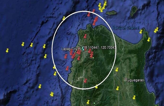
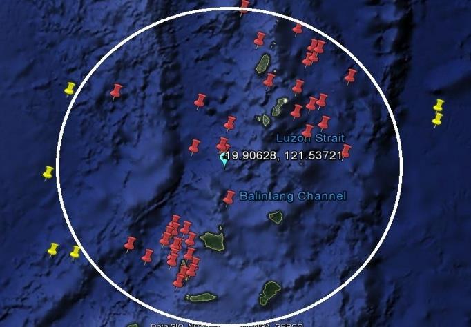
4 (a) Earthquake clustered using geometric center calculated from latitude 5-7 (e) Earthquake clustered using geometric center calculated from latitude (b) Earthquake clustered using geometric center calculated from latitude 7-9 (f) Earthquake clustered using geometric center calculated from latitude (c) Earthquake clustered using geometric center calculated from latitude 9-11 (g) Earthquake clustered using geometric center calculated from latitude19-21 Figure 1. Clustered Earthquake Data points (d) Earthquake clustered using geometric center calculated from latitude SEE-I-008 4

5 Table 1. Calculated Poisson Range Identifier Latitude initial Latitude Final Mean PRI Cumulative PRI Data calculation for PRI value and distance factor for the 1 st half of the data for each cluster was calculated. The predictions were validated by using the 1 st half of the data for each cluster to predict the data presented in the 2 nd half. In the first run of calculations, a big number of predictions per cluster was seen but then, through setting a margin of error in predicting the data, only a number was considered as a valid prediction. The predictions were then proved to be true. Figure 2. Sample plot of probabilities of earthquake occurrence within 30 days after the October 15, 2012 in South Cotabato. (scale: green=high, orange=mid, yellow=low) In this research, a margin of error for the distance, time lag and theta were set that for any prediction that coincided within the parameters will prove that the prediction is true. The distance s parameter is 10 km, time lag s parameter is 10 days and theta or the angle was also set into 10 degrees. Results showed that there is an identifiable pattern in predicting earthquakes in the Philippines. The Kannan-Mathematical model analysis and the Dobrovolsky clustering technique is therefore related and an adequate method in predicting earthquakes in the Philippines. Table 2. Predictions that coincided within the margin of error. Cluster Latitude Longitude Timelag Through the calculations made in the data, the clusters have shown a number of predictions that coincided within the parameters. Table 2 shows some of the predictions that coincided with the margin of error. 4. CONCLUSIONS AND RECOMMENDATION The performed research validated the Kannan-Mathematical model analysis, together with the Dobrovolsky clustering technique, as a method for predicting earthquakes. This research can be improved by changing the assumptions; such as considering the earthquakes that occur with a magnitude below 4.0 and by having different divisions of the area to be studied. The margin for error set for proving the prediction to be valid may also be varied to show other results that can possibly coincide with the set parameters: distance, time lag, and theta. 5. REFERENCES Besana, G. M., & Ando, M. (2005). The central Philippine Fault Zone: Location of great earthquakes, slow events,. Earth Planets Space, Chopde, N. R., & Nichat, M. (2013). Landmark Based Shortest Path Detection by Using A* and Haversine Formula. International Journal of Innovative Research in Computer and Communication Engineering, Department of Regional Development and Environment Executive Secretariat for Economic and Social Affairs Organization of American States. (1991). Primer on Natural Hazard Management in Integrated Regional Development Planning. Washington, D.C. Kannan, S. (2013). Innovative Mathematical Model for earthquake Prediction. Engineering Failure Analysis, SEE-I-008 5
6 Patella, D., Tramacere, A., & Di Maio, R. (1997). Modelling earth current precursorsin earthquake prediction. Annali di geofisica, Philippine Institute of Volcanology and Seismology. (n.d.). Latest Earthquake Information. Retrieved July 20, 2014, from PHIVOLCS: _SOEPD/EQLatest.html Rantucci, G. (1994). Geological disasters in the Philippines : The July 1990 earthquake and the June 1991 eruption of Mount Pinatubo. Rome Rikitake, T., & Hamada, K. (2002). Earthquake Prediction. In R. A. Meyers, Encyclopedia of Physical Science and Technology (pp ). San Diego: Academic Press. Saradijian, M. R., & Akboondzadeh, M. (2011). Prediction of the date, magnitude and affected area of impending strong earthquakes using integration of multi precursors earthquake parameters. Natural Hazards and Earth System Science, SEE-I-008 6
RELOCATION OF LARGE EARTHQUAKES ALONG THE PHILIPPINE FAULT ZONE AND THEIR FAULT PLANES
 RELOCATION OF LARGE EARTHQUAKES ALONG THE PHILIPPINE FAULT ZONE AND THEIR FAULT PLANES Rey M. Lumbang MEE12608 Supervisor: Nobuo Hurukawa ABSTRACT We relocated large magnitude (Mw 7.0) earthquakes that
EARTHQUAKE SOURCE PARAMETERS FOR SUBDUCTION ZONE EVENTS CAUSING TSUNAMIS IN AND AROUND THE PHILIPPINES
 EARTHQUAKE SOURCE PARAMETERS FOR SUBDUCTION ZONE EVENTS CAUSING TSUNAMIS IN AND AROUND THE PHILIPPINES Joan Cruz SALCEDO Supervisor: Tatsuhiko HARA MEE09186 ABSTRACT We have made a set of earthquake source
Sendai Earthquake NE Japan March 11, Some explanatory slides Bob Stern, Dave Scholl, others updated March
 Sendai Earthquake NE Japan March 11, 2011 Some explanatory slides Bob Stern, Dave Scholl, others updated March 14 2011 Earth has 11 large plates and many more smaller ones. Plates are 100-200 km thick
Earthquakes. Earthquake Magnitudes 10/1/2013. Environmental Geology Chapter 8 Earthquakes and Related Phenomena
 Environmental Geology Chapter 8 Earthquakes and Related Phenomena Fall 2013 Northridge 1994 Kobe 1995 Mexico City 1985 China 2008 Earthquakes Earthquake Magnitudes Earthquake Magnitudes Richter Magnitude
What is an Earthquake?
 Earthquakes What is an Earthquake? Earthquake - sometimes violent shaking of ground caused by movement of Earth s tectonic plates; creates seismic waves Often followed by smaller earthquakes (aftershocks);
Earthquakes and Earthquake Hazards Earth - Chapter 11 Stan Hatfield Southwestern Illinois College
 Earthquakes and Earthquake Hazards Earth - Chapter 11 Stan Hatfield Southwestern Illinois College What Is an Earthquake? An earthquake is the vibration of Earth, produced by the rapid release of energy.
Earthquakes. Earthquakes and Plate Tectonics. Earthquakes and Plate Tectonics. Chapter 6 Modern Earth Science. Modern Earth Science. Section 6.
 Earthquakes Chapter 6 Modern Earth Science Earthquakes and Plate Tectonics Section 6.1 Modern Earth Science Earthquakes and Plate Tectonics Earthquakes are the result of stresses in Earth s s lithosphere.
Running Head: JAPANESE TSUNAMI 1. Geological Perspective of the Japanese Tsunami
 Running Head: JAPANESE TSUNAMI 1 Geological Perspective of the Japanese Tsunami JAPANESE TSUNAMI 2 JAPANESE TSUNAMI 3 Abstract Humanity is characterized with flaws, so is planet earth. Earthquakes shake
Earthquakes Chapter 19
 Earthquakes Chapter 19 Does not contain complete lecture notes. What is an earthquake An earthquake is the vibration of Earth produced by the rapid release of energy Energy released radiates in all directions
Tectonic Processes and Hazards Enquiry Question 1: Why are some locations more at risk from tectonic hazards?
 Tectonic Processes and Hazards Enquiry Question 1: Why are some locations more at risk from tectonic hazards? Key words Basalt Andesite Rhyolite Benioff Zone Subduction zone Crustal fracturing Definition
Earthquake. What is it? Can we predict it?
 Earthquake What is it? Can we predict it? What is an earthquake? Earthquake is the vibration (shaking) and/or displacement of the ground produced by the sudden release of energy. Rocks under stress accumulate
I. Locations of Earthquakes. Announcements. Earthquakes Ch. 5. video Northridge, California earthquake, lecture on Chapter 5 Earthquakes!
 51-100-21 Environmental Geology Summer 2006 Tuesday & Thursday 6-9:20 p.m. Dr. Beyer Earthquakes Ch. 5 I. Locations of Earthquakes II. Earthquake Processes III. Effects of Earthquakes IV. Earthquake Risk
Once you have opened the website with the link provided choose a force: Earthquakes
 Name: Once you have opened the website with the link provided choose a force: Earthquakes When do earthquakes happen? On the upper left menu, choose number 1. Read What is an Earthquake? Earthquakes happen
Earthquake Source. Kazuki Koketsu. Special Session: Great East Japan (Tohoku) Earthquake. Earthquake Research Institute, University of Tokyo
 Earthquake. Earthquake Research Institute, University of Tokyo") 2012/9/24 17:20-17:35 WCEE SS24.4 Special Session: Great East Japan (Tohoku) Earthquake Earthquake Source Kazuki Koketsu Earthquake Research Institute, University of Tokyo 1 Names and features of the earthquake
2012/9/24 17:20-17:35 WCEE SS24.4 Special Session: Great East Japan (Tohoku) Earthquake Earthquake Source Kazuki Koketsu Earthquake Research Institute, University of Tokyo 1 Names and features of the earthquake
Earthquakes. Building Earth s Surface, Part 2. Science 330 Summer What is an earthquake?
 Earthquakes Building Earth s Surface, Part 2 Science 330 Summer 2005 What is an earthquake? An earthquake is the vibration of Earth produced by the rapid release of energy Energy released radiates in all
UGRC 144 Science and Technology in Our Lives/Geohazards
 UGRC 144 Science and Technology in Our Lives/Geohazards Session 3 Understanding Earthquakes and Earthquake Hazards Lecturer: Dr. Patrick Asamoah Sakyi Department of Earth Science, UG Contact Information:
LECTURE #5: Plate Tectonics: Boundaries & Earthquake Science
 GEOL 0820 Ramsey Natural Disasters Spring, 2018 LECTURE #5: Plate Tectonics: Boundaries & Earthquake Science Date: 23 January 2018 I. Reminder: Exam #1 is scheduled for Feb 1st one week from Thursday o
Dynamic Earth A B1. Which type of plate boundary is located at the Jordan Fault? (1) divergent (3) convergent (2) subduction (4) transform
 divergent (3) convergent (2) subduction (4) transform") Dynamic Earth A B1 1. The edges of most lithospheric plates are characterized by (1) reversed magnetic orientation (2) unusually rapid radioactive decay (3) frequent volcanic activity (4) low P-wave and
Dynamic Earth A B1 1. The edges of most lithospheric plates are characterized by (1) reversed magnetic orientation (2) unusually rapid radioactive decay (3) frequent volcanic activity (4) low P-wave and
Plates & Boundaries The earth's continents are constantly moving due to the motions of the tectonic plates.
 Plates & Boundaries The earth's continents are constantly moving due to the motions of the tectonic plates. As you can see, some of the plates contain continents and others are mostly under the ocean.
Section Forces Within Earth. 8 th Grade Earth & Space Science - Class Notes
 Section 19.1 - Forces Within Earth 8 th Grade Earth & Space Science - Class Notes Stress and Strain Stress - is the total force acting on crustal rocks per unit of area (cause) Strain deformation of materials
San Andreas Movie Can It Happen?
 San Andreas Movie Can It Happen? Learning Objectives (LO) Lecture 14: Faults and Quakes Read: Chapter 10 and 11 Homework #12 due Thursday 12pm What we ll learn today:! 1. Compare strike-slip to dip-slip
Aftershock From Wikipedia, the free encyclopedia
 Page 1 of 5 Aftershock From Wikipedia, the free encyclopedia An aftershock is a smaller earthquake that occurs after a previous large earthquake, in the same area of the main shock. If an aftershock is
The Structure of the Earth and Plate Tectonics
 The Structure of the Earth and Plate Tectonics Agree or Disagree? 1. The Earth if made up of 4 different layers. 2. The crust (where we live) can be made of either less dense continental crust or the more
Surface Anomalies Prior to Earthquakes
 Surface Anomalies Prior to Earthquakes Habibeh Valizadeh, Shattri B. Mansor Husaini Omar and Farid Azad Department of Civil Engineering Universiti Putra Malaysia Serdang, Selangor Malaysia shattri@eng.upm.edu.my
TSUNAMI AND EARTHQUAKE ACTIVITY IN INDONESIA *
 LOCAL TSUNAMI WARNING AND MITIGATION TSUNAMI AND EARTHQUAKE ACTIVITY IN INDONESIA * Nanang T. Puspito Department of Geophysics and Meteorology, Institute of Technology Bandung (ITB) Address: Jalan Ganeca
Elastic Rebound Theory
 Earthquakes Elastic Rebound Theory Earthquakes occur when strain exceeds the strength of the rock and the rock fractures. The arrival of earthquakes waves is recorded by a seismograph. The amplitude of
INTRODUCTION TO EARTHQUAKES
 INTRODUCTION TO EARTHQUAKES Seismology = Study of earthquakes Seismologists = Scientists who study earthquakes Earthquake = Trembling or shaking of the earth s surface, usually as a result of the movement
Progress Report: Sentinel Asia Success Story in the Philippines
 Progress Report: Sentinel Asia Success Story in the Philippines 3 rd Joint Project Team Meeting on the Sentinel Asia STEP-2 July 6-8, 2010 Hyatt Hotel, Manila, Philippines Renato U. Solidum Jr. Director
Philippines: Mining or Food?
 Philippines: Mining or Food? by Robert Goodland and Clive Wicks for The Working Group on Mining in the Philippines Annex G: Geohazards and Earthquakes1 in the Philippines Sustainable development is development
Earthquakes and Earth s Interior
 - What are Earthquakes? Earthquakes and Earth s Interior - The shaking or trembling caused by the sudden release of energy - Usually associated with faulting or breaking of rocks - Continuing adjustment
Earthquakes Earth, 9th edition, Chapter 11 Key Concepts What is an earthquake? Earthquake focus and epicenter What is an earthquake?
 1 2 3 4 5 6 7 8 9 10 Earthquakes Earth, 9 th edition, Chapter 11 Key Concepts Earthquake basics. "" and locating earthquakes.. Destruction resulting from earthquakes. Predicting earthquakes. Earthquakes
Magnitude 7.1 PHILIPPINES
 A magnitude 7.1 earthquake struck in the southeastern Philippines just after 8 am local time Tuesday morning killing 82 people and reducing a 17 th century church to rubble. Offices and schools were closed
Seismic Activity and Crustal Deformation after the 2011 Off the Pacific Coast of Tohoku Earthquake
 J-RAPID Symposium March 6-7, 2013 Seismic Activity and Crustal Deformation after the 2011 Off the Pacific Coast of Tohoku Earthquake Y. Honkura Tokyo Institute of Technology Japan Science and Technology
General Oceanography Geology 105 Expedition 8 Plate Boundaries Beneath the Sea Complete by Thursday at 11:00 PM
 General Oceanography Geology 105 Expedition 8 Plate Boundaries Beneath the Sea Complete by Thursday at 11:00 PM Name Expedition Objectives Learn about the types of plate boundaries and their key characteristics
Chapter Introduction Lesson 1 Earthquakes Lesson 2 Volcanoes Chapter Wrap-Up
 Chapter Introduction Lesson 1 Earthquakes Lesson 2 Volcanoes Chapter Wrap-Up What causes earthquakes and volcanic eruptions? What do you think? Before you begin, decide if you agree or disagree with each
AIM: What are the features of Earthquakes and where are they located? Do Now: What are some words that are associated with earthquakes?
 Notepack # 11 November 8, 201 AIM: What are the features of Earthquakes and where are they located? Do Now: What are some words that are associated with earthquakes? What are Earthquakes? The shaking or
Earthquakes & Volcanoes
 Earthquakes & Volcanoes Geology - the study of solid Earth, the rocks of which it is composed, and the processes by which they change geo = Earth; ology = study of Earth s Layers Plate Tectonics - the
TEGAM s Connection to the EarthScope Project
 TEGAM s Connection to the EarthScope Project Introduction The EarthScope Project is an undertaking funded by the National Science Foundation in partnership with the United States Geological Survey and
Earth Science Ch. 5.1 Ch. 5 Vocabulary List Lesson 1: Earth s Moving Plates
 Earth Science Ch. 5.1 Ch. 5 Vocabulary List Lesson 1: Earth s Moving Plates Name # Teacher + 22 Use your textbook s glossary & index to help you define the following words. (2 points each) & Sketch (optional)
crustal structure experiment beneath Wairarapa - Wellington area: results from SAHKE
 crustal structure experiment beneath Wairarapa - Wellington area: results from SAHKE Tim Stern and SAHKE team* * VUW, GNS, University of Southern California, University of Tokyo(Japan) SAHKE = Seismic
Mathematical models for estimating earthquake casualties and damage cost through regression analysis using matrices
 Journal of Physics: Conference Series OPEN ACCESS Mathematical models for estimating earthquake casualties and damage cost through regression analysis using matrices To cite this article: J D Urrutia et
BRIEFING MEMO ON RESERVOIR TRIGGERED SEISMICITY (RTS)
") BRIEFING MEMO ON RESERVOIR TRIGGERED SEISMICITY (RTS) 1. General. The issue of reservoir-triggered seismicity (RTS) has been controversial, and hotly debated, for many decades. There has been general recognition
BRIEFING MEMO ON RESERVOIR TRIGGERED SEISMICITY (RTS) 1. General. The issue of reservoir-triggered seismicity (RTS) has been controversial, and hotly debated, for many decades. There has been general recognition
Pre-earthquake activity in North-Iceland Ragnar Stefánsson 1, Gunnar B. Guðmundsson 2, and Þórunn Skaftadóttir 2
 International Workshop on Earthquakes in North Iceland Húsavík, North Iceland, 31 May - 3 June 2016 Pre-earthquake activity in North-Iceland Ragnar Stefánsson 1, Gunnar B. Guðmundsson 2, and Þórunn Skaftadóttir
S. Toda, S. Okada, D. Ishimura, and Y. Niwa International Research Institute of Disaster Science, Tohoku University, Japan
 The first surface-rupturing earthquake in 20 years on a HERP major active fault: Mw=6.2 2014 Nagano, Japan, event along the Itoigawa-Shizuoka Tectonic Line is not characteristic S. Toda, S. Okada, D. Ishimura,
Continental Drift to Plate Tectonics: From Hypothesis to Theory
 Continental Drift to Plate Tectonics: From Hypothesis to Theory 1 Key Understandings Internal structure of the earth/structure of the crust. Difference between continental drift & plate tectonics. Evidence
Effect of an outer-rise earthquake on seismic cycle of large interplate earthquakes estimated from an instability model based on friction mechanics
 Effect of an outer-rise earthquake on seismic cycle of large interplate earthquakes estimated from an instability model based on friction mechanics Naoyuki Kato (1) and Tomowo Hirasawa (2) (1) Geological
Oklahoma Earthquakes: Trends and Underlying Causes. Jeremy Boak, Oklahoma Geological Survey October 21, 2016
 Oklahoma Earthquakes: Trends and Underlying Causes Jeremy Boak, Oklahoma Geological Survey jboak@ou.edu October 21, 2016 1 The Oklahoma Geological Survey is a state agency for research and public service
SEISMIC HAZARD ASSESSMENT FOR JAPAN AFTER THE 2011 TOHOKU-OKI MEGA-THRUST EARTHQUAKE (Mw9.0)
") Proceedings of the International Symposium on Engineering Lessons Learned from the 2011 Great East Japan Earthquake, March 1-4, 2012, Tokyo, Japan SEISMIC HAZARD ASSESSMENT FOR JAPAN AFTER THE 2011 TOHOKU-OKI
Proceedings of the International Symposium on Engineering Lessons Learned from the 2011 Great East Japan Earthquake, March 1-4, 2012, Tokyo, Japan SEISMIC HAZARD ASSESSMENT FOR JAPAN AFTER THE 2011 TOHOKU-OKI
Earthquakes and Earth s Chapter. Interior
 Earthquakes and Earth s Chapter Interior 8.1 What Is an Earthquake? An earthquake is the vibration of Earth produced by the rapid release of energy Focus and Epicenter Focus is the point within Earth
PROBABILISTIC SEISMIC HAZARD MAPS AT GROUND SURFACE IN JAPAN BASED ON SITE EFFECTS ESTIMATED FROM OBSERVED STRONG-MOTION RECORDS
 13 th World Conference on Earthquake Engineering Vancouver, B.C., Canada August 1-6, 2004 Paper No. 3488 PROBABILISTIC SEISMIC HAZARD MAPS AT GROUND SURFACE IN JAPAN BASED ON SITE EFFECTS ESTIMATED FROM
Southern California Earthquake Center Collaboratory for the Study of Earthquake Predictability (CSEP) Thomas H. Jordan
 Thomas H. Jordan") Southern California Earthquake Center Collaboratory for the Study of Earthquake Predictability (CSEP) Thomas H. Jordan SCEC Director & Professor, University of Southern California 5th Joint Meeting of
Southern California Earthquake Center Collaboratory for the Study of Earthquake Predictability (CSEP) Thomas H. Jordan SCEC Director & Professor, University of Southern California 5th Joint Meeting of
FORCES ON EARTH. An investigation into how Newton s Laws of Motion are applied to the tectonic activity on Earth.
 FORCES ON EARTH An investigation into how Newton s Laws of Motion are applied to the tectonic activity on Earth. GEOLOGY Geologists scientists who study the forces that make and shape the Earth Geologists
Kind of plate boundary (convergent or divergent?)
") 19B Plate Tectonics What is plate tectonics? Earth s crust plus the upper mantle forms the lithosphere. Earth s lithosphere is broken in a number of different pieces. How these pieces move and interact
19B Plate Tectonics What is plate tectonics? Earth s crust plus the upper mantle forms the lithosphere. Earth s lithosphere is broken in a number of different pieces. How these pieces move and interact
General Oceanography Geology 105 Expedition 8 Plate Boundaries Beneath the Sea
 General Oceanography Geology 105 Expedition 8 Plate Boundaries Beneath the Sea Name Not attempting to answer questions on expeditions will result in point deductions on course workbook (two or more blank
The Structure of the Earth and Plate Tectonics
 The Structure of the Earth and Plate Tectonics Structure of the Earth The Earth is made up of 4 main layers: Inner Core Outer Core Mantle Crust Crust Mantle Outer core Inner core The Crust This is where
Possible Abnormal Phenomenon of the Atmospheric Water Vapor before Hengchun Earthquake
 PIERS ONLINE, VOL. 6, NO. 1, 2010 21 Possible Abnormal Phenomenon of the Atmospheric Water Vapor before Hengchun Earthquake Yuntao Ma 1, 3, Yiyang Zhao 1, Shanjun Liu 1, and Lixin Wu 1, 2 1 Institute for
Moho (Mohorovicic discontinuity) - boundary between crust and mantle
 - boundary between crust and mantle") Earth Layers Dynamic Crust Unit Notes Continental crust is thicker than oceanic crust Continental Crust Thicker Less Dense Made of Granite Oceanic Crust Thinner More Dense Made of Basalt Moho (Mohorovicic
Earth Layers Dynamic Crust Unit Notes Continental crust is thicker than oceanic crust Continental Crust Thicker Less Dense Made of Granite Oceanic Crust Thinner More Dense Made of Basalt Moho (Mohorovicic
focus seismic waves Earthquakes
 LESSON 3 fault line All of a sudden, Earth s crust shakes and solid land shifts. What causes an earthquake? How can an earthquake be measured? Read this selection to learn about earthquakes. Earthquakes
A GLOBAL MODEL FOR AFTERSHOCK BEHAVIOUR
 A GLOBAL MODEL FOR AFTERSHOCK BEHAVIOUR Annemarie CHRISTOPHERSEN 1 And Euan G C SMITH 2 SUMMARY This paper considers the distribution of aftershocks in space, abundance, magnitude and time. Investigations
Disclaimer. This report was compiled by an ADRC visiting researcher (VR) from ADRC member countries.
 from ADRC member countries.") Disclaimer This report was compiled by an ADRC visiting researcher (VR) from ADRC member countries. The views expressed in the report do not necessarily reflect the views of the ADRC. The boundaries and
Disclaimer This report was compiled by an ADRC visiting researcher (VR) from ADRC member countries. The views expressed in the report do not necessarily reflect the views of the ADRC. The boundaries and
Section 19.1: Forces Within Earth Section 19.2: Seismic Waves and Earth s Interior Section 19.3: Measuring and Locating.
 CH Earthquakes Section 19.1: Forces Within Earth Section 19.2: Seismic Waves and Earth s Interior Section 19.3: Measuring and Locating Earthquakes Section 19.4: Earthquakes and Society Section 19.1 Forces
Tsunami waves swept away houses and cars in northern Japan and pushed ships aground.
 Japan was struck by a magnitude 8.9 earthquake off its northeastern coast Friday. This is one of the largest earthquakes that Japan has ever experienced. In downtown Tokyo, large buildings shook violently
EARTHQUAKE PREDICTION BY USING GIS
 EARTHQUAKE PREDICTION BY USING GIS Prepared by: Mansoor Jehangir -A CRP 514 Term Project- -Submitted to : Dr. Baqer Al-Ramadan- INTRODUCTION Natural hazards and catastrophes are recurring phenomenon which
Name Date Class. radiate in all directions, carrying some of the. of plate boundaries have different usual patterns of.
 Chapter Outline Earthquakes CHAPTER 6 Lesson 1: Earthquakes and Plate Boundaries A. What is an earthquake? 1. A(n) is the rupture and sudden movement of rocks along a fault. A fault is a fracture surface
Plate Tectonics. By Destiny, Jarrek, Kaidence, and Autumn
 Plate Tectonics By Destiny, Jarrek, Kaidence, and Autumn .The Denali Fault and San Andreas Fault - The San Andreas Fault is a continental transform fault that extends roughly 1300 km (810 miles) through
Ground displacement in a fault zone in the presence of asperities
 BOLLETTINO DI GEOFISICA TEORICA ED APPLICATA VOL. 40, N. 2, pp. 95-110; JUNE 2000 Ground displacement in a fault zone in the presence of asperities S. SANTINI (1),A.PIOMBO (2) and M. DRAGONI (2) (1) Istituto
Chapter 2 Plate Tectonics and the Ocean Floor
 Chapter 2 Plate Tectonics and the Ocean Floor Matching. Match the term or person with the appropriate phrase. You may use each answer once, more than once or not at all. 1. hydrothermal vents A. convergent
Triggering of great earthquakes: calculation and analysis of combined tidal effect of the Moon and Sun
 IOP Conference Series: Earth and Environmental Science PAPER OPEN ACCESS Triggering of great earthquakes: calculation and analysis of combined tidal effect of the Moon and Sun Related content - INTERACTION
Widespread Ground Motion Distribution Caused by Rupture Directivity during the 2015 Gorkha, Nepal Earthquake
 Widespread Ground Motion Distribution Caused by Rupture Directivity during the 2015 Gorkha, Nepal Earthquake Kazuki Koketsu 1, Hiroe Miyake 2, Srinagesh Davuluri 3 and Soma Nath Sapkota 4 1. Corresponding
Preliminary test of the EEPAS long term earthquake forecast model in Australia
 Preliminary test of the EEPAS long term earthquake forecast model in Australia Paul Somerville 1, Jeff Fisher 1, David Rhoades 2 and Mark Leonard 3 Abstract 1 Risk Frontiers 2 GNS Science 3 Geoscience
Mount Pinatubo and the Ring of Fire
 Mount Pinatubo and the Ring of Fire Mount Pinatubo and the Ring of Fire On July 16, 1990, a large earthquake struck Luzon, an island in the Philippines. The earthquake devastated cities for hundreds of
All instruction should be three-dimensional. NGSS Example Bundles. Page 1 of 14
 Middle School Topic Model Course II Bundle 3 Geologic Changes to the Earth This is the third bundle of the Middle School Topics Model Course II. Each bundle has connections to the other bundles in the
Tsunami and earthquake in Chile Part 2
 EUROPEAN COMMISSION DIRECTORATE GENERAL JRC JOINT RESEARCH CENTRE Institute for the Protection and Security of the Citizen Global Security and Crisis Management Unit CriTech Sunday, 28 February 2010 Executive
An entire branch of Earth science, called, is devoted to the study of earthquakes.
 Lesson One Essential Question Where do earthquakes take place? What causes earthquakes? What are three different types of faults that occur at plate boundaries? How does energy from earthquakes travels
They include earthquakes, volcanic eruptions, floods, landslides, and other processes and occurrences. They are included in the broader concept of.
 They include earthquakes, volcanic eruptions, floods, landslides, and other processes and occurrences. They are included in the broader concept of. In general, natural processes are labeled hazardous only
Lab 13: Patterns of Crustal Activity
 Name: Earth Science Lab 13: Patterns of Crustal Activity Date: Class: Introduction: Earthquakes, volcanoes and mountain ranges do not occur randomly. There are special zones in which they occur. Scientists
UNIT - 7 EARTHQUAKES
 UNIT - 7 EARTHQUAKES WHAT IS AN EARTHQUAKE An earthquake is a sudden motion or trembling of the Earth caused by the abrupt release of energy that is stored in rocks. Modern geologists know that most earthquakes
Magnitude 7.1 NEAR THE EAST COAST OF HONSHU, JAPAN
 Japan was rattled by a strong aftershock and tsunami warning Thursday night nearly a month after a devastating earthquake and tsunami flattened the northeastern coast. This earthquake can be considered
The Magnitude 7.2 Earthquake from the West Valley Fault: Implications for Metro Manila and Nearby Provinces
 The Magnitude 7.2 Earthquake from the West Valley Fault: Implications for Metro Manila and Nearby Provinces First DRI Collegiate Conference in the Philippines 16 March 2017 Renato U. Solidum, Jr. Department
Outcome C&D Study Guide
 Name: Class: Outcome C&D Study Guide Identify the layers of Earth s interior Lithosphere the upper most layer of the earth that includes the crust and the hard outer mantle. It is fractured into tectonic
Magnitude 8.2 NORTHWEST OF IQUIQUE, CHILE
 An 8.2-magnitude earthquake struck off the coast of northern Chile, generating a local tsunami. The USGS reported the earthquake was centered 95 km (59 miles) northwest of Iquique at a depth of 20.1km
Historical Maximum Seismic Intensity Maps in Japan from 1586 to 2004: Construction of Database and Application. Masatoshi MIYAZAWA* and Jim MORI
 Annuals of Disas. Prev. Res. Inst., Kyoto Univ., No. 4C, 25 Historical Maximum Seismic Intensity Maps in Japan from 6 to 24: Construction of Database and Application Masatoshi MIYAZAWA* and Jim MORI *
Name: Date: Bell: The Sumatra Earthquake and Tsunami December 26, 2004
 Name: Date: Bell: The Sumatra Earthquake and Tsunami December 26, 2004 Introduction: The incredible damage and tragic loss of life resulting from the 9.0 magnitude earthquake and ensuing tsunami was shocking
The Bottom of the Ocean
 The Bottom of the Ocean Overview: In this lesson, students study bathymetric features of the ocean, predict how bathymetric features influence propagation and runup, then analyze an animation of a tsunami
UC Berkeley Berkeley Scientific Journal
 UC Berkeley Berkeley Scientific Journal Title Earthquakes Induced by Stress Permalink https://escholarship.org/uc/item/3br5k87m Journal Berkeley Scientific Journal, 18(1) ISSN 2373-8146 Author Singh, Harjit
The Theory of Continental Drift. Continental Drift Discovery
 The Theory of Continental Drift Continental Drift Discovery The World ALFRED WEGENER THEORY OF CONTINENTAL DRIFT Found evidence for PANGAEA and proposed the theory of continental drift. Continental Drift
Full file at
 Essentials of Oceanography, 10e (Trujillo/Keller) Chapter 2 Plate Tectonics and the Ocean Floor Match the term with the appropriate phrase. You may use each answer once, more than once or not at all. A)
National Science Standards Unit 1 Unit 2 Unit 3 Unit 4 Unit 5 Unit 6 Unit 7 Unit 8
 Unifying Concepts and Processes Geology Geologic Changes The Dynamic Earth Water and Water Systems National Science Standards Systems, order, and organization Evidence, models, and explanation Change,
22.5 Earthquakes. The tsunami triggered by the 2004 Sumatra earthquake caused extensive damage to coastal areas in Southeast Asia.
 The tsunami triggered by the 2004 Sumatra earthquake caused extensive damage to coastal areas in Southeast Asia. An earthquake is a movement of Earth s lithosphere that occurs when rocks in the lithosphere
Learning Objectives (LO)! Lecture 11: Plate Tectonics II! No Homework!! ** Chapter 3 **! What we ll learn today:!
! Lecture 11: Plate Tectonics II! No Homework!! ** Chapter 3 **! What we ll learn today:!") Learning Objectives (LO)! Lecture 11: Plate Tectonics II! No Homework!! ** Chapter 3 **! What we ll learn today:! 1. List the three types of tectonic plate boundaries! 2. Describe the processes occurring
Learning Objectives (LO)! Lecture 11: Plate Tectonics II! No Homework!! ** Chapter 3 **! What we ll learn today:! 1. List the three types of tectonic plate boundaries! 2. Describe the processes occurring
8.1b EARTHQUAKES REVIEW
 8.1b EARTHQUAKES REVIEW Directions To prepare for your assessment, review your notes, your student sheets, and the reading selections for Lessons 1 through 8. Then answer these questions: 1 Explain what
SUPPLEMENTARY INFORMATION
 SUPPLEMENTARY INFORMATION DOI: 1.138/NGEO177 The Long Precursory Phase of Most Large Interplate Earthquakes Supplementary Information Supplementary Methods 1. Data and Classification We select the earthquakes
Purpose of the seminar
 Earthquake disaster preparedness June 24, 2008 Koshun Yamaoka Research Center for Seismology, Volcanology and Disaster Mitigation Graduate School of Environmental Studies Nagoya University Purpose of the
TO GO TO ANY OF THE PAGES LISTED BELOW, CLICK ON ITS TITLE
 TO GO TO ANY OF THE PAGES LISTED BELOW, CLICK ON ITS TITLE CHAPTER 6 Plate Tectonics 1 6-1 What is continental drift? 2 6-2 Why is the seafloor spreading? 3 6-3 What evidence supports seafloor spreading?
Lecture 4: Earthquakes and Seismic Waves
 Lecture 4: Earthquakes and Seismic Waves Key Questions 1. What are the sources for EQs in the PNW? 2. What is a seismograph and seismogram? 3. What is the difference between Richter magnitudes and Mercalli
Prentice Hall EARTH SCIENCE
 Prentice Hall EARTH SCIENCE Tarbuck Lutgens Chapter 8 Earthquakes and Earth s Interior 8.1 What Is an Earthquake? Earthquakes An earthquake is the vibration of Earth produced by the rapid release of energy
Dynamic Crust Regents Review
 Name Dynamic Crust Regents Review Base your answers to questions 1 through 3 on the table below, which lists the location of some earthquakes, their Richter magnitude, and their year of occurrence. Data
Current tsunami research activities in the Philippines
 DOST PHIVOLCS Current tsunami research activities in the Philippines Graciano P. Yumul, Jr. 1,2, Carla B. Dimalanta 1 and Bart Bautista 3 1 National Institute of Geological Sciences, University of the
Chapter 15. Earthquakes and Plate Tectonics. what s the connection? At the boundaries friction causes plates to stick together.
 Chapter 15 Earthquakes and Plate Tectonics what s the connection? As with volcanoes, earthquakes are not randomly distributed over the globe At the boundaries friction causes plates to stick together.
Operational Earthquake Forecasting: State of Knowledge and Guidelines for Utilization
 Operational Earthquake Forecasting: State of Knowledge and Guidelines for Utilization Report of the INTERNATIONAL COMMISSION ON EARTHQUAKE FORECASTING FOR CIVIL PROTECTION Thomas H. Jordan, chair International