ANALYSIS OF THE MICROCLIMATE OF SÃO CRISTÓVÃO AND ITS INFLUENCE IN HEATING SYSTEMS, VENTILATING AND AIR CONDITIONING (HVAC)
|
|
|
- Bertha Rosanna Adams
- 6 years ago
- Views:
Transcription
1 ANALYSIS OF THE MICROCLIMATE OF SÃO CRISTÓVÃO AND ITS INFLUENCE IN HEATING SYSTEMS, VENTILATING AND AIR CONDITIONING (HVAC) Monteiro, M.F.M., Bernardes, T.L.P, Costa Filho, M.A.F, State University of Rio de Janeiro, PPG-Mechanical Engineering, State University of Rio de Janeiro, Fonseca Teles Street, 121, 1st floor, Rio de Janeiro, , Brazil

2 INTRODUCTION This manuscript aims to investigate the influence of urban microclimate on air conditioning designs through using climatic data from the closest meteorological station instead of those recommended by the Brazilian air conditioning design standard ABNT NBR16401.

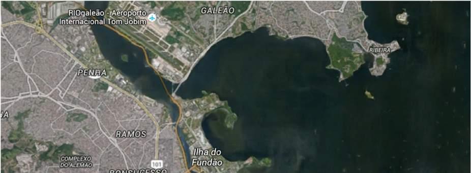
3 INTRODUCTION In Rio de Janeiro, both airports are located next to the sea. It is well known that urban areas are characterized by different microclimates and the formation of heat islands, with an increase in air temperature compared to the areas of low occupancy or rural. For the city of Rio de Janeiro, this standard provides climatic data from Antônio Carlos Jobim International and Santos Dumont Airports. Both are located next to the sea, so it can be supposed that they are less impacted by the urban heating.


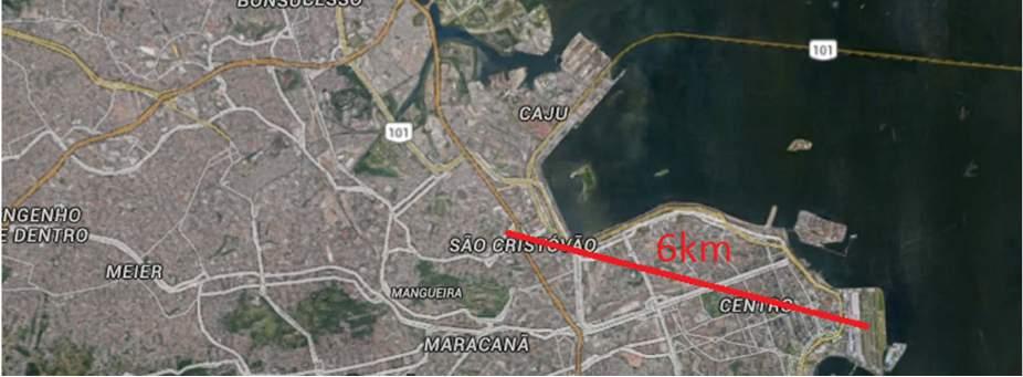
4 INTRODUCTION The Figure presents a map showing that it is far respectively, 6 km and 10 km, from the Santos Dumont and Antonio Carlos Jobim airports. For any place in the Rio de Janeiro city, there is no indication in the NBR about what climatic data must be chosen. It is well known that air conditioning designers adopt the highest temperature data.
5 INTRODUCTION
6 INTRODUCTION

7 Methodology The São Cristóvão meteorological station belongs to the Fundação Instituto de Geotécnica (Geo-Rio), within the Rio de Janeiro's City Hall, a department created for monitoring the rainfall in order to warn the population about risks of slope slips. It is located at the latitude of , the longitude of and an elevation of 25 meters, on the top of the Geo- Rio building. This station measures and records temperature, humidity, pressure, rainfall and wind speed at 15 minute intervals. It has supplied access to download data since 2002, but the period used here is from 2003 to 2015 (Alerta Rio, 2016). GEO-RIO Rua Campo de São Cristóvão, 268
. The 0.4%, 1.0% and 2.0% are exceeded, on average, 35h, 88h, 175h per year, respectively, for the record period.")
8 Methodology The dry bulb temperature, dew point (DPT) and wet bulb temperature and wind speed corresponding to different annual percentage representing the value that is exceeded on average by the percentage indicated the total number of hours per year (8760h). The 0.4%, 1.0% and 2.0% are exceeded, on average, 35h, 88h, 175h per year, respectively, for the record period. (ASHRAE, 2013).
9 Methodology Meteorological data sets used for the calculations may contain missing values. Gaps up to 6 hours were filled by linear interpolation to provide the most complete possible time series. When the data at the right time are lacking, they can be replaced by data up to 0.5 hours before or after, when available (ASHRAE, 2013). Steps have been taken to ensure that the number and distribution of data missing not introduce significant deviations in the analysis. The number of dry bulb temperature values each hour for the month, after filling by interpolation must be at least 85% of the total hours for the month and the difference between the number of temperature data observed between day and night should be less than 60 (ASHRAE, 2013). Some months were also eliminated during the additional quality control checks. The dry bulb temperature of a station will only be used for design calculation if there was data from at least eight months that met the quality control and selection criteria from the registration period for each month of the year. For example, we must have at least eight months of January, February, March, April, May, June, July, August, September, October, November and December (ASHRAE, 2013).
10 Methodology Simulation - Calculation of thermal load - HAP by Carrier - Dynamic effect of the building
11 Methodology The plant of the building used for study case is shown in Figure. The building has an area of 120m² and it is internally divided into administrative room, reception, security room, circulation area, information technology room, dining room and bathrooms. It is placed in the São Cristóvão neighborhood, and for this investigation, strategically located where there is a meteorological station.
12 Methodology Ambientes Área (m²) Pé Direito (m) NBR ANVISA (m³/h) (m³/h) Guarita ISI 9,9 3, Sala de Crachá 4,2 3, TIC 16,2 3, Briefing 7,1 3, Circulação 7,6 3, Recepção 45,4 3, Supervisor - Vigilância 12,5 3, Copa p/ vigilância 18,3 3,
13 Results The table presents DBT, CWBT and DPT at the three frequency levels for the Santos Dumont and Antônio Carlos Jobim airports reproduced from the NBR and also those generated for São Cristóvão.
14 Results Results After defined the entry temperatures, thermal load calculations were made in order to evaluate their influence on the air conditioning design. The table shows the thermal loads corresponding to the three places at the three frequency levels. Thermal Load 0.40% 1.00% 2.00% Antônio C. Jobim 40.4kW 38.6kW 37.5kW Santos Dumont 38.1kW 36.5kW 35.7kW São Cristóvão 37.9kW 36.3kW 34.7kW

15 Results Results The Antônio Carlos Jobim airport had the highest thermal load at all frequency levels. The thermal loads for São Cristóvão and Santos Dumont airport are very close at the frequency levels of 0.4% and 1.0%..
16 Conclusion As soon as the costs of automated meteorological stations have decreased, more suitable climatic data have become available. On the other hand, HVAC designer use commercial software for thermal load calculation where it is comfortable to pre-select climatic data ready available, usually that presented in the design standards. The DBTs calculated for São Cristóvão have confirmed that there is an increasing temperature gradient from the south to the north in the study region. Since São Cristóvão is a neighborhood where buildings up to 2 floors are predominant, the elevation of its meteorological station has contributed to a negligible urban heating perception. Although the DBT for São Cristóvão is midway between the others, the thermal load for São Cristóvão was the lowest. This can be justified due to its lower air humidity. The variations of the thermal loads among the sites chosen are around 6% for the studied construction, which does not significantly interfere in the selection of the air conditioning equipment. At first the size of the building should be higher for that percentage has a significant impact on thermal load calculation. This research will go on encompassing other sites within the Rio de Janeiro metropolitan region.
17 References References ASSOCIAÇÃO BRASILEIRA DE NOMAS TÉCNICAS - ABNT, NBR : Instalações de Ar Condicionado Sistemas Centrais e Unitários. Parte 1: Projeto das instalações. Rio de Janeiro, RJ, Brazil. American Society of Heating, Refrigerating, and Air-Conditioning Engineers - ASHRAE., Handbook Fundamentals. Chapter.14. Climatic Design Information. Atlanta, GA, USA. Carrier, HAP - Hourly Analysis Program, version 4.9.1, USA. Sistema de Alerta Rio da Prefeitura do Rio de Janeiro, , Rio de Janeiro, RJ, Brazil Stull, R.B., An Introduction to Boundary Layer Meteorology, Kluwer Academic Publishers, Dordrecht.
PROPOSAL OF SEVEN-DAY DESIGN WEATHER DATA FOR HVAC PEAK LOAD CALCULATION
 Ninth International IBPSA Conference Montréal, Canada August 5-8, PROPOSAL OF SEVEN-DAY DESIGN WEATHER DATA FOR HVAC PEAK LOAD CALCULATION Hisaya ISHINO Faculty of Urban Environmental Sciences, Metropolitan
Thermal Comfort Conditions for a Tropical City, Salvador Brazil
 September 2004 Page 1 of 1 Thermal Comfort Conditions for a Tropical City, Salvador Brazil Telma Andrade 1,2, Jussana Nery 1, Tereza Freire 1, Lutz Katzschner 3 and Danilo Fortuna 1 1 Federal University
Air Temperature and Urban Form Studies in Open Spaces. The Case of Campinas, Brazil
 Air Temperature and Urban Form Studies in Open Spaces. The Case of Campinas, Brazil Claudia Cotrim PEZZUTO, Lucila Chebel LABAKI, Lauro L. FRANCISCO FILHO School of Civil Engineering UNICAMP university
APPENDIX G-7 METEROLOGICAL DATA
 APPENDIX G-7 METEROLOGICAL DATA METEOROLOGICAL DATA FOR AIR AND NOISE SAMPLING DAYS AT MMR Monthly Normals and Extremes for Honolulu International Airport Table G7-1 MMR RAWS Station Hourly Data Tables
A Typical Meteorological Year for Energy Simulations in Hamilton, New Zealand
 Anderson T N, Duke M & Carson J K 26, A Typical Meteorological Year for Energy Simulations in Hamilton, New Zealand IPENZ engineering trenz 27-3 A Typical Meteorological Year for Energy Simulations in
The Numerical Psychrometric Analysis
 he Numerical sychrometric Analysis by Jorge R. López Busó, MSME, E Introduction he sychrometric Analysis is the base of any HVAC system design. Nowadays, the psychrometric analysis is mainly done by means
Urban heat island in the metropolitan area of São Paulo and the influence of warm and dry air masses during summer
 Urban heat island in the metropolitan area of São Paulo and the influence of warm and dry air masses during summer Flavia N. D. Ribeiro1, Arissa S. umezaki1, Jhonathan F. T. de Souza1, Jacyra Soares2,
Wind Resource Data Summary Cotal Area, Guam Data Summary and Transmittal for December 2011
 Wind Resource Data Summary Cotal Area, Guam Data Summary and Transmittal for December 2011 Prepared for: GHD Inc. 194 Hernan Cortez Avenue 2nd Floor, Ste. 203 Hagatna, Guam 96910 January 2012 DNV Renewables
PREDICTING OVERHEATING RISK IN HOMES
 PREDICTING OVERHEATING RISK IN HOMES Susie Diamond Inkling Anastasia Mylona CIBSE Simulation for Health and Wellbeing 27th June 2016 - CIBSE About Inkling Building Physics Consultancy Susie Diamond Claire
Meteorology. Circle the letter that corresponds to the correct answer
 Chapter 3 Worksheet 1 Meteorology Name: Circle the letter that corresponds to the correct answer 1) If the maximum temperature for a particular day is 26 C and the minimum temperature is 14 C, the daily
The Climate of Grady County
 The Climate of Grady County Grady County is part of the Central Great Plains, encompassing some of the best agricultural land in Oklahoma. Average annual precipitation ranges from about 33 inches in northern
Desertification in the Aral Sea Region: A study of the natural and Anthropogenic Impacts
 EU Inco-Copernicus Program: The Aral-Kum Project Desertification in the Aral Sea Region: A study of the natural and Anthropogenic Impacts Contract number : ICA2-CT-2000-10023 Final objective of the project
Arun Platform Tide Gauge
 Arun Platform Tide Gauge Location OS: 506423E 97778N WGS84: Latitude: 50 46 11.39042"N Longitude: 00 29 31.73595"W Instrument Valeport 730 (Druck Pressure Transducer) TGBM Benchmarks Benchmark Description
J17.3 Impact Assessment on Local Meteorology due to the Land Use Changes During Urban Development in Seoul
 J17.3 Impact Assessment on Local Meteorology due to the Land Use Changes During Urban Development in Seoul Hae-Jung Koo *, Kyu Rang Kim, Young-Jean Choi, Tae Heon Kwon, Yeon-Hee Kim, and Chee-Young Choi
Taking the garbage out of energy modeling through calibration
 Taking the garbage out of energy modeling through calibration Presented to the Madison Chapter of ASHRAE February 8, 2016 Presented by Benjamin Skelton P.E. BEMP President, Cyclone Energy Group Acknowledgments
dated : 15 June 2015 Figure 1. Geographic localization of the Metropolitan Regions of São Paulo and Rio de Janeiro Cities.
 PROGRAM MCITY BRAZIL Amauri Pereira de Oliveira 1, Edson Pereira Marques Filho 2, Mauricio Jonas Ferreira 1, Jacyra Soares 1, Georgia Codato 1, Marija Božnar 3, Primož Mlakar 3, Boštjan Grašič 3, Eduardo
INFLUENCE OF THE AVERAGING PERIOD IN AIR TEMPERATURE MEASUREMENT
 INFLUENCE OF THE AVERAGING PERIOD IN AIR TEMPERATURE MEASUREMENT Hristomir Branzov 1, Valentina Pencheva 2 1 National Institute of Meteorology and Hydrology, Sofia, Bulgaria, Hristomir.Branzov@meteo.bg
8.1 Attachment 1: Ambient Weather Conditions at Jervoise Bay, Cockburn Sound
 8.1 Attachment 1: Ambient Weather Conditions at Jervoise Bay, Cockburn Sound Cockburn Sound is 20km south of the Perth-Fremantle area and has two features that are unique along Perth s metropolitan coast
The Climate of Pontotoc County
 The Climate of Pontotoc County Pontotoc County is part of the Crosstimbers. This region is a transition region from the Central Great Plains to the more irregular terrain of southeast Oklahoma. Average
PAUL RUDOLPH Oriental Masonic Gardens
 1 PAUL RUDOLPH Oriental Masonic Gardens Latitude _ 41.3 N Longitude _ 72.9 W Climate: transition between Cfa _ Humid Subtropical and Dfa_ Humid Continental climate 2 Paul Rudolph INTRODUCTION Fig. 1 -
DEVELOPMENT OF COOLING LOAD TEMPERATURE DIFFERENTIAL VALUES FOR BUILDING ENVELOPES IN THAILAND
 DEVELOPMENT OF COOLING LOAD TEMPERATURE DIFFERENTIAL VALUES FOR BUILDING ENVELOPES IN THAILAND Somsak Chaiyapinunt*, Khemmachart Mangkornsaksit, and Boonyarit Phueakphongsuriya ABSTRACT This article describes
New Intensity-Frequency- Duration (IFD) Design Rainfalls Estimates
 Design Rainfalls Estimates") New Intensity-Frequency- Duration (IFD) Design Rainfalls Estimates Janice Green Bureau of Meteorology 17 April 2013 Current IFDs AR&R87 Current IFDs AR&R87 Current IFDs - AR&R87 Options for estimating
New Intensity-Frequency- Duration (IFD) Design Rainfalls Estimates Janice Green Bureau of Meteorology 17 April 2013 Current IFDs AR&R87 Current IFDs AR&R87 Current IFDs - AR&R87 Options for estimating
The Climate of Payne County
 The Climate of Payne County Payne County is part of the Central Great Plains in the west, encompassing some of the best agricultural land in Oklahoma. Payne County is also part of the Crosstimbers in the
Generation of an Annual Typical Meteorological Solar Radiation for Armidale NSWAustralia
 IOSR Journal of Engineering (IOSRJEN) ISSN (e): 2250-3021, ISSN (p): 2278-8719 Vol. 04, Issue 04 (April. 2014), V1 PP 41-45 www.iosrjen.org Generation of an Annual Typical Meteorological Solar Radiation
The Climate of Kiowa County
 The Climate of Kiowa County Kiowa County is part of the Central Great Plains, encompassing some of the best agricultural land in Oklahoma. Average annual precipitation ranges from about 24 inches in northwestern
ARUBA CLIMATOLOGICAL SUMMARY 2014 PRECIPITATION
 ARUBA CLIMATOLOGICAL SUMMARY 2014 PRECIPITATION The total amount of rainfall recorded at Reina Beatrix International Airport for the year 2014 was 309.2 mm. This is 34.4 % below normal ( Figure 1 ). During
Solar radiation in Onitsha: A correlation with average temperature
 Scholarly Journals of Biotechnology Vol. 1(5), pp. 101-107, December 2012 Available online at http:// www.scholarly-journals.com/sjb ISSN 2315-6171 2012 Scholarly-Journals Full Length Research Paper Solar
The Climate of Seminole County
 The Climate of Seminole County Seminole County is part of the Crosstimbers. This region is a transition region from the Central Great Plains to the more irregular terrain of southeastern Oklahoma. Average
WHEN IS IT EVER GOING TO RAIN? Table of Average Annual Rainfall and Rainfall For Selected Arizona Cities
 WHEN IS IT EVER GOING TO RAIN? Table of Average Annual Rainfall and 2001-2002 Rainfall For Selected Arizona Cities Phoenix Tucson Flagstaff Avg. 2001-2002 Avg. 2001-2002 Avg. 2001-2002 October 0.7 0.0
The Climate of Bryan County
 The Climate of Bryan County Bryan County is part of the Crosstimbers throughout most of the county. The extreme eastern portions of Bryan County are part of the Cypress Swamp and Forest. Average annual
The Climate of Marshall County
 The Climate of Marshall County Marshall County is part of the Crosstimbers. This region is a transition region from the Central Great Plains to the more irregular terrain of southeastern Oklahoma. Average
REVIEWS ON HYCOM AND MYOCEAN WITH FOCUS ON BRAZIL CURRENT SYSTEM, BETWEEN CABO FRIO AND CABO DE SÃO TOMÉ
 REVIEWS ON HYCOM AND MYOCEAN WITH FOCUS ON BRAZIL CURRENT SYSTEM, BETWEEN CABO FRIO AND CABO DE SÃO TOMÉ BOECHAT, A.C.R.¹* & DA CRUZ, L.M.M. 1 1. Prooceano Serviço Oceanográfico e Ambiental Ltda. *Corresponding
Drought in Southeast Colorado
 Drought in Southeast Colorado Nolan Doesken and Roger Pielke, Sr. Colorado Climate Center Prepared by Tara Green and Odie Bliss http://climate.atmos.colostate.edu 1 Historical Perspective on Drought Tourism
CHAPTER-11 CLIMATE AND RAINFALL
 CHAPTER-11 CLIMATE AND RAINFALL 2.1 Climate Climate in a narrow sense is usually defined as the "average weather", or more rigorously, as the statistical description in terms of the mean and variability
Range Cattle Research and Education Center January CLIMATOLOGICAL REPORT 2016 Range Cattle Research and Education Center.
 1 Range Cattle Research and Education Center January 2017 Research Report RC-2017-1 CLIMATOLOGICAL REPORT 2016 Range Cattle Research and Education Center Brent Sellers Weather conditions strongly influence
Analysis of Typical Meteorological Year for Seeb/Muscat, Oman
 Analysis of Typical Meteorological Year for Seeb/Muscat, Oman Y. H. Zurigat 1, N. M. Sawaqed 2, H. Al-Hinai 3 and B. A. Jubran 4 1 Department of Mechanical Engineering, University of Jordan, Amman-Jordan
Intraseasonal Characteristics of Rainfall for Eastern Africa Community (EAC) Hotspots: Onset and Cessation dates. In support of;
 Hotspots: Onset and Cessation dates. In support of;") Intraseasonal Characteristics of Rainfall for Eastern Africa Community (EAC) Hotspots: Onset and Cessation dates In support of; Planning for Resilience in East Africa through Policy, Adaptation, Research
Intraseasonal Characteristics of Rainfall for Eastern Africa Community (EAC) Hotspots: Onset and Cessation dates In support of; Planning for Resilience in East Africa through Policy, Adaptation, Research
Chapter 3. Materials and Methods
 Chapter 3 Materials and Methods CHAPTER3 MATERIALS AND METHODS The present study aims to identify the role of climatic factors in the dispersal of air pollutants released into the atmosphere at some important
Drought Monitoring in Mainland Portugal
 Drought Monitoring in Mainland Portugal 1. Accumulated precipitation since 1st October 2014 (Hydrological Year) The accumulated precipitation amount since 1 October 2014 until the end of April 2015 (Figure
Technical Memorandum. City of Salem, Stormwater Management Design Standards. Project No:
 Technical Memorandum 6500 SW Macadam Avenue, Suite 200 Portland, Oregon, 97239 Tel: 503-244-7005 Fax: 503-244-9095 Prepared for: Project Title: City of Salem, Oregon City of Salem, Stormwater Management
The Effect of Cloudy Days on the Annual Typical Meteorological Solar Radiation for Armidale NSW, Australia
 IOSR Journal of Engineering (IOSRJEN) ISSN (e): 2250-3021, ISSN (p): 2278-8719 Vol. 04, Issue 08 (August. 2014), VX PP 14-20 www.iosrjen.org The Effect of Cloudy Days on the Annual Typical Meteorological
Research Note COMPUTER PROGRAM FOR ESTIMATING CROP EVAPOTRANSPIRATION IN PUERTO RICO 1,2. J. Agric. Univ. P.R. 89(1-2): (2005)
: (2005)") Research Note COMPUTER PROGRAM FOR ESTIMATING CROP EVAPOTRANSPIRATION IN PUERTO RICO 1,2 Eric W. Harmsen 3 and Antonio L. González-Pérez 4 J. Agric. Univ. P.R. 89(1-2):107-113 (2005) Estimates of crop
Research Note COMPUTER PROGRAM FOR ESTIMATING CROP EVAPOTRANSPIRATION IN PUERTO RICO 1,2 Eric W. Harmsen 3 and Antonio L. González-Pérez 4 J. Agric. Univ. P.R. 89(1-2):107-113 (2005) Estimates of crop
Rainfall is the major source of water for
 RESEARCH PAPER: Assessment of occurrence and frequency of drought using rainfall data in Coimbatore, India M. MANIKANDAN AND D.TAMILMANI Asian Journal of Environmental Science December, 2011 Vol. 6 Issue
The Climate of Haskell County
 The Climate of Haskell County Haskell County is part of the Hardwood Forest. The Hardwood Forest is characterized by its irregular landscape and the largest lake in Oklahoma, Lake Eufaula. Average annual
POSSIBLE EFFICIENCY IMPROVEMENT BY APPLICATION OF VARIOUS OPERATING REGIMES FOR THE COOLING WATER PUMP STATION AT THERMAL POWER PLANT BITOLA
 Mijakoski, V., et al.: Possible Efficiency Improement by Application of Various Operating THERMAL SCIENCE, Year 01, Vol. 16, No. 1, pp. 63-70 63 POSSIBLE EFFICIENCY IMPROVEMENT BY APPLICATION OF VARIOUS
The Climate of Murray County
 The Climate of Murray County Murray County is part of the Crosstimbers. This region is a transition between prairies and the mountains of southeastern Oklahoma. Average annual precipitation ranges from
Best Fit Probability Distributions for Monthly Radiosonde Weather Data
 Best Fit Probability Distributions for Monthly Radiosonde Weather Data Athulya P. S 1 and K. C James 2 1 M.Tech III Semester, 2 Professor Department of statistics Cochin University of Science and Technology
Changing Hydrology under a Changing Climate for a Coastal Plain Watershed
 Changing Hydrology under a Changing Climate for a Coastal Plain Watershed David Bosch USDA-ARS, Tifton, GA Jeff Arnold ARS Temple, TX and Peter Allen Baylor University, TX SEWRU Objectives 1. Project changes
Application and verification of the ECMWF products Report 2007
 Application and verification of the ECMWF products Report 2007 National Meteorological Administration Romania 1. Summary of major highlights The medium range forecast activity within the National Meteorological
The Climate of Texas County
 The Climate of Texas County Texas County is part of the Western High Plains in the north and west and the Southwestern Tablelands in the east. The Western High Plains are characterized by abundant cropland
Geostatistical Analysis of Rainfall Temperature and Evaporation Data of Owerri for Ten Years
 Atmospheric and Climate Sciences, 2012, 2, 196-205 http://dx.doi.org/10.4236/acs.2012.22020 Published Online April 2012 (http://www.scirp.org/journal/acs) Geostatistical Analysis of Rainfall Temperature
South & South East Asian Region:
 Issued: 15 th December 2017 Valid Period: January June 2018 South & South East Asian Region: Indonesia Tobacco Regions 1 A] Current conditions: 1] El Niño-Southern Oscillation (ENSO) ENSO Alert System
Local Ctimatotogical Data Summary White Hall, Illinois
 SWS Miscellaneous Publication 98-5 STATE OF ILLINOIS DEPARTMENT OF ENERGY AND NATURAL RESOURCES Local Ctimatotogical Data Summary White Hall, Illinois 1901-1990 by Audrey A. Bryan and Wayne Armstrong Illinois
SOFTWARE FOR WEATHER DATABASES MANAGEMENT AND CONSTRUCTION OF REFERENCE YEARS
 SOFTWARE FOR WEATHER DATABASES MANAGEMENT AND CONSTRUCTION OF REFERENCE YEARS Marco Beccali 1, Ilaria Bertini 2, Giuseppina Ciulla 1, Biagio Di Pietra 2, and Valerio Lo Brano 1 1 Department of Energy,
PRELIMINARY DRAFT FOR DISCUSSION PURPOSES
 Memorandum To: David Thompson From: John Haapala CC: Dan McDonald Bob Montgomery Date: February 24, 2003 File #: 1003551 Re: Lake Wenatchee Historic Water Levels, Operation Model, and Flood Operation This
ARUBA CLIMATOLOGICAL SUMMARY 2017 PRECIPITATION
 ARUBA CLIMATOLOGICAL SUMMARY 2017 PRECIPITATION The total amount of rainfall recorded at Reina Beatrix International Airport for the year 2017 was 391.0 mm. This is 17.1 % below normal ( Figure 1 ). During
Analysis of meteorological measurements made over three rainy seasons in Sinazongwe District, Zambia.
 Analysis of meteorological measurements made over three rainy seasons in Sinazongwe District, Zambia. 1 Hiromitsu Kanno, 2 Hiroyuki Shimono, 3 Takeshi Sakurai, and 4 Taro Yamauchi 1 National Agricultural
WARM-HUMID CLIMATE: METHODOLOGY TO STUDY AIR TEMPERATURE DISTRIBUTION: MOBILE PHONES BASE STATIONS AS VIABLE ALTERNATIVE FOR FIXED POINTS
 WARM-HUMID CLIMATE: METHODOLOGY TO STUDY AIR TEMPERATURE DISTRIBUTION: MOBILE PHONES BASE STATIONS AS VIABLE ALTERNATIVE FOR FIXED POINTS Angelina Dias Leão Costa (1); Lucila Labaki (2); Virgínia Araújo
ESTIMATION OF AUTOMOBILE COOLING LOADS FOR AIR CONDITIONING SYSTEM DESIGN
 Nigerian Research Journal of Engineering and Environmental Sciences 596 Original Research Article ESTIMATION OF AUTOMOBILE COOLING LOADS FOR AIR CONDITIONING SYSTEM DESIGN *Omo-Oghogho, E., Aliu, S.A.,
MESOSCALE MODELLING OVER AREAS CONTAINING HEAT ISLANDS. Marke Hongisto Finnish Meteorological Institute, P.O.Box 503, Helsinki
 MESOSCALE MODELLING OVER AREAS CONTAINING HEAT ISLANDS Marke Hongisto Finnish Meteorological Institute, P.O.Box 503, 00101 Helsinki INTRODUCTION Urban heat islands have been suspected as being partially
Institut national des sciences appliquées de Strasbourg GENIE CLIMATIQUE ET ENERGETIQUE APPENDICES
 Institut national des sciences appliquées de Strasbourg GENIE CLIMATIQUE ET ENERGETIQUE APPENDICES DEVELOPMENT OF A TOOL, BASED ON THE THERMAL DYNAMIC SIMULATION SOFTWARE TRNSYS, WHICH RUNS PARAMETRIC
Estimation of Diffuse Solar Radiation for Yola, Adamawa State, North- Eastern, Nigeria
 International Research Journal of Engineering and Technology (IRJET) e-issn: - Volume: Issue: Nov- www.irjet.net p-issn: - Estimation of Diffuse Solar Radiation for Yola, Adamawa State, North- Eastern,
active and discontinued climate stations in Labrador are listed in Appendix A along with
 25 4. CLIMATE 4.1 Database The climatological data for this study was provided by Environment Canada. All active and discontinued climate stations in Labrador are listed in Appendix A along with their
Geoestatistics and Kriging Techiniques for Welfare Analysis of Chickens through Enthalpy Distribution in State of São Paulo, Brazil
 Geoestatistics and Kriging Techiniques for Welfare Analysis of Chickens through Enthalpy Distribution in State of São Paulo, Brazil V. C. Rodrigues, F. M. C. Vieira, G. Borges, I. J. O. Silva, and K. O.
South & South East Asian Region:
 Issued: 10 th November 2017 Valid Period: December 2017 May 2018 South & South East Asian Region: Indonesia Tobacco Regions 1 A] Current conditions: 1] El Niño-Southern Oscillation (ENSO) ENSO Alert System
AERMOD Sensitivity to AERSURFACE Moisture Conditions and Temporal Resolution. Paper No Prepared By:
 AERMOD Sensitivity to AERSURFACE Moisture Conditions and Temporal Resolution Paper No. 33252 Prepared By: Anthony J Schroeder, CCM Managing Consultant TRINITY CONSULTANTS 7330 Woodland Drive Suite 225
C) the seasonal changes in constellations viewed in the night sky D) The duration of insolation will increase and the temperature will increase.
 the seasonal changes in constellations viewed in the night sky D) The duration of insolation will increase and the temperature will increase.") 1. Which event is a direct result of Earth's revolution? A) the apparent deflection of winds B) the changing of the Moon phases C) the seasonal changes in constellations viewed in the night sky D) the
1. Which event is a direct result of Earth's revolution? A) the apparent deflection of winds B) the changing of the Moon phases C) the seasonal changes in constellations viewed in the night sky D) the
Ryan P. Shadbolt * Central Michigan University, Mt. Pleasant, Michigan
 14A.1 RECENT CLIMATE CHANGE IN THE HIGH ELEVATIONS OF THE SOUTHERN APPALACHIANS Ryan P. Shadbolt * Central Michigan University, Mt. Pleasant, Michigan 1. INTRODUCTION Island species are often vulnerable
Urban heat island effects over Torino
 3 Working Group on Physical Aspects: Soil and Surface 3 Urban heat island effects over Torino M. Milelli 1 1 ARPA Piemonte 1 Introduction Figure 1: Urban heat island generalized scheme (source: EPA). The
WIND DATA REPORT FOR THE YAKUTAT JULY 2004 APRIL 2005
 WIND DATA REPORT FOR THE YAKUTAT JULY 2004 APRIL 2005 Prepared on July 12, 2005 For Bob Lynette 212 Jamestown Beach Lane Sequim WA 98382 By John Wade Wind Consultant LLC 2575 NE 32 nd Ave Portland OR 97212
Temporal and Spatial Distribution of Tourism Climate Comfort in Isfahan Province
 2011 2nd International Conference on Business, Economics and Tourism Management IPEDR vol.24 (2011) (2011) IACSIT Press, Singapore Temporal and Spatial Distribution of Tourism Climate Comfort in Isfahan
Weather to Climate Investigation: Maximum Temperature
 Name: Date: Guiding Questions: Weather to Climate Investigation: Maximum Temperature What are the historical and current weather patterns or events for a location in the United States? What are the long-term
TA3 Dosimetry and Instrumentation EVALUATION OF UNCERTAINTIES IN THE CALIBRATION OF RADIATION SURVEY METER POTIENS, MPA 1, SANTOS, GP 1
 TA3 Dosimetry and Instrumentation EVALUATION OF UNCERTAINTIES IN THE CALIBRATION OF RADIATION SURVEY METER POTIENS, MPA 1, SANTOS, GP 1 (1) Instituto de Pesquisas Energéticas e Nucelares ABSTRACT In order
Typical Hydrologic Period Report (Final)
") (DELCORA) (Final) November 2015 (Updated April 2016) CSO Long-Term Control Plant Update REVISION CONTROL REV. NO. DATE ISSUED PREPARED BY DESCRIPTION OF CHANGES 1 4/26/16 Greeley and Hansen Pg. 1-3,
(DELCORA) (Final) November 2015 (Updated April 2016) CSO Long-Term Control Plant Update REVISION CONTROL REV. NO. DATE ISSUED PREPARED BY DESCRIPTION OF CHANGES 1 4/26/16 Greeley and Hansen Pg. 1-3,
Scarborough Tide Gauge
 Tide Gauge Location OS: 504898E 488622N WGS84: Latitude: 54 16' 56.990"N Longitude: 00 23' 25.0279"W Instrument Valeport 740 (Druck Pressure Transducer) Benchmarks Benchmark Description TGBM = 4.18m above
Regression Models for Forecasting Fog and Poor Visibility at Donmuang Airport in Winter
 Regression Models for Forecasting Fog and Poor Visibility at Donmuang Airport in Winter S. Ruangjun 1,* and R. H. B. Exell 2 1 Weather Division (Beside Military Airport, Wing 6), Paholyothin Road, Donmuang,
Measurement of global solar radiation in Terengganu state, Malaysia
 Environmental Science and Technology Conference (ESTEC29) Kuala Terengganu Malaysia, December 7-8, 29 Measurement of global solar radiation in Terengganu state, Malaysia A.M. Muzathik 1*, W.B. Wan Nik
FRAPPÉ/DISCOVER-AQ (July/August 2014) in perspective of multi-year ozone analysis
 in perspective of multi-year ozone analysis") FRAPPÉ/DISCOVER-AQ (July/August 2014) in perspective of multi-year ozone analysis Project Report #2: Monitoring network assessment for the City of Fort Collins Prepared by: Lisa Kaser kaser@ucar.edu ph:
FRAPPÉ/DISCOVER-AQ (July/August 2014) in perspective of multi-year ozone analysis Project Report #2: Monitoring network assessment for the City of Fort Collins Prepared by: Lisa Kaser kaser@ucar.edu ph:
JOURNAL OF INTERNATIONAL ACADEMIC RESEARCH FOR MULTIDISCIPLINARY Impact Factor 1.393, ISSN: , Volume 2, Issue 4, May 2014
 Impact Factor 1.393, ISSN: 3583, Volume, Issue 4, May 14 A STUDY OF INVERSIONS AND ISOTHERMALS OF AIR POLLUTION DISPERSION DR.V.LAKSHMANARAO DR. K. SAI LAKSHMI P. SATISH Assistant Professor(c), Dept. of
Lab Activity: Climate Variables
 Name: Date: Period: Water and Climate The Physical Setting: Earth Science Lab Activity: Climate Variables INTRODUCTION:! The state of the atmosphere continually changes over time in response to the uneven
Nusipepa Lepale Samoa
 Data Collection and modelling for adaptation Nusipepa Lepale Samoa Presentation Outline Background info Geography Climate of Samoa Impacts of Climate Change (CC) in Samoa CC Adaptation in Samoa Data Observation
Chiang Rai Province CC Threat overview AAS1109 Mekong ARCC
 Chiang Rai Province CC Threat overview AAS1109 Mekong ARCC This threat overview relies on projections of future climate change in the Mekong Basin for the period 2045-2069 compared to a baseline of 1980-2005.
SEASONAL AND ANNUAL TRENDS OF AUSTRALIAN MINIMUM/MAXIMUM DAILY TEMPERATURES DURING
 SEASONAL AND ANNUAL TRENDS OF AUSTRALIAN MINIMUM/MAXIMUM DAILY TEMPERATURES DURING 1856-2014 W. A. van Wijngaarden* and A. Mouraviev Physics Department, York University, Toronto, Ontario, Canada 1. INTRODUCTION
Effects of screens set characteristics on the flow field in a wind tunnel.
 Effects of screens set characteristics on the flow field in a wind tunnel. A M Santos, D B Souza, F O Costa, M H Farias, S Araújo, Y B Zanirath National Institute of Metrology, Quality and Technology Inmetro
17th International Conference on Harmonisation within Atmospheric Dispersion Modelling for Regulatory Purposes 9-12 May 2016, Budapest, Hungary
 17th International Conference on Harmonisation within Atmospheric Dispersion Modelling for Regulatory Purposes 9-12 May 2016, Budapest, Hungary SIMULATIONS OF TRAFFIC RELATED POLLUTANTS IN A MAIN STREET
TABLE -I RAINFALL RECORDED AT PORT BLAIR (MM) FROM 1949 TO 2009
 FROM 1949 TO 2009") A. RAINFALL TABLE -I RAINFALL RECORDED AT PORT BLAIR (MM) FROM 1949 TO 2009 MONTH/YEAR 1949 1950 1951 1952 1953 1954 1955 1956 1957 1958 JANUARY 0.0 0.8 82.5 0.0 26.9 37.3 71.4 46.2 10.2 28.7 FEBRUARY
A. RAINFALL TABLE -I RAINFALL RECORDED AT PORT BLAIR (MM) FROM 1949 TO 2009 MONTH/YEAR 1949 1950 1951 1952 1953 1954 1955 1956 1957 1958 JANUARY 0.0 0.8 82.5 0.0 26.9 37.3 71.4 46.2 10.2 28.7 FEBRUARY
Jackson County 2013 Weather Data
 Jackson County 2013 Weather Data 61 Years of Weather Data Recorded at the UF/IFAS Marianna North Florida Research and Education Center Doug Mayo Jackson County Extension Director 1952-2008 Rainfall Data
Multivariate Regression Model Results
 Updated: August, 0 Page of Multivariate Regression Model Results 4 5 6 7 8 This exhibit provides the results of the load model forecast discussed in Schedule. Included is the forecast of short term system
SWIM and Horizon 2020 Support Mechanism
 SWIM and Horizon 2020 Support Mechanism Working for a Sustainable Mediterranean, Caring for our Future REG-7: Training Session #1: Drought Hazard Monitoring Example from real data from the Republic of
DETERMINING THE RAINFALL INDICES EXPECTED IN A RETURN PERIOD FOR THE REGION OF GUARATINGUETÁ SP - BRAZIL
 DETERMINING THE RAINFALL INDICES EXPECTED IN A RETURN PERIOD FOR THE REGION OF GUARATINGUETÁ SP - BRAZIL LIMA E SILVA, João Ubiratan¹ ERBERELLI, Nathália Pivatto² 1 Phd Professor in Geo-sciences and Environment
Discoverer Automated Weather System Data Quality Control Report
 Discoverer Automated Weather System Data Quality Control Report Kennard B. Kasper and Shawn R. Smith World Ocean Circulation Experiment (WOCE) Surface Meteorological Data Assembly Center Center for Ocean
VIRGINIA S I-77 VARIABLE SPEED LIMIT SYSTEM FOR LOW VISIBILITY CONDITIONS
 VIRGINIA S I-77 VARIABLE SPEED LIMIT SYSTEM FOR LOW VISIBILITY CONDITIONS Christopher D. McDonald, PE, PTOE Regional Operations Director, Southwest Region NRITS and ITS Arizona Annual Conference October
The micro-climate of a mixed urban parkland environment
 The micro-climate of a mixed urban parkland environment Centre For Water Sensitive Cities, Cities as Water Supply Catchments School of Geography and Environmental Science, Monash University 22 February
Analysis of Relative Humidity in Iraq for the Period
 International Journal of Scientific and Research Publications, Volume 5, Issue 5, May 2015 1 Analysis of Relative Humidity in Iraq for the Period 1951-2010 Abdulwahab H. Alobaidi Department of Electronics,
General Circulation of Basic Atmospheric Parameters over a Low Latitude Station (Hyderabad)
") IOSR Journal of Applied Physics (IOSR-JAP) e-issn: 2278-4861.Volume 7, Issue 3 Ver. III (May. - Jun. 2015), PP 01-05 www.iosrjournals.org General Circulation of Basic Atmospheric Parameters over a Low
IOSR Journal of Applied Physics (IOSR-JAP) e-issn: 2278-4861.Volume 7, Issue 3 Ver. III (May. - Jun. 2015), PP 01-05 www.iosrjournals.org General Circulation of Basic Atmospheric Parameters over a Low
Chapter 3: Temperature
 Chapter 3: Temperature Elements of WAC (Basic Measurable Properties) 1. Temperature of Air 2. Humidity of Air 3. Cloud Cover (type and amount) 4. Precipitation (type and amount) 5. Air Pressure 6. Wind
Canada only has 7 of these biomes. Which biome do you think does not exist in Canada and why?
 Climate Zones and Biomes There are 8 defined biomes Permanent ice Tundra Boreal Forest Temperate deciduous forest Temperate rainforest Grassland Desert Tropical rainforest What is a biome? a major biotic
Becky Bolinger Water Availability Task Force November 13, 2018
 Colorado Climate Center WATF Climate Update Becky Bolinger Water Availability Task Force November 13, 2018 COLORADO CLIMATE CENTER Water Year 2018 Colorado s Climate in Review COLORADO CLIMATE CENTER
Meteorology. Chapter 15 Worksheet 1
 Chapter 15 Worksheet 1 Meteorology Name: Circle the letter that corresponds to the correct answer 1) The Tropic of Cancer and the Arctic Circle are examples of locations determined by: a) measuring systems.
Plan for operational nowcasting system implementation in Pulkovo airport (St. Petersburg, Russia)
") Plan for operational nowcasting system implementation in Pulkovo airport (St. Petersburg, Russia) Pulkovo airport (St. Petersburg, Russia) is one of the biggest airports in the Russian Federation (150
Plan for operational nowcasting system implementation in Pulkovo airport (St. Petersburg, Russia) Pulkovo airport (St. Petersburg, Russia) is one of the biggest airports in the Russian Federation (150