CALmRA TING THE QUIKSCA T/SEAWIN DS RADAR FOR
|
|
|
- Rosalyn Russell
- 6 years ago
- Views:
Transcription
1 CALmRA TING THE QUIKSCA T/SEAWIN DS RADAR FOR MEAS URIN G RAINRA TE OVER THE OCEANS David E. Weissman Dept. of Engineering. Hofstra University, Hempstead, New York Tel:(516) ; Fax: (516) eggdew@hofstra.edu Mark A. Bourassa COAPSfThe Florida State University, Tallahassee, FL Jeffrey Tongue National Weather Service, Upton, New York Abstract This effort continues a study of the effects of rain, over the oceans, on the signal retrieved by the. SeaWinds scatterometer. It is determined that the backscatteradar cross section can be used to estimate the volumetric rain rate, averaged horizontally, across the surface resolution cells of the scatterometer. The dual polarization of the radar has a key role in developing this capability. The relative magnitudes of the radar backscatter depends on the volumetric rainrate, the rain column height and surface wind velocity, the viewing angle, as well as the polarization (due to the oblateness of raindrops at the higher rainrates). The approach to calibrating the SeaWinds normalized radar cross section (NRCS) is to collect NWS NEXRAD radar-derived rainrate measurements (4 km spatial resolution and 6 minute rotating cycles) co-located in space (offshore) and time with scatterometer observations. These calibration functions lead to a Z-R relationship, which is then used at mid-ocean locations to estimate the rainrate in 0.25 or larger resolution cells, which are compared with TRMM TMI rain estimates. Experimental results to date are in general agreement with simplified theoretical models of backscatter from rain, for this frequency, 14 GHz. These comparisons show very good agreement on a cell-by-cell basis with the TMI estimates for both wide areas (1000 KM) and smaller area rain events. Manuscript submitted for publication to IEEE Transactions on Geoscience and Remote Sensing September 2002

2 I. INTRODUCTION Rain interferes with the intended application of the measurements of the sea surface's radar cross section by the Sea Winds scatterometer: the estimation of the sea surface wind speed and direction [1],[2]. The presence of rain regions within the boundaries of the illuminated surface area results in additional backscatter from these atmospheric volumes, and possibly attenuation of the beam directed towards the surface and the backscatter from the surface. In many cases, depending on the wind magnitude, the backscatter from the rain will augment or dominate the received signal and the measured NRCS. This results in overestimates of the wind magnitude, and meaningless wind direction values [3]. The relatively long duration transmitted pulse provides the equivalent of a continuous-wave radar. The backscatter from the rain volume is the path-integrated value that may include the complete column of rain, or possibly a thinner layer when the beam attenuation is large enough to suppress most of the power density before it reaches the sea surface. Steps were taken to quantify the effect of rain on SeaWinds NRCS, using NEXRAD Level m rain data for in-situ measurements, over the ocean and sufficiently far offshore to avoid land contamination issues. The near simultaneous NEXRAD composite reflectivity data ("Z" values; e.g., Figure I), were converted to rainrate in 4 kin cells, then they were combined into an average over an approximate scatterometer footprint (a 28 kin square), centered at each scatterometer cell. Each of the co-located SeaWinds NRCS's, subset by polarization, are assigned to that average rainrate. The wide variation of the rain intensity within the area spanned by the scatterometer swath results in a sizeable dynamic range of NRCS values. These data provide the basis of calibration curves for each polarization; these curves are referred to as Z-R functions in radar meteorology terminology. These functions are used over the open ocean to convert the QSCA T L2A NRCS data into rainrate estimates, The rain estimates can then be compared with values derived from the passive microwave imager (TMI) onboard the TRMM satellite. Numerous events in disparate ocean regions were analyzed and all produced consistently good agreement between the TMI and this SeaWinds-algorithm rainrate for averages over a 0.50 square latitude/longitude region.
3
4 capabilities. One recent innovation gaining increased application is coherent dual-polarization backscatter measurements to discriminate between the smaller spherical raindrops and the larger oblate drops, the distributions of which are functions of rainrate. The difference of H-pol and V -pol signals due to this effect is called "differential-reflectivity"[6]. While Sea Winds is limited to incoherent dualpolarization, it still has the capability to exploit this phenomenon. This differential polarization response of the Sea Winds scatterometer to moderate and large rainrates can be exploited for quantitative precipitation detection and measurement on many different time and spatial scales. This technique has been applied across a wide of frequencies from 3 to 35 Ghz [7]. Of particular relevance to SeaWinds, is that Holt [7] shows that the key measurable parameter, the differential reflectivity (ZoR)' has a very similar dependence on dropsize and rainrate at 16 GHz (Ku-band) as it does at 3 GHz (S-Band) which is the nominal National Weather Service NEXRAD radars' frequency. m.approach The virtually instantaneous co-location of NEXRAD rain measurements with QuikSCA T and buoy observations is an advance in the quantitative detennination of the effect of rainfall on QuikSCA T NRCS data. The NEXRAD data products consist of radar scans taken only 6 minutes apart, so that the time coincidences with QSCA T observations are sufficiently close to be viewed as effectively instantaneous. Considering how rapidly rain cell spatial structures evolve and how rain intensity varies with time, this close a time difference is essential in order to have a valid observation of the precipitation conditions affecting the QSCA T measurement. The 4 km resolution of NEXRAD is valuable for resolving the spatial variability. A NEXRAD Level ill "Composite Reflectivity" data product with 4 kin spatial resolution, is shown in Figure (1). This depicts a maximum S-band reflectivity found on any constant elevation angle azimuthal sweep of a volume scan projected onto each Cartesian grid box [8]. The rainrate is displayed as a quantized color scale for the Reflectivity Factor, Z, in 5 dbz steps. This example is from the Wilmington, NC station on Sept. 9, Buoy #41004 is indicated with a star symbol. The concentric circles are centered at the NEXRAD site (Lat. and Lon specified in figure), and represent 4


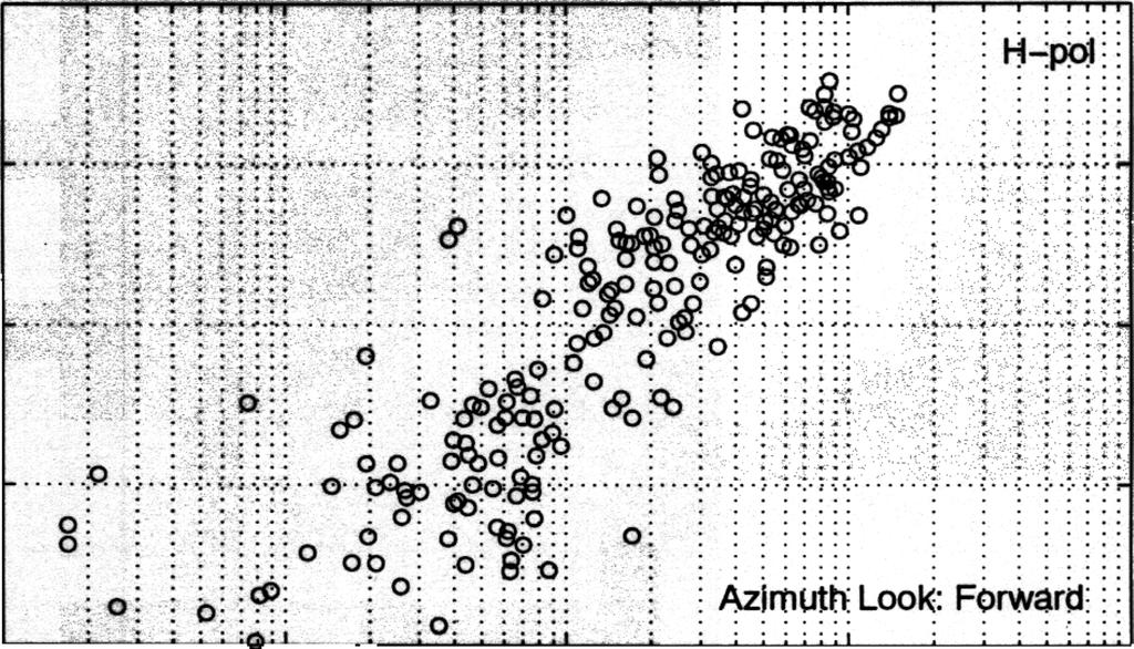
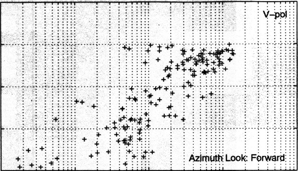
5 range steps of 115 kin. The latitude and longitude grid lines are 1 degree each. Since the QuikSCAT resolution for a radar cross section cell is approximated to be a 28 krn square, appreciable averaging of the NEXRAD 4 kin resolution elements was necessary to create an equivalent spatial rain estimate After converting the NEXRAD RCS from "dbz" into rainrate and then averaging each 7 -by- 7 array (equivalent to a 28 kin square area) a new data array of rainrate, centered at each QSCA T cell location, and compatible with the spatial resolution of satellite radar was produced. The buoy wind measurement. southeast of the rain area (location indicated by a star), was about 3 m/s for a two hour period centered at the time of the QSCA T overpass. Another buoy (# 41002) on the eastern side of this rain area (Lat. = 32.3, Long.=75.48) measured winds of about 5.5 m/s for a two-hour interval around the overpass time. The locations of the QuikSCA T NRCS points used in this study were constrained to be no farther than 250 kin from the NEXRAD station, over the ocean. Specifically, they lie between 32 and 34.5 latitude and to -76 longitude. The reason is that the accuracy of near surface rain estimates decreases with distance from the NEXRAD. The NRCS data points were identified as either Horizontal or Vertical polarization and separated accordingly. This was straightforward since they have different incidence angles, 46 and 54 respectively. Another separation was made which selected NRCS points which were observed by the forward beam sweep of the satellite antenna. This effectively constrains all the data points to be within a narrow range of radar azimuth angles, when the area under study is much less than the 1400 kin swath width. Each data point represents the average NRCS ( 0) from an elliptically shaped cell 25-by-35 km. The center point of this cell is used as the center of a 28 km square area over which the mean rainrate is computed using the 4 km NEXRAD cells (from data shown in Fig. 1) formed into 7-by-7 arrays. Figure 2 shows the separate plots of V-pol andh-pol o's (converted to decibels) versus the mean rainrates for each corresponding cell. Obviously, those NRCS cells which fall in an area without rainfall will not be plotted. The two data sets span a wide dynamic range; approximately 2 orders of magnitude. Even though these plots display considerable scatter for both quantities, there is a clear IJ:1onotonic relationship betwn NRCS and rainrate. There is a fundamental distinction that contributes to the data scatter. The scatterometer operates effectively in a CW mode and integrates the rain backscatter throughout the full column in the line-of-sight. The size of the NRCS will depend on the height of the rain column and the rain profile within. The NEXRAD data product, measured in mm/hr, is more like a flux quantity representing a

6 flow rate at a specific reference height. In this case, it is the maximum value in a vertical column. Therefore variations in the length of the rain column will affect the NRCS but may not affect the NEXRAD product by the same amount. Another quantity that will cause scatter in the NRCS data is the variability of the drop size distribution. These uncertainties, while undesirable, does not appear to negate the usefulness of the relationship seen in this figure. The lower graph of the H-pol data has been fit with a regression function to create a "Z-R" function for the Ku-band scatterometer. This function is similar to the one developed using a simple theoretical model for spherical raindrops [Weissman, et al, 2001]. This empirical function can then be used to estimate rainrates over the ocean, with cell sizes determined by the scatterometeresolution, once it has been determined that the scatterometer is receiving backscatter from rain volume. The prerequisite to applying this procedure is having a reliable "rain-flag., At the wind speed regime which is believed to exist at the surface, if no rain were present, the NRCS data points for both polarizations would be in the range from -30 db to -25 db. For rainrates larger than 0.5 mrn/hr the NRCS is found to equal or exceed these surface estimates, and both polarization oo's clearly increase proportionally to the rainrate. A more careful comparison of the data for rainrates larger than or equal to 1 mm/hr in Figure 3 shows that H-pol NRCS tends to exceed the V -pol. This effect, the differential reflectivity (R) is well known in the field of radar meteorology. The physical basis for this is the oblateness of raindrops, once they become larger than about 2 mm is diameter [9]. Fortunately, the normal no-rain relationship between the two polarizations is that V-pol exceeds H-pol by a few decibels or more, depending on the surface wind speed. Therefore, when an average surface area ( say 0.25 Lat/Lon square) displays a higher NRCS for H-pol than V-pol, it is very likely that appreciable rain is present. This effect has been adopted as a "rain-flag". It is then used in conjunction with the Z-R formula derived from the H-pol data of Figure 2 to estimate rainrates in the open ocean. Note that while the swath of SeaWinds is 1600 km, the H-pol observations only cover a 1400 kin swath. IV. RESULTS Several co-locations of the TRMM satellite and QuikSCA T were studied to detennine the level of agreement between rain estimates produced by the passive microwave imager, TMI, and the method
7 discussed above. The TRMM product used here, which has a 760 krn wide swath, contains daily files with 24 hourly segments of the orbit. The gridded rainrate estimates are in 0.50 cells in units of mm/hr, and are accompanied by the time of observation. The procedure used here is to survey the rain observations collected by TRMM and then seek a sufficiently close encounter (in space and time) with QSCA T. Numerous events have been studied with similar results. A good example is an event of July 20,2001 in an ocean region west of Nicaragua. A section of the hourly segment corresponding to 12:05Z is extracted from the TRMM data image (Figure 4). The features here are typical of many other observations. Relative small clusters of high rainrates, often exceeding 7 rnrn/hr, occur in areas of 1-to-2 degrees latitude and longitude. These are imbedded in much larger regions of lower rainrates. A QuikSCAT orbit co-location was observed at 12:00Z, but with an oblique swath that covered only the region east of -990 longitude, and slanted to exclude some of the section below 8.50 latitude. The higher resolution of the QSCA T L2A data (the highest level data set containing backscatter observations) are used to estimate mean rainrates in cells, using the Z-R relation discussed above. The rain rates are averaged again to create a matching 0.50 cell rainrate. Therefore, a sub-region of the rain seen by TMI (Figure 4) is plotted in Figure 5 (upper graph) for comparison with the new SeaWinds rain estimates in an identical region in the lower graph. The scatterometer rainrates (lower graph) are seen to provide a very similar spatial image of the rain occurrence and intensity. Some limitations are that the scatterometer may not detect some of the lower rainrates detected by TRMM, but this appears to be minor shortcoming. A point-by-point scatterplot of the TRMM versus QSCAT rainrates (Figure 6) shows those data points where neither has a zero value. The solid line indicates perfect agreement and the dashed lines show the limits for differences that are less than a factor of two. Clearly, most of the comparison points show that the QSCA T rain estimates are within a factor of two of the TRMM values. A simple summation of all TRMM and QSCA T rainrates over the entire region under study produces very close agreement (within 20%). This consistency will be useful if the two data sets are combined for monitoring precipitation over the global oceans. The general agreement between cell rainrates is better for those rainrates above I mm/hr. Possible reasons for disagreements at the lower rainrates are errors in either instrument at lower rainrates, variations in the height and uniformity of the rain column, and variations in the drop size distribution.
.")
, in the future.")
8 V. SUMMARY This study provides evidence on the capability of Sea Winds scatterometer to estimate rainrates over the ocean. The relationships derived from empirical data are consistent with those used in radar meteorology, and applied to weather radar and the Tropical Rainfall Measurement Mission (TRMM). The principal algorithm was derived from collocated NEXRAD and QSCAT measurements. It also exploits the differential reflectivity associated with moderate and higher rainrates. Analysis is continuing to refine the features and quality of the algorithms for rain-flagging, and rainrate estimation (Z-R formula), in the future. Attention will also be directed at situations with strong wind, and storm conditions to test the usefulness and range of validity of this technique. Considering the wide swath of the scatterometer and its global spatial coverage, future applications for global precipitation studies are likely. VI. ACKNOWLEDGMENT This research was supported by the Physical Oceanography Program of the National Aeronautics and Space Administration through Grants to Hofstra University and the Center for Ocean-Atmospheric Prediction Studies, Florida State University (through support by NASA OVWST Project, the NASA/OSU SeaWinds Project and NOPP). We would also like to acknowledge the support provided by the National Weather Service through a COMET Partners Project Grant to Hofstra University administered by the University Corporation for Atmospheric Research, Boulder, CO. We are also grateful to Dr. James J. O'Brien of COAPS for his guidance and encouragement. The QuikSCA T Level 2A data was provided by the NASA Jet Propulsion Laboratory PO.DAAC
9
 vs. rainrate. Upper graph is V -pol data, lower graph is H-pol data.")

10 FIGURE CAPTIONS Figure 1. Composite reflectivity (quantized in 16 discrete levels of dbz) derived from a six minute scan by the WSR-88D NEXRAD at Wilmington, NC on Sept. 9, Buoy # is indicated by a star symbol. Figure 2. Sea Winds normalized radar cross section data (UA files) vs. rainrate. Upper graph is V -pol data, lower graph is H-pol data. All azimuth look angles are in forward direction. Rainrate is determined from NEXRAD data shown in Fig. 1 (4 km resolution) averaged over a 28 km square areas centered at each SeaWinds cell. All NRCS data cells used were within 250 km limits from NEXRAD, shown in Fig. 1, and lay within a 150 km-by-150 km area. Winds: near buoy # mis, at eastern edge, at buoy #41002, a5.5 mls. Figure 3. Combined plot of V-pol and H-pol data from Fig. 2, limited to rainrates greater than 1 mrn/hr. The differential reflectivity between H-pol exceeding V-pol is apparent, notwithstanding the considerable scatter of each data set. A regression analysis of these two sets shows two different slopes for each polarization. Figure 4. TRMM- TMI rainrate (0.5 Lat/Lon bins) measurements over ocean, west of Nicaragua, on July 20, 2001 at 12:00 GMT, within 5 minutes of a QuikSCAT overpass. The colorbar indicates rain intensity. Figure 5. Comparison between SeaWinds rainrate estimates averaged over 0.50 to match TML the data of Fig. 4, which lie within the H-pol swath of the radar. Upper graph is the subset of the TMI measurements of Fig. 4; Lower graph are the SeaWinds rainrates estimates, derived from the H-pol data and a Z-R relationship derived from Fig. 2. The spatial pattern of rain detection by SeaWinds over this ocean region matches TMI very well. Note upper and lower colorbars are not identically calibrated. Figure 6. Point-by-Point comparison of TMI rainrates versus SeaWinds rain estimates for cells shown in Fig. 5. The log-log plot was chosen for wide dynamic range. The solid line indicates perfect agreement, with the parallel dashed lines above and below indicating factor of two differences. A majority of data point comparisons lie within the dashed lines. 10

11 dbz Filename: LTX _1051_ Date: 9 Sep Krn :.... '.. ; "?:./ ::%.. '. '" a.. Latitude: Longitude: Figure


12
13
. I..8....... 1............. :. ;.")
..-..- CD yo- (Wj 9'\"\" C\I -r- E -r-e -r-- o\"'td -r-u. c \"Q; Q)a: CX)t-, co U) t') l\i 0 qo Q).r-!")
14 I'n....:-:-:".7:-:- fcc--,- I' :. : :.. : :..:. :..!.. i.. : : '" : ;.. - '...i..-.., : ' ' :. :...:...:. :: j i c.. : : :. ",'.. 1'1.1...!......: : :... : :...!81. Jrlli. 'I ,...,.., ; j... I a). I :. ;. ; j or;- ;.. : ;.. 1. ;... i... j;. j...._ or;- }:... i : ;... "'" or;- ; j : o }.... 8j.... or""' '9""0 a) co: : : : :.,,, ;.- d._...-o._: i j j 0>..- m ow- It) CD yo- (Wj 9'"" C\I -r- E -r-e -r-- o"'td -r-u. c "Q; Q)a: CX)t-, co U) t') l\i 0 qo Q).r-!


15
t)(. x.:.....::x. '-r:.,, :,,'..,,'.. \")(.. \"'..' ')(\" : *.)C x.:;::::::::;:::.:::;\ \":...':.\"'\":.';\"'::..:')(.:\"\";':';;'.-X'. ':X:\"':;.\"\"\" _..'.... '..... \"\"Jk,\" '.'....' '..' \ \".")
16 Comparison of TRMM vs asca T Rain Estimates, 20 July I c E. E Q) 1:u c 'co a: i-. a: i )C' x '.".'.' 0. I..",, '.", I.'.'. ":':':'X"?C'....)(...'... ')(: :)(.. :. X'.)(.. :.': 0. ox- w v.,..o:..-.a..... ". )t)(. x.:.....::x. '-r:.,, :,,'..,,'.. ")(.. "'..' ')(" : *.)C x.:;::::::::;:::.:::;\ ":...':."'":.';"'::..:')(.:"";':';;'.-X'. ':X:"':;.""" _..'.... '..... ""Jk," '.'....' '..' \ ".,....., "...." :}:..::::.: X'.X..""'X x )j,)(..x '... ;)( x t.:.....' ,'.. :.,.:. :.'" ':' :,,'...., ".,.. :..:.:,.:. :.: :.,., ascat Rainrate, mm/hr 102 Figure 6
EVALUATING THE QUIKSCAT/SEAWINDS RADAR FOR MEASURING RAINRATE OVER THE OCEANS USING COLLOCATIONS WITH NEXRAD AND TRMM
 JP2.9 EVALUATING THE QUIKSCAT/SEAWINDS RADAR FOR MEASURING RAINRATE OVER THE OCEANS USING COLLOCATIONS WITH NEXRAD AND TRMM David E. Weissman* Hofstra University, Hempstead, New York 11549 Mark A. Bourassa
CALIBRATING THE QUIKSCAT/SEAWINDS RADAR FOR MEASURING RAINRATE OVER THE OCEANS
 CALIBRATING THE QUIKSCAT/SEAWINDS RADAR FOR MEASURING RAINRATE OVER THE OCEANS David E. Weissman Hofstra University, Hempstead, New York 11549 Mark A. Bourassa COAPS/The Florida State University, Tallahassee,
Calibrating the Quikscat/SeaWinds Radar for Measuring Rainrate Over the Oceans
 2814 IEEE TRANSACTIONS ON GEOSCIENCE AND REMOTE SENSING, VOL. 41, NO. 12, DECEMBER 2003 Calibrating the Quikscat/SeaWinds Radar for Measuring Rainrate Over the Oceans David E. Weissman, Fellow, IEEE, Mark
Corrections to Scatterometer Wind Vectors For Precipitation Effects: Using High Resolution NEXRAD and AMSR With Intercomparisons
 Corrections to Scatterometer Wind Vectors For Precipitation Effects: Using High Resolution NEXRAD and AMSR With Intercomparisons David E. Weissman Hofstra University Hempstead, New York 11549 Svetla Hristova-Veleva
Coincident Observations with QuikSCAT and ASCAT of the Effects of Rain-Induced Sea Surface Stress During Hurricane Ike
 Coincident Observations with QuikSCAT and ASCAT of the Effects of Rain-Induced Sea Surface Stress During Hurricane Ike David E. Weissman Hofstra University Hempstead, New York 11549 Mark A. Bourassa Center
Rain Effects on Scatterometer Systems A summary of what is known to date
 Rain Effects on Scatterometer Systems A summary of what is known to date Kyle Hilburn, Deborah K Smith, *Frank J. Wentz Remote Sensing Systems NASA Ocean Vector Wind Science Team Meeting May 18-20, 2009
ON A GLOBAL scale, recent studies [14] have indicated
![ON A GLOBAL scale, recent studies [14] have indicated](/thumbs/87/96046512.jpg "ON A GLOBAL scale, recent studies [14] have indicated") 2882 IEEE TRANSACTIONS ON GEOSCIENCE AND REMOTE SENSING, VOL. 46, NO. 10, OCTOBER 2008 Measurements of the Effect of Rain-Induced Sea Surface Roughness on the QuikSCAT Scatterometer Radar Cross Section
2882 IEEE TRANSACTIONS ON GEOSCIENCE AND REMOTE SENSING, VOL. 46, NO. 10, OCTOBER 2008 Measurements of the Effect of Rain-Induced Sea Surface Roughness on the QuikSCAT Scatterometer Radar Cross Section
COMPARISON OF SATELLITE DERIVED OCEAN SURFACE WIND SPEEDS AND THEIR ERROR DUE TO PRECIPITATION
 COMPARISON OF SATELLITE DERIVED OCEAN SURFACE WIND SPEEDS AND THEIR ERROR DUE TO PRECIPITATION A.-M. Blechschmidt and H. Graßl Meteorological Institute, University of Hamburg, Hamburg, Germany ABSTRACT
Calibrating SeaWinds and QuikSCAT scatterometers using natural land targets
 Brigham Young University BYU ScholarsArchive All Faculty Publications 2005-04-01 Calibrating SeaWinds and QuikSCAT scatterometers using natural land targets David G. Long david_long@byu.edu Lucas B. Kunz
Q-Winds satellite hurricane wind retrievals and H*Wind comparisons
 Q-Winds satellite hurricane wind retrievals and H*Wind comparisons Pet Laupattarakasem and W. Linwood Jones Central Florida Remote Sensing Laboratory University of Central Florida Orlando, Florida 3816-
High Resolution Vector Wind Retrieval from SeaWinds Scatterometer Data
 High Resolution Vector Wind Retrieval from SeaWinds Scatterometer Data David G. Long Brigham Young University, 459 Clyde Building, Provo, UT 84602 long@ee.byu.edu http://www.scp.byu.edu Abstract The SeaWinds
INCREASED UTILITY OF SEA WINDS THROUGH ENHANCED CALIBRATION
 INCREASED UTILITY OF SEA WINDS THROUGH ENHANCED CALIBRATION Peter Yoho Brigham Young University Microwave Earth Remote Sensing Laboratory 459 Clyde Building, Provo, UT 84602 801-422-4884, FAX: 801-422-0201,
QuikSCAT Analysis of Hurricane Force Extratropical Cyclones in the Pacific Ocean
 University of Rhode Island DigitalCommons@URI Senior Honors Projects Honors Program at the University of Rhode Island 2010 QuikSCAT Analysis of Hurricane Force Extratropical Cyclones in the Pacific Ocean
Effect of rain on Ku band fan beam Scatterometer
 Effect of rain on Ku band fan beam Scatterometer J. Tournadre, Y. Quilfen, B. Chapron Laboratoire d'océanographie Spatiale Ifremer Brest Problem/Drawback of the use of Ku-Band for radar SCAT on the future
Long term performance monitoring of ASCAT-A
 Long term performance monitoring of ASCAT-A Craig Anderson and Julia Figa-Saldaña EUMETSAT, Eumetsat Allee 1, 64295 Darmstadt, Germany. Abstract The Advanced Scatterometer (ASCAT) on the METOP series of
Radiometric Calibration of RapidScat Using the GPM Microwave Imager
 Proceedings Radiometric Calibration of RapidScat Using the GPM Microwave Imager Ali Al-Sabbagh *, Ruaa Alsabah and Josko Zec Department of Electrical and Computer Engineering, Florida Institute of Technology,
APPENDIX 2 OVERVIEW OF THE GLOBAL PRECIPITATION MEASUREMENT (GPM) AND THE TROPICAL RAINFALL MEASURING MISSION (TRMM) 2-1
 AND THE TROPICAL RAINFALL MEASURING MISSION (TRMM) 2-1") APPENDIX 2 OVERVIEW OF THE GLOBAL PRECIPITATION MEASUREMENT (GPM) AND THE TROPICAL RAINFALL MEASURING MISSION (TRMM) 2-1 1. Introduction Precipitation is one of most important environmental parameters.
APPENDIX 2 OVERVIEW OF THE GLOBAL PRECIPITATION MEASUREMENT (GPM) AND THE TROPICAL RAINFALL MEASURING MISSION (TRMM) 2-1 1. Introduction Precipitation is one of most important environmental parameters.
EVALUATION OF WINDSAT SURFACE WIND DATA AND ITS IMPACT ON OCEAN SURFACE WIND ANALYSES AND NUMERICAL WEATHER PREDICTION
 5.8 EVALUATION OF WINDSAT SURFACE WIND DATA AND ITS IMPACT ON OCEAN SURFACE WIND ANALYSES AND NUMERICAL WEATHER PREDICTION Robert Atlas* NOAA/Atlantic Oceanographic and Meteorological Laboratory, Miami,
Stability in SeaWinds Quality Control
 Ocean and Sea Ice SAF Technical Note Stability in SeaWinds Quality Control Anton Verhoef, Marcos Portabella and Ad Stoffelen Version 1.0 April 2008 DOCUMENTATION CHANGE RECORD Reference: Issue / Revision:
HY-2A Satellite User s Guide
 National Satellite Ocean Application Service 2013-5-16 Document Change Record Revision Date Changed Pages/Paragraphs Edit Description i Contents 1 Introduction to HY-2 Satellite... 1 2 HY-2 satellite data
Earth Exploration-Satellite Service (EESS)- Active Spaceborne Remote Sensing and Operations
- Active Spaceborne Remote Sensing and Operations") Earth Exploration-Satellite Service (EESS)- Active Spaceborne Remote Sensing and Operations SRTM Radarsat JASON Seawinds TRMM Cloudsat Bryan Huneycutt (USA) Charles Wende (USA) WMO, Geneva, Switzerland
Earth Exploration-Satellite Service (EESS)- Active Spaceborne Remote Sensing and Operations SRTM Radarsat JASON Seawinds TRMM Cloudsat Bryan Huneycutt (USA) Charles Wende (USA) WMO, Geneva, Switzerland
Ultra-High Resolution ASCAT Products & Progress in Simultaneous Wind/Rain Retrieval
 Ultra-High Resolution ASCAT Products & Progress in Simultaneous Wind/Rain Retrieval David G. Long Brigham Young University Ocean Vector Wind Science Team Meeting 18-20 May 2010 Introduction σ 0 imaging
P4.4 THE COMBINATION OF A PASSIVE MICROWAVE BASED SATELLITE RAINFALL ESTIMATION ALGORITHM WITH AN IR BASED ALGORITHM
 P4.4 THE COMBINATION OF A PASSIVE MICROWAVE BASED SATELLITE RAINFALL ESTIMATION ALGORITHM WITH AN IR BASED ALGORITHM Robert Joyce 1), John E. Janowiak 2), and Phillip A. Arkin 3, Pingping Xie 2) 1) RS
Active rain-gauge concept for liquid clouds using W-band and S-band Doppler radars
 Active rain-gauge concept for liquid clouds using W-band and S-band Doppler radars Leyda León-Colón *a, Sandra L. Cruz-Pol *a, Stephen M. Sekelsky **b a Dept. of Electrical and Computer Engineering, Univ.
Orbit and Transmit Characteristics of the CloudSat Cloud Profiling Radar (CPR) JPL Document No. D-29695
 JPL Document No. D-29695") Orbit and Transmit Characteristics of the CloudSat Cloud Profiling Radar (CPR) JPL Document No. D-29695 Jet Propulsion Laboratory California Institute of Technology Pasadena, CA 91109 26 July 2004 Revised
Orbit and Transmit Characteristics of the CloudSat Cloud Profiling Radar (CPR) JPL Document No. D-29695 Jet Propulsion Laboratory California Institute of Technology Pasadena, CA 91109 26 July 2004 Revised
Remote Sensing in Meteorology: Satellites and Radar. AT 351 Lab 10 April 2, Remote Sensing
 Remote Sensing in Meteorology: Satellites and Radar AT 351 Lab 10 April 2, 2008 Remote Sensing Remote sensing is gathering information about something without being in physical contact with it typically
Q-Winds Hurricane Retrieval Algorithm using QuikSCAT Scatterometer
 Q-Winds Hurricane Retrieval Algorithm using QuikSCAT Scatterometer Pete Laupattarakasem Doctoral Dissertation Defense March 23 rd, 2009 Presentation Outline Dissertation Objective Background Scatterometry/Radiometry
Experimental Test of the Effects of Z R Law Variations on Comparison of WSR-88D Rainfall Amounts with Surface Rain Gauge and Disdrometer Data
 JUNE 2001 NOTES AND CORRESPONDENCE 369 Experimental Test of the Effects of Z R Law Variations on Comparison of WSR-88D Rainfall Amounts with Surface Rain Gauge and Disdrometer Data CARLTON W. ULBRICH Department
RAIN RATE RETRIEVAL ALGORITHM FOR AQUARIUS/SAC-D MICROWAVE RADIOMETER. ROSA ANA MENZEROTOLO B.S. University of Central Florida, 2005
 RAIN RATE RETRIEVAL ALGORITHM FOR AQUARIUS/SAC-D MICROWAVE RADIOMETER by ROSA ANA MENZEROTOLO B.S. University of Central Florida, 2005 A thesis submitted in partial fulfillment of the requirements for
SNOWFALL RATE RETRIEVAL USING AMSU/MHS PASSIVE MICROWAVE DATA
 SNOWFALL RATE RETRIEVAL USING AMSU/MHS PASSIVE MICROWAVE DATA Huan Meng 1, Ralph Ferraro 1, Banghua Yan 2 1 NOAA/NESDIS/STAR, 5200 Auth Road Room 701, Camp Spring, MD, USA 20746 2 Perot Systems Government
Characteristics of the Mirror Image of Precipitation Observed by the TRMM Precipitation Radar
 VOLUME 19 JOURNAL OF ATMOSPHERIC AND OCEANIC TECHNOLOGY FEBRUARY 2002 Characteristics of the Mirror Image of Precipitation Observed by the TRMM Precipitation Radar JI LI ANDKENJI NAKAMURA Institute for
Ed Tomlinson, PhD Bill Kappel Applied Weather Associates LLC. Tye Parzybok Metstat Inc. Bryan Rappolt Genesis Weather Solutions LLC
 Use of NEXRAD Weather Radar Data with the Storm Precipitation Analysis System (SPAS) to Provide High Spatial Resolution Hourly Rainfall Analyses for Runoff Model Calibration and Validation Ed Tomlinson,
Daniel J. Cecil 1 Mariana O. Felix 1 Clay B. Blankenship 2. University of Alabama - Huntsville. University Space Research Alliance
 12A.4 SEVERE STORM ENVIRONMENTS ON DIFFERENT CONTINENTS Daniel J. Cecil 1 Mariana O. Felix 1 Clay B. Blankenship 2 1 University of Alabama - Huntsville 2 University Space Research Alliance 1. INTRODUCTION
CFRSL A STATISTICAL ALGORITHM FOR INFERRING RAIN RATE FROM THE QUIKSCAT RADIOMETER. Yanxia Wang
 A STATISTICAL ALGORITHM FOR INFERRING RAIN RATE FROM THE QUIKSCAT RADIOMETER Yanxia Wang M.S.E.E. Wuhan Technical University of Surveying&Mapping Wuhan, China, 1996 Advisor: W. Linwood Jones 1 Rain Rate
P1.6 Simulation of the impact of new aircraft and satellite-based ocean surface wind measurements on H*Wind analyses
 P1.6 Simulation of the impact of new aircraft and satellite-based ocean surface wind measurements on H*Wind analyses Timothy L. Miller 1, R. Atlas 2, P. G. Black 3, J. L. Case 4, S. S. Chen 5, R. E. Hood
P7.5 STUDIES OF SEA SURFACE NORMALIZED RADAR CROSS SECTIONS OBSERVED BY CLOUDSAT
 P7.5 STUDIES OF SEA SURFACE NORMALIZED RADAR CROSS SECTIONS OBSERVED BY CLOUDSAT Ninoslav Majurec 1, Joel T. Johnson 1, and Simone Tanelli 1 ElectroScience Laboratory, The Ohio State University, Columbus,
Calibration and Validation of the RapidScat Scatterometer. Using Natural Land Targets. Nathan M. Madsen
 Calibration and Validation of the RapidScat Scatterometer Using Natural Land Targets Nathan M. Madsen A thesis submitted to the faculty of Brigham Young University in partial fulfillment of the requirements
Chapter 2: Polarimetric Radar
 Chapter 2: Polarimetric Radar 2.1 Polarimetric radar vs. conventional radar Conventional weather radars transmit and receive linear electromagnetic radiation whose electric field is parallel to the local
URSI-F Microwave Signatures Meeting 2010, Florence, Italy, October 4 8, Thomas Meissner Lucrezia Ricciardulli Frank Wentz
 URSI-F Microwave Signatures Meeting 2010, Florence, Italy, October 4 8, 2010 Wind Measurements from Active and Passive Microwave Sensors High Winds and Winds in Rain Thomas Meissner Lucrezia Ricciardulli
ESTIMATION OF OCEANIC RAINFALL USING PASSIVE AND ACTIVE MEASUREMENTS FROM SEAWINDS SPACEBORNE MICROWAVE SENSOR KHALIL ALI AHMAD
 ESTIMATION OF OCEANIC RAINFALL USING PASSIVE AND ACTIVE MEASUREMENTS FROM SEAWINDS SPACEBORNE MICROWAVE SENSOR by KHALIL ALI AHMAD M.S. University of Central Florida, 2004 A dissertation submitted in partial
THE SEAWINDS scatterometer has flown twice: once on
 IEEE TRANSACTIONS ON GEOSCIENCE AND REMOTE SENSING, VOL. 47, NO. 6, JUNE 2009 1595 A Wind and Rain Backscatter Model Derived From AMSR and SeaWinds Data Seth N. Nielsen and David G. Long, Fellow, IEEE
P6.18 THE IMPACTS OF THUNDERSTORM GEOMETRY AND WSR-88D BEAM CHARACTERISTICS ON DIAGNOSING SUPERCELL TORNADOES
 P6.18 THE IMPACTS OF THUNDERSTORM GEOMETRY AND WSR-88D BEAM CHARACTERISTICS ON DIAGNOSING SUPERCELL TORNADOES Steven F. Piltz* National Weather Service, Tulsa, Oklahoma Donald W. Burgess Cooperative Institute
Calibration and Validation of the RapidScat Scatterometer Using Natural Land Targets
 Brigham Young University BYU ScholarsArchive All Theses and Dissertations 215-9-1 Calibration and Validation of the RapidScat Scatterometer Using Natural Land Targets Nathan Mark Madsen Brigham Young University
ASCAT B OCEAN CALIBRATION AND WIND PRODUCT RESULTS
 ASCAT B OCEAN CALIBRATION AND WIND PRODUCT RESULTS Jeroen Verspeek 1, Ad Stoffelen 1, Anton Verhoef 1, Marcos Portabella 2, Jur Vogelzang 1 1 KNMI, Royal Netherlands Meteorological Institute, De Bilt,
Blended Sea Surface Winds Product
 1. Intent of this Document and POC Blended Sea Surface Winds Product 1a. Intent This document is intended for users who wish to compare satellite derived observations with climate model output in the context
J16.1 PRELIMINARY ASSESSMENT OF ASCAT OCEAN SURFACE VECTOR WIND (OSVW) RETRIEVALS AT NOAA OCEAN PREDICTION CENTER
 RETRIEVALS AT NOAA OCEAN PREDICTION CENTER") J16.1 PRELIMINARY ASSESSMENT OF ASCAT OCEAN SURFACE VECTOR WIND (OSVW) RETRIEVALS AT NOAA OCEAN PREDICTION CENTER Khalil. A. Ahmad* PSGS/NOAA/NESDIS/StAR, Camp Springs, MD Joseph Sienkiewicz NOAA/NWS/NCEP/OPC,
J16.1 PRELIMINARY ASSESSMENT OF ASCAT OCEAN SURFACE VECTOR WIND (OSVW) RETRIEVALS AT NOAA OCEAN PREDICTION CENTER Khalil. A. Ahmad* PSGS/NOAA/NESDIS/StAR, Camp Springs, MD Joseph Sienkiewicz NOAA/NWS/NCEP/OPC,
IMPROVED MICROWAVE REMOTE SENSING OF HURRICANE WIND SPEED AND RAIN RATES USING THE HURRICANE IMAGING RADIOMETER (HIRAD)
") IMPROVED MICROWAVE REMOTE SENSING OF HURRICANE WIND SPEED AND RAIN RATES USING THE HURRICANE IMAGING RADIOMETER (HIRAD) Salem F. El-Nimri*, Suleiman Al-Sweiss, Ruba A Christopher S. Ruf Amarin, W. Linwood
IMPROVED MICROWAVE REMOTE SENSING OF HURRICANE WIND SPEED AND RAIN RATES USING THE HURRICANE IMAGING RADIOMETER (HIRAD) Salem F. El-Nimri*, Suleiman Al-Sweiss, Ruba A Christopher S. Ruf Amarin, W. Linwood
SAMPLE. SITE SPECIFIC WEATHER ANALYSIS Rainfall Report. Bevens Engineering, Inc. Susan M. Benedict REFERENCE:
 SAMPLE SITE SPECIFIC WEATHER ANALYSIS Rainfall Report PREPARED FOR: Bevens Engineering, Inc. Susan M. Benedict REFERENCE: DUBOWSKI RESIDENCE / FILE# 11511033 CompuWeather Sample Report Please note that
Remote Sensing of Ocean Winds
 Remote Sensing of Ocean Winds Stephen Frasier Dept. of Electrical and Computer Engineering Offshore Wind Energy IGERT Seminar 3/5/2015 Remote Sensing of Wind For wind energy applications: Wind Profilers
Department of Earth and Environment, Florida International University, Miami, Florida
 DECEMBER 2013 Z A G R O D N I K A N D J I A N G 2809 Investigation of PR and TMI Version 6 and Version 7 Rainfall Algorithms in Landfalling Tropical Cyclones Relative to the NEXRAD Stage-IV Multisensor
Observations from Plant City Municipal Airport during the time period of interest are summarized below:
 December 3, 2014 James A. Murman Barr, Murman & Tonelli 201 East Kennedy Boulevard Suite 1700 Tampa, FL 33602 RE: Case No. 166221; BMT Matter No.: 001.001007 Location of Interest: 1101 Victoria Street,
Evaluating the effect of rain on SeaWinds scatterometer measurements
 JOURNAL OF GEOPHYSICAL RESEARCH, VOL. 109,, doi:10.1029/2002jc001741, 2004 Evaluating the effect of rain on SeaWinds scatterometer measurements David W. Draper and David G. Long Department of Electrical
S. L. Durden and S. Tanelli Jet Propulsion Laboratory California Institute of Technology 4800 Oak Grove Dr., Pasadena, CA 91109, USA
 Progress In Electromagnetics Research Letters, Vol. 8, 115 124, 2009 APPLICATION OF CLUTTER SUPPRESSION METHODS TO A GEOSTATIONARY WEATHER RADAR CONCEPT S. L. Durden and S. Tanelli Jet Propulsion Laboratory
China France. Oceanography S A T. The CFOSAT project. e l l i t e. C. Tison (1), D. Hauser (2), A. Mouche (3) CNES, France (2)
, D. Hauser (2), A. Mouche (3) CNES, France (2)") China France The CFOSAT project C. Tison (1), D. Hauser (2), A. Mouche (3) (1) CNES, France (2) OVSQ, CNRS, LATMOS-IPSL, France (3) IFREMER, LOS, France celine.tison@cnes.fr Oceanography S A T e l l i
China France The CFOSAT project C. Tison (1), D. Hauser (2), A. Mouche (3) (1) CNES, France (2) OVSQ, CNRS, LATMOS-IPSL, France (3) IFREMER, LOS, France celine.tison@cnes.fr Oceanography S A T e l l i
Ocean Vector Winds in Storms from the SMAP L-Band Radiometer
 International Workshop on Measuring High Wind Speeds over the Ocean 15 17 November 2016 UK Met Office, Exeter Ocean Vector Winds in Storms from the SMAP L-Band Radiometer Thomas Meissner, Lucrezia Ricciardulli,
GLOBAL PRECIPITATION MEASUREMENT UPDATE
 GLOBAL PRECIPITATION MEASUREMENT UPDATE Gilbert Mark Flaming National Aeronautics and Space Administration Goddard Space Flight Center Code 420.2 Greenbelt, Maryland 20771 USA Email: gilbert.m.flaming@nasa.gov
Cyclone Tracking using Multiple Satellite Data Sources via Spatial-Temporal Knowledge Transfer
 Cyclone Tracking using Multiple Satellite Data Sources via Spatial-Temporal Knowledge Transfer Shen-Shyang Ho and Ashit Talukder Jet Propulsion Laboratory California Institute of Technology 4800 Oak Grove
Remote Sensing of the Ocean
 Remote Sensing of the Ocean David E. Weissman Professor Department of Engineering The Need for Environmental Observations Just by looking at images of the Earth from space, it s clear that the ocean is
SOIL MOISTURE MAPPING THE SOUTHERN U.S. WITH THE TRMM MICROWAVE IMAGER: PATHFINDER STUDY
 SOIL MOISTURE MAPPING THE SOUTHERN U.S. WITH THE TRMM MICROWAVE IMAGER: PATHFINDER STUDY Thomas J. Jackson * USDA Agricultural Research Service, Beltsville, Maryland Rajat Bindlish SSAI, Lanham, Maryland
THE CHARACTERISTICS OF DROP SIZE DISTRIBUTIONS AND CLASSIFICATIONS OF CLOUD TYPES USING GUDUCK WEATHER RADAR, BUSAN, KOREA
 THE CHARACTERISTICS OF DROP SIZE DISTRIBUTIONS AND CLASSIFICATIONS OF CLOUD TYPES USING GUDUCK WEATHER RADAR, BUSAN, KOREA Dong-In Lee 1, Min Jang 1, Cheol-Hwan You 2, Byung-Sun Kim 2, Jae-Chul Nam 3 Dept.
SAMPLE. SITE SPECIFIC WEATHER ANALYSIS Rainfall Report. Bevins Engineering, Inc. Susan M. Benedict. July 1, 2017 REFERENCE:
 SAMPLE SITE SPECIFIC WEATHER ANALYSIS Rainfall Report PREPARED FOR: Bevins Engineering, Inc. Susan M. Benedict July 1, 2017 REFERENCE: DUBOWSKI RESIDENCE / FILE# 11511033 1500 Water Street, Pensacola,
Lab 6 Radar Imagery Interpretation
 Lab 6 Radar Imagery Interpretation Background Weather radar (radio detection and ranging) is another very useful remote sensing tool used in meteorological forecasting. Microwave radar was developed in
A two-season impact study of the Navy s WindSat surface wind retrievals in the NCEP global data assimilation system
 A two-season impact study of the Navy s WindSat surface wind retrievals in the NCEP global data assimilation system Li Bi James Jung John Le Marshall 16 April 2008 Outline WindSat overview and working
Remote sensing of sea ice
 Remote sensing of sea ice Ice concentration/extent Age/type Drift Melting Thickness Christian Haas Remote Sensing Methods Passive: senses shortwave (visible), thermal (infrared) or microwave radiation
The Effect of Clouds and Rain on the Aquarius Salinity Retrieval
 The Effect of Clouds and ain on the Aquarius Salinity etrieval Frank J. Wentz 1. adiative Transfer Equations At 1.4 GHz, the radiative transfer model for cloud and rain is considerably simpler than that
ERAD THE EIGHTH EUROPEAN CONFERENCE ON RADAR IN METEOROLOGY AND HYDROLOGY
 ERAD 2014 - THE EIGHTH EUROPEAN CONFERENCE ON RADAR IN METEOROLOGY AND HYDROLOGY Microphysical interpretation of coincident simultaneous and fast alternating horizontal and vertical polarization transmit
Precipitation Induced Signatures in SAR Images
 Precipitation Induced Signatures in SAR Images Andreas Danklmayer #1, Madhukar Chandra 2 # Microwaves and Radar Institute, German Aerospace Center(DLR) PO Box 1116, D - 82230 Wessling, Germany 1 Andreas.Danklmayer@dlr.de
Lecture 19: Operational Remote Sensing in Visible, IR, and Microwave Channels
 MET 4994 Remote Sensing: Radar and Satellite Meteorology MET 5994 Remote Sensing in Meteorology Lecture 19: Operational Remote Sensing in Visible, IR, and Microwave Channels Before you use data from any
Characteristics of Global Precipitable Water Revealed by COSMIC Measurements
 Characteristics of Global Precipitable Water Revealed by COSMIC Measurements Ching-Yuang Huang 1,2, Wen-Hsin Teng 1, Shu-Peng Ho 3, Ying-Hwa Kuo 3, and Xin-Jia Zhou 3 1 Department of Atmospheric Sciences,
Assessment of rainfall observed by weather radar and its effect on hydrological simulation performance
 386 Hydrology in a Changing World: Environmental and Human Dimensions Proceedings of FRIED-Water 2014, Montpellier, France, October 2014 (IAHS Publ. 363, 2014). Assessment of rainfall observed by weather
Airborne Studies of High Wind and Rain Effects Using IWRAP
 Airborne Studies of High Wind and Rain Effects Using IWRAP Robert F. Contreras, Stephen J. Frasier, and Tao Chu OVWST Meeting July 5-7, 2006 Salt Lake City, Utah Department of Electrical & Computer Engineering
Significant cyclone activity occurs in the Mediterranean
 TRMM and Lightning Observations of a Low-Pressure System over the Eastern Mediterranean BY K. LAGOUVARDOS AND V. KOTRONI Significant cyclone activity occurs in the Mediterranean area, mainly during the
Dual-Frequency Ku- Band Radar Mission Concept for Snow Mass
 Dual-Frequency Ku- Band Radar Mission Concept for Snow Mass Chris Derksen Environment and Climate Change Canada Study Team: Climate Research Division/Meteorological Research Division, ECCC Canadian Space
Bringing Consistency into High Wind Measurements with Spaceborne Microwave Radiometers and Scatterometers
 International Ocean Vector Wind Science Team Meeting May 2-4, 2017, Scripps Bringing Consistency into High Wind Measurements with Spaceborne Microwave Radiometers and Scatterometers Thomas Meissner, Lucrezia
Introduction to SMAP. ARSET Applied Remote Sensing Training. Jul. 20,
 National Aeronautics and Space Administration ARSET Applied Remote Sensing Training http://arset.gsfc.nasa.gov @NASAARSET Introduction to SMAP Jul. 20, 2016 www.nasa.gov Outline 1. Mission objectives 2.
A Wind and Rain Backscatter Model Derived from AMSR and SeaWinds Data
 Brigham Young University BYU ScholarsArchive All Theses and Dissertations 2007-07-13 A Wind and Rain Backscatter Model Derived from AMSR and SeaWinds Data Seth Niels Nielsen Brigham Young University -
SMAP Winds. Hurricane Irma Sep 5, AMS 33rd Conference on Hurricanes and Tropical Meteorology Ponte Vedra, Florida, 4/16 4/20, 2018
 Intensity and Size of Strong Tropical Cyclones in 2017 from NASA's SMAP L-Band Radiometer Thomas Meissner, Lucrezia Ricciardulli, Frank Wentz, Remote Sensing Systems, Santa Rosa, USA Charles Sampson, Naval
Spaceborne and Ground-based Global and Regional Precipitation Estimation: Multi-Sensor Synergy
 Hydrometeorology and Remote Sensing Lab (hydro.ou.edu) at The University of Oklahoma Spaceborne and Ground-based Global and Regional Precipitation Estimation: Multi-Sensor Synergy Presented by: 温逸馨 (Berry)
QuikSCAT High Precision Wind Speed Cross Sections
 QuikSCAT High Precision Wind Speed Cross Sections 2010-2017 Bryan Stiles, Alexander Fore, and Alexander Wineteer Jet Propulsion Laboratory, California Institute of Technology Ocean Vector Wind Science
Climate data records from OSI SAF scatterometer winds. Anton Verhoef Jos de Kloe Jeroen Verspeek Jur Vogelzang Ad Stoffelen
 Climate data records from OSI SAF scatterometer winds Anton Verhoef Jos de Kloe Jeroen Verspeek Jur Vogelzang Ad Stoffelen Outline Motivation Planning Preparation and methods Quality Monitoring Output
WindSat Ocean Surface Emissivity Dependence on Wind Speed in Tropical Cyclones. Amanda Mims University of Michigan, Ann Arbor, MI
 WindSat Ocean Surface Emissivity Dependence on Wind Speed in Tropical Cyclones Amanda Mims University of Michigan, Ann Arbor, MI Abstract Radiometers are adept at retrieving near surface ocean wind vectors.
TRMM PR Version 7 Algorithm
 TRMM PR Version 7 Algorithm (1) Issues in V6 and needs for V7 (2) Changes in V7 (3) Results (4) Future Issues PR Algorithm Team & JAXA/EORC 1 July 2011 TRMM Precipitation Radar Algorithm Flow Okamoto PR
Extension of the QuikSCAT Sea Ice Extent Data Set with OSCAT and ASCAT Data
 Brigham Young University BYU ScholarsArchive All Theses and Dissertations 2017-03-01 Extension of the QuikSCAT Sea Ice Extent Data Set with OSCAT and ASCAT Data Jordan Curtis Hill Brigham Young University
An Adaptive Neural Network Scheme for Radar Rainfall Estimation from WSR-88D Observations
 2038 JOURNAL OF APPLIED METEOROLOGY An Adaptive Neural Network Scheme for Radar Rainfall Estimation from WSR-88D Observations HONGPING LIU, V.CHANDRASEKAR, AND GANG XU Colorado State University, Fort Collins,
REVISION OF THE STATEMENT OF GUIDANCE FOR GLOBAL NUMERICAL WEATHER PREDICTION. (Submitted by Dr. J. Eyre)
") WORLD METEOROLOGICAL ORGANIZATION Distr.: RESTRICTED CBS/OPAG-IOS (ODRRGOS-5)/Doc.5, Add.5 (11.VI.2002) COMMISSION FOR BASIC SYSTEMS OPEN PROGRAMME AREA GROUP ON INTEGRATED OBSERVING SYSTEMS ITEM: 4 EXPERT
WORLD METEOROLOGICAL ORGANIZATION Distr.: RESTRICTED CBS/OPAG-IOS (ODRRGOS-5)/Doc.5, Add.5 (11.VI.2002) COMMISSION FOR BASIC SYSTEMS OPEN PROGRAMME AREA GROUP ON INTEGRATED OBSERVING SYSTEMS ITEM: 4 EXPERT
High resolution spatiotemporal distribution of rainfall seasonality and extreme events based on a 12-year TRMM time series
 High resolution spatiotemporal distribution of rainfall seasonality and extreme events based on a 12-year TRMM time series Bodo Bookhagen, Geography Department, UC Santa Barbara, Santa Barbara, CA 93106-4060
Quality Control and Wind Retrieval for SeaWinds
 Quality Control and Wind Retrieval for SeaWinds by M. Portabella and A. Stoffelen Final report of the EUMETSAT QuikSCAT fellowship February 2002 Contents PREFACE... 3 1 INTRODUCTION... 5 2 PRODUCT VALIDATION...
Sea ice extent from satellite microwave sensors
 Sea ice extent from satellite microwave sensors Maria Belmonte Rivas Introduction In 2007, the summer extent of Arctic sea ice observed by the Special Sensor Microwave Imager (SSM/I) reached its lowest
DSD characteristics of a cool-season tornadic storm using C-band polarimetric radar and two 2D-video disdrometers
 DSD characteristics of a cool-season tornadic storm using C-band polarimetric radar and two 2D-video disdrometers M. Thurai 1, W. A. Petersen 2, and L. D. Carey 3 1 Colorado State University, Fort Collins,
National Climatic Data Center Data Management Issues Tom Karl Director, NOAA s National Climatic Data Center
 National Climatic Data Center Data Management Issues Tom Karl Director, NOAA s National Climatic Data Center Opening Meeting NOAA Science Advisory Board s Data Archiving and Access Requirements Working
THE EVALUATION OF A PASSIVE MICROWAVE-BASED SATELLITE RAINFALL ESTIMATION ALGORITHM WITH AN IR BASED ALGORITHM AT SHORT TIME SCALES
 THE EVALUATION OF A PASSIVE MICROWAVE-BASED SATELLITE RAINFALL ESTIMATION ALGORITHM WITH AN IR BASED ALGORITHM AT SHORT TIME SCALES Robert Joyce 1, John E. Janowiak 2, Phillip A. Arkin 3, Pingping Xie
ASCAT-B Level 2 Soil Moisture Validation Report
 EUMETSAT EUMETSAT Allee 1, D-64295 Darmstadt, Doc.No. : EUM/OPS/DOC/12/3849 Germany Tel: +49 6151 807-7 Issue : v2 Fax: +49 6151 807 555 Date : 20 December 2012 http://www.eumetsat.int Page 1 of 25 This
OBSERVATIONS OF WINTER STORMS WITH 2-D VIDEO DISDROMETER AND POLARIMETRIC RADAR
 P. OBSERVATIONS OF WINTER STORMS WITH -D VIDEO DISDROMETER AND POLARIMETRIC RADAR Kyoko Ikeda*, Edward A. Brandes, and Guifu Zhang National Center for Atmospheric Research, Boulder, Colorado. Introduction
NOAA/NESDIS Tropical Web Page with LEO Satellite Products and Applications for Forecasters
 NOAA/NESDIS Tropical Web Page with LEO Satellite Products and Applications for Forecasters Sheldon Kusselson National Oceanic and Atmospheric Administration (NOAA) National Environmental Satellite Data
ASCAT NRT Data Processing and Distribution at NOAA/NESDIS
 ASCAT NRT Data Processing and Distribution at NOAA/NESDIS Paul S. Chang, Zorana Jelenak, Seubson Soisuvarn, Qi Zhu Gene Legg and Jeff Augenbaum National Oceanic and Atmospheric Administration (NOAA) National
Satellite Oceanography and Applications 2: Altimetry, scatterometry, SAR, GRACE. RMU Summer Program (AUGUST 24-28, 2015)
") Satellite Oceanography and Applications 2: Altimetry, scatterometry, SAR, GRACE RMU Summer Program (AUGUST 24-28, 2015) Altimetry 2 Basic principles of satellite altimetry Altimetry: the measurements of
Satellite Oceanography and Applications 2: Altimetry, scatterometry, SAR, GRACE RMU Summer Program (AUGUST 24-28, 2015) Altimetry 2 Basic principles of satellite altimetry Altimetry: the measurements of
11D.6 DIURNAL CYCLE OF TROPICAL DEEP CONVECTION AND ANVIL CLOUDS: GLOBAL DISTRIBUTION USING 6 YEARS OF TRMM RADAR AND IR DATA
 11D.6 DIURNAL CYCLE OF TROPICAL DEEP CONVECTION AND ANVIL CLOUDS: GLOBAL DISTRIBUTION USING 6 YEARS OF TRMM RADAR AND IR DATA 1. INTRODUCTION Before the launch of the TRMM satellite in late 1997, most
Investigate the influence of the Amazon rainfall on westerly wind anomalies and the 2002 Atlantic Nino using QuikScat, Altimeter and TRMM data
 Investigate the influence of the Amazon rainfall on westerly wind anomalies and the 2002 Atlantic Nino using QuikScat, Altimeter and TRMM data Rong Fu 1, Mike Young 1, Hui Wang 2, Weiqing Han 3 1 School
SAMPLE. SITE SPECIFIC WEATHER ANALYSIS Wind Report. Robinson, Smith & Walsh. John Smith REFERENCE:
 SAMPLE SITE SPECIFIC WEATHER ANALYSIS Wind Report PREPARED FOR: Robinson, Smith & Walsh John Smith REFERENCE: JACK HIGGINS / 4151559-01 CompuWeather Sample Report Please note that this report contains
Impact of GPS and TMI Precipitable Water Data on Mesoscale Numerical Weather Prediction Model Forecasts
 Journal of the Meteorological Society of Japan, Vol. 82, No. 1B, pp. 453--457, 2004 453 Impact of GPS and TMI Precipitable Water Data on Mesoscale Numerical Weather Prediction Model Forecasts Ko KOIZUMI