Further dynamical downscaling of NARCCAP using WRF:
|
|
|
- Damon Eaton
- 6 years ago
- Views:
Transcription


1 Further dynamical downscaling of NARCCAP using WRF: High-resolution simulations of extreme precipitation events in future NARCCAP climate scenarios Kelly Mahoney (UCAR-PACE) Michael Alexander, Jamie Scott, Joe Barsugli NARCCAP User s Workshop April


2 Motivation: Extreme precipitation and climate change Extreme precipitation events generally predicted to increase* but why, when, where, and by how much? Global climate models not suited for simulation of extreme precipitation (resolution, parameterizations) Regional climate models often still too coarse, use CP schemes Projections, predictions most valuable at local, weather scales to users (public, planners) especially in mountainous, complex terrain Physical processes to be represented by a model Over most regions, precipitation is likely to be less frequent but more intense, and precipitation extremes are very likely to increase. *e.g., Frei et al. 1998; Meehl et al. 2005; IPCC 2007; Gutkowski et al. 2008; Karl et al Precipitation forming in a 1-km gridbox
 3.")

3 Research objectives Across the Front Range of the Colorado Rocky Mountains 1. Do elevation thresholds for storms, flooding, hail change in future scenarios? 2. Which storm-scale physical processes are most affected by changes in large-scale climate? (e.g., updraft strength, precipitation efficiency, entrainment?) 3. What are the strengths, limitations of various downscaling approaches? a. What is the best way to downscale climate extremes? b. Space, time scales required? Statistical vs. dynamical downscaling? Optimal approach to either? c. Research- and decision-making communities: Improved understanding of strengths, limitations of downscaling approaches inform selection of most appropriate approach to specific problem Regional dynamical downscaling Water Street (now Canyon Blvd.) in Boulder, CO during 1894 flood Denver Public Library Canadian Climate Change Scenarios Network
4 Methodology: Overview 1. Select extreme cases from regional climate model data 2. Create initial conditions for WRF simulations 3. Execute high-resolution simulations 4. Compare past, future high-resolution simulations 50-km gridspacing 1-km gridspacing
, future (2041-2070) simulations: 1.")
5 Methodology NARCCAP: North American Regional Climate Change Assessment Program Initial, boundary conditions from 20 th, 21st century AOGCM experiments GFDL-timeslice, WRF-CCSM used (so far) Extreme event selection: 1. Target region: Colorado Front Range 2. For past ( ), future ( ) simulations: 1. Sort all warm-season (June-July-August) daily precipitation values in target region largest precipitation values Top 1% of events Target region Colorado
 1. Individual simulations 2.")


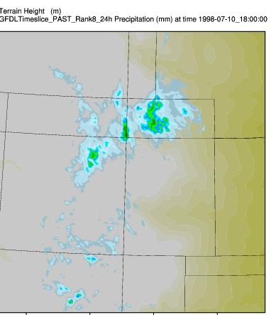
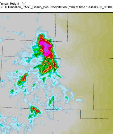
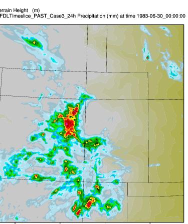
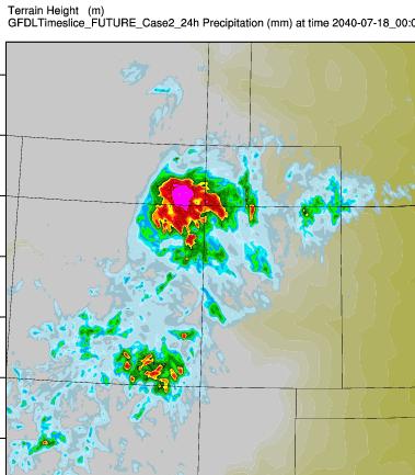
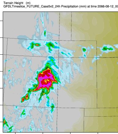
6 Three different downscaling methodologies (Overview) 1. Individual simulations 2. Composite-initialized simulations 3. Delta method/ PGW /climate-perturbed simulations of observed extreme event 1. Individual simulations: Comparison of top 10 past individual events vs. top 10 future individual events 2. Composite approach 3. Big Thompson Canyon Flood in GFDL-TS Future 24h total precip (mm)

7 WRF runs: Model set-up WRFV3.1 4km outer domain: 450x450 gridpoints 1.33 km inner domain: 574x601 gridpoints Hourly output for 24-h Parameterizations: WSM6 microphysics YSU Planetary Boundary Layer scheme RRTM, Dudhia LW/SW radiation physics Noah land surface model (4-layers) Initial conditions for runs shown here: Geophysical Fluid Dynamics Laboratory (GFDL) GCM Timeslice simulations GFDL AM2.1; 20C3M; SRES-A2 (Historical simulations not based on real events) Domain 1 (4-km) WRF Domain 2 (1.3-km) GFDL Topography over target region (m)
8 Examples of preliminary results*: 1. Individual simulations 2. Composite-initialized simulations 3. Delta method/ PGW /climate-perturbed simulations of observed extreme event *Main results shown are from one NARCCAP regional climate model dataset: the GFDL-timeslices experiment brief comparison at end
9 As seen at 50-km regional climate scale: Top 10 Past vs. Top 10 Future Events Past Top 10 1 Target region CO WRF model domain 6 Total precipitation/24h (mm, shaded), surface winds (vectors) Future Top WRF model domain 6


")


10 1TR Top 10 Past vs. Top 10 future: WRF Past Top Whole domain (Average of all 10 cases) Average precipitation FUTURE TR 6 PAST Maximum gridpoint precipitation Total precipitation/24h (mm, shaded) Future Top Total precipitation/24h (mm, shaded)

11 2. Extreme event composites as model initial conditions Past Top km WRF simulation from PAST events composite 4 5 Composite Top 9 10 PAST events 8 Create WRF initial, boundary conditions from composite fields 10 1km WRF simulation from FUTURE events composite Future Top Composite Top 10 8 events 9 FUTURE 6 7 Create 10 WRF initial, boundary conditions from composite fields

12 2. Extreme event composites as model initial conditions 1.3-km WRF simulation from PAST events composite 24-h total precip (mm) 24-h total precip (mm) 1.3-km WRF simulation from FUTURE events composite GFDL ts COMPOSITES Whole domain Average precipitation Maximum gridpoint precipitation PAST FUTURE Increase in future intensity, precipitation maxima; trends in composite results agree with averages of top 10 past, future individual events For this particular region/driving model, 1 composite-initialized model run yields similar qualitative results as 10 individual model runs: implications for resource-limited user groups? Caveat! Success of method largely dependent on signal strength in event composites (timing of extreme events, over-smoothing of initial fields may be problematic*) * WRF-CCSM composite runs not as successful


, Hara et al. (2008), Kawase et al.")
13 3. Climate Perturbation / Pseudo-Global- Warming / Delta Method Experiment * Assuming same synoptic forcing, what would an observed extreme event of the past look like with modified thermodynamics as specified by various future climate projections? Using extreme event composites, difference past and future files to define future climate anomaly for T, RH Add changes to original WRF input files; run model Using NARCCAP GFDL Composite files: Compute ΔT comp, ΔRH comp between future, past at each gridpoint, vertical level 24h total precip (mm) for Big Thompson event in GFDL-TS Future ΔT ΔRH Level (pres) 1000mb ΔT (future -past) ΔRH (future -past) Add perturbations to WRF input files; run model on perturbed data 50mb Surface *Methodology similar to Schär et al. (1996), Hara et al. (2008), Kawase et al. (2008), Hill and Lackmann (2011), and Rasmussen et al. (2011)
 Ft.")
14 Big Thompson (1976) and Fort Collins (1997) Floods: Climate Perturbed Run Big Thompson Control 24h total precip (mm) Big Thompson GFDLts Future 24h total precip (mm) Ft. Collins Control 24h total precip (mm) Ft. Collins GFDLts Future 24h total precip (mm) Observed event location shifts north; magnitude of overall maxima similar Should future climate signal be derived from shifts in uniform seasonal averages, gridpoint-based shifts on extreme-producing days only, other? Proof of concept stage: value likely lies in ability to perturb environment across wide spectrum of climate change scenarios
15 Comparison of three approaches with 50-km NARCCAP data Compare 3 approaches, NARCCAP: How do 50-km, 1.3-km simulations compare? What value is being added (if any?) Do we see the same qualitative trends? NARCCAP (GFDL-ts) Top events composite: PAST Intensity decrease NARCCAP (GFDL-ts) Top events composite: FUTURE NARCCAP (50km) 1. Individual simulations NARCCAP (50km) Future (red) Past (black) Domain-wide averages of top 10 vs. top 10 runs Future (red) Past (black) 1. Top 10 Individual Event WRF Simulation Average: PAST Intensity increase 1. Top 10 Individual Event WRF Simulation Average: FUTURE 2. Composite approach 3. Climate perturbation method Domain-wide averages of composite runs Domain-wide averages of CTRL, Future BT run 2. WRF s PAST events composite 2. WRF s Future events composite Future (red) GFDLts Perturbed Future (red) Intensity increase Past (black) CTRL (black)
16 Surprise findings? What happens to surface hail? Example of average accumulated surface graupel/hail fields in Top 10 past vs. Top 10 future individual cases Event-total (24-h) hail at the surface: Past (Average of top 10 1-km simulations from WRF- CCSM) Event-total (24-h) hail at the surface: Future (Average of top 10 1-km simulations from WRF- CCSM) Trend persists across *all* simulations: individual top events, compositebased, delta-method, *and* with GFDL-ts and WRF-CCSM Until you change the microphysics scheme Importance of model microphysics with increased downscaling!
 of Top 10 events: WRF-CCSM (red/orange = drier in future; blue/green = wetter in future) NARCCAP (50 km) GFDL-Timeslice WRF-1km (from GFDL-Timeslice) NARCCAP (50 km) WRF-CCSM")
17 Comparison of GFDL-ts, WRF-CCSM results GFDL-Timeslices WRF-CCSM Avg difference (Future Past) of Top 10 events: GFDL-Timeslices (red/orange = drier in future; blue/green = wetter in future) Avg difference (Future Past) of Top 10 events: WRF-CCSM (red/orange = drier in future; blue/green = wetter in future) NARCCAP (50 km) GFDL-Timeslice WRF-1km (from GFDL-Timeslice) NARCCAP (50 km) WRF-CCSM WRF-1km (from WRF-CCSM) Summary by region: WRF 1-km Top 10 events from GFDL-ts: Elevation analysis: Max Precip (Top 10 event averages) Summary by region: WRF 1-km Top 10 events from WRF-CCSM: Elevation analysis: Max Precip (Top 10 event averages) GFDL- Timeslices Target Region Only (Average of all 10 cases) Average precip Max precip Whole domain (Average of all 10 cases) Average precip Max precip TR-averages of top 10 vs. top 10 runs Future (red) WRF- CCSM Target Region Only (Average of all 10 cases) Average precip Maximu m precip Whole domain (Average of all 10 cases) Average precip Maximu m precip TR-averages of top 10 vs. top 10 runs Future (red) PAST FUT Past (black) PAST FUT Past (black)
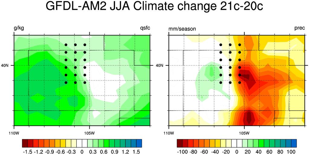
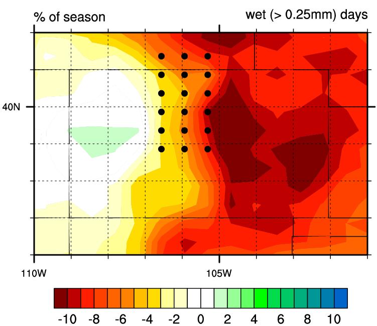
18 Preliminary conclusions 1. High-resolution simulations offer insight into past, future extreme events: spatial/temporal detail, assessment of storm-scale physical processes 2. Preliminary results (GFDL-timeslices, WRF-CCSM) suggest: more intense precipitation extremes in future, particularly ~ ft (both models) changes in hail amount at surface due to sub-cloud melting (both models) GFDL-ts wetter overall (past and future) than WRF-CCSM WRF-CCSM may have diurnal precip, QC issues: has several days with mm of precip reported, composites problematic 3. Value over RCM likely depends on objective (and geographic region, computing capabilities ) Over whole domain, average precip amounts may be similar but spatial pattern of changes reversed in high-res vs. RCM Ongoing work to establish why pattern reversal results; also differences in high- vs. low-elevation locations 4. Comparison of model methodologies underway: Composite approach may offer shortcut around individual simulations in some cases; strengths, weaknesses of all approaches to be analyzed further 5. Need (at least) one more set of NARCCAP simulations for downscaling (all methods) 50km vs. 1km? Objective?
19 Acknowledgments US Bureau of Reclamation: Dave Raff, John England, Chuck Hennig, Levi Brekke, Victoria Sankovich, Jade Soddell, Subhrendu Gangopandyah UCAR/CLIVAR/PACE program NARCCAP Project (NCAR) NCAR, National Science Foundation for WRF, NCL, wrfhelp Unidata (UCAR) for IDV, GEMPAK NOAA ESRL High-Performance Computing System Western Water Assessment (WWA) Contact: Kelly Mahoney
20
21 Extra slides
 extreme event composites Precipitation (mm/day): Top")
 Surface winds and moisture convergence Compare RCM s extreme event")
:")
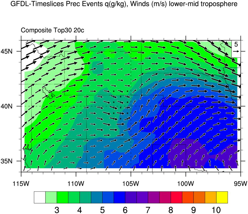
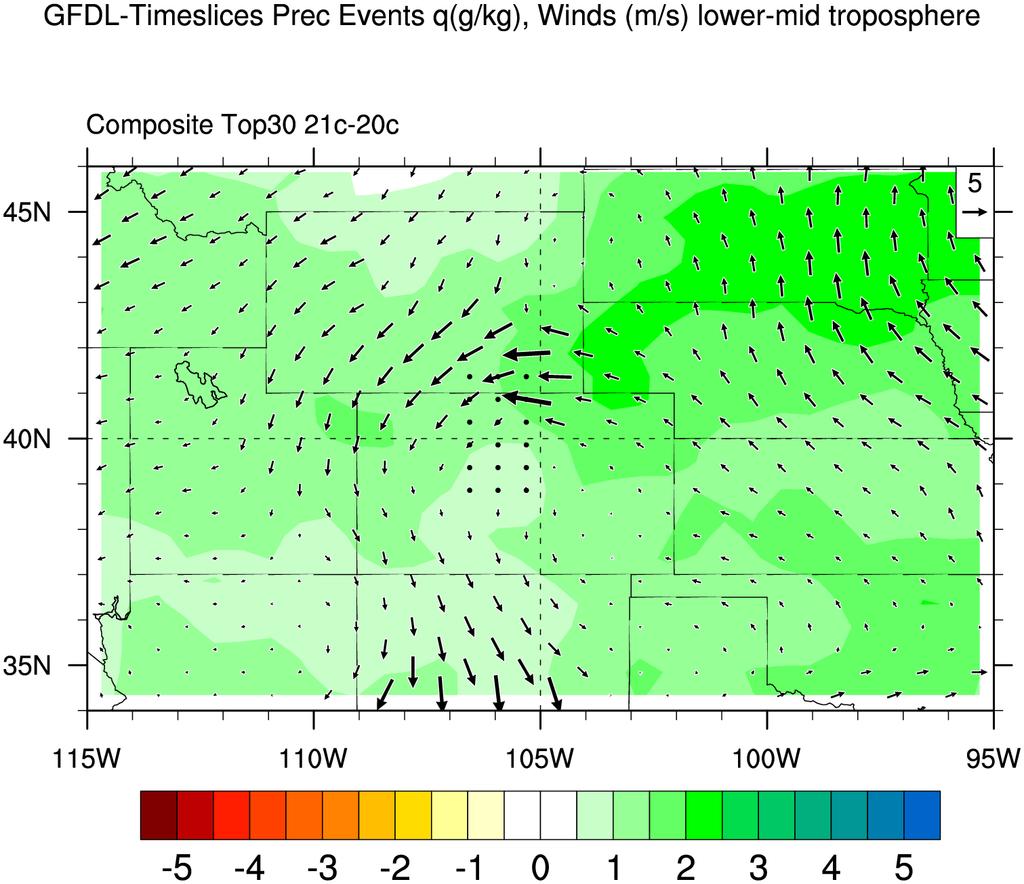
22 Case selection: Comparing NARCCAP extreme cases to extreme precipitation climatology Case selection quality control: Regional climate model (GFDL) extreme event composites Precipitation (mm/day): Top 20 th century events NARR Analysis (composites of observed extreme events from ) Precipitation (mm/day) Surface winds and moisture convergence Compare RCM s extreme event characteristics to observed extreme events (NARR) Moist, easterly (upslope) flow dominant weather pattern in both observations and models; large scale weather matches overall Precipitation (mm/day): Top 21 st century events
23 Preliminary Results: Analysis of Top 10 past events vs. Top 10 future individual events Does elevation of heaviest precipitation change from past to future? Future (red) Past (black) Domain-wide Intense precip in future simulations increases up to 9000ft (~2700m) More cases, regions to be examined Shifts in this elevation range relevant to water resource management concerns, flood/dam safety!
24 Comparison of three approaches with 50-km NARCCAP data Compare 3 approaches, NARCCAP: How do 50-km, 1.3-km simulations compare? What value is being added (if any?) Do we see the same qualitative trends? NARCCAP (GFDL-ts) Top events composite: PAST NARCCAP (GFDL-ts) Top events composite: FUTURE Intensity decrease 1. Top 10 Individual Event WRF Simulation Average: PAST 1. Top 10 Individual Event WRF Simulation Average: FUTURE 2. WRF s PAST events composite 2. WRF s Future events composite Intensity increase Intensity increase

 hail at the surface:")
 hail at the surface: Future (Average of top 10 1-km simulations")
25 Surprise findings? What happens to surface hail? Example of average accumulated surface graupel/hail fields in Top 10 past vs. Top 10 future individual cases Event-total (24-h) hail at the surface: Past (Average of top 10 1-km simulations from WRF- CCSM) Event-total (24-h) hail at the surface: Future (Average of top 10 1-km simulations from WRF- CCSM) Average freezing level height: Past Average freezing level height: Future
 of Top 10 events: WRF-CCSM (red/orange = drier in future; blue/green = wetter in future) NARCCAP (50 km) GFDL-Timeslice WRF-1km (from GFDL-Timeslice) NARCCAP (50 km) WRF-CCSM")
26 Comparison of GFDL-ts, WRF-CCSM results GFDL-Timeslices WRF-CCSM Avg difference (Future Past) of Top 10 events: GFDL-Timeslices (red/orange = drier in future; blue/green = wetter in future) Avg difference (Future Past) of Top 10 events: WRF-CCSM (red/orange = drier in future; blue/green = wetter in future) NARCCAP (50 km) GFDL-Timeslice WRF-1km (from GFDL-Timeslice) NARCCAP (50 km) WRF-CCSM WRF-1km (from WRF-CCSM) Summary by region: WRF 1-km Top 10 events from GFDL-ts: Elevation analysis (Top 10 event averages) Summary by region: WRF 1-km Top 10 events from WRF-CCSM: Elevation analysis (Top 10 event averages) GFDL- Timeslices Target Region Only (Average of all 10 cases) Average precip Max precip Whole domain (Average of all 10 cases) Average precip Max precip Domain-wide averages of top 10 Future (red) vs. top 10 runs WRF- CCSM Target Region Only (Average of all 10 cases) Average precip Maximu m precip Whole domain (Average of all 10 cases) Average precip Maximu m precip Domain-wide averages of top 10 Future (red) vs. top 10 runs PAST PAST FUT Past (black) FUT Past (black)
27 Comparison of three approaches with one another 1.Individual simulations: Top 10 past vs. top 10 future Top 10 vs. Top 10 avgs Whole domain (Average of all 10 cases) Average precipitation Maximum gridpoint precipitation PAST FUTURE Composite approach GFDL-ts COMPOSITES Whole domain Average precipitation Maximum gridpoint precipitation PAST FUTURE Climate perturbation/ delta method Big Thompson experiment Whole domain Average precipitation Maximum gridpoint precipitation PAST(CTRL) FUTURE Future (red) Domain-wide averages of top 10 vs. top 10 runs Future (red) Domain-wide averages of composite runs CTRL (black) Perturbed Future (red) Domain-wide averages of Big Thompson runs Past (black) Past (black)
28 Comparison of three approaches with 50-km NARCCAP data Compare 3 approaches NARCCAP: How does 50-km data compare to highres WRF simulations? What value is being added (if any?) in the detail? Do we see the same qualitative trends? NARCCAP (50km) NARCCAP (50km) Top 10 vs. Top 10 avgs Whole NARCCAP domain (50km) (Average of all 10 cases) Future (red) Average precipitation Past (black) Maximum gridpoint precipitation PAST FUTURE Individual simulations 2. Composite approach 3. Climate perturbation/ delta method Top 10 vs. Top 10 avgs Whole domain (Average of all 10 cases) GFDL ts COMPOSITES Whole domain BT run Whole domain Average precipitation Maximum gridpoint precipitation PAST FUTURE Average precipitatio n Maximum gridpoint precipitation PAST FUTURE Average precipitation Maximum gridpoint precipitation PAST (CTRL) FUTURE
29 Data details NARCCAP: North American Region Climate Change Assessment Program Uses large scale forcing from 20th century and 21st century climate change (SRES A2) AOGCM experiments to force high resolution regional climate models. GFDL-AM2 (timeslice) Observed SST/Sea-ice/GHG forcing for 20 th C Anomalous SST/Sea-ice/GHG from SRES A2 in 21 st C run Run atmosphere-only model at high res with prescribed BC (no regional model used) WRF-CCSM Update WRF-CCSM detailsc Examine daily average (12UTC-12UTC) Precipitation from NARCCAP: 20th century ( ) 21st century ( ) Warm season (June-July-August)


:")


30 GFDL-ts vs. WRF-CCSM (top 10 case average): 2m-Temp Past Future Difference (ΔT) GFDLts WRF- CCSM


: 2m-MIXR Past Future")
31 Plot using narccap instead make sure this isn t a WRF interpolation thing! GFDL-ts vs. WRF-CCSM (top 10 case average at F00): 2m-MIXR Past Future Difference (ΔT) GFDLts WRF- CCSM
32 GFDL-ts vs. WRF-CCSM (top 10 case average at F00): 2m-MIXR Past Future Difference (ΔT) These are top 30 do top 10 w/ same color scale as with wrf GFDLts WRF- CCSM

")
")
33 GFDL-ts vs. WRF-CCSM (top 10 case average): Precip (from WRF) Past Future Difference (ΔT) GFDLts WRF- CCSM
34 GFDL-ts vs. WRF-CCSM (top 10 case average): Precip (from NARCCAP) Past Future Difference (ΔT) These are top 30 do top 10 w/ same color scale as with wrf GFDLts WRF- CCSM
35 GFDL-ts vs. WRF-CCSM (top 10 case average): Precipitable Water Add same thing for PW, CAPE
36 Targeted Composite Technique Target region (TR): Colorado Front Range 38.5N-41.5N, 106.5W-105W Identify model grid points in TR Sort all Daily Prec values from JJA in TR Find top 30 Prec values from unique events Average prec, sfc hum, sfc winds and other fields (when avail) from each event Colorado


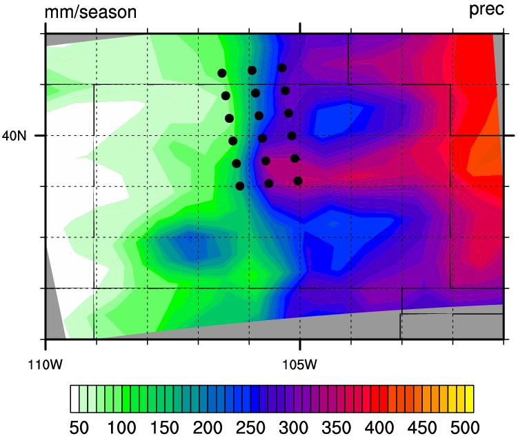

37 Mean Summer (JJA) Precip GFDL-AM2 HADCM3-HRM3 GFDL-RCM3 CGCM3-RCM3
38
39
40
41
42
43
44

45

46 WRF vs. GFDL Topography
47 To delete
48 Big Thompson Climate Perturbed Run Big Thompson Control Simulated radar reflectivity (dbz) Big Thompson GFDLts Future Simulated radar reflectivity (dbz)


49 How can Reclamation use these results? Feedback from USBR water resources managers: Want to understand elevation threshold of extreme precipitation: Present precipitation-elevation thresholds? Future changes? Help generate future-climate scenarios for emergency preparedness exercises Incorporate results into dam safety evaluations, USBR Early Warning System operations, community/risk analysis, floodplain re-mapping Challenges: Adapting findings from atmospheric science/wrf framework to hydrologic/water management framework Language/jargon, units, technology, time Early Warning System (USBR) gauge station Collaborative field learning Olympus Dam, Estes Park, CO
Using a high-resolution ensemble modeling method to inform risk-based decision-making at Taylor Park Dam, Colorado
 Using a high-resolution ensemble modeling method to inform risk-based decision-making at Taylor Park Dam, Colorado Michael J. Mueller 1, Kelly Mahoney 2, Kathleen Holman 3, David Gochis 4 1 Cooperative
CCRN Year 3 Results and Update on Progress Summer Storms and Convective Precipitation
 CCRN Year 3 Results and Update on Progress Summer Storms and Convective Precipitation John Hanesiak Department of Environment & Geography Centre for Earth Observation Science (CEOS) Faculty of Environment,
Pseudo-Global warming approach using 4KM WRF model
 Pseudo-Global warming approach using 4KM WRF model S. Kurkute 1,2 Y. Li 1,2 1 School of Environment and Sustainability University of Saskatchewan 2 Global Institute of Water Security University of Saskatchewan
Southern New England s Changing Climate. Raymond S. Bradley and Liang Ning Northeast Climate Science Center University of Massachusetts, Amherst
 Southern New England s Changing Climate Raymond S. Bradley and Liang Ning Northeast Climate Science Center University of Massachusetts, Amherst Historical perspective (instrumental data) IPCC scenarios
A 21st century HRRR-based approach to estimating probable maximum precipitation to enhance dam safety and community resilience
 30 May 2017 FIRO Science Task Group Workshop A 21st century HRRR-based approach to estimating probable maximum precipitation to enhance dam safety and community resilience Courtesy Bill McCormick, Chief,
Kelly Mahoney NOAA ESRL Physical Sciences Division
 The role of gray zone convective model physics in highresolution simulations of the 2013 Colorado Front Range Flood WRF model simulated precipitation over terrain in CO Front Range Kelly Mahoney NOAA ESRL
Model resolution impact on Precipitation: Comparison to SNOTEL observations
 Model resolution impact on Precipitation: Comparison to SNOTEL observations 5/7/2012 40 proj. updates Sensitivity to model grid resolution: Precipitation from the 8-year Current Climate Simulation Percent
Mesoscale Convective Systems Under Climate Change
 North American Scale Convection-Permitting Climate Modeling Mesoscale Convective Systems Under Climate Change AF Prein, K Ikeda, C Liu, R Rasmussen, R Bullock, S Trier, GJ Holland, M Clark RAL Retreat,
WRF Historical and PGW Simulations over Alaska
 WRF Historical and PGW Simulations over Alaska Andrew J. Newman 1, Andrew J. Monaghan 2, Martyn P. Clark 1, Kyoko Ikeda 1, Lulin Xue 1, and Jeff R. Arnold 3 GEWEX CPCM Workshop II 1 National Center for
Statistical analysis of regional climate models. Douglas Nychka, National Center for Atmospheric Research
 Statistical analysis of regional climate models. Douglas Nychka, National Center for Atmospheric Research National Science Foundation Olso workshop, February 2010 Outline Regional models and the NARCCAP
Projected change in the East Asian summer monsoon from dynamical downscaling
 Copyright KIOST, ALL RIGHTS RESERVED. Projected change in the East Asian summer monsoon from dynamical downscaling : Moisture budget analysis Chun-Yong Jung 1,2, Chan Joo Jang 1*, Ho-Jeong Shin 1 and Hyung-Jin
North American Regional Climate Change Assessment Program
 North American Regional Climate Change Assessment Program Toni Rosati IMAGe NCAR narccap@ucar.edu Outline Basic concepts of numerical climate modeling NetCDF data format overview NARCCAP project NARCCAP
Julie A. Winkler. Raymond W. Arritt. Sara C. Pryor. Michigan State University. Iowa State University. Indiana University
 Julie A. Winkler Michigan State University Raymond W. Arritt Iowa State University Sara C. Pryor Indiana University Summarize by climate variable potential future changes in the Midwest as synthesized
Training: Climate Change Scenarios for PEI. Training Session April Neil Comer Research Climatologist
 Training: Climate Change Scenarios for PEI Training Session April 16 2012 Neil Comer Research Climatologist Considerations: Which Models? Which Scenarios?? How do I get information for my location? Uncertainty
On the Appropriateness of Spectral Nudging in Regional Climate Models
 On the Appropriateness of Spectral Nudging in Regional Climate Models Christopher L. Castro Department of Atmospheric Sciences University of Arizona Tucson, Arizona, USA Dynamically Downscaled IPCC model
Diagnosing the Climatology and Interannual Variability of North American Summer Climate with the Regional Atmospheric Modeling System (RAMS)
") Diagnosing the Climatology and Interannual Variability of North American Summer Climate with the Regional Atmospheric Modeling System (RAMS) Christopher L. Castro and Roger A. Pielke, Sr. Department of
Diagnosing the Climatology and Interannual Variability of North American Summer Climate with the Regional Atmospheric Modeling System (RAMS) Christopher L. Castro and Roger A. Pielke, Sr. Department of
Projected Impacts of Climate Change in Southern California and the Western U.S.
 Projected Impacts of Climate Change in Southern California and the Western U.S. Sam Iacobellis and Dan Cayan Scripps Institution of Oceanography University of California, San Diego Sponsors: NOAA RISA
INTRODUCTION HAZARDOUS CONVECTIVE WEATHER (HCW)
") CLIMATE CHANGE AND HAZARDOUS CONVECTIVE WEATHER IN THE UNITED STATES: INSIGHT FROM HIGH-RESOLUTION DYNAMICAL DOWNSCALING GEWEX WORKSHOP Kimberly Hoogewind 1,2, Jeff Trapp 2, and Mike Baldwin 1 1 Purdue
CLIMATE CHANGE AND HAZARDOUS CONVECTIVE WEATHER IN THE UNITED STATES: INSIGHT FROM HIGH-RESOLUTION DYNAMICAL DOWNSCALING GEWEX WORKSHOP Kimberly Hoogewind 1,2, Jeff Trapp 2, and Mike Baldwin 1 1 Purdue
High-Resolution MPAS Simulations for Analysis of Climate Change Effects on Weather Extremes
 High-Resolution MPAS Simulations for Analysis of Climate Change Effects on Weather Extremes ALLISON MICHAELIS, GARY LACKMANN, & WALT ROBINSON Department of Marine, Earth, and Atmospheric Sciences, North
Climate Modeling: From the global to the regional scale
 Climate Modeling: From the global to the regional scale Filippo Giorgi Abdus Salam ICTP, Trieste, Italy ESA summer school on Earth System Monitoring and Modeling Frascati, Italy, 31 July 11 August 2006
Greenhouse Gas Induced Changes in Summer Precipitation over Colorado in NARCCAP Regional Climate Models*
 8690 J O U R N A L O F C L I M A T E VOLUME 26 Greenhouse Gas Induced Changes in Summer Precipitation over Colorado in NARCCAP Regional Climate Models* MICHAEL A. ALEXANDER NOAA/Earth System Research Laboratory,
Intensity-Duration-Frequency Curve Update for Newfoundland and Labrador
 Intensity-Duration-Frequency Curve Update for Newfoundland and Labrador Allyson Bingeman 1 Juraj Cunderlik 1 Gerald Crane 2 Amir Ali Khan 3 1 GHD Limited 2 Office of Climate Change and Energy Efficiency
A COMPARISON OF VERY SHORT-TERM QPF S FOR SUMMER CONVECTION OVER COMPLEX TERRAIN AREAS, WITH THE NCAR/ATEC WRF AND MM5-BASED RTFDDA SYSTEMS
 A COMPARISON OF VERY SHORT-TERM QPF S FOR SUMMER CONVECTION OVER COMPLEX TERRAIN AREAS, WITH THE NCAR/ATEC WRF AND MM5-BASED RTFDDA SYSTEMS Wei Yu, Yubao Liu, Tom Warner, Randy Bullock, Barbara Brown and
Combining Deterministic and Probabilistic Methods to Produce Gridded Climatologies
 Combining Deterministic and Probabilistic Methods to Produce Gridded Climatologies Michael Squires Alan McNab National Climatic Data Center (NCDC - NOAA) Asheville, NC Abstract There are nearly 8,000 sites
Use of the Combined Pacific Variability Mode for Climate Prediction in North America
 Use of the Combined Pacific Variability Mode for Climate Prediction in North America Christopher L. Castro,, Stephen Bieda III, and Francina Dominguez University of Arizona Regional Climate Forum for Northwest
High resolution rainfall projections for the Greater Sydney Region
 20th International Congress on Modelling and Simulation, Adelaide, Australia, 1 6 December 2013 www.mssanz.org.au/modsim2013 High resolution rainfall projections for the Greater Sydney Region F. Ji a,
The North American Regional Climate Change Assessment Program (NARCCAP) Raymond W. Arritt for the NARCCAP Team Iowa State University, Ames, Iowa USA
 Raymond W. Arritt for the NARCCAP Team Iowa State University, Ames, Iowa USA") The North American Regional Climate Change Assessment Program (NARCCAP) Raymond W. Arritt for the NARCCAP Team Iowa State University, Ames, Iowa USA NARCCAP Participants Raymond Arritt, David Flory, William
The North American Regional Climate Change Assessment Program (NARCCAP) Raymond W. Arritt for the NARCCAP Team Iowa State University, Ames, Iowa USA NARCCAP Participants Raymond Arritt, David Flory, William
Cooperative Institute for Research in Environmental Sciences (CIRES) CU-Boulder 2. National Oceanic and Atmospheric Administration
 CU-Boulder 2. National Oceanic and Atmospheric Administration") Moisture transport during the inland penetrating atmospheric river of early November 006 in the Pacific Northwest: A high-resolution model-based study Michael J. Mueller 1 and Kelly Mahoney 1 Cooperative
Moisture transport during the inland penetrating atmospheric river of early November 006 in the Pacific Northwest: A high-resolution model-based study Michael J. Mueller 1 and Kelly Mahoney 1 Cooperative
Northern New England Climate: Past, Present, and Future. Basic Concepts
 Northern New England Climate: Past, Present, and Future Basic Concepts Weather instantaneous or synoptic measurements Climate time / space average Weather - the state of the air and atmosphere at a particular
Water Balance in the Murray-Darling Basin and the recent drought as modelled with WRF
 18 th World IMACS / MODSIM Congress, Cairns, Australia 13-17 July 2009 http://mssanz.org.au/modsim09 Water Balance in the Murray-Darling Basin and the recent drought as modelled with WRF Evans, J.P. Climate
Artificial Neural Network Prediction of Future Rainfall Intensity
 Ryan Patrick McGehee Dr. Puneet Srivastava Artificial Neural Network Prediction of Future Rainfall Intensity A Precursor to Understanding Climate Change Outcomes for the Southeastern United States Why
Christopher L. Castro Department of Atmospheric Sciences University of Arizona Tucson, Arizona, USA
 Creating dynamically downscaled seasonal climate forecast and climate projection information for the North American Monsoon region suitable for decision making purposes Christopher L. Castro Department
The western Canada high resolution WRF simulation
 The western Canada high resolution WRF simulation Yanping Li S. Kurkute E. Asong L. Chen University of Saskatchewan CCRN SOAP Yanping Li, S. Kurkute, E. Asong, L. Chen High Resolution WRF-RCM October 3,
Funding provided by NOAA Sectoral Applications Research Project CLIMATE. Basic Climatology Colorado Climate Center
 Funding provided by NOAA Sectoral Applications Research Project CLIMATE Basic Climatology Colorado Climate Center Remember These? Factor 1: Our Energy Source Factor 2: Revolution & Tilt Factor 3: Rotation!
Use of Emerging Applications of the Weather Research and Forecasting Model to Investigate the North American Monsoon
 Use of Emerging Applications of the Weather Research and Forecasting Model to Investigate the North American Monsoon Christopher L. Castro, Francina Dominguez, and Stephen Bieda III, Department of Atmospheric
Fine-scale climate projections for Utah from statistical downscaling of global climate models
 Fine-scale climate projections for Utah from statistical downscaling of global climate models Thomas Reichler Department of Atmospheric Sciences, U. of Utah thomas.reichler@utah.edu Three questions A.
Sensitivity of precipitation forecasts to cumulus parameterizations in Catalonia (NE Spain)
") Sensitivity of precipitation forecasts to cumulus parameterizations in Catalonia (NE Spain) Jordi Mercader (1), Bernat Codina (1), Abdelmalik Sairouni (2), Jordi Cunillera (2) (1) Dept. of Astronomy and
Sensitivity of precipitation forecasts to cumulus parameterizations in Catalonia (NE Spain) Jordi Mercader (1), Bernat Codina (1), Abdelmalik Sairouni (2), Jordi Cunillera (2) (1) Dept. of Astronomy and
Downscaling ability of the HadRM3P model over North America
 Downscaling ability of the HadRM3P model over North America Wilfran Moufouma-Okia and Richard Jones Crown copyright Met Office Acknowledgments Special thanks to the Met Office Hadley Centre staff in the
CLIMATE MODEL DOWNSCALING: HOW DOES IT WORK AND WHAT DOES IT TELL YOU?
 rhgfdjhngngfmhgmghmghjmghfmf CLIMATE MODEL DOWNSCALING: HOW DOES IT WORK AND WHAT DOES IT TELL YOU? YAN FENG, PH.D. Atmospheric and Climate Scientist Environmental Sciences Division Argonne National Laboratory
Yuqing Wang. International Pacific Research Center and Department of Meteorology University of Hawaii, Honolulu, HI 96822
 A Regional Atmospheric Inter-Model Evaluation Project (RAIMEP) with the Focus on Sub-daily Variation of Clouds and Precipitation Yuqing Wang International Pacific Research Center and Department of Meteorology
Climate Change and Runoff Statistics in the Rhine Basin: A Process Study with a Coupled Climate-Runoff Model
 IACETH Climate Change and Runoff Statistics in the Rhine Basin: A Process Study with a Coupled Climate-Runoff Model Jan KLEINN, Christoph Frei, Joachim Gurtz, Pier Luigi Vidale, and Christoph Schär Institute
Erik Kabela and Greg Carbone, Department of Geography, University of South Carolina
 Downscaling climate change information for water resources Erik Kabela and Greg Carbone, Department of Geography, University of South Carolina As decision makers evaluate future water resources, they often
Regional Climate Simulations with WRF Model
 WDS'3 Proceedings of Contributed Papers, Part III, 8 84, 23. ISBN 978-8-737852-8 MATFYZPRESS Regional Climate Simulations with WRF Model J. Karlický Charles University in Prague, Faculty of Mathematics
Uncertainty and regional climate experiments
 Uncertainty and regional climate experiments Stephan R. Sain Geophysical Statistics Project Institute for Mathematics Applied to Geosciences National Center for Atmospheric Research Boulder, CO Linda Mearns,
Indices of droughts over Canada as simulated by a statistical downscaling model: current and future periods
 Indices of droughts over Canada as simulated by a statistical downscaling model: current and future periods Philippe Gachon 1, Rabah Aider 1 & Grace Koshida Adaptation & Impacts Research Section, Climate
Development and Validation of Polar WRF
 Polar Meteorology Group, Byrd Polar Research Center, The Ohio State University, Columbus, Ohio Development and Validation of Polar WRF David H. Bromwich 1,2, Keith M. Hines 1, and Le-Sheng Bai 1 1 Polar
NARCCAP and NetCDF. Seth McGinnis & Toni Rosati IMAGe NCAR.
 NARCCAP and NetCDF Seth McGinnis & Toni Rosati IMAGe NCAR narccap@ucar.edu Outline NARCCAP overview Program goals How NARCCAP data is used How netcdf supports NARCCAP Geo-oriented data model Integrated
Climate Change: Mesoscale and Synoptic- Scale Precipitation Events
 Climate Change: Mesoscale and Synoptic- Scale Precipitation Events Gary Lackmann, North Carolina State University Collaborators: M. Cipullo, J. Willison, M. Mallard, W. Robinson CLIVAR Workshop on LSMPs
Forecasts for the Future: Understanding Climate Models and Climate Projections for the 21 st Century
 Forecasts for the Future: Understanding Climate Models and Climate Projections for the 21 st Century Linda E. Sohl NASA Goddard Institute for Space Studies and the Center for Climate Systems Reseearch
Downscaling and Probability
 Downscaling and Probability Applications in Climate Decision Aids May 11, 2011 Glenn Higgins Manager, Environmental Sciences and Engineering Department Downscaling and Probability in Climate Modeling The
NIDIS Intermountain West Regional Drought Early Warning System February 7, 2017
 NIDIS Drought and Water Assessment NIDIS Intermountain West Regional Drought Early Warning System February 7, 2017 Precipitation The images above use daily precipitation statistics from NWS COOP, CoCoRaHS,
Climate Change and the Chehalis River. Guillaume Mauger, Se-Yeun Lee, Christina Bandaragoda, Yolande Serra, and Jason Won September 21, 2016
 Climate Change and the Chehalis River Guillaume Mauger, Se-Yeun Lee, Christina Bandaragoda, Yolande Serra, and Jason Won September 21, 2016 Background: General Approach to Climate Impacts Assessment Global
Regional Climate Modeling Technology: Initial Results Regional Climate Modeling Consortium. Cliff Mass. UW, WSAS Member
 Regional Climate Modeling Technology: Initial Results Regional Climate Modeling Consortium Cliff Mass UW, WSAS Member Regional Climate Modeling for Washington State Cliff Mass Department of Atmospheric
Regionalization Techniques and Regional Climate Modelling
 Regionalization Techniques and Regional Climate Modelling Joseph D. Intsiful CGE Hands-on training Workshop on V & A, Asuncion, Paraguay, 14 th 18 th August 2006 Crown copyright Page 1 Objectives of this
8-km Historical Datasets for FPA
 Program for Climate, Ecosystem and Fire Applications 8-km Historical Datasets for FPA Project Report John T. Abatzoglou Timothy J. Brown Division of Atmospheric Sciences. CEFA Report 09-04 June 2009 8-km
Canadian Meteorological and Oceanographic Society and American Meteorological Society 21 st Conference on Numerical Weather Prediction 31 May 2012
 Canadian Meteorological and Oceanographic Society and American Meteorological Society 21 st Conference on Numerical Weather Prediction 31 May 2012 The High Resolution Rapid Refresh (): An hourly updating
Hydrologic Research Laboratory Department of Civil and Environmental Engineering University of California, Davis
 Physically-Based Estimation of Maximum Precipitation: Preliminary Results on Application to American River Basin for the December,1996-January,1997 Flood Event Hydrologic Research Laboratory Department
Anticipated and Observed Trends in the Global Hydrological Cycle. Kevin E. Trenberth NCAR
 Anticipated and Observed Trends in the Global Hydrological Cycle Kevin E. Trenberth NCAR The presence of moisture affects the disposition of incoming solar radiation: Evaporation (drying) versus temperature
A WRF-based rapid updating cycling forecast system of. BMB and its performance during the summer and Olympic. Games 2008
 A WRF-based rapid updating cycling forecast system of BMB and its performance during the summer and Olympic Games 2008 Min Chen 1, Shui-yong Fan 1, Jiqin Zhong 1, Xiang-yu Huang 2, Yong-Run Guo 2, Wei
1. Introduction. In following sections, a more detailed description of the methodology is provided, along with an overview of initial results.
 7B.2 MODEL SIMULATED CHANGES IN TC INTENSITY DUE TO GLOBAL WARMING Kevin A. Hill*, Gary M. Lackmann, and A. Aiyyer North Carolina State University, Raleigh, North Carolina 1. Introduction The impact of
Areal Reduction Factors for the Colorado Front Range and Analysis of the September 2013 Colorado Storm
 Areal Reduction Factors for the Colorado Front Range and Analysis of the September 2013 Colorado Storm Doug Hultstrand, Bill Kappel, Geoff Muhlestein Applied Weather Associates, LLC - Monument, Colorado
Future extreme precipitation events in the Southwestern US: climate change and natural modes of variability
 Future extreme precipitation events in the Southwestern US: climate change and natural modes of variability Francina Dominguez Erick Rivera Fernandez Hsin-I Chang Christopher Castro AGU 2010 Fall Meeting
Exploring the Use of Dynamical Weather and Climate Models for Risk Assessment
 Exploring the Use of Dynamical Weather and Climate Models for Risk Assessment James Done Willis Research Network Fellow National Center for Atmospheric Research Boulder CO, US Leverages resources in the
2010 CAPS Spring Forecast Experiment Program Plan (A Brief Version)
") 21 CAPS Spring Forecast Experiment Program Plan (A Brief Version) May 17, 21 Table of Content Table of Content... 2 1. Overview of New Features for 21 Season... 3 2. Program Duration... 4 3. Forecast System
21 CAPS Spring Forecast Experiment Program Plan (A Brief Version) May 17, 21 Table of Content Table of Content... 2 1. Overview of New Features for 21 Season... 3 2. Program Duration... 4 3. Forecast System
APPLICATIONS OF DOWNSCALING: HYDROLOGY AND WATER RESOURCES EXAMPLES
 APPLICATIONS OF DOWNSCALING: HYDROLOGY AND WATER RESOURCES EXAMPLES Dennis P. Lettenmaier Department of Civil and Environmental Engineering For presentation at Workshop on Regional Climate Research NCAR
High Resolution Ensemble Prediction of Typhoon Morakot (2009) May 11, 2011
 May 11, 2011") High Resolution Ensemble Prediction of Typhoon Morakot (2009) Ying-Hwa Kuo 1,* and Xingqin Fang 1,2 1 National Center for Atmospheric Research, Boulder, Colorado, USA 2 Department of Atmospheric Sciences,
High Resolution Ensemble Prediction of Typhoon Morakot (2009) Ying-Hwa Kuo 1,* and Xingqin Fang 1,2 1 National Center for Atmospheric Research, Boulder, Colorado, USA 2 Department of Atmospheric Sciences,
Assessment of Ensemble Forecasts
 Assessment of Ensemble Forecasts S. L. Mullen Univ. of Arizona HEPEX Workshop, 7 March 2004 Talk Overview Ensemble Performance for Precipitation Global EPS and Mesoscale 12 km RSM Biases, Event Discrimination
Future population exposure to US heat extremes
 Outline SUPPLEMENTARY INFORMATION DOI: 10.1038/NCLIMATE2631 Future population exposure to US heat extremes Jones, O Neill, McDaniel, McGinnis, Mearns & Tebaldi This Supplementary Information contains additional
Presented at the NADP Technical Meeting and Scientific Symposium October 16, 2008
 Future Climate Scenarios, Atmospheric Deposition and Precipitation Uncertainty Alice B. Gilliland, Kristen Foley, Chris Nolte, and Steve Howard Atmospheric Modeling Division, National Exposure Research
The Developmental Testbed Center (DTC) Steve Koch, NOAA/FSL
 Steve Koch, NOAA/FSL") The Developmental Testbed Center (DTC) Steve Koch, NOAA/FSL A facility where the NWP research and operational communities interact to accelerate testing and evaluation of new models and techniques for
The Developmental Testbed Center (DTC) Steve Koch, NOAA/FSL A facility where the NWP research and operational communities interact to accelerate testing and evaluation of new models and techniques for
Christopher L. Castro Department of Atmospheric Sciences University of Arizona
 Spatiotemporal Variability and Covariability of Temperature, Precipitation, Soil Moisture, and Vegetation in North America for Regional Climate Model Applications Christopher L. Castro Department of Atmospheric
Model Based Climate Predictions for Utah. Thomas Reichler Department of Atmospheric Sciences, U. of Utah
 Model Based Climate Predictions for Utah Thomas Reichler Department of Atmospheric Sciences, U. of Utah thomas.reichler@utah.edu Climate Model Prediction Results Northern Utah: Precipitation will increase
Nesting large-eddy simulations within mesoscale simulations in WRF for wind energy applications
 Performance Measures x.x, x.x, and x.x Nesting large-eddy simulations within mesoscale simulations in WRF for wind energy applications Julie K. Lundquist Jeff Mirocha, Branko Kosović 9 WRF User s Workshop,
Adaptation by Design: The Impact of the Changing Climate on Infrastructure
 Adaptation by Design: The Impact of the Changing Climate on Infrastructure Heather Auld, J Klaassen, S Fernandez, S Eng, S Cheng, D MacIver, N Comer Adaptation and Impacts Research Division Environment
Future Great Lakes climatology and water levels simulated using Regional Climate Models
 Future Great Lakes climatology and water levels simulated using Regional Climate Models Frank Seglenieks Environment Canada The St. Clair River Symposium Port Huron, MI 2014-09-18 Summary Great Lakes hydroclimatology
Climate Summary for the Northern Rockies Adaptation Partnership
 Climate Summary for the Northern Rockies Adaptation Partnership Compiled by: Linda Joyce 1, Marian Talbert 2, Darrin Sharp 3, John Stevenson 4 and Jeff Morisette 2 1 USFS Rocky Mountain Research Station
ClimateBC version history
 ClimateBC version history ClimateBC v5.60 (August 31, 2018) Improvements Historical monthly data from the Climate Research Unit (CRU ts4.01) for the years 1999-2016 have been replaced by our newly developed
Appendix E. OURANOS Climate Change Summary Report
 Appendix E OURANOS Climate Change Summary Report Production of Climate Scenarios for Pilot Project and Case Studies The protocol developed for assessing the vulnerability of infrastructure requires data
HIGH-RESOLUTION CLIMATE PROJECTIONS everyone wants them, how do we get them? KATHARINE HAYHOE
 HIGH-RESOLUTION CLIMATE PROJECTIONS everyone wants them, how do we get them? KATHARINE HAYHOE TEXAS TECH UNIVERSITY ATMOS RESEARCH We produce heat-trapping gases THE CLIMATE PROBLEM INCREASING GHG EMISSIONS
Climate Change Scenarios in Southern California. Robert J. Allen University of California, Riverside Department of Earth Sciences
 Climate Change Scenarios in Southern California Robert J. Allen University of California, Riverside Department of Earth Sciences Overview Climatology of Southern California Temperature and precipitation
Improved rainfall and cloud-radiation interaction with Betts-Miller-Janjic cumulus scheme in the tropics
 Improved rainfall and cloud-radiation interaction with Betts-Miller-Janjic cumulus scheme in the tropics Tieh-Yong KOH 1 and Ricardo M. FONSECA 2 1 Singapore University of Social Sciences, Singapore 2
3B.3: Climate Controls on the Extreme Rainstorms in the Contiguous US:
 97 th AMS Annual Meeting 3B.3: Climate Controls on the Extreme Rainstorms in the Contiguous US: 1979-2015 Xiaodong Chen and Faisal Hossain Department of Civil and Environmental Engineering University of
Annex I to Target Area Assessments
 Baltic Challenges and Chances for local and regional development generated by Climate Change Annex I to Target Area Assessments Climate Change Support Material (Climate Change Scenarios) SWEDEN September
Future hail characteristics using HAILCAST and well-behaved dynamically downscaled regional climate models
 Future hail characteristics using HAILCAST and well-behaved dynamically downscaled regional climate models By Julian Brimelow, William Burrows and John Hanesiak Meteorologist Operational Internship Program
Possible Applications of Deep Neural Networks in Climate and Weather. David M. Hall Assistant Research Professor Dept. Computer Science, CU Boulder
 Possible Applications of Deep Neural Networks in Climate and Weather David M. Hall Assistant Research Professor Dept. Computer Science, CU Boulder Quick overview of climate and weather models Weather models
ROCKY MOUNTAIN CLIMATE
 future PRECIPITATION in the denver MEtRO AREA By Stephen Saunders, Tom Easley, and Melissa Mezger A report by the Rocky Mountain Climate Organization To Denver Environmental Health June 2017 the ROCKY
A Comparison of Statistical and Dynamical Downscaling of Winter Precipitation over Complex Terrain
 262 J O U R N A L O F C L I M A T E VOLUME 25 A Comparison of Statistical and Dynamical Downscaling of Winter Precipitation over Complex Terrain ETHAN D. GUTMANN Research Applications Laboratory, and Advanced
An Evaluation of Seeding Effectiveness in the Central Colorado Mountains River Basins Weather Modification Program
 2016, UCAR. All rights reserved. An Evaluation of Seeding Effectiveness in the Central Colorado Mountains River Basins Weather Modification Program for Grand River Consulting Sponsors: Colorado Water Conservation
Applications/Users for Improved S2S Forecasts
 Applications/Users for Improved S2S Forecasts Nolan Doesken Colorado Climate Center Colorado State University WSWC Precipitation Forecasting Workshop June 7-9, 2016 San Diego, CA First -- A short background
Sierra Weather and Climate Update
 Sierra Weather and Climate Update 2014-15 Kelly Redmond Western Regional Climate Center Desert Research Institute Reno Nevada Yosemite Hydroclimate Workshop Yosemite Valley, 2015 October 8-9 Percent of
A Quick Report on a Dynamical Downscaling Simulation over China Using the Nested Model
 ATMOSPHERIC AND OCEANIC SCIENCE LETTERS, 2010, VOL. 3, NO. 6, 325 329 A Quick Report on a Dynamical Downscaling Simulation over China Using the Nested Model YU En-Tao 1,2,3, WANG Hui-Jun 1,2, and SUN Jian-Qi
Added Value of Convection Resolving Climate Simulations (CRCS)
") Added Value of Convection Resolving Climate Simulations (CRCS) Prein Andreas, Gobiet Andreas, Katrin Lisa Kapper, Martin Suklitsch, Nauman Khurshid Awan, Heimo Truhetz Wegener Center for Climate and Global
Added Value of Convection Resolving Climate Simulations (CRCS) Prein Andreas, Gobiet Andreas, Katrin Lisa Kapper, Martin Suklitsch, Nauman Khurshid Awan, Heimo Truhetz Wegener Center for Climate and Global
Areal Reduction Factors for the Colorado Front Range and Analysis of the September 2013 Colorado Storm
 Areal Reduction Factors for the Colorado Front Range and Analysis of the September 2013 Colorado Storm Doug Hultstrand, Bill Kappel, Geoff Muhlestein Applied Weather Associates, LLC - Monument, Colorado
Drought Monitoring with Hydrological Modelling
 st Joint EARS/JRC International Drought Workshop, Ljubljana,.-5. September 009 Drought Monitoring with Hydrological Modelling Stefan Niemeyer IES - Institute for Environment and Sustainability Ispra -
Forecasting of Optical Turbulence in Support of Realtime Optical Imaging and Communication Systems
 Forecasting of Optical Turbulence in Support of Realtime Optical Imaging and Communication Systems Randall J. Alliss and Billy Felton Northrop Grumman Corporation, 15010 Conference Center Drive, Chantilly,
Extreme precipitation events in the. southeast U.S.
 Extreme precipitation events in the Southeast US A preliminary investigation of operational forecast challenges related to moisture sources and transport TN flooding May 2010 Asheville, NC 2004 State Climate
Influence of variations in low-level moisture and soil moisture on the organization of summer convective systems in the US Midwest
 Influence of variations in low-level moisture and soil moisture on the organization of summer convective systems in the US Midwest Jimmy O. Adegoke 1, Sajith Vezhapparambu 1, Christopher L. Castro 2, Roger
4.4 EVALUATION OF AN IMPROVED CONVECTION TRIGGERING MECHANISM IN THE NCAR COMMUNITY ATMOSPHERE MODEL CAM2 UNDER CAPT FRAMEWORK
 . EVALUATION OF AN IMPROVED CONVECTION TRIGGERING MECHANISM IN THE NCAR COMMUNITY ATMOSPHERE MODEL CAM UNDER CAPT FRAMEWORK Shaocheng Xie, James S. Boyle, Richard T. Cederwall, and Gerald L. Potter Atmospheric
Numerical Experiments of Tropical Cyclone Seasonality over the Western North Pacific
 Numerical Experiments of Tropical Cyclone Seasonality over the Western North Pacific Dong-Kyou Lee School of Earth and Environmental Sciences Seoul National University, Korea Contributors: Suk-Jin Choi,
Regional climate model projections for the State of Washington
 Climatic Change (2010) 102:51 75 DOI 10.1007/s10584-010-9849-y Regional climate model projections for the State of Washington Eric P. Salathé Jr. L. Ruby Leung Yun Qian Yongxin Zhang Received: 4 June 2009