WJEC 2014 Online Exam Review
|
|
|
- Sophie Taylor
- 6 years ago
- Views:
Transcription
1 WJEC 2014 Online Exam Review GCSE Geography B Unit 1 Higher All Candidates' performance across questions Question Title N Mean S D Max Mark F F Attempt % 1 (a) (b) (c) (d) (e) (e) SPaG (a) (b) (c) (d) (e) SPaG GCSE Geography B Unit 1 Higher Question SPaG 2 (e) 2 (d) 2 (c) 2 (b) 2 (a) 1 (e) SPaG 1 (e) 1 (d) 1 (c) 1 (b) 1 (a) Facility Factor %
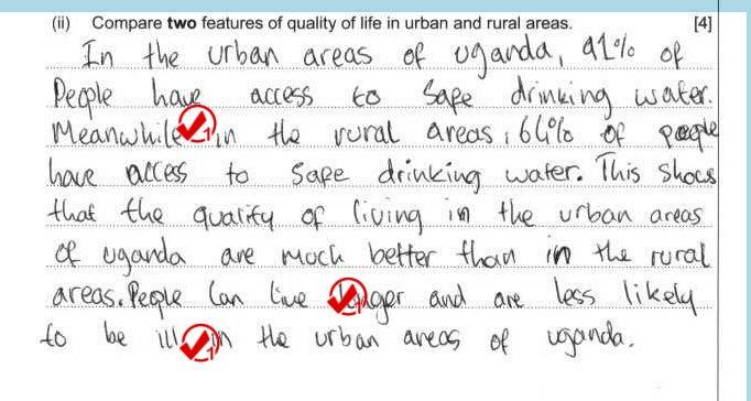
2 1. (c) 4 Study the information below which shows differences between urban and rural Uganda. Examiner only Uganda s literacy rate Uganda s infant mortality rate 120 percentage of population deaths per 1000 live births urban rural 0 urban rural Urban Rural Literacy Rate 87% 66% Infant mortality rate per 1000 live births Life expectancy (years) Access to safe drinking water 91% 64% (ii) Compare two features of quality of life in urban and rural areas. [4] WJEC CBAC Ltd. ( )
3

4
5
6


7 (d) 5 In many countries people are moving from rural areas to live in urban areas. Examiner only Rural Uganda Kampala, an urban area of Uganda (i) Explain why people might leave rural areas of Uganda to move to cities in Uganda. [5] Charlotte Thege/Alamy Zute Lightfoot/Alamy WJEC CBAC Ltd. ( ) Turn over.
8 6 1. d (ii) Suggest ways in which rural to urban migration may affect urban areas. [6] Examiner only WJEC CBAC Ltd. ( )
9 1 (d) (i) Explain why people might leave rural areas of Uganda to move to cities in Uganda. [5]

10 1 (d) (i) Explain why people might leave rural areas of Uganda to move to cities in Uganda. [5] L2 This response was given Level 2 = 3 marks L2
11 1 (d) (i) Explain why people might leave rural areas of Uganda to move to cities in Uganda. [5]
12 1 (d) (i) Explain why people might leave rural areas of Uganda to move to cities in Uganda. [5] L2 This response was given Level 1 = 2 marks.
13 1 (d) (ii) Suggest ways in which rural to urban migration my affect urban areas. [6]
14 1 (d) (ii) Suggest ways in which rural to urban migration my affect urban areas. [6] L2 L2 This response was given Level 2 = 4 marks
15 1 (d) (ii) Suggest ways in which rural to urban migration my affect urban areas. [6]

16 1 (d) (ii) Suggest ways in which rural to urban migration my affect urban areas. [6] This response was given Level 1 = 2 marks

17 11 2. (b) Relief rainfall influences the pattern of precipitation in New Zealand. Examiner only Complete the diagram below by adding annotation at points 1, 2 and 3 to explain the process of relief rainfall. [4] 2 3 Prevailing winds 1 Southern Alps Rain shadow X NW Tasman Sea Cross-section across South Island New Zealand Pacific Ocean Y SE WJEC CBAC Ltd. ( ) Turn over.
18 Question 2 (b) Relief rainfall influences the pattern of precipitation in New Zealand. Complete the diagram below by adding annotation at points 1, 2 and 3 to explain the process of relief rainfall. [4]

19 Question 2 (b) Relief rainfall influences the pattern of precipitation in New Zealand. Complete the diagram below by adding annotation at points 1, 2 and 3 to explain the process of relief rainfall. [4] This response was given Level 2 = 2 marks
20 Question 2 (b) Relief rainfall influences the pattern of precipitation in New Zealand. Complete the diagram below by adding annotation at points 1, 2 and 3 to explain the process of relief rainfall. [4]
21 Question 2 (b) Relief rainfall influences the pattern of precipitation in New Zealand. Complete the diagram below by adding annotation at points 1, 2 and 3 to explain the process of relief rainfall. [4] This response was given Level 1 = 1 mark

22 12 2. (c) Precipitation in New Zealand is also associated with the passage of depressions across the country. The weather map below shows a depression crossing New Zealand in August August is a winter month in New Zealand because it is in the Southern hemisphere. N km Key 870 Warm front Cold front Occluded front Isobar No cloud 50% cloud Full cloud Queenstown 2. 3 Christchurch Wind strength Weather., 5 knots 10 knots Rain Drizzle 870 L Snow Thunderstorm 5 Temperature is 5 C Poor weather brings chaos to some parts of New Zealand August 2011 It was reported that many important services were disrupted, for example: airports were closed; roads were blocked; electricity supplies were cut; telephone lines were down. WJEC CBAC Ltd. ( )
23 13 The area around Queenstown faced serious social and economic disruption as a result of the storm. Use information from the weather map and the newspaper article to explain why. [6] Examiner only WJEC CBAC Ltd. ( ) Turn over.
24 Question 2 (c) The area around Queenstown faced serious social and economic disruption as a result of the storm. Use information from the weather map and the newspaper article to explain why. [6]

25 Question 2 (c) The area around Queenstown faced serious social and economic disruption as a result of the storm. Use information from the weather map and the newspaper article to explain why. [6] L2 This response was given Level 2 = 3 marks
26

27 This response was given Level 1 = 2 marks
28 2. d 15 (ii) Drought sometimes affects other parts of the world. Suggest ways in which individuals and organisations can respond to drought. [6] Examiner only WJEC CBAC Ltd. ( ) Turn over.
29 (d) (ii) Drought sometimes affects other parts of the world. Suggest ways in which individuals and organisations can respond to drought. [6]
30 (d) (ii) Drought sometimes affects other parts of the world. Suggest ways in which individuals and organisations can respond to drought. [6] L2 This response was given Level 2 = 3 marks
31 (d) (ii) Drought sometimes affects other parts of the world. Suggest ways in which individuals and organisations can respond to drought. [6]

32 (d) (ii) Drought sometimes affects other parts of the world. Suggest ways in which individuals and organisations can respond to drought. [6] L2 L2 L2 This response was given Level 2 = 4
GCSE 4241/02 GEOGRAPHY (Specification B) HIGHER TIER UNIT 1
 HIGHER TIER UNIT 1") Surname Centre Number Candidate Number Other Names 0 GCSE 4241/02 GEOGRAPHY (Specification B) HIGHER TIER UNIT 1 P.M. TUESDAY, 13 May 2014 1 hour For s use Question Maximum Mark Mark Awarded 1. 30 SPaG
Surname Centre Number Candidate Number Other Names 0 GCSE 4241/02 GEOGRAPHY (Specification B) HIGHER TIER UNIT 1 P.M. TUESDAY, 13 May 2014 1 hour For s use Question Maximum Mark Mark Awarded 1. 30 SPaG
GCSE 4241/01 GEOGRAPHY (Specification B) FOUNDATION TIER UNIT 1
 FOUNDATION TIER UNIT 1") Surname Centre Number Candidate Number Other Names 0 GCSE 4241/01 GEOGRAPHY (Specification B) FOUNDATION TIER UNIT 1 P.M. TUESDAY, 13 May 2014 1 hour For s use Question Maximum Mark Mark Awarded 1. 30
Surname Centre Number Candidate Number Other Names 0 GCSE 4241/01 GEOGRAPHY (Specification B) FOUNDATION TIER UNIT 1 P.M. TUESDAY, 13 May 2014 1 hour For s use Question Maximum Mark Mark Awarded 1. 30
CHANGING PHYSICAL AND HUMAN LANDSCAPES SAMPLE ASSESSMENT MATERIALS
 GCSE GEOGRAPHY A Sample Assessment Materials 5 GCSE GEOGRAPHY A COMPONENT 1 CHANGING PHYSICAL AND HUMAN LANDSCAPES SAMPLE ASSESSMENT MATERIALS 1 hour 30 minutes Section Question Mark SPaG A B 1 2 Either
ENVIRONMENTAL AND DEVELOPMENT ISSUES SAMPLE ASSESSMENT MATERIALS
 GCSE GEOGRAPHY Sample Assessment Materials 41 GCSE GEOGRAPHY UNIT 2 ENVIRONMENTAL AND DEVELOPMENT ISSUES SAMPLE ASSESSMENT MATERIALS 1 hour 30 minutes Section Question Mark SPaG A B 1 2 either 3 or 4 28
1 Study the map of Cornwall below. Answer the question that follows.
 Distance and direction 1 Study the map of Cornwall below. Answer the question that follows. five statements that are correct. Lanreath is about 22 km from Plymouth Lanreath is about 28 km from Plymouth
Ch. 3: Weather Patterns
 Ch. 3: Weather Patterns Sect. 1: Air Mass & Fronts Sect. 2: Storms Sect. 3: Predicting the Weather Sect. 4: Weather forecasters use advanced technologies Ch. 3 Weather Fronts and Storms Objective(s) 7.E.1.3
Weather Unit Part 2: Meteorology
 Name: Earth Science Date: Period: Weather Unit Part 2: Meteorology 1 The map below shows North America and its surrounding bodies of water. Country borders are shown. On the map, label the following locations:
Weather: Air Patterns
 Weather: Air Patterns Weather: Air Patterns Weather results from global patterns in the atmosphere interacting with local conditions. You have probably experienced seasonal shifts, such as winter in New
Untitled.notebook May 12, Thunderstorms. Moisture is needed to form clouds and precipitation the lifting of air, or uplift, must be very strong
 Thunderstorms Moisture is needed to form clouds and precipitation the lifting of air, or uplift, must be very strong cold air and warm air must mix; creating an active circulation system that has both
Gozo College Boys Secondary Victoria Gozo, Malta Ninu Cremona
 Gozo College Boys Secondary Victoria Gozo, Malta Ninu Cremona Half Yearly Examination 2011 2012 Form 4 Track 3 GEOGRAPHY (Option) Time: 1½ Hours Name: Class: Answer all questions in the space provided.
Unit: Weather Study Guide
 Name: Period: Unit: Weather Study Guide Define each vocabulary word on a separate piece of paper or index card. Weather Climate Temperature Wind chill Heat index Sky conditions UV index Visibility Wind
GRAAD 12 NATIONAL SENIOR CERTIFICATE GRADE 12
 GRAAD 12 NATIONAL SENIOR CERTIFICATE GRADE 12 GEOGRAPHY P1 FEBRUARY/MARCH 2013 MARKS: 300 TIME: 3 hours This question paper consists of 11 pages and a 12-page annexure. Geography/P1 2 DBE/Feb. Mar. 2013
What Is the Weather Like in Different Regions of the United States?
 Learning Set 1 What Is Weather, and How Is It Measured and Described? 1.3 Explore What Is the Weather Like in Different Regions of the United States? trends: patterns or tendencies you can see over a broad
Candidate Name Centre Number Candidate Number CHANGING PHYSICAL AND HUMAN LANDSCAPES SAMPLE ASSESSMENT MATERIALS
 GCSE GEOGRAPHY Sample Assessment Materials 5 Candidate Name Centre Number Candidate Number 0 GCSE GEOGRAPHY UNIT 1 CHANGING PHYSICAL AND HUMAN LANDSCAPES SAMPLE ASSESSMENT MATERIALS 1 hour 30 minutes Section
You have learned that meteorologists collect data about the earth s
 69 Forecasting eather I N V E S T I G AT I O N You have learned that meteorologists collect data about the earth s weather. They often use that data to construct weather maps. Meteorologists then use those
Go With the Flow From High to Low Investigating Isobars
 Go With the Flow From High to Low Investigating Isobars Science 10 Mrs. Purba Air Masses The air over a warm surface can be heated, causing it to rise above more dense air. The result is the formation
Unit 5 Lesson 3 How is Weather Predicted? Copyright Houghton Mifflin Harcourt Publishing Company
 Tracking the Weather Warm up 1 Why is it important to watch the weather forecast before traveling to another country? Tracking the Weather A meteorologist is a scientist who studies weather. Meteorologists
AS Population Change Question spotting
 AS Change Question spotting Changing rate of growth How the rate of growth has changed over the last 100 years Explain the reasons for these changes Describe global or national distribution. Study the
Weather. Chapter Test A. Multiple Choice. Write the letter of the correct answer on the line at the left.
 Weather Chapter Test A Multiple Choice Write the letter of the correct answer on the line at the left. 1. The most dangerous aspect of a snowstorm is often the a. high winds. b. depth of snow. c. brightness.
Fig Major air masses of the world
 Fig. 9.3 Major air masses of the world CLASSIFICATION FOUR BASIC CATEGORIES OF AIR MASSES: POLAR - P ARCTIC - A TROPICAL - T EQUATORIAL - E TWO DESIGNATIONS OF SURFACE IN SOURCE REGION MARITIME - m. CONTINENTAL
GIRLS SECON DARY - MRIEĦEL HALF-YEARLY EXAMINATIONS 2016/2017
 GIRLS SECON DARY - MRIEĦEL HALF-YEARLY EXAMINATIONS 2016/2017 FORM: 4 Time: 1 ½ hrs Name: Class: Section A: Weather and Climate 1. Place the following weather conditions under the appropriate heading.
UNIVERSITY OF CAMBRIDGE INTERNATIONAL EXAMINATIONS General Certifi cate of Education Advanced Subsidiary Level and Advanced Level
 UNIVERSITY OF CAMBRIDGE INTERNATIONAL EXAMINATIONS General Certifi cate of Education Advanced Subsidiary Level and Advanced Level *3321951161* GEOGRAPHY 9696/01 Paper 1 Core Geography May/June 2008 Additional
Global Atmospheric Circulation. Past climate change and natural causes. Global climate change and human activity
 GCSE Geography Edexcel B Revision Checklist Paper 1. Global Geographical Issues Topic 1. Hazardous Earth Key Idea I know/ understand The world s climate system Global Atmospheric Circulation Past climate
NATIONAL SENIOR CERTIFICATE GRADE 12
 NATIONAL SENIOR CERTIFICATE GRADE 12 GEOGRAPHY P1 FEBRUARY/MARCH 2015 MARKS: 225 TIME: 3 hours This question paper consists of 12 pages and an annexure of 12 pages. *GEOGE1* Geography/P1 2 INSTRUCTIONS
National Meteorological Library and Archive
 National Meteorological Library and Archive Fact sheet No. 4 Climate of the United Kingdom Causes of the weather in the United Kingdom The United Kingdom lies in the latitude of predominately westerly
Weather FActors. May 8 4:15 PM. Analyzing AIR MASSES & THEIR MOVEMENT
 ` Weather FActors P: Analyze weather Q: What are the factors that cause weather? May 8 4:15 PM Analyzing AIR MASSES & THEIR MOVEMENT Read and take notes... Using pages 72-79: (IN YOUR JOURNAL!) - Identify
Mr. P s Science Test!
 WEATHER- 2017 Mr. P s Science Test! # Name Date 1. Draw and label a weather station model. (10 pts) 2. The is the layer of the atmosphere with our weather. 3. Meteorologists classify clouds in about different
Percentage of normal rainfall for August 2017 Departure from average air temperature for August 2017
 New Zealand Climate Update No 219, August 2017 Current climate August 2017 Overall, mean sea level pressure was lower than normal over and to the west of New Zealand during August while higher than normal
SIO15 Midterm 2, Wednesday Nov. 28, 2018
 SIO15 Midterm 2, Wednesday Nov. 28, 2018 TEST VARIATION: B 1) For what are flood frequency curves used? a) to predict the next rain storm b) to estimate the highest flood likely in a 100-year interval
NATIONAL SPORT SCHOOL
 NATIONAL SPORT SCHOOL Mark HALF-YEARLY EXAMINATION 2016 Level 7-8 FORM 3 Geography Option TIME: 1h 30min Question 1 2 3 4 5 6 7 8 9 10 11 12 Max. Mark Global Mark Mark DO NOT WRITE ABOVE THIS LINE Name:
NCM COMPUTER & BUSINESS ACADEMY ASSIGNMENT TERM
 NCM COMPUTER & BUSINESS ACADEMY SUBJECT: GEOGRAPHY GRADE 12 ASSIGNMENT TERM 1-2016 TOTAL: 150 MARKS LECTURER: ANSWER ALL QUESTIONS CLIMATE, WEATHER AND GEOMORPHOLOGY Answer at least ONE question in this
National Meteorological Library and Archive
 National Meteorological Library and Archive Fact sheet No. 4 Climate of the United Kingdom Causes of the weather in the United Kingdom The United Kingdom lies in the latitude of predominately westerly
Chapter 12: Meteorology
 Chapter 12: Meteorology Section 1: The Causes of Weather 1. Compare and contrast weather and climate. 2. Analyze how imbalances in the heating of Earth s surface create weather. 3. Describe how and where
Activity 69, Forecasting Weather! Issues & Earth Science: Student Book!!
 Activity 69, Forecasting eather! from! Issues & Earth Science: Student Book!!! 2012 The Regents of the University of California! 69 Forecasting eather I N V E S T I O N I G AT You have learned that meteorologists
Fronts. Direction of Front
 Fronts Direction of Front Direction of Front Warm Front A cold air mass meets and displaces a warm air mass. Because the moving cold air is more dense, it moves under the less-dense warm air, pushing it
Atmosphere and Weather Revision Notes
 Atmosphere and Weather Revision Notes Atmosphere The blanket of gases that surrounds the Earth is called the atmosphere. The main gases are nitrogen (78 %), oxygen (21 %), water vapour, ozone and carbon
Satellite Data Utilisation at the National Meteorological Service of New Zealand (MetService) Wim van Dijk November 2015 AOMSUC6 SC 2-4
 Wim van Dijk November 2015 AOMSUC6 SC 2-4") Satellite Data Utilisation at the National Meteorological Service of New Zealand (MetService) Wim van Dijk November 2015 AOMSUC6 SC 2-4 Forecasting at MetService MetService currently employs ~275 staff
Satellite Data Utilisation at the National Meteorological Service of New Zealand (MetService) Wim van Dijk November 2015 AOMSUC6 SC 2-4 Forecasting at MetService MetService currently employs ~275 staff
NEW ZEALAND WEATHER. BRIEF REVIEW OF THE WEATHER WINTER 1991 (Fig. 1) CONTRASTING RAINFALL, COLD IN THE SOUTH-WEST OF THE SOUTH ISLAND
 CONTRASTING RAINFALL, COLD IN THE SOUTH-WEST OF THE SOUTH ISLAND") Weather and Climate (1992) 12: 47-52 47 NEW ZEALAND WEATHER BRIEF REVIEW OF THE WEATHER (Fig. 1) CONTRASTING RAINFALL, COLD IN THE SOUTH-WEST OF THE SOUTH ISLAND An El Nino event (negative phase of the
Weather and Climate (1992) 12: 47-52 47 NEW ZEALAND WEATHER BRIEF REVIEW OF THE WEATHER (Fig. 1) CONTRASTING RAINFALL, COLD IN THE SOUTH-WEST OF THE SOUTH ISLAND An El Nino event (negative phase of the
Name: Regents Earth Science. Weather and Climate - Review Questions
 Name: Regents Earth Science Weather and Climate - Review Questions Date: Thayer - 279 1. People sometimes release substances into the atmosphere to increase the probability of rain by A) raising the air
November 28, 2017 Day 1
 November 28, 2017 Day 1 Air Masses & Fronts Teachers- please out the sheet (right) for the students to fill in as we go! Review: Clouds & Precipitation? What are the 4 different clouds? Status, Cumulus,
Level 1 Geography, 2015
 91008 910080 1SUPERVISOR S Level 1 Geography, 2015 91008 Demonstrate geographic understanding of population concepts 9.30 a.m. Thursday 12 November 2015 Credits: Four Achievement Achievement with Merit
National 5 Geography. Practice Exam Papers
 National 5 Geography Practice Exam Papers December 2017 SPECIMEN QUESTION PAPER 1 SECTION 1: PHYSICAL ENVIRONMENTS Question 1 (a) Study the Ordnance Survey map extract (Item A) of the Pembroke Map area.
Chapter 1 Study Guide
 Chapter 1 Study Guide Reminders: Vocabulary quiz and test will be on Tuesday, September 6th. Complete study guide and bring completed to school Friday, September 2nd. You are NOT required to print the
SIO15 Midterm 2, Friday Dec. 1, 2017 TEST VARIATION: 2
 SIO15 Midterm 2, Friday Dec. 1, 2017 TEST VARIATION: 2 1) Why does San Diego have flood control channels? a) many hurricanes make landfall and bring devastating floods b) strong winter storms can bring
SCI-4 Mil-Brock-Weather Exam not valid for Paper Pencil Test Sessions
 SCI-4 Mil-Brock-Weather Exam not valid for Paper Pencil Test Sessions [Exam ID:1TLR5H 1 Warm air rises and cools. Moisture in the air forms clouds that will bring rain. What pressure system is described?
b. The boundary between two different air masses is called a.
 NAME Earth Science Weather WebQuest Part 1. Air Masses 1. Find out what an air mass is. http://okfirst.mesonet.org/train/meteorology/airmasses.html a. What is an air mass? An air mass is b. The boundary
Guided Reading Chapter 18: Weather Patterns
 Name Number Date Guided Reading Chapter 18: Weather Patterns 18-1: Air Masses and Fronts 1. What is an air mass? 2. Scientists classify air masses according to and 3. Is the following sentence true or
2. What are the four most common gasses in the atmosphere and their percentages?
 Meteorology Review Directions: Answer the following open ended review questions. Utilize a diagram where appropriate and do make sure that you label and describe the drawing. Atmospheric Composition 1.
JUNIOR SECONDARY EXTERNAL EXAMINATION
 Candidate name JUNIOR SECONDARY EXTERNAL EXAMINATION Grade 9 Geography Specimen Paper 1 Duration 2 hours Marks 90 2018 INSTRUCTIONS AND INFORMATION TO CANDIDATES Write your name in space provided Answer
Cambridge International Examinations Cambridge International Advanced Subsidiary and Advanced Level
 Cambridge International Examinations Cambridge International Advanced Subsidiary and Advanced Level *9303531352* GEOGRAPHY 9696/11 Paper 1 Core Geography May/June 2014 No Additional Materials are required.
Forecasting Weather: Air Masses and Fronts
 Forecasting Weather: Air Masses and Fronts Weather is a combination of local conditions at any one time. It's what's happening outside right now, right here. Weather includes: Temperature Humidity Air
NEW ZEALAND WEATHER. BRIEF REVIEW OF WINTER AND SPRING 1990 WINTER 1990 (Fig. 1) Weather and Climate (1991) 11: 31-36
 Weather and Climate (1991) 11: 31-36") Weather and Climate (1991) 11: 31-36 31 NEW ZEALAND WEATHER BRIEF REVIEW OF WINTER AND SPRING 1990 WINTER 1990 (Fig. 1) Winter 1990 was very dry in the far south. Northeasterlies brought sunny conditions
Weather and Climate (1991) 11: 31-36 31 NEW ZEALAND WEATHER BRIEF REVIEW OF WINTER AND SPRING 1990 WINTER 1990 (Fig. 1) Winter 1990 was very dry in the far south. Northeasterlies brought sunny conditions
Climates of Earth. Lesson Outline LESSON 1. A. What is climate? 1. is the long-term average weather conditions that occur in a particular region.
 Lesson Outline LESSON 1 A. What is climate? 1. is the long-term average weather conditions that occur in a particular region. 2. Climate depends on how average weather conditions throughout the year. B.
(April 7, 2010, Wednesday) Tropical Storms & Hurricanes Part 2
 Tropical Storms & Hurricanes Part 2") Lecture #17 (April 7, 2010, Wednesday) Tropical Storms & Hurricanes Part 2 Hurricane Katrina August 2005 All tropical cyclone tracks (1945-2006). Hurricane Formation While moving westward, tropical disturbances
Lecture #17 (April 7, 2010, Wednesday) Tropical Storms & Hurricanes Part 2 Hurricane Katrina August 2005 All tropical cyclone tracks (1945-2006). Hurricane Formation While moving westward, tropical disturbances
3 Weather and Climate
 CHAPTER 22 3 Weather and Climate SECTION The Atmosphere KEY IDEAS As you read this section, keep these questions in mind: What are fronts? What are some types of severe weather? How is climate different
DEPARTMENT OF EARTH & CLIMATE SCIENCES Name SAN FRANCISCO STATE UNIVERSITY Nov 29, ERTH 360 Test #2 200 pts
 DEPARTMENT OF EARTH & CLIMATE SCIENCES Name SAN FRANCISCO STATE UNIVERSITY Nov 29, 2018 ERTH 360 Test #2 200 pts Each question is worth 4 points. Indicate your BEST CHOICE for each question on the Scantron
MASTERY ASSIGNMENT 2015
 Climate & Meteorology MASTERY ASSIGNMENT 2015 Directions: You must submit this document via Google Docs to lzimmerman@wcpss.net. The document must include the questions and pictures must be hand drawn
Queensland Floods- Part A
 Queensland Floods- Part A Floods Flooding is when the water level in a creek, river, lake or the sea rises and covers land that is normally dry. The rise in water can be due to numerous causes, although
Science 1206 Weather Unit REVIEW Short Answer
 Science 1206 Weather Unit REVIEW Short Answer 1. Which is defined as the short-term conditions of the atmosphere? 2. Which is defined as the long-term conditions of the atmosphere? 3. Which is used to
HAZARD DESCRIPTION... 1 LOCATION... 1 EXTENT... 1 HISTORICAL OCCURRENCES...
 WINTER STORM HAZARD DESCRIPTION... 1 LOCATION... 1 EXTENT... 1 HISTORICAL OCCURRENCES... 3 SIGNIFICANT PAST EVENTS... 4 PROBABILITY OF FUTURE EVENTS... 5 VULNERABILITY AND IMPACT... 5 Hazard Description
RR#4 - Multiple Choice
 1. The map below shows the amount of snowfall, in inches, produced by a lake-effect snowstorm in central New York State. The wind that produced this snowfall pattern most likely came from the 1) northeast
About places and/or important events Landmarks Maps How the land is, hills or flat or mountain range Connected to maps World Different countries
 What do you think you know about geography? About places and/or important events Landmarks Maps How the land is, hills or flat or mountain range Connected to maps World Different countries What do you
Class Notes: Weather
 Name: Date: Period: Weather The Physical Setting: Earth Science I. Cyclonic Weather Hurricane - Hurricane Statistics Largest of all the storms Approximately per year Nearly deaths per year Saffir-Simpson
Investigation 11.3 Weather Maps
 Name: Date: Investigation 11.3 Weather Maps What can you identify weather patterns based on information read on a weather map? There have been some amazing technological advancements in the gathering and
Station A. 1. In the Northern Hemisphere, the general direction of the flow of the jet stream is toward the: a. north b. east c.
 Station A 1. In the Northern Hemisphere, the general direction of the flow of the jet stream is toward the: a. north b. east c. south 2. The percentage of oxygen in the atmosphere is: a. 78% b. 99% c.
Guided Notes Weather. Part 2: Meteorology Air Masses Fronts Weather Maps Storms Storm Preparation
 Guided Notes Weather Part 2: Meteorology Air Masses Fronts Weather Maps Storms Storm Preparation The map below shows North America and its surrounding bodies of water. Country borders are shown. On the
Weather Elements (air masses, fronts & storms)
") Weather Elements (air masses, fronts & storms) S6E4. Obtain, evaluate and communicate information about how the sun, land, and water affect climate and weather. A. Analyze and interpret data to compare
Weather Elements (air masses, fronts & storms) S6E4. Obtain, evaluate and communicate information about how the sun, land, and water affect climate and weather. A. Analyze and interpret data to compare
The hydrologic service area (HSA) for this office covers Central Kentucky and South Central Indiana.
 for this office covers Central Kentucky and South Central Indiana.") January 2012 February 13, 2012 An X inside this box indicates that no flooding occurred within this hydrologic service area. January 2012 continued the string of wet months this winter. Rainfall was generally
January 2012 February 13, 2012 An X inside this box indicates that no flooding occurred within this hydrologic service area. January 2012 continued the string of wet months this winter. Rainfall was generally
PREDICTING THE WEATHER
 NAME DATE PARTNER(S) PREDICTING THE WEATHER How well does your local weatherman do in predicting the weather? Is he or she more accurate for the next day or for a week in the future? Why do you think that
Meteorology. I. The Atmosphere - the thin envelope of gas that surrounds the earth.
 Meteorology I. The Atmosphere - the thin envelope of gas that surrounds the earth. A. Atmospheric Structure - the atmosphere is divided into five distinct layers that are based on their unique characteristics.
Guided Notes Weather. Part 1: Weather Factors Temperature Humidity Air Pressure Winds Station Models
 Guided Notes Weather Part 1: Weather Factors Temperature Humidity Air Pressure Winds Station Models. 1. What is weather? Weather: short-term atmospheric conditions in a specific area at a specific time
Unit 4 Review Guide: Weather
 Unit 4 Review Guide: Weather Weather: The condition of the atmosphere at a specific time and place. Freezing: To become hardened into ice or into a solid body Deposition: The change in state of matter
Pd: Date: Page # Weather Patterns -- Lesson 2 Study Guide
 Name: Pd: Date: Page # Weather Patterns -- Lesson 2 Study Guide Rating Before Learning Goals Rating After 1 2 3 4 What are two types of pressure systems? 1 2 3 4 1 2 3 4 What drives weather patterns? 1
Enquiry question: How does the world s climate system function, why does it change and how can this be hazardous for people?
 Content Topic 1: Hazardous Earth Enquiry question: How does the world s climate system function, why does it change and how can this be hazardous for people? 1.1 The atmosphere operates as a global system
Climate.tgt, Version: 1 1
 Name: Key Concepts Choose the letter of the best answer. (5 points each) 1. 2. 3. 4. 5. 6. 7. 8. 9. 10. Date: A city located in the middle of North America experiences extreme temperature changes during
IWT Scenario 1 Integrated Warning Team Workshop National Weather Service Albany, NY October 31, 2014
 Integrated Warning Team Workshop National Weather Service Albany, NY October 31, 2014 23 24 25 26 27 Scenario 1 Timeline November 23-27 Sun Mon Tue Wed Thu Thanksgiving Day Sunday, Nov. 23 @ 430 pm NWS
What a Hurricane Needs to Develop
 Weather Weather is the current atmospheric conditions, such as air temperature, wind speed, wind direction, cloud cover, precipitation, relative humidity, air pressure, etc. 8.10B: global patterns of atmospheric
Ocean in Motion 7: El Nino and Hurricanes!
 Ocean in Motion 7: El Nino and Hurricanes! A. Overview 1. Ocean in Motion -- El Nino and hurricanes We will look at the ocean-atmosphere interactions that cause El Nino and hurricanes. Using vocabulary
New Hampshire State Climate Office Dr. Mary D. Stampone, State Climatologist
 New Hampshire State Climate Office Dr. Mary D. Stampone, State Climatologist University of New Hampshire c/o Department of Geography 73 Main Street Durham, NH 03824 Phone: 603-862-3136 Fax: 603-862-4362
WATER IN THE ATMOSPHERE
 WATER IN THE ATMOSPHERE I. Humidity A. Defined as water vapor or moisture in the air (from evaporation and condensation). B. The atmosphere gains moisture from the evaporation of water from oceans, lakes,
Use the terms from the following list to complete the sentences below. Each term may be used only once.
 Skills Worksheet Directed Reading Section: Air Masses Use the terms from the following list to complete the sentences below. Each term may be used only once. high pressure poles low pressure equator wind
air masses and Fronts 2013.notebook January 29, 2013
 1/4/12 Notes 1 Weather Data Log.docx 2 Air Masses Uniform bodies of air An air mass is a large body of air that has similar temperature and moisture throughout. How to name an air mass: first write the
iv vi x Using maps 2 Using images and analysing data 6 Using new technologies in geography 8
 Contents Exam board specification map Introduction Topic checker iv vi x Geographical skills Using maps 2 Using images and analysing data 6 Using new technologies in geography 8 Natural hazards Tectonic
M14/3/GEOGR/SP2/ENG/TZ0/XX/Q GEOGRAPHY STANDARD LEVEL PAPER 2. Monday 19 May 2014 (morning) 1 hour 20 minutes INSTRUCTIONS TO CANDIDATES
 1 hour 20 minutes INSTRUCTIONS TO CANDIDATES") M14/3/GEOGR/SP2/ENG/TZ0/XX/Q 22145203 GEOGRAPHY STANDARD LEVEL PAPER 2 Monday 19 May 2014 (morning) 1 hour 20 minutes INSTRUCTIONS TO CANDIDATES Do not open this examination paper until instructed to do
M14/3/GEOGR/SP2/ENG/TZ0/XX/Q 22145203 GEOGRAPHY STANDARD LEVEL PAPER 2 Monday 19 May 2014 (morning) 1 hour 20 minutes INSTRUCTIONS TO CANDIDATES Do not open this examination paper until instructed to do
Coimisiún na Scrúduithe Stáit State Examinations Commission. Junior Certificate Marking Scheme. Geography. Higher Level
 Coimisiún na Scrúduithe Stáit State Examinations Commission Junior Certificate 2013 Marking Scheme Geography Higher Level Note to teachers and students on the use of published marking schemes Marking schemes
UNIVERSITY OF CAMBRIDGE INTERNATIONAL EXAMINATIONS International General Certificate of Secondary Education
 UNIVERSITY OF CAMBRIDGE INTERNATIONAL EXAMINATIONS International General Certificate of Secondary Education *7683878348* GEOGRAPHY 0460/02 Paper 2 May/June 2008 Candidates answer on the Question Paper.
Percentage of normal rainfall for April 2018 Departure from average air temperature for April 2018
 New Zealand Climate Update No 227, May 2018 Current climate April 2018 Overall, April 2018 was characterised by lower pressure than normal over and to the southeast of New Zealand. Unlike the first three
Coimisiún na Scrúduithe Stáit State Examinations Commission JUNIOR CERTIFICATE 2010 MARKING SCHEME GEOGRAPHY HIGHER LEVEL
 Coimisiún na Scrúduithe Stáit State Examinations Commission JUNIOR CERTIFICATE 2010 MARKING SCHEME GEOGRAPHY HIGHER LEVEL 1 1. 3 @1mark each (i)true, (ii)true, (iii)false 2. 1 @ 3 marks Leaching 3. 1 @
Welcome to GCSE Geography. Where will it take us today?
 Welcome to GCSE Geography Where will it take us today? Topic 1.1: global hazards 1.1a: How can weather be hazardous? aiii) Weather extremes enquiry 16/09/2018 Think back.. WOTW Birmingham! City with 10
Grade 9 Geography Chapter 11 - Climate Connections
 Grade 9 Geography Chapter 11 - Climate Connections 1. Define: Weather. 2. In what way has weather affected your activities in the last two weeks? 3. Define: Climate. 4. Canada s climate is a function of
Global Weather Trade Winds etc.notebook February 17, 2017
 Global Weather 1 north pole northern hemisphere equator southern hemisphere south pole 2 We have seasons because of the Earth's tilt The seasons are opposite in the northern and southern hemispheres winter
Lab 19.2 Synoptic Weather Maps
 Lab 19.2 Synoptic Weather Maps Name: Partner: Purpose The purpose of this lab is to have you read and interpret the information displayed on synoptic weather maps. You will also learn the techniques used
CLIMATE. SECTION 14.1 Defining Climate
 Date Period Name CLIMATE SECTION.1 Defining Climate In your textbook, read about climate and different types of climate data. Put a check ( ) next to the types of data that describe climate. 1. annual
Paper Reference. Paper Reference(s) 1312/1F Edexcel GCSE Geography A Paper 1F Foundation Tier Monday 4 June 2007 Morning Time: 1 hour 45 minutes
 1312/1F Edexcel GCSE Geography A Paper 1F Foundation Tier Monday 4 June 2007 Morning Time: 1 hour 45 minutes") Centre No. Candidate No. Paper Reference 1 3 1 2 1 F Paper Reference(s) 1312/1F Edexcel GCSE Geography A Paper 1F Foundation Tier Monday 4 June 2007 Morning Time: 1 hour 45 minutes Materials required for
Centre No. Candidate No. Paper Reference 1 3 1 2 1 F Paper Reference(s) 1312/1F Edexcel GCSE Geography A Paper 1F Foundation Tier Monday 4 June 2007 Morning Time: 1 hour 45 minutes Materials required for
Winds and Global Circulation
 Winds and Global Circulation Atmospheric Pressure Winds Global Wind and Pressure Patterns Oceans and Ocean Currents El Nino How is Energy Transported to its escape zones? Both atmospheric and ocean transport
GCSE 4231/01 GEOGRAPHY (Specification A) FOUNDATION TIER UNIT 1: Core Geography
 FOUNDATION TIER UNIT 1: Core Geography") Surname Centre Number Candidate Number Other Names 0 GCSE 4231/01 GEOGRAPHY (Specification A) FOUNDATION TIER UNIT 1: Core Geography S16-4231-01 P.M. TUESDAY, 24 May 2016 1 hour 45 minutes For s use Question
Surname Centre Number Candidate Number Other Names 0 GCSE 4231/01 GEOGRAPHY (Specification A) FOUNDATION TIER UNIT 1: Core Geography S16-4231-01 P.M. TUESDAY, 24 May 2016 1 hour 45 minutes For s use Question
GC1DR Exam Review 2013
 GC1DR Exam Review 2013 Name: Your exam is just around the corner! By completing this review, you will be EXTREMELY well prepared to write this exam. Part A ON A SEPARATE PIECE OF PAPER, please complete
WEATHER FORECASTING Acquisition of Weather Information WFO Regions Weather Forecasting Tools Weather Forecasting Tools Weather Forecasting Methods
 1 2 3 4 5 6 7 8 WEATHER FORECASTING Chapter 13 Acquisition of Weather Information 10,000 land-based stations, hundreds of ships and buoys; four times a day, airports hourly Upper level: radiosonde, aircraft,
2) Find and copy a subtitle e.g. Does anything else influence weather? 10) Name two other things that influence climate and weather.
 Find and copy a subtitle e.g. Does anything else influence weather? 10) Name two other things that influence climate and weather.") Date Understand a report on climate zones 1) What is the title of the report? 2) Find and copy a subtitle eg Does anything else influence weather? 3) What is weather? 4) What is climate? 5) What is temperature?
Date Understand a report on climate zones 1) What is the title of the report? 2) Find and copy a subtitle eg Does anything else influence weather? 3) What is weather? 4) What is climate? 5) What is temperature?
Making weather connections. Student task A. Four connections. 1. Cut and arrange the cards below to make four sets of four connections:
 Student task A 1. Cut and arrange the cards below to make four sets of four connections: temperature Beaufort rain gauge barometer anticyclone snow C anemometer precipitation Six s depression gale pressure