Peter Bechtold. 1 European Centre for Medium Range Weather Forecast. COST Summer School Brac 2013: Global Convection
|
|
|
- Charla Logan
- 6 years ago
- Views:
Transcription

1 Global Numerical Weather prediction: the role of convection Peter Bechtold 1 European Centre for Medium Range Weather Forecast Slide 1

2 Content Global picture of convection and methods to analyse waves (Hoevmoeller, Eliassen-Palm fluxes, wavenumber-frequency diagrams) Balances and generation of potential energy and its conversion into kinetic energy Madden-Julian Oscillation Quasi-equilibrium closures for CAPE Diurnal cycle of convection Slide 2

,")


3 How to evaluate model (convection), how to trust the Analysis? Analysis increments SON UKMO Slide 3


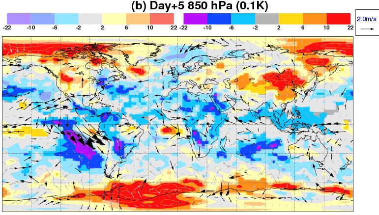
4 Day+5 Forecast errors: EPS ensemble mean vs. high-resolution Slide 4
5 Precipitation: SEEPS against other Centres 2010 & /2011 & 2011/12 Slide 5

6 Time-series: Precipitation Slide 6


7 Precipitation climatology mean=2.67 mm/day mean=2.85 mm/day Slide 7

8 Occurrence of deep and shallow convection Slide 8


9 JJA Precip and SWnet errors uncoupled Slide 9

10 Convective Tendencies: total & shallow Slide 10

11 Tropical T tendency budgets rad cloud Slide 11
12 The global Lorenz Energy cycle da dt Generation Conversion NQ NQ Lorenz efficiency factor Net heating R [1 ( 1 1)] T ( 1 1) q P Slide 12

 Steinheimer et al.")
13 Generation rates Total Generation rate (W/kg) Generation rates maximum in upper tropical troposphere Generation rate - radiation Grid-scale conversion rate Radiation does not contribute to the conversion rates but to the generation rate, but even there has only at poles a positive contribution (cooling at cold places) but globally a negative contribution (as in Tropics it is cooling where it is warm) Steinheimer et al. 2008, Tellus Slide 13


14 Conversion rates and convection Grid-scale conversion rate (W/kg) Subgrid conversion rate Grid-scale has positive and negative contributions to kinetic energy conversion rate, maximum in upper-tropical troposphere Subgrid conversion rate - convection Convection so important because contribution always positive! Slide 14
 Think of red/orange as warm regions in m=10 wave and dark shading")
15 Composite of the time-height sections of wavenumber 10 phase for q and Q. Glenn Shutts, 2006, Dyn. Atmos. Ocean 30 km At z~10 km, q and Q in phase time (hours) Think of red/orange as warm regions in m=10 wave and dark shading represents convective warming Slide 15
16 Shallow water system and linear waves V U U e e G z m 2 y /2 ik ( x ct ) 0 0 (, ) 1 2y 2 V V y y e G z m : Hn( y) 2 2 c 2 y /2 0 ( ) 4 1 (, ) k (2n 1), ; 0,1,2,... c 2 k c gh n Kelvin wave, geostrophic c k gh General, Hermite Polynomials Modes alternate asymm./symmetric Dispersion relation G z m e e z/(2 Hs ) imz (, ) Re( ) see T. Matsuno. Quasi-geostrophic motions in the equatorial area. J. Met. Soc. Japan, 44:25-42, Slide 16

")
17 Wave number Frequency Spectra OLR Cy38r1 (2012) NOAA Cy31r1 (ERAI) Slide 17

18 2D wave propagation with Eliassen-Palm fluxes Slide 18
19 General circulation and equilibrium in the Tropics Horizontal temperature fluctuations in the Tropics are small <1K/1000 km; and in the absence of precipitation the vertical motions(subsidence) tend to balance the cooling through IR radiation loss: w dθ/dz = dθ/dt_rad = -1-2 K/day => w ~ -.5 cm/s When precipitation takes place, heating rates are strong; e.g. 100 mm/day precip ~ energy flux of 2900 W/m2 or an average 30 K/day heating of the atmospheric column => w ~ 8.6 cm/s. However, this positive mean motion is composed of strong ascent of order w ~ 1 m/s in the Cumulus updrafts and slow descending motion around ( compensating subsidence ) Ro=NH/f with N the Brunt-Väisälä frequency and H the tropopause height, is the Rossby radius over which a perturbation spreads. In Tropics it is infinit as f->0, in the midlatitudes it is of O(1000 km). Therefore, daily weather forecasting is much more difficult in Tropics.. But contrary to middle-latitudes where predictability does not go beyond 14-days or so, Tropics have longterm predictability through intraseasonal variability (MJO) and SST coupling (ENSO) Slide 19

20 The MJO U850 U November 2011: Meteosat 7 + IFS Analysis Slide 20

21 YOTC: Hovmoeller of the OLR anomaly Slide 21
22 Progress in MJO prediction Slide 22
23 Correlations with T at 500 hpa for Phase 2/3 and forecast steps dt/dt_conv 60W 0 60E W 60 Precip 60W 0 60E W 60 For energy transformations in MJO see also Yanai, Chen, Tung (2000), and Matthews et a. (1999) Slide YOTC Asian Monsoon Symposium Beijing May

 Dynamics")


24 P (hpa) P (hpa) Difference in T-tendency: Convection over West Pacific - convection over Indian Ocean P (hpa) Dynamics (K/day) Conv (K/day) 50E W 50E W Cloud (K/day) Radiation (K/day) 50E W 50E W Slide 24

25 Correlations with T at 250 hpa for Phase 2/3 and forecast steps dt/dt_conv 60W 0 60E W 60 Precip 60W 0 60E W 60 Slide YOTC Asian Monsoon Symposium Beijing May

26 YOTC: OLR anomalies Slide 26


27 Effect of moisture sensitivity in convection scheme to MJO prediction q day+1 conv in 2007 day+5 dq/dt conv 2007-today day+1 day+5 see also Hirons et al. QJ RMS 2013 Slide 27

28 MJO initiation over Indian Ocean Take a long time series of filtered TRMM data and ERA-Interim reanalysis Identify MJO events, distinguish between primary, and successive, and separate from non-mjo convective events see also Ling et al. JAS 2013 to appear Slide 28

29 Anomalies in precipitation and 850 hpa wind Non-MJO day+3 day 0 day-3 day-6 day-9 day-12 day-15 Primary MJO significant easterly wind anomaly to the East Slide 29

30 day 0 day-6 day-12 day-18 day-24 P (hpa) Temperature anomalies Primary MJO Non-MJO significant cold anomaly in mid-troposph days ahead Slide 30

31 day 0 day-6 day-12 day-18 day-24 P (hpa) Specific humidity anomalies Primary MJO Non-MJO significant mid-tropospheric dry anomaly to the East Slide 31
32 Closure in Numerical Weather prediction Define (adiabatic) convective available potential energy and entraining density weighted CAPE=PCAPE compute its temporal derivative Slide 32
33 Closure in Numerical Weather prediction write prognostic equation formally as Define large-scale and convective contribution Slide 33
34 Closure in Numerical Weather prediction Need mass flux, can also estimate convective contribution from compensating subsidence term, M* first-guess mass flux (kg/m2 s) In diagnostic scheme formulate closure as or as quasi-equilibrium definition Slide 34

35 Closure Deep in Numerical Weather prediction Requires however specification of adjustment time-scale Diurnal cycle depending on cloud depth H, mean updraft velocity w and resolution n Slide 35
36 Closure Deep in Numerical Weather prediction Need to take into account the imbalance between deep convective motions and surface forcing, define: Adv+Rad+surf buoyancy flux Slide 36
37 Closure shallow in Numerical Weather prediction Define shallow as cloud depth<200 hpa, used twice as large entrainment as for deep. PCAPE integral singular for very shallow cloud, go back and use boundary-layer equilibrium only Use moist static energy h=cpt+gz+lq Could have also used q instead of h, or surface buoyance flux (as in previous slide) Slide 37

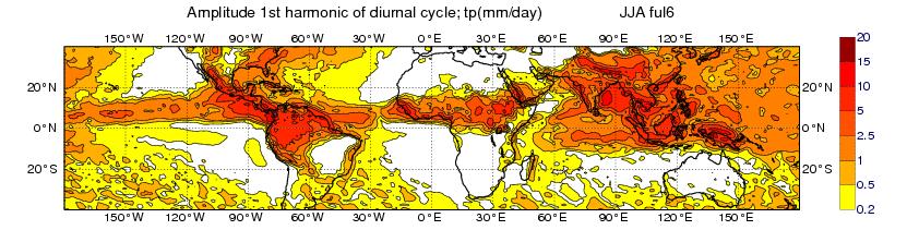
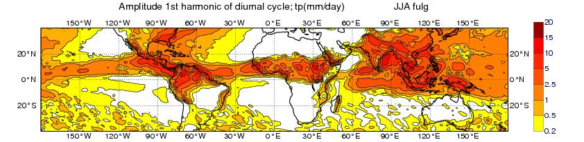
38 Diurnal cycle of Precipitation JJA: Amplitude (mm/d) TRMM CTL NEW Slide 38

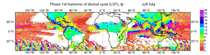
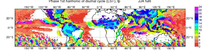
39 Diurnal cycle of Precipitation JJA: Phase (LST) TRMM CTL NEW Slide 39
40 Diurnal cycle: Surface Energy Budgets TP=total precipitation SW=shortwave radiation SF&LF=sensible&latent heat flux Note: (i) shift in TP between CTL and NEW, (ii) TP in CTL in phase with SF+LF=wrong! (iii) for Europe LF>SF, Africa SF>LF Slide 40
41 How does diurnal Precip scale? TP=total precipitation HF=surface enthalpy flux BF=surface buoyancy flux NOTE: in NEW = revised diurnal cycle surface daytime precipitation scales as the surface buoyancy flux Slide 41
42 Composite diurnal cycle: Model vs Obs Slide 42
43 Closure and diurnal cycle over Sahel June 2012 Slide 43

44 Diurnal evolution of total heating profile -radiation congestus Deep convection Turbulent heat flux Shallow convection Slide 44

45 Diurnal cycle Sahel June 2012: IFS & CRM Q1-Qrad -Q1 Slide 45

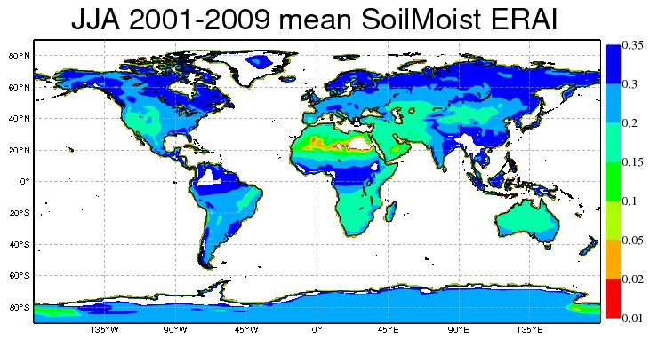
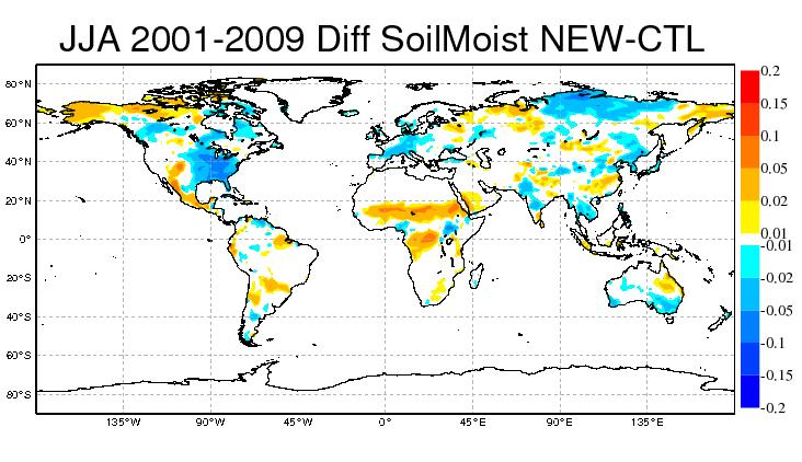
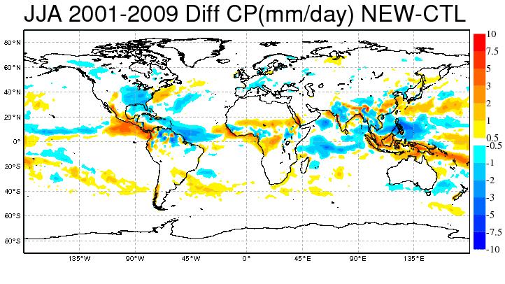
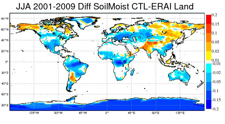
46 Diurnal cycle & change in circulation: analyse soil moisture change in seasonal forecasts Slide 46 46


47 West-African Monsoon during AMMA campaign Daily mean precipitation [mm/day] August 2006: day+1 forecast 12 o N OBS (FEWS RFEv2) Forecast Precip in model is shifted too far South, and too much precip over Ocean Slide 47 47

48 Diurnal cycle: Impact on weather forecasts Slide 48

49 Wintry showers: radar & forecasts Slide 49
50 Conclusions Global picture of convection and methods to analyse waves (Hoevmoeller, Eliassen-Palm fluxes, wavenumber-frequency diagrams) Madden-Julian Oscillation: Big improvement obtained through convection (sensitivity to moisture, charge/discharge cycle, energy conversion, propagation?) quasi-equilibrium closures for CAPE: several possibilities from scaling arguments, but practice tells which is/are optimal Diurnal cycle of convection: Large impact not only one phase of precip but also on circulation (notably African summer monsoon0 and weather forecast Slide 50
51 Towards higher resolution Scalability in Computing Scaling the Globe: the small planet testbed (not shown) Slide 51


52 IFS grid point space: EQ_REGIONS partitioning for 1024 MPI tasks Each MPI task has an equal number of grid points ICON DWD G. Modzynski G. Zängl Slide 52
53 IFS model: current and future model resolutions IFS model resolution Envisaged Operational Implementation Grid point spacing (km) Time-step (seconds) Estimated number of cores 1 T1279 H (L137) K T2047 H K T3999 NH K T7999 NH M 1 a gross estimate for the number of IBM Power7 equivalent cores needed to achieve a 10 day model forecast in under 1 hour (~240 FD/D), system size would normally be ~10 times this number. 2 Hydrostatic Dynamics 3 Non-Hydrostatic Dynamics Slide 53

54 Sustained Exaflop in 2033? Slide 54
55 Exascale problem projections To run a T7999 L137 forecast (~2.5km) may require approximately 1-4 million processors (of current technology) to run in one hour At the same time 1-4 Million processors could run a 50 member ensemble of T3999 L137 in the same hour But first we have to be able to run a T3999 L137 forecast efficiently in one hour! Slide 55
Convection: from the large-scale waves to the small-scale features
 Convection: from the large-scale waves to the small-scale features Peter Bechtold with thanks to L. Magnusson, S. Malardel, M. Herman (NMexico Tech), King-Fai Li (Caltech), F. Vâna, P. Lopez, F. Prates,
Winds of convection. Tropical wind workshop : Convective winds
 Winds of convection Peter Bechtold with special thanks to Martin Steinheimer, Michael Hermann&King-Fai Li and J. Bidlot, E. Holm, A. Beljaars, R Forbes, Ž. Fuchs, L. Isaksen, D. Kim, J.-E Kim, M. Leutbecher,
Introduction to tropical meteorology and deep convection
 Introduction to tropical meteorology and deep convection TMD Lecture 1 Roger K. Smith University of Munich A satpix tour of the tropics The zonal mean circulation (Hadley circulation), Inter- Tropical
Moist static energy budget diagnostics for. monsoon research. H. Annamalai
 Moist static energy budget diagnostics for monsoon research H. Annamalai JJAS Precipitation and SST Climatology I III II Multiple regional heat sources - EIO and SPCZ still experience high precipitation
Vertical Moist Thermodynamic Structure of the MJO in AIRS Observations: An Update and A Comparison to ECMWF Interim Reanalysis
 Vertical Moist Thermodynamic Structure of the MJO in AIRS Observations: An Update and A Comparison to ECMWF Interim Reanalysis Baijun Tian 1 Duane Waliser 1, Eric Fetzer 1, and Yuk Yung 2 1.Jet Propulsion
Introduction of products for Climate System Monitoring
 Introduction of products for Climate System Monitoring 1 Typical flow of making one month forecast Textbook P.66 Observed data Atmospheric and Oceanic conditions Analysis Numerical model Ensemble forecast
Introduction of climate monitoring and analysis products for one-month forecast
 Introduction of climate monitoring and analysis products for one-month forecast TCC Training Seminar on One-month Forecast on 13 November 2018 10:30 11:00 1 Typical flow of making one-month forecast Observed
Large-scale disturbances and convection. Željka Fuchs, University of Split
 Large-scale disturbances and convection Željka Fuchs, University of Split Huatulco airport Tropical disturbances Tropical cyclones Monsoons Easterly waves Madden-Julian oscillation Convectively
MJO modeling and Prediction
 MJO modeling and Prediction In-Sik Kang Seoul National University, Korea Madden & Julian Oscillation (MJO) index Composite: OLR & U850 RMM index based on Leading PCs of Combined EOF (OLR, U850, U200) P-1
Sub-grid parametrization in the ECMWF model
 Sub-grid parametrization in the ECMWF model Anton Beljaars Thanks to: Gianpaolo Balsamo, Peter Bechtold, Richard Forbes, Thomas Haiden, Marta Janiskova and Irina Sandu WWOSC: Parametrization at ECMWF Slide
Introduction to tropical meteorology and deep convection
 Introduction to tropical meteorology and deep convection Roger K. Smith University of Munich A satpix tour of the tropics The zonal mean circulation (Hadley circulation), Inter- Tropical Convergence Zone
Understanding the local and global impacts of model physics changes
 ECMWF Annual Seminar 2008 MJR 1 Understanding the local and global impacts of model physics changes Mark Rodwell Work with Thomas Jung 4 September 2008 Thanks to: MJR 2 Motivation The real world and GCMs
ENSO Cycle: Recent Evolution, Current Status and Predictions. Update prepared by Climate Prediction Center / NCEP 5 August 2013
 ENSO Cycle: Recent Evolution, Current Status and Predictions Update prepared by Climate Prediction Center / NCEP 5 August 2013 Outline Overview Recent Evolution and Current Conditions Oceanic Niño Index
ENSO Cycle: Recent Evolution, Current Status and Predictions. Update prepared by Climate Prediction Center / NCEP 11 November 2013
 ENSO Cycle: Recent Evolution, Current Status and Predictions Update prepared by Climate Prediction Center / NCEP 11 November 2013 Outline Overview Recent Evolution and Current Conditions Oceanic Niño Index
ENSO Cycle: Recent Evolution, Current Status and Predictions. Update prepared by Climate Prediction Center / NCEP 23 April 2012
 ENSO Cycle: Recent Evolution, Current Status and Predictions Update prepared by Climate Prediction Center / NCEP 23 April 2012 Outline Overview Recent Evolution and Current Conditions Oceanic Niño Index
ENSO Cycle: Recent Evolution, Current Status and Predictions. Update prepared by Climate Prediction Center / NCEP 25 February 2013
 ENSO Cycle: Recent Evolution, Current Status and Predictions Update prepared by Climate Prediction Center / NCEP 25 February 2013 Outline Overview Recent Evolution and Current Conditions Oceanic Niño Index
Key Physics of the Madden-Julian Oscillation Based on Multi-model Simulations
 Key Physics of the Madden-Julian Oscillation Based on Multi-model Simulations Xianan Jiang Joint Institute for Regional Earth System Sci. & Engineering / Univ. of California, Los Angeles Jet Propulsion
Boundary layer equilibrium [2005] over tropical oceans
![Boundary layer equilibrium [2005] over tropical oceans](/thumbs/96/128963638.jpg "Boundary layer equilibrium [2005] over tropical oceans") Boundary layer equilibrium [2005] over tropical oceans Alan K. Betts [akbetts@aol.com] Based on: Betts, A.K., 1997: Trade Cumulus: Observations and Modeling. Chapter 4 (pp 99-126) in The Physics and Parameterization
Boundary layer equilibrium [2005] over tropical oceans Alan K. Betts [akbetts@aol.com] Based on: Betts, A.K., 1997: Trade Cumulus: Observations and Modeling. Chapter 4 (pp 99-126) in The Physics and Parameterization
Seasonal Climate Outlook for South Asia (June to September) Issued in May 2014
 Issued in May 2014") Ministry of Earth Sciences Earth System Science Organization India Meteorological Department WMO Regional Climate Centre (Demonstration Phase) Pune, India Seasonal Climate Outlook for South Asia (June
Ministry of Earth Sciences Earth System Science Organization India Meteorological Department WMO Regional Climate Centre (Demonstration Phase) Pune, India Seasonal Climate Outlook for South Asia (June
ENSO Cycle: Recent Evolution, Current Status and Predictions. Update prepared by Climate Prediction Center / NCEP 15 July 2013
 ENSO Cycle: Recent Evolution, Current Status and Predictions Update prepared by Climate Prediction Center / NCEP 15 July 2013 Outline Overview Recent Evolution and Current Conditions Oceanic Niño Index
ENSO Cycle: Recent Evolution, Current Status and Predictions. Update prepared by Climate Prediction Center / NCEP July 26, 2004
 ENSO Cycle: Recent Evolution, Current Status and Predictions Update prepared by Climate Prediction Center / NCEP July 26, 2004 Outline Overview Recent Evolution and Current Conditions Oceanic NiZo Index
Convection Trigger: A key to improving GCM MJO simulation? CRM Contribution to DYNAMO and AMIE
 Convection Trigger: A key to improving GCM MJO simulation? CRM Contribution to DYNAMO and AMIE Xiaoqing Wu, Liping Deng and Sunwook Park Iowa State University 2009 DYNAMO Workshop Boulder, CO April 13-14,
ENSO Cycle: Recent Evolution, Current Status and Predictions. Update prepared by Climate Prediction Center / NCEP 24 September 2012
 ENSO Cycle: Recent Evolution, Current Status and Predictions Update prepared by Climate Prediction Center / NCEP 24 September 2012 Outline Overview Recent Evolution and Current Conditions Oceanic Niño
Model error and seasonal forecasting
 Model error and seasonal forecasting Antje Weisheimer European Centre for Medium-Range Weather Forecasts ECMWF, Reading, UK with thanks to Paco Doblas-Reyes and Tim Palmer Model error and model uncertainty
Operational and research activities at ECMWF now and in the future
 Operational and research activities at ECMWF now and in the future Sarah Keeley Education Officer Erland Källén Director of Research ECMWF An independent intergovernmental organisation established in 1975
The Madden Julian Oscillation in the ECMWF monthly forecasting system
 The Madden Julian Oscillation in the ECMWF monthly forecasting system Frédéric Vitart ECMWF, Shinfield Park, Reading RG2 9AX, United Kingdom F.Vitart@ecmwf.int ABSTRACT A monthly forecasting system has
What is the Madden-Julian Oscillation (MJO)?
?") What is the Madden-Julian Oscillation (MJO)? Planetary scale, 30 90 day oscillation in zonal wind, precipitation, surface pressure, humidity, etc., that propagates slowly eastward Wavelength = 12,000 20,000
What is the Madden-Julian Oscillation (MJO)? Planetary scale, 30 90 day oscillation in zonal wind, precipitation, surface pressure, humidity, etc., that propagates slowly eastward Wavelength = 12,000 20,000
Large-Eddy Simulations of Tropical Convective Systems, the Boundary Layer, and Upper Ocean Coupling
 DISTRIBUTION STATEMENT A. Approved for public release; distribution is unlimited. Large-Eddy Simulations of Tropical Convective Systems, the Boundary Layer, and Upper Ocean Coupling Eric D. Skyllingstad
An Introduction to Coupled Models of the Atmosphere Ocean System
 An Introduction to Coupled Models of the Atmosphere Ocean System Jonathon S. Wright jswright@tsinghua.edu.cn Atmosphere Ocean Coupling 1. Important to climate on a wide range of time scales Diurnal to
Introduction of Seasonal Forecast Guidance. TCC Training Seminar on Seasonal Prediction Products November 2013
 Introduction of Seasonal Forecast Guidance TCC Training Seminar on Seasonal Prediction Products 11-15 November 2013 1 Outline 1. Introduction 2. Regression method Single/Multi regression model Selection
Why do GCMs have trouble with the MJO?
 Why do GCMs have trouble with the MJO? The Madden-Julian Oscillation West East 200 [hpa] 500 Cool & dry Cool & dry p 700 850 SST Lag Day +20 +15 +10 +5 0-5 -10-15 -20 ~20 days ~10 days ~10-15 days
The Australian Summer Monsoon
 The Australian Summer Monsoon Aurel Moise, Josephine Brown, Huqiang Zhang, Matt Wheeler and Rob Colman Australian Bureau of Meteorology Presentation to WMO IWM-IV, Singapore, November 2017 Outline Australian
WaVaCS summerschool Autumn 2009 Cargese, Corsica
 Introduction Part I WaVaCS summerschool Autumn 2009 Cargese, Corsica Holger Tost Max Planck Institute for Chemistry, Mainz, Germany Introduction Overview What is a parameterisation and why using it? Fundamentals
Probabilistic predictions of monsoon rainfall with the ECMWF Monthly and Seasonal Forecast Systems
 Probabilistic predictions of monsoon rainfall with the ECMWF Monthly and Seasonal Forecast Systems Franco Molteni, Frederic Vitart, Tim Stockdale, Laura Ferranti, Magdalena Balmaseda European Centre for
CHAPTER 8 NUMERICAL SIMULATIONS OF THE ITCZ OVER THE INDIAN OCEAN AND INDONESIA DURING A NORMAL YEAR AND DURING AN ENSO YEAR
 CHAPTER 8 NUMERICAL SIMULATIONS OF THE ITCZ OVER THE INDIAN OCEAN AND INDONESIA DURING A NORMAL YEAR AND DURING AN ENSO YEAR In this chapter, comparisons between the model-produced and analyzed streamlines,
ECMWF Forecasting System Research and Development
 ECMWF Forecasting System Research and Development Jean-Noël Thépaut ECMWF October 2012 Slide 1 and many colleagues from the Research Department Slide 1, ECMWF The ECMWF Integrated Forecasting System (IFS)
Impact of Resolution on Extended-Range Multi-Scale Simulations
 DISTRIBUTION STATEMENT A. Approved for public release; distribution is unlimited. Impact of Resolution on Extended-Range Multi-Scale Simulations Carolyn A. Reynolds Naval Research Laboratory Monterey,
ENSO: Recent Evolution, Current Status and Predictions. Update prepared by: Climate Prediction Center / NCEP 9 November 2015
 ENSO: Recent Evolution, Current Status and Predictions Update prepared by: Climate Prediction Center / NCEP 9 November 2015 Outline Summary Recent Evolution and Current Conditions Oceanic Niño Index (ONI)
SPECIAL PROJECT PROGRESS REPORT
 SPECIAL PROJECT PROGRESS REPORT Progress Reports should be 2 to 10 pages in length, depending on importance of the project. All the following mandatory information needs to be provided. Reporting year
Gravity Waves. Lecture 5: Waves in Atmosphere. Waves in the Atmosphere and Oceans. Internal Gravity (Buoyancy) Waves 2/9/2017
 Waves 2/9/2017") Lecture 5: Waves in Atmosphere Perturbation Method Properties of Wave Shallow Water Model Gravity Waves Rossby Waves Waves in the Atmosphere and Oceans Restoring Force Conservation of potential temperature
Lecture 5: Waves in Atmosphere Perturbation Method Properties of Wave Shallow Water Model Gravity Waves Rossby Waves Waves in the Atmosphere and Oceans Restoring Force Conservation of potential temperature
The feature of atmospheric circulation in the extremely warm winter 2006/2007
 The feature of atmospheric circulation in the extremely warm winter 2006/2007 Hiroshi Hasegawa 1, Yayoi Harada 1, Hiroshi Nakamigawa 1, Atsushi Goto 1 1 Climate Prediction Division, Japan Meteorological
MC-KPP: Efficient, flexible and accurate air-sea coupling
 MC-KPP: Efficient, flexible and accurate air-sea coupling Nick Klingaman NCAS-Climate, University of Reading Shortwave Longwave Latent Sensible Wind Prescribe SSTs and sea ice Pro: Computationally inexpensive,
Introduction to Climate ~ Part I ~
 2015/11/16 TCC Seminar JMA Introduction to Climate ~ Part I ~ Shuhei MAEDA (MRI/JMA) Climate Research Department Meteorological Research Institute (MRI/JMA) 1 Outline of the lecture 1. Climate System (
On Improving Precipitation Diurnal Cycle and Frequency in Global Climate Models
 On Improving Precipitation Diurnal Cycle and Frequency in Global Climate Models Xiaoqing Wu Department of Geological and Atmospheric Sciences Iowa State University (ISU) The YOTC International Science
Stochastic methods for representing atmospheric model uncertainties in ECMWF's IFS model
 Stochastic methods for representing atmospheric model uncertainties in ECMWF's IFS model Sarah-Jane Lock Model Uncertainty, Research Department, ECMWF With thanks to Martin Leutbecher, Simon Lang, Pirkka
Correspondence between short and long timescale systematic errors in CAM4/CAM5 explored by YOTC data
 Correspondence between short and long timescale systematic errors in CAM4/CAM5 explored by YOTC data Hsi-Yen Ma In collaboration with Shaocheng Xie, James Boyle, Stephen Klein, and Yuying Zhang Program
Description of the ET of Super Typhoon Choi-Wan (2009) based on the YOTC-dataset
 based on the YOTC-dataset") High Impact Weather PANDOWAE Description of the ET of Super Typhoon Choi-Wan (2009) based on the YOTC-dataset ¹, D. Anwender¹, S. C. Jones2, J. Keller2, L. Scheck¹ 2 ¹Karlsruhe Institute of Technology,
High Impact Weather PANDOWAE Description of the ET of Super Typhoon Choi-Wan (2009) based on the YOTC-dataset ¹, D. Anwender¹, S. C. Jones2, J. Keller2, L. Scheck¹ 2 ¹Karlsruhe Institute of Technology,
ENSO: Recent Evolution, Current Status and Predictions. Update prepared by: Climate Prediction Center / NCEP 30 October 2017
 ENSO: Recent Evolution, Current Status and Predictions Update prepared by: Climate Prediction Center / NCEP 30 October 2017 Outline Summary Recent Evolution and Current Conditions Oceanic Niño Index (ONI)
Q.1 The most abundant gas in the atmosphere among inert gases is (A) Helium (B) Argon (C) Neon (D) Krypton
 Helium (B) Argon (C) Neon (D) Krypton") Q. 1 Q. 9 carry one mark each & Q. 10 Q. 22 carry two marks each. Q.1 The most abundant gas in the atmosphere among inert gases is (A) Helium (B) Argon (C) Neon (D) Krypton Q.2 The pair of variables that
Q. 1 Q. 9 carry one mark each & Q. 10 Q. 22 carry two marks each. Q.1 The most abundant gas in the atmosphere among inert gases is (A) Helium (B) Argon (C) Neon (D) Krypton Q.2 The pair of variables that
Climate Dynamics (PCC 587): Hydrologic Cycle and Global Warming
: Hydrologic Cycle and Global Warming") Climate Dynamics (PCC 587): Hydrologic Cycle and Global Warming D A R G A N M. W. F R I E R S O N U N I V E R S I T Y O F W A S H I N G T O N, D E P A R T M E N T O F A T M O S P H E R I C S C I E N C
Climate Dynamics (PCC 587): Hydrologic Cycle and Global Warming D A R G A N M. W. F R I E R S O N U N I V E R S I T Y O F W A S H I N G T O N, D E P A R T M E N T O F A T M O S P H E R I C S C I E N C
Sensitivity of Tropical Tropospheric Temperature to Sea Surface Temperature Forcing
 Sensitivity of Tropical Tropospheric Temperature to Sea Surface Temperature Forcing Hui Su, J. David Neelin and Joyce E. Meyerson Introduction During El Niño, there are substantial tropospheric temperature
Dynamics and Kinematics
 Geophysics Fluid Dynamics () Syllabus Course Time Lectures: Tu, Th 09:30-10:50 Discussion: 3315 Croul Hall Text Book J. R. Holton, "An introduction to Dynamic Meteorology", Academic Press (Ch. 1, 2, 3,
INFLUENCE OF LARGE-SCALE ATMOSPHERIC MOISTURE FLUXES ON THE INTERANNUAL TO MULTIDECADAL RAINFALL VARIABILITY OF THE WEST AFRICAN MONSOON
 3C.4 INFLUENCE OF LARGE-SCALE ATMOSPHERIC MOISTURE FLUXES ON THE INTERANNUAL TO MULTIDECADAL RAINFALL VARIABILITY OF THE WEST AFRICAN MONSOON Andreas H. Fink*, and Sonja Eikenberg University of Cologne,
East-west SST contrast over the tropical oceans and the post El Niño western North Pacific summer monsoon
 GEOPHYSICAL RESEARCH LETTERS, VOL. 32, L15706, doi:10.1029/2005gl023010, 2005 East-west SST contrast over the tropical oceans and the post El Niño western North Pacific summer monsoon Toru Terao Faculty
Geophysics Fluid Dynamics (ESS228)
") Geophysics Fluid Dynamics (ESS228) Course Time Lectures: Tu, Th 09:30-10:50 Discussion: 3315 Croul Hall Text Book J. R. Holton, "An introduction to Dynamic Meteorology", Academic Press (Ch. 1, 2, 3, 4,
Geophysics Fluid Dynamics (ESS228) Course Time Lectures: Tu, Th 09:30-10:50 Discussion: 3315 Croul Hall Text Book J. R. Holton, "An introduction to Dynamic Meteorology", Academic Press (Ch. 1, 2, 3, 4,
ENSO Outlook by JMA. Hiroyuki Sugimoto. El Niño Monitoring and Prediction Group Climate Prediction Division Japan Meteorological Agency
 ENSO Outlook by JMA Hiroyuki Sugimoto El Niño Monitoring and Prediction Group Climate Prediction Division Outline 1. ENSO impacts on the climate 2. Current Conditions 3. Prediction by JMA/MRI-CGCM 4. Summary
Charles Jones ICESS University of California, Santa Barbara CA Outline
 The Influence of Tropical Variations on Wintertime Precipitation in California: Pineapple express, Extreme rainfall Events and Long-range Statistical Forecasts Charles Jones ICESS University of California,
Characteristics of extreme convection over equatorial America and Africa
 Characteristics of extreme convection over equatorial America and Africa Manuel D. Zuluaga, K. Rasmussen and R. A. Houze Jr. Atmospheric & Climate Dynamics Seminar Department of Atmospheric Sciences, University
Variability of West African Weather Systems. Chris Thorncroft Department of Atmospheric and Environmental Sciences University at Albany
 Variability of West African Weather Systems Chris Thorncroft Department of Atmospheric and Environmental Sciences University at Albany Variability of West African Weather Systems (1) Convectively Coupled
Quasi-equilibrium Theory of Small Perturbations to Radiative- Convective Equilibrium States
 Quasi-equilibrium Theory of Small Perturbations to Radiative- Convective Equilibrium States See CalTech 2005 paper on course web site Free troposphere assumed to have moist adiabatic lapse rate (s* does
Lecture 8. Monsoons and the seasonal variation of tropical circulation and rainfall
 Lecture 8 Monsoons and the seasonal variation of tropical circulation and rainfall According to the second hypothesis, the monsoon is a manifestation of the seasonal variation of the tropical circulation
2006/12/29. MISMO workshop Yokohama, 25 November, 2008
 Global cloud-resolving simulations of MJO events in November 2006 - January 2007 ---multiscale structure --- 2006/12/29 MTSAT-1R NICAM Tomoe NASUNO, Masaki SATOH, Hiroaki MIURA, NICAM development group
Conference on Teleconnections in the Atmosphere and Oceans November 2008
 1968-38 Conference on Teleconnections in the Atmosphere and Oceans 17-20 November 2008 Mid-latitude - MJO teleconnection over East Asia in the Northern winter KIM Baekmin Yonsei University Dept. of Atmospheric
Intraseasonal Variation of Visibility in Hong Kong
 Intraseasonal Variation of Visibility in Hong Kong Wen Zhou, Richard Li and Eric Chow Guy Carpenter Asia-Pacific Climate Impact Center School of Energy and Environment, City University of Hong Kong Page
Exploring and extending the limits of weather predictability? Antje Weisheimer
 Exploring and extending the limits of weather predictability? Antje Weisheimer Arnt Eliassen s legacy for NWP ECMWF is an independent intergovernmental organisation supported by 34 states. ECMWF produces
General Circulation. Nili Harnik DEES, Lamont-Doherty Earth Observatory
 General Circulation Nili Harnik DEES, Lamont-Doherty Earth Observatory nili@ldeo.columbia.edu Latitudinal Radiation Imbalance The annual mean, averaged around latitude circles, of the balance between the
Governing Equations and Scaling in the Tropics
 Governing Equations and Scaling in the Tropics M 1 ( ) e R ε er Tropical v Midlatitude Meteorology Why is the general circulation and synoptic weather systems in the tropics different to the those in the
Challenges in forecasting the MJO
 Challenges in forecasting the MJO Augustin Vintzileos University of Maryland ESSIC/CICS-MD Jon Gottschalck NOAA/NCEP/CPC Outline Forecasting at the interface between weather and climate Multi-scale impacts
The ECMWF Extended range forecasts
 The ECMWF Extended range forecasts Laura.Ferranti@ecmwf.int ECMWF, Reading, U.K. Slide 1 TC January 2014 Slide 1 The operational forecasting system l High resolution forecast: twice per day 16 km 91-level,
SUPPLEMENTARY INFORMATION
 Intensification of Northern Hemisphere Subtropical Highs in a Warming Climate Wenhong Li, Laifang Li, Mingfang Ting, and Yimin Liu 1. Data and Methods The data used in this study consists of the atmospheric
Improved rainfall and cloud-radiation interaction with Betts-Miller-Janjic cumulus scheme in the tropics
 Improved rainfall and cloud-radiation interaction with Betts-Miller-Janjic cumulus scheme in the tropics Tieh-Yong KOH 1 and Ricardo M. FONSECA 2 1 Singapore University of Social Sciences, Singapore 2
KUALA LUMPUR MONSOON ACTIVITY CENT
 T KUALA LUMPUR MONSOON ACTIVITY CENT 2 ALAYSIAN METEOROLOGICAL http://www.met.gov.my DEPARTMENT MINISTRY OF SCIENCE. TECHNOLOGY AND INNOVATIO Introduction Atmospheric and oceanic conditions over the tropical
Leveraging the MJO for Predicting Envelopes of Tropical Wave and Synoptic Activity at Multi-Week Lead Times
 DISTRIBUTION STATEMENT A. Approved for public release; distribution is unlimited. Leveraging the MJO for Predicting Envelopes of Tropical Wave and Synoptic Activity at Multi-Week Lead Times Dr. Duane Waliser
Tropospheric Moisture: The Crux of the MJO?
 Tropospheric Moisture: The Crux of the MJO? Chidong Zhang RSMAS, University of Miami ICGPSRO2013, May 14 16, 2013 Madden and Julian 1972 Precipitation Global Impacts of the MJO on Weather and Climate MJO
La Niña impacts on global seasonal weather anomalies: The OLR perspective. Andrew Chiodi and Ed Harrison
 La Niña impacts on global seasonal weather anomalies: The OLR perspective Andrew Chiodi and Ed Harrison Outline Motivation Impacts of the El Nino- Southern Oscillation (ENSO) on seasonal weather anomalies
Part-8c Circulation (Cont)
") Part-8c Circulation (Cont) Global Circulation Means of Transfering Heat Easterlies /Westerlies Polar Front Planetary Waves Gravity Waves Mars Circulation Giant Planet Atmospheres Zones and Belts Global
Part-8c Circulation (Cont) Global Circulation Means of Transfering Heat Easterlies /Westerlies Polar Front Planetary Waves Gravity Waves Mars Circulation Giant Planet Atmospheres Zones and Belts Global
ENSO, AO, and climate in Japan. 15 November 2016 Yoshinori Oikawa, Tokyo Climate Center, Japan Meteorological Agency
 ENSO, AO, and climate in Japan 15 November 2016 Yoshinori Oikawa, Tokyo Climate Center, Japan Meteorological Agency Aims of this lecture At the end of the yesterday s lecture, Hare-run said, - In the exercise
University of Reading, Reading, United Kingdom. 2 Hadley Centre for Climate Prediction and Research, Meteorological Office, Exeter, United Kingdom.
 9.1 RUNNING A CLIMATE MODEL IN FORECAST MODE TO IDENTIFY THE SOURCE OF TROPICAL CLIMATE ERRORS: WITH SPECIFIC REFERENCE TO THE DRY BIAS OVER THE MARITIME CONTINENT IN AN ATMOSPHERE ONLY GCM 1 Jane Strachan,
The Atmospheric Boundary Layer. The Surface Energy Balance (9.2)
") The Atmospheric Boundary Layer Turbulence (9.1) The Surface Energy Balance (9.2) Vertical Structure (9.3) Evolution (9.4) Special Effects (9.5) The Boundary Layer in Context (9.6) What processes control
The Atmospheric Boundary Layer Turbulence (9.1) The Surface Energy Balance (9.2) Vertical Structure (9.3) Evolution (9.4) Special Effects (9.5) The Boundary Layer in Context (9.6) What processes control
Tropical Intra-Seasonal Oscillations in the DEMETER Multi-Model System
 Tropical Intra-Seasonal Oscillations in the DEMETER Multi-Model System Francisco Doblas-Reyes Renate Hagedorn Tim Palmer European Centre for Medium-Range Weather Forecasts (ECMWF) Outline Introduction
MJO Discussion. Eric Maloney Colorado State University. Thanks: Matthew Wheeler, Adrian Matthews, WGNE MJOTF
 MJO Discussion Eric Maloney Colorado State University Thanks: Matthew Wheeler, Adrian Matthews, WGNE MJOTF Intraseasonal OLR and Precipitation Variance Sobel et al. (2010) Peatman et al. (2013) MJO cycle
Goals of this Chapter
 Waves in the Atmosphere and Oceans Restoring Force Conservation of potential temperature in the presence of positive static stability internal gravity waves Conservation of potential vorticity in the presence
Steven Feldstein. The link between tropical convection and the Arctic warming on intraseaonal and interdecadal time scales
 The link between tropical convection and the Arctic warming on intraseaonal and interdecadal time scales Steven Feldstein The Pennsylvania State University Collaborators: Sukyoung Lee, Hyoseok Park, Tingting
DRY INTRUSION FROM THE INDIAN OCEAN OBSERVED AT SUMATERA ISLAND ON OCTOBER 6-7, 1998
 DRY INTRUSION FROM THE INDIAN OCEAN OBSERVED AT SUMATERA ISLAND ON OCTOBER 6-7, 1998 FUMIE MURATA Research Institute for Humanity and Nature, 335 Takashima-cho, Kamigyo, Kyoto, 602-0878, Japan MANABU D.
A "New" Mechanism for the Diurnal Variation of Convection over the Tropical Western Pacific Ocean
 A "New" Mechanism for the Diurnal Variation of Convection over the Tropical Western Pacific Ocean D. B. Parsons Atmospheric Technology Division National Center for Atmospheric Research (NCAR) Boulder,
Vertical heating rate profiles associated with MJO in JRA-25
 Vertical heating rate profiles associated with MJO in JRA-25 Tatsuya Motoyama 1 1 Climate Prediction Division, Japan Meteorological Agency t-motoyama@met.kishou.go.jp INTRODUCTION To study vertical heating
Theoretical and Modeling Issues Related to ISO/MJO
 Theoretical and Modeling Issues Related to ISO/MJO Tim Li Department of Meteorology and IPRC University of Hawaii DYNAMO workshop, April 13-14, Boulder, Colorado 1. MJO Initiation issue: Role of air- sea
The Influence of Atmosphere-Ocean Interaction on MJO Development and Propagation
 DISTRIBUTION STATEMENT A. Approved for public release; distribution is unlimited. The Influence of Atmosphere-Ocean Interaction on MJO Development and Propagation PI: Sue Chen Naval Research Laboratory
The Interdecadal Variation of the Western Pacific Subtropical High as Measured by 500 hpa Eddy Geopotential Height
 ATMOSPHERIC AND OCEANIC SCIENCE LETTERS, 2015, VOL. 8, NO. 6, 371 375 The Interdecadal Variation of the Western Pacific Subtropical High as Measured by 500 hpa Eddy Geopotential Height HUANG Yan-Yan and
Vertical Structure of Atmosphere
 ATMOS 3110 Introduction to Atmospheric Sciences Distribution of atmospheric mass and gaseous constituents Because of the earth s gravitational field, the atmosphere exerts a downward forces on the earth
A more detailed and quantitative consideration of organized convection: Part I Cold pool dynamics and the formation of squall lines
 A more detailed and quantitative consideration of organized convection: Part I Cold pool dynamics and the formation of squall lines Note: Lecture notes presented here based on course Daily Weather Laboratory
Verification of the Seasonal Forecast for the 2005/06 Winter
 Verification of the Seasonal Forecast for the 2005/06 Winter Shingo Yamada Tokyo Climate Center Japan Meteorological Agency 2006/11/02 7 th Joint Meeting on EAWM Contents 1. Verification of the Seasonal
Air-Sea Interaction and the MJO
 Air-Sea Interaction and the MJO Julia Slingo with thanks to Dan Bernie, Eric Guilyardi, Pete Inness, Hilary Spencer and Steve Woolnough NCAS Centre for Global Atmospheric Modelling University of Reading
The 5th Research Meeting of Ultrahigh Precision Meso-scale Weather Prediction, Nagoya University, Higashiyama Campus, Nagoya, 9 March 2015
 The 5th Research Meeting of Ultrahigh Precision Meso-scale Weather Prediction, Nagoya University, Higashiyama Campus, Nagoya, 9 March 2015 The effects of moisture conditions on the organization and intensity
Impact of ENSO on seasonal variations of Kelvin Waves and mixed Rossby-Gravity Waves
 IOP Conference Series: Earth and Environmental Science PAPER OPEN ACCESS Impact of ENSO on seasonal variations of Kelvin Waves and mixed Rossby-Gravity Waves To cite this article: Saeful Rakhman et al
Impact of sea surface temperatures on African climate. Alessandra Giannini
 Impact of sea surface temperatures on African climate Alessandra Giannini alesall@iri.columbia.edu Outline: Intro/Motivation: demand-driven science, use of seasonal climate prediction, adaptation to climate
Wassila Mamadou Thiaw Climate Prediction Center
 Sub-Seasonal to Seasonal Forecasting for Africa Wassila Mamadou Thiaw Climate Prediction Center NOAA Forecast Con/nuum e.g. Disaster management planning and response e.g. Crop Selec6on, Water management
CERA: The Coupled ECMWF ReAnalysis System. Coupled data assimilation
 CERA: The Coupled ECMWF ReAnalysis System Coupled data assimilation Patrick Laloyaux, Eric de Boisséson, Magdalena Balmaseda, Kristian Mogensen, Peter Janssen, Dick Dee University of Reading - 7 May 2014
Chapter 12 Fronts & Air Masses
 Chapter overview: Anticyclones or highs Air Masses o Classification o Source regions o Air masses of North America Fronts o Stationary fronts o Cold fronts o Warm fronts o Fronts and the jet stream o Frontogenesis