specific differential phase Kdp. But this work uses also some new measurable parameters, which are briefly explained szdr ( ) [ ( ) ( )]
|
|
|
- Rafe Anderson
- 6 years ago
- Views:
Transcription
1 6.2 Neural Network Identification Algorithm for Weather Radar 1 Felix Yanovsky, Yaroslav Ostrovsky, Vitaly Marchuk, Igor Mazura, Alexander Pitertsev National Aviation University, Kiev, Ukraine Note: first author is also guest scientist in IRCTR, TU-Delft, The Netherlands 1. Introduction. The advent of Doppler-polarimetric technique for observation of clouds and precipitation is accompanied by the sharp growth of measurable variables [1], or measurands. The potential of data interpretation becomes higher, but also processing is more complicated. Because of complexity, sometimes it becomes very difficult to implement signal processing in real time that results in restriction of practical applications of new promising scientific achievements. That is why operative radar data interpretation to derive necessary information arises as very important problem. A number of Doppler-polarimetric measurands that together with conventional parameters like reflectivity and Doppler spectrum width can be associated with desired parameters of weather objects. Recently spectral differential reflectivity szdr and spectral linear depolarization ratio sldr were introduced [2], [3] as well as differential Doppler velocity [4], [5] and other Doppler-polarimetric functions and parameters. Estimation of such parameters requires rather sophisticated signal and data processing algorithms. Direct implementation of similar procedures into surveillance weather radar systems is not expedient because of computational complexity and inconvenience. Fuzzy logic and neural network approaches give possibilities to avoid bulky computations and time losses during signal processing while they can take into account all significant measurands applying the last scientific achievements into the practice. Fuzzy logic approach was successfully applied to such kind of tasks in [1] for classification of hydrometeor type and in [6] for hydrometeor type and turbulence intensity determination. In this paper we research a neural network application to develop weather radar data algorithms for automatic classification of both hydrometeor type and turbulence intensity. 2. Radar variables and measurements. We consider a number of measurands that are typical for polarimetric weather radar, such as differential reflectivity ZDR, linear depolarization ratio LDR, copolar correlation coefficient between orthogonally polarized signals ρ, specific differential phase Kdp. But this work uses also some new measurable parameters, which are briefly explained szdr ( ) [ ( ) ( )] below. Spectral differential reflectivity [2], [3] is defined as Zdr v = 10lg Shh v Svv v with S hh (v) and S vv (v) as Doppler spectra estimations at hh and vv polarizations. Parameter EPS can be called equivalent eddy dissipation rate. It is calculated by using the algorithm described in [2]. Model validation as well as neural network algorithm check was done by using data acquired with the Transportable Atmospheric Radar (TARA) of the Delft University of Technology (TU-Delft), The Netherlands. TARA is S-band CW FM radar with high resolution, particularly the mode of 15 m range resolution was used during the observations of widespread and continuous rain on September 19, 2001 in Cabauw Experimental Site for Atmospheric Research, located in the center of the Netherlands. 3. Neural network algorithm. The central idea of neural networks is that neuron parameters can be adjusted so that the network exhibits some desired or interesting behavior. Thus, one can train the network to do a particular job by adjusting the weight or bias parameters, or perhaps the network itself will adjust these parameters to achieve some desired end. The neural network of hydrometeor classifier consists of three layers. Each output of each layer is connected with each input of next layer. Example of neural network classifier is shown in Fig. 1 (upper panel). First hidden layer consists of 5 neurons (in accordance with number of input). Second hidden layer consists of 10 neurons (in accordance with number of classes). Hidden layers use hyperbolic tangent transfer function. The output layer has only one neuron and uses linear transfer function. Turbulence intensity classifier is shown at lower panel. Four parameters are considered and used in turbulence estimation. They are EPS, slope szdr [2] and two parameters which correspond to mean velocity (spatial vs and temporal vt mean velocity changes) [3]. There are five classes of turbulence to be detected: negligible, light, moderate, heavy and severe. Training data were taken from fuzzy logic scheme [6]. Corresponding author: F. J. Yanovsky, yanovsky@i.com.ua, phone: , fax:
 and turbulence intensity (right panel).")
2 Fig. 1. Hydrometeor type (upper panel) and turbulence intensity (lower panel) classifiers. The results of the signal processing procedure are shown in Fig. 2 for both hydrometeor type and turbulence classifiers. Fig. 2. Outputs of neuron network classifiers for hydrometeor type (left panel) and turbulence intensity (right panel). Drz=drizzle; Rn=rain; Lds=low density snow; Hds=high density snow; Ws=wet snow; Dg=dry graupel; Wg=wet graupel; Sh=small hail; Lh=large hail; R+h=rain+hail mixture. 4. Conclusion. The neural network classifier scheme provides good results. The main its advantage in comparison with fuzzy logic is the adaptability; the architecture of neural network can be easily reorganized to satisfy the new requirements. This neural network technique has a good opportunity to be implemented in airborne applications. Kind of Doppler spectrum processing with neural network can be realized in hardware and probably will work faster than classical method due to parallel parameters calculation. References 1. V. N. Bringi, V.Chandrasecar, Polarimetric Doppler Weather Radar, Cambridge University Press, Yanovsky F.J., Russchenberg H.W.J., and Unal C.M.H., Retrieval of Information about Turbulence in Rain by Using Doppler-Polarimetric Radar. IEEE Transactions on Microwave Theory and Techniques, Feb., Vol. 53, No 2, 2005, p F.J.Yanovsky, C.M.H. Unal, and H.W.J. Russchenberg, Doppler-Polarimetric Radar Observation of Turbulence in Rain. Report of the International Research Centre for Telecommunications and Radar, IRCTR-S , TU-Delft, The Netherlands, 2003, 102 p. 4. R. Wilson, A. J. Illingworth, and T. M. Blackman, Differential Doppler Velocity: A Radar Parameter for Characterizing Hydrometeor Size Distributions, J. Applied Meteorology, 36, June, 1997, p F.J. Yanovsky, C.M.H. Unal, H.W.J. Russchenberg, Relationship between Differential Doppler Velocity and Turbulence Intensity in Rain: Modeling and Measurements. 6 th International Symposium on Tropospheric Profiling: Needs and Technologies, ISTP 2003, September 14-20, 2003, Leipzig, Saxony, Germany, p Y. Ostrovsky, F. Yanovsky, H. Rohling, Turbulence and Precipitation Classification Based on Doppler-Polarimetric Radar Data. Proceedings International Radar Symposium, IRS-2006, May 24-26, 2006, Krakow, Poland 2006, 4 pp.
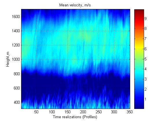
3 Appendix to the paper 6.2-O by Felix Yanovsky, Yaroslav Ostrovsky, Vitaly Marchuk, Igor Mazura, Alexander Pitertsev National Aviation University, Kiev, Ukraine The next 9 figures show examples of measurable variables time-hight distributions got as results of sounding the widespread rain of September 19, 2001 in Cabauw. One can see the following parameters: 1) Differential Doppler Velocity DDV 2) Differential Reflectivity ZDR 3) Eddy Dissipation Rate EPS 4) Slope Spectral Differential Reflectivity slp szdr 5) Specific Differential Phase Kdp 6) Correlation Coefficient ρ 7) Linear Depolarization Ration LDR 8) Mean Velocity 9) Mean Velocity Difference averaged over 10 profiles for 2 neighboring profiles 10) Mean Velocity Difference for 2 neighboring profiles, each couple was analyzed first, and then the results were averaged over 10 profiles. The software for this processing is described in: Ostrovsky Y.P., Yanovsky F.J., and Rohling H., Software for Dopplerpolarimetric Weather Radar Data Processing, Proceedings International Workshop on Microwave, Radar and Remote Sensing, MRRS-2005, Kiev, Sep , 2006, p

4

5

6
7
8

9 The results of the neural network signal processing procedure as color images for both hydrometeor type classifier (upper panel) and turbulence intensity classifier (lower panel) are shown in the following two figures. Drz=drizzle; Rn=rain; Lds=low density snow; Hds=high density snow; Ws=wet snow; Dg=dry graupel; Wg=wet graupel; Sh=small hail; Lh=large hail; R+h=rain+hail mixture.
Mutah University, P.O. Box 7, Mutah, Al-Karak, 61710, Jordan 2 Department of Electrical Engineering,
 American Journal of Applied Sciences 5 (12): 1764-1768, 2008 ISSN 1546-9239 2008 Science Publications Models for Mixed Ensemble of Hydrometeors and their Use in Calculating the Total Random Cross Section
Snow Microphysical Retrieval Based on Ground Radar Measurements
 Snow Microphysical Retrieval Based on Ground Radar Measurements V. Chandrasekar Colorado State University June 27, 2007 1 Outline Role of inter comparing ground and space borne radar Class of measurements
Utilization of Dual-pol data
 WMO/ASEAN Training Workshop on Weather Radar Data Quality and Standardization Utilization of Dual-pol data 8 February 2018 Hiroshi Yamauchi Observation Department Japan Meteorological Agency Japan Meteorological
2 PROPERTIES OF SNOW PARTI-
 P.67 RETRIEVAL OF MICROPHYSICAL PROPERTIES OF SNOW USING SPECTRAL DUAL POLARIZATION ANALYSIS A.L.J. Spek D.N. Moisseev H.W.J. Russchenberg C.M.H. Unal V. Chandrasekar Delft University of Technology, IRCTR,
P14R.11 INFERENCE OF MEAN RAINDROP SHAPES FROM DUAL-POLARIZATION DOPPLER SPECTRA OBSERVATIONS
 P14R.11 INFERENCE OF MEAN RAINDROP SHAPES FROM DUAL-POLARIZATION DOPPLER SPECTRA OBSERVATIONS Dmitri N. Moisseev and V. Chandrasekar Colorado State University, Fort Collins, CO 1. INTRODUCTION Direct observations
Evaluation of raindrop size distribution. retrievals based on the Doppler spectra. using three beams. Christine Unal
 Evaluation of raindrop size distribution retrievals based on the Doppler spectra using three beams Christine Unal Remote-sensing of the environment (RE) In this talk: Differential reflectivity Z dr cannot
APPLICATION OF SPECTRAL POLARIMETRY TO A HAILSTORM AT LOW ELEVATION ANGLE
 13A.3 1 APPLICATION OF SPECTRAL POLARIMETRY TO A HAILSTORM AT LOW ELEVATION ANGLE T.-Y. Yu 1,2,3,, H. Le 1,2, Y. Wang 4,5, A. Ryzhkov 3,4,5, and M. Kumjian 6 1 School of Electrical and Computer Engineering,
HydroClass TM. Separating meteorological and non-meteorological targets in Vaisala radar systems. Laura C. Alku 8th July 2014
 HydroClass TM Separating meteorological and non-meteorological targets in Vaisala radar systems 8th July 2014 HydroClass Software for hydrometeor classification Uses dual polarization observations Utilizes
Observation strategies for severe rain in The Netherlands
 Observation strategies for severe rain in The Netherlands Herman Russchenberg Delft University of Technology Challenge the future Our Earth is slowly warming The world population is moving into the cities
ERAD THE SEVENTH EUROPEAN CONFERENCE ON RADAR IN METEOROLOGY AND HYDROLOGY
 Multi-beam raindrop size distribution retrieals on the oppler spectra Christine Unal Geoscience and Remote Sensing, TU-elft Climate Institute, Steinweg 1, 68 CN elft, Netherlands, c.m.h.unal@tudelft.nl
1. Introduction. 2. The data. P13.15 The effect of a wet radome on dualpol data quality
 P3.5 The effect of a wet radome on dualpol data quality Michael Frech Deutscher Wetterdienst Hohenpeissenberg Meteorological Observatory, Germany. Introduction Operational radar systems typically are equipped
A ZDR Calibration Check using Hydrometeors in the Ice Phase. Abstract
 A ZDR Calibration Check using Hydrometeors in the Ice Phase Michael J. Dixon, J. C. Hubbert, S. Ellis National Center for Atmospheric Research (NCAR), Boulder, Colorado 23B.5 AMS 38 th Conference on Radar
Convective Structures in Clear-Air Echoes seen by a Weather Radar
 Convective Structures in Clear-Air Echoes seen by a Weather Radar Martin Hagen Deutsches Zentrum für Luft- und Raumfahrt Oberpfaffenhofen, Germany Weather Radar Weather radar are normally used to locate
EDWARD A. BRANDES* Research Applications Program National Center for Atmospheric Research. and ALEXANDER V. RYZHKOV
 P5.10 HAIL DETECTION WITH POLARIMETRIC RADAR EDWARD A. BRANDES* Research Applications Program National Center for Atmospheric Research and ALEXANDER V. RYZHKOV Cooperative Institute for Mesoscale Meteorological
TIME EVOLUTION OF A STORM FROM X-POL IN SÃO PAULO: 225 A ZH-ZDR AND TITAN METRICS COMPARISON
 TIME EVOLUTION OF A STORM FROM X-POL IN SÃO PAULO: 225 A ZH-ZDR AND TITAN METRICS COMPARISON * Roberto V Calheiros 1 ; Ana M Gomes 2 ; Maria A Lima 1 ; Carlos F de Angelis 3 ; Jojhy Sakuragi 4 (1) Voluntary
Oleg A. Krasnov 1 and Herman W. J. Russchenberg Introduction. 2. The results and discussion.
 6.12 An Application of the LWC Retrieval Radar-Lidar Technique to the Cloudnet and ARM Data: the Comparison with Microwave Radiometer and Numerical Weather Models Oleg A. Krasnov 1 and Herman W. J. Russchenberg
The Sensitivity of X Band Polarimetric Radar Observables to Melting Hails
 The Sensitivity of X Band Polarimetric Radar Observables to Melting Hails Xinxin Xie, Raquel Evaristo, Silke Trömel and Clemens Simmer Meteorological Institute, University of Bonn, Bonn, Germany Vivek
An Adaptive Neural Network Scheme for Radar Rainfall Estimation from WSR-88D Observations
 2038 JOURNAL OF APPLIED METEOROLOGY An Adaptive Neural Network Scheme for Radar Rainfall Estimation from WSR-88D Observations HONGPING LIU, V.CHANDRASEKAR, AND GANG XU Colorado State University, Fort Collins,
Detailed flow, hydrometeor and lightning characteristics of an isolated, hail producing thunderstorm during COPS
 Detailed flow, hydrometeor and lightning characteristics of an isolated, hail producing thunderstorm during COPS, Martin Hagen, Hartmut Höller, Hans Volkert Institut für Physik der Atmosphäre, DLR Oberpfaffenhofen
Ground-Based Atmospheric Remote Sensing in the Netherlands: European Outlook
 2252 INVITED PAPER Special Section on 2004 International Symposium on Antennas and Propagation Ground-Based Atmospheric Remote Sensing in the Netherlands: European Outlook Herman RUSSCHENBERG a), Fred
Chapter 2: Polarimetric Radar
 Chapter 2: Polarimetric Radar 2.1 Polarimetric radar vs. conventional radar Conventional weather radars transmit and receive linear electromagnetic radiation whose electric field is parallel to the local
Rainfall rate retrieval with IDRA, the polarimetric X-band radar at Cabauw, Netherlands
 Rainfall rate retrieval with IDRA, the polarimetric X-band radar at Cabauw, Netherlands Tobias Otto and Herman W.J. Russchenberg TU Delft Climate Institute, Department of Geoscience and Remote Sensing,
Non-negative K DP Estimation by Monotone Increasing Φ DP Assumption below Melting Layer
 on-negative K DP Estimation by Monotone Increasing Φ DP Assumption below Melting Layer Takeshi Maesaka 1, Koyuru Iwanami 1 and Masayuki Maki 1 1 ational Research Institute for Earth Science and Disaster
Shipborne polarimetric weather radar: Impact of ship movement on polarimetric variables
 Shipborne polarimetric weather radar: Impact of ship movement on polarimetric variables M. Thurai 1, P. T. May and A. Protat 1 Colorado State Univ., Fort Collins, CO Center for Australian Weather and Climate
11B.3 ADAPTIVE TECHNIQUE TO EXTRACT INTRINSIC INSECTS BACKSCATTER DIFFERENTIAL PHASE FROM POLARIMETRIC SPECTRA
 11B.3 ADAPTIVE TECHNIQUE TO EXTRACT INTRINSIC INSECTS BACKSCATTER DIFFERENTIAL PHASE FROM POLARIMETRIC SPECTRA Svetlana Bachmann* and Dusan Zrnic Cooperative Institute for Mesoscale Meteorological Studies,
Reprint 850. Within the Eye of Typhoon Nuri in Hong Kong in C.P. Wong & P.W. Chan
 Reprint 850 Remote Sensing Observations of the Subsidence Zone Within the Eye of Typhoon Nuri in Hong Kong in 2008 C.P. Wong & P.W. Chan 8 th International Symposium on Tropospheric Profiling: Integration
ON COMBINING AMSU AND POLAR MM5 OUTPUTS TO DETECT PRECIPITATING CLOUDS OVER ANTARCTICA
 ON COMBINING AMSU AND POLAR MM5 OUTPUTS TO DETECT PRECIPITATING CLOUDS OVER ANTARCTICA Stefano Dietrich, Francesco Di Paola, Elena Santorelli (CNR-ISAC, Roma, Italy) 2nd Antarctic Meteorological Observation,
Active rain-gauge concept for liquid clouds using W-band and S-band Doppler radars
 Active rain-gauge concept for liquid clouds using W-band and S-band Doppler radars Leyda León-Colón *a, Sandra L. Cruz-Pol *a, Stephen M. Sekelsky **b a Dept. of Electrical and Computer Engineering, Univ.
Polarization Diversity for the National Weather Service (NWS), WSR-88D radars
, WSR-88D radars") Polarization Diversity for the National Weather Service (NWS), WSR-88D radars Dusan S. Zrnic National Severe Storm Laboratory Norman, OK 73069, USA In the early eighties the NOAA s National Severe Storms
Polarization Diversity for the National Weather Service (NWS), WSR-88D radars Dusan S. Zrnic National Severe Storm Laboratory Norman, OK 73069, USA In the early eighties the NOAA s National Severe Storms
MICROPHYSICAL AND PRECIPITATION FORMATION PROCESSES AND RADAR SIGNATURES
 MICROPHYSICAL AND PRECIPITATION FORMATION PROCESSES AND RADAR SIGNATURES 4 TH International Workshop on Weather Modification 3 rd Workshop on Cloud Physics 21-22 October 2010 Daegu, Korea Projects Current
Maximum-Likelihood Estimation of Specific Differential Phase and Attenuation in Rain
 IEEE TRANSACTIONS ON GEOSCIENCE AND REMOTE SENSING, VOL. 41, NO. 12, DECEMBER 2003 2771 Maximum-Likelihood Estimation of Specific Differential Phase and Attenuation in Rain V. Santalla del Rio, Member,
Preliminary result of hail detection using an operational S-band polarimetric radar in Korea
 Preliminary result of hail detection using an operational S-band polarimetric radar in Korea Mi-Young Kang 1, Dong-In Lee 1,2, Cheol-Hwan You 2, and Sol-Ip Heo 3 1 Department of Environmental Atmospheric
Vertical structure and precipitation properties in typhoon rainbands
 The 4 th THORPEX-Asia Science workshop, Kunming, China on 31 Oct.-2 Nov. 2012 Vertical structure and precipitation properties in typhoon rainbands Dong-Kyun Kim, Yeon-Hee Kim, Kwan-Young Chung Forecast
Is Spectral Processing Important for Future WSR-88D Radar?
 Is Spectral Processing Important for Future WSR-88D Radar? Carlos A. Rodríguez Rivera University of Puerto Rico, Mayagüez Campus Mentor: Dr. Robert Palmer University of Oklahoma Abstract: Processing speed
Flood Forecasting with Radar
 Flood Forecasting with Radar Miguel Angel Rico-Ramirez m.a.rico-ramirez@bristol.ac.uk Encuentro Internacional de Manejo del Riesgo por Inundaciones, UNAM, 22 th Jan 2013 Talk Outline Rainfall estimation
WAVE PROPAGATION AND SCATTERING IN RANDOM MEDIA
 WAVE PROPAGATION AND SCATTERING IN RANDOM MEDIA AKIRA ISHIMARU UNIVERSITY of WASHINGTON IEEE Antennas & Propagation Society, Sponsor IEEE PRESS The Institute of Electrical and Electronics Engineers, Inc.
ERAD THE EIGHTH EUROPEAN CONFERENCE ON RADAR IN METEOROLOGY AND HYDROLOGY
 ERAD 2014 - THE EIGHTH EUROPEAN CONFERENCE ON RADAR IN METEOROLOGY AND HYDROLOGY Microphysical interpretation of coincident simultaneous and fast alternating horizontal and vertical polarization transmit
Correcting Microwave Precipitation Retrievals for near- Surface Evaporation
 Correcting Microwave Precipitation Retrievals for near- Surface Evaporation The MIT Faculty has made this article openly available. Please share how this access benefits you. Your story matters. Citation
UNIVERSITY OF OKLAHOMA GRADUATE COLLEGE POLARIMETRIC RADAR SIGNATURES IN DAMAGING DOWNBURST PRODUCING THUNDERSTORMS. A thesis
 UNIVERSITY OF OKLAHOMA GRADUATE COLLEGE POLARIMETRIC RADAR SIGNATURES IN DAMAGING DOWNBURST PRODUCING THUNDERSTORMS A thesis SUBMITTED TO THE GRADUATE FACULTY in partial fulfillment of the requirements
Novel Product Line FMCW Cloud Radars
 Novel Product Line RPG Dual Polarization Dual Frequency Scanning Cloud Radar Systems: Configurations and Applications Edited by Dr. Alexander Myagkov and Dr. Thomas Rose 1 2 Benefit from high operation
Winter and summer weather studies using high resolution radar data
 Winter and summer weather studies using high resolution radar data Tim Böhme 1 1 Deutscher Wetterdienst, Frankfurter Str. 135, 63067 Offenbach am Main, Germany (Dated: 29 August 2014) Tim Böhme 1. Introduction
7B.3 A New Surface-based Polarimetric Hydrometeor Classification Algorithm for the WSR-88D Network. Norman, Oklahoma.
 7B.3 A New Surface-based Polarimetric Hydrometeor Classification Algorithm for the WSR-88D Network Terry J. Schuur 1,2, Alexander V. Ryzhkov 1,2, Heather D. Reeves 1,2, J. Krause 1,2, Matthew R. Kumjian
Antenna pattern requirements for 3-PolD weather radar measurements
 Antenna pattern requirements for 3-PolD weather radar measurements JM Pidre-Mosquera 1, M Vera-Isasa 1, and V Santalla del Rio 1 1 EI Telecomunicacion Universidad de Vigo 36310 Vigo SPAIN (Dated: 17 July
Ground-based temperature and humidity profiling using microwave radiometer retrievals at Sydney Airport.
 Ground-based temperature and humidity profiling using microwave radiometer retrievals at Sydney Airport. Peter Ryan Bureau of Meteorology, Melbourne, Australia Peter.J.Ryan@bom.gov.au ABSTRACT The aim
DSD characteristics of a cool-season tornadic storm using C-band polarimetric radar and two 2D-video disdrometers
 DSD characteristics of a cool-season tornadic storm using C-band polarimetric radar and two 2D-video disdrometers M. Thurai 1, W. A. Petersen 2, and L. D. Carey 3 1 Colorado State University, Fort Collins,
Thunderstorm-Scale EnKF Analyses Verified with Dual-Polarization, Dual-Doppler Radar Data
 Thunderstorm-Scale EnKF Analyses Verified with Dual-Polarization, Dual-Doppler Radar Data David Dowell and Wiebke Deierling National Center for Atmospheric Research, Boulder, CO Ensemble Data Assimilation
P.083 SEVERE WEATHER EVENTS DETECTED BY PUERTO RICO S TROPINET DUAL-POLARIZED DOPPLER X-BAND RADARS NETWORK
 P.083 SEVERE WEATHER EVENTS DETECTED BY PUERTO RICO S TROPINET DUAL-POLARIZED DOPPLER X-BAND RADARS NETWORK Leyda León, José Colom, Carlos Wah University of Puerto Rico, Mayagüez Campus, Mayagüez, PR 1.
TOWARDS THE USE OF X-BAND DUAL POLARIMETRIC RADAR RAIN- FALL ESTIMATES IN URBAN HYDROLOGY
 TOWARDS THE USE OF X-BAND DUAL POLARIMETRIC RADAR RAIN- FALL ESTIMATES IN URBAN HYDROLOGY by G. Bruni (1), J.A.E. ten Veldhuis (1), T. Otto (2) and H. Leijnse (3) (1) Watermanagement Department, Delft
Examining the effect of the vertical wind shear environment on polarimetric signatures in numerically-simulated supercells
 Examining the effect of the vertical wind shear environment on polarimetric signatures in numerically-simulated supercells Jeffrey C. Snyder 1, H. B. Bluestein 1, D. T. Dawson II 2, and Y. Jung 2 1 School
RPG Dual Polarization Dual Frequency Scanning Cloud Radar Systems: Configurations and Applications
 RPG Dual Polarization Dual Frequency Scanning Cloud Radar Systems: Configurations and Applications Edited by Dr. Alexander Myagkov and Dr. Thomas Rose RPG Radiometer Physics GmbH Werner-von-Siemens-Str.
WLS70: A NEW COMPACT DOPPLER WIND LIDAR FOR BOUNDARY LAYER DYNAMIC STUDIES.
 WLS70: A NEW COMPACT DOPPLER WIND LIDAR FOR BOUNDARY LAYER DYNAMIC STUDIES. VALIDATION RESULTS AND INTERCOMPARISON IN THE FRAME OF THE 8TH CIMO-WMO CAMPAIGN. S. Lolli 1, L.Sauvage 1, M. Boquet 1, 1 Leosphere,
POLARIMETRIC AVIONIC WEATHER RADAR FOR INCREASING FLIGHT SAFETY AND EFFICIENCY
 POLARIMETRIC AVIONIC WEATHER RADAR FOR INCREASING FLIGHT SAFETY AND EFFICIENCY Alberto Lupidi, Stefano Lischi, Fabrizio Berizzi, Marco Martorella, Fabrizio Cuccoli RaSS National Laboratory, CNIT (National
Parametrizing cloud and precipitation in today s NWP and climate models. Richard Forbes
 Parametrizing cloud and precipitation in today s NWP and climate models Richard Forbes (ECMWF) with thanks to Peter Bechtold and Martin Köhler RMetS National Meeting on Clouds and Precipitation, 16 Nov
Impact of seasonal variation of raindrop size distribution (DSD) on DSD retrieval methods based on polarimetric radar measurements
 on DSD retrieval methods based on polarimetric radar measurements") Impact of seasonal variation of raindrop size distribution (DSD) on DSD retrieval methods based on polarimetric radar measurements K.Amar Jyothi 1, T.Narayana Rao 2, S.Vijaya Bhaskara Rao 3, S.Rajendran
Impact of seasonal variation of raindrop size distribution (DSD) on DSD retrieval methods based on polarimetric radar measurements K.Amar Jyothi 1, T.Narayana Rao 2, S.Vijaya Bhaskara Rao 3, S.Rajendran
ABB Remote Sensing Atmospheric Emitted Radiance Interferometer AERI system overview. Applications
 The ABB Atmospheric Emitted Radiance Interferometer AERI provides thermodynamic profiling, trace gas detection, atmospheric cloud aerosol study, air quality monitoring, and more. AERI high level overview
Remote Sensing Observations AOSC 200 Tim Canty
 Remote Sensing Observations AOSC 200 Tim Canty Class Web Site: http://www.atmos.umd.edu/~tcanty/aosc200 Topics for today: Maps Radar Satellite Observations Lecture 04 Feb 7 2019 1 Today s Weather Map http://www.wpc.ncep.noaa.gov/sfc/namussfcwbg.gif
ON LINE ARCHIVE OF STORM PENETRATING DATA
 ON LINE ARCHIVE OF STORM PENETRATING DATA Matthew Beals, Donna V. Kliche, and Andrew G. Detwiler Institute of Atmospheric Sciences, South Dakota School of Mines and Technology, Rapid City, SD Steve Williams
C-RITE Workshop Physical Processes in Convection Lawrence Carey
 Lightning Image Courtesy Phillip Bitzer Lightning Image Courtesy Phillip Bitzer C-RITE Workshop Physical Processes in Convection Lawrence Carey 5/23/2017 C-RITE - Cloud Electricity and Lightning 1 Properties
Thunderstorm Forecasting by using Artificial Neural Network
 Thunderstorm Forecasting by using Artificial Neural Network N.F Nik Ismail, D. Johari, A.F Ali, Faculty of Electrical Engineering Universiti Teknologi MARA 40450 Shah Alam Malaysia nikfasdi@yahoo.com.my
Remote Sensing in Meteorology: Satellites and Radar. AT 351 Lab 10 April 2, Remote Sensing
 Remote Sensing in Meteorology: Satellites and Radar AT 351 Lab 10 April 2, 2008 Remote Sensing Remote sensing is gathering information about something without being in physical contact with it typically
Validation of MÉRA total precipitation at Stornoway (Scotland) with a 24 GHz micro rain radar: A Preliminary Investigation
 with a 24 GHz micro rain radar: A Preliminary Investigation") Validation of MÉRA total precipitation at Stornoway (Scotland) with a 24 GHz micro rain radar: A Preliminary Investigation Dr. Edward Graham 1 and Dr. Chris Kidd 2 1 University of the Highlands and Islands,
Validation of MÉRA total precipitation at Stornoway (Scotland) with a 24 GHz micro rain radar: A Preliminary Investigation Dr. Edward Graham 1 and Dr. Chris Kidd 2 1 University of the Highlands and Islands,
CHARACTERISATION OF STORM SEVERITY BY USE OF SELECTED CONVECTIVE CELL PARAMETERS DERIVED FROM SATELLITE DATA
 CHARACTERISATION OF STORM SEVERITY BY USE OF SELECTED CONVECTIVE CELL PARAMETERS DERIVED FROM SATELLITE DATA Piotr Struzik Institute of Meteorology and Water Management, Satellite Remote Sensing Centre
J1.2 Short-term wind forecasting at the Hong Kong International Airport by applying chaotic oscillatory-based neural network to LIDAR data
 J1.2 Short-term wind forecasting at the Hong Kong International Airport by applying chaotic oscillatory-based neural network to LIDAR data K.M. Kwong Hong Kong Polytechnic University, Hong Kong, China
Tr a n s r e g i o n a l C o l l a b o r a t i v e Re s e a r c h C e n t r e TR 172
 Tr a n s r e g i o n a l C o l l a b o r a t i v e Re s e a r c h C e n t r e TR 172 ArctiC Amplification: Climate Relevant Atmospheric and SurfaCe Processes, and Feedback Mechanisms (AC) 3 Towards a better
Dual-Wavelength Polarimetric Radar Analysis of the May 20th 2013 Moore, OK, Tornado
 Dual-Wavelength Polarimetric Radar Analysis of the May 20th 2013 Moore, OK, Tornado Alexandra Fraire Borunda California State University Fullerton, Fullerton, CA Casey B. Griffin and David J. Bodine Advanced
Characterization of Rainfall C-Band Radar Response and Dual-Polarized Measurement for an Hailstorm Event in the Po valley
 Characterization of Rainfall C-Band Radar Response and Dual-Polarized Measurement for an Hailstorm Event in the Po valley K. De Sanctis (1), M. Montopoli (1), F. S. Marzano (1,3), L.Molini (2), A. Parodi
NOTES AND CORRESPONDENCE. On the Use of 50-MHz RASS in Thunderstorms
 936 JOURNAL OF ATMOSPHERIC AND OCEANIC TECHNOLOGY VOLUME 0 NOTES AND CORRESPONDENCE On the Use of 50-MHz RASS in Thunderstorms PETER T. MAY Bureau of Meteorology Research Centre, Melbourne, Victoria, Australia
PRECIPITATION TYPE AND RAINFALL INTENSITY FROM THE PLUDIX DISDROMETER DURING THE WASSERKUPPE CAMPAIGN
 PRECIPITATION TYPE AND RAINFALL INTENSITY FROM THE PLUDIX DISDROMETER DURING THE WASSERKUPPE CAMPAIGN Clelia Caracciolo1, Franco Prodi1,2, Leo Pio D Adderio2 and Eckhard Lanzinger4 1 University of Ferrara,
Precipitation Induced Signatures in SAR Images
 Precipitation Induced Signatures in SAR Images Andreas Danklmayer #1, Madhukar Chandra 2 # Microwaves and Radar Institute, German Aerospace Center(DLR) PO Box 1116, D - 82230 Wessling, Germany 1 Andreas.Danklmayer@dlr.de
Estimation of Vertical Distributions of Water Vapor from Spaceborne Observations of Scattered Sunlight
 Estimation of Vertical Distributions of Water Vapor from Spaceborne Observations of Scattered Sunlight Dale P. Winebrenner Applied Physics Laboratory, Box 355640 University of Washington Seattle, WA 98195
Warning procedures for extreme events in the Emilia-Romagna Region
 Warning procedures for extreme events in the Emilia-Romagna Region Anna Fornasiero, Miria Celano, Roberta Amorati, Virginia Poli and Pier Paolo Alberoni Arpa Emilia-Romagna Hydro-Meteo-Climate Service,
Department of Civil Protection, Prime Ministry, Rome, Italy 2. Department of Atmospheric and Oceanic Sciences, McGill University, Montreal, Canada 3
 P14.25 EXTENSIVE VALIDATION OF A REGULARIZED NEURAL-NETWORK TECHNIQUE FOR S-BAND POLARIMETRIC RADAR RAINFALL ESTIMATION Gianfranco Vulpiani 1, Scott Giangrande 2, and Frank S. Marzano 3 1 Department of
Validation of Hydrometeor Classification Method for X-band Polarimetric Radars using In Situ Observational Data of Hydrometeor Videosonde
 Validation of Hydrometeor Classification Method for X-band Polarimetric Radars using In Situ Observational Data of Hydrometeor Videosonde Takeharu Kouketsu 1*, Hiroshi Uyeda 1, Mariko Oue 1, Tadayasu Ohigashi
IMPROVEMENTS OF POLARIMETRIC RADAR ECHO CLASSIFICATIONS. Ronald Hannesen* Selex-Gematronik, Neuss, Germany
 P13.14 IMPROVEMENTS OF POLARIMETRIC RADAR ECHO CLASSIFICATIONS Ronald Hannesen* Selex-Gematronik, Neuss, Germany 1. INTRODUCTION A two-step radar echo classification is applied on polarimetric radar data:
Radar-derived Quantitative Precipitation Estimation Using a Hybrid Rate Estimator Based On Hydrometeor Type
 Radar-derived Quantitative Precipitation Estimation Using a Hybrid Rate Estimator Based On Hydrometeor Type Michael J. Dixon, S. M. Ellis, T. M. Weckwerth and J. W. Wilson National Center for Atmospheric
The first tropospheric wind profiler observations of a severe typhoon over a coastal area in South China
 The first tropospheric wind profiler observations of a severe typhoon over a coastal area in South China Lei Li, 1 Pak Wai Chan, 2 Honglong Yang, 1 Rong Zong, 1 Xia Mao, 1 Yin Jiang 1 and Hongbo Zhuang
ARTIFICIAL NEURAL NETWORKS گروه مطالعاتي 17 بهار 92
 ARTIFICIAL NEURAL NETWORKS گروه مطالعاتي 17 بهار 92 BIOLOGICAL INSPIRATIONS Some numbers The human brain contains about 10 billion nerve cells (neurons) Each neuron is connected to the others through 10000
Global Instability Index: Product Guide
 Doc.No. Issue : : EUM/TSS/MAN/15/802106 v1c e-signed EUMETSAT Eumetsat-Allee 1, D-64295 Darmstadt, Germany Tel: +49 6151 807-7 Fax: +49 6151 807 555 Date : 2 September 2015 http://www.eumetsat.int WBS/DBS
Ricardo Reinoso-Rondinel 1, Guendalina Bruni 2, Marie-Claire ten Veldhuis 2 and Herman Russchenberg 1. Abstract
 119 1 TOWARD THE OPTIMAL RESOLUTION OF RAINFALL ESTIMATES TO OBTAIN RELIABLE URBAN HYDROLOGICAL RESPONSE: X-BAND POLARIMETRIC RADAR ESTIMATES APPLIED TO ROTTERDAM URBAN DRAINAGE SYSTEM Ricardo Reinoso-Rondinel
WMO Aeronautical Meteorology Scientific Conference 2017
 Session 1 Science underpinning meteorological observations, forecasts, advisories and warnings 1.1 En route phenomena 1.1.1 Ice crystal icing, and airframe icing research Signatures of supercooled liquid
Nowcasting of Severe Weather from Satellite Images (for Southern
 Nowcasting of Severe Weather from Satellite Images (for Southern Europe) Petra Mikuš Jurković Forecasting/ nowcasting of convective storms NWP models cannot well predict the exact location and intesity
The impact of wet radome on the quality of polarimetric measurements. January 5, 2010
 The impact of wet radome on the quality of polarimetric measurements 1. Introduction January 5, 2010 It is well known that wet radome causes attenuation of microwave radiation. Such a transmission loss
ECHO CLASSIFICATION AND SPECTRAL PROCESSING FOR THE DISCRIMINATION OF CLUTTER FROM WEATHER
 P4R.6 ECHO CLASSIFICATION AND SPECTRAL PROCESSING FOR THE DISCRIMINATION OF CLUTTER FROM WEATHER Michael Dixon, Cathy Kessinger and John Hubbert National Center for Atmospheric Research*, Boulder, Colorado
Analysis of severe convective events from two operational dual polarisation doppler radars
 Nat. Hazards Earth Syst. Sci., 6, 397 405, 2006 Author(s) 2006. This work is licensed under a Creative Commons License. Natural Hazards and Earth System Sciences Analysis of severe convective events from
ERAD THE EIGHTH EUROPEAN CONFERENCE ON RADAR IN METEOROLOGY AND HYDROLOGY
 Discrimination Between Winter Precipitation Types Based on Explicit Microphysical Modeling of Melting and Refreezing in the Polarimetric Hydrometeor Classification Algorithm 1 Introduction The winter weather
Investigation of the Air-Wave-Sea Interaction Modes Using an Airborne Doppler Wind Lidar: Analyses of the HRDL data taken during DYNAMO
 DISTRIBUTION STATEMENT: Approved for public release, distribution is unlimited. Investigation of the Air-Wave-Sea Interaction Modes Using an Airborne Doppler Wind Lidar: Analyses of the HRDL data taken
Tropical Rainfall Rate Relations Assessments from Dual Polarized X-band Weather Radars
 Tropical Rainfall Rate Relations Assessments from Dual Polarized X-band Weather Radars Carlos R. Wah González, José G. Colom Ustáriz, Leyda V. León Colón Department of Electrical and Computer Engineering
High-Resolution Raindrop Size Distribution Retrieval Based on the Doppler Spectrum in the Case of Slant Profiling Radar
 JUNE 2015 U N A L 1191 High-Resolution Raindrop Size Distribution Retrieval Based on the Doppler Spectrum in the Case of Slant Profiling Radar CHRISTINE UNAL Delft University of Technology, Delft, Netherlands
Clouds, Precipitation and their Remote Sensing
 Clouds, Precipitation and their Remote Sensing Prof. Susanne Crewell AG Integrated Remote Sensing Institute for Geophysics and Meteorology University of Cologne Susanne Crewell, Kompaktkurs, Jülich 24.
Implementation Guidance of Aeronautical Meteorological Observer Competency Standards
 Implementation Guidance of Aeronautical Meteorological Observer Competency Standards The following guidance is supplementary to the AMP competency Standards endorsed by Cg-16 in Geneva in May 2011. Please
PARCWAPT Passive Radiometry Cloud Water Profiling Technique
 PARCWAPT Passive Radiometry Cloud Water Profiling Technique By: H. Czekala, T. Rose, Radiometer Physics GmbH, Germany A new cloud liquid water profiling technique by Radiometer Physics GmbH (patent pending)
Hail nowcast exploiting radar and satellite observations
 Federal Department of Home Affairs FDHA Federal Office of Meteorology and Climatology MeteoSwiss Hail nowcast exploiting radar and satellite observations Ulrich Hamann, Elena Leonarduzzi, Kristopher Bedka,
Maps and Remote Sensing AOSC 200 Tim Canty
 Maps and Remote Sensing AOSC 200 Tim Canty Class Web Site: http://www.atmos.umd.edu/~tcanty/aosc200 Topics for today: Weather Maps Radar Satellite Observations Lecture 04 Feb 7 2019 1 Today s Weather Map
Analysis of the Temporal Behavior of Coherent Scatterers (CSs) in ALOS PalSAR Data
 in ALOS PalSAR Data") Analysis of the Temporal Behavior of Coherent Scatterers (CSs) in ALOS PalSAR Data L. Marotti, R. Zandona-Schneider & K.P. Papathanassiou German Aerospace Center (DLR) Microwaves and Radar Institute0 PO.BOX
Analysis of the Temporal Behavior of Coherent Scatterers (CSs) in ALOS PalSAR Data L. Marotti, R. Zandona-Schneider & K.P. Papathanassiou German Aerospace Center (DLR) Microwaves and Radar Institute0 PO.BOX
The next generation in weather radar software.
 The next generation in weather radar software. PUBLISHED BY Vaisala Oyj Phone (int.): +358 9 8949 1 P.O. Box 26 Fax: +358 9 8949 2227 FI-00421 Helsinki Finland Try IRIS Focus at iris.vaisala.com. Vaisala
Abstract 1 INTRODUCTION OF WATER CLOUD PARAMETERS 1R.4 RADAR-LIDAR SYNERGY FOR SPACE-BASED RETRIEVAL
 1R.4 RADAR-LIDAR SYNERGY FOR SPACE-BASED RETRIEVAL OF WATER CLOUD PARAMETERS Gregory May Herman Russchenberg Oleg Krasnov Delft University of Technology, IRCTR, Delft, The Netherlands Abstract Knowledge
A Method for Estimating Rain Rate and Drop Size Distribution from Polarimetric Radar Measurements
 830 IEEE TRANSACTIONS ON GEOSCIENCE AND REMOTE SENSING, VOL. 39, NO. 4, APRIL 2001 A Method for Estimating Rain Rate and Drop Size Distribution from Polarimetric Radar Measurements Guifu Zhang, J. Vivekanandan,
118 RECONSTRUCTION OF RADAR RFLECTIVITY IN CLUTTER AREAS
 8 RECONSTRUCTION OF RADAR RFLECTIVITY IN CLUTTER AREAS Shinju Park, Marc Berenguer Centre de Recerca Aplicada en Hidrometeorologia, Universitat Politècnica de Catalunya (BarcelonaTech), Barcelona, Spain..
Optimum Neural Network Architecture for Precipitation Prediction of Myanmar
 Optimum Neural Network Architecture for Precipitation Prediction of Myanmar Khaing Win Mar, Thinn Thu Naing Abstract Nowadays, precipitation prediction is required for proper planning and management of
Climate & Earth System Science. Introduction to Meteorology & Climate. Chapter 05 SOME OBSERVING INSTRUMENTS. Instrument Enclosure.
 Climate & Earth System Science Introduction to Meteorology & Climate MAPH 10050 Peter Lynch Peter Lynch Meteorology & Climate Centre School of Mathematical Sciences University College Dublin Meteorology