Climatology of dry air intrusions and their relation to strong surface winds in extratropical cyclones
|
|
|
- Andrew Griffith
- 6 years ago
- Views:
Transcription
1 Climatology of dry air intrusions and their relation to strong surface winds in extratropical cyclones...and intro to synoptic and meso-scale cyclone dynamics Shira Raveh-Rubin and Heini Wernli Institute for Atmospheric and Climate Science (IACETH), ETH Zurich 5 th European Windstorm Workshop StormEx, Bern, 31 August 2015


2 Impact of cyclones what? strong damaging surface winds extended heavy precipitation hail, thunderstorm... damage, fatalities, floods, landslides, storm surge, economic losses
3 Impact of cyclones where and when? MODIS on Terra satellite, NASA,12 February 2014

4 Impact of cyclones where and when? cloud head L dry slot 1000 km
5 Impact of cyclones where and when? cloud head L dry slot 1000 km
")
")
6 Impact of cyclones where and when? N. Atlantic composite (~400 cyclones) Surface wind velocity Precipitation rate Field and Wood 2007 (J Climate)

7 Impact of cyclones wind footprint Storm track and max. wind gust speed m/s Born et al., 2012 (Tellus)

8 Storm tracks Cyclone frequency [%] Wernli and Schwierz 2006 (JAS)

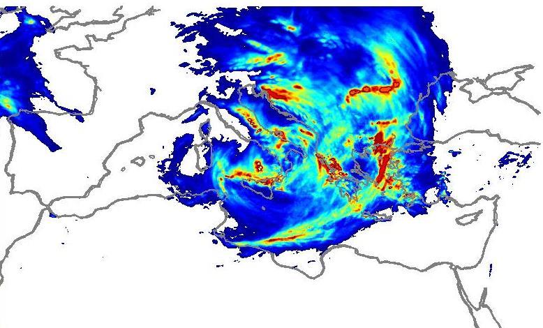
9 Precipitation in intense Mediterranean cyclones mm/6h Flaounas et al., 2015 (Clim Dyn)
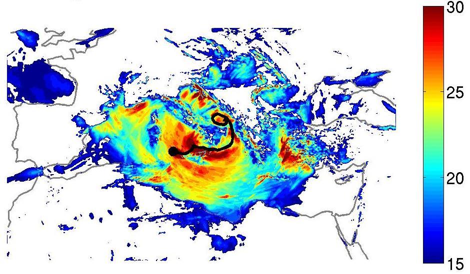
![Co-occurrence of precipitation and gust extremes in Mediterranean Atlantic cyclones Mediterranean cyclones 320-K PV [pvu] 6-h 10-m](/docs-images/74/69715365/images/10-0.jpg "gust > 15 m/s 6-h precipitation > 2 mm/(6h) On average: gust maximum ~12h after precipitation maximum Raveh-Rubin and Wernli 2015")
10 Co-occurrence of precipitation and gust extremes in Mediterranean Atlantic cyclones Mediterranean cyclones 320-K PV [pvu] 6-h 10-m gust > 15 m/s 6-h precipitation > 2 mm/(6h) On average: gust maximum ~12h after precipitation maximum Raveh-Rubin and Wernli 2015 (QJ)
11 Impact of cyclones associated features DAI CCB SJ L WCB warm conveyor belt (WCB) cold conveyor belt (CCB) dry air intrusion (DAI) sting jets (SJ) fronts convection
12 Warm conveyor belts (WCBs) L WCB convection Lagrangian definition and climatology: Madonna et al., 2014 (J Climate)

13 WCBs and precipitation composite of 500 explosively intensifying cyclones associated with a strong WCB > 600 hpa ascent in 48 h Low-level WCB density 315-K 2 PVU 850-hPa wind Hanin Binder Precipitation rate mm/6h

14 WCBs and extreme precipitation % Pfahl et al., 2014 (J Climate)
15 Cold conveyor belt (CCB) and sting jet (SJ) CCB SJ L Review CCB: Schultz 2001 (MWR)
16 Cold conveyor belt (CCB) and sting jet (SJ) CCB SJ cloud head 10-m gust Smart and Browning 2014 (QJ)
 SJ Gray et al., 2011 (QJ)")
17 Cold conveyor belt (CCB) and sting jet (SJ) SJ Gray et al., 2011 (QJ)
18 Dry air intrusions (DAIs) DAI L
19 Browning 1997 (Meteorol. Appl.) Dry air intrusions (DAIs)
20 DAI and extreme surface wind Dry descending air 2 pvu -4 cm/s Moist ascending air Browning and Reynolds 1994 (QJ)
 998 12 UTC")
21 Extreme large-scale wind and precipitation Case study: October 2007 Mediterranean cyclone 2 PVU on 330 K SLP WV (Dundee satellite receiving station) UTC 22/10/2007
22 Total wind and precipitation ERA Interim COSMO 7 [m/s] Maximum 10-m gust Total precipitation [mm /4 days] Convective precipitation

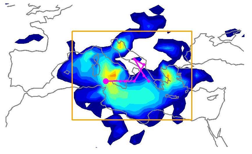
23 Total wind and precipitation ERA Interim COSMO 7 [m/s] Maximum 10-m gust Total precipitation [mm /4 days] Convective precipitation
24 Temporal evolution peak time SLP gust ERA Interim Total prec. Convective prec.
25 Peak wind / precipitation and Lagrangian airstreams Ascending trajectories 500-hPa ascent in 48 h Total 6-h precipitation Descending trajectories 400-hPa descent in 96 h Maximum 6-h gust (at 10 m) Trajectories reaching max. gust Gust > 22 m/s P>900 hpa


26 Peak wind / precipitation and Lagrangian airstreams Ascending trajectories 500-hPa ascent in 48 h Total 6-h precipitation Descending trajectories 400-hPa descent in 96 h Maximum 6-h gust (at 10 m) Trajectories reaching max. gust Gust > 22 m/s P>900 hpa # # hpa 12 UTC, 22 October 2007
![COSMO 7 12 UTC, 22 October 2007 RH [%] PV>2 pvu Wind vel.](/docs-images/74/69715365/images/27-1.jpg "> 20 m/s θe 10-m gust SLP gust Total prec. Total precipitation Convective prec.")
27 COSMO 7 12 UTC, 22 October 2007 RH [%] PV>2 pvu Wind vel. > 20 m/s θe 10-m gust SLP gust Total prec. Total precipitation Convective prec. Latitude [ N] Convective precipitation

28 COSMO trajectories reaching high gust hpa
![COSMO 7 12 UTC, 22 October 2007 RH [%]](/docs-images/74/69715365/images/29-1.jpg "PV>2 pvu Wind vel.")

29 COSMO 7 12 UTC, 22 October 2007 RH [%] PV>2 pvu Wind vel. > 20 m/s θe 10-m gust SLP gust Total prec. conv. prec. Total precipitation Longitude [ E] Convective precipitation


30 COSMO trajectories which descend strongly 400 hpa in 24 h hpa


31 Observation of shallow convection Channel 10 - IR µm Channel 5 - WV µm Dundee satellite receiving station
32 Case study - summary Large-scale and persistent non-convective precipitation associated with WCB trajectories Large-scale high gust associated with CCB and instability At the cold front environment shallow convection and destabilization by a DAI important for co-location of strong wind and precipitation Strong wind and precipitation are otherwise separated
33 Dry air intrusions Lagrangian definition 400-hPa descent in 48 h - ERA Interim - LAGRANTO (Sprenger and Wernli 2015, Geosci. Model Dev.) - Start forward trajectories every 6 h, 80 km, above 600-hPa level

34 Dry air intrusions Lagrangian definition 400-hPa descent in 48 h hpa Start at _06
35 DJF Dry air intrusions climatology # / (6h deg 2 ) 0 h +48 h

")
36 JJA Dry air intrusions climatology # / (6h deg 2 ) 0 h +48 h

 0 h +48 h")
37 DJF Dry air intrusions climatology # / (6h deg 2 ) 0 h +48 h Pacific Atlantic
38 Atlantic / DJF Temporal evolution P [hpa] θ [K] q [g kg -1 ] PV [pvu] RH [%] Time [hr]
39 Pacific / DJF Temporal evolution P [hpa] θ [K] q [g kg -1 ] PV [pvu] RH [%] Time [hr]
40 Dry air intrusions outlook How do DAIs interact with cyclones? What is the origin of DAIs? What initiates DAIs? What is the impact of DAIs on extreme weather at the surface?
41 Thank you!
Diabatic processes and the structure of the warm conveyor belt
 2 nd European Windstorm Workshop Leeds, 3-4 September 2012 Diabatic processes and the structure of the warm conveyor belt Oscar Martínez-Alvarado J. Chagnon, S. Gray, R. Plant, J. Methven Department of
Microphysical heating rates and PV modification in a warm conveyor belt: Comparison of a COSMO and IFS simulation
 Microphysical heating rates and PV modification in a warm conveyor belt: Comparison of a COSMO and IFS simulation Montreal, August 18th 2014 H. Joos1, M. Böttcher1, R. Forbes2 and H. Wernli1 1) IAC, ETH
Extratropical and Polar Cloud Systems
 Extratropical and Polar Cloud Systems Gunilla Svensson Department of Meteorology & Bolin Centre for Climate Research George Tselioudis Extratropical and Polar Cloud Systems Lecture 1 Extratropical cyclones
Large-scale wind and precipitation extremes in the Mediterranean: dynamical aspects of five selected cyclone events
 Quarterly Journal of the Royal Meteorological Society Q. J. R. Meteorol. Soc. 142: 397 3114, October 216 B DOI:1.12/qj.2891 Large-scale wind and precipitation extremes in the Mediterranean: dynamical aspects
Diabatic processes and the structure of extratropical cyclones
 Geophysical and Nonlinear Fluid Dynamics Seminar AOPP, Oxford, 23 October 2012 Diabatic processes and the structure of extratropical cyclones Oscar Martínez-Alvarado R. Plant, J. Chagnon, S. Gray, J. Methven
Extratropical processes and forecast errors
 Extratropical processes and forecast errors Heini Wernli With contributions from: Andreas Dörnbrack, Sarah Jones, George Craig Maxi Böttcher, Hanna Joos, Andreas Schäfler, Matthias Zimmer, Florian Meier,
An interactive method to predict warm conveyor belt occurrence for aircraft-based field campaigns
 Technische Universität München An interactive method to predict warm conveyor belt occurrence for aircraft-based field campaigns Marc Rautenhaus(1), Christian Grams(2), Michael Kern(1), Andreas Schäfler(3)
Mid-Latitude Dynamics and Atmospheric Rivers
 Mid-Latitude Dynamics and Atmospheric Rivers Session: Theory, Structure, Processes 1 Wednesday, 10 August 2016 Contribution from: Heini Werni Peter Knippertz Harold Sodemann Andreas Stohl Francina Dominguez
Satellites, Weather and Climate Module 9: Air/sea interactions winter cyclogenesis
 Satellites, Weather and Climate Module 9: Air/sea interactions winter cyclogenesis Winter storms things to consider Deep moisture Thermal discontinuity Favorable surface and upper level features Geographical
Boundary layer controls on extratropical cyclone development
 Boundary layer controls on extratropical cyclone development R. S. Plant (With thanks to: I. A. Boutle and S. E. Belcher) 28th May 2010 University of East Anglia Outline Introduction and background Baroclinic
AN EXTRATROPICAL CYCLONE ATLAS
 AN EXTRATROPICAL CYCLONE ATLAS A tool for illustrating cyclone structure and evolution characteristics BY H. F. DACRE, M. K. HAWCROFT, M. A. STRINGER AND K. I. HODGES Authors Affiliations H.F.Dacre, Department
Supplemental material. The role of warm conveyor belts for the intensification of extratropical cyclones in Northern Hemisphere winter
 Supplemental material The role of warm conveyor belts for the intensification of extratropical cyclones in Northern Hemisphere winter HANIN BINDER, MAXI BOETTCHER, HANNA JOOS AND HEINI WERNLI Institute
The role of individual synoptic-scale weather systems in the life cycle of European weather regimes
 The role of individual synoptic-scale weather systems in the life cycle of European weather regimes Christian M. Grams Institute for Atmospheric and Climate Science, ETH Zürich, Switzerland funded by thanks
Radiative contribution to the North-American cold air outbreaks in a Lagrangian perspective
 Radiative contribution to the North-American cold air outbreaks in a Lagrangian perspective Natalia Bliankinshtein, Y. Huang, J. R. Gyakum and E. Atallah Department of Atmospheric and Oceanic Sciences
What does a cloud-resolving model bring during an extratropical transition?
 What does a cloud-resolving model bring during an extratropical transition? Florian Pantillon (1) Jean-Pierre Chaboureau (1) Christine Lac (2) Patrick Mascart (1) (1) Laboratoire d'aérologie, Toulouse,
1. COLD FRONT - CLOUD STRUCTURE IN SATELLITE IMAGES
 1. COLD FRONT - CLOUD STRUCTURE IN SATELLITE IMAGES The satellite image shows a cyclonically curved synoptic scale cloud band usually a few hundred kilometres wide; in the VIS image the cloud band mostly
The link between atmospheric blockings and Central European flood events a case study
 Workshop on Atmospheric Blocking, 6-8 April 2016, Reading, UK The link between atmospheric blockings and Central European flood events a case study Sina Lenggenhager 1,2, Olivia Martius 1,2, Stefan Brönnimann
The influence of mid-latitude cyclones on European background surface ozone
 1 The influence of mid-latitude cyclones on European background surface ozone K. Emma Knowland (USRA/GESTAR NASA/GMAO) In collaboration with: Ruth Doherty (U. Edinburgh) Kevin Hodges (U. Reading) Lesley
Meteorological Applications. Objective detection of sting jets in low-resolution datasets
 Objective detection of sting jets in low-resolution datasets Journal: Meteorological Applications Manuscript ID: MET--00 Wiley - Manuscript type: Research Article Date Submitted by the Author: -Mar- Complete
Flying through extratropical cyclone Friedhelm
 Flying through extratropical cyclone Friedhelm Laura Baker 1, Oscar Martinez-Alvarado 1, John Methven 1, Peter Knippertz 2 1 Department of Meteorology, University of Reading 2 School of Earth and Environment,
Mesoscale Atmospheric Systems. Surface fronts and frontogenesis. 06 March 2018 Heini Wernli. 06 March 2018 H. Wernli 1
 Mesoscale Atmospheric Systems Surface fronts and frontogenesis 06 March 2018 Heini Wernli 06 March 2018 H. Wernli 1 Temperature (degc) Frontal passage in Mainz on 26 March 2010 06 March 2018 H. Wernli
Occlusion cyclogenesis II
 Occlusion cyclogenesis II Upper level influences on cyclogenesis Vorticity Advection (CVA) and the 4-quadrant jet streak model (Uccellini) Potential Vorticity (PV) (Hoskins Theory) Rapid cyclogenesis 14
Distinguishing the cold conveyor belt and sting jet air streams in an intense extratropical cyclone
 Distinguishing the cold conveyor belt and sting jet air streams in an intense extratropical cyclone Article Accepted Version Postprint Martinez Alvarado, O., Baker, L. H., Gray, S. L., Methven, J. and
Objective detection of sting jets in low-resolution datasets
 METEOROLOGICAL APPLICATIONS Meteorol. Appl. 20: 41 55 (2013) Published online 4 October 2011 in Wiley Online Library (wileyonlinelibrary.com) DOI: 10.1002/met.297 Objective detection of sting jets in low-resolution
Detection of coherent airstreams using cluster analysis: application to an extratropical cyclone
 Detection of coherent airstreams using cluster analysis: application to an extratropical cyclone Article Accepted Version Hart, N. C. G., Gray, S. L. and Clark, P. A. (2015) Detection of coherent airstreams
Multiscale Analyses of Inland Tropical Cyclone Midlatitude Jet Interactions: Camille (1969) and Danny (1997)
 and Danny (1997)") Multiscale Analyses of Inland Tropical Cyclone Midlatitude Jet Interactions: Camille (1969) and Danny (1997) Matthew Potter, Lance Bosart, and Daniel Keyser Department of Atmospheric and Environmental
Multiscale Analyses of Inland Tropical Cyclone Midlatitude Jet Interactions: Camille (1969) and Danny (1997) Matthew Potter, Lance Bosart, and Daniel Keyser Department of Atmospheric and Environmental
The water vapour channels of SEVIRI (Meteosat). An introduction
. An introduction") The water vapour channels of SEVIRI (Meteosat). An introduction jose.prieto@eumetsat.int Cachoeira P. July 2006 Formats 1.5 1 Objectives 2 Describe the characteristics of WV channels on board of SEVIRI
The water vapour channels of SEVIRI (Meteosat). An introduction jose.prieto@eumetsat.int Cachoeira P. July 2006 Formats 1.5 1 Objectives 2 Describe the characteristics of WV channels on board of SEVIRI
Why warm conveyor belts matter in NWP
 from Newsletter Number 154 Winter 017/18 METEOROLOGY Why warm conveyor belts matter in NWP doi:10.1957/mr0vg M. Rodwell, R. Forbes, H. Wernli (ETH Zurich) Why warm conveyor belts matter in NWP This article
Florian Meier, Peter Knippertz Johannes Gutenberg-University Mainz
 Sensitivity experiments with the COSMO-Model - the influence of upstream latent heating and wave amplification on a heavy precipitation event over West Africa Florian Meier, Peter Knippertz Johannes Gutenberg-University
How might extratropical storms change in the future? Len Shaffrey National Centre for Atmospheric Science University of Reading
 How might extratropical storms change in the future? Len Shaffrey National Centre for Atmospheric Science University of Reading Extratropical storms Extratropical storms Strong winds, extreme waves, storm
Isentropic Analysis. Much of this presentation is due to Jim Moore, SLU
 Isentropic Analysis Much of this presentation is due to Jim Moore, SLU Utility of Isentropic Analysis Diagnose and visualize vertical motion - through advection of pressure and system-relative flow Depict
5REQUEST FOR A SPECIAL PROJECT
 5REQUEST FOR A SPECIAL PROJECT 2018 2020 MEMBER STATE: Principal Investigator 1 : Affiliation: Address: E-mail: Other researchers: Switzerland This form needs to be submitted via the relevant National
Mesoscale analysis of a comma cloud observed during FASTEX
 Meteorol. Appl. 7, 129 134 (2000) Mesoscale analysis of a comma cloud observed during FASTEX K D Williams, Joint Centre for Mesoscale Meteorology, Department of Meteorology, University of Reading, PO Box
P R O L O G U E CORRELATION COEF. dsst/dt during wintertime (i.e., end of Feb. minus beginning of Dec, using 11-day averaged climatology)
") P R O L O G U E dsst/dt during wintertime (i.e., end of Feb. minus beginning of Dec, using 11-day averaged climatology) Correlation between total precipitable water (from NVAP-M) and total cloud (from
P R O L O G U E dsst/dt during wintertime (i.e., end of Feb. minus beginning of Dec, using 11-day averaged climatology) Correlation between total precipitable water (from NVAP-M) and total cloud (from
Characterizing the role of diabatic processes for the modification of mid-latitude Rossby waves and Jetstream winds
 Characterizing the role of diabatic processes for the modification of mid-latitude Rossby waves and Jetstream winds Andreas Schäfler 1, George Craig 2, Andreas Dörnbrack 1, Florian Harnisch 4, Uwe Marksteiner
WATER VAPOUR IMAGERY ANALYSIS IN 7.3µ/6.2µ FOR DIAGNOSING THERMO-DYNAMIC CONTEXT OF INTENSE CONVECTION
 WATER VAPOUR IMAGERY ANALYSIS IN 7.3µ/6.2µ FOR DIAGNOSING THERMO-DYNAMIC CONTEXT OF INTENSE CONVECTION P. Santurette 1 and C.G. Georgiev 2 1 Météo-France, 42, Avenue G. Coriolis, 31057 Toulouse Cedex 01,
Isentropic Thinking & Airstreams Analysis
 Isentropic Thinking & Airstreams Analysis Drs. James T. Moore & Sam Ng Saint Louis University & Metropolitan State College of Denver Utility of Isentropic Analysis Diagnose and visualize vertical motion
MET 3502 Synoptic Meteorology. Lecture 8: September 16, AIRMASSES, FRONTS and FRONTAL ANALYSIS (2)
") MET 3502 Synoptic Meteorology Lecture 8: September 16, 2010 AIRMASSES, FRONTS and FRONTAL ANALYSIS (2) Identifying a cold front on a surface weather map: 1. Surface front is located at the leading edge
MET 3502 Synoptic Meteorology Lecture 8: September 16, 2010 AIRMASSES, FRONTS and FRONTAL ANALYSIS (2) Identifying a cold front on a surface weather map: 1. Surface front is located at the leading edge
Attribution of strong winds to a cold conveyor belt and sting jet
 Quarterly Journal of the Royal Meteorological Society Q. J. R. Meteorol. Soc. (2013) Attribution of strong winds to a cold conveyor belt and sting jet D. J. Smart a * and K. A. Browning b a University
Rapid cyclogenesis over Poland on 28 March 1997
 Meteorol. Appl. 6, 363 370 (1999) Rapid cyclogenesis over Poland on 28 March 1997 Jan Waclaw Parfiniewicz, Institute of Meteorology and Water Management, ul. Podleœna 61, 01 673 Warszawa, Poland A small
The October 2015 Supercell Storm in Israel
 The October 2015 Supercell Storm in Israel Alissa Razy, Elyakom Vadislavsky, Anat Baharad, Noam Halfon, Itsik Carmona, Yoav Levi, Amit Savir Introduction A high-impact weather event associated with severe
Idealised simulations of sting jet cyclones
 Idealised simulations of sting jet cyclones Article Published Version Baker, L. H., Gray, S. L. and Clark, P. A. (214) Idealised simulations of sting jet cyclones. Quarterly Journal of the Royal Meteorological
THE MAP ROOM. BAND ON THE RUN Chasing the Physical Processes Associated with Heavy Snowfall
 THE MAP ROOM BAND ON THE RUN Chasing the Physical Processes Associated with Heavy Snowfall BY CHARLES E. GRAVES, JAMES T. MOORE, MARC J. SINGER, AND SAM NG AFFILIATIONS: GRAVES, MOORE, AND NG Department
Multi-scale Predictability Aspects of a Severe European Winter Storm
 1 Multi-scale Predictability Aspects of a Severe European Winter Storm NASA MODIS James D. Doyle, C. Amerault, P. A. Reinecke, C. Reynolds Naval Research Laboratory, Monterey, CA Mesoscale Predictability
The Transition of Atmospheric Infrared Sounder Total Ozone Products to Operations
 The Transition of Atmospheric Infrared Sounder Total Ozone Products to Operations Emily Berndt 1, Bradley Zavodsky 2, Gary Jedlovec 2 1 NASA Postdoctoral Program Marshall Space Flight Center, Huntsville,
On the dependence of boundary layer ventilation on frontal type
 JOURNAL OF GEOPHYSICAL RESEARCH, VOL. 114,, doi:10.1029/2008jd010694, 2009 On the dependence of boundary layer ventilation on frontal type A. Agustí-Panareda, 1,2 S. L. Gray, 1 and S. E. Belcher 1 Received
Mesoscale Atmospheric Systems
 Mesoscale Atmospheric Systems Introduction Spring Semester 2018 Heini Wernli Outline of lecture course See also www.iac.ethz.ch/edu/courses/master/modules/mesoscale-atmospheric-systems.html 20 Feb Introduction
Tropical-Extratropical Transition
 Tropical-Extratropical Transition Extratropical Transition A significant number of tropical cyclones move into the midlatitudes and transform into extratropical cyclones. This process is generally referred
Cold-conveyor-belt jet, sting jet and slantwise circulations in idealized simulations of extratropical cyclones
 Quarterly Journalof the Royal Meteorological Society Q. J. R. Meteorol. Soc. 142: 1781 1796, April 2016 B DOI:10.1002/qj.2775 Cold-conveyor-belt jet, sting jet and slantwise circulations in idealized simulations
Weather Patterns and Severe Storms
 Weather Patterns and Severe Storms 20.1 Air Masses Air Masses and Weather Air Masses An air mass is an immense body of air that is characterized by similar temperatures and amounts of moisture at any given
Report from the PDP working group
 Report from the PDP working group Craig Bishop, Pat Harr, Shuhei Maeda, John Methven, Mark Rodwell, Istvan Szunyogh, Olivier Talagrand, Heini Wernli ICSC11 Meeting July 2013 PDP mission Main task of the
Anthony A. Rockwood Robert A. Maddox
 Anthony A. Rockwood Robert A. Maddox An unusually intense MCS produced large hail and wind damage in northeast Kansas and northern Missouri during the predawn hours of June 7 th, 1982. Takes a look at
Tropical Cyclone Genesis: What we know, and what we don t!
 Tropical Cyclone Genesis: What we know, and what we don t! Allison Wing! NSF Postdoctoral Research Fellow! Lamont-Doherty Earth Observatory! Columbia University! Overview! Climatology! What We Know! Theories!
Numerical modelling of the interaction of soil moisture with planetary boundary layer features and convection over West Africa
 Numerical modelling of the interaction of soil moisture with planetary boundary layer features and convection over West Africa Leonhard Gantner, Norbert Kalthoff, and Martin Kohler Photo: J. Schwendike
Chapter 21. Weather Patterns and Severe Storms
 Chapter 21 Weather Patterns and Severe Storms 20.1 Air Masses Air Masses and Weather Air Masses An air mass is an immense body of air that is characterized by similar temperatures and amounts of moisture
Dynamics of the Atmosphere. Large-scale flow with rotation and stratification
 12.810 Dynamics of the Atmosphere Large-scale flow with rotation and stratification Visualization of meandering jet stream Upper level winds from June 10th to July 8th 1988 from MERRA Red shows faster
Occlusion Cyclogenesis
 Occlusion Cyclogenesis Part I: Occlusion cloud bands in comparison to CF and WFs Concepts for cyclogenesis Different types of cyclogenesis and examples Numerical parameters on isobaric and isentropic surfaces
2D.4 THE STRUCTURE AND SENSITIVITY OF SINGULAR VECTORS ASSOCIATED WITH EXTRATROPICAL TRANSITION OF TROPICAL CYCLONES
 2D.4 THE STRUCTURE AND SENSITIVITY OF SINGULAR VECTORS ASSOCIATED WITH EXTRATROPICAL TRANSITION OF TROPICAL CYCLONES Simon T. Lang Karlsruhe Institute of Technology. INTRODUCTION During the extratropical
Shawn M. Milrad Atmospheric Science Program Department of Geography University of Kansas Lawrence, Kansas
 Shawn M. Milrad Atmospheric Science Program Department of Geography University of Kansas Lawrence, Kansas Eyad H. Atallah and John R. Gyakum Department of Atmospheric and Oceanic Sciences McGill University
disturbances in the subtropical jetstream & mechanisms associated with extreme rainfall in South Asia
 disturbances in the subtropical jetstream & mechanisms associated with extreme rainfall in South Asia Kieran M R Hunt, Andrew G Turner & Leonard C Shaffrey WMO 6 th International Workshop for Monsoons,
Impacts of the April 2013 Mean trough over central North America
 Impacts of the April 2013 Mean trough over central North America By Richard H. Grumm National Weather Service State College, PA Abstract: The mean 500 hpa flow over North America featured a trough over
Katherine E. Lukens and E. Hugo Berbery. Acknowledgements: Kevin I. Hodges 1 and Matthew Hawcroft 2. University of Reading, Reading, Berkshire, UK
 Boreal Winter Storm Tracks and Related Precipitation in North America: A Potential Vorticity Perspective Katherine E. Lukens and E. Hugo Berbery Acknowledgements: Kevin I. Hodges 1 and Matthew Hawcroft
Pacific Storm Track at Different Horizontal Resolutions Snap-shot of Column Liquid Water Content
 Color Plates Pacific Storm Track at Different Horizontal Resolutions Snap-shot of Column Liquid Water Content Fig. 2.8 A snapshot of the cyclone frontal-system by a nonhydrostatic model run with two very
Phenomena of synoptic scale
 Chapter 5 Phenomena of synoptic scale 5.1 Analysis of fronts 5.1.1 Concept of fronts A front is defined as a boundary between air masses. At such a boundary, a vertical circulation is excited along the
John Steffen and Mark A. Bourassa
 John Steffen and Mark A. Bourassa Funding by NASA Climate Data Records and NASA Ocean Vector Winds Science Team Florida State University Changes in surface winds due to SST gradients are poorly modeled
High-Resolution MPAS Simulations for Analysis of Climate Change Effects on Weather Extremes
 High-Resolution MPAS Simulations for Analysis of Climate Change Effects on Weather Extremes ALLISON MICHAELIS, GARY LACKMANN, & WALT ROBINSON Department of Marine, Earth, and Atmospheric Sciences, North
Use of potential vorticity fields, Meteosat water vapour imagery and pseudo water vapour images for evaluating numerical model behaviour
 Meteorol. Appl. 8, 57 69 (2001) Use of potential vorticity fields, Meteosat water vapour imagery and pseudo water vapour images for evaluating numerical model behaviour Christo G Georgiev, National Institute
A 40-year climatology of extratropical transition in the eastern North Pacific continued (and some other stuff)
") GOES-EAST image of Hurricane Dora, 1445 UTC 21 July 2011 A 40-year climatology of extratropical transition in the eastern North Pacific continued (and some other stuff) Elizabeth A. Ritchie and Kimberly
GOES-EAST image of Hurricane Dora, 1445 UTC 21 July 2011 A 40-year climatology of extratropical transition in the eastern North Pacific continued (and some other stuff) Elizabeth A. Ritchie and Kimberly
Isolated severe weather and cold air damming 9 November 2005 By Richard H. Grumm National Weather Service Office State College, PA 16801
 Isolated severe weather and cold air damming 9 November 2005 By Richard H. Grumm National Weather Service Office State College, PA 16801 1. INTRODUCTION Two lines of convection moved over the State of
Influence of microphysical processes on the potential vorticity development in a warm conveyor belt: a case-study with the limited-area model COSMO
 Quarterly Journal of the Royal Meteorological Society Q. J. R. Meteorol. Soc. 138: 407 418, January 2012 B Influence of microphysical processes on the potential vorticity development in a warm conveyor
Meteorology. Chapter 10 Worksheet 2
 Chapter 10 Worksheet 2 Meteorology Name: Circle the letter that corresponds to the correct answer 1) Downdrafts totally dominate the in the development of a thunderstorm. a) dissipating stage b) mature
Orography and Monsoons: winter snow-storms over the Himalayas
 Orography and Monsoons: winter snow-storms over the Himalayas Massimo Bollasina1 and Laura Bertolani2 1Experimental 2Epson Climate Prediction Center, CA Meteo Center - Milan CEOP/IGWCO Joint Meeting, Tokyo,
Dynamics of the Atmosphere. General circulation of the atmosphere
 12.810 Dynamics of the Atmosphere General circulation of the atmosphere 1 Spinup of the general circulation in an idealized model Fig. 1 Schneider, General circulation of the atmosphere, 2006 2 Sigma 0.2
Introduction to Meteorology & Climate. Climate & Earth System Science. Atmosphere Ocean Interactions. A: Structure of the Ocean.
 Climate & Earth System Science Introduction to Meteorology & Climate MAPH 10050 Peter Lynch Peter Lynch Meteorology & Climate Centre School of Mathematical Sciences University College Dublin Meteorology
THE EXTRATROPICAL TRANSITION OF TYPHOON WINNIE (1997): SELF-AMPLIFICATION AFTER LANDFALL
: SELF-AMPLIFICATION AFTER LANDFALL") THE EXTRATROPICAL TRANSITION OF TYPHOON WINNIE (1997): SELF-AMPLIFICATION AFTER LANDFALL Chih-Shin Liu *1,2 and George Tai-Jen Chen 2 1 Weather Forecast Center, Central Weather Bureau, 2 Department of
THE EXTRATROPICAL TRANSITION OF TYPHOON WINNIE (1997): SELF-AMPLIFICATION AFTER LANDFALL Chih-Shin Liu *1,2 and George Tai-Jen Chen 2 1 Weather Forecast Center, Central Weather Bureau, 2 Department of
Cut-off lows in the Southern Hemisphere Climatology and two cases of study
 Cut-off lows in the Southern Hemisphere Climatology and two cases of study René D. Garreaud Departament of Geophysics Universidad de Chile Santiago, Chile March 7, 2016 University at Albany - SUNY Outline
Stratosphere-troposphere exchange in a summertime extratropical low: analysis
 Author(s) 2006. This work is licensed under a Creative Commons License. Atmospheric Chemistry and Physics Stratosphere-troposphere exchange in a summertime extratropical low: analysis J. Brioude 1, J.-P.
The Role of Post Cold Frontal Cumulus Clouds in an Extratropical Cyclone Case Study
 The Role of Post Cold Frontal Cumulus Clouds in an Extratropical Cyclone Case Study Amanda M. Sheffield and Susan C. van den Heever Colorado State University Dynamics and Predictability of Middle Latitude
An Objective Algorithm for the Identification of Convective Tropical Cloud Clusters in Geostationary Infrared Imagery. Why?
 An Objective Algorithm for the Identification of Convective Tropical Cloud Clusters in Geostationary Infrared Imagery By Chip Helms Faculty Advisor: Dr. Chris Hennon Why? Create a database for the tropical
QUALITY OF MPEF DIVERGENCE PRODUCT AS A TOOL FOR VERY SHORT RANGE FORECASTING OF CONVECTION
 QUALITY OF MPEF DIVERGENCE PRODUCT AS A TOOL FOR VERY SHORT RANGE FORECASTING OF CONVECTION C.G. Georgiev 1, P. Santurette 2 1 National Institute of Meteorology and Hydrology, Bulgarian Academy of Sciences
Atmospheric patterns for heavy rain events in the Balearic Islands
 Adv. Geosci., 12, 27 32, 2007 Author(s) 2007. This work is licensed under a Creative Commons License. Advances in Geosciences Atmospheric patterns for heavy rain events in the Balearic Islands A. Lana,
b. The boundary between two different air masses is called a.
 NAME Earth Science Weather WebQuest Part 1. Air Masses 1. Find out what an air mass is. http://okfirst.mesonet.org/train/meteorology/airmasses.html a. What is an air mass? An air mass is b. The boundary
Nerushev A.F., Barkhatov A.E. Research and Production Association "Typhoon" 4 Pobedy Street, , Obninsk, Kaluga Region, Russia.
 DETERMINATION OF ATMOSPHERIC CHARACTERISTICS IN THE ZONE OF ACTION OF EXTRA-TROPICAL CYCLONE XYNTHIA (FEBRUARY 2010) INFERRED FROM SATELLITE MEASUREMENT DATA Nerushev A.F., Barkhatov A.E. Research and
Features of the wind fields associated with Typhoon 0418 (Songda) compared with those of Typhoon 9119 (Mireille)
 compared with those of Typhoon 9119 (Mireille)") Features of the wind fields associated with Typhoon 0418 (Songda) compared with those of Typhoon 9119 (Mireille) by Fumiaki Fujibe 1, Naoko Kitabatake 2, Kotaro Bessho 2 and Shunsuke Hoshino 3 ABSTRACT
Features of the wind fields associated with Typhoon 0418 (Songda) compared with those of Typhoon 9119 (Mireille) by Fumiaki Fujibe 1, Naoko Kitabatake 2, Kotaro Bessho 2 and Shunsuke Hoshino 3 ABSTRACT
Atmospheric Moisture, Precipitation, and Weather Systems
 Atmospheric Moisture, Precipitation, and Weather Systems 6 Chapter Overview The atmosphere is a complex system, sometimes described as chaotic in nature. In this chapter we examine one of the principal
Daily covariations in near surface relative humidity and temperature over the ocean
 JOURNAL OF GEOPHYSICAL RESEARCH, VOL. 116,, doi:10.1029/2011jd015792, 2011 Daily covariations in near surface relative humidity and temperature over the ocean S. Pfahl 1 and N. Niedermann 1 Received 9
AMERICAN METEOROLOGICAL SOCIETY
 AMERICAN METEOROLOGICAL SOCIETY Bulletin of the American Meteorological Society EARLY ONLINE RELEASE This is a preliminary PDF of the author-produced manuscript that has been peer-reviewed and accepted
The Gulf Stream signature on SST: observations and impact on the North Atlantic storm-track
 The Gulf Stream signature on SST: observations and impact on the North Atlantic storm-track Arnaud Czaja & Alison Cobb, Luke Sheldon at Imperial College, Rhys Parfitt (WHOI) & Benoit Vannière (Reading
A SEVERE WEATHER EVENT IN ROMANIA DUE TO MEDITERRANEAN CYCLONIC ACTIVITY
 A SEVERE WEATHER EVENT IN ROMANIA DUE TO MEDITERRANEAN CYCLONIC ACTIVITY Florinela Georgescu, Gabriela Bancila, Viorica Dima National Meteorological Administration, Bucharest, Romania Abstract Mediterranean
Aviation Hazards: Thunderstorms and Deep Convection
 Aviation Hazards: Thunderstorms and Deep Convection TREND Diagnosis of thunderstorm hazards using imagery Contents Satellite imagery Visible, infrared, water vapour Basic cloud identification Identifying
EasyChair Preprint. Sotirios Tsiougkos and Dimitrios Brikas. November 9, 2018
 EasyChair Preprint 616 Calculation of dynamic and thermodynamic parameters from spatial data of high spatial resolution of a weather event s specific case study event that occurred on the 16th and 17th
Weather Systems III: Thunderstorms and Twisters
 Weather Systems III: Thunderstorms and Twisters Review 1. Definition of airmasses? Bergeron classification of air masses 2. Surface weather analysis: Station model, wind speed code, present weather 3.
INTERPRETATION GUIDE TO MSG WATER VAPOUR CHANNELS
 INTERPRETATION GUIDE TO MSG WATER VAPOUR CHANNELS C.G. Georgiev1 and P. Santurette2 1 National Institute of Meteorology and Hydrology, Tsarigradsko chaussee 66, 1784 Sofia, Bulgaria 2 Météo-France, 42,
GLOBAL CLIMATOLOGIES OF EULERIAN AND LAGRANGIAN FLOW FEATURES BASED ON ERA-INTERIM
 GLOBAL CLIMATOLOGIES OF EULERIAN AND LAGRANGIAN FLOW FEATURES BASED ON ERA-INTERIM Michael Sprenger, Georgios Fragkoulidis, Hanin Binder, Mischa Croci-Maspoli, Pascal Graf, Christian M. Grams, Peter Knippertz,
Polar Lows and other High Latitude Weather Systems. John Turner and Tom Bracegirdle British Antarctic Survey Cambridge, UK
 Polar Lows and other High Latitude Weather Systems John Turner and Tom Bracegirdle British Antarctic Survey Cambridge, UK A mosaic of infra-red satellite imagery of the Antarctic and Southern Ocean on
Why There Is Weather?
 Lecture 6: Weather, Music Of Our Sphere Weather and Climate WEATHER The daily fluctuations in atmospheric conditions. The atmosphere on its own can produce weather. (From Understanding Weather & Climate)
1 of 7 Thunderstorm Notes by Paul Sirvatka College of DuPage Meteorology. Thunderstorms
 1 of 7 Thunderstorm Notes by Paul Sirvatka College of DuPage Meteorology Thunderstorms There are three types of thunderstorms: single-cell (or air mass) multicell (cluster or squall line) supercell Although
Towards a new understanding of monsoon depressions
 Towards a new understanding of monsoon depressions William Boos Dept. of Geology & Geophysics May 2, 25 with contributions from John Hurley & Naftali Cohen Financial support: What is a monsoon low pressure
L Explosive cyclone H H H. HRF (PM) event. 2nd. 3rd. CSV forms
 event. 2nd. 3rd. CSV forms") Supplement 1 Synoptic development of a CSV(3) and a CSV(2) from their formations into corresponding 3 and 2 events I. Supplement 1-1: Synoptic development of a CSV(3) from its formation into a 3 event
Supplement 1 Synoptic development of a CSV(3) and a CSV(2) from their formations into corresponding 3 and 2 events I. Supplement 1-1: Synoptic development of a CSV(3) from its formation into a 3 event
Characteristics of extreme convection over equatorial America and Africa
 Characteristics of extreme convection over equatorial America and Africa Manuel D. Zuluaga, K. Rasmussen and R. A. Houze Jr. Atmospheric & Climate Dynamics Seminar Department of Atmospheric Sciences, University