Environmental quality modeling
|
|
|
- Jeffery Barton
- 5 years ago
- Views:
Transcription
1 Environmental quality modeling Air quality management modeling AIRQUIS Water quality management modeling WATERQUIS N:\adm\arkiv\overhead\2006\CEE\Yale-9.ppt 1


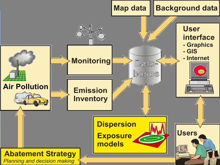
2 An Integrated Air Quality Managament System Monitoring data transfer- models databases GIS platform
3 - GIS-based Air Quality Management Main objectives of the system To enable on-line air quality data presentation Internet To provide complete air pollution exposure information To enable development of cost-effective air pollution abatement strategies System Control options Emissions Measurements Modelling Cost / benefit analysis Best Option: Exposure / Dose Dose Dose / response

4
5 Modules POINT EMISSIONS Exposure Point Sources Dispersion Statistics Line Sources Emission ADACS (Automatic Data Acquisition System) QA/QC Measurement Area Sources Emission Inventory Wind Field Models GIS GUI (graphical user interphase)
6 2003


7 2003 Different modules GIS platform and maps Emission inventories Measurement module Models statistics wind field dispersion exposure
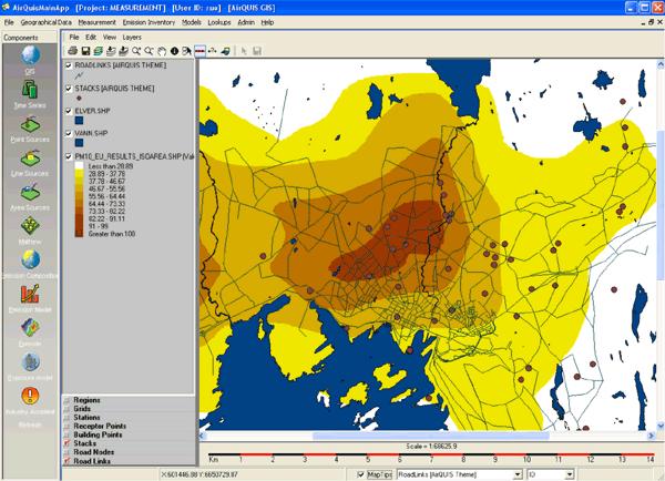
8 Example: GIS functionalities
9 Several data bases On-line collected environmental data Emission and discharge data included emission modelling procedures Historical data and background information Regulations, guideline values Information on the support and decision making process
10 Supporting data base Data base model: historical data background information guidelines & regulations regulations and plans support local and regional levels meet user specifications easily modified open communication solutions
11 Software: Data handling Configuration (names, parameters etc.) Acquisition (display, alarms, overshoots etc.) Files facilities (storage data) For presentation, controls and edit - daily reports - monthly reports (histograms) Calibration operation

12 Measurement Database Stations Instruments Time-series Grab samples Quality Control Automatic Data Acquisition System Manual Data Acquisition System

13 Monitoring station GIS platform
14 Automatic data acquisition system (ADACS) Test data from Yantai, China NO (ppb) NO2 (ppb) NOx (ppb) PM10 (ug/m3) Measurement data are transferred to the computer centre and automatically stored into the AirQUIS database Or: manually imported
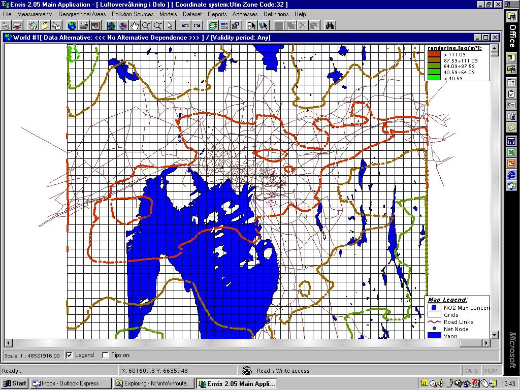
15 For model input Explain AQ data
16 Data Transfer, QA Radio link - telephone - satellite QA at Different Levels: in field: automatic & manual calibration / control data retrieval: QA routines; ISO database: approval and verification final data: statistics, graphics, validity, representativeness.
17 Presentations Statistical and Graphical Presentation Tools Maxima, minima, averages Percentiles Cumulative frequency distribution Wind rose and meteorology frequency distributions User Interface For viewing and editing data in all databases Integrating GIS On-line Internet applications Information to the Public

18 Measurement data statistics


19 Data presentations
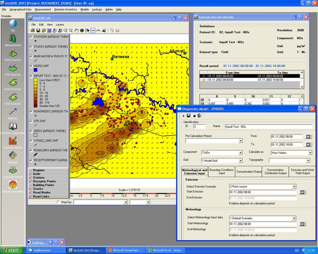
20 AirQUIS Models Emission model Calculates hourly emissions from area, line and point sources. Stores results as field, line or point data set Wind field model (MATHEW) Calculates 3-dimensional hourly wind fields from measurements of wind speed and direction, temperature, gradient and topography Dispersion model (EPISODE) Calculates hourly concentrations of pollutants in grids and individual receptor points Exposure model Combines pollution concentrations with population distribution

21 Inventory of Point Sources
22 The Wind Field Model Meteorological measurements Geographical data Temperature Topography Stability ( T) Wind speed Wind direction Calculation of a mass consistent 3-D wind field

23 Wind Field Model (MATHEW)
24 Dispersion Models


25 Dispersion modelling Spatial distribution of pollutant concentrations Source contribution quantification Effects of suggested measures Exposure Estimates Forecasting
26 NILU models ROADAIR CONCX INPUFF EPISODE for traffic ( km) Gaussian single source (0.1-1 km) puff-trajectory for single sources (1-100 km) for urban areas puff + numerical box (1-50 km)
27 EPISODE Meteorological hourly gridded input data: Windfield (u, v, w) Temperature at ground level Vertical temperature gradient (stability) Mixing height Turbulence ( v and w ) Oslo - 1 km grid
28 Exposure estimate
29 Exposure Assessment Links population data to concentration fields Exposure hours Number of hours a number of people is exposed to pollution over a selected value Person dose Accumulated exposure of pollution over a selected value per person Population Load Accumulated exposure of pollution over a selected value for all persons within a grid square/receptor point
30 Population exposure model A selection of Building Receptor Points is made Only buildings along roads with traffic volume above a certain limit are included

31 Oslo Calculated PM 10 -concentrations 8. highest daily building point value (µg/m 3 )


32 Applications Environment impact assessment A.Q. forecasting and early warning Optimal abatement strategies A.Q. information systems, incl. Online data Internet applications

33 AQ Nowcast and Forecast
 24h")
34 NO 2 (µg/m3) 24h forward
35 Action Plan for Air Quality improvement The Action Plan will identify data and measures necessary to improve the basis for AQMS The Action Plan will concern the following fields: Monitoring /air pollution and meteorology Surveys / emissions inventory Modelling / air quality and exposure Guidelines / Regulations Cost Analysis Air Quality Information System (AQIS)


36 Installations Norway: Oslo Sarpsborg Fredrikstad Drammen Grenland Trondheim Bergen Stavanger Mo i Rana Bilbao, Spain Katowice, Poland Romania Stockholm, Sweden Saudi Arabia China: Yantai Heilongjang Guangzhou Shanxhi (3 cities) National Monitoring Center EU-projects: IRENIE APNEE Oscar ENV-e-City Urban exposure Haifa, Israel Botswana Durban, South Africa HoChiMinh, Vietnam

37 Norwegian Institute for Air Research NILU POBox 100 NO-2027 Kjeller Norway Fax:
38 ENSIS Sensor and monitor development Data logging and quality control Data transfer and processing Statistical and numerical modelling Data presentation using geographical information systems
39 Air Meteorology OL 94 Arenas Forest Water Energy Traffic Industry Sensors Data transfer NIT Database Agriculture Models Presentations Waste GIS

40 ENSIS Air Water Agric. Forest Others Database UNIX Models PC GISsystems User interface Other presentation system Presentations for Users GIS INFO 94
41 EUREKA Lillehammer 94 ENSIS in INFO 94 Lillehammer terminals / accreditated users 30 transactions per hour in each terminal ~ requests for environmental information during the Olympic Games
CAPACITY BUILDING FOR NON-NUCLEAR ATMOSPHERIC TRANSPORT EMERGENCY RESPONSE ACTIVITIES. (Submitted by RSMC-Beijing) Summary and purpose of document
 Summary and purpose of document") WORLD METEOROLOGICAL ORGANIZATION COMMISSION FOR BASIC SYSTEMS OPAG on DPFS Task Team on Development of Operational Procedures for non-nuclear ERA CBS-DPFS/TT-DOP-nNERA/Doc.8 (4.X.2012) Agenda item : 8
WORLD METEOROLOGICAL ORGANIZATION COMMISSION FOR BASIC SYSTEMS OPAG on DPFS Task Team on Development of Operational Procedures for non-nuclear ERA CBS-DPFS/TT-DOP-nNERA/Doc.8 (4.X.2012) Agenda item : 8
Air Quality Models. Meso scale
 Air Quality Models IMMIS IMMIS provides a comprehensive program set to evaluate traffic-induced emission and air pollution. The IMMIS models are integrated in GIS thus retaining the spatial reference in
AN AIR QUALITY MANAGEMENT SYSTEM FOR CYPRUS
 Global NEST Journal, Vol 12, No 1, pp 92-98, 2010 Copyright 2010 Global NEST Printed in Greece. All rights reserved AN AIR QUALITY MANAGEMENT SYSTEM FOR CYPRUS N. MOUSSIOPOULOS 1 1 Laboratory of Heat Transfer
Ensemble based probabilistic forecasting of air quality in Oslo and Rotterdam
 Ensemble based probabilistic forecasting of air quality in Oslo and Rotterdam Sam-Erik Walker, Bruce Rolstad Denby, Núria Castell Balaguer NILU - Norwegian Institute for Air Research 4 th IWAQFR, WMO,
AIRNow and AIRNow-Tech
 AIRNow and AIRNow-Tech Dianne S. Miller and Alan C. Chan Sonoma Technology, Inc. Petaluma, California Presented to the National Tribal Forum Spokane, Washington June 15, 2011 910216-4140 Outline Overview
Instituto de Pesquisas Meteorológicas - IPMet Universidade Estadual Paulista - Unesp
 IPMET WEB GIS APPLICATION FOR SEVERE WEATHER ALERT AND DECISION SUPPORT Jaqueline Murakami Kokitsu Instituto de Pesquisas Meteorológicas - IPMet Universidade Estadual Paulista - Unesp IPMet/Unesp Meteorological
DEVELOPMENT OF A FORECAST EARLY WARNING SYSTEM ethekwini Municipality, Durban, RSA. Clint Chrystal, Natasha Ramdass, Mlondi Hlongwae
 DEVELOPMENT OF A FORECAST EARLY WARNING SYSTEM ethekwini Municipality, Durban, RSA Clint Chrystal, Natasha Ramdass, Mlondi Hlongwae LOCATION DETAILS AND BOUNDARIES ethekwini Municipal Area = 2297 km 2
AREP GAW. AQ Forecasting
 AQ Forecasting What Are We Forecasting Averaging Time (3 of 3) PM10 Daily Maximum Values, 2001 Santiago, Chile (MACAM stations) 300 Level 2 Pre-Emergency Level 1 Alert 200 Air Quality Standard 150 100
A REAL-TIME OPERATIONAL FORECAST MODEL FOR METEOROLOGY AND AIR QUALITY DURING PEAK AIR POLLUTION EPISODES IN OSLO, NORWAY
 A REAL-TIME OPERATIONAL FORECAST MODEL FOR METEOROLOGY AND AIR QUALITY DURING PEAK AIR POLLUTION EPISODES IN OSLO, NORWAY ERIK BERGE 1, SAM-ERIK WALKER 2, ASGEIR SORTEBERG 1,MOTHEI LENKOPANE 2, STEINAR
Integrating air quality information from multiple sources
 Integrating air quality information from multiple sources Joost Wesseling (RIVM) Philipp Schneider (NILU) Why AQ sensors? Citizens/NGO s Local authorities National level Citizen Science has a long history,
IMS4 ARWIS. Airport Runway Weather Information System. Real-time data, forecasts and early warnings
 Airport Runway Weather Information System Real-time data, forecasts and early warnings Airport Runway Weather Information System FEATURES: Detection and prediction of runway conditions Alarms on hazardous
Monitoring Extreme Weather Events. February 8, 2010
 Monitoring Extreme Weather Events February 8, 2010 Extensive network of over 800 stations across the Prairies Good coverage across entire agriculture production region Network of networks strategy includes
New COST Action: Towards a European Network on Chemical Weather Forecasting and Information Systems
 New COST Action: Towards a European Network on Chemical Weather Forecasting and Information Systems Proposer: Mikhail Sofiev Finnish Meteorological Institute Historical background EUMETNET Workshop on
Abstract A statistical method based on adjustments of spatial source oriented structure functions to observed concentration values is presented.
 A stochastic receptor model based on source oriented structure functions K.E. Gr0nskei, S.-E. Walker Norwegian Institute for Air Research, P.O. Box 100, n Airway Abstract A statistical method based on
AIRNow and AIRNow-Tech
 AIRNow and AIRNow-Tech Dianne S. Miller and Alan C. Chan Sonoma Technology, Inc. Petaluma, California Presented to the National Tribal Forum Spokane, Washington June 15, 2011 910216-4140 Outline Overview
Using sensor data and inversion techniques to systematically reduce dispersion model error
 Using sensor data and inversion techniques to systematically reduce dispersion model error D. J. Carruthers 1, A. L. Stidworthy 1, D. Clarke 2, K.J. Dicks 3, R. L. Jones 4,I. Leslie 5, O. A. M. Popoola
GIS-BASED DISASTER WARNING SYSTEM OF LOW TEMPERATURE AND SPARE SUNLIGHT IN GREENHOUSE
 GIS-BASED DISASTER WARNING SYSTEM OF LOW TEMPERATURE AND SPARE SUNLIGHT IN GREENHOUSE 1,2,* 1,2 Ruijiang Wei, Chunqiang Li, Xin Wang 1, 2 1 Hebei Provincial Institute of Meteorology, Shijiazhuang, Hebei
Developments in ADMS-Airport and its Applications to Heathrow Airport. IAE (Institute of Aviation and the Environment) Cambridge, June
 Cambridge, June") Developments in ADMS-Airport and its Applications to Heathrow Airport David Carruthers Cambridge Environmental Research Consultants IAE (Institute of Aviation and the Environment) Cambridge, June 23 28
Developments in ADMS-Airport and its Applications to Heathrow Airport David Carruthers Cambridge Environmental Research Consultants IAE (Institute of Aviation and the Environment) Cambridge, June 23 28
Air quality monitoring reinvented. Helsinki Metropolitan Air Quality Testbed HAQT
 Air quality monitoring reinvented Helsinki Metropolitan Air Quality Testbed HAQT Air Pollution: Single Biggest Environmental Health Risk Inhaling air pollution takes away at least 1-2 years of a typical
Personal Field Data Collection by UM-FieldGIS (Integration of Google Map API to Mobile GIS)
") Personal Field Data Collection by UM-FieldGIS (Integration of Google Map API to Mobile GIS) Ko Ko Lwin*. Yuji MURAYAMA* *Division of Spatial Information Science Graduate School of Life and Environmental
Personal Field Data Collection by UM-FieldGIS (Integration of Google Map API to Mobile GIS) Ko Ko Lwin*. Yuji MURAYAMA* *Division of Spatial Information Science Graduate School of Life and Environmental
Air Quality at Your Street
 Science for the Environment 2015 October 1-2, 20153 Air Quality at Your Street An air quality map for all addresses in Denmark Steen Solvang Jensen, Matthias Ketzel, Jørgen Brandt, Thomas Becker, Morten
AN INTERNATIONAL SOLAR IRRADIANCE DATA INGEST SYSTEM FOR FORECASTING SOLAR POWER AND AGRICULTURAL CROP YIELDS
 AN INTERNATIONAL SOLAR IRRADIANCE DATA INGEST SYSTEM FOR FORECASTING SOLAR POWER AND AGRICULTURAL CROP YIELDS James Hall JHTech PO Box 877 Divide, CO 80814 Email: jameshall@jhtech.com Jeffrey Hall JHTech
NOAA s Air Quality Forecasting Activities. Steve Fine NOAA Air Quality Program
 NOAA s Air Quality Forecasting Activities Steve Fine NOAA Air Quality Program Introduction Planned Capabilities Initial: 1-day 1 forecast guidance for ozone Develop and validate in Northeastern US September,
Intercomparison Exercise of Spatial Representativeness Methods
 Intercomparison Exercise of Spatial Representativeness Methods Kristina Eneroth and Sanna Silvergren SLB-analys Stockholm Health and Environment Administration kristina@slb.nu SLB-analys - our organisation
Developments in operational air quality forecasting at the Met Office
 Developments in operational air quality forecasting at the Met Office Paul Agnew Reading Air Pollution Seminar 9 th July 2009 Met Office air quality modellers Nick Savage, Claire Witham, Carlos Ordonez,
Contribution of Norwegian partners (Aanderaa Data Instruments and NIVA) to Safeport project ( ). Final report
 to Safeport project ( ). Final report") Contribution of Norwegian partners (Aanderaa Data Instruments and NIVA) to Safeport project (2010-2012). Final report NFR-196866 Entry and Berthing Ship and Port Advising System as an Element of Port ITS.
Contribution of Norwegian partners (Aanderaa Data Instruments and NIVA) to Safeport project (2010-2012). Final report NFR-196866 Entry and Berthing Ship and Port Advising System as an Element of Port ITS.
A BASE SYSTEM FOR MICRO TRAFFIC SIMULATION USING THE GEOGRAPHICAL INFORMATION DATABASE
 A BASE SYSTEM FOR MICRO TRAFFIC SIMULATION USING THE GEOGRAPHICAL INFORMATION DATABASE Yan LI Ritsumeikan Asia Pacific University E-mail: yanli@apu.ac.jp 1 INTRODUCTION In the recent years, with the rapid
The GeoCLIM software for gridding & analyzing precipitation & temperature. Tamuka Magadzire, FEWS NET Regional Scientist for Southern Africa
 The GeoCLIM software for gridding & analyzing precipitation & temperature Tamuka Magadzire, FEWS NET Regional Scientist for Southern Africa Outline What is GeoCLIM GeoCLIM Development Team GeoCLIM: objectives
AIRQUEST Annual Report and State of the Model
 AIRQUEST Annual Report and State of the Model Brian Lamb 1, Serena Chung 1, Farren Herron-Thorpe 2 and Joseph Vaughan 1 1 Laboratory for Atmospheric Research, Washington State University, Pullman, W, USA
Swedish Meteorological and Hydrological Institute
 Swedish Meteorological and Hydrological Institute Norrköping, Sweden 1. Summary of highlights HIRLAM at SMHI is run on a CRAY T3E with 272 PEs at the National Supercomputer Centre (NSC) organised together
STANDARD OPERATING PROCEDURES
 PAGE: 1 of 5 CONTENTS 1.0 SCOPE AND APPLICATION 2.0 METHOD SUMMARY 3.0 SAMPLE PRESERVATION, CONTAINERS, HANDLING, AND STORAGE 4.0 INTERFERENCE AND POTENTIAL PROBLEMS 5.0 EQUIPMENT/APPARATUS 6.0 REAGENTS
Abstract. 1 Introduction
 Urban air pollution forecast based on the Gaussian and regression models M. Zickus', K. Kvietkus^ ' Vilnius University, Sauletekio 9, 2600 Vilnius, Lithuania * Institute of Physics, A. Gostauto 12, 2600
CLIMATE CHANGE ADAPTATION BY MEANS OF PUBLIC PRIVATE PARTNERSHIP TO ESTABLISH EARLY WARNING SYSTEM
 CLIMATE CHANGE ADAPTATION BY MEANS OF PUBLIC PRIVATE PARTNERSHIP TO ESTABLISH EARLY WARNING SYSTEM By: Dr Mamadou Lamine BAH, National Director Direction Nationale de la Meteorologie (DNM), Guinea President,
1 Introduction. Station Type No. Synoptic/GTS 17 Principal 172 Ordinary 546 Precipitation
 Use of Automatic Weather Stations in Ethiopia Dula Shanko National Meteorological Agency(NMA), Addis Ababa, Ethiopia Phone: +251116639662, Mob +251911208024 Fax +251116625292, Email: Du_shanko@yahoo.com
Site audit report Birkenes, Norway
 Site audit report Birkenes, Norway Dr. Thomas Tuch, WCCAP World Calibration Centre for Aerosol Physics (WCCAP), Leibniz Institute for Tropospheric Research, Leipzig, Germany Summary: Measurements of physical
Know and Respond AQ Alert Service. Paul Willis SCOTTISH AIR QUALITY DATABASE AND WEBSITE ANNUAL SEMINAR Stirling 30 th March 2011
 Know and Respond AQ Alert Service Paul Willis SCOTTISH AIR QUALITY DATABASE AND WEBSITE ANNUAL SEMINAR Stirling 30 th March 2011 Outline: Know and Respond AQ Alert Service Introduction. The Website. How
INSPIRE in the context of EC Directive 2002/49/EC on Environmental Noise
 INSPIRE in the context of EC Directive 2002/49/EC on Environmental Noise Simon Shilton Acustica Ltd, United Kingdom Nigel Jones Extrium Ltd, United Kingdom About the Authors www.acustica.co.uk Acoustics
THE METEOROLOGICAL DATA QUALITY MANAGEMENT OF THE ROMANIAN NATIONAL SURFACE OBSERVATION NETWORK
 THE METEOROLOGICAL DATA QUALITY MANAGEMENT OF THE ROMANIAN NATIONAL SURFACE OBSERVATION NETWORK Ioan Ralita, Ancuta Manea, Doina Banciu National Meteorological Administration, Romania Ionel Dragomirescu
I&CLC2000 in support to new policy initiatives (INSPIRE, GMES,..)
") I&CLC2000 in support to new policy initiatives (INSPIRE, GMES,..) Manfred Grasserbauer, Director Joint Research Centre Institute for Environment and Sustainability 1 IMAGE 2000 European mosaic of satellite
I&CLC2000 in support to new policy initiatives (INSPIRE, GMES,..) Manfred Grasserbauer, Director Joint Research Centre Institute for Environment and Sustainability 1 IMAGE 2000 European mosaic of satellite
Data fusion techniques for real-time mapping of urban air quality
 ESA eo open science 2.0 12-14 October 2015, Frascati, Italy Making sense of crowdsourced observations: Data fusion techniques for real-time mapping of urban air quality Philipp Schneider 1 Nuria Castell
Moroccan lightning detection network, topology, performance and management of the network
 Moroccan lightning detection network, topology, performance and management of the network Mohamed DAHOUI, Mohamed NBOU and Rabia MERROUCHI Moroccan Meteorological Center Tel (212)71302837, Fax: (212)22908593
Steve Pietersen Office Telephone No
 Steve Pietersen Steve.Pieterson@durban.gov.za Office Telephone No. 031 311 8655 Overview Why geography matters The power of GIS EWS GIS water stats EWS GIS sanitation stats How to build a GIS system EWS
1.21 SENSITIVITY OF LONG-TERM CTM SIMULATIONS TO METEOROLOGICAL INPUT
 1.21 SENSITIVITY OF LONG-TERM CTM SIMULATIONS TO METEOROLOGICAL INPUT Enrico Minguzzi 1 Marco Bedogni 2, Claudio Carnevale 3, and Guido Pirovano 4 1 Hydrometeorological Service of Emilia Romagna (SIM),
Primary author: Tymvios, Filippos (CMS - Cyprus Meteorological Service, Dpt. of Aeronautical Meteorology),
,") Primary author: Tymvios, Filippos (CMS - Cyprus Meteorological Service, Dpt. of Aeronautical Meteorology), ftymvios@ms.moa.gov.cy Co-author: Marios Theophilou (Cyprus Meteorological Service, Climatology
Primary author: Tymvios, Filippos (CMS - Cyprus Meteorological Service, Dpt. of Aeronautical Meteorology), ftymvios@ms.moa.gov.cy Co-author: Marios Theophilou (Cyprus Meteorological Service, Climatology
Series homogenization, missing data filling and gridded products with Climatol
 Series homogenization, missing data filling and gridded products with Climatol José A. Guijarro State Meteorological Agency (AEMET), Balearic Islands Office, Spain 11 th EUMETNET Data Management Workshop
Air quality real-time operational forecasting system for Europe: an application of the MM5-CMAQ-EMIMO modelling system
 Air Pollution XIV 75 Air quality real-time operational forecasting system for Europe: an application of the MM5-CMAQ-EMIMO modelling system R. San José 1, J. L. Pérez 1 & R. M. González 2 1 Environmental
EUMETSAT. A global operational satellite agency at the heart of Europe. Presentation for the Spanish Industry Day Madrid, 15 March 2012
 EUMETSAT A global operational satellite agency at the heart of Europe Presentation for the Spanish Industry Day Madrid, Angiolo Rolli EUMETSAT Director of Administration EUMETSAT objectives The primary
USE OF SATELLITE INFORMATION IN THE HUNGARIAN NOWCASTING SYSTEM
 USE OF SATELLITE INFORMATION IN THE HUNGARIAN NOWCASTING SYSTEM Mária Putsay, Zsófia Kocsis and Ildikó Szenyán Hungarian Meteorological Service, Kitaibel Pál u. 1, H-1024, Budapest, Hungary Abstract The
A Hybrid ARIMA and Neural Network Model to Forecast Particulate. Matter Concentration in Changsha, China
 A Hybrid ARIMA and Neural Network Model to Forecast Particulate Matter Concentration in Changsha, China Guangxing He 1, Qihong Deng 2* 1 School of Energy Science and Engineering, Central South University,
Let's Make Our Cities Breathable BECAUSE CLEAN AIR BELONGS TO EVERYONE.
 Let's Make Our Cities Breathable BECAUSE CLEAN AIR BELONGS TO EVERYONE. Clean Air is a Human Right that Everyone Should be Entitled to Making cities more breathable starts by measuring, analyzing and understanding
List of Exposure and Dose Metrics
 List of Exposure and Dose Metrics First approved by the TOAR Steering Committee on July 31, 2015, and revised on June 27, 2016 to add two additional metrics. Following is the list of exposure and dose
QualiMET 2.0. The new Quality Control System of Deutscher Wetterdienst
 QualiMET 2.0 The new Quality Control System of Deutscher Wetterdienst Reinhard Spengler Deutscher Wetterdienst Department Observing Networks and Data Quality Assurance of Meteorological Data Michendorfer
Solar Radiation and Solar Programs. Training Consulting Engineering Publications GSES P/L
 Solar Radiation and Solar Programs Training Consulting Engineering Publications SOLAR RADIATION Purposes of Solar Radiation Software Successful project planning and solar plant implementation starts by
Texas A & M University and U.S. Bureau of Reclamation Hydrologic Modeling Inventory Model Description Form
 Texas A & M University and U.S. Bureau of Reclamation Hydrologic Modeling Inventory Model Description Form JUNE, 1999 Name of Model: Two-Dimensional Alluvial River and Floodplain Model (MIKE21 CHD & CST)
A VALIDATION EXERCISE ON THE SAFE-AIR VIEW SOFTWARE. Joint Research Centre NDFM Ispra, Italy 2
 A VALIDATION EXERCISE ON THE SAFE-AIR VIEW SOFTWARE F. D Alberti 1, F. d Amati 1, E. Canepa 2, G. Triacchini 3 1 Joint Research Centre NDFM Ispra, Italy 2 CNR INFM CNISM Department of Physics, University
Air Quality Simulation of Traffic Related Emissions: Application of Fine-Scaled Dispersion Modelling
 Air Quality Simulation of Traffic Related Emissions: Application of Fine-Scaled Dispersion Modelling M. Shekarrizfard, M. Hatzopoulou Dep. of Civil Engineering and Applied Mechanics, McGill University
Pascal ET is an handheld multifunction calibrator for the measurement and simulation of the following parameters: - pressure
 DATASHEET Pascal ET Pascal ET is an handheld multifunction calibrator for the measurement and simulation of the following parameters: - pressure - electrical signals (ma, mv, V, ) - temperature (TC and
Introduction to GIS I
 Introduction to GIS Introduction How to answer geographical questions such as follows: What is the population of a particular city? What are the characteristics of the soils in a particular land parcel?
a system for input, storage, manipulation, and output of geographic information. GIS combines software with hardware,
 Introduction to GIS Dr. Pranjit Kr. Sarma Assistant Professor Department of Geography Mangaldi College Mobile: +91 94357 04398 What is a GIS a system for input, storage, manipulation, and output of geographic
Winter weather and municipal winter road maintenance
 Winter weather and municipal winter road maintenance Marie Eriksson 1 and Alf Johansson 2 1 Marie Eriksson, PhD, Klimator AB, Earth Sciences Centre, Box 460, SE-405 30 Göteborg, SWEDEN. E-mail: mariee@gvc.gu.se,
Open Source ENKI: Dynamic Environmental Model Framework. A possible pre-processor for WRF-Hydro?
 Open Source ENKI: Dynamic Environmental Model Framework A possible pre-processor for WRF-Hydro? 1st European Fully Coupled AtmosphericHydrological Modeling and WRF-Hydro Users workshop. University of Calabria.
Wind Resource Assessment Practical Guidance for Developing A Successful Wind Project
 December 11, 2012 Wind Resource Assessment Practical Guidance for Developing A Successful Wind Project Michael C Brower, PhD Chief Technical Officer Presented at: What We Do AWS Truepower partners with
Syllabus Reminders. Geographic Information Systems. Components of GIS. Lecture 1 Outline. Lecture 1 Introduction to Geographic Information Systems
 Syllabus Reminders Geographic Information s Lecture Introduction to Geographic Information s. Class Info: www.saigis.com/class/ 2. Office T / TH (8:00-9:30 a.m.) and (2:30 3:30pm) or Appt 3. Email: burgerpr@unk.edu
Application and verification of the ECMWF products Report 2007
 Application and verification of the ECMWF products Report 2007 National Meteorological Administration Romania 1. Summary of major highlights The medium range forecast activity within the National Meteorological
A COMPREHENSIVE WORLDWIDE WEB-BASED WEATHER RADAR DATABASE
 A COMPREHENSIVE WORLDWIDE WEB-BASED WEATHER RADAR DATABASE Oguzhan SİRECİ 1, Paul JOE 2, Serkan EMINOGLU 3, Kamuran AKYILDIZ 4 1 Turkish State Meteorological Service(TSMS), Kecioren, Ankara Turkey,osireci@gmail.com
Bloomsburg University Weather Viewer Quick Start Guide. Software Version 1.2 Date 4/7/2014
 Bloomsburg University Weather Viewer Quick Start Guide Software Version 1.2 Date 4/7/2014 Program Background / Objectives: The Bloomsburg Weather Viewer is a weather visualization program that is designed
CWMS Modeling for Real-Time Water Management
 Hydrologic Engineering Center Training Course on CWMS Modeling for Real-Time Water Management August 2018 Davis, California The Corps Water Management System (CWMS) is a software and hardware system to
Generating and Using Meteorological Data in AERMOD
 Generating and Using Meteorological Data in AERMOD June 26, 2012 Prepared by: George J. Schewe, CCM, QEP BREEZE Software 12770 Merit Drive Suite 900 Dallas, TX 75251 +1 (972) 661-8881 breeze-software.com
Air Quality Modelling for Health Impacts Studies
 Air Quality Modelling for Health Impacts Studies Paul Agnew RSS Conference September 2014 Met Office Air Quality and Composition team Paul Agnew Lucy Davis Carlos Ordonez Nick Savage Marie Tilbee April
Watershed Application of WEPP and Geospatial Interfaces. Dennis C. Flanagan
 Watershed Application of WEPP and Geospatial Interfaces Dennis C. Flanagan Research Agricultural Engineer USDA-Agricultural Research Service Adjunct Professor Purdue Univ., Dept. of Agric. & Biol. Eng.
Regional services and best use for boundary conditions
 Regional services and best use for boundary conditions MACC-III User Workshop Roma, 11 May 2015 Virginie Marécal (Météo-France) Laurence Rouïl (INERIS) and the MACC regional consortium Regional services
LAYMAN S REPORT Floods and Fire Risk Assessment and Management
 LAYMAN S REPORT Floods and Fire Risk Assessment and Management FLIRE is 50% co-financed by LIFE + financial instrument of the European Union. Floods and Fire risk assessment and management Project s code
PC ARC/INFO and Data Automation Kit GIS Tools for Your PC
 ESRI PC ARC/INFO and Data Automation Kit GIS Tools for Your PC PC ARC/INFO High-quality digitizing and data entry Powerful topology building Cartographic design and query Spatial database query and analysis
A Case Study of Sulfur Dioxide in Muscatine, Iowa and the Ability for AERMOD to Predict NAAQS Violations
 A Case Study of Sulfur Dioxide in Muscatine, Iowa and the Ability for AERMOD to Predict NAAQS Violations Presented by Charlene Becka Air Quality Engineer NAAQS SO 2 Standards Respiratory irritant in sensitive
MODELING FOR ENVIRONMENTAL RADIATION DOSE RECONSTRUCTION. Bruce Napier 23 May 2011
 MODELING FOR ENVIRONMENTAL RADIATION DOSE RECONSTRUCTION Bruce Napier 23 May 2011 1 Topics NCRP Report No. 163 Atmospheric dispersion modeling Reconstruction of dose from releases of iodines and noble
The Vaisala AUTOSONDE AS41 OPERATIONAL EFFICIENCY AND RELIABILITY TO A TOTALLY NEW LEVEL.
 The Vaisala AUTOSONDE AS41 OPERATIONAL EFFICIENCY AND RELIABILITY TO A TOTALLY NEW LEVEL. Weather Data Benefit For Society The four most important things about weather prediction are quality, reliability,
National Report on Weather Forecasting Service
 MINISTRY OF WATER RESOURCES AND METEOROLOGY DEPARTMENT OF METEOROLOGY, CAMBODIA National Report on Weather Forecasting Service Tokyo, 11-15 March 2014 Department of Meteorology, Cambodia Presentation Outline
Understanding Geographic Information System GIS
 Understanding Geographic Information System GIS What do we know about GIS? G eographic I nformation Maps Data S ystem Computerized What do we know about maps? Types of Maps (Familiar Examples) Street Maps
What is GIS? Introduction to data. Introduction to data modeling
 What is GIS? Introduction to data Introduction to data modeling 2 A GIS is similar, layering mapped information in a computer to help us view our world as a system A Geographic Information System is a
Comprehensive Winter Maintenance Management System BORRMA-web MDSS inside to increase Road Safety and Traffic Flow
 Thorsten Cypra 1 Comprehensive Winter Maintenance Management System BORRMA-web MDSS inside to increase Road Safety and Traffic Flow American Public Works Association (APWA) Monday, 04/14/2008 3:30 4:30
Model-Driven Migration of Scientific Legacy Systems to Service-Oriented Architectures
 Model-Driven Migration of Scientific Legacy Systems to Service-Oriented Architectures Presentation at Model-Driven Software Migration (MDSM) 2011, Oldenburg, Germany, March 1 st 2011 Jon Oldevik (SINTEF
Validation of a present weather observation method for driving rain. mapping
 Validation of a present weather observation method for driving rain mapping James P. Rydock a,b a Department of Civil and Transport Engineering, Norwegian University of Science and Technology (NTNU), Høgskoleringen
Weather Company Energy and Power Products
 IBM Terms of Use SaaS Specific Offering Terms Weather Company Energy and Power Products The Terms of Use ( ToU ) is composed of this IBM Terms of Use - SaaS Specific Offering Terms ( SaaS Specific Offering
Weather Company Energy and Power Products
 Service Weather Company Energy and Power Products This Service (SD) describes the Cloud Service IBM provides to Client. Client means the company and its authorized users and recipients of the Cloud Service.
The WMO Integrated Global Observing System (WIGOS), current status and planned regional activities
, current status and planned regional activities") The WMO Integrated Global Observing System (WIGOS), current status and planned regional activities Dr. Lars Peter Riishojgaard WMO Secretariat, Geneva Outline Introduction to WIGOS WMO The Rolling Review
The WMO Integrated Global Observing System (WIGOS), current status and planned regional activities Dr. Lars Peter Riishojgaard WMO Secretariat, Geneva Outline Introduction to WIGOS WMO The Rolling Review
Causes of high PM 10 values measured in Denmark in 2006
 Causes of high PM 1 values measured in Denmark in 26 Peter Wåhlin and Finn Palmgren Department of Atmospheric Environment National Environmental Research Institute Århus University Denmark Prepared 2 October
Dispersion Modeling of the Transport and Dispersion of SO 2 Pollutants Emitted from a Power Plant in Tong Liang
 Final Report for the Project Dispersion Modeling of the Transport and Dispersion of SO 2 Pollutants Emitted from a Power Plant in Tong Liang Contractors: Dr. Darko Koracin, Dr. John Watson, 1. Executive
AMMS-100 Atmospheric Metal Monitoring System
 AMMS-100 Atmospheric Metal Monitoring System USEPA Method IO-. compliant Measure 28 toxic metals simultaneously Magnitude of detection limit 0.01-0.1ng/m Associate measurements with time of day or meteorological
THE 3D SIMULATION INFORMATION SYSTEM FOR ASSESSING THE FLOODING LOST IN KEELUNG RIVER BASIN
 THE 3D SIMULATION INFORMATION SYSTEM FOR ASSESSING THE FLOODING LOST IN KEELUNG RIVER BASIN Kuo-Chung Wen *, Tsung-Hsing Huang ** * Associate Professor, Chinese Culture University, Taipei **Master, Chinese
MUDMAP TM. Software Description
 ASA Applied Science Associates, Inc. 70 Dean Knauss Drive Narragansett, RI 02882-1143 U.S.A. Tel: 401-789-6224 Fax: 401-789-1932 asa@asascience.com www.asascience.com MUDMAP TM Software Description MUDMAP
Gridded Ambient Air Pollutant Concentrations for Southern California, User Notes authored by Beau MacDonald, 11/28/2017
 Gridded Ambient Air Pollutant Concentrations for Southern California, 1995-2014 User Notes authored by Beau, 11/28/2017 METADATA: Each raster file contains data for one pollutant (NO2, O3, PM2.5, and PM10)
Calculates CAT and MWT diagnostics. Paired down choice of diagnostics (reduce diagnostic redundancy) Statically weighted for all forecast hours
 Statically weighted for all forecast hours") 1 Major Upgrades All diagnostics mapped to Eddy Dissipation Rate ADDS now displays EDR values CAT diagnostic extended down to 1000 feet MSL & forecast hours 15 and 18 New Mountain Wave diagnostic CAT diagnostics
1 Major Upgrades All diagnostics mapped to Eddy Dissipation Rate ADDS now displays EDR values CAT diagnostic extended down to 1000 feet MSL & forecast hours 15 and 18 New Mountain Wave diagnostic CAT diagnostics
Transactions on Information and Communications Technologies vol 18, 1998 WIT Press, ISSN
 GIS in the process of road design N.C. Babic, D. Rebolj & L. Hanzic Civil Engineering Informatics Center, University ofmaribor, Faculty of Civil Engineering, Smetanova 17, 2000 Maribor, Slovenia. E-mail:
MODERNIZATION OF THE MUNICIPAL MAPPING USING HIGH END GNSS SYSTEM AND GIS SOFTWARE
 MODERNIZATION OF THE MUNICIPAL MAPPING USING HIGH END GNSS SYSTEM AND GIS SOFTWARE Mr. R. A. R. Khan Assistant Engineer, Sewerage Utility Management Centre (SUMC) Municipal Corporation Of Greater Mumbai
Outline Project overview Suite description Input data Results 2D fields Results time series Final remarks EMEP4HR. Institute, Croatia
 EMEP4HR Lukša Kraljević 1, Danijel Belušić 3, Zvjezdana Bencetić Klaić 3, Ana Bennedictow 2, Hilde Fagerli 2, Branko Grisogono 3, Amela Jeričević 1, Domagoj Mihajlović 1, Kornelija Špoler Čanić1, Leonor
Overview of U.S. Forecasting/Outreach Methods
 Overview of U.S. Forecasting/Outreach Methods John E. White, US EPA white.johne@epa.gov NCAR/ASP 2016 Summer Colloquium on Air Quality Outline Air Quality Forecasting in the U.S. How it is done Challenges
Role of Meteorology on Urban Air Pollution Dispersion: A 20yr Analysis for Delhi, India
 Simple Interactive Models for Better Air Quality Role of Meteorology on Urban Air Pollution Dispersion: A 20yr Analysis for Delhi, India Dr. Sarath Guttikunda January, 2010 Delhi, India SIM-air Working
Numerical simulation of the low visibility event at the. Hong Kong International Airport on 25 December 2009
 Numerical simulation of the low visibility event at the Hong Kong International Airport on 25 December 2009 P. W. Chan, Hong Kong Observatory, Hong Kong, China; and T. Yao and J. C. H. Fung, Hong Kong
Supplementary Appendix
 Supplementary Appendix This appendix has been provided by the authors to give readers additional information about their work. Supplement to: Downs SH, Schindler C, Liu L-JS, et al. Reduced exposure to
Urban Canopy Tool User Guide `bo`
 Urban Canopy Tool User Guide `bo` ADMS Urban Canopy Tool User Guide Version 2.0 June 2014 Cambridge Environmental Research Consultants Ltd. 3, King s Parade Cambridge CB2 1SJ UK Telephone: +44 (0)1223