All Hazards Mitigation Plan
|
|
|
- Jacob Alexander
- 5 years ago
- Views:
Transcription

1 B-C-K-P Regional Intergovernmental Council All Hazards Mitigation Plan 1
2 Introduction and Background Information. 3 Documentation of Planning Process.13 Risk Assessment Hazard Identification. 16 Profile of Priority Hazards.20 Dam Failure Drought.25 Earthquake.28 Flooding.31 Landslides/mudslides/Land Subsidence 58 Severe Storms 62 Tornadoes..64 Wildfire.65 Vulnerability Assessment..68 Identifying Structures. 68 Estimating Losses..75 Analyze Development Trends...78 Multi-Jurisdictional Risk and Vulnerability Assessment..79 Mitigation Strategy 81 Mitigation Goals 81 Mitigation Actions and Strategies. 82 Multi-Jurisdictional Actions and Strategies..95 Implementation of National Flood Insurance Program (NFIP) 96 Implementation of Mitigation Actions.98 Plan Maintenance Process Appendix A Plan Development Process Documentation Appendix B Adoption Documentation Appendix C HAZUS Reports Appendix D Critical Facilities Maps 2
3 Introduction and Background Information: This plan was developed in accordance with Part of Section 322 of the Robert T. Stafford Disaster Relief and Emergency Assistance Act, as enacted by Section 104 of the Disaster Mitigation Act of Under the current guidelines of the Hazard Mitigation Grant Program and the pre Disaster Mitigation Program administered by the Federal Emergency Management Agency, the B-C-K-P Regional Intergovernmental Council is required to create a Regional Hazard Mitigation Plan. By combining the 4 county mitigation plans developed by Boone County, Clay County, Kanawha County and Putnam County, the B-C-K-P Regional Intergovernmental Council will be able to qualify for grant funding. The purpose of a Hazard Mitigation Plan for the B-C-K-P Regional Intergovernmental Council is to identify ways to reduce the effects of natural hazards on the land, environment and citizens, and determine actions to be taken to reduce the risk of people and property to all disasters. Possible projects and suggestions from the individual county plans will also be included. Several resources were used during the development of the plan, including the US Department of Homeland Security s Federal Emergency Management Agency (FEMA) Mitigation Planning How-To series, each county s own Hazard Mitigation Plan, the governing regulations in the Code of Federal Regulations (CFR), and documents provided by the WV Division of Homeland Security and Emergency Management, West Virginia Department of Natural Resources, National Oceanic and Atmospheric Administration, and the National Climactic Data Center. B-C-K-P Regional Intergovernmental Council The B-C-K-P Regional Intergovernmental Council (hereafter referred to as RIC in this document) was formed in 1968 and comprised of locally elected municipal and county officials in Boone, Clay, Kanawha and Putnam counties. The initial goal of RIC was to address regional issues and promote intergovernmental cooperation. In 1971 the West Virginia Legislature enacted the West Virginia Regional Planning and Development Act. This divided the state into eleven regions, each serving as a development district for its respective counties. The goal of the act is to effectively utilize and organize the State s resources and to maximize the opportunities for local communities and public service agencies to secure Federal assistance for economic development, water and sewer systems, and other public projects. Currently RIC is structured as a locally oriented public corporation. It is directed by elected municipal and county officials from within its jurisdiction, as well as non-elected appointees from a cross-section of the region s social and economic institutions. RIC s policy board consists of 45 members, including one commissioner from each of the four counties, the mayor of each of the 25 municipalities, fourteen citizen representatives, and two minority representatives. (RIC 2009 Annual Report) 3
4 RIC is comprised of Boone, Clay, Kanawha and Putnam counties, each with their own different characteristics. Boone and Clay are rural counties with little urban development and many coal operations. Kanawha and Putnam hold most of the development and therefore the majority of population and employment from the region. Part of RIC s four county area falls in the Kanawha River Valley with the Appalachian Mountains nearby. The Kanawha River flows through Kanawha and Putnam counties. The Elk River flows through Clay County and joins the Kanawha River in Charleston. The Big Coal River flows through Boone County and joins the Kanawha River in St. Albans. This waterway system combined with the Appalachian Mountains creates an area of deep valleys and steep slopes. The valleys and mountain slopes do increase the risk of flooding, dam failure and other minor hazards related to flooding. However, the mountains protect the area from tornadoes and other extremely high winds. The distance from the ocean greatly lessens the risk of damage by hurricane. Also RIC does not lie on any fault lines, so major earthquakes are not likely. Three interstate highways meet in Charleston. I-64 travels east and west. I-77 travels directly north and south, while I-79 starts in Charleston and follows a north east direction. Several U.S. Highways and state highways are utilized by travelers in Region 3; U.S. 35, U.S. 60, U.S. 119, WV 34 and WV 25. The following table describes the population, population density and precipitation amounts in RIC s four county area. Population Households Area Pop. Density Rainfall Snowfall Avg Temp Elevation Boone 25, , Clay 10, , Kanawha 200, , Putnam 51, , RIC 287, , ,
5 5
6 Boone County Boone County is a rural county in southern West Virginia about 15 miles south of Charleston, the state capital. It has four municipalities; Madison, the county seat, and the Towns of Danville, Whitesville and Sylvester. As the population grew along the waterways so did a lot of the counties infrastructure. Most of the counties roads and utilities follow along the same path, increasing exposure to natural hazards. The 2000 Census lists Boone County as having a total population of 25,535. Boone County s temperature is varied but has an average of 54 degrees Fahrenheit with four distinct season changes. The average elevation is 820 feet above sea level. Boone County has a total area of 503 square miles. Boone County s economy relies strongly on coal production. Coal mining has been the main stay of the area for over 100 years. Most of the largest employers in the county are coal producers or transporters. Over 90% of the land area in the county is woodland. The timber industry has been growing in the county for the past several years bringing along with it those businesses that service i.e. trucking and sawmills. Tourism is another industry that has grown in this area due to hunting, fishing, the addition of the Hatfield and McCoy Trail system and the creation of the National Coal Miners memorial. 6
7 7
8 Clay County Clay County is located in the South-central part of West Virginia. Clay County s temperature is varied but has an average of 54 degrees Fahrenheit with four distinct season changes. The average elevation is 805 feet above sea level. Clay County has a total area of 344 square miles. Population is 10,330 according to the 2000 census. Clay County s only municipality is the Town of Clay located in the central part of the county. Leading industries are lumber, coal and natural gas. 8
9 9
10 Kanawha County Kanawha County is located in south-western West Virginia. Kanawha County s temperature is varied but has an average of 55 degrees Fahrenheit with four distinct season changes. The average elevation is 692 feet above sea level. Kanawha County has a total area of 911 square miles. Kanawha County contains 14 municipalities: Belle, Cedar Grove, Charleston, Chesapeake, Clendenin, Dunbar, East Bank, Glasgow, Handley, Marmet, Nitro, Pratt, St. Albans, and South Charleston. According to the 2000 Census, Kanawha County s population is 200,073. The population density is 222 people per square mile with and average household size of There are five locations of industrial and business development in the Charleston-Kanawha County area. These locations provide room for various companies who seek to expand their market in West Virginia and surrounding states. Peerless Industrial Park, Fork of Coal Industrial Park, South Charleston Technology Park, NorthGate Business Park and Washington Heights Business Park are all located within easy access to various transportation methods. 10
11 11
12 Putnam County Putnam County is located in the Central Western section of the state. Putnam County s temperature is varied but has an average of 55 degrees Fahrenheit with four distinct season changes. The average elevation is 591 feet above sea level. Putnam County has a total area of 350 square miles. The total population of Putnam County is 51,589 from the 2000 Census. There are seven incorporated municipalities within the county; Bancroft, Buffalo, Eleanor, Hurricane, Nitro, Poca and Winfield. Putnam County has several industrial parks and many retail shopping centers. Because of Putnam County s close proximity to Charleston and Huntington, many people travel to those large cities for employment. 12
13 13
14 Documentation of Planning Process In August 2009 FEMA conducted a Planning and Project Management Workshop for the Regional Planning and Development Councils in West Virginia. This workshop detailed the Hazard Mitigation planning process, FEMA grant programs and how to generate projects for mitigation. Following the FEMA sponsored workshop work began to combine Boone, Clay, Kanawha, and Putnam Counties plans into a Regional Hazard Mitigation Plan. From individual plans to now, all jurisdictions still participate. Because this was originally thought of as simply a combination of each county s plan a formal steering committee was not formed. Each individual county plan was thoroughly examined for hazards, risks, goals, and projects. Each section of each county s Hazard Mitigation Plan (Boone County Multi- Jurisdictional Hazard Mitigation Plan, Clay County Hazard Mitigation Plan, Kanawha County Multi-Jurisdictional Hazard Mitigation Plan, and Putnam County All-Hazards Mitigation Plan) was reviewed, analyzed and revised as part of this regionalization effort. When questions regarding a specific element in a county plan arose the appropriate representative was contacted. A risk assessment was performed on all hazards represented in the individual county plans. Hazard profiles were created based upon the risk relative to the entire area. The recently updated West Virginia State Hazard Mitigation Plan was consulted for a complete list of hazards. An inventory of assets and loss estimation were performed by gleaning information from the county plans, Geographic Information Systems (GIS) data, NCDC Data, and HAZUS reports. A mitigation strategy was developed by combining each county s goals, objectives, and projects. Goals were summarized for a uniform regional perspective, but each county s specific goals, objectives and projects are listed in Appendix D. Eventually a Draft B-C-K-P Regional Intergovernmental Council All-Hazards Mitigation Plan was formed. The next task was to involve each municipality and county representative and encourage response. An initial was sent to all members of the RIC directing them to view the draft plan online or in office and return an attached questionnaire. We also encouraged them to participate in an online survey. Public Announcements were published in the four county areas and draft plans were available online and in the RIC office in South Charleston. Kara Greathouse addressed the RIC members at a quarterly meeting on Thursday May 13 th 2010, and has had the sole responsibility of combining the four county hazard mitigation plans into one regional plan. This communication and involvement effort resulted in 3 returned comments, two in the form of the questionnaire and one online survey response. All documentation and responses can be found in Appendix A. Members of the public and especially the RIC board, who we feel are comprised of our primary stakeholders, have been contacted multiple times and asked for input. There has been a lack of response, but it is not unexpected for this area. There has been no effort to include neighboring communities as 14
15 it is assumed they are participating in the regionalization of their Hazard Mitigation Plan. The entire state of West Virginia is under going this process at the same time. Other agencies, businesses etc. have had the same opportunity as the general public to participate in this plan update. As this is the first Hazard Mitigation Plan for Region 3 it is likely more effort will be placed upon this in future updates. Responses were considered and incorporated into the plan and a Final B-C-K-P Regional Intergovernmental Council All-Hazards Mitigation Plan was completed and distributed to FEMA for initial approval. Pending FEMA approval each municipality and county will receive a digital or hard copy for adoption. Adoption Documentation is provided in Appendix B. 15
16 Risk Assessment Risk Assessment is the process of measuring the potential loss of life, personal injury, and economic and property damage resulting from natural or man-made hazards. The result of this assessment helps to identify and understand the risks involved. This information also serves as the foundation for the development of the mitigation plan and strategies to help reduce risks from future hazard events. The purpose of this risk assessment is to identify the hazards that have caused or possess the potential to cause hazardous situations and the loss of property and life in Boone, Clay, Kanawha and Putnam Counties. The information in this assessment will allow us to identify the events that are most likely to occur and have the greatest. Hazard Identification: Several methods of research were utilized to identify the hazards to which Region 3 is susceptible. Several related plans and historical data were used to compile a list of potential hazards and their risk. Boone County Multi-Jurisdictional Hazard Mitigation Plan, Boone County Commission, 2005 Clay County Hazard Mitigation Plan, Clay County Commission, 2003 Kanawha County Multi-Jurisdictional Hazard Mitigation Plan, Kanawha County Commission, 2009 Putnam County All-Hazards Mitigation Plan, Putnam County Commission, 2008 Kanawha County All Hazards Mitigation Manual, Kanawha County Commission, The following chart lists the hazards previously analyzed in individual county plans. The chart ranks each hazard based upon ranking from individual plans and the state plan. RIC s individual vulnerability was considered and each hazard will be further researched and analyzed in this document. Hazard Priority Reason Dam Failure med/high There are 57 dams in Boone, Clay, Kanawha, and Putnam counties, several dams are coal related, at capacity or near capacity. USACE 16
17 Drought Earthquake Extreme Heat Flooding Hazardous Material Hurricane Land Subsidence, Karst Topography, Expansive Soils, Landslides, or Mudslides Nuclear Accident Severe Storms (thunderstorms, Lightning, and hailstorms) Tornadoes/High Winds Wildfire Winter Storms med/low low low high med/low low medium low med/high med/low med high There have been three periods of Severe or Extreme Drought throughout the entire state of West Virginia. The USGS rates RIC as having a 8% Peak Ground Acceleration in Temperatures in RIC rarely exceed 100 degrees Fahrenheit and periods of over 100 degree weather do not last long. Extreme heat will be further discussed under the Drought Hazard Profile. All counties in RIC have experienced flooding to varying degrees and contain development within the 100 year flood plains. West Virginia has experienced 21 Hazardous Material Incidents in 2009 and 3 have been classified as serious incidents. Out of 21 incidents 19 occurred on the highway system. RIC is at least 400 miles from the Atlantic Ocean, coastal events are unlikely to effect this area. Hurricanes cause severe storms in this area, please see 'Severe Storms.' USGS classifies most of West Virginia and all of RIC as being at a high risk for land slides owing to the steep mountainous slopes. However there have been very few landslides reported in RIC. If a landslide were to occur it would be in the more remote or uninhabited areas of Region 3. It is important to note that there is no Karst Topography in any of RIC s four counties, this greatly lowers the risk of land subsidence or landslides. This hazard was profiled and analyzed in the West Virginia State Hazard Mitigation Plan, but was not ranked. Based upon the analysis in the state plan and the closest nuclear reactor being over 200 miles away a nuclear accident is unlikely to affect the RIC counties. Most flooding occurs after severe storms or heavy rain events; while these events do not always cause major damage the after effects often cause major damage. Because of the terrain and topography of RIC, tornadoes are unlikely; however there have been 6 reported tornadoes in the area in the past 50 years. High Winds are likely to occur with severe storms or winter storms and cause minor damage. RIC includes forested areas so wildfire is likely to occur, but the history of wildfires in the region is very small. RIC occasionally experiences periods of heavy snow, ice storms, extreme cold temperatures or other blizzard conditions. There have been disasters declared in the past 17
18 due to winter storms so the risk in Boone, Clay, Kanawha, and Putnam counties is high. See also, severe storms. The following table lists all the hazards analyzed in this plan and their corresponding definition. Hazard Dam Failure Drought Earthquake Flooding Landslides / Land Subsidence Severe Storms Definition A dam is defined as a barrier constructed across a waterway for the purpose of storage, control or diversion of water. Dams provide water for drinking, navigation, agricultural irrigation, hydroelectric power, recreational opportunities, waste impoundment and, perhaps most importantly in West Virginia, flood protection. Drought is a prolonged period of dry weather that causes serious problems to crops or water supply. The severity of the drought depends upon the degree of moisture deficiency, the duration, and the size of the affected area. An earthquake is a sudden rapid shaking of the Earth caused by the breaking and shifting of rock beneath the Earth s surface FEMA defines flooding as the accumulation of water within a water body and the overflow of excess water onto adjacent floodplain lands. A landslide is characterized by the downward and outward movement of slope forming materials reacting under the force of gravity. The term landslide includes mudflows, mudslides, debris flows, rock falls, rockslides, debris avalanches, debris slides, and earth flows. Landslides are mostly caused by extreme rainfall, excavation, construction or new development, underground mining, Karst topography, rock fall, extraction of natural gases, or seasonal effects. Land subsidence is vertical earth movement resulting from increased stresses in the soil mass, or loss of shallow soil support. Subsidence can be described as rapid, caused by undermining or failure of the underlying strata, or slow, caused by consolidation. Severe storms can encompass many different types of storms; severe thunderstorms, lightning, winter storms, wind storms and hail storms. Severe storms typically 18
19 Tornadoes Wildfire involve heavy or long periods of rain, snow and/or hail. A tornado appears as a rotating, funnel-shaped cloud that extends from a storm cloud to the ground with whirling winds that can reach 300 miles per hour. Damage paths can be as large as one mile wide and 50 miles long. A wildfire is an uncontrolled fire that occurs in a forested area. A wildfire differs from other fires by its extensive size, the speed at which it can spread out from its original source, and its ability to change direction unexpectedly and to jump gaps, such as roads, rivers and fire breaks. A non-wilderness structural fire occurs in an urban area and primarily accrues structural damage. Urban fires are instances where uncontrolled burning occurs in residential and commercial development areas. 19
20 Profile of Priority Hazards: Dam Failure A dam is defined as a barrier constructed across a waterway for the purpose of storage, control or diversion of water. Dams provide water for drinking, navigation, agricultural irrigation, hydroelectric power, recreational opportunities, waste impoundment and, perhaps most importantly in West Virginia, flood protection. A dam failure is the collapse, breach or other failure resulting in downstream flooding. Dams can pose a risk to communities if not designed, constructed, operated, and maintained properly. In the event of a catastrophic dam failure, the energy the water released from even a small dam is capable of causing extensive property damage, injury and potential loss of life. This is especially true in West Virginia where many communities lie in steep, narrow valleys. A dam failure is a rare occurrence, but can cause great damages and loss of human life. Dams regulated by the state and federal authorities are classified by their potential impacts on downstream life and property. Class 1 (High Hazard) dams are located where a failure may cause loss of life or major damage to buildings and lifelines such as highways, roads, and bridges. Class 2 (Significant hazard) dams are located where a failure may cause minor damage to structures downstream, and is unlikely to result in loss of life. Classes 3 and 4 represent dams with lower or no potential for downstream damage. The WVDEP currently regulates 310 Class 1 and 2 dams in West Virginia. Dam owners in West Virginia include the National Resources Conservation Service (47 %), other federal government bodies (7%), the state (12 %), local government (10%), private individuals or corporations (15 percent), and unknown owners (9%). The landowners generally do not operate the dams. The approximately 150 NRCS flood control dams (of Dam Safety Act jurisdictional size) are operated and maintained by a sponsor agency such as a soil conservation district, county, or WVDNR. These sponsor agencies are organized under an umbrella agency to represent their interests in the legislature and help develop monitoring and emergency action plans. The umbrella agency is the West Virginia Conservation Agency (WVCA). (Long, 2007) There are 57 dams in RIC s four county area ranked as a significant or high hazard and owned by state and federal entities; fourteen are categorized as a significant hazard while 43 are considered a high hazard. The table below breaks down the total number of dams by county and hazard. Significant High Hazard Total Dams Hazard Boone Clay
21 Kanawha Putnam Region Dams with a significant hazard potential would result in no loss of human life, but cause economic loss, environmental damage or disruption of lifeline facilities if a failure occurred. Significant hazard potential dams are often located in mostly rural or agricultural areas. Dams with a high hazard potential would result in the loss of one or more human lives. The dam owner may choose to produce an Emergency Action Plan (EAP) to reduce the potential for property damage and loss of life if the dam were to fail. RIC has 57 dams total and only eight dams have an Emergency Action Plan. The WVDEP DWWM Dam Safety Program has regulatory jurisdiction over dams in the State of West Virginia, and performs inspections of dams as necessary to enforce the provisions of the West Virginia Dam Control and Safety Act. The following table describes recorded dam incidents within the past 100 years. Date Dam Location Deaths Damages Cause Description August 9, 1916 August 9, 1916 August 9, 1916 Unnamed Unnamed Unnamed Between Acme & Kayford, WV (Kanawha County) Jarrolds Valley, Boone Co, WV Cabin Creek Valley, WV (Kanawha County) from flood (unknown if related to failure) from flood (unknown if related to failure) Inflow flood Inflow flood from flood (unknown if >$600,000 Inflow flood related to failure) Extensive damage; especially to rail, telephone, and coal company History of Dam Failure There are no comprehensive databases of historical dam failure in West Virginia. Most failures occur due to lack of maintenance of facilities in combination with major precipitations events, such as hurricanes and thunderstorms. There have been no significant incidents of dam failures at coal combustion waste impoundments. Boone County, in the past, has experienced breakthroughs, seepage or failures of coal slurry impoundments. Coal slurry impoundments are considered a higher risk due to the 21
22 close proximity of people and structures. According to the West Virginia Division of Culture and History, Buffalo Creek hollow was flooded in February of 1972 due to negligent strip mining and heavy rain. After the surge of coal slurry 118 were dead and 4000 were left homeless. This disaster led to stricter regulations regarding mining dam construction and future maintenance. Since then there have been no dam failures. However, there have been several breakthroughs, where slurry from an impoundment enters the nearby streams and rivers through the mine. This causes great environmental damage but so far no losses of life. Coal slurry impoundment failures will cause damages similar to a 100 year flood. The Bluestone Dam spans the New River at Hinton, WV forming Bluestone Lake. Bluestone Dam was constructed as part of the Kanawha River Basin flood control system primarily to reduce major flood damages along the New, Kanawha, Ohio, and Mississippi Rivers. Bluestone Dam was completed for operational purposes in January As of January 2009 Bluestone Dam has prevented over 2.1 billion dollars worth of flood damage from occurring. Bluestone Dam has the largest drainage area, 4,565 square miles, of any dam in West Virginia. Recently concerns have been expressed about the possible failure of the Bluestone Dam. A stabilization project began in 1998, and is projected to be completed by At the end of the project the Bluestone Dam will have over 500 additional anchors installed to ensure the stability of the structure. The anchors will be drilled through the dam into the bedrock to keep the dam from sliding. After the project is completed the Dam will be able to withstand a 5,000 year flood event. Vulnerability and Impact Assessment: Predicting the probability of a dam failure requires a detailed, site-specific engineering analysis for each dam in question. Failure may result from hydrologic and hydraulic design limitations, or from geotechnical or operational factors. The data and time necessary to perform a probabilistic failure analysis for each dam in West Virginia is beyond the scope of this plan. Vulnerability to dam failure is dependent on dam operations planning and the nature of downstream development. Depending on the elevation and storage volume of the impoundment, the impact of dam failure may include loss of human life, economic losses such as property damage and infrastructure disruption, and environmental impacts such as destruction of habitat. Evaluation of vulnerability and impact is highly dependent on site-specific conditions. Risk Assessment Dams of greatest concern for failure are those included on a list of deficient dams maintained by the WVDEP DWWM Dam Safety Program. A deficient dam is defined as a structure that exhibits one or more design or maintenance problems that may adversely affect the performance of the dam during a major storm, or over time, that represents a potential for loss of life or property. However, the degree of hazard within this definition can vary greatly. The dams in West Virginia are rated based on a variety of factors, including the storm capacity of the dam, spillway condition, safety, embankment 22
23 condition, reservoir volume, height, downstream population, proximity to population, highway traffic, and posted speed. The scores for each of these variables are added to determine the priority rank order for deficient dams. The following table provides a list of deficient dams with a priority ranking. There are 38 deficient dams in West Virginia, two are in Putnam County and one is in Kanawha County. (WVDEP DWWM, 2004). Deficient Dams in Boone, Clay, Kanawha and Putnam Counties Priority Rank Name of Dam ID Downstream Town/County 3 Lake Washington Dam Hurricane/Putnam 18 Hurricane WS Dam Winfield/Putnam 23 Poffenbarger # 1 Dam Cross Lanes/Kanawha Source: WVDEP DWWM, 2004 The following map shows the location of all known dams in the RIC four county area and their classification. Refer to the third paragraph under the Dam Failure hazard profile for the classification definitions. 23
24 24
25 Drought Drought is a prolonged period of dry weather that causes serious problems to crops or water supply. The severity of the drought depends upon the degree of moisture deficiency, the duration, and the size of the affected area. Droughts are predictable by careful monitoring of meteorological and hydrological variables. Meteorologists study precipitation patterns, soil moisture and stream flow using various indices to show deficits in precipitation over periods of time. There are four methods to define the severity of drought: meteorological, hydrological, agricultural, and socioeconomic. Meteorological drought refers to a reduction in the normal rainfall for a given geographic area. This needs to be area-specific, as the average rainfall can vary greatly in different areas. Hydrological drought is based on the amount of surface and groundwater relative to normal levels. Agricultural drought deals with the amount of moisture in soils available for plants. The last, socioeconomic drought, measures the impact that any or all of the first three have on people and businesses. Perhaps the simplest and most consistent measure is meteorological drought. An existing index called the Palmer Drought Severity Index measures a departure from the normal rainfall in a given area. Palmer Drought Severity Index Severity Index Value Extreme Drought -4 or less Severe Drought -4 to -3 Moderate Drought -3 to 2 Mild Drought -2 to 1 Incipient Dry Spell -1 to 0.5 Current drought conditions in West Virginia and the nation are tracked by the U.S. Drought Monitor, a partnership between the University of Nebraska-Lincoln, as well as various federal and state agencies and other experts. Graphical and text summaries of current and projected drought conditions are updated on a weekly basis and are available through: The Palmer Index is most effective in determining long term drought, and uses temperature and rainfall information in a formula to determine dryness. Palmer Drought Severity Index measures the duration and intensity of a drought. Below are two maps showing the Palmer Drought Index for meteorological and hydrological conditions in November An animated copy of this map can be found on the National Oceanic and Atmospheric Administration s (NOAA) website. The animated version shows the geographical pattern of the long term moisture conditions for the entire year of RIC is shown in white on both maps; this indicates a normal pattern of moisture for November 25
26 2009. If the animated maps are viewed, RIC is depicted as having a normal pattern of moisture throughout

27 History of Droughts There have been 43 recorded droughts in Region 3 since Boone County has reported 10 droughts, Clay County has reported 9 droughts, Kanawha County has reported 12 droughts, and Putnam County has reported 12 droughts. No crop damages were reported, but it is likely that each county suffered from crop loss due to drought. Most damages that incur costs from droughts are damages to crops and wildfire prevention. Deaths directly caused by a drought are rare. It is difficult to calculate the amount of crop loss that occurred during a drought; therefore it will not be included in the risk assessment. Impact and Vulnerability Assessment Short-term droughts can impact agricultural productivity, while longer term droughts are more likely to impact not only agriculture, but also water supply. Jurisdictions that have invested in water supply and distribution infrastructure are generally less vulnerable to drought. Short and long-term drought may lead to an increase in the incidence of wildfires which might in turn lead to increased potential for landslides or mudflows once rain does fall. 27
28 Risk Assessment Risk from drought has not been formally quantified, due to the difficulty in assessing its frequency and a lack of data detailing its impact. The severity of the drought depends upon the degree of moisture deficiency, the duration, and the size of the affected area. Throughout 2009 RIC has had a normal pattern of moisture. Drought is likely to occur in the future, damage costs are low and each county is equally vulnerable. Crops and livestock would be damaged most by a drought. From the limited data regarding previous drought events that is available through NCDC Storm Events, it is apparent that drought has taken a considerable toll on the crops in the past. No deaths, injuries or property damage (other than crops) appear in the NCDC dataset. Earthquake An earthquake is a sudden rapid shaking of the Earth caused by the breaking and shifting of rock beneath the Earth s surface. Most earthquakes east of the Rockies occur when two slides of a fault slip past each other, or a new slip is created on an existing fault. Small faults exist more frequently than big faults and therefore more small earthquakes than big. The size of an earthquake is measured by magnitude and intensity. Most earthquakes in West Virginia are too small to be felt or cause damage. Very few earthquakes have occurred in West Virginia. Occasionally earthquakes will cause tremors in areas of West Virginia, but little damage results. The West Virginia Geological and Economic Survey provided a Geologic Map of West Virginia. By looking at West Virginia s geologic map you can see no visible fault lines, they are usually designated by black lines on geologic maps. However, there may be faults that are buried beneath the soil; this is common in states east of the Rocky Mountains. 28

29 29
30 History of Earthquakes To date, there have been no Federal Declared Disasters or NCDC recorded events for earthquakes in the RIC four county area. An active earthquake region in Giles County, Virginia has recorded many earthquakes over the years. Occasionally tremors will be felt in West Virginia, sometimes in Boone, Clay, Kanawha, or Putnam counties. Damage is usually limited to cracked plaster, items fallen off shelves or broken windows. West Virginia in general has a moderate risk of seismic activity; however the potential damage from this seismic activity is relatively low compared to states with more dense populations and more tall buildings. From 1887 through 1974, only a handful of earthquakes were detected in and around the state. The strongest earthquake experienced by West Virginia occurred on November 19, More significant damage was sustained during the Giles County, Virginia earthquakes of 1897 and During these two events, residents reported damage to chimneys. Vulnerability, Impact and Risk Assessment Most earthquakes in West Virginia are too small to be felt or cause damage. Very few earthquakes have occurred in West Virginia. Occasionally earthquakes will cause tremors in areas of West Virginia, but little damage results. The southern portion of Kanawha 30
31 County and all of Boone County are more vulnerable to earthquakes than the rest of the study area. The United States Geologic Survey designed the above Seismic Hazard Map. Most of Region 3 is located in a 6 8% peak acceleration area. The probability of an earthquake occurring within the next 50 years is high, but the damage we would be likely to see is negligible. Since fault lines are unknown throughout all of West Virginia, the same general risk for the entire RIC area will be assumed. Annualized loss was computed, in HAZUS, by multiplying losses from eight potential ground motions by their respective annual frequencies of occurrence, and then summing the values. The following table shows the HAZUS results for the probabilistic annualized loss run by county. Kanawha County has the highest annualized loss due to earthquake. Boone $153,024 Clay $75,806 Kanawha $722,629 Putnam $254,898 RIC Total $1,206,357 Flooding: FEMA defines flooding as the accumulation of water within a water body and the overflow of excess water onto adjacent floodplain lands. The floodplain is the land adjoining the channel of a river, stream, ocean, lake, or other watercourse or water body that is susceptible to flooding. Flooding can be separated into several types: riverine flooding including over flow from a river channel, flash floods, alluvial fan floods, and ice-jam floods; riverine flooding including dam-break floods; local drainage or high groundwater levels; fluctuating lake levels; coastal flooding, including storm surges and tsunamis; debris flows; and subsidence. Flooding is the most common environmental hazard in Region 3 due to the topography and location of development and water systems in the region. Flooding generally occurs during a flash flood, a large amount of precipitation in a short period of time, or a general flood, a prolonged period of precipitation. Flash floods occur within a few minutes or a few hours from large amounts of rainfall over a water way. Flash floods characteristically involve fast moving water that can destroy bridges, homes, roadways, landscaping and even cause mudslides or landslides. General flooding occurs over a longer period of time combining rainfall and runoff volumes from slopes adjacent to streams and rivers. General flooding usually occurs within the floodplain, low lying areas next to rivers, streams or creeks. Floodplains are divided into different zones based upon the different levels of flooding experienced in a 31
32 certain amount of time. A 100 year flood will most likely cover the 100-year zone of the land next to the water body, and will have a one percent chance of occurring during a year. A 500-year flood is more damaging, but will be less likely to occur, a 0.2 percent chance in a year. Floodplain maps delineating the floodplain zones are developed by the National Flood Insurance Program. These easy to decipher maps enable viewers to see if a structure falls within a floodplain and therefore justify participation in the National Flood Insurance Program. The National Flood Insurance Program made floodplain maps from certain counties available in a GIS format. Clay, Kanawha and Putnam counties are all available, Boone County will soon be able to view digital formats of their floodplain maps. History of Flooding Boone County Boone County has experienced 22 floods between May 1996 and These flood events incurred $ million in property damages and resulted in 5 deaths. The two most notable floods in this time period occurred in Whitesville. In July 2001 a flash flood incurred three million dollars in property damage. In April 2007 a general flood caused $750,000 in property damage. Clay County Clay County has experienced 17 floods between May 1996 and These flood events incurred $37.07 million in property damages and resulted in 4 deaths. In June 1998, the most notable flood occurred in the Bomont area, property damage was in excess of $150,000. Disaster assistance was also received in May 2001 from flooding in Nebo, property damage was estimated at $20,000. Kanawha County Kanawha County has experienced 41 floods between May 1996 and These flood events incurred $ million in property damages and resulted in 1 injury and 11 deaths. In June 1998 a costly flood occurred in Sissonville resulting in five million dollars of property damage. In June 2003 another notable flood occurred in the Pocatalico area (close to Sissonville) resulting in seven million dollars in property damage. Putnam County Putnam County has experienced 29 floods between May 1996 and These flood events incurred $ million in property damages and resulted in 1 injury and 5 deaths. The southern portion of Putnam County is more prone to flooding than then northern half. Deaths Injuries Property Damage Boone M Clay M Kanawha M Putnam M Region M 32
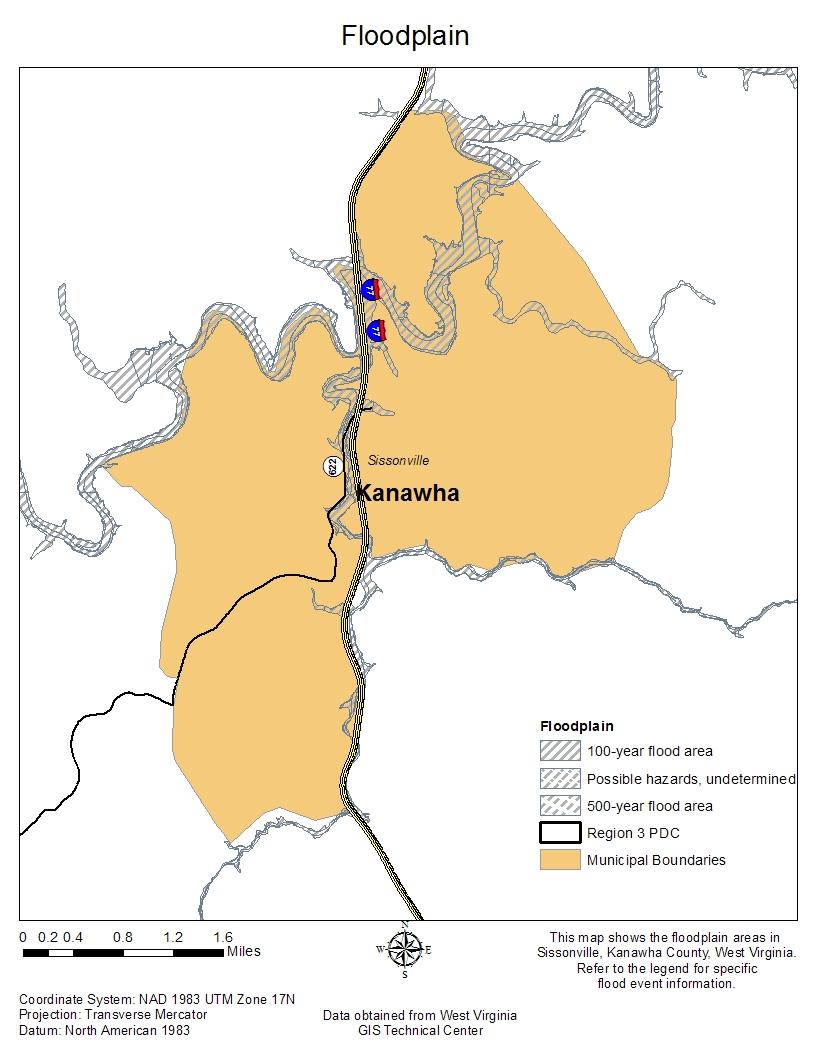
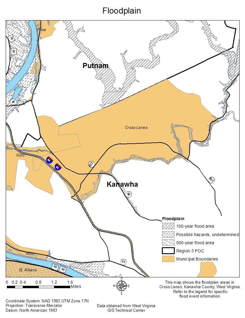
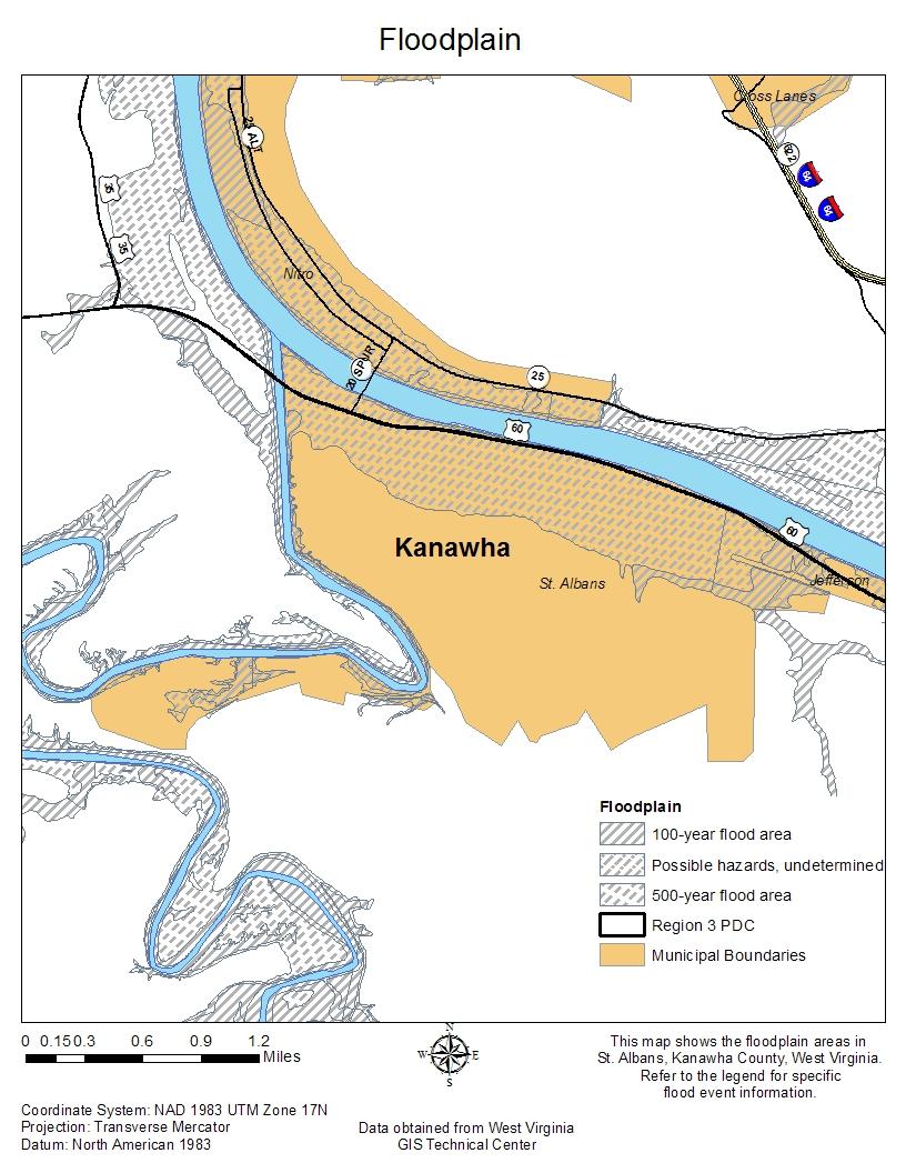
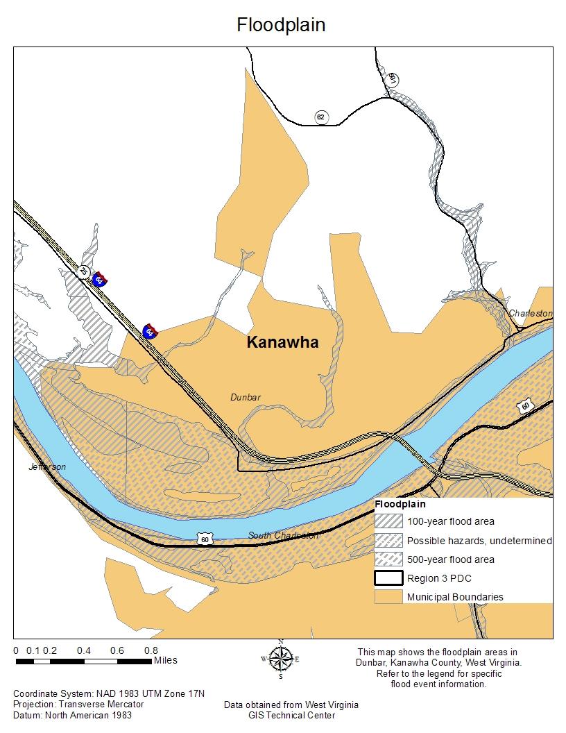
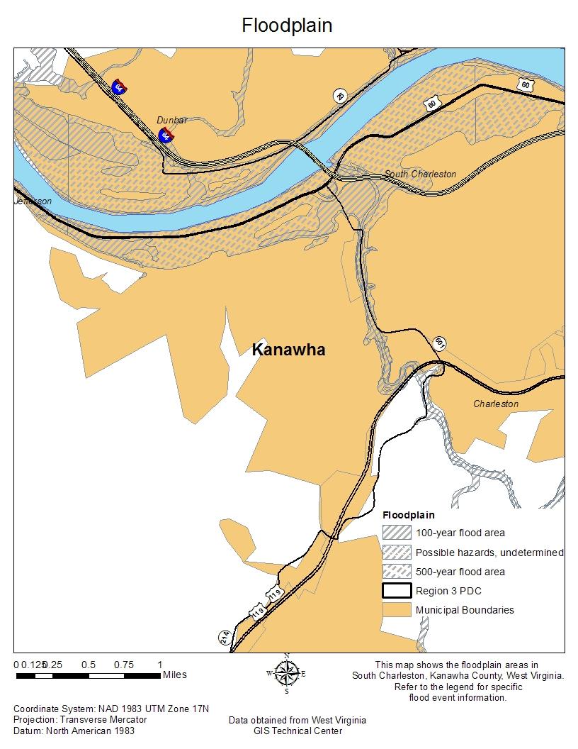
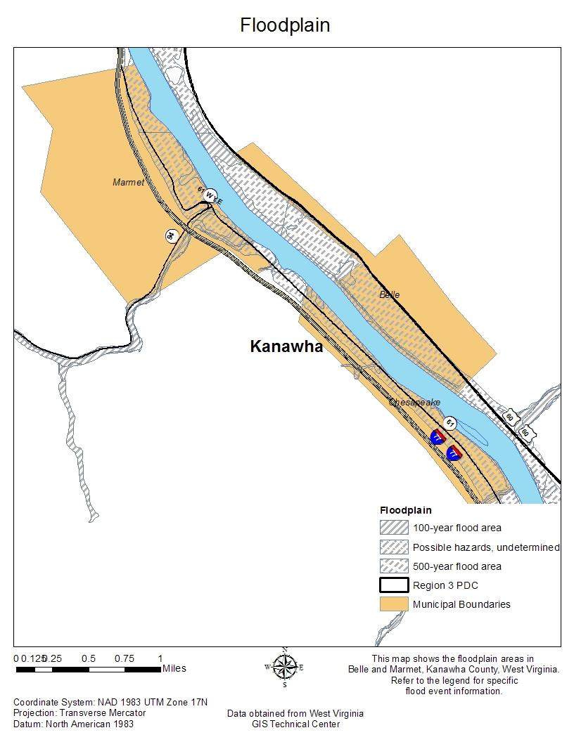
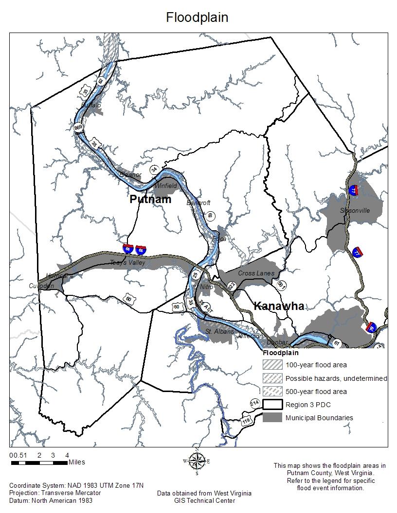
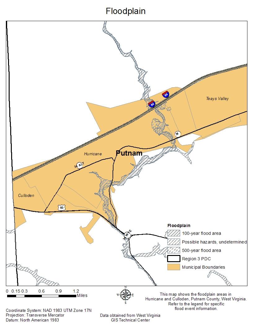
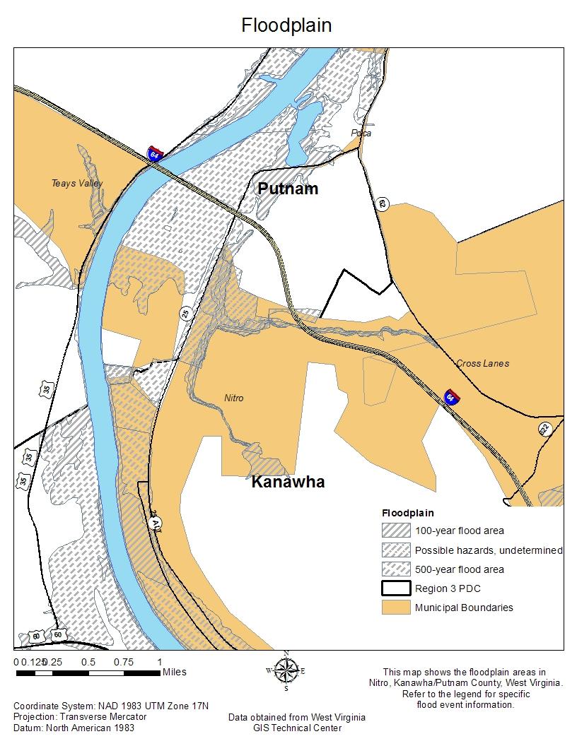
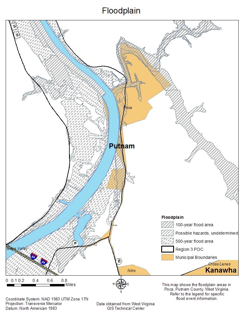
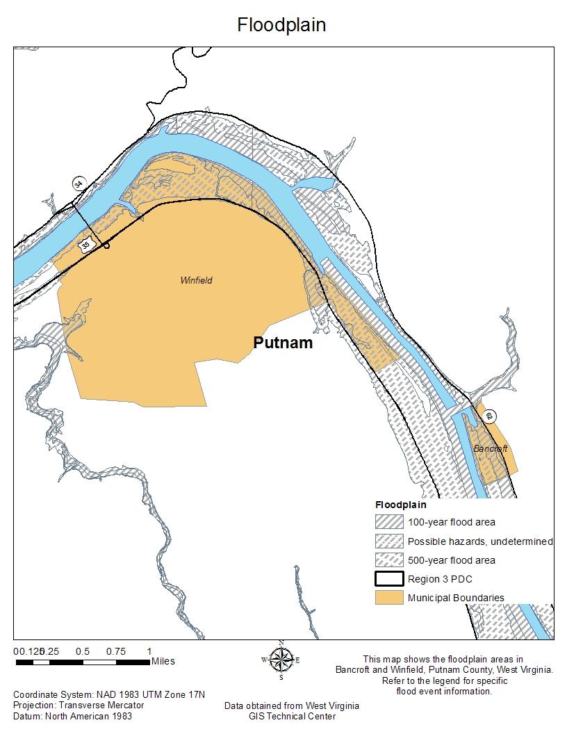
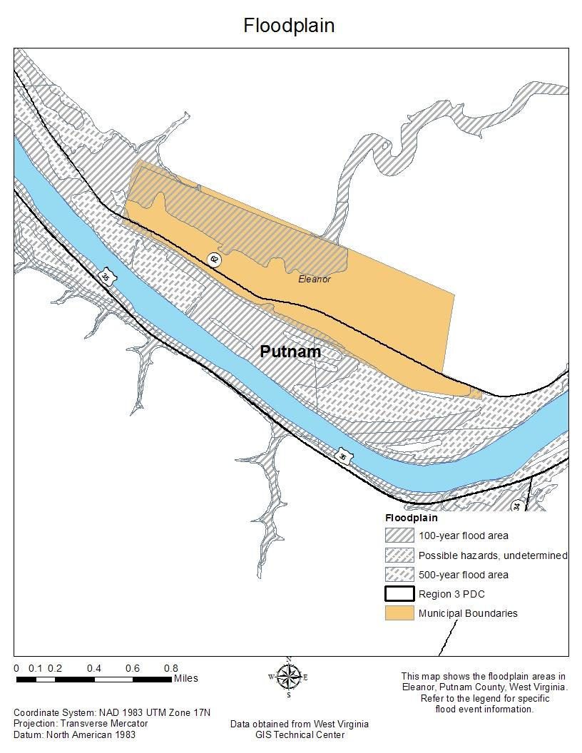
33 Vulnerability and Impact Assessment: Flooding is likely to occur in the future and more likely to occur in the floodplain. Flooding is frequent in all four counties and creates a large mess. Mud, mildew and poor drinking water are just a few things to combat after flood waters recede. A map below shows the floodplain for Clay, Kanawha, and Putnam counties and municipalities. Land area located in the 100 year flood plain has a 1% annual chance of flooding. Land area located in the 500 year flood plain has a 0.2% annual chance of flooding. Data in the map below is taken from the FEMA Flood Insurance Rate Maps (FIRMs) and has not been completed for Boone County. 33
34 34
35 35
36 36
37 37
38 38
39 39
40 40

41 41
42 42
43 43

44 44
45 45
46 46
47 47
48 48

49 49
50 50

51 51
52 52
53 53
54 54
55 55
56 56
57 57
58 Risk Assessment Flooding in West Virginia is quite common, as a general rule future development within a floodplain without proper precaution should be discouraged. A critical facility should not be located in a floodplain if at all possible. If a critical facility must be located in a floodplain it should be provided a higher level of protection so that it can continue to function and provide services after the flood. Typical critical facilities include hospitals, fire stations, police stations, and similar facilities. Critical functions should also be broadened to consider things like storage of critical records in flood-prone basements. Communities should develop emergency plans to continue to provide these services during the flood. Repetitive Loss Properties that have incurred two losses within 10 years of at least $1,000 paid under the National Flood Insurance Program are defined as Repetitive Loss Properties. Severe Repetitive Loss properties are residential properties that have made four or more claims resulting in $5,000 or more in losses. Kanawha County has seven severe repetitive loss properties, and Boone County has two. Participation in the Severe Repetitive Loss Program requires flood insurance, and can provide assistance in acquisition, elevation or mitigation of the Severe Repetitive Loss properties. More information can be found in the section titled Participation in the National Flood Insurance Program. Landslides/mudslides/Land Subsidence A landslide is characterized by the downward and outward movement of slope forming materials reacting under the force of gravity. The term landslide includes mudflows, mudslides, debris flows, rock falls, rockslides, debris avalanches, debris slides, and earth flows. The type of movement and type of material in motion generally classifies the landslides. Types of movement include: rotational, translational, block, falls, topples, debris flows, debris avalanche, earth flow, creep and lateral spreads. The types of materials in motion generally consist of fractured or weathered bedrock and loose or unconsolidated soils. A combination of two or more of the principle flow types is referred to as a complex movement. Land subsidence is changes in the surface elevation from underground changes of the soil structure. Landslides are mostly caused by extreme rainfall, excavation, construction or new development, underground mining, Karst topography, rock fall, extraction of natural gases, or seasonal effects. Land subsidence is vertical earth movement resulting from increased stresses in the soil mass, or loss of shallow soil support. Subsidence can be described as rapid, caused by undermining or failure of the underlying strata, or slow, caused by consolidation. Rapid subsidence, generally referred to as sinkholes, result from small subsurface voids enlarging over time until the thickness of soil/rock at the roof is 58
59 insufficient to support the applied loads, including its own weight. Rapid subsidence frequently occurs in areas of abandoned mines, and karst areas underlain by carbonate rocks (limestone and dolomite) Karst is a landscape with topographic depressions caused by the dissolution of carbonate rocks (limestone and dolomite) by moving groundwater. Karst topography develops throughout the United States, but is not widely found in Boone, Clay, Kanawha or Putnam Counties. History of Landslides As the map below shows, West Virginia is at a very high risk for landslides. While the risk is high, it is very hard to predict when and where a landslide could occur. Most landslides in RIC have occurred around abandoned mine lands. These areas are prone to landslides because the underground soil structure has been greatly altered. However, these areas are often in uninhabited areas, so very low damage costs are incurred. Kanawha and Putnam counties would be at risk of landslides with a cause of excavation due to new development or construction. No historic record of landslides in West Virginia was found so it is unknown how many or what circumstances landslides have caused in Boone, Clay, Kanawha and Putnam Counties. Vulnerability and Impact Assessment Landslides occur in all 50 states and U.S. territories, and cause $3.5 billion in damages and between 25 and 50 fatalities each year (2005, USGS). Expansion of urban and recreational developments into hillside areas leads to more people that are threatened by landslides each year. Landslides commonly occur in connection with other major natural disasters such as earthquakes, volcanoes, wildfires, and floods, and are sometimes more damaging than the initial natural disaster. The probability of subsidence cannot be expressed in terms of a specific return period as easily as it can for other hazards. Risk Assessment West Virginia is at a high risk for landslides. While the risk is high, it is very hard to predict when and where a landslide could occur. Most landslides in RIC have occurred around abandoned mine lands, however, these areas are often in uninhabited areas, so very low damage costs are incurred. Kanawha and Putnam counties would be at risk of landslides with a cause of excavation due to new development or construction. 59


60 Landslide potential of the conterminous United States: Red areas have very high potential, yellow areas have high potential, and green areas have moderate potential. Landslides can and do occur in the black areas, but the potential is low. Map not to scale. Sources: the National Atlas and the USGS The map below will show abandoned mine lands in Boone, Clay, Kanawha and Putnam counties. These areas are at a higher risk of a landslide than the rest of the county area. 60
61 61
62 Severe Storms Severe storms can encompass many different types of storms; severe thunderstorms, lightning, winter storms, wind storms and hail storms. While severe storms occur frequently they rarely cause costly damages. Region 3 is at high risk throughout the year to various types of severe storms. A thunderstorm is formed from a combination of moisture, rapidly rising warm air and a force capable of lifting air such as a warm or cold front, or a sea or lake-breeze. All thunderstorms contain lightning. Damage from severe thunderstorms often occurs when a single thunderstorm affects one location for an extended time. Thunderstorms can contribute to an onslaught of other hazards, such as flooding, strong straight-line winds, tornadoes, hail, and lightning, as well as the possibility of lightning initiated fires. Downburst winds, typically associated with thunderstorms, are straight-line winds that are distinguishable from tornado activity by pattern of destruction and debris. Depending on the size, intensity, and location of these events, the destruction to property may be devastating. Downburst winds generally fall into two categories; microburst, an area less than 2.5 miles in diameter, macroburst, an area at least 2.5 miles in diameter. Thunderstorms and wind storms are declared when winds reach 58 miles per hour. Severe wind gusts cause damage to power lines and trees; tree limbs or even whole trees fall down and damage power lines or block roadways. Loss of power causes a loss of business and additional work to repair the failed utilities. Also, blocked roadways will cause additional work to repair and clean up any debris or fallen limbs. Since 2000 Region 3 has incurred $1.2 million in damages due to high winds. Hailstorms cause damage to crops, structure, transportation systems and personal property. Hailstorms are more common in elevated areas like the mountainous areas of Region 3. Hail rarely causes enough damage to close a business or keep employees from reporting to work. Since 2000 Region 3 has reported many storms with hail ranging from 0.75 inches to 2.5 inches. Winter storms may pose the most risk to human life due to the freezing temperatures, dangerous driving conditions and utility failures. Winter storms can include blizzards, heavy snowstorms and ice storms. A blizzard is classified by having 35 mile per hour winds and heavy snowfall. Heavy snowstorms are declared when four inches or more snow falls in a twelve hour period. An ice storm involves rain and below freezing temperatures. All three types of winter storms can cause utility failures, road closures and falling trees and tree limbs. February 16th, 2003 marked a winter storm that encompassed all of Region 3 and several other West Virginia Counties and cost $1.9 million in damages. This was the largest and most costly winter storm during our study period of 2000 to November
63 History of Severe Storms It has already been noted that Boone, Clay, Kanawha and Putnam counties have experienced 362 wind events over the past 60 years. The following table will provide some insight into different severe storm related events that have occurred within the past 60 years. Data provided by NCDC. Severe Storm Boone Clay Kanawha Putnam RIC Event Hail High Winds Lightning Snow and Ice Strong Winds Thunderstorm Winds Impact and Vulnerability Assessment Due to the somewhat unpredictable nature of damaging wind and thunderstorms, it is difficult to determine future probability of the hazard. Modeling of future occurrence is difficult and not practical for purposes of this plan. Instead, an examination of past events was performed using NCDC data that dates to From historic data, the RIC four county area has experienced 362 wind events in almost 60 years. At the highest occurrence county level, Kanawha County has experienced approximately 3 events annually. On the opposite end of the spectrum, there have been fewer than 0.6 events annually in Clay County. It is worth noting that the differences in the number of reported events may be significantly related to population and population density. Regardless, based on this analysis, it is clear that wind is a significant hazard. The impact of wind can be measured in financial terms as well as fatalities and injuries. An examination of NCDC data shows that wind contributed to the deaths of at least 7 individuals and injuries sustained by more. Wind vulnerability is based in large part on building construction and standards. Other factors, such as location, condition and maintenance of trees also plays a significant role in determining vulnerability. Risk Assessment Risk, as defined as probability multiplied by impact, cannot be fully estimated for damaging winds due to the lack of intensity-damage models for this hazard. Instead, financial impacts of damaging winds can be developed based on NCDC Storm Events data. 63
64 Tornadoes A tornado appears as a rotating, funnel-shaped cloud that extends from a storm cloud to the ground with whirling winds that can reach 300 miles per hour. Damage paths can be as large as one mile wide and 50 miles long. Every state is at some risk from this hazard, however, tornadoes are found more frequently east of the Rocky Mountains during the spring and summer months. In an average year, 800 tornadoes are reported nationwide, resulting in 80 deaths and over 1,500 injuries. The most violent tornadoes are capable of tremendous destruction with wind speeds of 250 mph or more. History of Tornadoes RIC has experienced only 12 tornadoes since Boone and Clay counties have not seen any tornadoes, while Kanawha and Putnam counties have seen 7 and 5, respectively. Within the past 10 years, Region 3 has only recorded 3 tornadoes. In all the recorded tornadoes no deaths were reported and damage has been relatively minimal. The map below, from NOAA, depicts West Virginia as having 5 or less tornadoes rating an F3, F4 or F5. 64

65 Wildfire A wildfire is an uncontrolled fire that occurs in a forested area. A non-wilderness structural fire occurs in an urban area and primarily accrues structural damage. A wildfire differs from other fires by its extensive size, the speed at which it can spread out from its original source, and its ability to change direction unexpectedly and to jump gaps, such as roads, rivers and fire breaks. Urban fires are instances where uncontrolled burning occurs in residential and commercial development areas. The above map from The WVU Extension Service Disaster and Emergency Management Resources shows Boone and Kanawha counties as having high damage from wildfires reported by acreage. Wildfires cause high costs including loss of timber, homes and structures and fire suppression costs. It is important to note non-wilderness fires include fires with the following causes; unknown, incendiary, suspicious, misuse of heat or material, mechanical failure, construction deficiency, operational deficiency natural condition and animal/rekindle. In 1995 Kanawha County reported 914 non-wilderness fires, the highest in the entire state of West Virginia. History of Wildfires Two of the largest wildfires in West Virginia in recent years occurred in That year saw the occurrence of two federally declared fire disaster complexes, the Trough- Smokehole Wildfire Complex in the southern portion of the state, and the Southwest West Virginia Wildfire Complex in the eastern part of the state. The Trough-Smokehole 65
5.2. IDENTIFICATION OF NATURAL HAZARDS OF CONCERN
 5.2. IDENTIFICATION OF NATURAL HAZARDS OF CONCERN To provide a strong foundation for mitigation strategies considered in Sections 6 and 9, County considered a full range of natural hazards that could impact
5.2 IDENTIFICATION OF HAZARDS OF CONCERN
 5.2 IDENTIFICATION OF HAZARDS OF CONCERN To provide a strong foundation for mitigation actions considered in Sections 6 and 9, County focused on considering a full range of s that could impact area, and
5.2 IDENTIFICATION OF HAZARDS OF CONCERN
 5.2 IDENTIFICATION OF HAZARDS OF CONCERN 2015 HMP Update Changes The 2010 HMP hazard identification was presented in Section 6. For the 2015 HMP update, the hazard identification is presented in subsection
IDENTIFICATION OF HAZARDS OF CONCERN
 IDENTIFICATION OF HAZARDS OF CONCERN To provide a strong foundation for mitigation strategies considered in Section 6, the Village considered a full range of hazards that could impact the area and then
5.2 IDENTIFICATION OF HAZARDS OF CONCERN
 5.2 IDENTIFICATION OF HAZARDS OF CONCERN 2016 HMP Update Changes The 2011 HMP hazard identification was presented in Section 3. For the 2016 HMP update, the hazard identification is presented in subsection
5.2 IDENTIFICATION OF NATURAL HAZARDS OF CONCERN
 5.2 IDENTIFICATION OF NATURAL HAZARDS OF CONCERN To provide a strong foundation for mitigation strategies considered in Sections 6 and 9, County considered a full range of natural s that could impact area,
5.2 IDENTIFICATION OF HAZARDS OF CONCERN
 5.2 IDENTIFICATION OF HAZARDS OF CONCERN 2016 HMP Update Changes The 2011 HMP hazard identification was presented in Section 3. For the 2016 HMP update, the hazard identification is presented in subsection
Assumption Parish Hazard Mitigation Plan Update Public Meeting. September 1, 2015 Napoleonville, LA
 Assumption Parish Hazard Mitigation Plan Update Public Meeting September 1, 2015 Napoleonville, LA Agenda Hazard Mitigation Planning Process SDMI Staff Risk Assessment SDMI Staff Update on Previous/Current
West Carroll Parish Hazard Mitigation Plan Update Public Meeting. August 25, 2015 Oak Grove, LA
 West Carroll Parish Hazard Mitigation Plan Update Public Meeting August 25, 2015 Oak Grove, LA Agenda Hazard Mitigation Planning Process SDMI Staff Risk Assessment SDMI Staff Update on Previous/Current
CITY OF TUSCALOOSA ORGANIZATION OF 2015 FMP FLOODPLAIN MANAGEMENT PLAN
 CITY OF TUSCALOOSA FLOODPLAIN MANAGEMENT PLAN FMPC Meeting #2 July 8, 2015 ORGANIZATION OF 2015 FMP 2015 Floodplain Management Plan Structure Chapter 1 Introduction Chapter 2 Community Profile Chapter
COMMUNITY EMERGENCY RESPONSE TEAM FLOODS INTRODUCTION
 INTRODUCTION Floods are one of the most common hazards in the United States. A flood occurs any time a body of water rises to cover what is usually dry land. Flood effects can be local, impacting a neighborhood
Earthquakes. & Expansive Soils
 Earthquakes & Expansive Soils January 22, 2009 Plan Update Flanagan & Associates, LLC Consultants Tulsa, OK www.rdflanagan.com rdflanagan@rdflanagan.com Plan can be reviewed at: www.rdflanagan.com/.html
STEUBEN COUNTY, NEW YORK. Hazard Analysis Report
 STEUBEN COUNTY, NEW YORK Hazard Analysis Report Prepared by: April 1, 2014 Background On April 1, 2014 the Steuben County Office of Emergency Management conducted a hazard analysis using the automated
HAZARD DESCRIPTION... 1 LOCATION... 1 EXTENT... 1 HISTORICAL OCCURRENCES...
 WINTER STORM HAZARD DESCRIPTION... 1 LOCATION... 1 EXTENT... 1 HISTORICAL OCCURRENCES... 3 SIGNIFICANT PAST EVENTS... 4 PROBABILITY OF FUTURE EVENTS... 5 VULNERABILITY AND IMPACT... 5 Hazard Description
Baldwin County, Alabama
 2015 Baldwin County, Alabama Multi-Hazard Mitigation Plan I. Comprehensive Plan A multi-jurisdiction plan City of Bay Minette City of Daphne Town of Elberta City of Fairhope City of Foley City of Gulf
Bossier Parish Hazard Mitigation Plan Update Public Meeting. August 10, 2016 Bossier City, LA
 Bossier Parish Hazard Mitigation Plan Update Public Meeting August 10, 2016 Bossier City, LA Agenda Hazard Mitigation Planning Process SDMI Staff Risk Assessment SDMI Staff Update on Previous/Current Mitigation
Geologic Hazards. Montour County Multi-jurisdictional. General. Earthquake
 Geologic Hazards General s are very rare in Pennsylvania and have caused little damage with no reported injuries or causalities. s that do occur in Pennsylvania happen deep within the Earth s crust. This
West Baton Rouge Parish Hazard Mitigation Plan Update Public Meeting. September 9, 2015 Port Allen, LA
 West Baton Rouge Parish Hazard Mitigation Plan Update Public Meeting September 9, 2015 Port Allen, LA Agenda Hazard Mitigation Planning Process SDMI Staff Risk Assessment SDMI Staff Update on Previous/Current
Multi-Jurisdictional Hazard Mitigation Plan. Table C.10 The Richter Scale. Descriptor Richter Magnitude Earthquake Effects
 Geologic Hazards Earthquake Earthquakes are very rare in Pennsylvania and have caused little damage, with no reported injuries or causalities. Earthquakes that do occur in Pennsylvania happen deep within
Natural Disasters. in Florida. Severe Thunderstorms
 Natural Disasters in Florida SC.6.E.7.7 Investigate how natural disasters have affected human life in Florida. Severe Thunderstorms While the typical afternoon thunderstorm in Florida may not appear to
4.1 Hazard Identification: Natural Hazards
 data is provided in an annex, it should be assumed that the risk and potential impacts to the affected jurisdiction are similar to those described here for the entire Sacramento County Planning Area. This
GOAL 7 AREAS SUBJECT TO NATURAL DISASTERS AND HAZARDS. To protect life and property from natural disasters and hazards.
 GOAL 7 AREAS SUBJECT TO NATURAL DISASTERS AND HAZARDS A. GOALS: To protect life and property from natural disasters and hazards. B. POLICIES: 1. Floodplains shall be maintained as natural drainage-ways.
HAZARD IDENTIFICATION... 1 HAZARD EFFECTS OF CLIMATE CHANGE... 2 OVERVIEW OF HAZARD ANALYSIS... 4 BUILDING VALUES... 5 POTENTIAL DOLLAR LOSSES...
 R ISK OVERVIEW IDENTIFICATION... 1 EFFECTS OF CLIMATE CHANGE... 2 OVERVIEW OF ANALYSIS... 4 BUILDING VALUES... 5 POTENTIAL DOLLAR LOSSES... 7 IDENTIFICATION This section begins the risk assessment, which
Prepared By: John Blair Sean Donahue Celeste Hoffman Kimberly Klinkers Megan Slater
 Prepared By: John Blair Sean Donahue Celeste Hoffman Kimberly Klinkers Megan Slater Green River Basin Location Green River Basin Stratigraphic Correlation Chart showing Study Map Units Sample of Existing
The Richter Scale. Micro Less than 2.0 Microearthquakes, not felt. About 8,000/day
 Geologic Hazards General s are very rare in Pennsylvania and have caused very little damage and no reported injuries or casualties. Since the Commonwealth is not on an active fault, the earthquakes that
Catastrophic Events Impact on Ecosystems
 Catastrophic Events Impact on Ecosystems Hurricanes Hurricanes An intense, rotating oceanic weather system with sustained winds of at least 74 mph and a welldefined eye Conditions for formation: Warm water
3.1: Identifying Hazards. Introduction
 3.1: Identifying Hazards 44 CFR 201.4(c)(5)(i)(ii) The State mitigation strategy shall include the following elements: A Plan Maintenance Process that includes: An established method and schedule for monitoring,
A GEOGRAPHIC ASSESSMENT OF MAJOR DISASTER DECLARATIONS ACROSS THE LOWER 48 STATES
 A GEOGRAPHIC ASSESSMENT OF MAJOR DISASTER DECLARATIONS ACROSS THE LOWER 48 STATES A summary report produced by the Southern Climate Impacts Planning Program (SCIPP) Author: James Hocker Southern Climate
Floods. Floods COMMUNITY EMERGENCY RESPONSE TEAM FLOODS CONTENT INSTRUCTOR GUIDANCE
 Floods Floods Introduce this topic by explaining that floods are one of the most common hazards in the United States. A flood occurs any time a body of water rises to cover what is usually dry land. Display
B.2 Sources for Hazard Identification, Profiling, and Ranking (Section 3) Overview of Sussex County s History of Hazards
 Overview of Sussex County s History of Hazards") Appendix B Sources B.1 Sources for Planning Process (Section 2) FEMA. Mitigation Planning Guidance (386 Series). Available on the web at: http://www.fema.gov/plan/mitplanning/planning_resources.shtm FEMA
Appendix B Sources B.1 Sources for Planning Process (Section 2) FEMA. Mitigation Planning Guidance (386 Series). Available on the web at: http://www.fema.gov/plan/mitplanning/planning_resources.shtm FEMA
Assessing Hazards and Risk
 Page 1 of 6 EENS 204 Tulane University Natural Disasters Prof. Stephen A. Nelson Assessing Hazards and Risk This page last updated on 07-Jan-2004 As discussed before, natural disasters are produced by
Interpretive Map Series 24
 Oregon Department of Geology and Mineral Industries Interpretive Map Series 24 Geologic Hazards, and Hazard Maps, and Future Damage Estimates for Six Counties in the Mid/Southern Willamette Valley Including
KENTUCKY HAZARD MITIGATION PLAN RISK ASSESSMENT
 KENTUCKY HAZARD MITIGATION PLAN RISK ASSESSMENT Presentation Outline Development of the 2013 State Hazard Mitigation Plan Risk Assessment Determining risk assessment scale Census Data Aggregation Levels
Table G - 6. Mitigation Actions Identified for Implementation by the City of Kent ( ) (From Wilkin County Master Mitigation Action Chart)
 (From Wilkin County Master Mitigation Action Chart)") Table G - 6. Actions Identified by the () (From Master Action Chart) Multi-Hazard Plan, 2017 Action Comments 5 All-Hazards Local Planning & Regulations Update the Operations Plan on an annual basis. Work
Table G - 6. Actions Identified by the () (From Master Action Chart) Multi-Hazard Plan, 2017 Action Comments 5 All-Hazards Local Planning & Regulations Update the Operations Plan on an annual basis. Work
FLOODING. Flood any relatively high stream flow overtopping the natural or artificial banks in a water system.
 CATASTROPHIC EVENTS FLOODING Flood any relatively high stream flow overtopping the natural or artificial banks in a water system. Common Causes: Long-lasting rainfall over a broad area Locally intense
Kentucky Weather Hazards: What is Your Risk?
 Kentucky Weather Hazards: What is Your Risk? Stuart A. Foster State Climatologist for Kentucky 2010 Kentucky Weather Conference Bowling Green, Kentucky January 16, 2010 Perspectives on Kentucky s Climate
APPLICATIONS OF EARTHQUAKE HAZARD MAPS TO LAND-USE AND EMERGENCY PLANNING EXAMPLES FROM THE PORTLAND AREA
 APPLICATIONS OF EARTHQUAKE HAZARD MAPS TO LAND-USE AND EMERGENCY PLANNING EXAMPLES FROM THE PORTLAND AREA O. Gerald Uba Metro, Portland, Oregon OVERVIEW The extent to which we understand "below ground"
Timeframe. Crow Wing County, Baxter, Brainerd, Breezy Point, Crosby, Crosslake, Cuyuna, Deerwood, Emily, Fifty
 Table G - 13. s Identified for by the () (From Crow Wing County Master Chart) 1 5 9 All- Hazards All- Hazards Winter Work to ensure that all Crow Wing County residents are aware of and sign-up for the
SEVERE WEATHER 101. Flood Basics
 SEVERE WEATHER 101 Flood Basics What is flooding? Flooding is an overflowing of water onto land that is normally dry. Floods can happen during heavy rains, when ocean waves come on shore, when snow melts
TABLE OF CONTENTS LIST OF TABLES. Page
 TABLE OF CONTENTS Page 11.0 EFFECTS OF THE ENVIRONMENT ON THE PROJECT... 11-1 11.1 Weather Conditions... 11-1 11.2 Flooding... 11-2 11.3 Forest Fires... 11-2 11.4 Permafrost and Subsidence Risk... 11-3
Page G Crow Wing County Multi-Hazard Mitigation Plan, 2017
 Table G - 10. s Identified by the () (From Crow Wing County Master Chart) 1 5 All- Hazards All- Hazards Work to ensure that all Crow Wing County residents are aware of and sign-up for the County s Emergency
Advisory Committee Meeting December 5, 2012
 SOUTH CENTRAL REGION MULTI-JURISDICTION HAZARD MITIGATION PLAN Advisory Committee Meeting December 5, 2012 MEETING PURPOSE Review Municipality Meetings and Capabilities Review Hazard Identification and
WINTER STORM Annex II
 WINTER STORM Annex II I. PURPOSE A. This annex has been prepared to ensure a coordinated response by state agencies to requests from local jurisdictions to reduce potential loss of life and to ensure essential
SLOPE PROCESSES, LANDSLIDES, AND SUBSIDENCE
 CHAPTER 9 SLOPE PROCESSES, LANDSLIDES, AND SUBSIDENCE La Conchita slide January 10, 2005 Triggered by heavy rainfall, reactivation along an older landslide surface (35,000 years ago, 6000 years ago, and
W I N T E R STORM HAZARD DESCRIPTION
 W I N T E R STORM HAZARD DESCRIPTION... 1 LOCATION... 2 EXTENT... 2 HISTORICAL OCCURRENCES... 4 SIGNIFICANT PAST EVENTS... 4 PROBABILITY OF FUTURE EVENTS... 5 VULNERABILITY AND IMPACT... 5 HAZARD DESCRIPTION
Oregon APA Legal Issues Workshop December 7, Tricia Sears, DLCD With information from Bill Burns, DOGAMI
 Oregon APA Legal Issues Workshop December 7, 2018 Tricia Sears, DLCD With information from Bill Burns, DOGAMI How this Topic Arrived WE FREQUENTLY HEAR CONCERNS ABOUT LIABILITY AND TAKINGS. Current federal
RISK ASSESSMENT COMMUNITY PROFILE NATURAL HAZARDS COMMUNITY RISK PROFILES. Page 13 of 524
 RISK ASSESSMENT COMMUNITY PROFILE NATURAL HAZARDS COMMUNITY RISK PROFILES Page 13 of 524 Introduction The Risk Assessment identifies and characterizes Tillamook County s natural hazards and describes how
MISSOURI LiDAR Stakeholders Meeting
 MISSOURI LiDAR Stakeholders Meeting East-West Gateway June 18, 2010 Tim Haithcoat Missouri GIO Enhanced Elevation Data What s different about it? Business requirements are changing.fast New data collection
9. GEOLOGY, SOILS, AND MINERALS
 June 28, 2018 Page 9-1 9. GEOLOGY, SOILS, AND MINERALS This EIR chapter describes the existing geological, soil, and mineral conditions in the planning area. The chapter includes the regulatory framework
2014 Annual Mitigation Plan Review Meeting
 2014 Annual Mitigation Plan Review Meeting Highland County EMA MEETING OBJECTIVES Understand Your Natural Disaster Risk Review of Previous Plans Current Plan Status Future Activity Plan/Needs of Each Community
Chapter 7 Mudflow Analysis
 Chapter 7 Mudflow Analysis 7.0 Introduction This chapter provides information on the potential and magnitude of mud floods and mudflows that may develop in Aspen due to rainfall events, snowmelt, or rain
Multi-Jurisdictional Hazard Mitigation Plan. Table C.17 Disaster Declarations or Proclamations Affecting Perry County Presidential & Gubernatorial
 Severe Weather General Severe weather affects the entire Commonwealth and can be expected any time of the year. Severe weather for Perry County is considered to include: blizzards and/or heavy snowfall,
Processes and Impact of Natural Hazards
 The Big Island of Hawaii is the largest of the Hawaiian Islands. It is also home to a very active volcano. The Kilauea volcano has been active since 1983. The lava that flows from the Kilauea volcano has
9/13/2011 CHAPTER 9 AND SUBSIDENCE. Case History: La Conchita Landslide. Introduction
 CHAPTER 9 SLOPE PROCESSES, LANDSLIDES, AND SUBSIDENCE Case History: La Conchita Landslide La Conchita: small coastal community 80 km (50 mi) northwest of Los Angeles Landslide occurred on January 10, 2005
4.4 Assessing Vulnerability: Estimating Potential Losses
 4.4 Assessing Vulnerability: Estimating Potential Losses This section presents exposure, damage, and loss estimates, for each of the 8 hazards evaluated. The findings support planning efforts based on
They include earthquakes, volcanic eruptions, floods, landslides, and other processes and occurrences. They are included in the broader concept of.
 They include earthquakes, volcanic eruptions, floods, landslides, and other processes and occurrences. They are included in the broader concept of. In general, natural processes are labeled hazardous only
On Page 1, following Paragraph 2 of the Planning Participants subsection, insert the following: 2012 Committee members included:
 Appendix 4: City of West Linn Addendum to the Clackamas County Natural Hazards Mitigation Plan 2012 Amendments and Update The Oregon Partnership for Disaster Resilience prepared this Appendix to the City
REGIONAL HAZARD MITIGATION PLANNING IN SOUTH CENTRAL CONNECTICUT. Association of State Floodplain Managers Conference June 13, 2013 Hartford, CT
 REGIONAL HAZARD MITIGATION PLANNING IN SOUTH CENTRAL CONNECTICUT Association of State Floodplain Managers Conference June 13, 2013 Hartford, CT MULTI-JURISDICTION MITIGATION PLAN South Central Regional
CLIMATE READY BOSTON. Climate Projections Consensus ADAPTED FROM THE BOSTON RESEARCH ADVISORY GROUP REPORT MAY 2016
 CLIMATE READY BOSTON Sasaki Steering Committee Meeting, March 28 nd, 2016 Climate Projections Consensus ADAPTED FROM THE BOSTON RESEARCH ADVISORY GROUP REPORT MAY 2016 WHAT S IN STORE FOR BOSTON S CLIMATE?
Impact : Changes to Existing Topography (Less than Significant)
") 4.2 Land Resources 4.2.1 Alternative A Proposed Action Impact 4.2.1-1: Changes to Existing Topography (Less than Significant) Development of the project site would involve grading and other earthwork as
4.2 Land Resources 4.2.1 Alternative A Proposed Action Impact 4.2.1-1: Changes to Existing Topography (Less than Significant) Development of the project site would involve grading and other earthwork as
Flooding in Western North Carolina: Some Spatial, Hydrologic, and Seasonal Characteristics CAUTION!! Outline. Basic Flood Facts.
 Flooding in Western North Carolina: Some Spatial, Hydrologic, and Seasonal Characteristics J. Greg Dobson CAUTION!! National Environmental Modeling and Analysis Center RENCI at UNC-Asheville Engagement
Your Task: Read each slide then use the underlined red or underlined information to fill in your organizer.
 Severe Weather: Tornadoes and Hurricanes Thunderstorms and Lightning S6E4 d. Construct an explanation of the relationship between air pressure, weather fronts, and air masses and meteorological events
Tornadoes pose a high risk because the low atmospheric pressure, combined with high wind velocity, can:
 Tornadoes are powerful, circular windstorms that may be accompanied by winds in excess of 200 miles per hour. Tornadoes typically develop during severe thunderstorms and may range in width from several
2014 Russell County Hazard Mitigation Plan Update STAKEHOLDERS AND TECHNICAL ADVISORS MEETING 2/6/14
 2014 Russell County Hazard Mitigation Plan Update STAKEHOLDERS AND TECHNICAL ADVISORS MEETING 2/6/14 Welcome and Introductions We cannot direct the wind, but we can adjust our sails. 44 CFR 201.6; Local
Appendix E Guidance for Shallow Flooding Analyses and Mapping
 Appendix E Guidance for Shallow Flooding Analyses and Mapping E.1 Introduction Different types of shallow flooding commonly occur throughout the United States. Types of flows that result in shallow flooding
Chapter 7 Mudflow Analysis
 Chapter 7 Mudflow Analysis 7.0 Introduction This chapter provides information on the potential and magnitude of mud floods and mudflows that may develop in Aspen due to rainfall events, snowmelt, or rain
SIGNIFICANT EVENTS Severe Storms November 1994 January 1996 August 1998 and May 2000 March 2002 May 2002 Champaign County
 SIGNIFICANT EVENTS Severe Storms November 1994 On Nov. 1, 1994, high winds gusted over 60 mph at times across the northwest third of Ohio. The highest measured wind gust was 63 mph at Columbus Grove (Putnam).
What Are Disasters? The Rescue Kids Trio!
 The Rescue Kids Trio! What Are Disasters? This manual was made possible through funding by the Council of Local Authorities for International Relations. Disasters and emergency preparedness Emergency preparedness
THE NEED FOR AN ADDITIONAL SPILLWAY AT THE SANFORD DAM BOILING SPRING LAKES, NC. Presentation for The Brunswick County Commissioners April 20, 2015
 THE NEED FOR AN ADDITIONAL SPILLWAY AT THE SANFORD DAM BOILING SPRING LAKES, NC Presentation for The Brunswick County Commissioners April 20, 2015 The Sanford Dam Earth Dam constructed in 1961 Drainage
Chapter 3: Weather Fronts & Storms
 Chapter 3: Weather Fronts & Storms An AIR MASS is a large body of air that has similar characteristics (temperature, humidity) throughout. Air masses can be massively large. Air masses are classified by
ENGINEER S CERTIFICATION OF FAULT AREA DEMONSTRATION (40 CFR )
") PLATTE RIVER POWER AUTHORITY RAWHIDE ENERGY STATION BOTTOM ASH TRANSFER (BAT) IMPOUNDMENTS LARIMER COUNTY, CO ENGINEER S CERTIFICATION OF FAULT AREA DEMONSTRATION (40 CFR 257.62) FOR COAL COMBUSTION RESIDUALS
PLATTE RIVER POWER AUTHORITY RAWHIDE ENERGY STATION BOTTOM ASH TRANSFER (BAT) IMPOUNDMENTS LARIMER COUNTY, CO ENGINEER S CERTIFICATION OF FAULT AREA DEMONSTRATION (40 CFR 257.62) FOR COAL COMBUSTION RESIDUALS
9/23/2013. Introduction CHAPTER 7 SLOPE PROCESSES, LANDSLIDES, AND SUBSIDENCE. Case History: La Conchita Landslide
 Introduction CHAPTER 7 SLOPE PROCESSES, LANDSLIDES, AND SUBSIDENCE Landslide and other ground failures posting substantial damage and loss of life In U.S., average 25 50 deaths; damage more than $3.5 billion
Severe Weather Watches, Advisories & Warnings
 Severe Weather Watches, Advisories & Warnings Tornado Watch Issued by the Storm Prediction Center when conditions are favorable for the development of severe thunderstorms and tornadoes over a larger-scale
Downtown Anchorage Seismic Risk Assessment & Land Use Regulations to Mitigate Seismic Risk
 Prepared for: The Municipality of Anchorage Planning Department and the Geotechnical Advisory Commission Downtown Anchorage Seismic Risk Assessment & Land Use Regulations to Mitigate Seismic Risk Prepared
Flash flood disaster in Bayangol district, Ulaanbaatar
 Flash flood disaster in Bayangol district, Ulaanbaatar Advanced Training Workshop on Reservoir Sedimentation Management 10-16 October 2007. IRTCES, Beijing China Janchivdorj.L, Institute of Geoecology,MAS
Pacific Catastrophe Risk Assessment And Financing Initiative
 Pacific Catastrophe Risk Assessment And Financing Initiative PALAU September is expected to incur, on average,.7 million USD per year in losses due to earthquakes and tropical cyclones. In the next 5 years,
BUILDING STRUCTURES ON OR NEAR STEEP SLOPES
 BUILDING STRUCTURES ON OR NEAR STEEP SLOPES Benefits of Building Structures on or Near Steep Slopes Why would you ever do this? In some instances, it is the steep slope that people want to be near. Like
Tornadoes. Tornadoes COMMUNITY EMERGENCY RESPONSE TEAM TORNADOES
 Tornadoes Tornadoes Tell the participants that tornadoes are powerful, circular windstorms that may be accompanied by winds in excess of 200 miles per hour. Tornadoes typically develop during severe thunderstorms
TORNADOES. DISPLAY VISUAL A Tornado Is... Tornadoes can: Rip trees apart. Destroy buildings. Uproot structures and objects.
 TORNADOES Introduce tornadoes by explaining what a tornado is. DISPLAY VISUAL A Tornado Is... A powerful, circular windstorm that may be accompanied by winds in excess of 250 miles per hour. Tell the participants
Miami-Dade County Overview
 Miami-Dade County Overview 2,000 square miles World s busiest cruise port 2.6 million residents Second busiest US airport for international travelers Gateway to the Caribbean and Latin America Natural
Debris flow: categories, characteristics, hazard assessment, mitigation measures. Hariklia D. SKILODIMOU, George D. BATHRELLOS
 Debris flow: categories, characteristics, hazard assessment, mitigation measures Hariklia D. SKILODIMOU, George D. BATHRELLOS Natural hazards: physical phenomena, active in geological time capable of producing
Disaster Risk Assessment: Opportunities for GIS and data management with Open DRI
 Disaster Risk Assessment: Opportunities for GIS and data management with Open DRI Jacob Opadeyi Department of Geomatics Engineering and Land Management, The University of the West Indies, St. Augustine,
COMMUNITY EMERGENCY RESPONSE TEAM TORNADOES
 Tornadoes are powerful, circular windstorms that may be accompanied by winds in excess of 200 miles per hour. Tornadoes typically develop during severe thunderstorms and may range in width from several
J.H. Campbell Generating Facility Pond A - Location Restriction Certification Report
 J.H. Campbell Generating Facility Pond A - Location Restriction Certification Report Pursuant to: 40 CFR 257.60 40 CFR 257.61 40 CFR 257.62 40 CFR 257.63 40 CFR 257.64 Submitted to: Consumers Energy Company
Natural hazards in Glenorchy Summary Report May 2010
 Natural hazards in Glenorchy Summary Report May 2010 Contents Glenorchy s hazardscape Environment setting Flood hazard Earthquakes and seismic hazards Hazards Mass movement Summary Glossary Introduction
CITY OF NEW LONDON WINTER ROAD & SIDEWALK MAINTENANCE POLICY
 CITY OF NEW LONDON WINTER ROAD & SIDEWALK MAINTENANCE POLICY GENERAL The purpose of this policy is to set up acceptable procedures and policies for the winter maintenance of public areas in the City of
Modeling Great Britain s Flood Defenses. Flood Defense in Great Britain. By Dr. Yizhong Qu
 Modeling Great Britain s Flood Defenses AIRCurrents Editor s note: AIR launched its Inland Flood Model for Great Britain in December 2008. The hazard module captures the physical processes of rainfall-runoff
LECTURE #15: Thunderstorms & Lightning Hazards
 GEOL 0820 Ramsey Natural Disasters Spring, 2018 LECTURE #15: Thunderstorms & Lightning Hazards Date: 1 March 2018 (lecturer: Dr. Shawn Wright) I. Severe Weather Hazards focus for next few weeks o somewhat
Pacific Catastrophe Risk Assessment And Financing Initiative
 Pacific Catastrophe Risk Assessment And Financing Initiative VANUATU September 211 Country Risk Profile: VANUATU is expected to incur, on average, 48 million USD per year in losses due to earthquakes and
Ground Water Protection Council 2017 Annual Forum Boston, Massachusetts. Ben Binder (303)
") Ground Water Protection Council 2017 Annual Forum Boston, Massachusetts Protecting Groundwater Sources from Flood Borne Contamination Ben Binder (303) 860-0600 Digital Design Group, Inc. The Problem Houston
Ground Water Protection Council 2017 Annual Forum Boston, Massachusetts Protecting Groundwater Sources from Flood Borne Contamination Ben Binder (303) 860-0600 Digital Design Group, Inc. The Problem Houston
Pacific Catastrophe Risk Assessment And Financing Initiative
 Pacific Catastrophe Risk Assessment And Financing Initiative TIMOR-LESTE September Timor-Leste is expected to incur, on average, 5.9 million USD per year in losses due to earthquakes and tropical cyclones.
UGRC 144 Science and Technology in Our Lives/Geohazards
 UGRC 144 Science and Technology in Our Lives/Geohazards Flood and Flood Hazards Dr. Patrick Asamoah Sakyi Department of Earth Science, UG, Legon College of Education School of Continuing and Distance Education
Chippewa County Natural Hazards Mitigation Plan
 2014 Chippewa County Natural Hazards Mitigation Plan Prepared for: Chippewa County Office of Emergency Management With the Assistance of: Eastern U.P. Regional Planning & Development Commission April,
ENGINEERING HYDROLOGY
 ENGINEERING HYDROLOGY Prof. Rajesh Bhagat Asst. Professor Civil Engineering Department Yeshwantrao Chavan College Of Engineering Nagpur B. E. (Civil Engg.) M. Tech. (Enviro. Engg.) GCOE, Amravati VNIT,
3.11 Floodplains Existing Conditions
 Other stormwater control practices may be needed to mitigate water quality impacts. In addition to detention facilities, other practices such as vegetated basins/buffers, infiltration basins, and bioswales
CHAPTER 10. TORNADOES AND WINDSTORMS
 CHAPTER 10. TORNADOES AND WINDSTORMS Wyoming, lying just west of tornado alley, is fortunate to experience less frequent and intense tornadoes than its neighboring states to the east. However, tornadoes
CLIMATE CHANGE ADAPTATION BY MEANS OF PUBLIC PRIVATE PARTNERSHIP TO ESTABLISH EARLY WARNING SYSTEM
 CLIMATE CHANGE ADAPTATION BY MEANS OF PUBLIC PRIVATE PARTNERSHIP TO ESTABLISH EARLY WARNING SYSTEM By: Dr Mamadou Lamine BAH, National Director Direction Nationale de la Meteorologie (DNM), Guinea President,
3l NATURAL HAZARDS AND UNSTABLE GROUND
 Page 1 of Section 3l 3l NATURAL HAZARDS AND UNSTABLE GROUND 3l.1 Introduction A natural hazard is the result of natural processes that form, shape and change the environment and interact or potentially
A More Comprehensive Vulnerability Assessment: Flood Damage in Virginia Beach
 A More Comprehensive Vulnerability Assessment: Flood Damage in Virginia Beach By Raj Shah GIS in Water Resources Fall 2017 Introduction One of the most obvious effects of flooding events is death. Humans
Initiative. Country Risk Profile: papua new guinea. Better Risk Information for Smarter Investments PAPUA NEW GUINEA.
 Pacific Catastrophe Risk Assessment And Financing Initiative PAPUA NEW GUINEA September 211 Country Risk Profile: papua new is expected to incur, on average, 85 million USD per year in losses due to earthquakes