Analysis of Mars Color Camera (MCC) of Mars Orbiter Mission (MOM)
|
|
|
- Madeleine Wade
- 5 years ago
- Views:
Transcription
1 Analysis of Mars Color Camera (MCC) of Mars Orbiter Mission (MOM) Introduction: STRUCTURE About Mars Color Camera Part:1 Browsing of Mars Color Camera (MCC) data in Long Term Data Archive (LTA) Downloading of MCC data Getting meta-data information about MCC data Part:2 Loading MOLA global topography data as contextual information Loading of MCC data sets in GIS Software Loading of Mars Nomenclature Loading of other Global data sets(mdim-2.1, MOC-WA) as contextual information Mapping of various morphological features
 - Total 16 ground")
 = 0.4-0.")

2 About Mars Color Camera (MCC) Orbit of MOM: 443 x71149 km Exposure time (ms) - Total 16 ground programmable exposures ranging from 34 ms to 490 ms Spectral region (micrometer) = Coverage of MCC as on Foot prints of MCC shown as polygons Mars Colour Camera Foot prints of MCC shown as Pin/Point

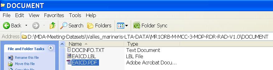
3 Browsing MCC data in Long Term Data Archive (LTA)
4

5 MAP view of MCC data coverage : Pin view
6 MAP view of MCC data coverage : Polygon view

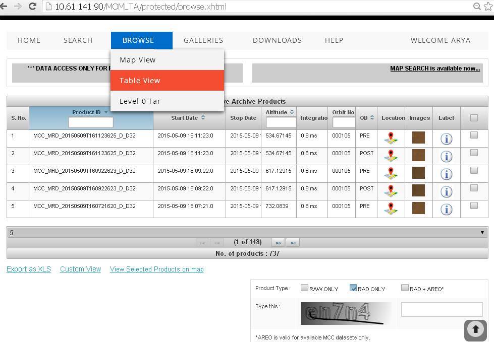
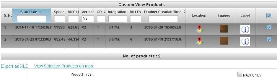
7 MCC data search by Date


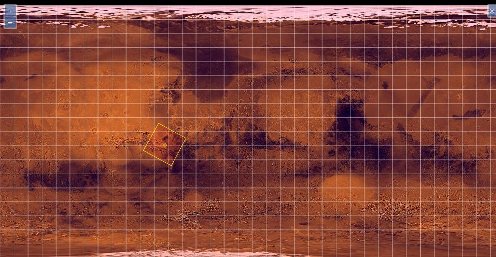
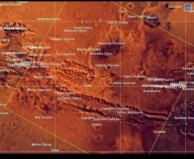
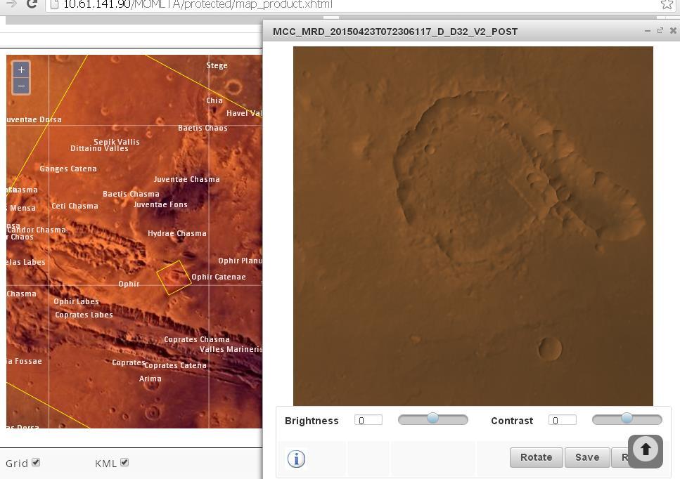
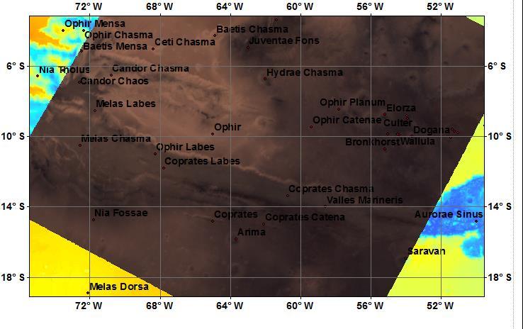
8 MCC data browse using Map search Case study: Ophir Catena from Valles Marineris region


9 MCC data browse using Map search Case study: Ophir Catena from Valles Marineris region

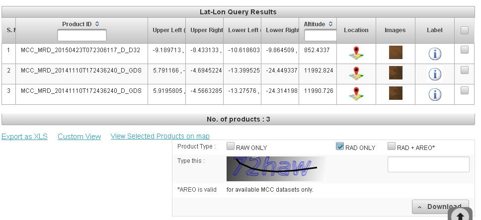
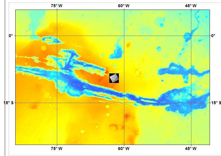
10 MCC data search by giving Longitude and Latitude extent of Region of Interest Case study: Pital crater from Valles Marineris region
11


12 Select Post OD (1)

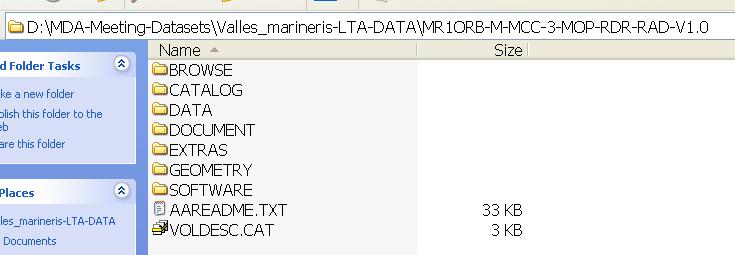
13


14 Footprints of Mars Color Camera data sets over Pital crater in ophir planum region This region having both high and coarse resolution data sets of MCC

15 Preview of MCC images
16 Meta information about data: Details about mission phase, start time and Exposure ID, integration time Continue...

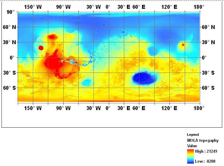
17 ...Continue Information about S/C Altitude in km Information about Sensor parameters


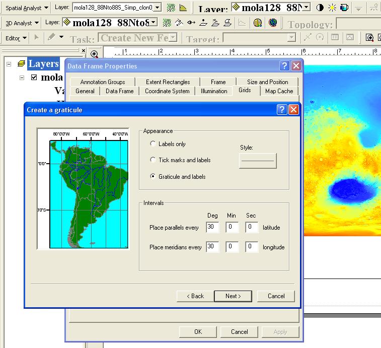
18 Information about 9 Corner co-ordinates, Spatial resolution...continue

19 Downloading of selected data sets
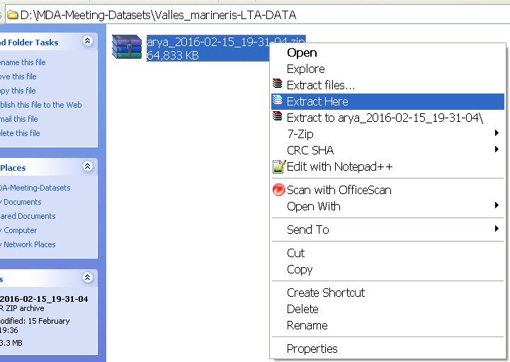
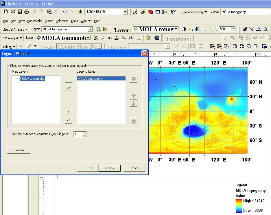
20 Extracting MCC data from *.tar file

21 Preview of *.PNG file in BROWSE folder


22 *.CAT files of CATALOG folder Provides meta information about data, instrument, institution, person, references related to data set DATA folder contains Count and Radiance images of MCC set-1 In this study
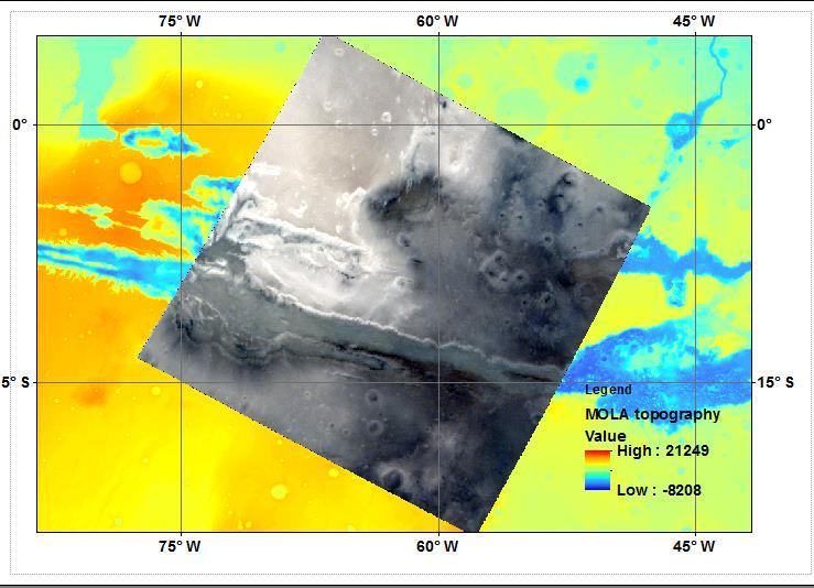
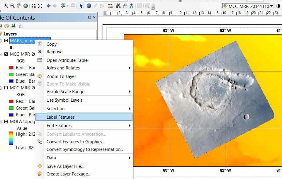
23
 and SPICE related parameters for set-1 in this")
24 EXTRAS foler consists of areo-refenced image (*.TIF) and SPICE related parameters for set-1 in this study

25 Base map Preparation in ARC GIS software 1) Loading of global MOLA topography data using Add Data button ( for Seamless compatibility over various data source)


26 2) Changing color palette of topography map Right click on MOLA topography layer Select the color pallete


27 3) Adding Grid lines and annotations to map

28 Changing the style of annotations/labels of map

29 Adding Legend to map


30 Adding MCC data set-1 to map


31 Adding MCC data set-2 of high spatial resolution

32 Adding Mars Nomenclature file to map


33 Area of geolomorphological interest Foot prints of MCC images in valles marineris region MCC Provides unique opportunity of imaging Same region of interest with various resolutions

34 Enhance / Contrast controls


35 Adding ``Mars Digital Image Mosaic (MDIM-2.1) as a reference image


36 Loading MOC-WA data in ARCMAP as a reference image


37 MCC: 623 meter,44 m/pixel MDIM:231 m/pixel MOC: resolution 231 meters


38 Creating shapefiles (Polygons) for digitization of areas from MCC,MOC, MDIM images using Arc catalogue

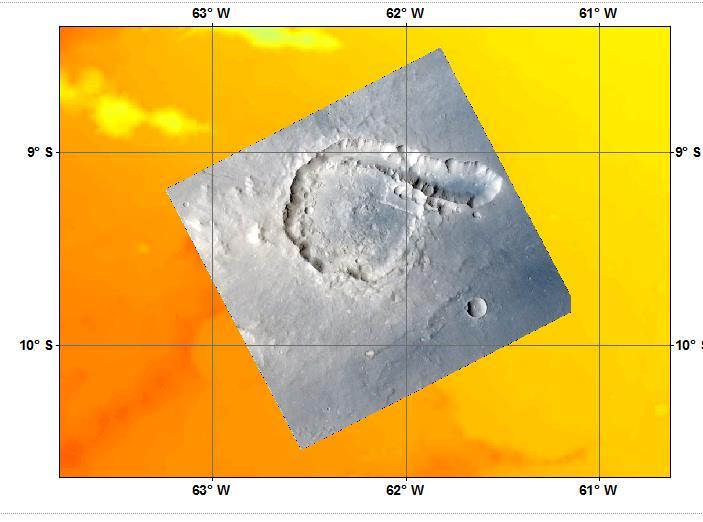
39 High resolution image of Pital crater in Ophir Planum region Pital crater N Pital crater is an impact crater having a diameter of ~40 km and located at 9 0 S, 62 0 W. Wall of the crater and chain of small impact craters are clearly seen in this image. 12 km Date of Acquisition: Space craft Altitude: 800 km Spatial resolution: 44m.

40 High resolution images of Impact crater SE of Bernard crater in Terra Sirenum region 10 km 2 1 N A concentric crater (1) super imposed over graben is also seen in this high resolution image. The relative position of this crater with respect to graben indicates that crater is younger than graben system. Larger crater having the diameter of 6 km. Three NE-SW trending grabens, and craters of various dimensions are clearly seen in this image. Part of regional graben system (2) of length 600 km is seen in this image. Date of Acquisition: Space craft Altitude: 442 km Spatial resolution: 23m.


41 Tectonic features: Regional faults cutting across craters in the Region around Comas Sola crater Comas sola crater A set of regional faults cutting across various craters, south of Comas sola crater are seen clearly in this image. Craters of various dimensions and wind streaks in bottom right side portion of the image are also clearly seen. 60 km Date of Acquisition: Space craft Altitude: 3453 km Spatial resolution: 179 m


42 Tectonic features: Wrinkle ridges Hesperia Planum region Wrinkle ridges and craters of smaller diameters are clearly seen in this image. Wrinkle ridges on planetary surface are formed due to compressional stress regime. Ridge means linear/ curvilinear elongated raised structure. 22 km Date of Acquisition: Space craft Altitude: 1132km. Spatial resolution: 58m

43 Volcanic features: Tyrrhenus Mons Hesperia Planum region N Tyrrhenus Mons is a volcano present in the Hesperin planum, located at ~21 0 S, E on Mars. Tyrrhenus Mons is having base diameter ~269 km..] Volcanism in Tyrrhenus Mons region occured around ~3.9 billion years ago. Concentric fractures systems seen in the MCC images are possibly formed by extensional stresses within the surface of Mars. Impressions of wind streaks can also be seen in this image. 50 km Date of Acquisition: Space craft Altitude: 3192 km. Spatial resolution: 166 m

44 Image of Wind streaks near to Kinkora crater observed by MCC Kinkora Crater N Wind streaks aligned along NW-SE direction are seen in this image. NE- SW aligned wrinkle ridge system to the west of Kinkora crater is also seen in this image. 30 km Date of Acquisition: Space craft Altitude: 2286 km Spatial resolution: 119 m Location: 25 0 S, E.

45 Global views of Mars captured during apo-imaging
46 Thank You
47 Remote sensing data sets of Mars sno 1 Instrument Mars Orbiter Laser Altimeter horizontal resolution 128 pixel per degree (460 m) for equatorial regions DEM vertical resolutio 1m Satellite/Mi sson Mission launch date Mars Global 07-Nov-96 Surveyor Martian orbit March,1999- june30,2001) Coverage Full globe coverage Viking Orbiter 1,2 Digital image mosaics Mars Orbiter Camera (MOC) Wide angle camera Mars Orbiter Camera (MOC) Narrow angle camera High resolution Stereo Camera (HRSC) Digital Elevation Model (DEM) High resolution Imaging Science Experiment (HiRISE) Compact Reconnaissance Imaging Spectrometer from Mars (CRISM) 925 meters/pixel red and blue wide angle cameras for context (240 m per pixel) grayscale (black-andwhite) high resolution images (typically 1.5 to 12 m per pixel) Ortho images:12.5/25 /50m; DTM: 50m/75m/100m images:25-30 cm/pixel DTM: 50m/pixel 18m/pixel 1 m 1m Viking Orbiter part of the globe Mars Global Surveyor 07-NOV-96 Mars Global 07-NOV-96 Surveyor Mars Express September 1997 and November 2006 September 1997 and November December,2003 to till date Full globe coverage Full globe coverage part of the globe Mars Reconnaiss 12-Aug-05 ance Dec. 7, 2006 till date part of the globe Orbiter Mars Reconnaiss 12-Aug-05 ance Dec. 7, 2006 till date Part of the Globe Orbiter
48 Viking MDIM2.1 Colorized Global Mosaic 232m This global image map of Mars has a resolution of 256 pixels/degree (scale approximately 231 m/pixel at the equator). The colorized mosaic was completed by NASA AMES which warped the original Viking colorized mosaic and blended over the lastest black/white mosaic (MDIM 2.1). The positional accuracy of features in MDIM 2.1 is estimated to be roughly one pixel (200 m), compared to 3 km for MDIM 2.0 released in 2001 and >6 km for MDIM 1.0 released in 1991
49 Details of Global data sets of Mars MGS MOC WA Atlas Mosaic (MSSS) This mosaic was generated by MSSS and ASU using Mars Global Surveyor (MGS) Mars Orbiter Camera (MOC) Wide Angle red images. For more details see: ftp://pdsimage2.wr.usgs.gov/pub/pigpen/mars/moc/msss_atlas_ocentric/moc_wa_atlas_256ppd_readme.txt Data Source: ftp://pdsimage2.wr.usgs.gov/pub/pigpen/mars/moc/ MGS MOLA Shaded Relief This is a shaded relief map from Mars Global Surveyor (MGS) MOLA instrument. Data Source: ftp://pdsimage2.wr.usgs.gov/pub/pigpen/mars/mola/colorshade_global_megt128ppd_merged64ppd/ MGS MOLA Topography (Goddard) This basemap layer was generated from Mars Global Surveyor (MGS) MOLA instrument data. For more details see: ftp://pdsimage2.wr.usgs.gov/pub/pigpen/mars/mola/mola128_88nto88s_simp_clon0.txt Data Source: ftp://pdsimage2.wr.usgs.gov/pub/pigpen/mars/mola/mola128_88nto88s_simp_clon0.zip MGS TES Global Albedo This basemap layer is a Mars Global Surveyor (MGS) TES bolometric albedo global map by Christensen. For more details see: ftp://pdsimage2.wr.usgs.gov/pub/pigpen/mars/tes/tes_global_albedo_simp0.txt Data Source: ftp://pdsimage2.wr.usgs.gov/pub/pigpen/mars/tes/tes_global_albedo_simp0.zip MGS TES Thermal Inertia Day (Putzig et al.) This basemap users thermal inertia maps derived from Mars Global Surveyor (MGS) Thermal Emission Spectrometer (TES) observations of the surface temperatures of Mars taken over three Mars-years from orbit 1583 to The maps were produced by Nathaniel E. Putzig at University of Colorado. For more details see: ftp://pdsimage2.wr.usgs.gov/pub/pigpen/mars/tes/putzig_thermal_inertia/tes_thermal_intertia_putzig2007_readme.txt Data Source: ftp://pdsimage2.wr.usgs.gov/pub/pigpen/mars/tes/putzig_thermal_inertia/ Odyssey THEMIS Day IR Global Mosaic This global mosaic was generated by THEMIS team/asu using Mars Odyssey THEMIS IR data. ftp://pdsimage2.wr.usgs.gov/pub/pigpen/mars/themis/themis_ir_global_mosaic/global_irday_512ppd/pgm_themis_irday_clon0_worldfiles_readme.txt Data Source: ftp://pdsimage2.wr.usgs.gov/pub/pigpen/mars/themis/themis_ir_global_mosaic/global_irday_512ppd/
50 MOC_WA_Atlas_256ppd_mosaic_west_geotiff Original MSSS Text: This mosaic was assembled from Wide Angle red images (primarily those acquired in May-June 1999) from the Mars Orbiter Camera. The mosaic has been produced at 64 and 256 pixels/degree. All quadrangles are complete except for the polar regions (MC-01 and MC-30) and areas on quads MC-24 through MC-29 south of 60S; these should be completed by early Processing Flow This mosaic is built entirely from MOC images, most acquired during the Geodesy Campaign (mapping cycle M01) and some in mapping cycles M00, M02, and M03. Where possible, nadir-looking images were used; some remaining gaps needed to be filled with off-nadir images. South polar coverage is provided by images taken in mapping cycles M10-M11. Additional south polar coverage will be acquired during the 2002 summer solstice. Each image was systematically processed by removing pixel-to-pixel variation and matching brightness to a lowresolution base map built by hand from MOC daily global map swaths. It was then map-projected, using the MOLA Digital Terrain Model to provide "orthophoto" topographic control (control sampling of 16 pixel/degree). Images with downlink data loss or corruption were processed with and without all corrupted fragments replaced by black, and the versions with errors present added to the mosaic only at the end. Mosaicking was performed in two steps. In the first step, large barely-overlapping image swaths were mosaicked using linear blending of the overlap regions to reduce the visual impact of the seam. In the second step, smaller fill images were added only in regions without coverage from the first step. Finally, the small gaps between adjacent swaths caused by slight timing mismatches between the end of one image and the start of the next on the same orbit were filled by linear interpolation. All of this processing was performed automatically by software written at MSSS. Once the images were selected, processing required less than 48 hours on a Sun SunBlade 1000 system with dual 750-Mhz UltraSPARC III processors and 4 GB of RAM.
David Baxter. GK-12 Summer Research Program Brown University Oliver Hazard Perry Middle School NASA Explorer School
 David Baxter GK-12 Summer Research Program Brown University Oliver Hazard Perry Middle School NASA Explorer School Department of Geological Sciences Planetary Geology Group Dr. Michael Wyatt Dr. James
providing 100-m per pixel resolution in nine ~1.0 µm wide infrared bands centered from
 Supporting Text The THEMS instrument consists of separate infrared and visible imagers providing 100-m per pixel resolution in nine ~1.0 µm wide infrared bands centered from 6.78 to 14.88 µm, and 18-m
Mapping the Surface of Mars Prelab. 1. Explain in your own words what you think a "geologic history" for a planet or moon is?
 Prelab 1. Explain in your own words what you think a "geologic history" for a planet or moon is? 2. Describe some of the major features seen on the Martian surface by various spacecraft missions over the
images may not align well. For this reason ripple migrations have only been calculated over two
 GSA DATA REPOSITORY 2013126 S. Silvestro et al. SUPPLEMENTARY INFORMATION: PERVASIVE AEOLIAN ACTIVITY ALONG ROVER CURIOSITY S TRAVERSE IN GALE CRATER, MARS S.Silvestro, D.A. Vaz, R.C. Ewing, A.P. Rossi,
The Main Points. The View from the Surface. Geology of Mars. Lecture #20: Reading:
 Surface of Mars Lecture #20: Geology and Geologic Processes View from the Surface History/Evolution of the surface Reading: Chapter 9.4 The Main Points Mars has had a geologically active past that has
Nathan Franklin. Spring, ES6973 Remote Sensing Image Processing and Analysis
 Investigations of Geologic Units and Structural Features on the flanks of Elysium Mons, Mars, Using Visible Images and General Thermal Signatures from THEMIS Nathan Franklin Spring, 2005 ES6973 Remote
THE NEW GEOLOGY OF MARS: TOP TEN RESULTS OF POST-VIKING GLOBAL MAPPING AND CRATER-DATING
 THE NEW GEOLOGY OF MARS: TOP TEN RESULTS OF POST-VIKING GLOBAL MAPPING AND CRATER-DATING K.L. Tanaka 1, J.A. Skinner, Jr. 1, C.M. Fortezzo 1, T.M. Hare 1, R.P. Irwin 2, T. Platz 3, G. Michael 3, J.M. Dohm
Automated Orbital Mapping
 Automated Orbital Mapping Statistical Data Mining of Orbital Imagery to Analyze Terrain, Summarize its Characteristics and Draft Geologic Maps David Wettergreen Carnegie Mellon University Motivation Geologic
QUESTION IMPORTANCE. It is important to find ice if the idea of humans on Mars would ever become a possibility.
 MSIP TEAM KAPPA SCIENCE QUESTION How can crater diameter and rampart diameter ratios of rampart craters be used to find different amounts of ice present in the Northern and Southern parts of Mars? HYPOTHESES
Minéralogie de Valles Marineris (Mars) par télédetection hyperspectrale: Histoire magmatique et sédimentaire de la région.
 par télédetection hyperspectrale: Histoire magmatique et sédimentaire de la région.") Minéralogie de Valles Marineris (Mars) par télédetection hyperspectrale: Histoire magmatique et sédimentaire de la région. Dr. Jessica Flahaut Chercheur postdoctoral, Institut d Astrophysique Spatiale,
Minéralogie de Valles Marineris (Mars) par télédetection hyperspectrale: Histoire magmatique et sédimentaire de la région. Dr. Jessica Flahaut Chercheur postdoctoral, Institut d Astrophysique Spatiale,
CONTROLLED TOPOGRAPHIC IMAGE MOSAICS FROM COMBINATION OF VIKING ORBITER IMAGES AND MARS ORBITER LASER ALTIMETER DATA. Working Group IV/5
 CONTROLLED TOPOGRAPHIC IMAGE MOSAICS FROM COMBINATION OF VIKING ORBITER IMAGES AND MARS ORBITER LASER ALTIMETER DATA Ernst HAUBER, Jürgen OBERST, Wolfgang ZEITLER, Monika KUSCHEL, Marita WÄHLISCH, Ralf
MERGING (MERGE / MOSAIC) GEOSPATIAL DATA
 GEOSPATIAL DATA") This help guide describes how to merge two or more feature classes (vector) or rasters into one single feature class or raster dataset. The Merge Tool The Merge Tool combines input features from input
This help guide describes how to merge two or more feature classes (vector) or rasters into one single feature class or raster dataset. The Merge Tool The Merge Tool combines input features from input
As you can see in the picture to the left, the dust devils on Mars are significantly larger than dust devils on Earth.
 A Study of Wind Streak and Dust Devil Track Direction in Syrtis Major to Establish Consistent Wind Direction and Determine if This Changes by Season. Mars Student Imaging Project March 2011 Rim Country
Lunar Reconnaissance Orbiter Camera Image Retrieval For the Big Moon Dig
 Lunar Reconnaissance Orbiter Camera Image Retrieval For the Big Moon Dig Tom Riley TomRiley@WoodwareDesigns.com November 22, 2014 File: LROCameraRetrivalmmdddyy.docx Work in Progress LRO in orbit (artist
Uncertainties: Limitations of Martian Granular Material Remote Sensing
 Uncertainties: Limitations of Martian Granular Material Remote Sensing Albert F. C. Haldemann Jet Propulsion Laboratory, California Institute of Technology. albert.f.haldemann@jpl.nasa.gov More Data, Better
LANDING SITE SELECTION FOR THE MARS SCIENCE LABORATORY AND IMPLICATIONS FOR MARS SAMPLE RETURN
 Miyamoto Landing Site LANDING SITE SELECTION FOR THE MARS SCIENCE LABORATORY AND IMPLICATIONS FOR MARS SAMPLE RETURN Horton Newsom, Ann Ollila, Nina Lanza, Institute of Meteoritics and Dept. of Earth and
ArcGIS Data Models: Raster Data Models. Jason Willison, Simon Woo, Qian Liu (Team Raster, ESRI Software Products)
") ArcGIS Data Models: Raster Data Models Jason Willison, Simon Woo, Qian Liu (Team Raster, ESRI Software Products) Overview of Session Raster Data Model Context Example Raster Data Models Important Raster
ArcGIS Data Models: Raster Data Models Jason Willison, Simon Woo, Qian Liu (Team Raster, ESRI Software Products) Overview of Session Raster Data Model Context Example Raster Data Models Important Raster
imars - Analysis of Mars multi-resolution images using autocoregistration, data mining and crowd source techniques : processed results a first look
 Page 1 j.muller@ucl.ac.uk Version: 31.03.2017 imars - Analysis of Mars multi-resolution images using autocoregistration, data mining and crowd source techniques : processed results a first look Jan-Peter
Name: Lab Instructor: Lab Section: GEO104: Planetary Geology LAB 10: MARS GEOLOGIC MAPPING
 Name: Lab Instructor: Lab Section: GEO104: Planetary Geology LAB 10: MARS GEOLOGIC MAPPING OBJECTIVES: I. Apply our understanding of relative age dating and geologic processes to the Moon II. Develop an
UNIVERSITY OF MARYLAND ASTRONOMY DEPARTMENT. Mars Cratering. Crater count isochrons of Arsia and Pavonis Mons
 UNIVERSITY OF MARYLAND ASTRONOMY DEPARTMENT Mars Cratering Crater count isochrons of Arsia and Pavonis Mons Paul Hearding and Ben McIlwain 5/21/2007 Imagery of Arsia and Pavonis Mons taken by Mars Global
Meter-scale slopes of candidate MER landing sites from point photoclinometry
 JOURNAL OF GEOPHYSICAL RESEARCH, VOL. 108, NO. E12, 8085, doi:10.1029/2003je002120, 2003 Meter-scale slopes of candidate MER landing sites from point photoclinometry Ross A. Beyer and Alfred S. McEwen
Mars for Earthlings. Purpose: Recognize the purpose and need for understanding the scale and context of various remote sensing imaging techniques.
 LESSON 4: Remote Sensing Mars In-Class Activity 1 Scale and Context Purpose: Recognize the purpose and need for understanding the scale and context of various remote sensing imaging techniques. Study the
Exploring Mars in Three Dimensions:
 Exploring Mars in Three Dimensions: Classroom Activities and Lessons on Mars Exploration by David V. Black Walden School of Liberal Arts, 2011 elementsunearthed@gmail.com http://elementsunearthed.com/downloads
Question. Which volcano on the Tharsis region of Mars is the youngest?
 Question Which volcano on the Tharsis region of Mars is the youngest? Importance We believe that this question is important and interesting because we don t have any evidence of recent tectonic activity
EnvSci 360 Computer and Analytical Cartography
 EnvSci 360 Computer and Analytical Cartography Lecture 7 Mapping Images, Surfaces, and 3-D Data Brief Overview of Imagery What is Imagery? A spatial data model that defines space as an array of equally
Automated Identification and Characterization of Landforms on Mars
 Automated Identification and Characterization of Landforms on Mars Tomasz F. Stepinski Lunar and Planetary Institute Collaborators: Wei Luo Students: Brain Bue Ian Molloy Erik Urbach Michael Mendenhall
Type of Exercise: In-Class Activity or Laboratory Exercise.
 Using Lava Flows & Volcanic Structures on Mars to Introduce the Concept of Relative Dating in Introductory Courses Audeliz Matias Skidmore College, Saratoga Springs, NY 12866 amatias@skidmore.edu Type
Gray Iron Oxide in Meridiani, Mars
 : 1 of 8 posted March 13, 2003 Gray Iron Oxide in Meridiani, Mars --- A deposit of gray hematite in Terra Meridiani may suggest that water once circulated through the rock layers in this region of Mars.
JOURNAL OF GEOPHYSICAL RESEARCH, VOL. 111, E06014, doi: /2004je002363, 2006
 JOURNAL OF GEOPHYSICAL RESEARCH, VOL. 111,, doi:10.1029/2004je002363, 2006 Thermal properties of sand from Thermal Emission Spectrometer (TES) and Thermal Emission Imaging System (THEMIS): Spatial variations
Presentation given to computer science undergraduate students at the University of Houston July 2007
 Presentation given to computer science undergraduate students at the University of Houston July 2007 Machine Learning and Data Mining in Mars Tomasz F. Stepinski Lunar and Planetary Institute MARS/EARTH
CHANNELS ON MARS. KWL Prior Knowledge/Engagement Activity
 CHANNELS ON MARS KWL Prior Knowledge/Engagement Activity In your small group, brainstorm ideas about what you think you know about channels and what questions you have about channels on Mars. You will
Martian Crater Dating through Isochrons. The universe is a vast and seemingly-endless array of space and matter that
 Gary Studen ASTR 498 5/13/05 Martian Crater Dating through Isochrons Introduction The universe is a vast and seemingly-endless array of space and matter that harbors many mysteries. Through advances in
Highs and Lows Floods and Flows
 Highs and Lows Floods and Flows Planetary Mapping Facilitator Guide Becky Nelson Education Specialist The Lunar and Planetary Institute Highs and Lows, Floods and Flows Planetary Mapping Overview In this
Surface Observations Including from the 2012 Mars Curiosity Rover. Martian Atmosphere
 Aspects Dynamical of Martian Meteorology Meteorology of From the Surface Observations Including from the 2012 Mars Curiosity Rover Martian Atmosphere Mars Science Laboratory Curiosity The Curiosity rover
PROANA A USEFUL SOFTWARE FOR TERRAIN ANALYSIS AND GEOENVIRONMENTAL APPLICATIONS STUDY CASE ON THE GEODYNAMIC EVOLUTION OF ARGOLIS PENINSULA, GREECE.
 PROANA A USEFUL SOFTWARE FOR TERRAIN ANALYSIS AND GEOENVIRONMENTAL APPLICATIONS STUDY CASE ON THE GEODYNAMIC EVOLUTION OF ARGOLIS PENINSULA, GREECE. Spyridoula Vassilopoulou * Institute of Cartography
Determining the Location of the Simav Fault
 Lindsey German May 3, 2012 Determining the Location of the Simav Fault 1. Introduction and Problem Formulation: The issue I will be focusing on involves interpreting the location of the Simav fault in
Bradley Central High School 4 th Hour Physics. Introduction:
 Bradley Central High School 4 th Hour Physics Introduction: Our scientific question is, is there a connection between the location and size of a crater. Our underlying questions are, is there a correlation
LAVA FLOWS IN THE THARSIS REGION OF MARS: ESTIMATES OF FLOW SPEEDS AND VOLUME FLUXES
 LAVA FLOWS IN THE THARSIS REGION OF MARS: ESTIMATES OF FLOW SPEEDS AND VOLUME FLUXES Carolyn Parcheta Department of Geology and Geophysics University of Hawai i at Manoa Honolulu, HI 96822 ABSTRACT The
Hi-resolution Solar System textures for SpaceEngine 0.98
 Hi-resolution Solar System textures for SpaceEngine 0.98 These addons Solar System HD and Solar System Ultra contains hi-resolution maps of some planets, moons and asteroids of the Solar System. The maps
Handling Raster Data for Hydrologic Applications
 Handling Raster Data for Hydrologic Applications Prepared by Venkatesh Merwade Lyles School of Civil Engineering, Purdue University vmerwade@purdue.edu January 2018 Objective The objective of this exercise
The Latest from Mars: Recent Results and the Next Decade of Exploration
 The Latest from Mars: Recent Results and the Next Decade of Exploration Brian M. Hynek Laboratory for Atmospheric and Space Physics & Department of Geological Sciences, University of Colorado Mars ½ diameter
Meter-scale slopes of candidate MER landing sites from point photoclinometry
 JOURNAL OF GEOPHYSICAL RESEARCH, VOL. 108, NO. E12, 2003JE002120, December 2003 Meter-scale slopes of candidate MER landing sites from point photoclinometry Ross A. Beyer and Alfred S. McEwen Department
Science planning and operations for Mars Express
 Science planning and operations for Mars Express René Pischel and Tanja Zegers ESA/ESTEC, Research and Scientific Support Department, Postbus 299, 2200 AG Noordwijk, The Netherlands I. Introduction The
Tectonic landforms. Global distribution Extension. Compression. Strike-slip faults Outlook: Implications for geophysics
 Tectonic landforms Global distribution Extension Long and narrow graben ( simple grabens ) Complex graben systems ( rifts ) Compression Wrinkle ridges Lobate scarps Strike-slip faults Outlook: Implications
ISRO Science Data Archive: Chandrayaan-1
 Chandrayaan-1 1 Payloads ISRO Science Data Archive: Chandrayaan-1 (and sample imagery) B Gopala Krishna Group Head, SPDCG/SIPA Space Applications Centre (ISRO) Ahmedabad,, INDIA bgk@sac.isro.gov.in Indian
INTERNATIONAL PHOBOS/DEIMOS LANDING SITE WORKING GROUP
 INTERNATIONAL PHOBOS/DEIMOS LANDING SITE WORKING GROUP by Thomas Duxbury Physics and Astronomy Department George Mason University Fairfax, VA, USA presented at the Small Bodies Assessment Group 16 th Meeting
Studying Topography, Orographic Rainfall, and Ecosystems (STORE)
") Introduction Studying Topography, Orographic Rainfall, and Ecosystems (STORE) Lesson: Using ArcGIS Explorer to Analyze the Connection between Topography, Tectonics, and Rainfall GIS-intensive Lesson This
Introduction Studying Topography, Orographic Rainfall, and Ecosystems (STORE) Lesson: Using ArcGIS Explorer to Analyze the Connection between Topography, Tectonics, and Rainfall GIS-intensive Lesson This
Ronald Wilhelm & Jennifer Wilhelm, University of Kentucky Ages on Mars. Martian Surface Age Exploration
 Ronald Wilhelm & Jennifer Wilhelm, University of Kentucky 2008 Ages on Mars Martian Surface Age Exploration You have now learned some very important things about various planets and moons in our Solar
Preliminary Scientific Results of Chang E-1 Lunar Orbiter:BasedonPayloadsDetectionData in the First Phase
 0254-6124/2008/28(5)-361 09 Chin. J. Space Sci. Ouyang Ziyuan, Jiang Jingshan, Li Chunlai, Sun Huixian, Zou Yongliao, Liu Jianzhong, Liu Jianjun, Zhao Baochang, Ren Xin, Yang Jianfeng, Zhang Wenxi, Wang
Moon 101. Bellaire High School Team: Rachel Fisher, Clint Wu, Omkar Joshi
 Moon 101 Bellaire High School Team: Rachel Fisher, Clint Wu, Omkar Joshi Part I Formation of the Moon Planetary Formation In the solar nebula, dust particles coalesced to form smaller planetesimals and
REVISED COORDINATES FOR APOLLO HARDWARE
 REVISED COORDINATES FOR APOLLO HARDWARE R. V. Wagner *, E. J. Speyerer, K. N. Burns, J. Danton, M.S. Robinson Lunar Reconnaissance Orbiter Camera, School of Earth and Space Exploration, Arizona State University,
Why is this ques0on important and interes0ng? Our ques-on is interes-ng because we want to see if wind veloci-es can vary around Alba Patera.
 What is your science ques0on? Can wind streak ra-os be used to determine wind velocity differences in the eleva-on band of 2500-5000m around Alba Patera? Why is this ques0on important and interes0ng? Our
Geomorphologic Mapping by Airborne Laser Scanning in Southern Victoria Land
 Geomorphologic Mapping by Airborne Laser Scanning in Southern Victoria Land Bea Csatho, Terry Wilson, Tony Schenk, Garry McKenzie, Byrd Polar Research Center, The Ohio State University, Columbus, OH William
Lauren Jacob May 6, Tectonics of the Northern Menderes Massif: The Simav Detachment and its relationship to three granite plutons
 Lauren Jacob May 6, 2010 Tectonics of the Northern Menderes Massif: The Simav Detachment and its relationship to three granite plutons I. Introduction: Purpose: While reading through the literature regarding
Trent Hare, Lisa Gaddis, Sue LaVoie, Chris Isbell, Moses Milazzo, Sam Lawrence
 Trent Hare, Lisa Gaddis, Sue LaVoie, Chris Isbell, Moses Milazzo, Sam Lawrence PDS Cartography and Imaging Sciences Node The Imaging Node (IMG, PDS-IMG or just Imaging ) http://img.pds.nasa.gov/ Curator
Gray hematite distribution and formation in Ophir and Candor chasmata
 JOURNAL OF GEOPHYSICAL RESEARCH, VOL. 113,, doi:10.1029/2007je002930, 2008 Gray hematite distribution and formation in Ophir and Candor chasmata Catherine M. Weitz, 1 Melissa D. Lane, 1 Matthew Staid,
FADING OF SLOPE STREAKS ON MARS OVER THREE DECADES: A COMPARISON OF CTX AND VIKING IMAGES
 FADING OF SLOPE STREAKS ON MARS OVER THREE DECADES: A COMPARISON OF CTX AND VIKING IMAGES Kimberly M. Rottas Department of Geology and Geophysics University of Hawai i at Mānoa Honolulu, HI 96822 ABSTRACT
Metadata for 2005 Orthophotography Products
 Metadata for 2005 Orthophotography Products What does this data set describe? 1. How should this data set be cited? 2. What geographic area does the data set cover? 3. What does it look like? 4. Does the
Mars Reconnaissance Orbiter Observa3on Plan for Comet Siding Spring Encounter
 Mars Reconnaissance Orbiter Observa3on Plan for Comet Siding Spring Encounter Leslie Tamppari, MRO Deputy Project Scien3st Jet Propulsion Laboratory, California Ins3tute of Tehcnology 8/11/14 Mars Reconnaissance
Watershed Modeling Orange County Hydrology Using GIS Data
 v. 10.0 WMS 10.0 Tutorial Watershed Modeling Orange County Hydrology Using GIS Data Learn how to delineate sub-basins and compute soil losses for Orange County (California) hydrologic modeling Objectives
4.2 Valles Marineris 99
 4.2 Valles Marineris 99 Ganges 2: The ILD (7.4 S/313.1 E) is located in the eastern Valles Marineris (Fig. 2, 10), in Ganges Chasma (Fig. 28), east of Ganges 1 (Fig. 52). Ganges 2 shows a N-S strike, measures
Cratering and the Martian Surface
 Lab 4 Cratering and the Martian Surface 4.1 Overview Exercise four continues our study of terrestrial surface evolution, shifting from the Moon to Mars and exploiting an extensive reservoir of recent high-resolution
Examining the Terrestrial Planets (Chapter 20)
") GEOLOGY 306 Laboratory Instructor: TERRY J. BOROUGHS NAME: Examining the Terrestrial Planets (Chapter 20) For this assignment you will require: a calculator, colored pencils, a metric ruler, and your geology
GEOLOGY 306 Laboratory Instructor: TERRY J. BOROUGHS NAME: Examining the Terrestrial Planets (Chapter 20) For this assignment you will require: a calculator, colored pencils, a metric ruler, and your geology
Digital Elevation Models (DEM) / DTM
 / DTM") Digital Elevation Models (DEM) / DTM Uses in remote sensing: queries and analysis, 3D visualisation, layers in classification Fogo Island, Cape Verde Republic ASTER DEM / image Banks Peninsula, Christchurch,
Digital Elevation Models (DEM) / DTM Uses in remote sensing: queries and analysis, 3D visualisation, layers in classification Fogo Island, Cape Verde Republic ASTER DEM / image Banks Peninsula, Christchurch,
Geomorphological analysis of Ares Vallis (Mars) by using HRSC (MEX) data: catastrophic floods and glacial morphologies
 by using HRSC (MEX) data: catastrophic floods and glacial morphologies") Mem. S.A.It. Suppl. Vol. 11, 119 c SAIt 2007 Memorie della Supplementi Geomorphological analysis of Ares Vallis (Mars) by using HRSC (MEX) data: catastrophic floods and glacial morphologies A. Pacifici,
Mem. S.A.It. Suppl. Vol. 11, 119 c SAIt 2007 Memorie della Supplementi Geomorphological analysis of Ares Vallis (Mars) by using HRSC (MEX) data: catastrophic floods and glacial morphologies A. Pacifici,
Mars for Earthlings. Purpose: Observe and rank potential Earth analogs for Mars planetary study.
 LESSON 1: Introduction In Class Activity 1 Mars Analogs Purpose: Observe and rank potential Earth analogs for Mars planetary study. Earth Analogs 1. What do you think scientists mean by an earth analog
Height Concordance of Martian Volcanoes Over Time
 Height Concordance of Martian Volcanoes Over Time John Moores for PTYS 511 Lunar and Planetary Laboratory, University of Arizona, Tucson AZ Submitted: December 8, 23 Abstract An update to Carr s 1976 paper
LRO-LOLA: Measurements of Lunar Altimetry and Surface Conditions
 LRO-LOLA: Measurements of Lunar Altimetry and Surface Conditions David E. Smith, MIT Maria T. Zuber, MIT Gregory A. Neumann, GSFC Erwan Mazarico, GSFC and the LOLA Science Team Lunar-Glob Mission International
What are terrestrial planets like on the inside? Chapter 9 Planetary Geology: Earth and the Other Terrestrial Worlds. Seismic Waves.
 Chapter 9 Planetary Geology: Earth and the Other Terrestrial Worlds What are terrestrial planets like on the inside? Seismic Waves Vibrations that travel through Earth s interior tell us what Earth is
27 June Mars Exploration Program Advisory Group (MEPAG) Dear Colleagues,
 Dear Colleagues,") 27 June 2003 Mars Exploration Program Advisory Group (MEPAG) Dear Colleagues, The arrival of the Mars Exploration Rovers (MER) at Mars, joining Mars Global Surveyor (MGS) and Odyssey, offers an unprecedented
27 June 2003 Mars Exploration Program Advisory Group (MEPAG) Dear Colleagues, The arrival of the Mars Exploration Rovers (MER) at Mars, joining Mars Global Surveyor (MGS) and Odyssey, offers an unprecedented
InSight Spacecraft Launch for Mission to Interior of Mars
 InSight Spacecraft Launch for Mission to Interior of Mars InSight is a robotic scientific explorer to investigate the deep interior of Mars set to launch May 5, 2018. It is scheduled to land on Mars November
Data Structures & Database Queries in GIS
 Data Structures & Database Queries in GIS Objective In this lab we will show you how to use ArcGIS for analysis of digital elevation models (DEM s), in relationship to Rocky Mountain bighorn sheep (Ovis
Generation and analysis of Digital Elevation Model (DEM) using Worldview-2 stereo-pair images of Gurgaon district: A geospatial approach
 using Worldview-2 stereo-pair images of Gurgaon district: A geospatial approach") 186 Generation and analysis of Digital Elevation Model (DEM) using Worldview-2 stereo-pair images of Gurgaon district: A geospatial approach Arsad Khan 1, Sultan Singh 2 and Kaptan Singh 2 1 Department
186 Generation and analysis of Digital Elevation Model (DEM) using Worldview-2 stereo-pair images of Gurgaon district: A geospatial approach Arsad Khan 1, Sultan Singh 2 and Kaptan Singh 2 1 Department
Topography of valley networks on Mars from Mars Express High Resolution Stereo Camera digital elevation models
 JOURNAL OF GEOPHYSICAL RESEARCH, VOL. 113,, doi:10.1029/2007je002986, 2008 Topography of valley networks on Mars from Mars Express High Resolution Stereo Camera digital elevation models Véronique Ansan,
Identification and Evaluation of the Mars Global Surveyor MOLA Profile of the Mars Face
 2001 New Frontiers in Science (ISSN 1537-3169) newfrontiersinscience.com Identification and Evaluation of the Mars Global Surveyor MOLA Profile of the Mars Face Lan Fleming (LanFleming@aol.com) The method
SCIENCE WITH DIRECTED AERIAL DR. ALEXEY PANKINE GLOBAL AEROSPACE CORPORATION SAILING THE PLANETS
 : SCIENCE WITH DIRECTED AERIAL ROBOT EXPLORERS (DARE) DR. ALEXEY PANKINE GLOBAL AEROSPACE CORPORATION 1 NEW ARCHITECTURE FOR PLANETARY EXPLORATION KEY ELEMENTS: Long-Duration Planetary Balloon Platforms
Current Status of the Stratospheric Ozone Layer From: UNEP Environmental Effects of Ozone Depletion and Its Interaction with Climate Change
 Goals Produce a data product that allows users to acquire time series of the distribution of UV-B radiation across the continental USA, based upon measurements from the UVMRP. Provide data in a format
Digital Elevation Model (DEM) Generation from Stereo Images
 Generation from Stereo Images") Pertanika J. Sci. & Technol. 19 (S): 77-82 (2011) ISSN: 0128-7680 Universiti Putra Malaysia Press Digital Elevation Model (DEM) Generation from Stereo Images C. E. Joanna Tan *, M. Z. Mat Jafri, H. S.
Pertanika J. Sci. & Technol. 19 (S): 77-82 (2011) ISSN: 0128-7680 Universiti Putra Malaysia Press Digital Elevation Model (DEM) Generation from Stereo Images C. E. Joanna Tan *, M. Z. Mat Jafri, H. S.
GOSAT mission schedule
 GOSAT mission schedule 29 21 12 1 2 3 4 6 7 8 9 1 11 12 1 2 214 1 2 3 ~ Jan. 23 Launch Initial Checkout Initial function check Initial Cal. and Val. Mission life Normal observation operation Extra Operati
Lecture Outlines. Chapter 10. Astronomy Today 8th Edition Chaisson/McMillan Pearson Education, Inc.
 Lecture Outlines Chapter 10 Astronomy Today 8th Edition Chaisson/McMillan Chapter 10 Mars Units of Chapter 10 10.1 Orbital Properties 10.2 Physical Properties 10.3 Long-Distance Observations of Mars 10.4
WORKING WITH DMTI DIGITAL ELEVATION MODELS (DEM)
") WORKING WITH DMTI DIGITAL ELEVATION MODELS (DEM) Contents (Ctrl-Click to jump to a specific page) Manipulating the DEM Step 1: Finding the DEM Tiles You Need... 2 Step 2: Importing the DEM Tiles into ArcMap...
WORKING WITH DMTI DIGITAL ELEVATION MODELS (DEM) Contents (Ctrl-Click to jump to a specific page) Manipulating the DEM Step 1: Finding the DEM Tiles You Need... 2 Step 2: Importing the DEM Tiles into ArcMap...
The Geodatabase Working with Spatial Analyst. Calculating Elevation and Slope Values for Forested Roads, Streams, and Stands.
 GIS LAB 7 The Geodatabase Working with Spatial Analyst. Calculating Elevation and Slope Values for Forested Roads, Streams, and Stands. This lab will ask you to work with the Spatial Analyst extension.
Submitted to. Prepared by
 Prepared by Tim Webster, PhD Candace MacDonald Applied Geomatics Research Group NSCC, Middleton Tel. 902 825 5475 email: tim.webster@nscc.ca Submitted to Harold MacNeil Engineering Manager Halifax Water
Europe to the Moon. BHF 10 Feb 2005 SPC
 Europe to the Moon V162 lift-off on 27 September 2003 at 23:14:39 UTC The launch was perfect SMART-1 separated at 23:56:03 into a GTO (656 x 35,881 km): perfect injection 100 s later telemetry was received
Interpolation Techniques
 Interpolation Techniques Using QGIS Tutorial ID: IGET_SA_002 This tutorial has been developed by BVIEER as part of the IGET web portal intended to provide easy access to geospatial education. This tutorial
Lecture 9: Reference Maps & Aerial Photography
 Lecture 9: Reference Maps & Aerial Photography I. Overview of Reference and Topographic Maps There are two basic types of maps? Reference Maps - General purpose maps & Thematic Maps - maps made for a specific
GeoSUR SRTM 30-m / TPS
 GeoSUR SRTM 30-m / TPS Wm Matthew Cushing (USGS) 16 May 2013 U.S. Department of the Interior U.S. Geological Survey SRTM Mission Shuttle Radar Topography Mission (SRTM) Space Shuttle Endeavour during the
Are There Plate Tectonics on Mars? 5 th Grade Class of 2013 John Read Middle School Redding, CT 06896
 Are There Plate Tectonics on Mars? 5 th Grade Class of 2013 John Read Middle School Redding, CT 06896 Introduction: Are there plate tectonics on Mars? Could plate tectonics explain the formation of Valles
Mars W cloud: Evidence of nighttime ice depositions
 GEOPHYSICAL RESEARCH LETTERS, VOL. 36, L14204, doi:10.1029/2009gl039061, 2009 Mars W cloud: Evidence of nighttime ice depositions Y. Moudden 1 and J. M. Forbes 1 Received 5 May 2009; revised 10 June 2009;
A AVHRR NDVI dataset for Svalbard. Stian Solbø, Inge Lauknes, Cecilie Sneberg Grøtteland, Stine Skrunes, Hannah Vickers, Kjell Arild Høgda
 A 1986-2014 AVHRR NDVI dataset for Svalbard Stian Solbø, Inge Lauknes, Cecilie Sneberg Grøtteland, Stine Skrunes, Hannah Vickers, Kjell Arild Høgda AVHRR series of satellites/instruments Satellite name
IMPROVED LARGE-SCALE SLOPE ANALYSIS ON MARS BASED ON CORRELATION OF SLOPES DERIVED WITH DIFFERENT BASELINES
 IMPROVED LARGE-SCALE SLOPE ANALYSIS ON MARS BASED ON CORRELATION OF SLOPES DERIVED WITH DIFFERENT BASELINES Yiran Wang, Bo Wu * Dept. of Land Surveying and Geo-Informatics, Hong Kong Polytechnic University,
In this exercise we will learn how to use the analysis tools in ArcGIS with vector and raster data to further examine potential building sites.
 GIS Level 2 In the Introduction to GIS workshop we filtered data and visually examined it to determine where to potentially build a new mixed use facility. In order to get a low interest loan, the building
The Effects of Atmospheric Variations on the High Energy Radiation Environment at the Surface of Mars
 The Effects of Atmospheric Variations on the High Energy Radiation Environment at the Surface of Mars A. Keating, Laboratório de Instrumentação e Física Experimental de Partículas, Lisbon, Portugal (keating@lip.pt)
Change detection at the recently erupted Te Maari crater, Tongariro, from stereo aerial photographs
 Change detection at the recently erupted Te Maari crater, Tongariro, from stereo aerial photographs Strong, D.T., Jones, K.E., Ashraf, S. and Lee, J. Outline Geographic context Setting and eruption Science
Brookhaven Academy. 8 th Grade Earth Science Final Report
 Brookhaven Academy 8 th Grade Earth Science Final Report Introduction and Hypothesis: Science Question: What effect does elevation have on Martian lava flows? Our class was interested in conducting Earth
Initial Observations and Strategies
 STUDENT WORKSHEET 1 Initial Observations and Strategies Name(s) Date Look at the Thermal Emission Imaging System (THEMIS) Daytime Infrared (IR) image mosaic your teacher has given you. You will be investigating
Welcome to NR502 GIS Applications in Natural Resources. You can take this course for 1 or 2 credits. There is also an option for 3 credits.
 Welcome to NR502 GIS Applications in Natural Resources. You can take this course for 1 or 2 credits. There is also an option for 3 credits. The 1st credit consists of a series of readings, demonstration,
SOLAR WIND VOLATILE PRESERVATION. Samantha R. Jacob Department of Geology and Geophysics University of Hawai i at Mānoa Honolulu, HI ABSTRACT
 SOLAR WIND VOLATILE PRESERVATION Samantha R. Jacob Department of Geology and Geophysics University of Hawai i at Mānoa Honolulu, HI 96822 ABSTRACT Because the Moon has a negligible atmosphere and magnetosphere,
Utilization and Provision of Geographical Name Information on the Basic Map of Japan*
 UNITED NATIONS WORKING PAPER GROUP OF EXPERTS NO. 1/9 ON GEOGRAPHICAL NAMES Twenty-eight session 28 April 2 May 2014 Item 9 of the Provisional Agenda Activities relating to the Working Group on Toponymic
NR402 GIS Applications in Natural Resources
 NR402 GIS Applications in Natural Resources Lesson 1 Introduction to GIS Eva Strand, University of Idaho Map of the Pacific Northwest from http://www.or.blm.gov/gis/ Welcome to NR402 GIS Applications in