LAPL(A)/PPL(A) question bank FCL.215, FCL.120 Rev_1/2016 NAVIGATION 060
|
|
|
- Ruby Bailey
- 5 years ago
- Views:
Transcription
1 NAVIGATION 060 1
2 1 What is the angle of inclination of the Earth's axis to its orbital plane? 66,5 23,5 33, The meridian passing through Greenwich is known as? Main Meridian. Great Meridian. Prime Meridian. Equator. 3 A Rhumb Line is? A line on the surface of the Earth whose centre and radius are those of the Earth. A line showing True north. A regularly curved line on the Earth's surface which cuts all parallels of Latitude at the same angle. A regularly curved line on the Earth's surface which cuts all meridians at the same angle. 4 Variation is the angle between: True north and Magnetic north. Magnetic north and the aircraft's True heading. True north and the nearest line of Longitude. Magnetic north and the aircraft's Magnetic heading. 5 An isogonal is a line joining points of: Zero magnetic variation. Equal magnetic deviation. Zero magnetic deviation. Equal magnetic variation. 6 Which points on the Earth's surface determine the Earth's axis? North geographic pole and north magnetic pole. North and south geographic pole. Equator-hemisphere. North and south magnetic pole. 7 The circumference of the Earth along the Equator is: NM km km NM. 2
3 8 The Earth's diameter, when compared to the Earth' axis, is: Twice as much greater. Shorter by 42 km. The same. Longer by 43 km. 9 Which of the following statements, regarding rotation of the Earth around the Sun, is correct? The Earth: Encircles the Sun in one year. Does not circle around the Sun because it is stationary with the Sun circling around it. Encircles the Sun in one day. Encircles the Sun one time during summer and one time during winter. 10 The Earth's globe rotates: Around its axis in the direction from the west to the east. Together with the Sun in the direction from the east to the west. Around its axis in the direction from the east to the west. Around so called Sun's tropic. 11 The orbit of the Earth is: A circle around which the Sun rotates. An ellipse with the Sun at different point inside it. A circle with the Sun at the center. An ellipse with the Sun at one of the foci. 12 What is the cause of the seasons? Uneven temperatures in space. The tilt of the Earth's axis. Irregular movement of the Earth around the Sun. A shape of the Earth's orbit. 13 The shortest distance between two points on the Earth's globe is called: Rhumb line. Great circle. Lambodrome. Small circle. 14 Great Circle(s) on the Earth's surface is(are): The equator, meridians and parallels of latitude. The equator, meridians and orthodroms. The equator and meridians. The equator only. 3
4 15 The equator is the Great Circle which plane: Divides the Earth's globe into the westerly and easterly hemisphere. Divides the Earth's globe into the north and south hemisphere. Divides the Earth's globe into the east and west hemisphere. Is parallel to the Earth's axis. 16 How many Great Circles (orthodroms) can be determined on the Earth's surface? An infinite number The Great Circle on the Earth's globe is the cross-section of the Earth's surface and the plane passing through: The center of the Earth and is tilt to the Earth's axis at any angle. Any two points on the Earth's surface; the cross-section with the Earth's surface is the shortest distance between these points. The center of the Earth and is always oblique to the Earth's axis. The center of the Earth and is always rectangular to the Earth's axis. 18 Which of the following circles on the Earth's globe does not have the center at the Earth's center? Great Circle. Orthodrom. Small Circle. Equator. 19 What is the characteristic of the Rhumb Line? It is the Great Circle. It is the shortest distance between two points on the Earth's globe. It cuts meridians under constant angle. It cuts meridians under various angles. 20 Which circles, forming the graticule, are at the same time Great Circles and Rhumb Lines? Meridians and equator. Meridians only. Equator only. Parallel of latitude only. 21 The Sun travels across the sky an arc of 5 in: 30 minutes. 4 minutes. 20 minutes. 60 minutes. 4
5 22 What time is needed for the Sun's azimuth to change by 27 arc degrees? 135 minutes. 90 minutes. 30 minutes. 108 minutes. 23 The Co-ordinated Universal Time (UTC) is: The MidEuropean Time. The Zone Time. The Local Time. The time on the longitude 0 degrees :00 accordingly to the Finnish Summer Time is: 1200 UTC UTC UTC UTC. 25 An aircraft over Helsinki is headed exactly to the south. It is 1200 UTC. What is the Relative bearing of the Sun? Left of the aircraft's nose. May be left or right of the aircraft's nose, with regard to the season. Exactly straight-in. Right of the aircraft's nose. 26 The geographic latitude is the distance of a point on the Earth's surface from the: Equator, measured in statute miles. Equator, measured in arc degrees. Prime Meridian, measured in geographic miles. Prime Meridian, measured in arc degrees. 27 What is the latitude of a point on the Equator? 180 S S. 90 N. 5
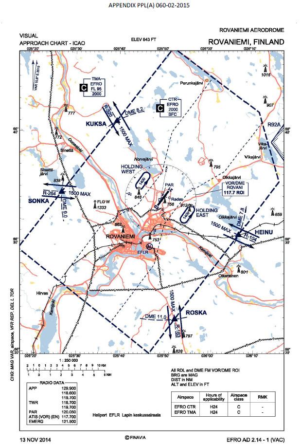
6 28 What is the difference between the latitude of the point A and the point B, which are located on following parallels of latitude: A: 15 54' 30" N B: 10 33' 30" S 25 27' 00" ' 00" ' 00" ' 00". 29 Determine the latitude of the point B, located 240 NM north of the point A with the latitude 62 33' 00" N ' 00" N ' 00" N ' 00" N ' 00" N. 30 The distance between the parallel of latitude 10 N and the parallel of latitude 11 N, measured along the meridian, is: 111 km. 60 SM. 60 km. 111 NM. 31 For this question use appendix PPL(A) The geographical coordinates of the compulsory reporting point MINNE is? N 62 56' 48" and E ' 43". N 60 56' 48" and E ' 43". N 62 46' 48" and E ' 43". N 62 56' 48" and W ' 43". 32 For this question use appendix PPL(A) The geographical coordinates of the compulsory reporting point TERVA is? N 63 59' 33" and E ' 11". S 62 59' 33" and E ' 11". N 62 59' 33" and E ' 11". N 62 59' 33" and E ' 11". 33 For this question use appendix PPL(A) The geographical coordinates of the compulsory reporting point VASSO is? N 63 09' 28" and E ' 40". N 62 09' 28" and E ' 40". N 63 09' 28" and E ' 40". E 63 09' 28" and N ' 39". 6
7 34 For this question use appendix PPL(A) What compulsory reporting point is the most convenient to use when approaching EFVA on radial 220? TERVA MINNE KOSSU VASSO 35 For this question use appendix PPL(A) What compulsory reporting point is the most convenient to use when approaching EFVA on radial 100? TERVA KOSSU VASSO MINNE 36 For this question use appendix PPL(A) What compulsory reporting point is the most convenient to use when approaching EFVA on radial 030? MINNE KOSSU VASSO TERVA 37 The distance of 1 NM is equivalent to: The distance of one arc minute on a Meridian. Exactly the 40-thousandth part of the Earth's perimeter. The perimeter of a Polar Circle. The distance between a Meridian and the pole. 38 The distance of 1 NM equals to: 1,432 m. 1,111 m. 1,609 m. 1,852 m. 39 The formula for a quick calculation from kilometres to nautical miles is: (km x 2) - 10%. (km x 2) - 22%. (km : 2) - 10%. (km : 2) + 10%. 7
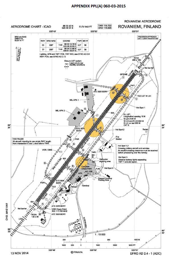
8 40 Approximately how many kilometres are in 70 nautical miles? 135 km. 145 km. 140 km. 130 km. 41 The distance of 1 statute mile is equal to: 1,852 m. 1,111 m. 1,609 m. 1,432 m. 42 How many kilometres are in 50 SM (statute miles)? Little less than 75 km. Exactly 100 km. Approximately 92 km. Approximately 80 km. 43 On a chart, 6 cm represents the distance 15 km. What is the scale of the chart? 1 : : : : The scale of the chart is 1: How many centimetres represents the distance 105km? 21.0 cm cm cm cm. 45 For this question use appendix PPL(A) What is the scale of the chart? 1 : : : : The scale of the chart is 1: How many centimetres represents the distance 54km? 36 cm. 1.8 cm. 7 cm. 18 cm. 8
9 47 The scale of the chart is 1: How many centimetres represents the distance 210km? 7cm. 63cm. 70cm. 6,3cm. 48 The scale of the chart is 1: How many centimetres represents the distance 100 NM? 31 cm cm 37 cm 49 The distance between the points ALFA and BRAVO is 107 NM. If an aircraft covers first 16 NM in 10 minutes, what time does it take to travel the entire route ALFA-BRAVO with the same groundspeed? 1 hour and 1 minute. 1 hour and 3 minutes. 1 hour and 6 minutes. 59 minutes. 50 How far will an aircraft travel with 32 gal of usable fuel with fuel consumption 7,1 gal/h at the groundspeed 108 kts? (Allow 1-hour final reserve fuel) 487 NM. 379 NM. 420 NM. 384 NM. 51 How far will an aircraft travel with 27 gal of usable fuel with fuel consumption 6,8 gal/h at the groundspeed 93 kts? (Allow 6-gallons final reserve fuel) 287 NM. 308 NM. 292 NM. 301 NM. 52 How many gallons of usable fuel should be on board of an aircraft for a distance flight of 300 NM at the groundspeed 120 kts and average fuel consumption 7,3 gal/h? (Allow 1-hour fuel reserve) gal gal gal gal. 9
10 53 A distance in meters could be converted to feet using the formula: m x 0.3. (m : 10) x 3. (m x 3) : 10. (m x 3) + 10%. 54 An altitude meters is approximately: ft ft ft ft. 55 On a chart we read the obstacle altitude 275 meters. Regarding the rule of height clearance feet over obstacles, what is the lowest altitude for overflying the obstacle? 2,230 ft. 2,130 ft. 1,230 ft. 1,900 ft. 56 Altitude ft is approximately: 1,200 m. 3,000 m. 12,000 m. 1,800 m. 57 Approximately what QNH pressure corresponds to the QFE pressure 1000 hpa on an airfield with the elevation 200 meters? 1035 hpa. 985 hpa. 990 hpa hpa. 58 What does a measuring unit knot used in aviation mean? Km/h. SM/h. NM/h. m/h. 59 The wind velocity of 10 m/sec approximately equals to: 40 kts. 20 kts. 2,5 kts. 5 kts. 10
11 60 Wind velocity 5 kts is approximately: 20 m/sec. All answers are correct. 10 km/hour. 5 statue miles/ hour. 61 A velocity 120 km/h, expressed in knots, is: 65 kts. 50 kts. 58 kts. 60 kts. 62 If a vertical speed indicator of a towing airplane shows 500 ft/min, the approximately aerotow's rate-of-climb in meters-per-second is: 3,5 m/sec. 1,5 m/sec. 2,5 m/sec. 5 m/sec. 63 What is the ground speed (GS) of an aircraft, covering in 40 minutes the distance, that represents 10.8 cm on an 1: chart? 81 kts. 100 km/h. 81 km/h. 100 mph. 64 An aircraft would cover a 120 km distance in no wind condition in 2 hours and 40 minutes, however in actual meteo conditions the flight lasted 3 hours and 5 minutes. What was the wind component along track? 16 kts tailwind. 16 km/h headwind. 6 kts tailwind. 6 km/h headwind. 65 The distance of the route from the point X to the point Y via the control point Z is 84 km. If an aircraft covers the first segment X-Z (35 km) in 50 minutes, what will be the total time of flight between the points X and Y? 45 minutes. 2 hours. 1 hour and 10 minutes. 50 minutes. 11
12 66 How far will an aircraft travel in 2 minutes and 30 seconds with a groundspeed of 98 knots? 4,08 NM. 3,35 NM. 2,55 NM. 2,45 NM kg is how many pounds? 220 lbs. 250 lbs. 180 lbs. 200 lbs pounds is how many kilograms? 41 kg. 45 kg. 52 kg. 37 kg US gallons is how many liters? 95 l. 98 l. 100 l. 105 l. 70 What is the meaning of the term "drift angle" in navigation? The difference between an angle under wind blows to the vector of an actual true air speed and a direction of an aircraft's longitudinal axis. The difference between a magnetic course and a wind direction. The difference between a direction of the true air speed of an aircraft and a desired track. The angle between an aircraft's longitudinal axis and an actual path. 71 A Wind Correction Angle is the angle difference between: Magnetic and compass heading in no wind condition. True heading and desired true course. Desired true and desired magnetic course. True and magnetic heading. 72 Which azimuth corresponds to the general direction WNW?
13 73 Which parameter is included in the reckoning of a magnetic course? Magnetic inclination. Wind correction angle. Compass deviation. Magnetic variation. 74 The angle between a direction toward geographic north and a direction toward magnetic north is called: Convergency of meridians. Inclination. Compass deviation. Variation. 75 The magnetic variation value of a given point on the Earth's surface can be obtained by: Calculating the angular difference between the meridian of a given point and the Greenwich meridian. Referring to the table of magnetic variation in the cockpit. Calculating the difference between magnetic and compass heading. Referring to the isogonic lines on aeronautical charts. 76 Lines on geographical charts joining points of equal magnetic variation, are called: Agonic lines. Izobars. Izoclinic lines. Izogonic lines. 77 Lines on geographical charts joining points of a zero magnetic variation, are called: Izogonic lines. Agonic lines. Aclinic lines. Izoclinic lines. 78 When calculating magnetic direction from a given true direction, westerly variation should be: Added. Multiplicated. Divided. Subtracted. 13
14 79 Magnetic course is calculated using the equation: True course plus/minus magnetic variation. Magnetic heading plus/minus compass deviation. True heading plus/minus magnetic variation. True course plus/minus compass deviation. 80 Magnetic heading is: True course plus/minus deviation. True heading plus/minus variation. Magnetic course plus/minus deviation. True course plus/minus variation. 81 Is it possible for a desired true track, true heading and actual true track to have the same value? No, in no case. Yes, because these values are always equal. Yes. This is possible only when flying in north or south direction. 82 To use an VHF/DF facilities for assistance in location an aircraft's position, the aircraft must have a: 4096-code transponder. VHF transmitter and receiver. VOR receiver and DME. ILS transmitter 83 An NDB normally transmits on which frequency band? 190 to 535 KHz. 400 to 1020 Hz. 962 to 1213 MHz. 200 to 415 Hz. 84 As shown by ADF A, the relative bearing TO the station is (see PPL(A) ): As shown by ADF B, the relative bearing TO the station is (see PPL(A) ):
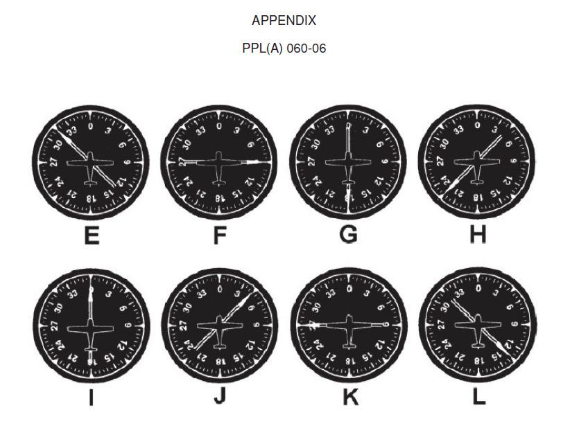
15 86 As shown by ADF D, the relative bearing TO the station is (see PPL(A) ): As shown by ADF E, the relative bearing TO the station is (see PPL(A) ): As shown by ADF F, the relative bearing TO the station is (see PPL(A) ): As shown by ADF G, the relative bearing TO the station is (see PPL(A) ): As shown by ADF A, the magnetic bearing TO the station is (see PPL(A) ): If receiving ADF indication B, what magnetic heading should the aircraft be turned to fly directly to the NDB station? (see PPL(A) ): If receiving ADF indication B, what approximate magnetic heading should the aircraft be turned to intercept the 180 bearing TO the station? (see PPL(A) ):
16 93 If an ADF indicator in the cockpit corresponds to the figure C, the magnetic bearing FROM the station is (see PPL(A) ): Which of the figures corresponds to an ADF indicator of an aircraft, flying TO the station with a right crosswind? (see PPL(A) ): A. B. D. C. 95 What is the magnetic bearing FROM the station of an aircraft with an ADF indication, depicted in figure A? (see PPL(A) ): On a magnetic heading of 320 and with an ADF indication as figure H, the magnetic bearing TO the station is (see PPL(A) ): On a magnetic heading of 035 and with an ADF indication as figure I, the magnetic bearing TO the station is (see PPL(A) ): On a magnetic heading of 120 and with an ADF indication as figure J, the magnetic bearing TO the station is (see PPL(A) ):
17 99 If the magnetic bearing of an aircraft TO the station is 240, what is the magnetic heading if the ADF indicator corresponds to the figure J? (see PPL(A) ): If the magnetic bearing of an aircraft TO the station is 030, what is the magnetic heading if the ADF indicator corresponds to the figure K? (see PPL(A) ): If the magnetic bearing of an aircraft TO the station is 135, what is the magnetic heading if the ADF indicator corresponds to the figure L? (see PPL(A) ): VOR radials are: Relative bearings. Magnetic directions. True directions. Compass directions. 103 When using a VOR for navigation, station passage is indicated: By the first complete reversal of the TO-FROM indicator. When the OFF flag appears. When the first full-scale deflection of the CDI. When the TO-FROM flag begins to flicker. 104 Which situation would result in reverse sensing of a VOR receiver? Setting the OBS to a bearing that is 90 from the bearing on which the aircraft is located. Failing to change the OBS from the selected inbound course to the outbound course after passing the station. Selecting an ILS frequency in the VOR-receiver. Flying a heading that is reciprocal to the bearing selected on the OBS. 17
18 105 To track outbound on the 180 radial of a VOR station, the recommended procedure is to set the OBS to: 180 and make heading corrections away from the CDI needle. 180 and make heading corrections toward the CDI needle. 360 and make heading corrections toward the CDI needle. 360 and make heading corrections away from the CDI needle. 106 To track inbound on the 215 radial of a VOR station, the recommended procedure is to set the OBS to: 035 and make heading corrections away from the CDI needle. 215 and make heading corrections away from the CDI needle. 035 and make heading corrections toward the CDI needle. 215 and make heading corrections toward the CDI needle. 107 With a VOR/ILS receiver set to a VOR frequency, how many degrees does full deflection of a CDI to one side represent? An aircraft 60 miles from a VOR station has a CDI indication one-fifth deflection, this represents a course centerline deviation of approximately: 6 miles. 1 mile. 3 miles. 2 miles. 109 Which airplane(s) correspond(s) to the VOR indicator V? (see PPL(A) ) Airplanes 1 and 3. Airplane 2 only. Airplane 6 only. Airplanes 5 and Which airplane(s) correspond(s) to the VOR indicator X? (see PPL(A) ) Airplanes 1 and 3. Airplanes 3 and 7. Airplane 7 only. Airplanes 1 and 2. 18
19 111 Which airplane(s) correspond(s) to the VOR indicator U? (see PPL(A) ) Airplane 5 only. Airplane 2 only. Airplane 6 only. Airplanes 1 and Which presentation of a VOR indicator corresponds to airplanes 8? (see PPL(A) ) T. W. U. V. 113 Which presentation of a VOR indicator corresponds to airplanes 5 and 7? (see PPL(A) ) U and Z. V and X. W and Z. T and X. 114 Which of the following statements, regarding a DME operation, is correct? DME can only show distance to the station set as the active frequency in the receiver. The frequency of a DME receiver in the aircraft is being adjusted automatically when we set a VOR or ILS frequency. If we move the DME switch in the cockpit to HOLD, all readings are reset to zero. When flying directly above the DME facility, the pilot reads on the DME indicator in the cockpit a zero distance. 115 Which distance is displayed by a DME indicator? Slant-range distance in statute miles. The horizontal distance along ground from the aircraft to the DME station. Slant-range distance in nautical miles. The distance from the aircraft to a point at the same altitude directly above the DME ground facility. 116 What is the DME reading if an aircraft is directly over a VOR/DME station at the altitude of ft AGL? 0. 0, ,3. 19
20 117 The slant-range error of a DME is greatest at: High altitudes and high range from the facility. Low altitudes directly over the facility. High altitudes directly over the facility. Low altitudes and high range from the facility. 118 See appendix PPL(A) Altitudes and elevations are in? SFT Km Meters Feet 119 Waypoints data in a GPS database (with the exception of users waypoints) could be updated by: A pilot, however when in-flight only. A respective software house only. A Part-145 licenced maintenance facility only. A pilot on ground only, when the device is stationary. 120 A CDI deviation needle on the GPS electronic screen in the cockpit shows a deviation from the desired track in: Arc degrees. Time units. Arc degrees or distance units, depends on pilot's discretion. Distance units. 121 When working with a GPS one must know that: It is necessary to type in manually geographic coordinates of the aircraft's parking position. The device is able to determine navigational parameters relative only to those fixes, which are in a theoretical sight of view. It is necessary to type in manually geographic coordinates of the aircraft's starting point. The information of the device is purely directional and it should not be used as primary radio navigation equipment. 122 Which map datum should be selected at GPS initialization if flying in Finland? WGS84. EUROPE. NAD83. EUREF-FIN. 20
21 123 Which velocity is measured in principle by every GPS instrument? Vertical Speed. True Air Speed. Wind Speed. Ground Speed. 124 Meridians: Are parallel to each other. Creates squares with parallel of latitudes. Are either northern or southern. Are right-angled with parallel of latitudes. 125 The scale of the chart is 1: How many centimeters represents the distance 5km? 1.0 mm. 1.0 cm. 2.5 cm. 0.5 cm. 126 In Helsinki-Malmi (EFHF) runway 18 is in use, wind 210 / 20 kts. What is the crosswind component? 10 kts. 20 kts. 5 kts. 15 kts. 127 It's on Christmas Eve in Finland, what is the Co-ordinated Universal Time (UTC)? True course is 055, wind 310 / 25 kts, variation 6 W and aircraft is flying with a true airspeed of 113 kts. What is the magnetic course?
22 129 True course is 040, wind 310 / 25 kts, variation 6 W and aircraft is flying with a true airspeed of 113 kts. What is the ground speed? 118 kts. 106 kts. 120 kts. 110 kts. 130 Which of the following geographic coordinates is incorrect? 23 46'S 'W 'S 'W 'N 'E 'N 'E. 131 True course is 125, wind 010 / 25 kts, true airspeed 95 kts and variation 5 E. What are the magnetic course and the ground speed? 106 and 103 kts. 096 and 83 kts. 113 and 83 kts. 096 and 103 kts. 132 A velocity 37 km/h, expressed in knots, is: 32,5 kts. 20 kts. 6,7 kts. 54 kts. 133 What is the total flight time when aircrafts ground speed is 106 kts and the distance is 216 NM. 2h 56min. 3h 24min. 2h 02min. 29min. 134 It's in the summer in Finland, what is the Co-ordinated Universal Time (UTC)?
23 135 In degrees South-East is: Which of the following is incorrect? 315 = North-West. 235 = South-West. 000 = North. 360 = North. 137 Finland is located between: 50 and 60 degrees eastern longitude. 60 and 70 degrees northern latitude. 60 and 70 degrees eastern longitude. 50 and 60 degrees northern latitude. 138 How many degrees does the Earth rotate in 24 hours? A velocity 100 mph is approximately: 80 km/h. 185 km/h. 160 km/h. 120 km/h. 140 What colour represents fields on the aviation chart? Orange. White. Green. Brown. 141 Magnetic heading consists of: True course and variation. Wind correction angle and deviation. Wind correction angle and variation. True course, wind correction angle and variation. 23
24 142 What does the letter P means on the aviation chart? Prohibited Area. Parking place. Low flying area. Danger area. 143 TAS is 80 kts, the wind correction angle is +19 and headwind component is 20 kts. What is the ground speed? 62 kts. 50 kts. 56 kts. 82 kts. 144 TC 180, TAS 80 kts, wind 090 / 15 kts, variation 8 E. What is the wind correction angle? TC 260, TAS 90 kts, wind 360 / 25 kts, variation 8 E. What is the ground speed? 101 kts. 81 kts. 91 kts. 95 kts. 146 TC 120, TAS 75 kts, wind 140 / 10 kts, variation 8 E. What is the magnetic course? There is no correct answer

25 25 LAPL(A)/PPL(A) question bank Rev
26 1
27 2
28 3
29 4
30 5
31 6
NAVIGATION (1) GENERAL NAVIGATION
 GENERAL NAVIGATION") 1 Which is the highest latitude listed below at which the sun will rise above the horizon and set every day? A 68 B 66 C 62 D 72 2 An aircraft flies a great circle track from 56 N 070 W to 62 N 110 E.
1 Which is the highest latitude listed below at which the sun will rise above the horizon and set every day? A 68 B 66 C 62 D 72 2 An aircraft flies a great circle track from 56 N 070 W to 62 N 110 E.
Navigation. Longitude and Latitude Foundations of Navigation. MTPs:
 Navigation 3.01 Foundations of Navigation References: FTGU pages 177-178, 184-190 Transport Canada Study and Reference Guide Glider Pilot Canada Flight Training Manual Pilot Navigation http://en.wikipedia.org/wiki/transverse_mercator_projection#spherical_transverse_mercator
LONGITUDE AND LATITUDE. Semi great circles joining the true or geographic poles of the earth (true meridians).
.") MERIDIANS OF LONGITUDE LONGITUDE AND LATITUDE Semi great circles joining the true or geographic poles of the earth (true meridians). They are measured from 0 to 180 degrees East and West of the PRIME MERIDIAN,
MERIDIANS OF LONGITUDE LONGITUDE AND LATITUDE Semi great circles joining the true or geographic poles of the earth (true meridians). They are measured from 0 to 180 degrees East and West of the PRIME MERIDIAN,
NAVIGATION THEORY QUESTIONS Basics of Navigation
 NAVIGATION THEORY QUESTIONS Basics of Navigation Q610065 look at it The angle between the plane of the ecliptic and the plane of equator is approx? 23.5 degrees In which two months of the year is the difference
JAA Administrative & Guidance Material Section Five: Licensing, Part Two: Procedures
 060 00 00 00 NAVIGATION details and associated Learning Objectives ATPL CPL ATPL/ ATPL CPL 061 00 00 00 GENERAL NAVIGATION 061 01 00 00 BASICS OF NAVIGATION 061 01 01 00 The solar system 061 01 01 01 Seasonal
ABF Pilot Training Manual. Part 8. Navigation (NAV)
") ABF Pilot Training Manual Part 8 Navigation (NAV) Version 1 May 2006 IMPORTANT ABF Inc. All rights reserved. Except for personal non-commercial purposes, no part of this publication may be reproduced by
ABF Pilot Training Manual Part 8 Navigation (NAV) Version 1 May 2006 IMPORTANT ABF Inc. All rights reserved. Except for personal non-commercial purposes, no part of this publication may be reproduced by
JAA Administrative & Guidance Material Section Five: Licensing, Part Two: Procedures
 INTRODUCTION General Navigation is divided into five main areas. It starts with the form of the earth examining direction, distance and time, and ends with looking at the latest flight management systems
ROYAL CANADIAN AIR CADETS PROFICIENCY LEVEL FOUR INSTRUCTIONAL GUIDE SECTION 1 EO M DEFINE AIR NAVIGATION TERMS PREPARATION
 ROYAL CANADIAN AIR CADETS PROFICIENCY LEVEL FOUR INSTRUCTIONAL GUIDE SECTION 1 EO M437.01 DEFINE AIR NAVIGATION TERMS Total Time: 60 min PREPARATION PRE-LESSON INSTRUCTIONS Resources needed for the delivery
FLIGHT INSTRUMENTS. This manual is dedicated only for IVAO Network activities. This document must not be used in real aviation or in others networks.
 FLIGHT INSTRUMENTS 1. Introduction The flight instruments are the instruments in the cockpit of an aircraft that provide the pilot with flight parameters. The flight instruments are used in conditions
A map is a small-scale flat-surface representation of some portion of the earth s surface.
 MAPS AND CHARTS A map is a small-scale flat-surface representation of some portion of the earth s surface. A representation that is designed for plotting navigational information is called a chart. Often
LATITUDES AND LONGITUDES
 NAME SCHOOL INDEX NUMBER DATE LATITUDES AND LONGITUDES KCSE 1989 2012 Form 4 Mathematics Answer all the questions 1. 1989 Q18 P1 A globe representing the earth has a radius 0.5m. Points A(10 0 W), B (0
Cartesian Coordinates Need two dimensional system 2 number lines perpendicular to each other X-axis is horizontal Y-axis is vertical Position relative
 General Physical Science Chapter 15 Place and Time Space and Time Einstein Space and time related Single entity Time is the 4 th dimension! Cartesian Coordinates Need some system to tell us where something
Gleim Private Pilot FAA Knowledge Test 2015 Edition, 1st Printing Updates July 2015
 Page 1 of 6 Gleim Private Pilot FAA Knowledge Test 2015 Edition, 1st Printing Updates July 2015 NOTE: Deleted text is displayed with a line through it. New text is shown with a blue background. If you
Geographic Grid -Latitudes and Longitudes
 GEOGRAPHY STD 9 Geographic Grid -Latitudes and Longitudes 2018-2019 Q1. Define Geographic Grid. The network of latitudes and longitudes are known as Geographic Grid. They help us to locate places on the
Module 2: Mapping Topic 2 Content: Determining Latitude and Longitude Notes
 Introduction In order to more easily locate points on a globe or map, cartographers designed a system of imaginary vertical lines (also called parallels) and horizontal lines (also called meridians) that
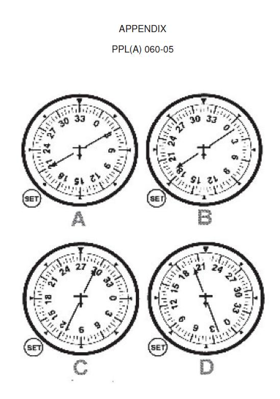
Chapter 3 Models of the Earth. 3.1 Finding Locations on the Earth. 3.1 Objectives
 Chapter 3 Models of the Earth 3.1 Finding Locations on the Earth 3.1 Objectives Explain latitude and longitude. How can latitude and longitude be used to find locations on Earth? How can a magnetic compass
Your pressure altitude is FL55, the QNH is 998, and the SAT is +30C. What is Density Altitude? Correct answer : 8620 feet
 General Navigation Your pressure altitude is FL55, the QNH is 998, and the SAT is +30C. What is Density Altitude? Correct answer : 8620 feet You leave A to fly to B, 475 nm away, at 1000 hours. Your ETA
HEIGHT ALTITUDE FLIGHT LEVEL
 HEIGHT ALTITUDE FLIGHT LEVEL 1. Definition There are several ways to indicate the vertical position of aircraft and/or obstacles; each has another meaning and is used in a particular situation: 2. Units
Geographic coordinate systems
 1 Geographic coordinate systems In this chapter you ll learn about longitude and latitude. You ll also learn about the parts that comprise a geographic coordinate system including Spheres and spheroids
1. Label a few examples of lines of latitude and lines of longitude on the globe above left.
 Oceanography 2 Location, Direction, and Distance on Nautical Charts Please read Appendix III in the textbook for reference. Learning Objectives for the first nautical chart Lab 1. Use the latitude-longitude
ASTRONOMICAL NAVIGATION
 Basic terms ASTRONOMICAL NAVIGATION *astronomical navigation *compilation *astronomical tabels *celestial observations *solution of a sight * Sun/Moon/star sight *spherical trigonometry *PZX triangle *celestial
CHAPTER 20 SIGHT REDUCTION
 CHAPTER 20 SIGHT REDUCTION BASIC PRINCIPLES 2000. Introduction Reducing a celestial sight to obtain a line of position consists of six steps: 1. Correcting sextant altitude (hs) to obtain observed altitude
Charts and Chart Work with Poole Sailing
 with Poole Sailing Nautical charts are a mine of information but they need to be up to date. Corrections to charts are published by the Hydrographic Office monthly as Notices to Mariners both in print
Latitude and Longitude Pre Test
 Name Date Latitude and Longitude Pre Test Multiple Choice Directions: For questions, 1 10 circle the answer that letter that best answers the question. Each question is worth 1 point each. 1. To locate
The Earth is a Rotating Sphere
 The Earth is a Rotating Sphere The Shape of the Earth Earth s Rotation ( and relative movement of the Sun and Moon) The Geographic Grid Map Projections Global Time The Earth s Revolution around the Sun
Aviation Maps: Aviation Maps: Chapter Ten. Chapter Ten. The Art of the Chart. The Art of the Chart. Page J1. The Lambert Conformal Conic Projection
 Page J1 Chapter Ten Chapter Ten viation Maps: viation Maps: The rt of the Chart The rt of the Chart The Lambert Conformal Conic Projection 1. [J2/Figure 1] When drawing lines on a Lambert Conformal Conic
061 GENERAL NAVIGATION
 061 GENERAL NAVIGATION JAR-FCL 060 00 00 00 NAVIGATION 061 00 00 00 GENERAL NAVIGATION 061 01 00 00 BASICS OF NAVIGATION 061 01 01 00 The Solar System 061 01 02 00 The Earth Define the terms Declination,
THE EARTH AND ITS REPRESENTATION
 UNIT 7 THE EARTH AND ITS REPRESENTATION TABLE OF CONTENTS 1 THE EARTH AND THE SOLAR SYSTEM... 2 2 THE EARTH S MOVEMENTS... 2 2.1 Rotation.... 2 2.2 The revolution of the Earth: seasons of the year....
THE EARTH. MERIDIANS AND PARALLELS
 THE EARTH. MERIDIANS AND PARALLELS 1=Circle of latitude 2=Meridian (geography) A circle of latitude, on the Earth, is an imaginary east-west circle connecting all locations (not taking into account elevation)
Abbildung 7.1: Info-Screen with status indicators and UTC time
 Tra c Display 7 No tra c received If there is no tra c in range / received, Butter y Displays show a special information screen with an UTC Clock and information about GPS and FLARM system status of the
Background Information
 Oceanography LAB #1: Marine Charts and Navigation Background Information Latitude and Longitude A coordinate is an address a means of designating location. Most coordinate systems involve a network of
4 Solar System and Time
 4 olar ystem and Time 4.1 The Universe 4.1.1 Introduction The Universe consists of countless galaxies distributed throughout space. The bodies used in astro navigation belong to the Galaxy known as the
Shape e o f f the e Earth
 1 Coordinate Systems & Projections Coordinate Systems Two map layers are not going to register spatially unless they are based on the same coordinate system. 2 Contents Shape of the earth Datum Projections
1. Geospatial technology rarely links geospatial data to nonspatial data. a. True *b. False
 Chapter 2 Where in the Geospatial World Are You? 1. Geospatial technology rarely links geospatial data to nonspatial data. 2. For geospatial technology to work, every location on Earth must be: a. inhabited
Marine Navigation Pt. 1. Marine Navigation Pt. 2
 Marine Navigation Marine Navigation Pt. 1 Introduction to Navigation Coordinate Systems Nautical Charts Aids to Navigation Tides Marine Navigation Pt. 2 The Magnetic Compass Obtaining a Fix Dead Reckoning
Test Bank Chapter 2: Representations of Earth
 Multiple Choice Test Bank Chapter 2: Representations of Earth 1. A rhumb line on a Mercator projection is a line of. a. true size b. true shape c. true compass bearing d. true location 2. Maximum longitude
CHAPTER 24 THE SAILINGS
 CHAPTER 24 THE SAILINGS INTRODUCTION 2400. Introduction Dead reckoning involves the determination of one s present or future position by projecting the ship s course and distance run from a known position.
Airplane Instruments 1.1 COMPASS ERRORS compass deviation. acceleration/deceleration error compass turning error
 Airplane Instruments 1.1 COMPASS ERRORS 1. During taxi, you should check your compass to see that it is swinging freely and indicating known headings. 2. The difference between direction indicated by a
ROYAL CANADIAN AIR CADETS PROFICIENCY LEVEL FOUR INSTRUCTIONAL GUIDE SECTION 4 EO C USE A VISUAL FLIGHT RULES (VFR) NAVIGATION CHART (VNC)
 NAVIGATION CHART (VNC)") ROYAL CANADIAN AIR CADETS PROFICIENCY LEVEL FOUR INSTRUCTIONAL GUIDE SECTION 4 EO C437.02 USE A VISUAL FLIGHT RULES (VFR) NAVIGATION CHART (VNC) Total Time: 60 min PREPARATION PRE-LESSON INSTRUCTIONS Resources
ROYAL CANADIAN AIR CADETS PROFICIENCY LEVEL FOUR INSTRUCTIONAL GUIDE SECTION 4 EO C437.02 USE A VISUAL FLIGHT RULES (VFR) NAVIGATION CHART (VNC) Total Time: 60 min PREPARATION PRE-LESSON INSTRUCTIONS Resources
Complete the following: a. Lines of latitude are parallel to the equator. Name:
 Name: Date: Social Studies Introduction: Basic Geography Period: Latitude Latitude is defined as a measurement of distance in degrees north and south of the equator. The word latitude is derived from the
APPENDIX A GLOSSARY. Appendix A.1
 APPENDIX A GLOSSARY Appendix A.1 Appendix A.2 Back Bearing A back bearing is measured from the object to your position. It is the exact opposite of a direct bearing. Base Line An imaginary line on the
NAVIGATION READER 10th edition October 2015
 NAVIGATION READER 10 th edition 13-18 October 2015 TABLE OF CONTENTS 1. Introduction p. 3 2. The earth p. 4 A layout of the earth p. 4 Latitude and longitude p. 4 3. The sea chart p. 6 Determining latitude
Fundamentals of Satellite technology
 Fundamentals of Satellite technology Prepared by A.Kaviyarasu Assistant Professor Department of Aerospace Engineering Madras Institute Of Technology Chromepet, Chennai Orbital Plane All of the planets,
ANNEX 23 RESOLUTION MSC.231(82) ADOPTION OF AMENDMENTS TO THE EXISTING MANDATORY SHIP REPORTING SYSTEM IN THE GULF OF FINLAND
 ADOPTION OF AMENDMENTS TO THE EXISTING MANDATORY SHIP REPORTING SYSTEM IN THE GULF OF FINLAND") RESOLUTION MSC.231(82) (adopted on 5 December 2006) ADOPTION OF AMENDMENTS TO THE EXISTING MANDATORY SHIP REPORTING SYSTEM IN THE GULF OF FINLAND THE MARITIME SAFETY COMMITTEE, RECALLING Article 28(b)
RESOLUTION MSC.231(82) (adopted on 5 December 2006) ADOPTION OF AMENDMENTS TO THE EXISTING MANDATORY SHIP REPORTING SYSTEM IN THE GULF OF FINLAND THE MARITIME SAFETY COMMITTEE, RECALLING Article 28(b)
A unit vector in the same direction as a vector a would be a and a unit vector in the
 In the previous lesson we discussed unit vectors on the positive x-axis (i) and on the positive y- axis (j). What is we wanted to find other unit vectors? There are an infinite number of unit vectors in
OCN 201 LAB FALL 2003 POLYNESIAN AND WESTERN NAVIGATION
 Name: OCN 201 LAB FALL 2003 POLYNESIAN AND WESTERN NAVIGATION INTRODUCTION People have been sailing the seas for thousands of years, during most of which time they relied on the sun and the stars to navigate
What is a map? A Map is a two or three-dimensional model or representation of the Earth s surface. 2-Dimensional map
 What is a map? A Map is a two or three-dimensional model or representation of the Earth s surface. 2-Dimensional map What is a Map Projection? Planar Projection Projection A Projection is a mathematical
Answer Key. Page 1 of 5
 Answer Key Name: Score: [1] When telephoning a weather briefing facility for preflight weather information, pilots should state A. whether they intend to fly VFR only. B. the full name and address of the
Coastal Navigation Pt. 1. Coastal Navigation Pt. 2
 Coastal Navigation Pt. 1 Introduction to Navigation Coordinate Systems Nautical Charts Aids to Navigation The Magnetic Compass Coastal Navigation Pt. 2 Tides Obtaining a Fix Dead Reckoning Navigation Rules
Geography Class 6 Chapters 3 and
 CHAPTER 3 MOTIONS OF THE EARTH The Earth is always travelling in Space. That makes each person on Earth, a Space Traveller. No one feels the movement of the Earth because humans are too tiny when compared
MOTIONS OF THE EARTH. Figure 3.1 : Inclination of the Earth s axis and the orbital plane. Figure 3.2 : Day and Night on the Earth due to rotation
 3 Let s Do Take a ball to represent the earth and a lighted candle to represent the sun. Mark a point on the ball to represent a town X. Place the ball in such a way that the town X is in darkness. Now
1. For Cosine Rule of any triangle ABC, b² is equal to A. a² - c² 4bc cos A B. a² + c² - 2ac cos B C. a² - c² + 2ab cos A D. a³ + c³ - 3ab cos A
 1. For Cosine Rule of any triangle ABC, b² is equal to A. a² - c² 4bc cos A B. a² + c² - 2ac cos B C. a² - c² + 2ab cos A D. a³ + c³ - 3ab cos A 2. For Cosine Rule of any triangle ABC, c² is equal to A.
Global Wind Patterns
 Name: Earth Science: Date: Period: Global Wind Patterns 1. Which factor causes global wind patterns? a. changes in the distance between Earth and the Moon b. unequal heating of Earth s surface by the Sun
Lesson 20: The Earth in its Orbit
 291 Lesson 20: The Earth in its Orbit Recall that the Earth s orbit around the un is an ellipse which is almost a perfect circle. The average distance from the un to the Earth is 152,100,000 km (to the
Spherical Geometry HSC. Name:
 Spherical Geometry HSC Name: C:\Documents and Settings\tracey_h-butters\Desktop\mathematics\year_levels\math_stage6\General\hsc\spherical_geometry\spherical_geo_notes.doc 1 HSC CAPACITY MATRIX GENERAL
Pipistrel ALPHA Trainer
 Pipistrel ALPHA Trainer Operators Manual for the LX Instrument Suite Fitted to the Pipistrel ALPHA Trainer with Air Data, Engine Monitoring and AHRS Revision 3 Page 1 of 5 ALPHA Trainer Panel Layout EMSIS
Altitude. Area. surface inside closed boundaries measured in squares. Area is 21 squares. height above sea level or the Earth s surface
 Altitude L 6 height above sea level or the Earth s surface Cruising altitude is 30,000 feet. Area surface inside closed boundaries measured in squares Area is 21 squares L 4 Axis plural Axes 2 intersecting
Compass Basics. Quick Map Basics Review For Compass Use
 Compass Basics Quick Map Basics Review For Compass Use A topographic map tells you where things are and how to get to them, whether you're hiking, biking, hunting, fishing, or just interested in the world
EnvSci360 Computer and Analytical Cartography
 EnvSci360 Computer and Analytical Cartography Lecture 3 Geodesy Map Projections, Datums, and Coordinate Systems 1 Geodesy The science of measuring and representing the shape and size of the earth, and
FLIGHT INSTRUMENTS TYPICAL QUESTIONS
 FLIGHT INSTRUMENTS TYPICAL QUESTIONS JANUARY 2004 TYPICAL QUESTIONS FLIGHT INSTRUMENTS PAGE 1 of 76 1. If the pitot Head and Static Vent were blocked by ice, the instruments that would be affected are:
Earth s Orbit. Sun Earth Relationships Ridha Hamidi, Ph.D. ESCI-61 Introduction to Photovoltaic Technology
 1 ESCI-61 Introduction to Photovoltaic Technology Sun Earth Relationships Ridha Hamidi, Ph.D. Spring (sun aims directly at equator) Winter (northern hemisphere 23.5 tilts away from sun) 2 Solar radiation
This week s topics. Week 6. FE 257. GIS and Forest Engineering Applications. Week 6
 FE 257. GIS and Forest Engineering Applications Week 6 Week 6 Last week Chapter 8 Combining and splitting landscape features and merging GIS databases Chapter 11 Overlay processes Questions? Next week
Skills Practice Skills Practice for Lesson 14.1
 Skills Practice Skills Practice for Lesson 1.1 Name Date By Air and By Sea Introduction to Vectors Vocabulary Match each term to its corresponding definition. 1. column vector notation a. a quantity that
GEOGRAPHY STD.9 LATITUDE & LONGITUDE
 GEOGRAPHY STD.9 LATITUDE & LONGITUDE 1. What is the Earth Grid? A. The complete network of meridians & parallels is called the earth Grid. 2. What is Latitude? A. The latitude of a place is the distance
Using Map and Compass Together
 Using Map and Compass Together In situations where you foresee a potential evacuation on foot, where there are no roads, and no indication as to the direction of travel (i.e., road signs), it is recommended
AIR TRAFFIC INCIDENT REPORT FORM
 Address: Rannsóknarnefnd samgönguslysa Flugvallarvegur 7, 101 Reykjavik, Iceland Telephone: +354 511 6500 Telefax: +354 511 6501 E-mail: RNSA@RNSA.is AIR TRAFFIC INCIDENT REPORT FORM For use when submitting
Contents. Section 1: Climate Factors. Section 2: Climate Types. Section 3: Climate Effects
 Contents Section 1: Climate Factors 1. Weather or Climate?.... 2 2. Elements of Climate.... 4 3. Factors Affecting Climate.... 10 4. Comparing Climates.... 15 5. Quiz 1.... 20 Section 2: Climate Types
Map Projections. Chapter 4 MAP PROJECTION
 Map Projections Chapter 4 Map Projections What is map projection? Why are map projections drawn? What are the different types of projections? Which projection is most suitably used for which area? In this
HOW TO TRAVEL ON EARTH WITHOUT GETTING LOST
 HOW TO TRAVEL ON EARTH WITHOUT GETTING LOST Using a globe to learn how a position on Earth can be described. Rui Dilão, Instituto Superior Técnico Curriculum topic latitude, longitude, coordinate system
The Earth-Moon-Sun System
 chapter 7 The Earth-Moon-Sun System section 2 Time and Seasons What You ll Learn how to calculate time and date in different time zones how to distinguish rotation and revolution what causes seasons Before
Unit 2 Math II - History of Trigonometry
 TSK # Unit Math II - History of Trigonometry The word trigonometry is of Greek origin and literally translates to Triangle Measurements. Some of the earliest trigonometric ratios recorded date back to
CHAPTER 2 A USER'S GUIDE TO THE SKY
 CHAPTER 2 A USER'S GUIDE TO THE SKY MULTIPLE CHOICE 1. Seen from the northern latitudes (mid-northern hemisphere), the star Polaris a. is never above the horizon during the day. b. always sets directly
Topic Guide: The Celestial Sphere. GCSE (9-1) Astronomy. Pearson Edexcel Level 1/Level 2 GCSE (9-1) in Astronomy (1AS0)
 Astronomy. Pearson Edexcel Level 1/Level 2 GCSE (9-1) in Astronomy (1AS0)") Topic Guide: The Celestial Sphere GCSE (9-1) Astronomy Pearson Edexcel Level 1/Level 2 GCSE (9-1) in Astronomy (1AS0) The Celestial Sphere Contents Specification Points 1 The Astronomy 2 Equatorial coordinates
Topic Guide: The Celestial Sphere GCSE (9-1) Astronomy Pearson Edexcel Level 1/Level 2 GCSE (9-1) in Astronomy (1AS0) The Celestial Sphere Contents Specification Points 1 The Astronomy 2 Equatorial coordinates
Tonight. {01} The map. Relative space. What does a map do? Types of maps GEOG 201 2/17/2010. Instructor: Pesses 1
 Tonight {01} The map What makes a map Measuring the Earth Map Interpretation & GPS Spring 2010 M. Pesses What does a map do? Shows where things are Shows spatial (topological) relationships Shows patterns,
Sunlight and its Properties Part I. EE 446/646 Y. Baghzouz
 Sunlight and its Properties Part I EE 446/646 Y. Baghzouz The Sun a Thermonuclear Furnace The sun is a hot sphere of gas whose internal temperatures reach over 20 million deg. K. Nuclear fusion reaction
Gnomon (a thin, round stick at least a foot long and capable of being put into the ground or stood up vertically)
") Name: Partner(s): Lab #3 Celestial Navigation Due 7/2 Objectives In this lab you will take measurements of the sun s motion around noon and the north star s position in the sky. You will use this data
Name: Partner(s): Lab #3 Celestial Navigation Due 7/2 Objectives In this lab you will take measurements of the sun s motion around noon and the north star s position in the sky. You will use this data
Mapping Earth s Surface Chapter 2 Section 3
 Mapping Earth s Surface Chapter 2 Section 3 Day 1 Objective I will understand maps can be used to find locations on Earth and to represent information about features on Earth s Surface I will understand
8-2 Vectors in the Coordinate Plane
 37. ROWING Nadia is rowing across a river at a speed of 5 miles per hour perpendicular to the shore. The river has a current of 3 miles per hour heading downstream. a. At what speed is she traveling? b.
DUMMIES guide to Astro-Navigation
 DUMMIES guide to Astro-Navigation The idea of this booklet is to give you the nuts and bolts in the process of gaining a position on your chart through celestial navigation without a deep understanding
Which instrument will become inoperative if the pitot tube becomes clogged?
 Gleim FAA Test Prep: Private Pilot (12 questions) Study Unit 2a [Airplane Instruments, Engines, and Systems] Name: Date: [1] Gleim #: 2.3.23 -- Source: PHAK Chap 7 (Refer to Figure 4.) Which color identifies
Map Projections. Displaying the earth on 2 dimensional maps
 Map Projections Displaying the earth on 2 dimensional maps Map projections Define the spatial relationship between locations on earth and their relative locations on a flat map Are mathematical expressions
Math 1720 Final Exam REVIEW Show All work!
 Math 1720 Final Exam REVIEW Show All work! The Final Exam will contain problems/questions that fit into these Course Outcomes (stated on the course syllabus): Upon completion of this course, students will:
Map projections. Rüdiger Gens
 Rüdiger Gens 2 Outline! Relevant terms! Why map projections?! Map projection categories " Projection surfaces " Features preserved from distortions! Map projection examples! Right choice Relevant terms!
1.1 Angles, Degrees, and Arcs
 MA140 Trig 2015 Homework p. 1 Name: 1.1 Angles, Degrees, and Arcs Find the fraction of a counterclockwise revolution that will form an angle with the indicated number of degrees. 3(a). 45 3(b). 150 3(c).
The Earth, Moon, and Sky. Lecture 5 1/31/2017
 The Earth, Moon, and Sky Lecture 5 1/31/2017 From Last Time: Stable Orbits The type of orbit depends on the initial speed of the object Stable orbits are either circular or elliptical. Too slow and gravity
Civil Air Patrol Auxiliary of the United States Air Force
 Mountain Flying Qualification Course Civil Air Patrol Auxiliary of the United States Air Force Mountain Searching ELT Searches Conduct search at highest practical altitude to increase chance of detecting
Observing the Night Sky: Locating Objects
 Observing the Night Sky: Locating Objects As I left the house this morning, there was a bright bluish light above and to the left of my neighbors house (approximately East) and a big very bright object
CHAPTER II THE COORDINATES SYSTEM AND FORMULARIES
 CHAPTER II THE COORDINATES SYSTEM AND FORMULARIES www.loxodrome.org/ Introduction to Celestial Navigation/Chapter II THE CO-ORDINATES SYSTEMS AND FORMULARIES In previous section we had a purely geometrical
SOLAR GEOMETRY (AND SOLAR RADIATION)
") SOLAR GEOMETRY (AND SOLAR RADIATION) Ball State Architecture ENVIRONMENTAL SYSTEMS 1 Grondzik 1 Solar Radiation Components glass will reflect some incoming radiation; absorb some; and transmit some SHGF
SOLAR GEOMETRY (AND SOLAR RADIATION) Ball State Architecture ENVIRONMENTAL SYSTEMS 1 Grondzik 1 Solar Radiation Components glass will reflect some incoming radiation; absorb some; and transmit some SHGF
What is a Map Projection?
 What is a Map Projection? It is how we represent a three dimensional Earth on a flat piece of paper However The process of transferring information from the Earth to a map causes every projection to distort
Welcome to Lesson 4. It is important for a GIS analyst to have a thorough understanding of map projections and coordinate systems.
 Welcome to Lesson 4. It is important for a GIS analyst to have a thorough understanding of map projections and coordinate systems. A GIS without coordinates would simply be a database like Microsoft Excel
Latitude and Longitude
 Latitude and Longitude Finding Your Location on a Sphere Coordinate Systems n When you are locating a point on a flat surface you can use Cartesian coordinates of x and y. n The point 2, 3 is plotted on
SOFTWARE. Control of the AMS SYSTEM CONTROL AND MONITORING OF AIRFIELD GROUND LIGHTING EQUIPMENT
 Control of the AMS SYSTEM SOFTWARE CONTROL AND MONITORING OF AIRFIELD GROUND LIGHTING EQUIPMENT Description of function airfield ground lighting equipment are shown on the screen representing the airport
EARTHS SHAPE AND POLARIS PRACTICE 2017
 1. In the diagram below, letters A through D represent the locations of four observers on the Earth's surface. Each observer has the same mass. 3. Which diagram most accurately shows the cross-sectional
To teach the instrument student knowledge of the elements related to an instrument takeoff and the primary instruments for pitch, bank, and power.
 INSTRMENT TAKEOFF (1.1..) OBJECTIVE To teach the instrument student knowledge of the elements related to an instrument takeoff and the primary instruments for pitch, bank, and power. COMPLETION STANDARDS
INTRODUCTION FOREWORD
 FOREWORD The Sight Reduction Tables for Air Navigation consist of three volumes of comprehensive tables of altitude and azimuth designed for the rapid reduction of astronomical sights in the air. This
UNIT 3: EARTH S MOTIONS
 UNIT 3: EARTH S MOTIONS After Unit 3 you should be able to: o Differentiate between rotation and revolution of the Earth o Apply the rates of rotation and revolution to basic problems o Recall the evidence
Chapter 6: Latitude by Noon Sight
 Chapter 6: Latitude by oon ight When the sun is crossing the meridian of the boat, it is straight south or north of the boat and at its highest altitude over the horizon for the day. The local meridian
Earth Moon Motions A B1
 Earth Moon Motions A B1 1. The Coriolis effect provides evidence that Earth (1) rotates on its axis (2) revolves around the Sun (3) undergoes cyclic tidal changes (4) has a slightly eccentric orbit 9.
REVISION: MAPWORK 18 SEPTEMBER 2014
 REVISION: MAPWORK 18 SEPTEMBER 2014 Lesson Description In this lesson we revise: Various mapwork calculations Summary Relative Position Bearing is the angular (angle) distance between two points True Bearing