GEOMATICS ENGINEERING
|
|
|
- Kristian Rodgers
- 6 years ago
- Views:
Transcription
1 GEOMATICS ENGINEERING CHAPTER 2 Direct and Indirect Distance Measurement Methods
2 Distance Measurement Methods Equipment Classification Usage Fieldwork procedure Booking system Adjustment and plotting
3 Introduction Linear measurement is the basis of all surveying. There are two main methods to measure distance: Direct method Measurements are made by tape or chain Indirect method EDM, Transit, stadia or theodolite are used
4 Types of Distances One of the fundamentals of surveying is the need to measure distance. Distances are not necessarily linear, especially if they occur on the spherical earth. We will deal with distances in geometric space, which we can consider a straight line from one point or feature to another.

5 Methods of Measuring Horizontal Distance Pacing A surveyor must walk a known distance a number of times in his natural way: accuracy = 1:50 Odometer An odometer converts the number of revolutions of a wheel of known circumference to a distance. Can be used for preliminary surveys. Odometer distance must be converted to horizontal distance when the slope of the ground is steep. Tachometry Distance is measured indirectly with the help of an optical instrument called tachometer. Theodolite can also be used with leveling staff.
 Waves are utilized to measure the")
6 Methods of Measuring Horizontal Distance Chaining Used where great precision is not required. Chains of 30 m lengths are frequently used. Taping Used for accurate work and may be o iron, or cloth Usually are 30 m in lengths Accuracy: 1:10,000 Electronic distance measurement (EDM) Waves are utilized to measure the distance. Accuracy: 1:10,000 to 1:100,000
7 Pacing
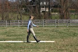
8 Tapping or Distance Measurement by Tape Equipment's Tension handles allow the user to apply a specified tensile force on the tape. Steel tapes are manufactured under fixed conditions of temperature and tensile force (30 meter tape). Tape grips: These allow the user to firmly grasp the steel tape and resist the pull of the tape from the person located on the other end of the tape. Plumb bobs: These are used to locate the tape precisely over a specified point. Chaining pins: These are used to mark tape lengths. Hand level: These are used to establish an approximate horizontal line of sight.

9 Tapping Equipment
10 General Procedure of Tapping Person A: Holds the tension handle located at the zero end of the tape. Person B: Holds the tape reel and uses a tape grip to pull the tape. Person B: Pinches the plumb bob string at a convenient point on the tape. Person A: Holds the plumb bob string along the edge of the tape above his/her intended mark. Person B: Holds the plumb bob over his/her mark. Calls out mark.mark..mark to indicate that the plumb bob is being held over the intended mark. Braces for the tension applied by person A. Person A: Does the actual pulling (10 lbf or N). Reports the tension value and the corresponding tape measurement. Person B: Reports the tape reading at his/her end of the tape.


11 Using a hand level to establish a horizontal line of sight Person B using the tape grip to hold the plumb bob over her mark (a chaining pin)

12 Person A applying 10 lb or N of tension using the tension handle while maintaining the plumb bob over the mark
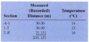
13 Measured Distance The measured length is determined by subtracting tape reading A from tape reading B. For example: Person B calls out a tape reading of Person A reports a tape reading of The measured length is computed as or meters. The measurement procedure is repeated with one important difference. Person B holds the plumb bob string at a different point on the tape. The two measured lengths are then compared. If the difference between the measurements is less than the allowable tolerance, then the average of the measured lengths between the two points can be considered accurate. If they are not, the length measurements are be repeated until two successive measurements are obtained within the allowable tolerance.
14 General Procedure of Tapping
15 Distance Measurement for Slope Surface
16 Distance Measurement for Slope Surface
17 Distance Measurement for Slope Surface
18 Tapping Corrections In general, the distance measurement obtained in the field will be in error. Errors in a distance measurement can arise from a number of sources: Instrument errors. A tape may be faulty due to a defect in its manufacturing or from kinking. Natural errors. The actual horizontal distance between the ends of the tape can vary due to the effects of: 1. temperature, 2. elongation due to tension, and 3. sagging. Personal errors. Errors will arise from carelessness by the survey crew: 1. poor alignment 2. tape not horizontal 3. improper plumbing 4. faulty reading of the tape
19 Tapping Corrections When tapes are manufactured, a standardized temperature and a standardized tension value are specified by the manufacturer. Although the standard values vary from tape to tape, typical values are T s = 20 C P s = 50 N. Corrections In the field, all your measured lengths are wrong!! A series of corrections are typically required to account for the effects of: Temperature Sagging Tension Scale (Erroneous tape length) Slope correction
20 1. Erroneous Tape Length Tape has a nominal length under certain conditions, a tape stretches with time. Standardization needs to be carried out frequently by using reference tape or baseline.
21 2. Slope Correction All plan distances are always quoted as horizontal distances L, therefore any distance not measured on the horizontal will need to be corrected for slope. Slope correction must ALWAYS be considered, and either eliminated in the field or mathematically compensated.
22 3. Tension or Pull Correction OR e pull ( P Ps ) L E x A m
23 4. Temperature Correction Most materials expand and contract with temperature change, and this effects taped distances. If a tape has stretched due to heat it will read shorter than it would at its normal (or standard) temperature. e temp L m xc ( T Ts )
24 5. Sag Correction If the tape cannot be supported for its length then it will hang freely under the influence of gravity. The shape of the tape will take is known as (sag) and can be determined mathematically.
25 Corrected Measured Length Actual length is: OR L a L m C temp( T ) Cst( L) Csag ( S ) Cslope C pull( tension) orp
26 Problem 1 A steel tape of nominal length 30 m was used to measure a line AB by suspending it between supports. The following measurements were recorded. The standardization length of the tape against a reference tape was known to be m at 20 o C and 50 N. If the tape weighs 0.17 N/m and has a cross sectional area of 2 mm 2, calculate the horizontal length of AB. Temp. correction factor = m/ o C
27 Solution to Problem 1
28 Problem 2

29 Solution to Problem 2
30 Solution to Problem 2
31 Theodolite Surveying Distance Measurement by Stadia Method
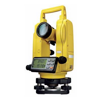
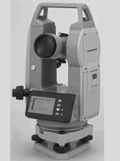
32 Introduction to Theodolite
33 Theodolite Surveying The system of surveying in which the angles are measured with the help of a theodolite, is called Theodolite surveying. In combination with Leveling Staff theodolite can also be used to measure the distance i.e. called as stadia or tachometric method of distance measurement.
34 THEODOLITE The Theodolite is a most accurate surveying instrument mainly used for : Measuring horizontal and vertical angles Locating points on a line Prolonging survey lines Finding difference of level Setting out grades Ranging curves Tachometric Survey (distance measurement)

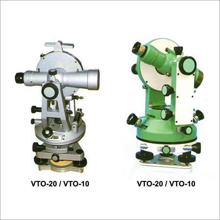
35 TRANSIT VERNIER THEODOLITE
36 TRANSIT VERNIER THEODOLITE Details of Upper & Lower Plates

37 TRANSIT VERNIER THEODOLITE
38 CLASSIFICATION OF THEODOLITES Theodolites may be classified as ; A. i) Transit Theodolite. ii) Non Transit Theodolite. B. i) Vernier Theodolites. ii) Micrometer Theodolites.
39 CLASSIFICATION OF THEODOLITES A. Transit Theodolite: A theodolite is called a transit theodolite when its telescope can be transited i.e revolved through a complete revolution about its horizontal axis in the vertical plane, whereas in a- Non-Transit type, the telescope cannot be transited. They are inferior in utility and have now become obsolete.
40 CLASSIFICATION OF THEODOLITES B. Vernier Theodolite: For reading the graduated circle if verniers are used, the theodolite is called as a Vernier Theodolite. Whereas, if a micrometer is provided to read the graduated circle the same is called as a Micrometer Theodolite.
41 Description of a Transit Vernier Theodolite A Transit vernier theodolite essentially consist of the following : 1. Leveling Head. 6. T- Frame. 2. Lower Circular Plate. 7. Plumb bob. 3. Upper Plate. 8. Tripod Stand. 4. Telescope. 5. Vernier Scale.
42 Terms Used in Manipulating a Transit Vernier Theodolite 1. Centering Centering means setting the theodolite exactly over an instrument- station so that its vertical axis lies immediately above the station- mark. It can be done by means of plumb bob suspended from a small hook attached to the vertical axis of the theodolite. The center shifting arrangement if provided with the instrument helps in easy and rapid performance of the centering. 2. Transiting Transiting is also known as plunging or reversing. It is the process of turning the telescope about its horizontal axis through in the vertical plane thus bringing it upside down and making it point, exactly in opposite direction. 3. Swinging the telescope It means turning the telescope about its vertical axis in the horizontal plane. A swing is called right or left according as the telescope is rotated clockwise or counter clockwise.
43 4. Face Left If the vertical circle of the instrument is on the left side of the observer while taking a reading, the position is called the face left and the observation taken on the horizontal or vertical circle in this position, is known as the face left observation. 5. Face Right If the vertical circle of the instrument is on the right side of the observer while taking a reading,the position is called the face right and the observation taken on the horizontal or vertical circle in this position, is known as the face right observation. 6. Changing Face It is the operation of bringing the vertical circle to the right of the observer, if originally it is to the left, and vice versa. It is done in two steps; Firstly revolve the telescope through in a vertical plane and then rotate it through in the horizontal plane i.e. first transit the telescope and then swing it through
44 7. Line of Collimation It is also known as the line of sight. It is an imaginary line joining the intersection of the cross- hairs of the diaphragm to the optical centre of the object- glass and its continuation. DIAPHRAGM LINE OF COLLIMATION 8. Axis of the telescope TELESCOPE It is also known an imaginary line joining the optical centre of the objectglass to the center of eye piece. OBJECT GLASS. AXIS OF THE TELESCOPE TELESCOPE
45 9. Axis of the Level Tube It is also called the bubble line. It is a straight line tangential to the longitudinal curve of the level tube at the center of the tube. It is horizontal when the bubble is in the center. 10. Vertical Axis It is the axis about which the telescope can be rotated in the horizontal plane. 11. Horizontal Axis It is the axis about which the telescope can be rotated in the vertical plane. It is also called the trunion axis.
46 Adjustment of a Theodolite The adjustments of a theodolite are of two kinds :- 1. Permanent Adjustments. 2. Temporary Adjustments. 1) Permanent adjustments: The permanent adjustments are made to establish the relationship between the fundamental lines of the theodolite and, once made, they last for a long time. They are essential for the accuracy of observations.
47 Adjustment of a Theodolite 2. Temporary Adjustment The temporary adjustments are made at each set up of the instrument before we start taking observations with the instrument. There are three temporary adjustments of a theodolite:- i) Centering ii) iii) Leveling Focusing

48 Centering of a Theodolite
49 Leveling of a Theodolite

50 Focusing of a Theodolite

51 Leveling Staff
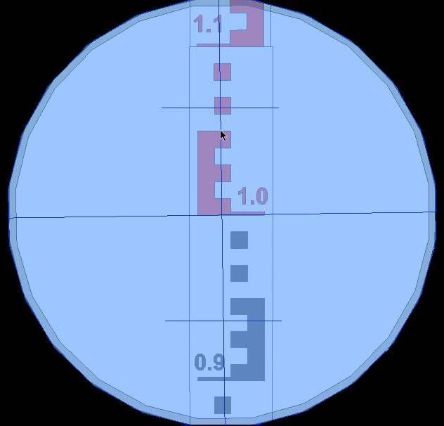
52 Stadia Stadia is a rapid method of measuring distances. Along with the center cross hairs, transits are equipped with two additional cross hairs known as stadia hairs.
 as the distance between the rod reading at the top stadia hair and the rod reading at the bottom stadia")
53 Definition sketch we can define D as the horizontal distance from the transit to the rod the stadia interval (S) as the distance between the rod reading at the top stadia hair and the rod reading at the bottom stadia hair
54 Horizontal distance When the line of sight is horizontal, the distance (D) from the instrument to the rod is given by: where K is the stadia interval factor (commonly 100) C is a constant (a property of the instrument) S is the difference in the stadia hair rod readings. Many modern transits have the following properties: K = 100 C = 0 (internal-focusing) C = 0.3 (external-focusing) It is your responsibility to check the constant values for your instrument. They are provided on the instrument case and they are not all the same.
55 Example Find the distance from the transit given the following information: K = 100 C = 0 upper stadia reading = m middle reading = m lower stadia reading = m

56 Inclined Sightings (Distance) Due to topography, many stadia shots are inclined. In other words, the line of sight associated with the transit is not horizontal.
57 Inclined Sightings (Distance) We need to modify the equation to account for the inclined line of sight The horizontal distance (H) between the transit and the rod is found using the following expression where α is the vertical angle corresponding to the line of sight note: the angle of inclination can be either positive or negative (i.e. you are shooting down a steep hill)
58 Example Let s use the same numbers as the previous example with the exception that the line of sight is inclined at an angle of 4 degrees. Find the horizontal distance from the transit given the following information: K = 100 C = 0 S = α = 4
.")
59 Vertical Distance we can define the vertical distance (V) as the distance between the rod reading and the instrument (HI). The vertical distance (V) between the rod reading and the instrument is given by:

60 Elevation of the Point finally, we are interested in computing the elevation of the location situated under the survey rod or

61 Elevation of the Point Let s finish off our example by assuming that our HI has been established to be The elevation at the corresponding point of interest would then be found using:
62 Electromagnetic Distance Measurement (EDM) 62

63 ELECTROMAGNETIC DISTANCE MEASUREMENT (EDM) 63 First introduced by Swedish physicist Erik Bergstrand (Geodimeter) in Used visible light at night to accurately measure distances of up to 40km. In 1957, the first Tellurometer, designed by South African, Dr. T.L. Wadley, was launched. The Tellurometer used microwaves to measure distances up to 80km day or night. First models bulky and power hungry, they revolutionized survey industry which, until their arrival, relied on tape measurements for accurate distance determinations. The picture above shows the remote unit of the CA1000 Tellurometer, which was used extensively in the 70 s and 80 s.
64 64 Introduction to EDM EDM instruments, as the name implies utilizes electromagnetic energy for measuring distances between two points. Electromagnetic waves can be represented in the form of periodic sinusoidal waves. The time taken for an alternating current to go through one complete cycle of values is called period of the wave. One cycle of the wave motion is completed when one period has been completed and number of cycles per unit time is called as frequency (Hertz-one cycle per sec). Wavelength (λ) = velocity of radiation (V) / f
65 Propagation of Electromagnetic Energy 65 Velocity of EM energy V = ƒ λ ƒ is the frequency in hertz (cycles/second) λ is the wavelength In vacuum the velocity of electromagnetic waves equals the speed of light. V = c/n n >1, n is the refractive index of the medium through which the wave propagates c is the speed of light = m/sec f λ = c/n or λ = c/fn Note that n in any homogeneous medium varies with the wavelength λ. White light consists of a combination of wavelengths and hence n for visible light is referred to as a group index of refraction. For EDM purposes the medium through which electromagnetic energy is propagated is the earths atmosphere along the line being measured. It is therefore necessary to determine n of the atmosphere at the time and location at which the measurement is conducted.
66 Propagation of Electromagnetic Energy The refractive index of air varies with air density and is derived from measurements of air temperature and atmospheric pressure at the time and site of a distance measurement. For an average wavelength λ: n a = 1 + ( n g -1 ) x p - 5.5e x T T Where n g is the group index of refraction in a standard atmosphere (T=0 C, p=760mm of mercury, 0.03% carbon dioxide) n g = 1+ ( /λ / λ 4 ) x 10-7 p is the atmospheric pressure in mm of mercury (torr) T is the dry bulb temperature in C and e is the vapor pressure Where e= e +de and e =4.58 x 10a, a=(7.5t )/(237.3+T ), de=-( p ( T ) (T-T ) and T is the wet-bulb temperature So measuring p, T and T will allow for the computation of n for a specific λ 66
67 Amplitude THE FRACTION OF A WAVELENGTH AND THE PHASE ANGLE r λ 180 θ 0 ½λ ½λ - r 270 ¼λ ¼λ ¼λ ¼λ θ λ 360 A fraction of a wavelength can be determined from a corresponding phase angle θ Note: For θ = 0 the fraction is 0 For θ = 90 the fraction is ¼ For θ = 180 the fraction is ½ For θ = 270 the fraction is ¾ For θ = 360 the fraction is 1 EDM INSTRUMENTS CAN MEASURE PHASE ANGLES
68 Principles of Electronic Distance Measurement If an object moves at a constant speed of V over a straight distance L in a time interval t, then L= V t = (c/n) t Knowing the speed of light c and being able to determine the refractive index, we could measure the time interval it takes for an electromagnetic wave to move from A to B to determine the distance L between A and B. But since the speed of light (c) is very high, the time interval t would need to be measured extremely accurately. Instead, the principle of EDM is based on the following relationship: A L = (m + p) λ λ λ λ λ λ λ λ λ λ λ λ λ m is an integer number of whole wavelengths, p is a fraction of a wavelength So L can be determined from λ, m and p L 68 p B

69 69 Distance Measuring by EDM How the process works can be shown using the velocity equation. Velocity = Distance Time The instrument broadcasts a focused signal that is returned by a prism or reflection from the object. Therefore, if the speed of the signal is known (speed of light), and the time for the signal to travel to the target and back is known, the distance can be calculated. Rearranging the equation for distance results in: Distance = Velocity x Time
70 70 EDM Advantages and Disadvantages Advantages of EDM s 1. Precise measurement of distance. 2. Line of sight instrument 3. Capable of measuring long distances 4. Reflector less are single person operation Disadvantages of EDM s 1. Electronic = batterers 2. Accuracy affected by atmospheric conditions. 3. Can be expensive Error ± (2 mm + 2 ppm x D)

71 Distance Measurement by Total Station 71
72 72 Distance Measurement by Total Station Point the instrument at a prism or reflector (which is vertical at the point). Push the measure button and record the distance. We can measure horizontal or slope distance, It is important to note which readings is being collected. If your are measuring the slope distance, the zenith angle must be recorded to allow the computation of horizontal distance. If you are collecting topographic data with elevations, it is important that the height of the instrument and the height of the prism be recorded.
 Natural Varying met along line Turbulence in air Remember: L = (m + p)")
73 Sources of Error in EDM: Personal: Careless centering of instrument and/or reflector Faulty temperature and pressure measurements Incorrect input of T and p 73 Instrumental Instrument not calibrated Electrical center Prism Constant (see next slide) Natural Varying met along line Turbulence in air Remember: L = (m + p) λ

74 A B C Sources of Error in EDM: Determination of System Measuring Constant 1. Measure AB, BC and AC 2. AC + K = (AB + K) + (BC + K) 3. K = AC- (AB + BC) 4. If electrical center is calibrated, K represents the prism constant. 74 Blunders: Incorrect met settings Incorrect scale settings Prism constants ignored Incorrect recording settings (e.g. horizontal vs. slope) Good Practice: Never mix prism types and brands on same project!!! Calibrate regularly!!!

75 Distance Measuring Methods--GPS 75 GPS (global Positioning System) is a system of satellites in orbit around the earth. Each satellite knows its position and uses a unique signal to continuously broadcasts this information. Along with the position information is a time signal. When a GPS receiver receives a signal from at least four (4) satellites it can compute its position by trilateration. The receiver position can be expressed in degrees of latitude and longitude, or distance (meters) using Universal Transverse Mercator (UTM) coordinates.
76 76 Distance Measuring Methods-- GPS~ cont. Because UTM distances are based on a x-y coordinate system, distances between points can be determined by simple math. Example: Determine the distance between Stillwater and Oklahoma City when the UTM coordinates for Stillwater are E & N and the UTM coordinates for Oklahoma City are E & N
77 77 Distance Measuring Methods GPS ~ Example Subtracting the coordinates gives the two sides of a right triangle. The hypotenuse of the triangle is the distance between the two towns (44.6 mi). HD = = m = 44.6 mi
78 Numerical Problems-Distance Measurement 78
79 79 Problem-1 The readings given below were made with a tachometric theodolite having a multiplying constant (K) of 100 and no additive constant (C). The reduced level at station A was m and the height of the instrument axis is 1.35 m above the ground. Calculate the gradient expressed as the horizontal distance one meter rise or fall vertically between the stations B and C. Station To Vertical angle Stadia readings A B C /1.524/ /1.356/0.600
80 80
81 81 Problem-2 A tachometric readings were taken from an instrument station A the reduced level of which was m to a staff station B. Instrument multiplying constant (K) is 100, additive constant 360 mm, staff held vertical. The height of instrument is 1.38 m and vertical angle is 30 deg. The stadia readings are 0.714, 1.007, and respectively. Calculate the horizontal and vertical distances.
82 82 Problem-3 In a line ABC, AB measures m, BC measures m and AC measures m using a particular EDM reflector combination,. A line measures m with this instrument-reflector combination. What is the correct length of the line? Solution: K = AC (AB+BC) = ( ) = Corrected length of line = (-0.158) = m
Measurement of Horizontal Distances. the distance between two points means the horizontal distance
 Measurement of Horizontal Distances the distance between two points means the horizontal distance Pacing Mechanical Devices Taping * Tachymetric Photogrammetric * Electronic Distance Measurement (EDM)
Chapter-2 Direct Measurement Indirect Measurement Method of linear measurement Taping corrections Optical measurement Tachometry EDM Measurement
 Chapter-2 Direct Measurement Indirect Measurement Method of linear measurement Taping corrections Optical measurement Tachometry EDM Measurement 1 2 3 4 5 6 7 Methods There are 3 methods of making linear
Leveling. 3.1 Definitions
 Leveling 3.1 Definitions Leveling is the procedure used to determine differences in elevation between points that are remote from each other. Elevation is a vertical distance above or below a reference
INTRODUCTION TO ENGINEERING SURVEYING (CE 1305)
") INTRODUCTION TO ENGINEERING SURVEYING (CE 1305) Linear Measurements Sr Dr. Tan Liat Choon Email: tanliatchoon@gmail.com Mobile: 016-4975551 1 EDM, TOTAL STATION, PRISM AND POLE 2 ELECTROMAGNETIC DISTANCE
INTRODUCTION TO ENGINEERING SURVEYING (CE 1305) Linear Measurements Sr Dr. Tan Liat Choon Email: tanliatchoon@gmail.com Mobile: 016-4975551 1 EDM, TOTAL STATION, PRISM AND POLE 2 ELECTROMAGNETIC DISTANCE
CHENDU COLLEGE OF ENGINEERING & TECHNOLOGY DEPARTMENT OF CIVIL ENGINEERING SUB CODE & SUB NAME : CE6404 SURVEYING II
 CHENDU COLLEGE OF ENGINEERING & TECHNOLOGY DEPARTMENT OF CIVIL ENGINEERING SUB CODE & SUB NAME : CE6404 SURVEYING II UNIT I CONTROL SURVEYING PART A (2 MARKS) 1. What is the main principle involved in
COPYRIGHTED MATERIAL INTRODUCTION CHAPTER 1
 CHAPTER 1 INTRODUCTION 1.1 INTRODUCTION We currently live in what is often termed the information age. Aided by new and emerging technologies, data are being collected at unprecedented rates in all walks
UNIT-4 THEODOLITE SURVEYING
 UNIT-4 THEODOLITE SURVEYING The Theodolite The measurement of horizontal and vertical angles and it is the most precise instrument designed for points on line, prolonging survey lines, establishing grades,
Measurement of Distance and Elevation Equipment and Procedures
 AMRC 2012 MODULE 2 Measurement of Distance and Elevation Equipment and Procedures CONTENTS Overview... 2-1 Objectives... 2-1 Procedures... 2-1 2.1 Introduction to Methods of Distance Measurement... 2-3
-I g in y e SURVEYING-I rv u S
 SURVEYING-I Modern Surveying Chains & other Equipment Measuring Distance The historical method measuring distance is surveying chain. for the One of the first chains used in the U.S. was the Gunter s chain.
SURVEYING 1 CE 215 CHAPTER -3- LEVEL AND LEVELING
 Civil Engineering Department SURVEYING 1 CE 215 CHAPTER -3- LEVEL AND LEVELING 1 CHAPTER -3- LEVEL AND LEVELING 2 1 CONTENTS 1. Level instrument 2. Bubble 3. Tripod 4. Leveling staff 5. Definitions 6.
 VALLIAMMAI ENGINEERING COLLEGE Department of Civil Engineering CE6304 SURVEYING I Questions Bank UNIT-I FUNDAMENTALS AND CHAIN SURVEYING Part A 1) Define surveying. 2) What are the types of surveying?
COPYRIGHTED MATERIAL INTRODUCTION CHAPTER 1
 CHAPTER 1 INTRODUCTION 1.1 INTRODUCTION We currently live in what is often termed the information age. Aided by new and emerging technologies, data are being collected at unprecedented rates in all walks
CIV : THEODOLITE ADJUSTMENT
 Unit CIV2202: Surveying 10.1 CIV2202.10: THEODOLITE ADJUSTMENT Table of Contents PREVIEW...2 Introduction...2 Objectives...2 Readings...2 REGULAR CHECKS...2 Tripod...2 Footscrews...2 Tribrach head...3
Practice Questions - Revision
 Practice Questions - Revision Question 1: (a) The data from a survey, are shown below. Use either the Rise and Fall method or the Height of Plane of Collimation (HPC) method to reduce the data. Use arithmetic
71- Laxmi Nagar (South), Niwaru Road, Jhotwara, Jaipur ,India. Phone: Mob. : /
, Niwaru Road, Jhotwara, Jaipur ,India. Phone: Mob. : /") www.aarekh.com 71- Laxmi Nagar (South), Niwaru Road, Jhotwara, Jaipur 302 012,India. Phone: 0141-2348647 Mob. : +91-9799435640 / 9166936207 1. An invar tape made of an alloy of: A. Copper and steel. B.
www.aarekh.com 71- Laxmi Nagar (South), Niwaru Road, Jhotwara, Jaipur 302 012,India. Phone: 0141-2348647 Mob. : +91-9799435640 / 9166936207 1. An invar tape made of an alloy of: A. Copper and steel. B.
Surveying Prof. Bharat Lohani Department of Civil Engineering Indian Institute of Technology, Kanpur. Module - 3 Lecture - 4 Linear Measurements
 Surveying Prof. Bharat Lohani Department of Civil Engineering Indian Institute of Technology, Kanpur Module - 3 Lecture - 4 Linear Measurements Welcome again to this another video lecture on basic surveying.
UNIT 1- CONTROL SURVEYING PART A
 QUESTION BANK (As per Anna University 2013 Regulation) UNIT 1- CONTROL SURVEYING Horizontal and vertical control Methods specifications triangulation- baseline instruments and accessories corrections satellite
CE 271 Spring Survey Camp
 PART IV LEVELING A. Importance of Leveling The determination of elevations with a surveying instrument, which is known as leveling, is a relatively simple but extraordinarily important process. B. Definitions
Sub. Code:
 (ISO/IEC - 700-005 Certified) Model Answer: Summer 08 Code: 05 Important Instructions to examiners: ) The answers should be examined by key words and not as word-to-word as given in the model answer scheme.
MAHARASHTRA STATE BOARD OF TECHNICAL EDUCATION (Autonomous) (ISO/IEC Certified)
 (ISO/IEC Certified)") (ISO/IEC - 270-23 Certified) WINTER 17 EXAMINATION Subject Name: SURVEYING Model wer Subject Code: 17310 Important Instructions to examiners: 1) The answers should be examined by key words and not as word-to-word
(ISO/IEC - 270-23 Certified) WINTER 17 EXAMINATION Subject Name: SURVEYING Model wer Subject Code: 17310 Important Instructions to examiners: 1) The answers should be examined by key words and not as word-to-word
AGE 303 AGRICULTURAL LAND SURVEYING INTRODUCTION Land Surveying: It has to do with the determination of relative spatial location of points on or
 AGE 303 AGRICULTURAL LAND SURVEYING INTRODUCTION Land Surveying: It has to do with the determination of relative spatial location of points on or near the surface of the earth. It is the art of measuring
DETERMINATION OF AREA OF POLYGON BY CHAIN AND CROSS STAFF SURVEY 1. AIM:
 Expt. No: 2 Date: DETERMINATION OF AREA OF POLYGON BY CHAIN AND CROSS STAFF SURVEY 1. AIM: To determine the area of a given field with define boundary by conducting cross staff survey. 2. INSTRUMENTS REQUIRED:
Kinematics. v (m/s) ii. Plot the velocity as a function of time on the following graph.
 ii. Plot the velocity as a function of time on the following graph.") Kinematics 1993B1 (modified) A student stands in an elevator and records his acceleration as a function of time. The data are shown in the graph above. At time t = 0, the elevator is at displacement x
Kinematics 1993B1 (modified) A student stands in an elevator and records his acceleration as a function of time. The data are shown in the graph above. At time t = 0, the elevator is at displacement x
Cleveland State University
 CVE 212 - Surveying Lab #6 MEASURING ISTANCES USING STAIA METHOS EQUIPMENT Transit or theodolite with stadia hairs and tripod Philadelphia leveling rod Field book No. 3 drafting pencil INTROUCTION When
In such cases, direction may be used for the location of a point by any of the following methods:
 COMPASS SURVEYING Surveying is concerned with the relative location of points on, above or below the surface of the earth. It therefore becomes necessary to start from known points on a line. If the location
SURVEYING II-2MARKS UNIT-I. 2-Marks
 SURVEYING II-2MARKS UNIT-I 2-Marks 1. Define Tacheometry: Tacheometry is a branch of angular surveying in which the horizontal and vertical distances (or) points are obtained by optional means as opposed
UNIT-2 COMPASS SYRVEYING AND PLANE TABLE SURVEYING
 UNIT-2 COMPASS SYRVEYING AND PLANE TABLE SURVEYING THE PRISMATIC COMPASS Prismatic compass is the most convenient and portable of magnetic compass which can either be used as a hand instrument or can be
II. COMPASS SURVEYING AND PLANE TABLE SURVEYING :
 1 II. COMPASS SURVEYING AND PLANE TABLE SURVEYING : Prismatic compass surveyor s compass bearing system of conversions Local attraction magnetic declination Dip Traversing Plotting Adjustment of errors
SURVEYING 1 CE 215 CHAPTER -3- LEVEL AND LEVELING
 Civil Engineering Department SURVEYING 1 CE 215 CHAPTER -3- LEVEL AND LEVELING 1 CHAPTER -3- LEVEL AND LEVELING 2 1 CONTENTS 1. Level instrument 2. Bubble 3. Tripod 4. Leveling staff 5. Definitions 6.
Optics. Measuring the line spectra of inert gases and metal vapors using a prism spectrometer. LD Physics Leaflets P
 Optics Spectrometer Prism spectrometer LD Physics Leaflets P5.7.1.1 Measuring the line spectra of inert gases and metal vapors using a prism spectrometer Objects of the experiment Adjusting the prism spectrometer.
Compass Basics. Quick Map Basics Review For Compass Use
 Compass Basics Quick Map Basics Review For Compass Use A topographic map tells you where things are and how to get to them, whether you're hiking, biking, hunting, fishing, or just interested in the world
Automatic Level NP-732
 INSTRUCTIONS FOR USE Automatic Level NP-732 Contents Before use 2 1.Nomenclature. 3 2.Operation....4 2-1 Preparing before surveying...4 2-2 Surveying method..........5 2-2-1 Measuring altitude difference...5
22X Builder s Level Model No Instruction Manual
 2594H 7/29/09 10:12 AM Page 1 22X Builder s Level Model No. 40-6900 Instruction Manual Congratulations on your choice of this 22X Builder s Level. We suggest you read this instruction manual thoroughly
It is the art of determining the relative positions of natural and artificial features on the earth s surface, vertically and horizontally.
 SVG 105 Lectures Notes March 2011 BASIC INTRODUCTION TO SURVEYING DEFINITION OF SURVEYING It is the art of determining the relative positions of natural and artificial features on the earth s surface,
Cleveland State University
 CVE 212 - Surveying Lab #1 MEASURING ANGLES & DISTANCES WITH A TOTAL STATION EQUIPMENT EDMI and Tripod Single prism mounted on a prism pole Field book Pencil 2 Walkie Talkies INTRODUCTION Recent developments
22X Builder s Transit Level Model No Instruction Manual
 2595H 7/29/09 10:15 AM Page 1 22X Builder s Transit Level Model No. 40-6910 Instruction Manual Congratulations on your choice of this 22X Builder s Transit Level. We suggest you read this instruction manual
PREVIOUS YEAR SOLVED QUESTIONS SURVEYING - I. Unit - 1
 PREVIOUS YEAR SOLVED QUESTIONS SURVEYING - I Unit - 1 1. Distinguish between the following (June July 2015, June - July 2014, Dec 2013) i) Plane surveying: Curvature of earth is not taken into account.
Surveying Prof. Bharat Lohani Indian Institute of Technology, Kanpur. Module 5 Lecture 1
 Surveying Prof. Bharat Lohani Indian Institute of Technology, Kanpur (Refer Slide Time: 00:20) Module 5 Lecture 1 Welcome to this another lecture on basic surveying. Today we are going to start a new module.
Topic 4 &11 Review Waves & Oscillations
 Name: Date: Topic 4 &11 Review Waves & Oscillations 1. A source produces water waves of frequency 10 Hz. The graph shows the variation with horizontal position of the vertical displacement of the surface
HATZIC SECONDARY SCHOOL
 HATZIC SECONDARY SCHOOL PROVINCIAL EXAMINATION ASSIGNMENT VECTOR DYNAMICS MULTIPLE CHOICE / 45 OPEN ENDED / 75 TOTAL / 120 NAME: 1. Unless acted on by an external net force, an object will stay at rest
Owner's Manual. for AUTOMATIC LEVEL. NBL Series. FOR CUSTOMER SERVICE, PARTS & REPAIR, CALL Toll Free:
 Owner's Manual for AUTOMATIC LEVEL NBL Series FOR CUSTOMER SERVICE, PARTS & REPAIR, CALL Toll Free: 1-888-247-1960 1 1. CONTENTS 2. Nomenclature page 3 3. Care and Maintenance page 4 4. Using your Instrument
Objective questions for Practical Examination (CBCS scheme) Introduction to Surveying CE-112
 Introduction to Surveying CE-112") Objective questions for Practical Examination (CBCS scheme) Introduction to Surveying CE-112 1. The curvature of the earth s surface, is taken into account only if the extent of survey is more than i)
Objective questions for Practical Examination (CBCS scheme) Introduction to Surveying CE-112 1. The curvature of the earth s surface, is taken into account only if the extent of survey is more than i)
Surveying Prof. Bharat Lohani Indian Institute of Technology, Kanpur. Module - 5 Lecture - 3 Theodolites and Total Stations
 Surveying Prof. Bharat Lohani Indian Institute of Technology, Kanpur Module - 5 Lecture - 3 Theodolites and Total Stations (Refer Slide Time: 00:31) Welcome to another lecture on basic surveying. This
AU-5029 GURU GHASIDAS VISHWAVIDYALAYA, BILASPUR (C.G.) INSTITUTE OF TECHNOLOGY DEPARTMENT OF CIVIL ENGINEERING B.TECH
 INSTITUTE OF TECHNOLOGY DEPARTMENT OF CIVIL ENGINEERING B.TECH") AU-5029 GURU GHASIDAS VISHWAVIDYALAYA, BILASPUR (C.G.) INSTITUTE OF TECHNOLOGY DEPARTMENT OF CIVIL ENGINEERING B.TECH 2 nd YEAR, III rd SEMESTER SUBJECT: SURVEYING-I COURSE CODE: 21CE02T Max Marks: 60
AU-5029 GURU GHASIDAS VISHWAVIDYALAYA, BILASPUR (C.G.) INSTITUTE OF TECHNOLOGY DEPARTMENT OF CIVIL ENGINEERING B.TECH 2 nd YEAR, III rd SEMESTER SUBJECT: SURVEYING-I COURSE CODE: 21CE02T Max Marks: 60
Grade XI. Physics Exam Preparation Booklet. Chapter-wise Important Questions. #GrowWithGreen
 Grade XI Physics Exam Preparation Booklet Chapter-wise Important Questions #GrowWithGreen Units and Measurements Q1. After reading the physics book, Anamika recalled and noted down the expression for the
Only for Reference Page 1 of 11
 Only for Reference www.civilpddc2013.weebly.com Page 1 of 11 Seat No.: Enrolment No. PDDC - SEMESTER II EXAMINATION WINTER 2013 Subject Code: X20601 Date: 20-12-2013 Subject Name: Advance Surveying Time:
Honors Assignment - Circular and Periodic Motion
 Honors Assignment - Circular and Periodic Motion Reading: Chapter 5, and 11 1 through 11 5 Objectives/HW: Assignment #1 M: # 1 6 Assignment #2 M: # 7 15 Assignment #3 Text: Chap 5 # 6, 12 M: # 17 22 Assignment
Site Surveying Procedures for Construction and the Built Environment
 Unit 27: Site Surveying Procedures for Construction and the Built Environment Unit code: R/601/1291 QCF level: 4 Credit value: 15 Aim This unit develops an understanding of the principles of site surveying
Page 1. Name:
 Name: 3834-1 - Page 1 1) If a woman runs 100 meters north and then 70 meters south, her total displacement is A) 170 m south B) 170 m north C) 30 m south D) 30 m north 2) The graph below represents the
Surveying Prof. Bharat Lohani Department of Civil Engineering Indian Institute of Technology, Kanpur. Module - 4 Lecture - 1 Compass Surveying
 Surveying Prof. Bharat Lohani Department of Civil Engineering Indian Institute of Technology, Kanpur Module - 4 Lecture - 1 Compass Surveying Welcome to this video lecture series on basic surveying and
UNIT-4 "LINEAR MEASURMENT" Grounds point Horizontal distance measure Process linear
 UNIT-4 "LINEAR MEASURMENT" Grounds point Horizontal distance measure Process linear measurment method. Direct Mearsurment (chain tape). Measurment by optical measurment(techeometer survey, Triangulation
Angelo Filomeno
 Angelo Filomeno www.angelofilomeno.com In these lectures we will cover : The role of linear measurement Equipment Procedures and rules Errors Applications of linear measurement 27.9 metres Simply the measurement
x Builders Level Service Manual
 40-690 22x Builders Level Service Manual Item Description Pages.0 Overall Instrument Assembly 2. Main Assembly 2.2 Telescope Assembly 3.3 Base Assembly 4.4 Frame Assembly 5 2.0 Calibration 6-8 2. Vial
Quantitative Skills in AP Physics 1
 This chapter focuses on some of the quantitative skills that are important in your AP Physics 1 course. These are not all of the skills that you will learn, practice, and apply during the year, but these
Total station LEICA TPS
 Total station LEICA TPS405 200 The perfect solution for all sites Rugged, adaptable total station with accurate angle measurements, dual-axis compensator, powerful EDM, data output in any format, and application
TEST REPORT. Question file: P Copyright:
 Date: February-12-16 Time: 2:00:28 PM TEST REPORT Question file: P12-2006 Copyright: Test Date: 21/10/2010 Test Name: EquilibriumPractice Test Form: 0 Test Version: 0 Test Points: 138.00 Test File: EquilibriumPractice
GIET COLLEGE OF ENGINEERING DEPARTMENT OF CIVIL ENGINEERING SURVEYING LAB MANUAL FAMILARITY WITH INSTRUMENTS USED IN CHAIN SURVEYING
 GIET COLLEGE OF ENGINEERING DEPARTMENT OF CIVIL ENGINEERING SURVEYING LAB MANUAL FAMILARITY WITH INSTRUMENTS USED IN CHAIN SURVEYING OBJECTIVE: Study of various instruments used in chain surveying and
8. Which of the following can not be detected by modern telescopes? A. radio waves B. heat waves (infrared) C. light waves D.
 C. light waves D.") 7. Which is not an advantage of the Hubble Space Telescope? A. It is not effected by weather B. It is not effected by pollution C. It is not effected by light. D. It is closer to the stars 8. Which of
7. Which is not an advantage of the Hubble Space Telescope? A. It is not effected by weather B. It is not effected by pollution C. It is not effected by light. D. It is closer to the stars 8. Which of
f 1/ T T 1/ f Formulas Fs kx m T s 2 k l T p 2 g v f
 f 1/T Formulas T 1/ f Fs kx Ts 2 m k Tp 2 l g v f What do the following all have in common? Swing, pendulum, vibrating string They all exhibit forms of periodic motion. Periodic Motion: When a vibration
Use a BLOCK letter to answer each question: A, B, C, or D (not lower case such a b or script such as D)
") Physics 23 Spring 212 Answer Sheet Print LAST Name: Rec Sec Letter EM Mini-Test First Name: Recitation Instructor & Final Exam Student ID: Gently remove this page from your exam when you begin. Write clearly
Physics 23 Spring 212 Answer Sheet Print LAST Name: Rec Sec Letter EM Mini-Test First Name: Recitation Instructor & Final Exam Student ID: Gently remove this page from your exam when you begin. Write clearly
WATTS MICROPTIC ALIDADE OPERATING INSTRUCTIONS 20-7
 WATTS MICROPTIC ALIDADE 20-7 OPERATING INSTRUCTIONS WATTS Operating Instructions for the WATTS MICROPTIC ALIDADE SA100 SA101 RANK PRECISION INDUSTRIES METROLOGY DIVISION Survey Equipment Sales Langston
66 Chapter 6: FORCE AND MOTION II
 Chapter 6: FORCE AND MOTION II 1 A brick slides on a horizontal surface Which of the following will increase the magnitude of the frictional force on it? A Putting a second brick on top B Decreasing the
Owner's Manual NSL100B BUILDERS LEVEL NSL500B TRANSIT LEVEL
 Owner's Manual NSL100B BUILDERS LEVEL NSL500B TRANSIT LEVEL 1 1. CONTENTS 2. Nomenclature page 3 3. Care and Maintenance page 4 4. Using your Instrument 4.1 Setting up your Instrument page 5 4.2 Stadia
取扱説明書 /INSTRUCTION MANUAL 自動レベル /AUTOMATIC LEVEL AT-B2/B3/B4 FC10386-A012-02
 取扱説明書 /INSTRUCTION MANUAL 自動レベル /AUTOMATIC LEVEL AT-B2/B3/B4 FC10386-A012-02 SURVEYING INSTRUMENTS INSTRUCTION MANUAL AUTOMATIC LEVEL AT-B2/B3/B4 Thank you for selecting the AT-B2/B3/B4. Please read this
NCEES FS Practice Exam
 NCEES FS Practice Exam Terrametra Resources Lynn Patten 1. One corner of a 60-ft. 120-ft. lot, otherwise rectangular, is a curve with a radius of 20 ft. and a central angle of 90. The area (ft. 2 ) of
ΣF=ma SECOND LAW. Make a freebody diagram for EVERY problem!
 PHYSICS HOMEWORK #31 SECOND LAW ΣF=ma NEWTON S LAWS Newton s Second Law of Motion The acceleration of an object is directly proportional to the force applied, inversely proportional to the mass of the
EXPERIMENT 2-6. e/m OF THE ELECTRON GENERAL DISCUSSION
 Columbia Physics: Lab -6 (ver. 10) 1 EXPERMENT -6 e/m OF THE ELECTRON GENERAL DSCUSSON The "discovery" of the electron by J. J. Thomson in 1897 refers to the experiment in which it was shown that "cathode
Circular Motion and Gravitation Practice Test Provincial Questions
 Circular Motion and Gravitation Practice Test Provincial Questions 1. A 1 200 kg car is traveling at 25 m s on a horizontal surface in a circular path of radius 85 m. What is the net force acting on this
Oscillations - AP Physics B 1984
 Oscillations - AP Physics B 1984 1. If the mass of a simple pendulum is doubled but its length remains constant, its period is multiplied by a factor of (A) 1 2 (B) (C) 1 1 2 (D) 2 (E) 2 A block oscillates
(a) On the dots below that represent the students, draw and label free-body diagrams showing the forces on Student A and on Student B.
 On the dots below that represent the students, draw and label free-body diagrams showing the forces on Student A and on Student B.") 2003 B1. (15 points) A rope of negligible mass passes over a pulley of negligible mass attached to the ceiling, as shown above. One end of the rope is held by Student A of mass 70 kg, who is at rest on
2003 B1. (15 points) A rope of negligible mass passes over a pulley of negligible mass attached to the ceiling, as shown above. One end of the rope is held by Student A of mass 70 kg, who is at rest on
Atomic Spectra. d sin θ = mλ (1)
") Atomic Spectra Objectives: To measure the wavelengths of visible light emitted by atomic hydrogen and verify that the measured wavelengths obey the empirical Rydberg formula. To observe emission spectra
Atomic Spectra Objectives: To measure the wavelengths of visible light emitted by atomic hydrogen and verify that the measured wavelengths obey the empirical Rydberg formula. To observe emission spectra
The Concept of Force Newton s First Law and Inertial Frames Mass Newton s Second Law The Gravitational Force and Weight Newton s Third Law Analysis
 The Laws of Motion The Concept of Force Newton s First Law and Inertial Frames Mass Newton s Second Law The Gravitational Force and Weight Newton s Third Law Analysis Models using Newton s Second Law Forces
Ground verification checks for PAPI.
 Ground verification checks for PAPI. Synopsis: The performance and calibration of the PAPI projectors, clinometer, and veracity of the relationship between the two can be verified on the ground. The method
FORCE TABLE INTRODUCTION
 FORCE TABLE INTRODUCTION All measurable quantities can be classified as either a scalar 1 or a vector 2. A scalar has only magnitude while a vector has both magnitude and direction. Examples of scalar
The Circular Motion Lab
 Name Date Class Answer questions in complete sentences The Circular Motion Lab Introduction We have discussed motion in straight lines and parabolic arcs. But many things move in circles or near circles,
Basic Physics Content
 Basic Physics Content The purpose of these 38 questions is to let me know what your initial grasp is of the material that lies ahead. This is not graded, so don t stress out. Enjoy thinking about and answering
Physics 101. Hour Exam 2 Spring Last Name: First Name Network-ID Discussion Section: Discussion TA Name:
 Last Name: First Name Network-ID Discussion Section: Discussion TA Name: Instructions Turn off your cell phone and put it away. This is a closed book exam. You have ninety (90) minutes to complete it.
A Level. A Level Physics. Circular Motion (Answers) Edexcel. Name: Total Marks: /30
 Edexcel. Name: Total Marks: /30") Visit http://www.mathsmadeeasy.co.uk/ for more fantastic resources. Edexcel A Level A Level Physics Circular Motion (Answers) Name: Total Marks: /30 Maths Made Easy Complete Tuition Ltd 2017 1. Total for
Visit http://www.mathsmadeeasy.co.uk/ for more fantastic resources. Edexcel A Level A Level Physics Circular Motion (Answers) Name: Total Marks: /30 Maths Made Easy Complete Tuition Ltd 2017 1. Total for
PRIMARY CONTROL SURVEYS
 STATE CONTROL SURVEY SPECIFICATIONS FOR PRIMARY CONTROL SURVEYS Now Obsolete Caution: This document has been prepared by scanning the original Specifications for Primary Control Surveys - 1984 and using
Figure Two. Then the two vector equations of equilibrium are equivalent to three scalar equations:
 2004- v 10/16 2. The resultant external torque (the vector sum of all external torques) acting on the body must be zero about any origin. These conditions can be written as equations: F = 0 = 0 where the
Test, Lesson 7 Waves - Answer Key Page 1
 Test, Lesson 7 Waves - Answer Key Page 1 1. Match the proper units with the following: W. wavelength 1. nm F. frequency 2. /sec V. velocity 3. m 4. ms -1 5. Hz 6. m/sec (A) W: 1, 3 F: 2, 4, 5 V: 6 (B)
PHYS 1303 Final Exam Example Questions
 PHYS 1303 Final Exam Example Questions (In summer 2014 we have not covered questions 30-35,40,41) 1.Which quantity can be converted from the English system to the metric system by the conversion factor
An accessory to the polarizing microscope for the optical examination of crystals.
 513 An accessory to the polarizing microscope for the optical examination of crystals. By H. C. G. VINCENT, M.A., F.G.S. Department of Geology, University of Cape Town. [Taken as read November 4, 1954.]
5 In a factory, regular stacks, each containing 150 pieces of paper, are measured using a pair of vernier calipers. The reading of one stack is shown.
 PURE PHYSICS MECHANICS (PART I) 1 State the symbol of the SI unit for the following physical quantities. (a) Temperature (b) Density (c) Weight (d) Acceleration 2 For each of the following formula, derive
CHAPTER 7: OSCILLATORY MOTION REQUIRES A SET OF CONDITIONS
 CHAPTER 7: OSCILLATORY MOTION REQUIRES A SET OF CONDITIONS 7.1 Period and Frequency Anything that vibrates or repeats its motion regularly is said to have oscillatory motion (sometimes called harmonic
Chapter 4: Newton s First Law
 Text: Chapter 4 Think and Explain: 1-12 Think and Solve: 2 Chapter 4: Newton s First Law NAME: Vocabulary: force, Newton s 1st law, equilibrium, friction, inertia, kilogram, newton, law of inertia, mass,
PHYSICS 218 FINAL EXAM Friday, December 11, 2009
 PHYSICS 218 FINAL EXAM Friday, December 11, 2009 NAME: SECTION: 525 526 527 528 Note: 525 Recitation Wed 9:10-10:00 526 Recitation Wed 11:30-12:20 527 Recitation Wed 1:50-2:40 528 Recitation Mon 11:30-12:20
Week 13. Prof. Dr. Ergin TARI Assoc. Prof. Dr. Himmet KARAMAN JDF211E COURSE - ISTANBUL TECHNICAL UNIVERSITY - DEPARTMENT OF GEOMATICS ENGINEERING
 Week 13 Prof. Dr. Ergin TAI Assoc. Prof. Dr. immet KAAMAN JDF11E COUE - ITANBUL TECNICAL UNIVEITY - DEPATMENT OF GEOMATIC ENGINEEING Information for Users The following slides are compiled from; The references
MAHATMA GANDHI MISSION S JAWAHARLAL NEHRU ENGINEERING COLLEGE, AURANGABAD. (M.S.)
") MAHATMA GANDHI MISSION S JAWAHARLAL NEHRU ENGINEERING COLLEGE, AURANGABAD. (M.S.) DEPARTMENT OF CIVIL ENGINEERING SURVEYING - II LAB MANUAL Prof.R.V.Wanjule Approved By Lab Incharge Dr. S. B. Shinde H.O.D.
MAHATMA GANDHI MISSION S JAWAHARLAL NEHRU ENGINEERING COLLEGE, AURANGABAD. (M.S.) DEPARTMENT OF CIVIL ENGINEERING SURVEYING - II LAB MANUAL Prof.R.V.Wanjule Approved By Lab Incharge Dr. S. B. Shinde H.O.D.
Unit 2: Vector Dynamics
 Multiple Choice Portion Unit 2: Vector Dynamics 1. Which one of the following best describes the motion of a projectile close to the surface of the Earth? (Assume no friction) Vertical Acceleration Horizontal
Islamic University of Gaza Civil Engineering Department Surveying II ECIV 2332
 Islamic University of Gaza Civil Engineering Department Surveying II ECIV 2332 By Belal Almassri Chapter 6 Electronic Distance Measurement EDM - Introduction. - Electro-Optical Instrument. - Microwave
North Carolina Essential Standards Assessment Examples Physics
 This document is designed to assist North Carolina educators in effective instruction of the new Common Core State and/or North Carolina Essential Standards (Standard Course of Study) in order to increase
Light as a Transverse Wave.
 Waves and Superposition (Keating Chapter 21) The ray model for light (i.e. light travels in straight lines) can be used to explain a lot of phenomena (like basic object and image formation and even aberrations)
AP Physics C Summer Assignment Kinematics
 AP Physics C Summer Assignment Kinematics 1. A car whose speed is 20 m/s passes a stationary motorcycle which immediately gives chase with a constant acceleration of 2.4 m/s 2. a. How far will the motorcycle
2. To study circular motion, two students use the hand-held device shown above, which consists of a rod on which a spring scale is attached.
 1. A ball of mass M attached to a string of length L moves in a circle in a vertical plane as shown above. At the top of the circular path, the tension in the string is twice the weight of the ball. At
1. (P2.1A) The picture below shows a ball rolling along a table at 1 second time intervals. What is the object s average velocity after 6 seconds?
 The picture below shows a ball rolling along a table at 1 second time intervals. What is the object s average velocity after 6 seconds?") PHYSICS FINAL EXAM REVIEW FIRST SEMESTER (01/2017) UNIT 1 Motion P2.1 A Calculate the average speed of an object using the change of position and elapsed time. P2.1B Represent the velocities for linear
PHYSICS FINAL EXAM REVIEW FIRST SEMESTER (01/2017) UNIT 1 Motion P2.1 A Calculate the average speed of an object using the change of position and elapsed time. P2.1B Represent the velocities for linear
ALPHA COLLEGE OF ENGINEERING
 ALPHA COLLEGE OF ENGINEERING DEPARTMENT OF CIVIL ENGINEERING QUESTION BANK 10CV34 SURVEYING-I UNIT -01 INTRODUCTION 1. Explain plane surveying and geodetic surveying. 2. Write a note on precision and accuracy
[1] (b) State why the equation F = ma cannot be applied to particles travelling at speeds very close to the speed of light
![[1] (b) State why the equation F = ma cannot be applied to particles travelling at speeds very close to the speed of light](/thumbs/75/72218892.jpg "[1] (b) State why the equation F = ma cannot be applied to particles travelling at speeds very close to the speed of light") 1 (a) Define the newton... [1] (b) State why the equation F = ma cannot be applied to particles travelling at speeds very close to the speed of light... [1] (c) Fig. 3.1 shows the horizontal forces acting
1 (a) Define the newton... [1] (b) State why the equation F = ma cannot be applied to particles travelling at speeds very close to the speed of light... [1] (c) Fig. 3.1 shows the horizontal forces acting
1. For which of the following motions of an object must the acceleration always be zero?
 1. For which of the following motions of an object must the acceleration always be zero? I. Any motion in a straight line II. Simple harmonic motion III. Any motion in a circle I only II only III that
S U R V E Y I N G. Lecture Notes. Draft
 S U R V E Y I N G Lecture Notes Draft 1 Introduction efinition of urveying Surveying (Land Surveying in the US) is the art of making measurements of relative positions of natural and man-made features