Chapter-2 Direct Measurement Indirect Measurement Method of linear measurement Taping corrections Optical measurement Tachometry EDM Measurement
|
|
|
- Lambert Moses Greer
- 5 years ago
- Views:
Transcription
1 Chapter-2 Direct Measurement Indirect Measurement Method of linear measurement Taping corrections Optical measurement Tachometry EDM Measurement 1

2 2
3 3
4 4
5 5
6 6
7 7
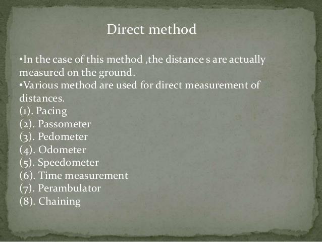
8 Methods There are 3 methods of making linear measurements. 1- Direct Method. 2- Optical Method. 3- E.D.M Method. 8
9 9
10 10
11 11
12 12
13 13
14 14
15 15

16 16
17 17
18 18
19 19
20 20
21 21
22 22
23 23
24 24
25 25
26 26
27 27
28 28
29 29
30 30
31 Taping Corrections Incorrect length Slope Temperature Sag Stretch 31
32 32
33 Slope 33 Trigonometry Horizontal: h = s*cos( ) Calculation s v h s v C h s h s h s v h s C 2 ) )( ( s h v
34 Slope Example If s = = 5 h = 300 cos(5) = v = 300 sin(5) = If you had measured v = C S = v 2 /2S = / = 1.14 h = v C S = = s h v 34
35 Temperature C t k( T T s )( L) k / F / C C t ( T T s )( L) 35
36 Temperature Example Tape calibrated to at 68 F Determine Dist AB = at 22 F Calculate true distance C T = (22-68)(368.50) = True Dist AB = =
37 37
38 38
39 Sag and Tension C s C E p Steel w 2 L 3 W P 24P 2 L ( P Ps ) L AE 29,000,000 psi P 0.204W P Ps AE W = 2.8, A = 0.015, P S = 12 Trial and error -> P = 31 lb 39 If P = 18-lb, P S = 12-lb, L = 100, A = in 2, C P = (18 12)100/(0.015*29,000,000) =
40 40
41 Taping Precision 1/2500 1/ Poor - Average 1/10,000 - Good 41
42 42
43 43

44 44
45 45
46 46
47 47
48 48
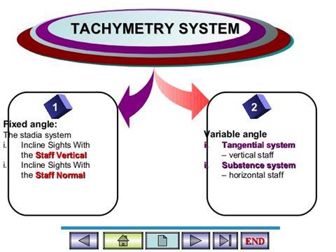
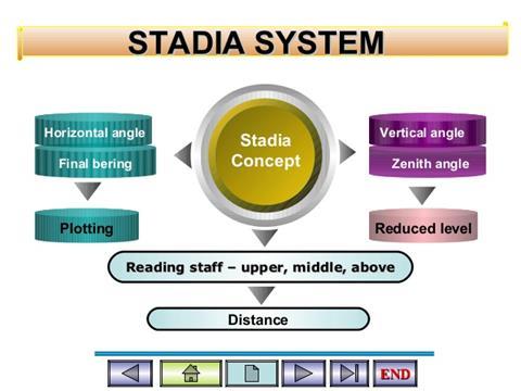
49 Stadia is a tacheometric form of distance measurement that relies on a fixed-angle intercept while tacheometry is the procedure by which horizontal distances and difference in elevations are determined indirectly using subtended intervals and angles observed with a transit or theodolite on a graduated rod or scale. 49
50 50
51 From the previous figure, 51
52 Example: HORIZONTAL SIGHTS 52
53 Solution: 53
54 Inclined Stadia Sights 54
55 55 Enhanced Projection on the Rod
56 56
57 57
58 58
59 Example: INCLINED SIGHTS 59
60 60
61 61

62 62
63 63
64 64
65 65
66 66
67 67

68 Measuring an angle Horizontal angles: use level, transit, or theodolite Vertical angle: use transit or theodolite Either: - graduated circles or - digital readout Both: Principles of Surveying. 2nd ed. C. A. Herubin,
69 Angles: readability Horizontal & vertical circles typically graduated to 1 o for construction grade instruments, 5 or better for survey instruments Vernier improves resolution by 10x or better Principles of Surveying. 2nd ed. C. A. Herubin, 1978 Digital readouts to 5 or better 69
70 70
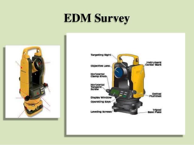
71 71


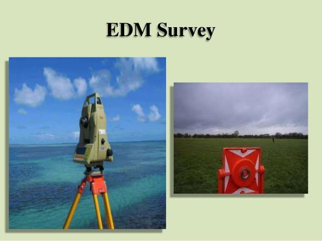
72 Electronic Distance Measurement Optical: uses parallax. Inexpensive but error 1% Ultrasonic: mid-priced. Accuracy ~ 0.1% Laser: moderate to very expensive. Accuracy 1 ppt or better 72
73 Measuring elevations Known as leveling Uses a level (optical or laser) & a rod All measurements are relative (to a starting elevation) Height of instrument 73 Both: Elements of Surveying. U. S. Army, TM 5-232, 1971

74 Optical vs. laser leveling Optical leveling requires 2 workers Laser leveling can be done alone, but easiest when rod is equipped with autodetector (high/low/on signals) Top: Principles of Surveying. 2nd ed. C. A. Herubin, 1978 Bottom: Topcon web site 74
75 Putting it together Two ways of mapping a region: Traversing used to locate specific features Triangulation used to establish a control network over a region 75 Both: Elements of Surveying. U. S. Army, TM 5-232, 1971
76 Types of traverses Allowable misclosure First order, Class I: - 4 mm in 1 km mm in 1000 km Third order: - 12 mm in 1 km mm in 1000 km Land surveys:??? 76 Both: Elements of Surveying. U. S. Army, TM 5-232, 1971

77 The total station Combines theodolite, EDM, data logger & surveying software Log ~ 8000 points, download data to computer Why doesn t ES have one??? 77 Topcon web site
78 Electronic Distance Measurement (EDM): is an instrument that transmits a carrier signal of electromagnetic energy from its position to a receiver located at another position Quick and precise measurements. Save time and money Automatically display direct readout measurements. Mistakes are reduced EDM instruments are combined with digital theodolites and microprocessors to produce total station instruments. Precise taping is one of the most difficult and painstaking of all surveying tasks. 78
79 Basic Instruments An electronic distance-measuring devise A reflector consists of several prisms mounted on a tripod From EDM To EDM Measuring unit or transmitter Reflector 79
80 Types of EDMs Based on the wavelengths of the electromagnetic energy which they transmit, there are two types of EDMs. 1. Electro-optical instruments: transmit light in short wavelengths of about 0.4 to 1.2 µm. (laser and infrared) This light is visible or just above the visible (laser and infrared). Almost all short-range EDMs for measuring up to a few miles are of the infrared type. Laser type are visible 2. Microwave instruments: Transmit long wavelengths of about 10 to 100 µm. The waves penetrate through fog or rain More affected by humidity than are the light-wave instruments. 80
 Shorter")
81 Wavelength a) Longer wavelength b) Shorter wavelength 81
82 82
83 Principles of electronic distance measurement Distance are observed electronically by determine the number of full and partial waves. Knowing the precise length of the wave, the distance can be determined. 83
84 procedure for measuring 1. The EDM device is set up, centred, and levelled at one end of the line. 2. The prism assembly is placed at the other end of the line 3. The telescope is sighted toward the prism and the power is turned on. 4. The instrument transmits a signal to the reflector. 5. The reflector returns the signal to the receiver, so it its travel path is double the distance. 6. The EDM device determines the number of waves in the double path, multiplied by the wavelength, and divided by 2 to obtain the distance. 84
85 Some fractional part of the wavelength would in general be expected, therefore the distance between the EDM instrument and reflector is expressed as: L n 2 p Where L distance between the EDM and the reflector. λ is the wave length n is the number of full wavelength p the length of the fractional part. 85
86 The fractional length is determine by the EDM instrument from measurement of phase angle of the returned signal. λ / 2 λ 0.375λ 0 o 135 o 90 o 180 o 270 o 360 o 86 One cycle A wave length of electromagnetic energy illustrating phase angle
87 Example: Assume that a wavelength is precisely m. Assume also that the number of full waves is 9 and phase angle of the returned signal is o determine the length of the distance being measured. L n 2 p Length p would be (115.7/360) x =6.428 m L m 2
88 Errors in the EDM measurements 1. Personal errors Not Setting the instrument or reflector exactly over the point. Not measuring the instrument height and weather conditions perfectly. 2. Natural errors Variation in temperature, humidity, and pressure. For electro-optical instruments, correction for humidity can be neglected. Snow, fog, rain, and dust affect the visibility factor for EDMs. 3. Instrumental Errors Very small if the equipment has been carefully adjusted and calibrated. 88
INTRODUCTION TO ENGINEERING SURVEYING (CE 1305)
") INTRODUCTION TO ENGINEERING SURVEYING (CE 1305) Linear Measurements Sr Dr. Tan Liat Choon Email: tanliatchoon@gmail.com Mobile: 016-4975551 1 EDM, TOTAL STATION, PRISM AND POLE 2 ELECTROMAGNETIC DISTANCE
INTRODUCTION TO ENGINEERING SURVEYING (CE 1305) Linear Measurements Sr Dr. Tan Liat Choon Email: tanliatchoon@gmail.com Mobile: 016-4975551 1 EDM, TOTAL STATION, PRISM AND POLE 2 ELECTROMAGNETIC DISTANCE
Islamic University of Gaza Civil Engineering Department Surveying II ECIV 2332
 Islamic University of Gaza Civil Engineering Department Surveying II ECIV 2332 By Belal Almassri Chapter 6 Electronic Distance Measurement EDM - Introduction. - Electro-Optical Instrument. - Microwave
Measurement of Horizontal Distances. the distance between two points means the horizontal distance
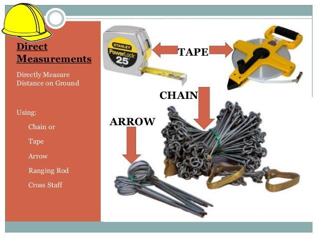
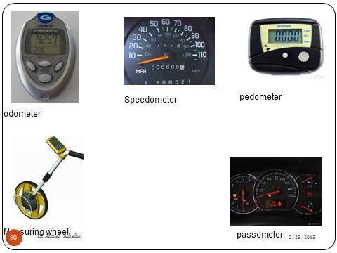
 Measurement of Horizontal Distances the distance between two points means the horizontal distance Pacing Mechanical Devices Taping * Tachymetric Photogrammetric * Electronic Distance Measurement (EDM)
GEOMATICS ENGINEERING
 GEOMATICS ENGINEERING CHAPTER 2 Direct and Indirect Distance Measurement Methods Distance Measurement Methods Equipment Classification Usage Fieldwork procedure Booking system Adjustment and plotting Introduction
Measurement of Distance and Elevation Equipment and Procedures
 AMRC 2012 MODULE 2 Measurement of Distance and Elevation Equipment and Procedures CONTENTS Overview... 2-1 Objectives... 2-1 Procedures... 2-1 2.1 Introduction to Methods of Distance Measurement... 2-3
Site Surveying Procedures for Construction and the Built Environment
 Unit 27: Site Surveying Procedures for Construction and the Built Environment Unit code: R/601/1291 QCF level: 4 Credit value: 15 Aim This unit develops an understanding of the principles of site surveying
-I g in y e SURVEYING-I rv u S
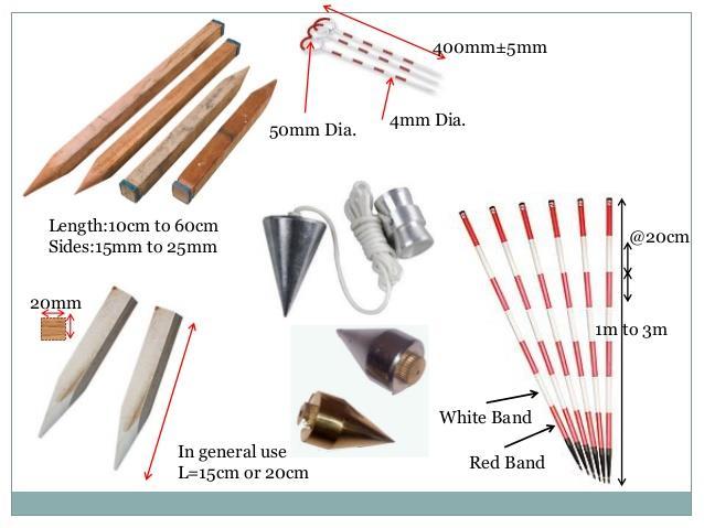
 SURVEYING-I Modern Surveying Chains & other Equipment Measuring Distance The historical method measuring distance is surveying chain. for the One of the first chains used in the U.S. was the Gunter s chain.
Leveling. 3.1 Definitions
 Leveling 3.1 Definitions Leveling is the procedure used to determine differences in elevation between points that are remote from each other. Elevation is a vertical distance above or below a reference
CHENDU COLLEGE OF ENGINEERING & TECHNOLOGY DEPARTMENT OF CIVIL ENGINEERING SUB CODE & SUB NAME : CE6404 SURVEYING II
 CHENDU COLLEGE OF ENGINEERING & TECHNOLOGY DEPARTMENT OF CIVIL ENGINEERING SUB CODE & SUB NAME : CE6404 SURVEYING II UNIT I CONTROL SURVEYING PART A (2 MARKS) 1. What is the main principle involved in
COPYRIGHTED MATERIAL INTRODUCTION CHAPTER 1
 CHAPTER 1 INTRODUCTION 1.1 INTRODUCTION We currently live in what is often termed the information age. Aided by new and emerging technologies, data are being collected at unprecedented rates in all walks
SURVEYING II-2MARKS UNIT-I. 2-Marks
 SURVEYING II-2MARKS UNIT-I 2-Marks 1. Define Tacheometry: Tacheometry is a branch of angular surveying in which the horizontal and vertical distances (or) points are obtained by optional means as opposed
 VALLIAMMAI ENGINEERING COLLEGE Department of Civil Engineering CE6304 SURVEYING I Questions Bank UNIT-I FUNDAMENTALS AND CHAIN SURVEYING Part A 1) Define surveying. 2) What are the types of surveying?
Part 5: Total stations
 Provläsningsexemplar / Preview INTERNATIONAL STANDARD ISO 17123-5 Third edition 2018-02 Optics and optical instruments Field procedures for testing geodetic and surveying instruments Part 5: Total stations
Surveying Prof. Bharat Lohani Department of Civil Engineering Indian Institute of Technology, Kanpur. Module - 3 Lecture - 4 Linear Measurements
 Surveying Prof. Bharat Lohani Department of Civil Engineering Indian Institute of Technology, Kanpur Module - 3 Lecture - 4 Linear Measurements Welcome again to this another video lecture on basic surveying.
UNIT 1- CONTROL SURVEYING PART A
 QUESTION BANK (As per Anna University 2013 Regulation) UNIT 1- CONTROL SURVEYING Horizontal and vertical control Methods specifications triangulation- baseline instruments and accessories corrections satellite
Total station LEICA TPS
 Total station LEICA TPS405 200 The perfect solution for all sites Rugged, adaptable total station with accurate angle measurements, dual-axis compensator, powerful EDM, data output in any format, and application
COPYRIGHTED MATERIAL INTRODUCTION CHAPTER 1
 CHAPTER 1 INTRODUCTION 1.1 INTRODUCTION We currently live in what is often termed the information age. Aided by new and emerging technologies, data are being collected at unprecedented rates in all walks
CE6404 SURVEYING II. 3. Arbitrary Bench Mark: When the RL of some fixed Points are assumed, they are termed a arbitrary Bench mark
 CE6404 SURVEYING II UNIT-I Control Surveying Part - A 1. Permanent Bench mark: These are established by different government departments like PWD, Railways, Irrigation etc., The RL of these points are
Surveying Prof. Bharat Lohani Indian Institute of Technology, Kanpur. Module 5 Lecture 1
 Surveying Prof. Bharat Lohani Indian Institute of Technology, Kanpur (Refer Slide Time: 00:20) Module 5 Lecture 1 Welcome to this another lecture on basic surveying. Today we are going to start a new module.
Fig. 8.1 illustrates the three measurements. air medium A. ray 1. air medium A. ray 2. air medium A. ray 3. Fig For Examiner s Use
 9 9 9 14 8 In an optics lesson, a Physics student traces the paths of three s of light near the boundary between medium A and. The student uses a protractor to measure the various angles. Fig. 8.1 illustrates
PRIMARY CONTROL SURVEYS
 STATE CONTROL SURVEY SPECIFICATIONS FOR PRIMARY CONTROL SURVEYS Now Obsolete Caution: This document has been prepared by scanning the original Specifications for Primary Control Surveys - 1984 and using
Only for Reference Page 1 of 11
 Only for Reference www.civilpddc2013.weebly.com Page 1 of 11 Seat No.: Enrolment No. PDDC - SEMESTER II EXAMINATION WINTER 2013 Subject Code: X20601 Date: 20-12-2013 Subject Name: Advance Surveying Time:
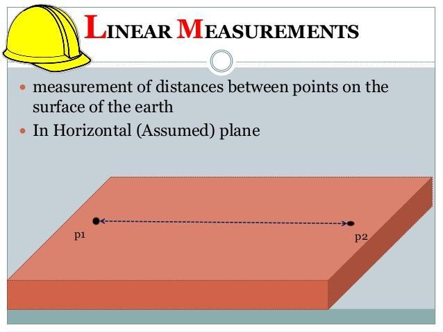
UNIT-4 "LINEAR MEASURMENT" Grounds point Horizontal distance measure Process linear
 UNIT-4 "LINEAR MEASURMENT" Grounds point Horizontal distance measure Process linear measurment method. Direct Mearsurment (chain tape). Measurment by optical measurment(techeometer survey, Triangulation
Astronomical Tools. Optics Telescope Design Optical Telescopes Radio Telescopes Infrared Telescopes X Ray Telescopes Gamma Ray Telescopes
 Astronomical Tools Optics Telescope Design Optical Telescopes Radio Telescopes Infrared Telescopes X Ray Telescopes Gamma Ray Telescopes Laws of Refraction and Reflection Law of Refraction n 1 sin θ 1
DOWNLOAD PDF PLANE AND GEODETIC SURVEYING FOR ENGINEERS
 Chapter 1 : Difference Between Plane Surveying and Geodetic Surveying Geodetic surveying. Effect of the curvature of the earth surface is ignored. The earth surface is assumed to be plane, i.e. two dimensional.
Surveying Instruments. B Series B20 B30 B40. Automatic Levels
 Surveying Instruments B Series B20 B30 B40 Automatic Levels World-Proven Precision and Durability B20 Automatic Level B30 Automatic Level B40 Automatic Level 28x 1.5mm Accuracy 32x 0.7mm Accuracy 24x 2.0mm
Angelo Filomeno
 Angelo Filomeno www.angelofilomeno.com In these lectures we will cover : The role of linear measurement Equipment Procedures and rules Errors Applications of linear measurement 27.9 metres Simply the measurement
Practice Questions - Revision
 Practice Questions - Revision Question 1: (a) The data from a survey, are shown below. Use either the Rise and Fall method or the Height of Plane of Collimation (HPC) method to reduce the data. Use arithmetic
Digital Land Surveying And Mapping(DLS&M) Dr. Jayanta Kumar Ghosh Department of Civil Engineering Indian Institute of Technology, Roorkee
 Dr. Jayanta Kumar Ghosh Department of Civil Engineering Indian Institute of Technology, Roorkee") Digital Land Surveying And Mapping(DLS&M) Dr. Jayanta Kumar Ghosh Department of Civil Engineering Indian Institute of Technology, Roorkee Lecture - 17 Total Station Introduction Welcome students, this
Digital Land Surveying And Mapping(DLS&M) Dr. Jayanta Kumar Ghosh Department of Civil Engineering Indian Institute of Technology, Roorkee Lecture - 17 Total Station Introduction Welcome students, this
NCEES FS Practice Exam
 NCEES FS Practice Exam Terrametra Resources Lynn Patten 1. One corner of a 60-ft. 120-ft. lot, otherwise rectangular, is a curve with a radius of 20 ft. and a central angle of 90. The area (ft. 2 ) of
UNCERTAINTY IN TACHEOMETRIC MEASUREMENT OF CONVERGENCES IN TUNNELS
 3rd IAG / 1th FIG Symposium, Baden, May -4, 006 UNCERTAINTY IN TACHEOMETRIC MEASUREMENT OF CONVERGENCES IN TUNNELS Maria João Henriques João Casaca National Laboratory for Civil Engineering Lisbon, Portugal
Aim: to give a description of the sources and significance of errors and an understanding of accuracy and precision of measurements.
 ACET108 SURVEYING I Sources of errors Precision and Accuracy Trigonometry A. Sources of Errors Aim: to give a description of the sources and significance of errors and an understanding of accuracy and
Introduction to Land Measurement (Field Surveying and Navigation)
") Introduction to Land Measurement (Field Surveying and Navigation) ESRM 304 Peter Schiess / Eric Turnblom 1 of 37 Overview Overview of surveying Survey mathematics Collecting and recording data Correcting
Introduction to Land Measurement (Field Surveying and Navigation) ESRM 304 Peter Schiess / Eric Turnblom 1 of 37 Overview Overview of surveying Survey mathematics Collecting and recording data Correcting
Cleveland State University
 CVE 212 - Surveying Lab #1 MEASURING ANGLES & DISTANCES WITH A TOTAL STATION EQUIPMENT EDMI and Tripod Single prism mounted on a prism pole Field book Pencil 2 Walkie Talkies INTRODUCTION Recent developments
Planetary Science: Investigations 9-10 I-Check Quiz STUDY GUIDE Name HR Date
 1. How are different types of radiation arranged along the electromagnetic spectrum? A. By how fast they travel incorrect answer B. By their sources incorrect answer C. By the amount of energy they carry
Package No.-36(Surveyor) Annexure -III
 Annexure -III") Package No.-36(Surveyor) Annexure -III Reference- Clause-8 of DTCN S.L.No Item Quantity 1 Abney level.tube is 5 1/8 in. long, Radius arc of 1 1/8 in. graduated in degrees in both directions,vernier reading
Package No.-36(Surveyor) Annexure -III Reference- Clause-8 of DTCN S.L.No Item Quantity 1 Abney level.tube is 5 1/8 in. long, Radius arc of 1 1/8 in. graduated in degrees in both directions,vernier reading
Unit 5 Lesson 1 Images from Space. Copyright Houghton Mifflin Harcourt Publishing Company
 Florida Benchmarks SC.8.N.4.2 Explain how political, social, and economic concerns can affect science, and vice versa. SC.8.E.5.10 Assess how technology is essential to science for such purposes as access
Surveying Prof. Bharat Lohani Indian Institute of Technology, Kanpur. Module - 5 Lecture - 3 Theodolites and Total Stations
 Surveying Prof. Bharat Lohani Indian Institute of Technology, Kanpur Module - 5 Lecture - 3 Theodolites and Total Stations (Refer Slide Time: 00:31) Welcome to another lecture on basic surveying. This
Cleveland State University
 CVE 212 - Surveying Lab #6 MEASURING ISTANCES USING STAIA METHOS EQUIPMENT Transit or theodolite with stadia hairs and tripod Philadelphia leveling rod Field book No. 3 drafting pencil INTROUCTION When
22X Builder s Level Model No Instruction Manual
 2594H 7/29/09 10:12 AM Page 1 22X Builder s Level Model No. 40-6900 Instruction Manual Congratulations on your choice of this 22X Builder s Level. We suggest you read this instruction manual thoroughly
EHST 2361 Surveying Locations & Elevations of Ground Water Monitoring Wells
 EHST 2361 Surveying Locations & Elevations of Ground Water Monitoring Wells Purpose: This lab will acquaint you with a method for plotting ground water monitoring well (GWMW) relative locations and determining
Provläsningsexemplar / Preview INTERNATIONAL STANDARD ISO Second edition
 INTERNATIONAL STANDARD ISO 17123-4 Second edition 2012-06-01 Optics and optical instruments Field procedures for testing geodetic and surveying instruments Part 4: Electro-optical distance meters (EDM
Summative Practical: Motion down an Incline Plane
 Summative Practical: Motion down an Incline Plane In the next lesson, your task will be to perform an experiment to investigate the motion of a ball rolling down an incline plane. For an incline of 30,
71- Laxmi Nagar (South), Niwaru Road, Jhotwara, Jaipur ,India. Phone: Mob. : /
, Niwaru Road, Jhotwara, Jaipur ,India. Phone: Mob. : /") www.aarekh.com 71- Laxmi Nagar (South), Niwaru Road, Jhotwara, Jaipur 302 012,India. Phone: 0141-2348647 Mob. : +91-9799435640 / 9166936207 1. An invar tape made of an alloy of: A. Copper and steel. B.
www.aarekh.com 71- Laxmi Nagar (South), Niwaru Road, Jhotwara, Jaipur 302 012,India. Phone: 0141-2348647 Mob. : +91-9799435640 / 9166936207 1. An invar tape made of an alloy of: A. Copper and steel. B.
DETERMINATION OF AREA OF POLYGON BY CHAIN AND CROSS STAFF SURVEY 1. AIM:
 Expt. No: 2 Date: DETERMINATION OF AREA OF POLYGON BY CHAIN AND CROSS STAFF SURVEY 1. AIM: To determine the area of a given field with define boundary by conducting cross staff survey. 2. INSTRUMENTS REQUIRED:
Alignment-Aspects for the HERA-Experiments ZEUS and H1
 383 Alignment-Aspects for the HERA-Experiments ZEUS and H1 E. Weiß, T. Dobers, H.-P. Lohmann, M. Krendler DESY Hamburg, October 1990 1 Introduction At the HERA accelerator two detectors, H1 and ZEUS. are
MAHATMA GANDHI MISSION S JAWAHARLAL NEHRU ENGINEERING COLLEGE, AURANGABAD. (M.S.)
") MAHATMA GANDHI MISSION S JAWAHARLAL NEHRU ENGINEERING COLLEGE, AURANGABAD. (M.S.) DEPARTMENT OF CIVIL ENGINEERING SURVEYING - II LAB MANUAL Prof.R.V.Wanjule Approved By Lab Incharge Dr. S. B. Shinde H.O.D.
MAHATMA GANDHI MISSION S JAWAHARLAL NEHRU ENGINEERING COLLEGE, AURANGABAD. (M.S.) DEPARTMENT OF CIVIL ENGINEERING SURVEYING - II LAB MANUAL Prof.R.V.Wanjule Approved By Lab Incharge Dr. S. B. Shinde H.O.D.
Engineering Surveying
 6 Engineering Surveying T J M Kennie BSc, MAppSci (Glasgow), ARICS, MInstCES Lecturer in Engineering Surveying, University of Surrey Contents 6.1 Introduction 6/3 6.1.1 Branches of surveying 6/3 6.1.2
Infrared Temperature Calibration 101 Using the right tool means better work and more productivity
 Infrared Temperature Calibration 101 Using the right tool means better work and more productivity Application Note Infrared thermometers let you measure a target s surface temperature from a distance without
CE6304 SURVEYING I TWO MARKS UNIT-I FUNDAMENTALS AND CHAIN SURVEYING
 CE6304 SURVEYING I TWO MARKS UNIT-I FUNDAMENTALS AND CHAIN SURVEYING 1. Define surveying and list out its various classification. Classify surveying based on instrument used. Based on the instruments used
22X Builder s Transit Level Model No Instruction Manual
 2595H 7/29/09 10:15 AM Page 1 22X Builder s Transit Level Model No. 40-6910 Instruction Manual Congratulations on your choice of this 22X Builder s Transit Level. We suggest you read this instruction manual
SURVEYING II (FOR IV SEMESTER)
") SURVEYING II (FOR IV SEMESTER) UNIT I UNIT II UNIT III UNIT IV UNIT V = TACHEOMETRIC SURVEYING = CONTROL SURVEYING = SURVEY ADJUSTMENTS = ASTRONOMICAL SURVEYING = HYDROGRAPHIC AND ADVANCE SURVEYING PREPARED
SURVEYING II (FOR IV SEMESTER) UNIT I UNIT II UNIT III UNIT IV UNIT V = TACHEOMETRIC SURVEYING = CONTROL SURVEYING = SURVEY ADJUSTMENTS = ASTRONOMICAL SURVEYING = HYDROGRAPHIC AND ADVANCE SURVEYING PREPARED
Surveying Prof. Bharat Lohani Department of Civil Engineering Indian Institute of Technology, Kanpur. Module - 11 Lecture No. # 01 Project surveys
 Surveying Prof. Bharat Lohani Department of Civil Engineering Indian Institute of Technology, Kanpur Module - 11 Lecture No. # 01 Project surveys (Refer Slide Time: 00:24) Welcome to this video lecture,
Engineering Metrology
 Albaha University Faculty of Engineering Mechanical Engineering Department Engineering Metrology Lecture 04: Angular Measurements Ossama Abouelatta o_abouelatta@yahoo.com Mechanical Engineering Department
FOCUS 30/FOCUS 35 Field Calibration with Survey Pro Field Software
 GeoInstruments Application Note June 25th, 2015 FOCUS 30/FOCUS 35 Field Calibration with Survey Pro Field Software Summary: This support note outlines the procedure which should be followed to calibrate
UNIT E: SPACE EXPLORATION
 UNIT E: SPACE EXPLORATION S C I E N C E 9 1 Science 9 Unit E Section 3.0 OPTICAL TELESCOPES, RADIO TELESCOPES, AND OTHER TECHNOLOGIES ADVANCE OUR UNDERSTANDING OF SPACE SECTI ON 3.0 Science 9 Unit E Section
Carlson CR Robotic/Reflectorless Total Station
 0 West Second Street Suite 00 Maysville, KY 4056 www.carlsonsw.com Phone: 606-564-508 Fax: 606-564-64 Type starts around here Carlson CR Robotic/Reflectorless Total Station Calibration Overview Congratulations
Surveying Prof. Bharat Lohani Department of Civil Engineering Indian Institute of Technology, Kanpur
 Surveying Prof. Bharat Lohani Department of Civil Engineering Indian Institute of Technology, Kanpur Module - 12 Lecture - 1 Global Positioning System (Refer Slide Time: 00:20) Welcome to this video lecture
Introduction to Measurements. Introduction to Measurements. Introduction to Measurements. Introduction to Measurements. Introduction to Measurements
 CIVL 1112 Surveying - Precision and 1/8 Typically, we are accustomed to counting but not measuring. Engineers are concerned with distances, elevations, volumes, direction, and weights. Fundamental principle
PHYS 160 Astronomy Test #2 Fall 2017 Version A
 PHYS 160 Astronomy Test #2 Fall 2017 Version A I. True/False (1 point each) Circle the T if the statement is true, or F if the statement is false on your answer sheet. 1. A blackbody emits all of its radiation
What is the maximum distance I can have the remote sensors from the display?
 What is the maximum distance I can have the remote sensors from the display? The maximum open-air distance is 100 meters in a straight line although you should take into account the environment, distance
Planetary Science: Investigations 9-10 I-Check Quiz STUDY GUIDE- ANSWER KEY Name HR Date
 1. How are different types of radiation arranged along the electromagnetic spectrum? A. By how fast they travel incorrect answer B. By their sources incorrect answer C. By the amount of energy they carry
Methods and Tools of Physics
 Methods and Tools of Physics Order of Magnitude Estimation: Essential idea: Scientists aim towards designing experiments that can give a true value from their measurements, but due to the limited precision
Auto collimator. Introduction. Objectives: Apparatus: Theory:
 Auto collimator Introduction An autocollimator is an optical instrument that is used to measure small angles with very high sensitivity. As such, the autocollimator has a wide variety of applications including
Physics/Science Unit P1: Universal Physics
 Write your name here Surname Other names Edexcel GCSE Centre Number Physics/Science Unit P1: Universal Physics Wednesday 9 November 2011 Morning Time: 1 hour You must have: Calculator, ruler Candidate
Grade 8 Science Unit 2: Optics Chapters 4, 5 and 6
 Grade 8 Science Unit 2: Optics Chapters 4, 5 and 6 At the end of this unit, students will be expected to 1. Provide examples of ideas and theories of light used in the past to explain observed properties.
Experimental Uncertainty (Error) and Data Analysis
 and Data Analysis") Experimental Uncertainty (Error) and Data Analysis Advance Study Assignment Please contact Dr. Reuven at yreuven@mhrd.org if you have any questions Read the Theory part of the experiment (pages 2-14) and
Experimental Uncertainty (Error) and Data Analysis Advance Study Assignment Please contact Dr. Reuven at yreuven@mhrd.org if you have any questions Read the Theory part of the experiment (pages 2-14) and
*1731* e) Define local attraction. State two causes of local attraction. f) State two principles of plane table survey. g) Define horizontal l
 Define local attraction. State two causes of local attraction. f) State two principles of plane table survey. g) Define horizontal l") *1731* 1731 21415 3 Hours/1 Marks S e a t o. Instructions : (1) All questions are compulsory. (2) Answer each next main question on a new page. (3) Illustrate your answers with neat sketches wherever necessary.
*1731* 1731 21415 3 Hours/1 Marks S e a t o. Instructions : (1) All questions are compulsory. (2) Answer each next main question on a new page. (3) Illustrate your answers with neat sketches wherever necessary.
Remote Sensing in Meteorology: Satellites and Radar. AT 351 Lab 10 April 2, Remote Sensing
 Remote Sensing in Meteorology: Satellites and Radar AT 351 Lab 10 April 2, 2008 Remote Sensing Remote sensing is gathering information about something without being in physical contact with it typically
It is the art of determining the relative positions of natural and artificial features on the earth s surface, vertically and horizontally.
 SVG 105 Lectures Notes March 2011 BASIC INTRODUCTION TO SURVEYING DEFINITION OF SURVEYING It is the art of determining the relative positions of natural and artificial features on the earth s surface,
5. What is not typically considered to be a cause of natural error when using EDM devices?
 Student ID: 22093585 Exam: 498868RR - Introduction to Surveying and Measurement When you have completed your exam and reviewed your answers, click Submit Exam. Answers will not be recorded until you hit
Telescopes. Lecture 7 2/7/2018
 Telescopes Lecture 7 2/7/2018 Tools to measure electromagnetic radiation Three essentials for making a measurement: A device to collect the radiation A method of sorting the radiation A device to detect
Basic Field Instruments Field Orientation, Basic Navigation ESRM 304
 Basic Field Instruments Field Orientation, Basic Navigation ESRM 304 Three Basic Navigation Measurements Direction Distance Elevation (or change in it) 2 Compass for Direction Looking from point to point,
The latitude and longitude of the Shrine can be taken as: φ = 37º 49' 55" and λ = 144º 58' 20"
 SHRINE ASSIGNMENT One of the best known features of the Shrine of Remembrance in Melbourne is the beam of sunlight that falls on the Stone of Remembrance on Armistice day at the 11th hour of the 11th day
The SuperBall Lab. Objective. Instructions
 1 The SuperBall Lab Objective This goal of this tutorial lab is to introduce data analysis techniques by examining energy loss in super ball collisions. Instructions This laboratory does not have to be
The FLIP Experiment: Testing the Relationship of Length of Upwelling Tubes to Maximize Upwelling Velocity
 The FLIP Experiment: Testing the Relationship of Length of Upwelling Tubes to Maximize Upwelling Velocity Anthony T. Jones, Ph.D. Oceanographer oceanus consulting Introduction The Hydrocratic Generator
WeatherHawk Weather Station Protocol
 WeatherHawk Weather Station Protocol Purpose To log atmosphere data using a WeatherHawk TM weather station Overview A weather station is setup to measure and record atmospheric measurements at 15 minute
GE 100: General Surveying I
 : General I INTRODUCTION TO SURVEYING Lecture No. Caraga State University College of Engineering and Information Technology SURVEYING It is the art and science of determining angular and linear measurements
Last Time. GY 301: Geomorphology. Today s Agenda. Vertical Exaggeration UNIVERSITY OF SOUTH ALABAMA. Another Simple day; Topographic Profiles
 UNIVERSITY OF SOUTH ALABAMA GY 301: Geomorphology Lecture 5: Alidade & Plane Table Methods Last Time Another Simple day; Topographic profiles Drawing topographic profiles Vertical exaggeration Topographic
Applied Geomorphology. Pocket Transit Survey Methods
 Applied Geomorphology Pocket Transit Survey Methods The Pocket Transit (Brunton) Used to measure compass directions Allows for magnetic declination correction Can measure vertical angles with clinometer.
Astronomy. Optics and Telescopes
 Astronomy A. Dayle Hancock adhancock@wm.edu Small 239 Office hours: MTWR 10-11am Optics and Telescopes - Refraction, lenses and refracting telescopes - Mirrors and reflecting telescopes - Diffraction limit,
Figure 1 shows white light passing through a triangular glass prism. The white light splits up into different colours. Two of the colours are shown.
 Name Q9.Visible white light consists of several different colours. Figure 1 shows white light passing through a triangular glass prism. The white light splits up into different colours. Two of the colours
Angular Momentum. Brown University Physics 0030 Physics Department Lab 4
 Angular Momentum Introduction In this experiment, we use a specially designed air table on which we cause the collisions of a ball and a disk, and so observe the consequence of angular momentum conservation.
Determining the Concentration of a Solution: Beer s Law
 Determining the Concentration of a Solution: Beer s Law LabQuest 11 The primary objective of this experiment is to determine the concentration of an unknown nickel (II) sulfate solution. You will be using
ELECTROMAGNETIC SPECTRUM All waves travel the SAME speed (the speed of light) 300,000 km/sec (186,000 miles/sec) in a vacuum
 300,000 km/sec (186,000 miles/sec) in a vacuum") ELECTROMAGNETIC SPECTRUM All waves travel the SAME speed (the speed of light) 300,000 km/sec (186,000 miles/sec) in a vacuum 10 4 Hz 10 6 Hz 10 8 Hz 10 12 Hz 10 14 Hz 10 16 Hz 10 18 Hz 1 million 1 trillion
ELECTROMAGNETIC SPECTRUM All waves travel the SAME speed (the speed of light) 300,000 km/sec (186,000 miles/sec) in a vacuum 10 4 Hz 10 6 Hz 10 8 Hz 10 12 Hz 10 14 Hz 10 16 Hz 10 18 Hz 1 million 1 trillion
~.LIETZ ~. LI ETZ INSTRUCTION MANUAL DOUBLE CENTER THEODOLITE TM-20C THE LIETZ COMPANY E. Del Arno Blvd. Carson, Ca (213)
") ~.LIETZ DOUBLE CENTER THEODOLITE TM-20C INSTRUCTION MANUAL f~, ~. LI ETZ THE LIETZ COMPANY 1645 E. Del Arno Blvd. Carson, Ca. 90746. (213)537-0410 n INSTRUMENT NOMENCLATURE cr, il (~ iíl i) Ii: in CD CD
~.LIETZ DOUBLE CENTER THEODOLITE TM-20C INSTRUCTION MANUAL f~, ~. LI ETZ THE LIETZ COMPANY 1645 E. Del Arno Blvd. Carson, Ca. 90746. (213)537-0410 n INSTRUMENT NOMENCLATURE cr, il (~ iíl i) Ii: in CD CD
CE 311. Elementary & Higher Surveying
 CE 311 Elementary & Higher Surveying Surveying Concept What do surveyors do? What do surveyors measure? What distances do surveyors measure? What angles do surveyors measure? What positions do surveyors
The Accuracy of Electronic Distance Meters over Short Distances
 263 The Accuracy of Electronic Distance Meters over Short Distances Braun, J., Štroner, M. and Urban, R. Czech Technical University in Prague, Faculty of Civil Engineering, Department of Special Geodesy,
II. COMPASS SURVEYING AND PLANE TABLE SURVEYING :
 1 II. COMPASS SURVEYING AND PLANE TABLE SURVEYING : Prismatic compass surveyor s compass bearing system of conversions Local attraction magnetic declination Dip Traversing Plotting Adjustment of errors
WATTS MICROPTIC ALIDADE OPERATING INSTRUCTIONS 20-7
 WATTS MICROPTIC ALIDADE 20-7 OPERATING INSTRUCTIONS WATTS Operating Instructions for the WATTS MICROPTIC ALIDADE SA100 SA101 RANK PRECISION INDUSTRIES METROLOGY DIVISION Survey Equipment Sales Langston
SNC2D PHYSICS 4/27/2013. LIGHT & GEOMETRIC OPTICS L What Is Light? (P ) What Is Light? What Is Light?
 What Is Light? What Is Light?") SNC2D PHYSICS LIGHT & GEOMETRIC OPTICS L What Is Light? (P.380-391) What Is Light? For centuries, scientists have tried to understand the nature of light and its properties. Some of these properties are
SNC2D PHYSICS LIGHT & GEOMETRIC OPTICS L What Is Light? (P.380-391) What Is Light? For centuries, scientists have tried to understand the nature of light and its properties. Some of these properties are
CIV : THEODOLITE ADJUSTMENT
 Unit CIV2202: Surveying 10.1 CIV2202.10: THEODOLITE ADJUSTMENT Table of Contents PREVIEW...2 Introduction...2 Objectives...2 Readings...2 REGULAR CHECKS...2 Tripod...2 Footscrews...2 Tribrach head...3
Graphing. C= d (1) Under constant acceleration, the relationship between the distance s an object moves and the time t it takes is given by
 Under constant acceleration, the relationship between the distance s an object moves and the time t it takes is given by") Graphing Name Section Physics itself is all about mathematical relationships between variables. In class, you will study some of the more important relationships that have been found to exist. In the lab,
Graphing Name Section Physics itself is all about mathematical relationships between variables. In class, you will study some of the more important relationships that have been found to exist. In the lab,
UNIT-4 THEODOLITE SURVEYING
 UNIT-4 THEODOLITE SURVEYING The Theodolite The measurement of horizontal and vertical angles and it is the most precise instrument designed for points on line, prolonging survey lines, establishing grades,
Mechanical Behavior of a Spring R. Hooke, DePotentia Restitutiva (1678)
") Mechanical Behavior of a Spring R. Hooke, DePotentia Restitutiva (1678) We have measured the strength k of a mechanical spring using both static and dynamic methods. In the static method, we explored Hooke
Mechanical Behavior of a Spring R. Hooke, DePotentia Restitutiva (1678) We have measured the strength k of a mechanical spring using both static and dynamic methods. In the static method, we explored Hooke
CLASSICS. Handbook of Solar Radiation Data for India
 Solar radiation data is necessary for calculating cooling load for buildings, prediction of local air temperature and for the estimating power that can be generated from photovoltaic cells. Solar radiation
Mandatory Assignment 2013 INF-GEO4310
 Mandatory Assignment 2013 INF-GEO4310 Deadline for submission: 12-Nov-2013 e-mail the answers in one pdf file to vikashp@ifi.uio.no Part I: Multiple choice questions Multiple choice geometrical optics
Objective questions for Practical Examination (CBCS scheme) Introduction to Surveying CE-112
 Introduction to Surveying CE-112") Objective questions for Practical Examination (CBCS scheme) Introduction to Surveying CE-112 1. The curvature of the earth s surface, is taken into account only if the extent of survey is more than i)
Objective questions for Practical Examination (CBCS scheme) Introduction to Surveying CE-112 1. The curvature of the earth s surface, is taken into account only if the extent of survey is more than i)
Chapter 5 Telescopes
 Chapter 5 Telescopes Units of Chapter 5 Telescope Design Images and Detectors The Hubble Space Telescope Telescope Size High-Resolution Astronomy Radio Astronomy Interferometry Space-Based Astronomy Full-Spectrum
ADL110B ADL120 ADL130 ADL140 How to use radar and strike images. Version
 ADL110B ADL120 ADL130 ADL140 How to use radar and strike images Version 1.00 22.08.2016 How to use radar and strike images 1 / 12 Revision 1.00-22.08.2016 WARNING: Like any information of the ADL in flight