SURVEYING 1 CE 215 CHAPTER -3- LEVEL AND LEVELING
|
|
|
- Bryan Bishop
- 5 years ago
- Views:
Transcription

1 Civil Engineering Department SURVEYING 1 CE 215 CHAPTER -3- LEVEL AND LEVELING 1 CHAPTER -3- LEVEL AND LEVELING 2 1
2 CONTENTS 1. Level instrument 2. Bubble 3. Tripod 4. Leveling staff 5. Definitions 6. Reading a staff 7. Finding the target 8. Basic rules for leveling 9. Field notes 10. Procedure of leveling 11. Leveling errors 12. Types of leveling 3 1. Level instrument 2

3 1. Base Plate 2. Horizontal Circle 3. Eyepiece 4. Circular Bubble 5. Sighting Pointer 6. Objective Lens 7. Focusing Knob 8. Fine Motion Drive 9. Footscrew 10. Bubble Mirror Level instrument 5 BASIC COMPONENTS OF LEVEL: 1. Telescope to provide a line of sight 2. Level Tube to make line of sight horizontal 3. Levelling head to bring the bubble of tube level at the centre of its run. 4. Tripod to support the above three parts of the level. 6 3

4 7 Leveling of the instrument is done to make the vertical axis of the instrument truly vertical. It is achieved by carrying out the following steps: Step 1: The level tube is brought parallel to any two of the foot screws, by rotating the upper part of the instrument. Step 2: The bubble is brought to the centre of the level tube by rotating both the foot screws either inward or outward. (The bubble moves in the same direction as the left thumb.) Step 3: The level tube is then brought over the third foot screw again by rotating the upper part of the instrument. Step 4: The bubble is then again brought to the centre of the level tube by rotating the third foot screw either inward or outward. 4


5 Level Instrument 2. Bubble When bubble is centred the instrument s standing axis is approximately vertical. The compensators in the instrument take over and adjust the optical Line of Collimation so that it is horizontal (hopefully). 10 5


6 Keep the pole upright Any tilt will disturb your readings Tripod From easy to sit to ops, this is high 12 6


7 Tripod stand :- is a portable three-legged frame, used as a platform for supporting the weight and maintaining the stability of some other object. TRIPOD STAND Leveling staff Leveling Staff :-Is a wooden or metal ruler one side runway to meters and centimeters. And is a ruler of solid wood 2, 3, 4, 5 meters in length and usually 4 meters. 14 7
8
9
 :-Is the level (line), which are attributed to it points levels on the surface of the Earth. Which is the average sea level. 2.")


10 19 5. Definitions 1. Datum line (M.S.L.) :-Is the level (line), which are attributed to it points levels on the surface of the Earth. Which is the average sea level. 2. Reduced level (R.L) :- Is the high point from datum line. Or height or depth of a point above or below the assumed datum. 3. Benchmark (B.M.) :-Are fixed points information site and attributed placed in different places until you start racing them when conducting settlement. Or is a fixed reference point of known elevation. It may be of the following types; 4. Level Surface :- A level surface is a surface, all points of which are normal to the pull of gravity. I.e. a line at right angles to the string line on a freely suspended plumb bob. The open sea provides a good example of a level surface. 10
. b.")
11 21 a. GTS Bench mark (Geodetic Triangulation Survey): These Bench marks are established by national agency like Survey of India. They are established with highest precision. Their position and elevation above MSL is given in a special catalogue known as GTS Maps ( 100 km. interval). b. Permanent Bench Mark : They are fixed points of reference establish with reference to GTS Bench mark (10 km. interval). c. Arbitrary Bench mark : These are reference points whose elevations are arbitrarily assumed. In most of Engineering projects, the difference in elevation is more important than their reduced levels with reference to MSL as given in a special catalogue known as GTS Maps ( 100 Km. interval)
12 5. Back sight (B.S.) :- Is the first reading taken after placing the device in any position so that we see the greatest possible number of points required to find the elevation. 6. Change Point (CP) :- The point on which both the foresight and back sight are taken during the operation of levelling is called change point. 7. Fore sight (F.S) :- Is the last reading taken before the transfer device. 8. Intermediate sight (I.S.) :- Is reading taken between the back sight and fore sight reading. 9. Elevation of line of sight (H.I) :- Is the imaginary vertical level determined by the line of sight to the amount of increase or decrease for sea level (Height of Instrument). Measures height differences between points. Leveling rods Line of sight Back sight Fore sight 24 12
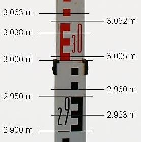
![Benchmarks Read the [m], [dm] &](/docs-images/85/91864944/images/13-0.jpg "[cm] Estimate the [mm] 6.")

13 Benchmarks Read the [m], [dm] & [cm] Estimate the [mm] 6. Reading a Staff Check yourself for frequent used numbers (2/3) or (7/8) 26 13
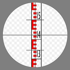
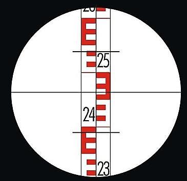
14 7. Finding the Target Most telescopes have a targeting system along the top of the barrel (similar to a rifle target finder). The telescope should be aimed at the staff using this targeting system prior to trying to find the staff through the eyepiece. Staff Target finder (Look at this and beyond towards staff) Eye-piece Staff Target finder (In line with staff) Eye-piece MOVE TELESCOPE UNTIL TRIANGLE APPEARS OVER STAFF Telescope Telescope Basic Rules for Leveling Always start and finish a leveling run on a Benchmark (BM or TGBM) and close the loops. Keep fore sight and back sight distances as equal as possible. Keep lines of sight short (normally < 50m). Never read below 0.5m on a staff (refraction). Use stable, well defined change points. Beware of shadowing effects and crossing waters
15 9. Field Notes S2 New Benchmark NB1 New Benchmark NB2 Back Inter Fore Point TH NB1 NB2 NB1 TH Tidal Hut TH S Procedure of leveling 1. The instrument must be check before use! 2. The instrument and level must be stable settled-up 3. The bubble tube must be leveled before the reading Beware of sun exposure (will wander) Ensure the instruments pendulum is in-limit 4. The instrument must be set up in the middle between two staffs Prevents curvature effects If impossible, use the same distances, but opposite for the next readings 5. You must not use the parallax screw between the backsight and foresight readings 30 15
16 6. Readings must be taken cm above the ground Surface refractions Beware also of temperature gradients (inside/outside buildings). 7. Staff should be set up vertically 8. A change plate should be used 9. Leveling must be done in two opposite directions but the same line (beware of gravity gradients) 10. Staff should be calibrated, especially if INVAR 11. Be careful when crossing rivers (large water surfaces) Use same-time (mutual) observations Repeat it during different times of the day Leveling Errors There are a large number of potential sources of errors in leveling. Many of these are only significant for precise leveling over long distances. For the short segments of leveling that will occur in connecting a TGBM to nearby benchmarks there are only four worth mentioning: a. Collimation Error b. Error due to Earth Curvature c. Error due to Parallax Error d. Error due to Refraction 32 16
17 a. Collimation Error Line of Collimation Imaginary line that passes through leveling instrument at Cross Hairs 33 Collimation Error 34 17
18 b. Parallax Error When using an optical instrument both the image and cross hairs can be focused- if either is imprecisely focused, the cross hairs will appear to move with respect to the object focused, if one moves one's head horizontally in front of the eyepiece. 35 Parallax Error 36 18
19 c. Curvature of the Earth Due to the curvature of the Earth, the line of sight at the instrument will deviate from a horizontal line as one moves away from the level Types of Levelling 1) Simple levelling 2) Differential levelling 3) Fly levelling 4) Profile levelling 5) Cross sectional levelling 6) Reciprocal levelling 38 19

20 1. Simple levelling:- When the difference in the elevation of two nearby points is required then simple levelling is performed Differential levelling:- Performed when the final point is very far from the initial point

21 3. Fly levelling Performed when the work site is very far away from the bench mark. The surveyor starts by taking BS at BM and proceed towards worksite till he finds a suitable place for temporary BM. All works are done with respect to temporary BM. At the end of the day the surveyor comes back to original BM. This is called fly levelling Profile levelling:- Profile levelling, which yields elevations at definite points along a reference line, provides the needed data for designing facilities such as highways, railroads, transmission lines. Reduced levels at various points at regular interval along the line is calculated. After getting the RL of various points the profile is drawn. Normally vertical scale is much larger than horizontal scale for the clear view of the profile


22 5. Reciprocal levelling:- When levelling across river is required then this method is applied to get rid of various errors
SURVEYING 1 CE 215 CHAPTER -3- LEVEL AND LEVELING
 Civil Engineering Department SURVEYING 1 CE 215 CHAPTER -3- LEVEL AND LEVELING 1 CHAPTER -3- LEVEL AND LEVELING 2 1 CONTENTS 1. Level instrument 2. Bubble 3. Tripod 4. Leveling staff 5. Definitions 6.
Leveling. 3.1 Definitions
 Leveling 3.1 Definitions Leveling is the procedure used to determine differences in elevation between points that are remote from each other. Elevation is a vertical distance above or below a reference
Sub. Code:
 (ISO/IEC - 700-005 Certified) Model Answer: Summer 08 Code: 05 Important Instructions to examiners: ) The answers should be examined by key words and not as word-to-word as given in the model answer scheme.
CE 271 Spring Survey Camp
 PART IV LEVELING A. Importance of Leveling The determination of elevations with a surveying instrument, which is known as leveling, is a relatively simple but extraordinarily important process. B. Definitions
Objective questions for Practical Examination (CBCS scheme) Introduction to Surveying CE-112
 Introduction to Surveying CE-112") Objective questions for Practical Examination (CBCS scheme) Introduction to Surveying CE-112 1. The curvature of the earth s surface, is taken into account only if the extent of survey is more than i)
Objective questions for Practical Examination (CBCS scheme) Introduction to Surveying CE-112 1. The curvature of the earth s surface, is taken into account only if the extent of survey is more than i)
Surveying Prof. Bharat Lohani Indian Institute of Technology, Kanpur. Module - 5 Lecture - 3 Theodolites and Total Stations
 Surveying Prof. Bharat Lohani Indian Institute of Technology, Kanpur Module - 5 Lecture - 3 Theodolites and Total Stations (Refer Slide Time: 00:31) Welcome to another lecture on basic surveying. This
Owner's Manual NSL100B BUILDERS LEVEL NSL500B TRANSIT LEVEL
 Owner's Manual NSL100B BUILDERS LEVEL NSL500B TRANSIT LEVEL 1 1. CONTENTS 2. Nomenclature page 3 3. Care and Maintenance page 4 4. Using your Instrument 4.1 Setting up your Instrument page 5 4.2 Stadia
UNIT-4 THEODOLITE SURVEYING
 UNIT-4 THEODOLITE SURVEYING The Theodolite The measurement of horizontal and vertical angles and it is the most precise instrument designed for points on line, prolonging survey lines, establishing grades,
CIV : THEODOLITE ADJUSTMENT
 Unit CIV2202: Surveying 10.1 CIV2202.10: THEODOLITE ADJUSTMENT Table of Contents PREVIEW...2 Introduction...2 Objectives...2 Readings...2 REGULAR CHECKS...2 Tripod...2 Footscrews...2 Tribrach head...3
MAHARASHTRA STATE BOARD OF TECHNICAL EDUCATION (Autonomous) (ISO/IEC Certified)
 (ISO/IEC Certified)") (ISO/IEC - 270-23 Certified) WINTER 17 EXAMINATION Subject Name: SURVEYING Model wer Subject Code: 17310 Important Instructions to examiners: 1) The answers should be examined by key words and not as word-to-word
(ISO/IEC - 270-23 Certified) WINTER 17 EXAMINATION Subject Name: SURVEYING Model wer Subject Code: 17310 Important Instructions to examiners: 1) The answers should be examined by key words and not as word-to-word
Automatic Level NP-732
 INSTRUCTIONS FOR USE Automatic Level NP-732 Contents Before use 2 1.Nomenclature. 3 2.Operation....4 2-1 Preparing before surveying...4 2-2 Surveying method..........5 2-2-1 Measuring altitude difference...5
S U R V E Y I N G. Lecture Notes. Draft
 S U R V E Y I N G Lecture Notes Draft 1 Introduction efinition of urveying Surveying (Land Surveying in the US) is the art of making measurements of relative positions of natural and man-made features
71- Laxmi Nagar (South), Niwaru Road, Jhotwara, Jaipur ,India. Phone: Mob. : /
, Niwaru Road, Jhotwara, Jaipur ,India. Phone: Mob. : /") www.aarekh.com 71- Laxmi Nagar (South), Niwaru Road, Jhotwara, Jaipur 302 012,India. Phone: 0141-2348647 Mob. : +91-9799435640 / 9166936207 1. An invar tape made of an alloy of: A. Copper and steel. B.
www.aarekh.com 71- Laxmi Nagar (South), Niwaru Road, Jhotwara, Jaipur 302 012,India. Phone: 0141-2348647 Mob. : +91-9799435640 / 9166936207 1. An invar tape made of an alloy of: A. Copper and steel. B.
Surveying Prof. Bharat Lohani Indian Institute of Technology, Kanpur. Module 5 Lecture 1
 Surveying Prof. Bharat Lohani Indian Institute of Technology, Kanpur (Refer Slide Time: 00:20) Module 5 Lecture 1 Welcome to this another lecture on basic surveying. Today we are going to start a new module.
 VALLIAMMAI ENGINEERING COLLEGE Department of Civil Engineering CE6304 SURVEYING I Questions Bank UNIT-I FUNDAMENTALS AND CHAIN SURVEYING Part A 1) Define surveying. 2) What are the types of surveying?
x Builders Level Service Manual
 40-690 22x Builders Level Service Manual Item Description Pages.0 Overall Instrument Assembly 2. Main Assembly 2.2 Telescope Assembly 3.3 Base Assembly 4.4 Frame Assembly 5 2.0 Calibration 6-8 2. Vial
DETERMINATION OF AREA OF POLYGON BY CHAIN AND CROSS STAFF SURVEY 1. AIM:
 Expt. No: 2 Date: DETERMINATION OF AREA OF POLYGON BY CHAIN AND CROSS STAFF SURVEY 1. AIM: To determine the area of a given field with define boundary by conducting cross staff survey. 2. INSTRUMENTS REQUIRED:
GIET COLLEGE OF ENGINEERING DEPARTMENT OF CIVIL ENGINEERING SURVEYING LAB MANUAL FAMILARITY WITH INSTRUMENTS USED IN CHAIN SURVEYING
 GIET COLLEGE OF ENGINEERING DEPARTMENT OF CIVIL ENGINEERING SURVEYING LAB MANUAL FAMILARITY WITH INSTRUMENTS USED IN CHAIN SURVEYING OBJECTIVE: Study of various instruments used in chain surveying and
ALPHA COLLEGE OF ENGINEERING
 ALPHA COLLEGE OF ENGINEERING DEPARTMENT OF CIVIL ENGINEERING QUESTION BANK 10CV34 SURVEYING-I UNIT -01 INTRODUCTION 1. Explain plane surveying and geodetic surveying. 2. Write a note on precision and accuracy
Cleveland State University
 CVE 212 - Surveying Lab #6 MEASURING ISTANCES USING STAIA METHOS EQUIPMENT Transit or theodolite with stadia hairs and tripod Philadelphia leveling rod Field book No. 3 drafting pencil INTROUCTION When
INTRODUCTION TO ENGINEERING SURVEYING (CE 1305)
") INTRODUCTION TO ENGINEERING SURVEYING (CE 1305) Linear Measurements Sr Dr. Tan Liat Choon Email: tanliatchoon@gmail.com Mobile: 016-4975551 1 EDM, TOTAL STATION, PRISM AND POLE 2 ELECTROMAGNETIC DISTANCE
INTRODUCTION TO ENGINEERING SURVEYING (CE 1305) Linear Measurements Sr Dr. Tan Liat Choon Email: tanliatchoon@gmail.com Mobile: 016-4975551 1 EDM, TOTAL STATION, PRISM AND POLE 2 ELECTROMAGNETIC DISTANCE
WATTS MICROPTIC ALIDADE OPERATING INSTRUCTIONS 20-7
 WATTS MICROPTIC ALIDADE 20-7 OPERATING INSTRUCTIONS WATTS Operating Instructions for the WATTS MICROPTIC ALIDADE SA100 SA101 RANK PRECISION INDUSTRIES METROLOGY DIVISION Survey Equipment Sales Langston
AGE 303 AGRICULTURAL LAND SURVEYING INTRODUCTION Land Surveying: It has to do with the determination of relative spatial location of points on or
 AGE 303 AGRICULTURAL LAND SURVEYING INTRODUCTION Land Surveying: It has to do with the determination of relative spatial location of points on or near the surface of the earth. It is the art of measuring
Galileo Telescope Solar Viewer Joseph Hora, Elizabeth Hora 2017/09/18
 Galileo Telescope Solar Viewer Joseph Hora, Elizabeth Hora 2017/09/18 17 7.75 5 2 1.5 3 2 1.5 Materials: (all dimensions in inches) 3x plywood sheet 17 x 7.75 x ½ 3x wood block cut from 2x4: 5 x 2 x 1.5
UNIT-2 COMPASS SYRVEYING AND PLANE TABLE SURVEYING
 UNIT-2 COMPASS SYRVEYING AND PLANE TABLE SURVEYING THE PRISMATIC COMPASS Prismatic compass is the most convenient and portable of magnetic compass which can either be used as a hand instrument or can be
DHANALAKSHMI COLLEGE OF ENGINEERING Manimangalam, Tambaram, Chennai
 DHANALAKSHMI COLLEGE OF ENGINEERING Manimangalam, Tambaram, Chennai 601 301 DEPARTMENT OF CIVIL ENGINEERING CE6311 SURVEY PRACTICAL I III SEMESTER R 2013 LABORATORY MANUAL Name : Register No. : Class :
22X Builder s Transit Level Model No Instruction Manual
 2595H 7/29/09 10:15 AM Page 1 22X Builder s Transit Level Model No. 40-6910 Instruction Manual Congratulations on your choice of this 22X Builder s Transit Level. We suggest you read this instruction manual
FOCUS 30/FOCUS 35 Field Calibration with Survey Pro Field Software
 GeoInstruments Application Note June 25th, 2015 FOCUS 30/FOCUS 35 Field Calibration with Survey Pro Field Software Summary: This support note outlines the procedure which should be followed to calibrate
Cleveland State University
 CVE 212 - Surveying Lab #1 MEASURING ANGLES & DISTANCES WITH A TOTAL STATION EQUIPMENT EDMI and Tripod Single prism mounted on a prism pole Field book Pencil 2 Walkie Talkies INTRODUCTION Recent developments
namibia UniVERSITY OF SCIEnCE AnD TECHnOLOGY
 namibia UniVERSITY OF SCIEnCE AnD TECHnOLOGY FACULTY OF NATURAL RESOURCES AND SPATIAL SCIENCES DEPARTMENT OF GEO-SPATIAL SCIENCES AND TECHNOLOGY QUALIFICATIONS: DIPLOMA IN GEOMATICS BACHELOR OF GEOMATICS
Practice Questions - Revision
 Practice Questions - Revision Question 1: (a) The data from a survey, are shown below. Use either the Rise and Fall method or the Height of Plane of Collimation (HPC) method to reduce the data. Use arithmetic
22X Builder s Level Model No Instruction Manual
 2594H 7/29/09 10:12 AM Page 1 22X Builder s Level Model No. 40-6900 Instruction Manual Congratulations on your choice of this 22X Builder s Level. We suggest you read this instruction manual thoroughly
CHENDU COLLEGE OF ENGINEERING & TECHNOLOGY DEPARTMENT OF CIVIL ENGINEERING SUB CODE & SUB NAME : CE6404 SURVEYING II
 CHENDU COLLEGE OF ENGINEERING & TECHNOLOGY DEPARTMENT OF CIVIL ENGINEERING SUB CODE & SUB NAME : CE6404 SURVEYING II UNIT I CONTROL SURVEYING PART A (2 MARKS) 1. What is the main principle involved in
MAHARASHTRA STATE BOARD OF TECHNICAL EDUCATION (Autonomous) (ISO/IEC Certified)
 (ISO/IEC Certified)") SUMMER 18 EXAMINATION Subject Name: SURVEYING Model wer Subject Code: 17310 Important Instructions to examiners: 1) The answers should be examined by key words and not as word-to-word as given in the model
SUMMER 18 EXAMINATION Subject Name: SURVEYING Model wer Subject Code: 17310 Important Instructions to examiners: 1) The answers should be examined by key words and not as word-to-word as given in the model
PREVIOUS YEAR SOLVED QUESTIONS SURVEYING - I. Unit - 1
 PREVIOUS YEAR SOLVED QUESTIONS SURVEYING - I Unit - 1 1. Distinguish between the following (June July 2015, June - July 2014, Dec 2013) i) Plane surveying: Curvature of earth is not taken into account.
CE6304 SURVEYING I TWO MARKS UNIT-I FUNDAMENTALS AND CHAIN SURVEYING
 CE6304 SURVEYING I TWO MARKS UNIT-I FUNDAMENTALS AND CHAIN SURVEYING 1. Define surveying and list out its various classification. Classify surveying based on instrument used. Based on the instruments used
SURVEYING II-2MARKS UNIT-I. 2-Marks
 SURVEYING II-2MARKS UNIT-I 2-Marks 1. Define Tacheometry: Tacheometry is a branch of angular surveying in which the horizontal and vertical distances (or) points are obtained by optional means as opposed
Ph 3455/MSE 3255 Experiment 2: Atomic Spectra
 Ph 3455/MSE 3255 Experiment 2: Atomic Spectra Background Reading: Tipler, Llewellyn pp. 163-165 Apparatus: Spectrometer, sodium lamp, hydrogen lamp, mercury lamp, diffraction grating, watchmaker eyeglass,
Total station LEICA TPS
 Total station LEICA TPS405 200 The perfect solution for all sites Rugged, adaptable total station with accurate angle measurements, dual-axis compensator, powerful EDM, data output in any format, and application
Telescope. 1. Read these instructions carefully and familiarise yourself with the procedure before assembling the unit.
 Telescope a Simple assembly instructions- Please keep for future reference IMPORTANT 1. Read these instructions carefully and familiarise yourself with the procedure before assembling the unit. 2. Check
Measurement of Distance and Elevation Equipment and Procedures
 AMRC 2012 MODULE 2 Measurement of Distance and Elevation Equipment and Procedures CONTENTS Overview... 2-1 Objectives... 2-1 Procedures... 2-1 2.1 Introduction to Methods of Distance Measurement... 2-3
取扱説明書 /INSTRUCTION MANUAL 自動レベル /AUTOMATIC LEVEL AT-B2/B3/B4 FC10386-A012-02
 取扱説明書 /INSTRUCTION MANUAL 自動レベル /AUTOMATIC LEVEL AT-B2/B3/B4 FC10386-A012-02 SURVEYING INSTRUMENTS INSTRUCTION MANUAL AUTOMATIC LEVEL AT-B2/B3/B4 Thank you for selecting the AT-B2/B3/B4. Please read this
Serial : SK1_U+I_CE_Surveying Engineering_010918
 Serial : SK1_U+I_CE_Surveying Engineering_010918 Delhi oida Bhopal Hyderabad Jaipur Lucknow Indore Pune Bhubaneswar Kolkata Patna Web: E-mail: info@madeeasy.in Ph: 011-451461 CLASS TEST 018-19 CIVIL EGIEERIG
SCHIEBER TELESCOPES. Unique, High-Quality Telescopes
 SCHIEBER TELESCOPES Unique, High-Quality Telescopes 3.5 Refractor Astrophotography Bundle - Strike 90 PLUS Telescope Assembly Instructions and Digital Eyepiece Camera Instructions. (1) telescope assembly
Experiment #5: Cauchy s Formula
 Experiment #5: Cauchy s Formula Carl Adams October 14, 2011 1 Purpose This experiment is a continuation of Experiment #4. It is assumed you have an aligned spectrometer. 2 Safety/Protocol 1. The gas discharge
1.4: Types of surveying : Divided according to the type of work
 Part 1 1.1 Introduction Surveying: It is that art and science who specializes holding measure distances and angles and represent the measurements values on the paper in form of, map, section or chart in
*1731* e) Define local attraction. State two causes of local attraction. f) State two principles of plane table survey. g) Define horizontal l
 Define local attraction. State two causes of local attraction. f) State two principles of plane table survey. g) Define horizontal l") *1731* 1731 21415 3 Hours/1 Marks S e a t o. Instructions : (1) All questions are compulsory. (2) Answer each next main question on a new page. (3) Illustrate your answers with neat sketches wherever necessary.
*1731* 1731 21415 3 Hours/1 Marks S e a t o. Instructions : (1) All questions are compulsory. (2) Answer each next main question on a new page. (3) Illustrate your answers with neat sketches wherever necessary.
Directions for use
 Directions for use 40070 40080 60050 70060 70076 80060 90060 900114 Fig. 1 Fig. 1A Fig. 2 Fig. 3 Fig. 4 Fig. 5 Fig. 6 Fig. 7 english ENGLISH DIRECTIONS FOR USE 1 Tripod Leg 2 Tripod Leg Adjusting Screw
UNIT What is basic principle on which Surveying has been classified? And explain them?
 Short Answer Type Questions: UNIT-1 1. State the Objectives of Surveying? 2. What is basic principle on which Surveying has been classified? And explain them? 3. Differentiate between Plane Surveying &
AU-5029 GURU GHASIDAS VISHWAVIDYALAYA, BILASPUR (C.G.) INSTITUTE OF TECHNOLOGY DEPARTMENT OF CIVIL ENGINEERING B.TECH
 INSTITUTE OF TECHNOLOGY DEPARTMENT OF CIVIL ENGINEERING B.TECH") AU-5029 GURU GHASIDAS VISHWAVIDYALAYA, BILASPUR (C.G.) INSTITUTE OF TECHNOLOGY DEPARTMENT OF CIVIL ENGINEERING B.TECH 2 nd YEAR, III rd SEMESTER SUBJECT: SURVEYING-I COURSE CODE: 21CE02T Max Marks: 60
AU-5029 GURU GHASIDAS VISHWAVIDYALAYA, BILASPUR (C.G.) INSTITUTE OF TECHNOLOGY DEPARTMENT OF CIVIL ENGINEERING B.TECH 2 nd YEAR, III rd SEMESTER SUBJECT: SURVEYING-I COURSE CODE: 21CE02T Max Marks: 60
Automatic Level Maintenance Manual SAL-XX W/ AIR DAMPENED COMPENSATOR
 Automatic Level Maintenance Manual SAL-XX W/ AIR DAMPENED COMPENSATOR CST/Berger 2001 SAL 20/24/28/32 PAGE 1 REV. C 071803 Automatic Level Maintenance Manual User Calibration and Testing... 3 Circular
Digital Land Surveying And Mapping(DLS&M) Dr. Jayanta Kumar Ghosh Department of Civil Engineering Indian Institute of Technology, Roorkee
 Dr. Jayanta Kumar Ghosh Department of Civil Engineering Indian Institute of Technology, Roorkee") Digital Land Surveying And Mapping(DLS&M) Dr. Jayanta Kumar Ghosh Department of Civil Engineering Indian Institute of Technology, Roorkee Lecture - 17 Total Station Introduction Welcome students, this
Digital Land Surveying And Mapping(DLS&M) Dr. Jayanta Kumar Ghosh Department of Civil Engineering Indian Institute of Technology, Roorkee Lecture - 17 Total Station Introduction Welcome students, this
GEOMATICS ENGINEERING
 GEOMATICS ENGINEERING CHAPTER 2 Direct and Indirect Distance Measurement Methods Distance Measurement Methods Equipment Classification Usage Fieldwork procedure Booking system Adjustment and plotting Introduction
PAPER 2 THEORY QUESTIONS
 PAPER 2 THEORY QUESTIONS 1 Force is a vector quantity. (a) State which two of the following are also vector quantities. acceleration, distance, mass, speed, velocity... [1] (b) When two forces of 5 N are
Carlson CR Robotic/Reflectorless Total Station
 0 West Second Street Suite 00 Maysville, KY 4056 www.carlsonsw.com Phone: 606-564-508 Fax: 606-564-64 Type starts around here Carlson CR Robotic/Reflectorless Total Station Calibration Overview Congratulations
Unit 2 Math II - History of Trigonometry
 TSK # Unit Math II - History of Trigonometry The word trigonometry is of Greek origin and literally translates to Triangle Measurements. Some of the earliest trigonometric ratios recorded date back to
Owner's Manual. for AUTOMATIC LEVEL. NBL Series. FOR CUSTOMER SERVICE, PARTS & REPAIR, CALL Toll Free:
 Owner's Manual for AUTOMATIC LEVEL NBL Series FOR CUSTOMER SERVICE, PARTS & REPAIR, CALL Toll Free: 1-888-247-1960 1 1. CONTENTS 2. Nomenclature page 3 3. Care and Maintenance page 4 4. Using your Instrument
Instruction Manual. Model #: (Reflector) Lit #: / 06-07
 Lit #: / 06-07") Instruction Manual Model #: 49114500 (Reflector) Model #: 49060700 () Model #: 49070800 () Lit #: 93-0468 / 06-07 PARTS DIAGRAM C E D B A F G H I J NOTE: Actual product may have improvements that are not
Instruction Manual Model #: 49114500 (Reflector) Model #: 49060700 () Model #: 49070800 () Lit #: 93-0468 / 06-07 PARTS DIAGRAM C E D B A F G H I J NOTE: Actual product may have improvements that are not
PoleMaster User Manual (Northern Hemisphere)
") PoleMaster User Manual (Northern Hemisphere) 1. Hardware Installation 1.1 Attach the PoleMaster camera unit to the quick install plate using the three bolts supplied. In the case of the AZ EQ5-GT and Mesu
PoleMaster User Manual (Northern Hemisphere) 1. Hardware Installation 1.1 Attach the PoleMaster camera unit to the quick install plate using the three bolts supplied. In the case of the AZ EQ5-GT and Mesu
Lab 3: Equilibrium of a Particle
 Lab 3: Equilibrium of a Particle 1 Purpose To investigate force equilibrium for a particle at rest. To get practice in propagation of errors. 2 Theory Newton s 2nd law states that the vector sum of the
II. COMPASS SURVEYING AND PLANE TABLE SURVEYING :
 1 II. COMPASS SURVEYING AND PLANE TABLE SURVEYING : Prismatic compass surveyor s compass bearing system of conversions Local attraction magnetic declination Dip Traversing Plotting Adjustment of errors
C A S S I N I TRACKER
 C A S S I N I TRACKER ASTRONOMICAL REFLECTOR T ELESCOPE SERIES #C-80080TR #C-1100102TR #C-1000120TR #C-1000120TREF #C-900135TR COSMO BRANDS INC. WWW.COSMOSOPTICS.COM 2 CASSINI REFLECTING TELESCOPE OPERATING
Show all work for full credit. Do NOT use trig to solve special right triangle problems (half credit).
.") Chapter 8 Retake Review 1 The length of the hypotenuse of a 30 60 90 triangle is 4. Find the perimeter. 2 What similarity statement can you write relating the three triangles in the diagram? 5 Find the
Chapter 8 Retake Review 1 The length of the hypotenuse of a 30 60 90 triangle is 4. Find the perimeter. 2 What similarity statement can you write relating the three triangles in the diagram? 5 Find the
SURVEY PRACTICE Vol. I
 SURVEY PRACTICE Vol. I INSTRUCTION MANUAL for III Semester B.E. Civil Engineering Compiled and Edited by V. Madhava Rao Associate Professor Roopanjali S. Assistant Professor B.S. Meghana Assistant Professor
COPYRIGHTED MATERIAL INTRODUCTION CHAPTER 1
 CHAPTER 1 INTRODUCTION 1.1 INTRODUCTION We currently live in what is often termed the information age. Aided by new and emerging technologies, data are being collected at unprecedented rates in all walks
Package No.-36(Surveyor) Annexure -III
 Annexure -III") Package No.-36(Surveyor) Annexure -III Reference- Clause-8 of DTCN S.L.No Item Quantity 1 Abney level.tube is 5 1/8 in. long, Radius arc of 1 1/8 in. graduated in degrees in both directions,vernier reading
Package No.-36(Surveyor) Annexure -III Reference- Clause-8 of DTCN S.L.No Item Quantity 1 Abney level.tube is 5 1/8 in. long, Radius arc of 1 1/8 in. graduated in degrees in both directions,vernier reading
1 Line Length I Bearing
 being 6 15'W. Calculate the true bearing of the line also error of closure and relative error of closure. 1 Line Length I Bearing AB 470m 343 52' BC 635 m 87 50' CD 430 m 172 40' DA 563 m 265 12' 9. (a)
E. K. A. ADVANCED PHYSICS LABORATORY PHYSICS 3081, 4051 FRAUNHOFER DIFFRACTION
 E. K. A. ADVANCED PHYSICS LABORATORY PHYSICS 3081, 4051 FRAUNHOFER DIFFRACTION References for Fraunhofer Diffraction 1. Jenkins and White Fundamentals of Optics. Chapters on Fraunhofer diffraction and
Only for Reference Page 1 of 11
 Only for Reference www.civilpddc2013.weebly.com Page 1 of 11 Seat No.: Enrolment No. PDDC - SEMESTER II EXAMINATION WINTER 2013 Subject Code: X20601 Date: 20-12-2013 Subject Name: Advance Surveying Time:
Geometric Optics. Scott Freese. Physics 262
 Geometric Optics Scott Freese Physics 262 10 April 2008 Abstract The primary goal for this experiment was to learn the basic physics of the concept of geometric optics. The specific concepts to be focused
Optics. Measuring the line spectra of inert gases and metal vapors using a prism spectrometer. LD Physics Leaflets P
 Optics Spectrometer Prism spectrometer LD Physics Leaflets P5.7.1.1 Measuring the line spectra of inert gases and metal vapors using a prism spectrometer Objects of the experiment Adjusting the prism spectrometer.
Centripetal Force. Equipment: Centripetal Force apparatus, meter stick, ruler, timer, slotted weights, weight hanger, and analog scale.
 Centripetal Force Equipment: Centripetal Force apparatus, meter stick, ruler, timer, slotted weights, weight hanger, and analog scale. 1 Introduction In classical mechanics, the dynamics of a point particle
Surveying Instruments. B Series B20 B30 B40. Automatic Levels
 Surveying Instruments B Series B20 B30 B40 Automatic Levels World-Proven Precision and Durability B20 Automatic Level B30 Automatic Level B40 Automatic Level 28x 1.5mm Accuracy 32x 0.7mm Accuracy 24x 2.0mm
'AD-AIIO 927 ARMY ENGINEER TOPOGRAPHIC LABS FORT BELVOIR VA PIG 13/13 MEASURING TILT WITH AN AUTOMATIC LEVEL,CU; FEB AZ K 0 ROBERTSON
 'AD-AIIO 927 ARMY ENGINEER TOPOGRAPHIC LABS FORT BELVOIR VA PIG 13/13 MEASURING TILT WITH AN AUTOMATIC LEVEL,CU; FEB AZ K 0 ROBERTSON UNCLASSIFIED ETL-R033 NL UNCLASSIFIED SECURITY CLASSIFICATION OF THIS
GT-510/510L series Instruction Manual
 GT-510/510L series Instruction Manual NO.3.20110322 Contents 1 INSTRUMENT FEATURES... - 1 2 QUICK GUIDE... - 2 2.1 INSTRUMENT PACKING...- 2 2.2 NAME OF INSTRUMENT PARTS...- 3 2.3 UNPACK AND STORAGE...-
Trigonometric ratios:
 0 Trigonometric ratios: The six trigonometric ratios of A are: Sine Cosine Tangent sin A = opposite leg hypotenuse adjacent leg cos A = hypotenuse tan A = opposite adjacent leg leg and their inverses:
saxon Instruction Manual saxon Grandeur Brass Telescope High quality optics
 saxon High quality optics Instruction Manual saxon Grandeur Brass Telescope WARNING! Do not use the telescope to look at the sun without an appropriate solar filter. Looking at or near the sun can result
Experiment #4: Optical Spectrometer and the Prism Deviation
 Experiment #4: Optical Spectrometer and the Prism Deviation Carl Adams October 2, 2011 1 Purpose In the first part of this lab you will set up and become familiar with an optical spectrometer. In the second
NcSTAR SHOOTER II SERIES SCOPE
 NcSTAR SHOOTER II SERIES SCOPE Congratulations on the purchase of your New NcSTAR Shooter II Series Scope! The Shooter II Series of scopes gives you many great options, so you can choose the scope that
GY 301: Geomorphology Lab 5: Total Station Mapping Project
 Introduction This is the capstone lab project for GY 301. With the assistance of your team member (4 people per team), you will use the Total Station to survey a topographic map of the campus area (see
Measuring Microscopic Objects
 Physics 100 In-Class Worksheet Name: Tutorial Section: Measuring Microscopic Objects An exercise in proportional reasoning St. No. (last 2 digits) Last 2 digits used for sorting. Video Camera Microscope
AL 22 / 26 Classic Инструкция по использованию FIN RUS / / Rev.01.07
 080.82 / 080.83 / Rev.01.07 D GB NL DK F E I PL FIN RUS Bedienungsanleitung 3-8 Operating instructions 9-14 Gebruiksaanwijzing 15-20 Betjeningsvejledning 21-26 Mode d emploi 27-32 Instrucciones para su
Fig. 1. instrument is in the case
 1. Applications The NETH503 series Electronic Theodolite has an optical incremental grading system which features digital angle measurements. It can achieve measurement, calculating, display and memory
PRACTICE PROBLEMS CH 8 and Proofs
 GEOM PRACTICE PROBLEMS CH 8 and Proofs Multiple Choice Identify the choice that best completes the statement or answers the question. 1. Find the length of the missing side. The triangle is not drawn to
INTRODUCTION TO THE TELESCOPE
 AST 113/114 Fall 2014 / Spring 2016 NAME: INTRODUCTION TO THE TELESCOPE What will you learn in this Lab? For a few of the labs this semester, you will be using an 8-inch Celestron telescope to take observations.
JC-1000 Instruction Manual
 A. Micro adjustable Altitude control B. Focusing wheel C. Focusing tube D. Angle prism E. Eyepiece F. Finderscope bracket G. Finderscope H. Main telescope body I. Sunshade J. Lens K. Yoke locking screw
INTRODUCTION TO THE TELESCOPE
 INTRODUCTION TO THE TELESCOPE What will you learn in this Lab? For a few of the labs this semester, you will be using an 8-inch Celestron telescope to take observations. This lab will introduce you to
CONDITIONS OF EQUILIBRIUM
 CONDITIONS OF EQUILIBRIUM Introduction Aim: To investigate the conditions required for an object to be in equilibrium This exercise looks at a rigid object which is in both translational and rotational
Experiment 3 The Simple Magnifier, Microscope, and Telescope
 Experiment 3 The Simple Magnifier, Microscope, and Telescope Introduction Experiments 1 and 2 dealt primarily with the measurement of the focal lengths of simple lenses and spherical mirrors. The question
Using Map and Compass Together
 Using Map and Compass Together In situations where you foresee a potential evacuation on foot, where there are no roads, and no indication as to the direction of travel (i.e., road signs), it is recommended
Use a calculator to find the value of the expression in radian measure rounded to 2 decimal places. 1 8) cos-1 6
 cos-1 6") Math 180 - chapter 7 and 8.1-8. - New Edition - Spring 09 Name Find the value of the expression. 1) sin-1 0.5 ) tan-1-1 ) cos-1 (- ) 4) sin-1 Find the exact value of the expression. 5) sin [sin-1 (0.7)]
Math 180 - chapter 7 and 8.1-8. - New Edition - Spring 09 Name Find the value of the expression. 1) sin-1 0.5 ) tan-1-1 ) cos-1 (- ) 4) sin-1 Find the exact value of the expression. 5) sin [sin-1 (0.7)]
Unit 3 Right Triangle Trigonometry - Classwork
 Unit 3 Right Triangle Trigonometry - Classwork We have spent time learning the definitions of trig functions and finding the trig functions of both quadrant and special angles. But what about other angles?
Platinum Series. 6-30x56 Front Focal Plane Scope. with Patented ACSS.308/.223 HUD DMR Reticle. Advanced Combined Sighting System
 6-30x56 Front Focal Plane Scope with Patented ACSS.308/.223 HUD DMR Reticle Advanced Combined Sighting System combining Bullet Drop Compensation, Range Estimation, Wind and Leads in one easy-to-use system
DRAFT MARINE ARTILLERY SURVEY
 MARINE ARTILLERY SURVEY Table of Contents Chapter 1: Mission, Organization, and Duties Section I: Mission PARA TITLE PAGE 1-1 Common Grid 1-1 1-2 Components of a Common Grid 1-1 1-3 Fundamentals of Survey
Surveying Prof. Bharat Lohani Department of Civil Engineering Indian Institute of Technology, Kanpur. Module - 4 Lecture - 1 Compass Surveying
 Surveying Prof. Bharat Lohani Department of Civil Engineering Indian Institute of Technology, Kanpur Module - 4 Lecture - 1 Compass Surveying Welcome to this video lecture series on basic surveying and
RP-100 TELESCOPE Instruction Manual
 2070 5th Avenue Ronkonkoma, NY 11779 Phone: 631-963-5000 Fax: 631-427-6749 For information, call toll-free: 1-800-967-8427 info@carson.com / sales@carson.com / www.carson.com RP-100 TELESCOPE Instruction
CASSINI CQR-800 OPERATING INSTRUCTIONS INTRODUCTION
 HQR-800 CASSINI CQR-800 OPERATING INSTRUCTIONS INTRODUCTION CONGRATULATIONS ON YOUR PURCHASE OF THE CASSINI CQR-800 TELESCOPE. THIS TELESCOPE HAS BEEN PRODUCED TO PRECISE SPECIFICATIONS. PRIOR TO USING
Tutorials. 1. Autocollimator. Angle Dekkor. General
 Tutorials 1. Autocollimator General An autocollimator is a Precise Optical Instrument for measurement of small angle deviations with very high sensitivity. Autocollimator is essentially an infinity telescope
Obtain an optical "bench" setup (there should be three sliding mounts on the calibrated horizontal bar. The setup is shown in the diagram below.
 Astronomy 100 Name(s): Exercise 4: Telescopes and spectroscopy Once the various focal issues are resolved, magnification of a small image is a significant consideration for a telescope. Though a planet
Experiment 3 The Simple Magnifier, Microscope, and Telescope
 Experiment 3 The Simple Magnifier, Microscope, and Telescope Introduction Experiments 1 and 2 dealt primarily with the measurement of the focal lengths of simple lenses and spherical s. The question of