Science on the Sandy River: Where is all the (Marmot) Dam sediment? Part II
|
|
|
- Octavia Wilkins
- 5 years ago
- Views:
Transcription
1 Science on the Sandy River: Where is all the (Marmot) Dam sediment? Part II Johns Hopkins University National Center for Earth-surface Dynamics (NCED) Graham Matthews & Associates (GMA)


2 Introduction Russ Plaeger Sandy River Basin Watershed Council Dr. Peter Wilcock Johns Hopkins University
3 Overview Introduction Russ Plaeger Sandy River Basin Watershed Council Dr. Peter Wilcock Johns Hopkins University Chuck Podolak Johns Hopkins University Smokey Pittman Graham Matthews and Associates Why we are measuring What Where Water year summary Water year 2009 Above the gorge Below the gorge What s next Bottom Line big flow year, much data still to be collected, minimum major changes below the gorge
4 Who are we? Johns Hopkins / NCED / GMA / SRBWC USGS USFS OSU PSU Bureau of Reclamation Others: multiple undergraduate research projects and more Assisted by: PGE Landowners
5 Why we are measuring Goal: Where does the Marmot Dam sediment go, and how does it affect the bed of the Sandy? Why? Pools / Riffles / Eddies = fish habitat & migration paths Pools / Eddies / Bars = recreation spots & boating routes River bed changes can influence flooding patterns


")
6 What we are measuring Bed at rest (summer)


")


7 What we are measuring Bed in motion (winter)

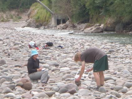
8 Where we are measuring Studies concentrate on intensely measuring several sites, not entire river


9 Big Picture Water Year 2008


 were")
10 Preliminary WY 2009 Bed in motion (winter) Bedload at Brightwood for WY2008 appears to have been about 22% of the load measured below the gorge 36,000 tons vs 160,000 tons Samples collected above the dam (in WY2009) are composed of 60-70% sand, while samples below the former damsite (collected in WY2008) were composed of 85-90% sand
11 WY Several very large flows this winter


12 Preliminary WY 2009 Bed at rest (summer) Downstream of dam
13 Preliminary WY 2009 Bed at rest (summer) Still very active during large storms Upstream of gorge July 9, 2008

14 Preliminary WY 2009 Bed at rest (summer) Still very active during large storms Upstream of gorge Nov 17, 2008

15 Preliminary WY 2009 Bed at rest (summer) Still very active during large storms Upstream of gorge Jan 10, 2009

16 Preliminary WY 2009 Bed at rest (summer) Still very active during large storms Upstream of gorge July 8, 2009
17 Preliminary WY 2009 Bed at rest (summer) Still very active during large storms Upstream of gorge July 9, 2008


18 Preliminary WY 2009 Bed at rest (summer) Upstream of gorge July 2007 July 2009

 2007 2008 2009 10 BI MI UI")
19 Preliminary WY 2009 Bed at rest (summer) Downstream of gorge fs (2ft) BI MI UI Total D50 gravel (2ft) BI MI UI Total

")

20 Preliminary WY 2009 July 2007 Bed at rest (summer) Downstream of gorge July 2008 July 2009

21 Preliminary WY 2009 Oxbow Park near Gordon Creek Photo: fall banks 2008 banks 2009 banks

22 Preliminary WY 2009 Oxbow Park near Gordon Creek Photo: fall banks
23 Near the dam So what? large amount of deposition still shifting seems normal for the Sandy Revenue area some small changes in bars and texture no massive changes hard to distinguish between effects of dam removal versus large storms Downstream (Dodge, Oxbow, Dabney, etc ) sand moving through but what s different dynamic but is it Marmot related?
24 What s Next GMA survey July 2009 DEA / PGE survey Sediment sampling winter JHU/NCED/GMA July 2010 Ongoing USGS / PSU work upstream
25 Acknowledgements Field Assistants: Daniela Martinez, Viviano Berrios, Ramsey Coronado, Carl Ekstrand, Michaela Long, Dajana Jurk, Cecilia Palomo, Katie Trifone, Kim Devillier, Tim Shin, Kimber Cooks, Diana Di Leonardo, Kiernan Folz Donahue, Gabriel Richarde, Jessica Roark, Kristen Sweeney Rose Wallick, Jon Major, Mackenzie Keith, Charlie Cannon, Rachael Peavler, Rebecca Collins USGS Gordon Grant OSU/USFS Connie Athman - USFS Dave Heintzman, John Esler, Tony Dentel, Tim Keller - PGE Bill Doran Metro Parks Greg Stewart, Barbara Burkholder Funding National Center for Earth Surface Dynamics US Forest Service Oregon Watershed Enhancement Board
26 For More files/podolak_marmot_dam_project.html Chuck Podolak, Johns Hopkins (208) Russ Plaeger, Sandy River Basin Watershed Council (503) Smokey Pittman, Graham Matthews & Associates (530)
Stop 1: Marmot Dam Stop 1: Marmot Dam
 Stop 1: Marmot Dam Stop 1: Marmot Dam Following the removal of Marmot Dam in 2007, the fate of the reservoir sediments has been monitored through a series of surveys and sediment transport measurements.
MARMOT DAM REMOVAL GEOMORPHIC MONITORING & MODELING PROJECT
 MARMOT DAM REMOVAL GEOMORPHIC MONITORING & MODELING PROJECT ANNUAL REPORT June 2008 May 2009 Prepared for: Sandy River Basin Watershed Council PO Box 868 Sandy OR 97055 Prepared by: Charles Podolak Johns
PREDICTING SEDIMENT ROUTING ON THE SANDY RIVER, OREGON FOLLOWING THE REMOVAL OF THE MARMOT DAM
 PREDICTING SEDIMENT ROUTING ON THE SANDY RIVER, OREGON FOLLOWING THE REMOVAL OF THE MARMOT DAM Charles J.P. Podolak, Department of Geography and Environmental Engineering, The Johns Hopkins University,
Evaluation of Geomorphic Effects of Removal of Marmot and Little Sandy Dams and Potential Impacts on Anadromous Salmonids
 PRELIMINARY FINAL Evaluation of Geomorphic Effects of Removal of Marmot and Little Sandy Dams and Potential Impacts on Anadromous Salmonids Prepared for: Portland General Electric 121 SW Salmon Street
Squaw Creek. General Information
 General Information is a tributary to the Salmon River. It enters the north side of the river about 0 miles downstream of North Fork, Idaho. The study reach is about a 30 ft length of stream about 2 miles
Linking place, process and strategy: Basin-scale view of salmon and steelhead habitats and restoration projects in the Willamette Valley
 Linking place, process and strategy: Basin-scale view of salmon and steelhead habitats and restoration projects in the Willamette Valley Rose Wallick, James White, Mackenzie Keith, Krista Jones, Gabe Gordon,
SCOPE OF PRESENTATION STREAM DYNAMICS, CHANNEL RESTORATION PLANS, & SEDIMENT TRANSPORT ANALYSES IN RELATION TO RESTORATION PLANS
 DESIGN METHODS B: SEDIMENT TRANSPORT PROCESSES FOR STREAM RESTORATION DESIGN PETER KLINGEMAN OREGON STATE UNIVERSITY CIVIL ENGINEERING DEPT., CORVALLIS 2 ND ANNUAL NORTHWEST STREAM RESTORATION DESIGN SYMPOSIUM
Subcommittee on Sedimentation Draft Sediment Analysis Guidelines for Dam Removal
 Subcommittee on Sedimentation Draft Sediment Analysis Guidelines for Dam Removal August 4, 2011 Jennifer Bountry, M.S., P.E. Tim Randle, M.S., P.E., D.WRE. Blair Greimann, Ph.D., P.E. Sedimentation and
CR AAO Bridge. Dead River Flood & Natural Channel Design. Mitch Koetje Water Resources Division UP District
 CR AAO Bridge Dead River Flood & Natural Channel Design Mitch Koetje Water Resources Division UP District Old County Road AAO Bridge Map courtesy of Marquette County Silver Lake Basin McClure Basin
Numerical Modeling of Sediment Transport in the Sandy River, OR Following Removal of Marmot Dam
 Supplement to Environmental Assessment for the Bull Run Hydroelectric Project FERC Project No. 477 Numerical Modeling of Sediment Transport in the Sandy River, OR Following Removal of Marmot Dam Technical
San Joaquin River Tributary Sediment Transport and Geomorphology Study
 Study 22 San Joaquin River Tributary Sediment Transport and Geomorphology Study Public Draft 2013 Monitoring and Analysis Plan September 2012 22.0 San Joaquin River Tributary Sediment Transport and Geomorphology
Field Methods to Determine/ Verify Bankfull Elevation, XS Area & Discharge
 Module # 6 Field Methods to Determine/ Verify Bankfull Elevation, XS Area & Discharge Iowa s River Restoration Toolbox Level 1 / Base Training Overview of Basic Field Data Collection Site Map Cross Sections
LIDAR ASSESSMENT OF SEDIMENT TRANSPORT RELATED TO THE REMOVAL OF THE MARMOT DAM, SANDY RIVER, OREGON. A Thesis. Presented to. The Graduate Faculty
 LIDAR ASSESSMENT OF SEDIMENT TRANSPORT RELATED TO THE REMOVAL OF THE MARMOT DAM, SANDY RIVER, OREGON A Thesis Presented to The Graduate Faculty Central Washington University In Partial Fulfillment of the
Unconventional Wisdom and the Effects of Dams on Downstream Coarse Sediment Supply. Byron Amerson, Jay Stallman, John Wooster, and Derek Booth
 Unconventional Wisdom and the Effects of Dams on Downstream Coarse Sediment Supply 3 February 2009 Byron Amerson, Jay Stallman, John Wooster, and Derek Booth Sultan River, WA OBJECTIVE Consider the landscape
Big Wood River. General Information
 General Information The flows out of the southern portion of the Sawtooth National Recreation Area in central Idaho. The study reach is about a,200 ft length of river about.5 miles upstream from the discontinued
Can fluvial-hydraulic models accurately predict bed load transport in gravel bed streams?
 Can fluvial-hydraulic models accurately predict bed load transport in gravel bed streams? Scott B. Katz 1,2, Catalina Segura 1,2 1 Water Resources Graduate Program, 2 Department of Forest Engineering,
Great Lakes Tributary Modeling: Canaseraga Creek Watershed
 Great Lakes Tributary Modeling: Canaseraga Creek Watershed SWAT Model Authority: Section 516(e) of WRDA 1996 US Army Corps of Engineers Canaseraga Creek Project Location - Encompasses portions of Livingston,
Sandy River near Oxbow Park
 Sandy River near Oxbow Park Gresham surface Camp Collins Missoula flood sediment over Gresham? Late Holocene Mt. Hood deposits Estacada surface Springwater surface 0 0.5 1 Kilometers 0 0.5 1 Miles Base
What discharge (cfs) is required to entrain the D 84 (84 th percentile of sediment size distribution) in Red Canyon Wash?
 is required to entrain the D 84 (84 th percentile of sediment size distribution) in Red Canyon Wash?") Gregory Indivero 31 October 2011 What discharge (cfs) is required to entrain the D 84 (84 th percentile of sediment size distribution) in Red Canyon Wash? What discharge was required to deposit observed
Gregory Indivero 31 October 2011 What discharge (cfs) is required to entrain the D 84 (84 th percentile of sediment size distribution) in Red Canyon Wash? What discharge was required to deposit observed
Fine sediment in pools: an index of how sediment is affecting a stream channel
 R-5 Fish Habitat Relationship Technical Bulletin Number 6 December 1991 O Fine sediment in pools: an index of how sediment is affecting a stream channel Tom Lisle Sue Hilton Redwood Sciences Laboratory
Geomorphology Geology 450/750 Spring Fluvial Processes Project Analysis of Redwood Creek Field Data Due Wednesday, May 26
 Geomorphology Geology 450/750 Spring 2004 Fluvial Processes Project Analysis of Redwood Creek Field Data Due Wednesday, May 26 This exercise is intended to give you experience using field data you collected
Bank Erosion and Morphology of the Kaskaskia River
 Bank Erosion and Morphology of the Kaskaskia River US Army Corps Of Engineers St. Louis District Fayette County Soil and Water Conservation District Team Partners : Carlyle Lake Ecosystem Partnership Vicinity
Elwha River response to dam removals through four years and a big flood:
 Elwha River response to dam removals through four years and a big flood: Lessons learned, channel response, and sediment effects from the world s largest engineered dam removal Andy Ritchie NPS Elwha Restoration
Do you think sediment transport is a concern?
 STREAM RESTORATION FRAMEWORK AND SEDIMENT TRANSPORT BASICS Pete Klingeman 1 What is Your Restoration Project Like? k? Do you think sediment transport is a concern? East Fork Lewis River, WA Tidal creek,
Quantifying and Valuing Floodplain Nutrient and Sediment Retention
 Quantifying and Valuing Floodplain Nutrient and Sediment Retention Krissy Hopkins, Dianna Hogan, Emily Pindilli, Greg Noe, Fabiano Franco, and Stephanie Gordon A Community on Ecosystem Services December
Tom Glass, B.S. Whitman College Sarah Wasssmund, B.S. Humboldt State University Edgar Verdin, B.S. Portland State University Kelsi Lakey, B.S.
 Tom Glass, B.S. Whitman College Sarah Wasssmund, B.S. Humboldt State University Edgar Verdin, B.S. Portland State University Kelsi Lakey, B.S. Washington State University Overview 1. Background 2. History
Channel responses to the removal of Gold Ray and Savage Rapids Dam. Prepared by Desirée Tullos and Cara Water
 Channel responses to the removal of Gold Ray and Savage Rapids Dam Prepared by Desirée Tullos and Cara Water Introduction. As the results of extensive efforts over several decades, the Rogue River is now
Step 5: Channel Bed and Planform Changes
 Step 5: Channel Bed and Planform Changes When disturbed, streams go through a series of adjustments to regain equilibrium with the flow and sediment supply of their watersheds. These adjustments often
Upper Truckee River Restoration Lake Tahoe, California Presented by Brendan Belby Sacramento, California
 Upper Truckee River Restoration Lake Tahoe, California Presented by Brendan Belby Sacramento, California Mike Rudd (Project Manager), Charley Miller & Chad Krofta Declines in Tahoe s Water Clarity The
Assessment of the Hood River Delta Hood River, Oregon
 Assessment of the Hood River Delta Hood River, Oregon Pacific Northwest Waterways Association Annual Meeting October 13, 2010 Michael McElwee, Executive Director Port of Hood River Overview U.S. Army Corps
Thinking Outside the Box (Culvert) Making difficult decisions for Fish Passage. Dave Stewart Oregon Department of Fish and Wildlife
 Making difficult decisions for Fish Passage. Dave Stewart Oregon Department of Fish and Wildlife") Thinking Outside the Box (Culvert) Making difficult decisions for Fish Passage Dave Stewart Oregon Department of Fish and Wildlife Overview Fish Passage History Fast Version Where are we at Now Approval
Thinking Outside the Box (Culvert) Making difficult decisions for Fish Passage Dave Stewart Oregon Department of Fish and Wildlife Overview Fish Passage History Fast Version Where are we at Now Approval
Field Trip Number One. By: Pat Dryer. Geography 360
 Field Trip Number One By: Pat Dryer Geography 360 Table of Contents Introduction. Page 1 Stop One... Page 2 Stop Two... Page 4 Stop Three... Page 5 Stop Four... Page 7 Bibliography Page 8 Campus Map Source:
Remaining Capacity in Great Lakes Reservoirs
 US Army Corps of Engineers Detroit District Remaining Capacity in Great Lakes Reservoirs Storage Capacity Behind Great Lakes Dams Field Data and Modeling Motivation for project Project overview Data and
Why Geomorphology for Fish Passage
 Channel Morphology - Stream Crossing Interactions An Overview Michael Love Michael Love & Associates mlove@h2odesigns.com (707) 476-8938 Why Geomorphology for Fish Passage 1. Understand the Scale of the
River Bed Monitoring for Change Detection below Marmot Dam in the Sandy River, Oregon. By: Berrios, Viviana. Coronado, Ramsey.
 River Bed Monitoring for Change Detection below Marmot Dam in the Sandy River, Oregon By: Berrios, Viviana Coronado, Ramsey Ekstrand, Carl Long, Michaela Martinez, Daniela National Center for Earth-Surface
Dams, sediment, and channel changes and why you should care
 Dams, sediment, and channel changes and why you should care Gordon E. Grant USDA Forest Service PNW Research Station Corvallis, Oregon Dam effects on river regimes FLOW (Q) SEDIMENT (Qs) TEMP CHEMISTRY
Implementing a Project with 319 Funds: The Spring Brook Meander Project. Leslie A. Berns
 Implementing a Project with 319 Funds: The Spring Brook Meander Project Leslie A. Berns "...to acquire... and hold lands... for the purpose of protecting and preserving the flora, fauna and scenic beauties...
Conceptual Model of Stream Flow Processes for the Russian River Watershed. Chris Farrar
 Conceptual Model of Stream Flow Processes for the Russian River Watershed Chris Farrar Several features of creeks affect the interactions between surface and groundwater. This conceptual model uses the
Strategies for managing sediment in dams. Iwona Conlan Consultant to IKMP, MRCS
 Strategies for managing sediment in dams Iwona Conlan Consultant to IKMP, MRCS 1 Sediment trapping by dams Active storage capacity Dead storage coarse material (bed load) Fine materials (suspension) Francis
Stream Geomorphology. Leslie A. Morrissey UVM July 25, 2012
 Stream Geomorphology Leslie A. Morrissey UVM July 25, 2012 What Functions do Healthy Streams Provide? Flood mitigation Water supply Water quality Sediment storage and transport Habitat Recreation Transportation
Sediment Transport Analysis for Stream Restoration Design: The Good, the Bad, and the Ugly.
 Sediment Transport Analysis for Stream Restoration Design: The Good, the Bad, and the Ugly. Brett Jordan Phd, PE HydroGeo Designs LLC. Land and Water Services Inc. THE GOOD THE BAD THE UGLY THE GOOD THE
Limitation to qualitative stability indicators. the real world is a continuum, not a dichotomy ~ 100 % 30 % ~ 100 % ~ 40 %
 Stream Stability Assessment & BEHI Surveys Joe Rathbun MDEQ Water Resources Division rathbunj@michigan.gov 517--373 517 373--8868 Stability Stream can transport its water and sediment inputs without changing
Gold Ray Dam Removal Monitoring: OSU Summary. Prepared by Desiree Tullos and Cara Walter
 Gold Ray Dam Removal Monitoring: OSU Summary Prepared by Desiree Tullos and Cara Walter December 11, 2012 Data Collection Data collection by Oregon State University consisted of three components on approximately
Diagnostic Geomorphic Methods for Understanding Future Behavior of Lake Superior Streams What Have We Learned in Two Decades?
 Diagnostic Geomorphic Methods for Understanding Future Behavior of Lake Superior Streams What Have We Learned in Two Decades? Faith Fitzpatrick USGS WI Water Science Center, Middleton, WI fafitzpa@usgs.gov
Science affects the way we think together. A RAVENOUS RIVER RECLAIMS ITS TRUE COURSE: THE TALE OF MARMOT DAM S DEMISE
 PNW Pacific Northwest Research Station Inside Planning for an Unprecedented Dam Removal... 2 Anticipating the River s Appetite... 3 A Spectacular Event... 4 The Aftermath... 5 F I N D I N G S issue one
Solutions to Flooding on Pescadero Creek Road
 Hydrology Hydraulics Geomorphology Design Field Services Photo courtesy Half Moon Bay Review Solutions to Flooding on Pescadero Creek Road Prepared for: San Mateo County Resource Conservation District
Diego Burgos. Geology 394. Advisors: Dr. Prestegaard. Phillip Goodling
 Sediment Transport into an Urban Tributary Junction Diego Burgos Geology 394 Advisors: Dr. Prestegaard Phillip Goodling 1 Abstract Tributary junctions are an important component of stream morphology and
Geomorphic Importance of Winter Peak Flows and Annual Snowmelt Hydrographs in a Sierra Nevada Boulder-Bedrock River
 Geomorphic Importance of Winter Peak Flows and Annual Snowmelt Hydrographs in a Sierra Nevada Boulder-Bedrock River Scott McBain and Bill Trush McBain & Trush, Inc. Clavey River and Cherry Creek vicinity
How Do Human Impacts and Geomorphological Responses Vary with Spatial Scale in the Streams and Rivers of the Illinois Basin?
 How Do Human Impacts and Geomorphological Responses Vary with Spatial Scale in the Streams and Rivers of the Illinois Basin? Bruce Rhoads Department of Geography University of Illinois at Urbana-Champaign
Figure 1. Map of drainages above Beatty s property.
 July 13, 2011, corrected Observations of post-monument Fire flows at, Miller Canyon, Coronado National Forest, July 11 th, 2011 Ann Youberg, AZGS Tom Beatty reported 1.05 of rain at his house on July 10
Watershed concepts for community environmental planning
 Purpose and Objectives Watershed concepts for community environmental planning Dale Bruns, Wilkes University USDA Rural GIS Consortium May 2007 Provide background on basic concepts in watershed, stream,
low turbidity high turbidity
 What is Turbidity? Turbidity refers to how clear the water is. The greater the amount of total suspended solids (TSS) in the water, the murkier it appears and the higher the measured turbidity. Excessive
Restoration Goals TFG Meeting. Agenda
 San Joaquin River Restoration Program Restoration Goals TFG Meeting Reach 2B Update April 28, 2010 Agenda 1. Introductions 2. Program Restoration Goal Context 3. Program Update a) Interim Flows b) EIS/EIR
EAGLES NEST AND PIASA ISLANDS
 EAGLES NEST AND PIASA ISLANDS HABITAT REHABILITATION AND ENHANCEMENT PROJECT MADISON AND JERSEY COUNTIES, ILLINOIS ENVIRONMENTAL MANAGEMENT PROGRAM ST. LOUIS DISTRICT FACT SHEET I. LOCATION The proposed
HEC-RAS Reservoir Transport Simulation of Three Reservoirs in the Lower Susquehanna River Basin. Mike Langland and Ed Koerkle
 HEC-RAS Reservoir Transport Simulation of Three Reservoirs in the Lower Susquehanna River Basin Mike Langland and Ed Koerkle Topics Background / Project Objectives Data Selection - Sediment and Geometric
Simulating dam removal with a 1D hydraulic model: Accuracy and techniques for reservoir erosion and downstream deposition at the Chiloquin Dam removal
 Simulating dam removal with a D hydraulic model: Accuracy and techniques for reservoir erosion and downstream deposition at the Chiloquin Dam removal Desiree Tullos, Matt Cox, Cara Walter Department of
The effectiveness of check dams in controlling upstream channel stability in northeastern Taiwan
 Erosion, Debris Mows and Environment in Mountain Regions (Proceedings of the Chengdu Symposium, July 1992). IAHS Publ. no. 209, 1992. 423 The effectiveness of check dams in controlling upstream channel
Avoiding Geohazards in the Mid-Atlantic Highlands by Using Natural Stream Principles
 Avoiding Geohazards in the Mid-Atlantic Highlands by Using Natural Stream Principles J. Steven Kite, WVU Neal Carte, WVDOT Will Harman, Michael Baker Corp. Donald D. Gray, WVU Photo: W. Gillespie North
Lake Sedimentation Survey of Siloam Springs State Park Lake, Adams County, Illinois
 Contract Report 567 Lake Sedimentation Survey of Siloam Springs State Park Lake, Adams County, Illinois by Richard L. Allgire Office of Sediment & Wetland Studies Prepared for the Illinois Department of
River Restoration and Rehabilitation. Pierre Y. Julien
 River Restoration and Rehabilitation Pierre Y. Julien Department of Civil and Environmental Engineering Colorado State University Fort Collins, Colorado River Mechanics and Sediment Transport Lima Peru
SECTION G SEDIMENT BUDGET
 SECTION G SEDIMENT BUDGET INTRODUCTION A sediment budget has been constructed for the for the time period 1952-2000. The purpose of the sediment budget is to determine the relative importance of different
APPENDIX E. GEOMORPHOLOGICAL MONTORING REPORT Prepared by Steve Vrooman, Keystone Restoration Ecology September 2013
 APPENDIX E GEOMORPHOLOGICAL MONTORING REPORT Prepared by Steve Vrooman, Keystone Restoration Ecology September 2 Introduction Keystone Restoration Ecology (KRE) conducted geomorphological monitoring in
Chapter 3 Erosion in the Las Vegas Wash
 Chapter 3 Erosion in the Las Vegas Wash Introduction As described in Chapter 1, the Las Vegas Wash (Wash) has experienced considerable change as a result of development of the Las Vegas Valley (Valley).
Field Observations and One-Dimensional Flow Modeling of Summit Creek in Mack Park, Smithfield, Utah
 Intermountain Center for River Rehabilitation and Restoration, Utah State University 31 July 2018 Field Observations and One-Dimensional Flow Modeling of Summit Creek in Mack Park, Smithfield, Utah I.
DETAILED DESCRIPTION OF STREAM CONDITIONS AND HABITAT TYPES IN REACH 4, REACH 5 AND REACH 6.
 DETAILED DESCRIPTION OF STREAM CONDITIONS AND HABITAT TYPES IN REACH 4, REACH 5 AND REACH 6. The Eklutna River was divided into study reaches (figure 1) prior to this site visit. Prominent geologic or
Coarse Sediment Augmentation on Regulated Rivers. Scott McBain McBain & Trush, Inc.
 Coarse Sediment Augmentation on Regulated Rivers Scott McBain McBain & Trush, Inc. scott@mcbaintrush.com Components Some geomorphic and ecological considerations Conceptual approach at understanding augmentation
Black Gore Creek 2013 Sediment Source Monitoring and TMDL Sediment Budget
 Black Gore Creek 2013 Sediment Source Monitoring and TMDL Sediment Budget Prepared for: Prepared By: - I. Introduction The Black Gore Creek Total Maximum Daily Load (TMDL) was developed in collaboration
Illinois State Water Survey Division
 Illinois State Water Survey Division SURFACE WATER SECTION SWS Miscellaneous Publication 108 SEDIMENT YIELD AND ACCUMULATION IN THE LOWER CACHE RIVER by Misganaw Demissie Champaign, Illinois June 1989
Stream Restoration and Environmental River Mechanics. Objectives. Pierre Y. Julien. 1. Peligre Dam in Haiti (deforestation)
") Stream Restoration and Environmental River Mechanics Pierre Y. Julien Malaysia 2004 Objectives Brief overview of environmental river mechanics and stream restoration: 1. Typical problems in environmental
Stream Restoration and Environmental River Mechanics Pierre Y. Julien Malaysia 2004 Objectives Brief overview of environmental river mechanics and stream restoration: 1. Typical problems in environmental
DESCHUTES RIVER BANK STABILIZATION PROJECTS ASSESSMENT
 DESCHUTES RIVER BANK STABILIZATION PROJECTS ASSESSMENT Prepared for: Deschutes River Conservancy 700 NW Hill Street Bend, Oregon 97701 Prepared by: River Design Group, Inc. 6029 SW 33 rd Place Portland,
Assessment. Assessment
 2001 SPRINGBROOK CREEK RESTORATION - THREE YEAR POST-CONSTRUCTION REVIEW - Presented by Bruce Henderson and Andy Harris 2005 River Restoration Northwest Symposium Skamania Lodge, Washington www.hendersonlandservices.com
Griswold Creek August 22, 2013
 Creek August 22, 2013 1 Lake Erie Protection Fund Creek Study ver Evaluate the overall condition of Creek Determine stable channel dimensions & appropriate restoration techniques Starting Stat gpoint for
Fish Passage and Abundance around Grade Control Structures on Incised Streams in Western Iowa
 Fish Passage and Abundance around Grade Control Structures on Incised Streams in Western Iowa John Thomas Hungry Canyons Alliance Mary Culler Iowa State University / Missouri DNR Dimitri Dermisis IIHR
Beavers in the Built Environment Results From Year One of a Three Year Study Tualatin Watershed, Oregon
 Beavers in the Built Environment Results From Year One of a Three Year Study Tualatin Watershed, Oregon U.S. Department of the Interior U.S. Geological Survey James White U.S. Geological Survey Portland,
Landscape Development
 Landscape Development Slopes Dominate Natural Landscapes Created by the interplay of tectonic and igneous activity and gradation Deformation and uplift Volcanic activity Agents of gradation Mass wasting
Working with Natural Stream Systems
 Working with Natural Stream Systems Graydon Dutcher Delaware County Soil & Water Conservation District Stream Corridor Management Program Tropical Storm Sandy October 29,2012 What is a Watershed?
Stream Simulation: A Simple Example
 Stream Simulation: A Simple Example North Thompson Creek, CO Paul T. Anderson U.S.D.A. Forest Service Here s How We Started May 2011 2-1 USDA-Forest Service Here s How We Finished Forest Service Aquatic
Sedimentation Impacts on California Water Infrastructure
 Sedimentation Impacts on California Water Infrastructure G Mathias Kondolf University of California Berkeley Reclaiming the Sierra, 08 May 2017, Sacramento Rivers carry not only water, but also sediment
1 INTRODUCTION AND MAJOR FINDINGS... 1
 Memorandum To: Lindsey Clark, Stillwater Valley Watershed Council Coordinator From: Chad Raisland, Pioneer Technical Services, Inc. and Karin Boyd, Applied Geomorphology, Inc. CC: Tanya Lester, Stillwater
RESULTS FROM THE TEXAS COASTAL SEDIMENT SOURCES: A GENERAL EVALUATION STUDY
 RESULTS FROM THE TEXAS COASTAL SEDIMENT SOURCES: A GENERAL EVALUATION STUDY JUAN MOYA KELSEY CALVEZ CRIS WEBER ANTHONY RISKO *KEVIN FRENZEL FREESE AND NICHOLS, INC. COASTAL AND WATERWAYS GROUP OBJECTIVES
Reservoir Evolution Following the Removal of. Marmot Dam on the Sandy River, Oregon. Mackenzie Karli Keith
 Reservoir Evolution Following the Removal of Marmot Dam on the Sandy River, Oregon by Mackenzie Karli Keith A thesis submitted in partial fulfillment of the requirements for the degree of Master of Science
GLG362/GLG598 Geomorphology K. Whipple October, 2009 I. Characteristics of Alluvial Channels
 I. Characteristics of Alluvial Channels Self-formed morphology set by entrainment, transport, and deposition They move unconsolidated sedimentary materials present in the valley fill flood plain/bank flow
FORECAST-BASED OPERATIONS AT FOLSOM DAM AND LAKE
 FORECAST-BASED OPERATIONS AT FOLSOM DAM AND LAKE 255 237 237 237 217 217 217 200 200 200 0 163 131 Bridging the Gap163Conference 255 0 132 255 0 163 122 The Dana on Mission Bay San Diego, CA January 28,
Klamath River Dam Removal Study:
 : Prepared for California Coastal Conservancy 1330 Broadway, 13th Floor Oakland, CA 94612 (Contract No. 06-141) Prepared by 2855 Telegraph Ave. Suite 400 Berkeley, CA 94705 Acknowledgement A pre-project
!"#$%&&'()*+#$%(,-./0*)%(!
*+#$%(,-./0*)%(!") 8:30 Sign in Hoosic River Revival Coalition!"#$%&&'()*+#$%(,-./0*)%(! 12-#30+4/#"5-(60 9:00 Welcome and Introductions 9:15 Goals for Today s Program: A Description of the Planning Process 9:30 First Session:
8:30 Sign in Hoosic River Revival Coalition!"#$%&&'()*+#$%(,-./0*)%(! 12-#30+4/#"5-(60 9:00 Welcome and Introductions 9:15 Goals for Today s Program: A Description of the Planning Process 9:30 First Session:
Lectures Hydrology & Fluvial Geomorphology. Gauley River Images. Ancients' (= Biblical) Model of Water (Hydrologic) Cycle
 Model of Water (Hydrologic) Cycle") Lectures 11-13 13 Hydrology & Fluvial Geomorphology Gauley River Images http://www.youtube.com/watch?v=eulmuyegtz4&feature=related Ancients' (= Biblical) Model of Water (Hydrologic) Cycle Stream Water
Lectures 11-13 13 Hydrology & Fluvial Geomorphology Gauley River Images http://www.youtube.com/watch?v=eulmuyegtz4&feature=related Ancients' (= Biblical) Model of Water (Hydrologic) Cycle Stream Water
HAW CREEK, PIKE COUNTY, MISSOURI-TRIB TO SALT RIVER ERODING STREAM THREATHENING COUNTY ROAD #107, FOURTEEN FT TALL ERODING BANK WITHIN 4 FT OF THE
 HAW CREEK, PIKE COUNTY, MISSOURI-TRIB TO SALT RIVER ERODING STREAM THREATHENING COUNTY ROAD #107, FOURTEEN FT TALL ERODING BANK WITHIN 4 FT OF THE ROAD, PROJECT CONSTRUCTED IN 1 DAY, MARCH 10, 2009 BY
Numerical modeling of sediment flushing from Lewis and Clark Lake
 University of Nebraska - Lincoln DigitalCommons@University of Nebraska - Lincoln US Army Research U.S. Department of Defense 2013 Numerical modeling of sediment flushing from Lewis and Clark Lake Jungkyu
Geomorphology Studies
 Geomorphology Studies Technical Workgroup Meeting February 14, 2012 Prepared by: Tetra Tech Prepared for: Alaska Energy Authority Overall Goal Geomorphology Studies Two studies Geomorphology Study (RSP
THE MIDDLE SACRAMENTO RIVER: HUMAN IMPACTS ON PHYSICAL AND ECOLOGICAL PROCESSES ALONG A MEANDERING RIVER 1
 THE MIDDLE SACRAMENTO RIVER: HUMAN IMPACTS ON PHYSICAL AND ECOLOGICAL PROCESSES ALONG A MEANDERING RIVER 1 Koll Buer, Dave Forwalter, Mike Kissel, and Bill Stohler 2 Abstract: Native plant and wildlife
Spring Run Spawning Habitat Assessment Sediment Mobility
 Study 47 Spring Run Spawning Habitat Assessment Sediment Mobility Final 2015 Monitoring and Analysis Plan January 2015 1.0 Spring Run Spawning Habitat Assessment Sediment Mobility Theme(s): Flow management
May 7, Roger Leventhal, P.E. Marin County Public Works Laurel Collins Watershed Sciences
 May 7, 2013 Roger Leventhal, P.E. Marin County Public Works Laurel Collins Watershed Sciences Background Funded in 2009 under EPA 2100 Grant for $30k and managed by SFEP Project Goals: Update original
Assessment of Lake Forest Lake Sediment Trapping Efficiency and Capacity. Marlon R. Cook Groundwater Assessment Program Geological Survey of Alabama
 Assessment of Lake Forest Lake Sediment Trapping Efficiency and Capacity Marlon R. Cook Groundwater Assessment Program Geological Survey of Alabama Impacts of the Lake at Lake Forest on the connectivity
Use of benthic invertebrate biological indicators in evaluating sediment deposition impairment on the Middle Truckee River, California
 Use of benthic invertebrate biological indicators in evaluating sediment deposition impairment on the Middle Truckee River, California David B. Herbst Sierra Nevada Aquatic Research Laboratory University
STREAM RESTORATION AWRA Summer Specialty Conference, GIS and Water Resources IX
 STREAM RESTORATION 2016 AWRA Summer Specialty Conference, GIS and Water Resources IX Innovative Use of 2D Hydraulic Modeling in Stream Restoration Design Presented by: Li Gao, PE and Robert Scrafford,
Restoring the Napa River:
 Restoring the Napa River: lessons learned from a long term private-public project Andy Collison Environmental Science Associates acollison@esassoc.com 1 Napa River Restoration Projects Rutherford Reach
Overview of fluvial and geotechnical processes for TMDL assessment
 Overview of fluvial and geotechnical processes for TMDL assessment Christian F Lenhart, Assistant Prof, MSU Research Assoc., U of M Biosystems Engineering Fluvial processes in a glaciated landscape Martin
Mercury and methylmercury transport in the Cache Creek Settling Basin, California, U.S.A.
 Mercury and methylmercury transport in the Cache Creek Settling Basin, California, U.S.A. Alpers, C.N. 1, Fleck, J.A. 1, Marvin- DiPasquale, M. 2, Beaulieu, E. 1, and Wright, S.A. 1 1 U.S. Geological Survey,
CAUSES FOR CHANGE IN STREAM-CHANNEL MORPHOLOGY
 CAUSES FOR CHANGE IN STREAM-CHANNEL MORPHOLOGY Chad A. Whaley, Department of Earth Sciences, University of South Alabama, MobileAL, 36688. E-MAIL: caw408@jaguar1.usouthal.edu The ultimate goal of this
B-1. Attachment B-1. Evaluation of AdH Model Simplifications in Conowingo Reservoir Sediment Transport Modeling
 Attachment B-1 Evaluation of AdH Model Simplifications in Conowingo Reservoir Sediment Transport Modeling 1 October 2012 Lower Susquehanna River Watershed Assessment Evaluation of AdH Model Simplifications