ESS 315 Seattle Landslides Extra Credit Field Trip March 4, 2006
|
|
|
- Sarah Price
- 5 years ago
- Views:
Transcription
1 ESS 315 Seattle Landslides Extra Credit Field Trip March 4, 2006 NAME: Introduction Today we are going to see some of the landslides in the Magnolia neighborhood of Seattle (Figure 1). We will start the day at Discovery Park and review the local glacial stratigraphy and talk about how the geologic setting increases the landslide risk for the area. We will also discuss the differences between the geology here and at Whidbey Island. Then, we will go to the ground-zero of Seattle landslides: Perkins Lane West. This area, known for expensive view homes and expensive landslide damage, experienced a massive slide during the very wet El Niño winter of (destructive slides have also happened in 1961, 1972, 1980, 1982, 1986, and the spring of 1996). We will walk down a steep staircase and then along a short distance on Perkins Lane and investigate the slide zone first-hand; we will then go to the top of the bluff so we can look at the entire slide area and make some estimates of the retreat rate of the bluff. Finally, we will end the trip at Smith Cove Park/Elliot Bay Marina to look at some of the techniques local homeowners are using to try to stabilize their property. There will be no report to turn in, but we do ask you to participate in this trip and fill out some sections and turn in this handout to get your extra credit. Expectations We will travel together to all the stops. At some of the stops, we will break up into smaller groups to discuss or work out a particular question. At each stop, we will have a whole-group discussion to summarize our observations. For extra credit, you must participate (or at least be present) for all these discussions and turn in this handout. Common sense field trip etiquette: Be aware of where the group is. Make a buddy in your van to decrease the odds that we will leave you at a park or outcrop somewhere. We will be spending a fair bit of time on or near private property. Be respectful and obey No Trespassing signs. Be careful when walking/climbing around the landslide zone at the end of Perkins Lane. Be especially careful to not kick or dislodge rocks or dirt when you are on a slope above other people. If you do kick down a rock, yell a warning so the people below you can get out of the way. 1
 Discovery Park Visitor Center, 2) Discovery Park Beach, 3) Magnolia View Park (with")
2 This map shows all the stops from a longer field trip. We will be stopping at 1) Discovery Park Visitor Center, 2) Discovery Park Beach, 3) Magnolia View Park (with a trip down to Perkins Lane), and 4) Smith Cove Park. 2
3 SCHEDULE Stop 1: Discovery Park Visitor Center We will be stopping here just to pick up parking permits for the beach and to let people use the bathrooms. Stop 2: Discovery Park beach We will then head down to the lighthouse and look at the geology of the bluff from the beach. This is a great location to see the glacial stratigraphy that forms Magnolia Bluff (and many other parts of Seattle). The Guide to glacial sediments below briefly describes the different kinds of sediments created in a glacial or near-glacial environment. Much of this should be a review from Terry s trips the past two weekends. Try to identify the different stratigraphic units seen at the beach, and make a sketch of the stratigraphy. On this sketch, include the topographic profile of the bluff. After we all have a chance to look at this outcrop on our own, we will discuss what this stratigraphy tells us about the history of the advance and retreat of the Puget Lobe over this area. We will use Figure 3 (the map of Puget Sound) to sketch out this advance and retreat. Room for sketch: Guide to glacial sediments 3
: Glaciofluvial deposits ( outwash ).")
4 The sedimentary deposits left by glaciers are highly variable in terms of their sorting and grain size. The following is a list of some of common deposits found in glacial and near-glacial environments (see Figures 2 and 3): Glaciofluvial deposits ( outwash ). Meltwater streams flow out in front of the ice and can re-work sediment deposited by the glacier. Outwash deposits are typically better sorted than tills, and the finest grains are washed away, leaving cross-bedded subrounded to well-rounded sand, gravel, and cobble-sized clasts. Outwash forms in front of advancing and retreating glaciers. The size of the sediment can be a function of the proximity of the glacier (larger clasts closer to the glacier). Till. This is sediment deposited directly by the ice. Till can be smeared out under a glacier as it moves (resulting in an over-compacted till), or can melt out of the ice as it ablates. Till is typically very poorly sorted and has angular grains. There is typically no bedding in tills. Often, tills have a bimodal grain size, with a fine-grained matrix and larger clasts. Imagine a sedimentary deposit like a chocolate chip cookie, with the cookie part being the matrix and the chocolate chips being the clasts. Glaciolacustrine ( pro-glacial lake ) deposits. Glaciers can block streams and create proglacial lakes. Sediment carried into these lakes can then settle out on the bottom. Typically, the coarse grained sediment settles near the edges, where streams enter the lake. Fine-grained sediment (silt and clay) can be carried out and settle in the middle of the lake, where it can form very thin layers (called lamination). Sometimes, sedimentrich icebergs can carry larger clasts out to the middle of a lake, melt, and drop them into the finer-grained sediment. These large clasts found within finer-grained lake sediments are called dropstones. Figure 2. Cross-section view of sediments deposited in front of and below an ice sheet 4
5 Figure 3. Map of Puget Sound 5
6 Stop 3: Perkins Lane We are going to park on Magnolia Blvd. above Perkins Lane and take the stairs down to the landslide area. Five homes in this area were destroyed by landslides in Look at Figure 4, which shows aerial photographs of this area from 1990 (before the most recent slides) and 2002 (after). As you go down the stairs, notice the outcrops on either side. Can you tell what unit this is? At the bottom of the stairs, we will first turn left and investigate the landslide zone. The ground is very uneven and will probably be muddy here, so be careful scrambling around. Divide into groups to answer the following questions: Can you identify any of the stratigraphic units? If not, can you guess where the sand/clay contact is, based on the topography? From the aerial photos, how has the landscape changed between 1990 and today? Can you see any landslide surfaces or blocks? If so, can you estimate the width and thickness? The City of Seattle owns the bluff above this property. In 1996, the city hired a geotechnical firm to assess the landslide risk here. The geotechnical firm recommended that the city install dewatering wells to reduce the water pressure at the base of the sand. Before these wells could be installed, the big destructive slides occurred. One of the homeowners in the destroyed area sued the City of Seattle for failing to stabilize the bluff. Eventually, this lawsuit was dismissed. Do you agree with this decision? When slides initiate in one area and destroy property in another, who is responsible? Should homeowners here be responsible for understanding (and accepting) the risk? 6
7 Next, we will walk north along the still-habitated part of Perkins Lane. Remember, people live here, so please don t enter private property or be obtrusively loud. Spend some time observing the landscape and the construction. Walk as far north as the house at 2409 Perkins Lane, then turn around and come back. What evidence is there for slope instability here? What techniques are people using to stabilize their property? Though the Factor of Safety equation (remember that from the landslide lab?) is not exactly appropriate, elements of the FS equation such as slope, cohesion, internal friction, and saturation are still relevant. How do the different stabilization methods you observe act to reduce the landslide risk of this area? What kinds of things have been done here to actively, but unintentionally, encourage landsliding? Note the locations where people have removed houses from the east (hill) side of the road. In some cases, these homes have been relocated to the west (sound) side of Perkins lane. Was this a wise move? What are the specific risks to the homes on the east vs. west sides of the road? 7

8 Figure 4 8
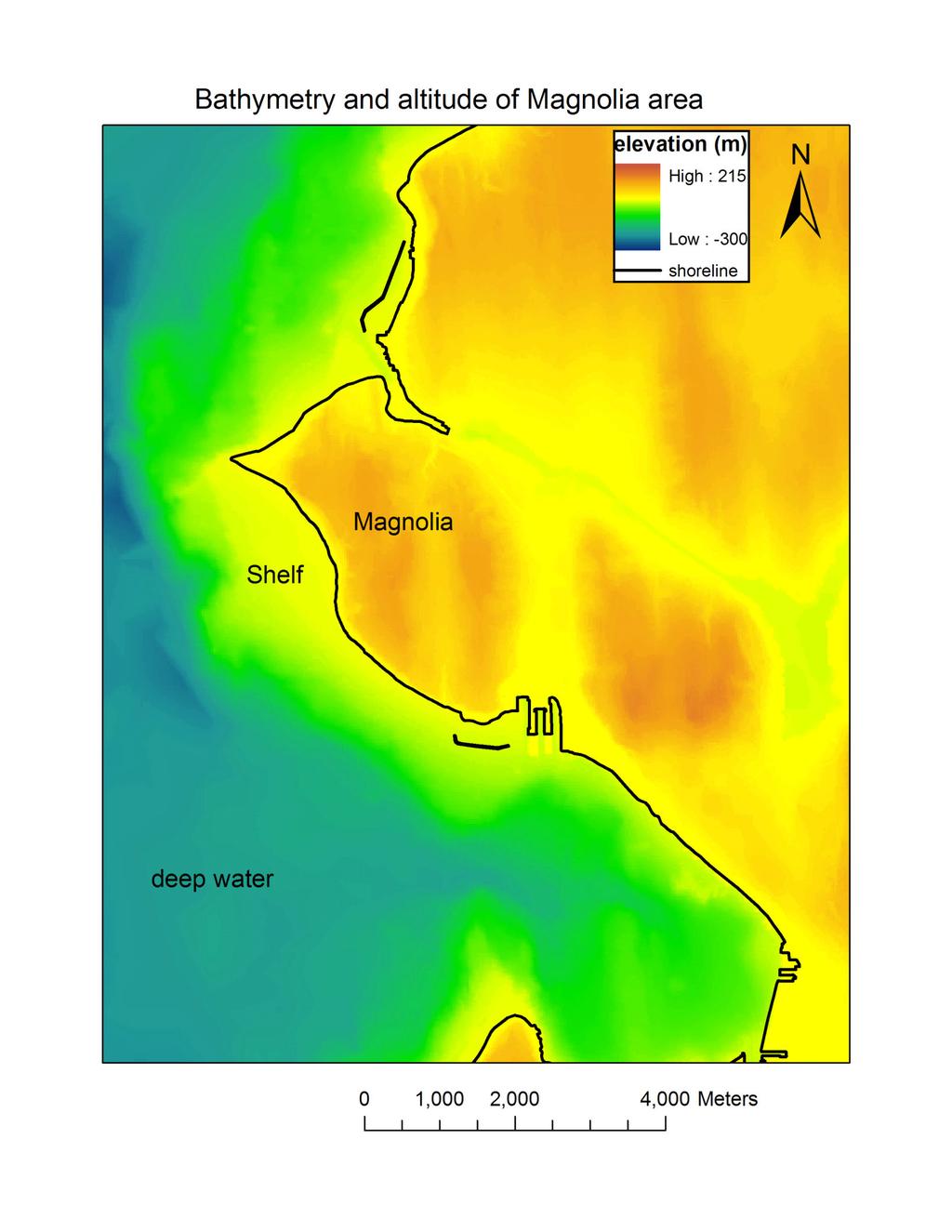
9 Stop 4: Magnolia View Park Now we will climb the stairs again and reconvene at the far south end of the park, where the fence cuts towards the west. Here we can get a bigger view of the landslide area. Notice how close Magnolia Blvd. is to the edge of the bluff. We are going to estimate the retreat rate of this bluff, and figure out how much longer Magnolia Blvd. has to exist. You will get into small groups and spread out along the road to do these calculations. First, look at the bathymetric map shown in Figure 5. Notice the underwater wave-cut platform that extends out from the bottom of the bluff. The extent of this platform shows the size of Magnolia Bluff at approximately 6000 years ago, when sea level stabilized (glaciers had finished melting and the ground had finished rebounding from the unloading of the ice). Since 6000 years ago, the waves of Puget Sound have been cutting away at the hill. Using the width and the age of the platform, estimate the retreat rate of the bluff in feet per year. Now, using the tape measures, find the approximate distance from the edge of the bluff to the street (1 meter = 3.28 feet). PLEASE DO NOT FALL OFF THE CLIFF. Assuming the retreat rate hasn t changed through time, how long until the road is threatened? Show your math. Does the bluff really retreat every year, evenly, at the rate you just calculated? Using the landslide probability map (Figure 6), estimate the recurrence interval of landslides in this area. Estimated recurrence interval: Note that the landslide density contours show the number of landslides that occur in a 4 hectare (400 x 400 m) area, so if you are within the 2-landslide contour, that means 2 historic landslides have occurred somewhere within that 4 hectare region (not necessarily in the same exact spot). See how this corresponds to a recurrence interval of years? Figure 5. Topography and bathymetry of Magnolia Bluff area 9
10 10

11 Figure 6 11
12 Stop 5: Spring Cove Park/Elliot Bay Marina Property with a nice view is expensive and homeowners are willing to pay a substantial amount of money to protect it. Here, we will look at three different landslide mitigation projects (two of them are similar and right next to each other we ll consider them together). We will pay particular attention to what aspect of slope stability each mitigation method tries to address. Project #1. Home at top of grassy hill, near parking lot. How have they modified the landscape here? What elements of slope stability are specifically addressed? What could they do to stabilize this slope even better? Projects #2 and #3. Homes at west edge of bluff What has been done to these slopes, and what elements of the FS equation are addressed? List at least 3 modifications they have made here. Do you think these modifications are a permanent fix? Why or why not? What might you do differently? 12
Clyde River Landslide
 Clyde River Landslide Department of Geology, Perkins Hall, University of Vermont, Burlington, VT 05405 Abstract: This paper investigates a landslide on the Clyde River in Newport, Vermont. The landslide
Lab 11: Discovery Park, glaciation and coastal processes
 Geology 101 Name(s): Lab 11: Discovery Park, glaciation and coastal processes Geomorphology in the Puget Sound area is dominated by three factors: the continental glaciation which carved and dumped the
GEL 109 Midterm W01, Page points total (1 point per minute is a good pace, but it is good to have time to recheck your answers!
 GEL 109 Midterm W01, Page 1 50 points total (1 point per minute is a good pace, but it is good to have time to recheck your answers!) 1. Where in a water flow is there usually a zone of laminar flow even
Erosional Features. What processes shaped this landscape?
 Have you ever looked at the land around you and wondered what processes shaped what you see? Perhaps you see mountains, valleys, rivers, or canyons. Do you know how long these geologic features have been
3 Erosion and Deposition by Ice
 CHAPTER 12 3 Erosion and Deposition by Ice SECTION Agents of Erosion and Deposition BEFORE YOU READ After you read this section, you should be able to answer these questions: What are glaciers? How do
Investigating Factors that Affect Erosion
 Investigating Factors that Affect Erosion On your erosion walk and while you were reading the cases, you may have noticed that the type of soil or other Earth materials can make a difference in how and
Oceanography Field Trip One Key
 Oceanography Field Trip One Key If you are using this key as a make-up guide, you should get a COLOR version of this field trip guide by going to http://www.mpcfaculty.net/alfred_hochstaedter/oceanography.htm
depression above scarp scarp
 1 LAB 1: FIELD TRIP TO McKINLEYVILLE AND MOUTH OF THE MAD RIVER OBJECTIVES: a. to look at geomorphic and geologic evidence for large scale thrust-faulting of young sediments in the Humboldt Bay region
Weathering and Erosion
 Have you ever looked at the land around you and wondered how it was shaped? The geologic features that help define the world are still being shaped by the natural processes of weathering, erosion, and
EROSIONAL FEATURES. reflect
 reflect Have you ever looked at the land around you and wondered what processes shaped what you see? Perhaps you see mountains, valleys, rivers, or canyons. Do you know how long these geologic features
Vantage/Columbia Basin Field Trip
 Geology 152 Name Vantage/Columbia Basin Field Trip The primary goal of this course is to help you see the Earth from a different perspective a geological one. To accomplish this goal you will be expected
Field Trip to Tempe Butte
 Synopsis Field Trip to Tempe Butte So far you have been identifying rocks and mapping their locations without actually going there. Now it is your chance to put it all together and see real rocks out in
1. Which type of climate has the greatest amount of rock weathering caused by frost action? A) a wet climate in which temperatures remain below
 a wet climate in which temperatures remain below") 1. Which type of climate has the greatest amount of rock weathering caused by frost action? A) a wet climate in which temperatures remain below freezing B) a wet climate in which temperatures alternate
1. Which type of climate has the greatest amount of rock weathering caused by frost action? A) a wet climate in which temperatures remain below freezing B) a wet climate in which temperatures alternate
Science in the Schoolyard Guide: FOSS California Solid Earth
 Soild Earth Solid Earth > Investigation 5: Landforms > Part 2: Erosion, page 190 and Part 3: Deposition, page 199 Erosion and Deposition Parts 2 and 3 may be conducted outdoors. Refer to page 190 (Part
Lowland Glaciation North Wales
 Lowland Glaciation North Wales Background Although there have been many glaciations and advances in ice, the most significant for this are was the Dimlington Stadial which was a period of glacial advance
SAMPLE Earth science BOOSTERS CARDS. Copyright Regents Boosters 2013 EARTH SCIENCE BOOSTERS 1
 SAMPLE Earth science BOOSTERS CARDS Copyright Regents Boosters 2013 EARTH SCIENCE BOOSTERS 1 Here is a selection from Earth Science Boosters on Deposition. Copyright Regents Boosters 2013 EARTH SCIENCE
Sandy Point Beach, Cousins Island, Yarmouth, Maine
 Maine Geologic Facts and Localities April, 2008 Sandy Point Beach, Cousins Island, Yarmouth, Maine 43 o 46 25.46 N, 70 o 8 44.84 W Text by Tom Weddle, Department of Agriculture, Conservation & Forestry
Waterbury Dam Disturbance Mike Fitzgerald Devin Rowland
 Waterbury Dam Disturbance Mike Fitzgerald Devin Rowland Abstract The Waterbury Dam was completed in October 1938 as a method of flood control in the Winooski Valley. The construction began in April1935
Sorting of Earth s Materials: Beaches, Streams and Road Cuts.
 Sorting of Earth s Materials: Beaches, Streams and Road Cuts. What is Sorting? Sorting is arranging things according to class, kind, or size; classify. Density affects the sorting of natural materials
Topic 6: Weathering, Erosion and Erosional-Deposition Systems (workbook p ) Workbook Chapter 4, 5 WEATHERING
 Workbook Chapter 4, 5 WEATHERING") Topic 6: Weathering, Erosion and Erosional-Deposition Systems (workbook p. 95-125) Workbook Chapter 4, 5 THE BIG PICTURE: Weathering, erosion and deposition are processes that cause changes to rock material
Topic 6: Weathering, Erosion and Erosional-Deposition Systems (workbook p. 95-125) Workbook Chapter 4, 5 THE BIG PICTURE: Weathering, erosion and deposition are processes that cause changes to rock material
Erosion and Deposition
 Erosion and Deposition The Erosion-Deposition Process What do you think? Read the two statements below and decide whether you agree or disagree with them. Place an A in the Before column if you agree with
Landslides and Ground Water Permeability with Respect to the. Contact Point of Glacial Lake Vermont and the Champlain Sea
 Landslides and Ground Water Permeability with Respect to the Contact Point of Glacial Lake Vermont and the Champlain Sea Sediments at Town Line Brook, Winooski, VT Michala Peabody Lara Vowles Abstract:
GEOL 380: Earthquake Hazards in the Puget Sound Region (in class and assignment) Due in class Wednesday, Nov 109th
 Due in class Wednesday, Nov 109th") GEOL 380: Earthquake Hazards in the Puget Sound Region (in class and assignment) Due in class Wednesday, Nov 109th The purpose of this exercise/assignment is for you to gain practice and experience in
GEOL 380: Earthquake Hazards in the Puget Sound Region (in class and assignment) Due in class Wednesday, Nov 109th The purpose of this exercise/assignment is for you to gain practice and experience in
GLG Chapter 7 Sedimentary Environments & Rocks
 GLG 101 - Chapter 7 Sedimentary Environments & Rocks Name Note, Oct 11: I ll be writing this study sheet over the next few days. Each day I will add questions until the entire chapter is done, hopefully
Draft exercise for share fair at Bozeman workshop only. This exercise is not ready for distribution. Please send helpful suggestions to
 Draft exercise for share fair at Bozeman workshop only. This exercise is not ready for distribution. Please send helpful suggestions to foleyd@plu.edu Figure list 1. Trailer photograph 2. Location map
Name. 4. The diagram below shows a soil profile formed in an area of granite bedrock. Four different soil horizons, A, B, C, and D, are shown.
 Name 1. In the cross section of the hill shown below, which rock units are probably most resistant to weathering? 4. The diagram below shows a soil profile formed in an area of granite bedrock. Four different
The Geology of Sebago Lake State Park
 Maine Geologic Facts and Localities September, 2002 43 55 17.46 N, 70 34 13.07 W Text by Robert Johnston, Department of Agriculture, Conservation & Forestry 1 Map by Robert Johnston Introduction Sebago
Gradualism versus Catastrophism Curriculum written by XXXXX
 Gradualism versus Catastrophism Curriculum written by XXXXX A curriculum written with the goal of educating 8 th grade science students on the difference between gradual and cataclysmic geological events
Field Trip 1 Tunnel Mill, Vernon, Indiana: Waldron Shale
 Geol G308 Paleontology and Geology of Indiana Name: Field Trip 1 Tunnel Mill, Vernon, Indiana: Waldron Shale On this trip we will visit Tunnel Mill, which is located just south of Vernon, Indiana in the
13. Sedimentary Rocks I (p )
") 13. Sedimentary Rocks I (p. 194-208) Sediment Deposition Weathering results in rock being broken down into smaller fragments, called regolith. This regolith is then broken down to form soil. The regolith
13. Sedimentary Rocks I (p. 194-208) Sediment Deposition Weathering results in rock being broken down into smaller fragments, called regolith. This regolith is then broken down to form soil. The regolith
We will provide: hammers (one per group), hard hats, shovels, paper bags or boxes for pebble collections, map boards, and compasses, measuring tapes.
, hard hats, shovels, paper bags or boxes for pebble collections, map boards, and compasses, measuring tapes.") Geology 110 Spring 1999 Northfield Topography and Field Trip to Little Chicago This lab has two parts. After the spot test on the geologic time scale, we will spend the next few hours at a gravel pit near
Geology 110 Spring 1999 Northfield Topography and Field Trip to Little Chicago This lab has two parts. After the spot test on the geologic time scale, we will spend the next few hours at a gravel pit near
The Lee River Landslide
 The Lee River Landslide Meghan O'Donnell Jon Bevan Geomorphology December 5, 2003 Abstract: Steep hillslopes that lie adjacent to active stream channels are prone to landsliding. Glaciolacustrine material
Earthquake Lab! Seismic Waves 1. What do scientists believe the Earth is made of?
 Name: Earthquake Lab! Seismic Waves 1. What do scientists believe the Earth is made of? Period: 2. How do scientists make measurements of inside the Earth? 3. What are the two types of Earthquake waves?
EROSION RATES (1 Hour)
") EROSION RATES (1 Hour) Addresses NGSS Level of Difficulty: 2 Grade Range: 3-5 OVERVIEW In this activity, students will conduct simple investigations to collect data on erosion rates of different Earth
EROSION RATES (1 Hour) Addresses NGSS Level of Difficulty: 2 Grade Range: 3-5 OVERVIEW In this activity, students will conduct simple investigations to collect data on erosion rates of different Earth
What are the different ways rocks can be weathered?
 Romano - 223 What are the different ways rocks can be weathered? Weathering - the breakdown of rocks and minerals at the Earth s surface 1. 2. PHYSICAL WEATHERING Rock is broken into smaller pieces with
1. Any process that causes rock to crack or break into pieces is called physical weathering. Initial product = final product
 Weathering 1. Any process that causes rock to crack or break into pieces is called physical weathering. Initial product = final product End Result of physical weathering is increased surface area. 2. Physical
Appendix F4.11 Geologic Unit Summaries, Hazard Areas, and Boring Locations
 Appendix F4.11 Geologic Unit Summaries, Hazard Areas, and Boring Locations Appendix F4.11 Geologic Unit Summaries and Hazard Areas TABLE F4.11-1 Summary of Geologic Units and their Engineering Properties
EPS 50 - Lab 10: Groundwater Flow and Glaciers
 Name: EPS 50 - Lab 10: Groundwater Flow and Glaciers Part 1: Groundwater Flow Part 2: Darcy s Law Part 3: Glacial Deposits and Flow -Chapter 17, p. 478-492: Hydrology of Groundwater -Chapter 17, p. 485-486:
Erosion and Deposition along Rivers and Seashores - Part 1: Modeling in the Classroom
 Erosion and Deposition along Rivers and Seashores - Part 1: Modeling in the Classroom Lesson Focus: Erosion and Deposition Learning Objectives: Students will learn to recognize landforms found on Earth.
SLOPE PROCESSES, LANDSLIDES, AND SUBSIDENCE
 CHAPTER 9 SLOPE PROCESSES, LANDSLIDES, AND SUBSIDENCE La Conchita slide January 10, 2005 Triggered by heavy rainfall, reactivation along an older landslide surface (35,000 years ago, 6000 years ago, and
Summer 2014 Reading the Geologic History of Doheny State Beach Rodger More LAYERS LET S TAKE A TOUR THE BLUFFS
 Summer 2014 Reading the Geologic History of Doheny State Beach Rodger More DSBIA Board Officer and Geologist (retired) LAYERS of sediment and rock are like a book. Formations make up chapters and individual
C E C U R R I C U L U M I E N S C B L E I T A. i N T E G R A T I N G A R T S i n O N A T I D U C B L I P U. Student Learning Objectives:
 Sedimentation E Q U I T A B L E S C I E N C E C U R R I C U L U M Lesson 3 i N T E G R A T I N G A R T S i n P U B L I C E D U C A T I O N NGSS Science Standard: 4-ESS1-1 Identify evidence from patterns
Map reading made easy
 Map reading made easy 1. What is a map? A map is simply a drawing or picture (in 2-D) of a landscape or area of a country (in 3-D). It could be anything from a sketch map for a visitor to find your school
Map reading made easy
 Map reading made easy Maps can be great fun and they can lead you to all sorts of discoveries. They can help you get to know an area really well, because they pinpoint interesting places that are often
Sedimentary Rocks, our most Valuable Rocks. Or, what you will probably find when you are outdoors exploring.
 Sedimentary Rocks, our most Valuable Rocks Or, what you will probably find when you are outdoors exploring. Sedimentary rocks give us evidence to earth s earlier history. We look at processes happening
American Institute of Professional Geologists South Dakota Section
 American Institute of Professional Geologists South Dakota Section 2015 Field Trip Guide Deadwood Formation in the Black Hills of South Dakota and Frac Sand Potential Saturday, September 12, 2015 1 Field
Grade 5 Hands on Science Weathering, Erosion and Deposition
 Grade 5 Hands on Science Weathering, Erosion and Deposition Objective: To demonstrate and investigate the effect of weathering, water and wind erosion and the subsequent deposition into landforms. Background:
Mass Wasting. Revisit: Erosion, Transportation, and Deposition
 Mass Wasting Revisit: Erosion, Transportation, and Deposition While landslides are a normal part of erosion and surface processes, they can be very destructive to life and property! - Mass wasting: downslope
4. The map below shows a meandering stream. Points A, B, C, and D represent locations along the stream bottom.
 1. Sediment is deposited as a river enters a lake because the A) velocity of the river decreases B) force of gravity decreases C) volume of water increases D) slope of the river increases 2. Which diagram
SEDIMENTS can have different sizes and we can sort them using standard sieves. What size mesh is each sieve?
 SEDIMENTS can have different sizes and we can sort them using standard sieves What size mesh is each sieve? Streams are the most obvious sculptors of the earth, weathering and eroding the Earth and causing
How do glaciers form?
 Glaciers What is a Glacier? A large mass of moving ice that exists year round is called a glacier. Glaciers are formed when snowfall exceeds snow melt year after year Snow and ice remain on the ground
Earth processes are dynamic actions that occur both on
 29 Weathering, Erosion, and Deposition R EA D I N G Earth processes are dynamic actions that occur both on the earth s surface and inside the earth. Any process that breaks down earth material, such as
Geology and New England Landscapes
 Geology and New England Landscapes Jim Turenne, CPSS USDA-NRCS Warwick, RI. http://nesoil.com Why Geology? Provides the big picture of site conditions. Major part of soil formation (parent material and
CURRICULUM TR AILING ICE AGE M YST ERI E S
 MIDDLE SCHOOL CURRICULUM TR AILING ICE AGE M YST ERI E S THE Driftless Area CONTENTS I. Enduring Knowledge... 3 II. Teacher Background... 3 III. Before Viewing the Video... 5 IV. Viewing Guide... 5 V.
CARD #1 The Shape of the Land: Effects of Crustal Tilting
 CARD #1 The Shape of the Land: Effects of Crustal Tilting When we look at a birds-eye view of the Great Lakes, it is easy to assume the lakes are all at a similar elevation, but viewed in this way, we
Name: Which rock layers appear to be most resistant to weathering? A) A, C, and E B) B and D
 A, C, and E B) B and D") Name: 1) The formation of soil is primarily the result of A) stream deposition and runoff B) precipitation and wind erosion C) stream erosion and mass movement D) weathering and biological activity 2)
Name: 1) The formation of soil is primarily the result of A) stream deposition and runoff B) precipitation and wind erosion C) stream erosion and mass movement D) weathering and biological activity 2)
3.12 Geology and Topography Affected Environment
 3 Affected Environment and Environmental Consequences 3.12 Geology and Topography 3.12.1 Affected Environment 3.12.1.1 Earthquakes Sterling Highway MP 45 60 Project Draft SEIS The Kenai Peninsula is predisposed
Biosphere. All living things, plants, animals, (even you!) are part of the zone of the earth called the biosphere.
 are part of the zone of the earth called the biosphere.") Unit 1 Study Guide Earth s Spheres Biosphere All living things, plants, animals, (even you!) are part of the zone of the earth called the biosphere. Hydrosphere Water covers ¾ of the earth, made up mostly
Unit 1 Study Guide Earth s Spheres Biosphere All living things, plants, animals, (even you!) are part of the zone of the earth called the biosphere. Hydrosphere Water covers ¾ of the earth, made up mostly
Glaciers form wherever snow and ice can accumulate High latitudes High mountains at low latitudes Ice temperatures vary among glaciers Warm
 The Cryosphere Glaciers form wherever snow and ice can accumulate High latitudes High mountains at low latitudes Ice temperatures vary among glaciers Warm (temperate) glaciers: at pressure melting point,
GEL 109 Midterm W05, Page points total (1 point per minute is a good pace, but it is good to have time to recheck your answers!
 GEL 109 Midterm W05, Page 1 50 points total (1 point per minute is a good pace, but it is good to have time to recheck your answers!) 1. Are the following flow types typically laminar or turbulent and
Mass Movements, Wind, and Glaciers
 Mass Movements,, and Glaciers SECTION 8.1 Mass Movement at Earth s Surface In your textbook, read about mass movement. Use each of the terms below just once to complete the passage. avalanche creep landslide
What is a map? Understanding your map needs
 What is a map? A map is simply a drawing or picture of a landscape or location. Maps usually show the landscape as it would be seen from above, looking directly down. As well as showing the landscape of
Pre-Lab Reading Questions ES202
 ES202 The are designed to encourage students to read lab material prior to attending class during any given week. Reading the weekly lab prior to attending class will result in better grade performance
 Page 1 of 9 Name: Base your answer to the question on the diagram below. The arrows show the direction in which sediment is being transported along the shoreline. A barrier beach has formed, creating a
NAME: GEL 109 Final Winter 2010
 GEL 109 Final Winter 2010 1. The following stratigraphic sections represents a single event followed by the slow accumulation of background sedimentation of shale. Describe the flows that produced the
Notes and Summary pages:
 Topographic Mapping 8.9C Interpret topographical maps and satellite views to identify land and erosional features and predict how these shapes may be reshaped by weathering ATL Skills: Communication taking
Geology 109L Lab 3: Modern Sedimentary Environments --Field Trip to Bodega Bay--
 Geology 109L Lab 3: Modern Sedimentary Environments --Field Trip to Bodega Bay-- Goal: The purpose of this lab is to recognize characteristics of modern sedimentary environments, which will aid you in
Chapter 9 Notes: Ice and Glaciers, Wind and Deserts
 Chapter 9 Notes: Ice and Glaciers, Wind and Deserts *Glaciers and Glacial Features glacier is a mass of ice that moves over land under its own weight through the action of gravity Glacier Formation must
A Preliminary Finite-Element Analysis of a Shallow Landslide in the Alki Area of Seattle, Washington
 A Preliminary Finite-Element Analysis of a Shallow Landslide in the Alki Area of Seattle, Washington By S. Debray and W.Z. Savage Open-File Report 01-0357 2001 This report is preliminary and has not been
Evidence for Permafrost on Long Island
 Evidence for Permafrost on Long Island By Vesna Kundic and Gilbert N. Hanson Department of Geosciences Stony Brook University Permafrost or permanently frozen ground is soil or rock that remains below
Feet. Cape May Core #51 Start depth: 240 ft Stop depth: 245 ft Recovery (ft): 5.1 ft Date: 3/21/94 Described by: JVB, KGM, CL. 5.
: 5.1 ft Date: 3/21/94 Described by: JVB, KGM, CL. 5.") SAND; medium to fine sand with abundant silt, homogenous slightly mottled appearance; mica on outside, mostly quartz; few darks; peat layer.9 - ft; cnv - same as above; the last few cores are all the same;
SAND; medium to fine sand with abundant silt, homogenous slightly mottled appearance; mica on outside, mostly quartz; few darks; peat layer.9 - ft; cnv - same as above; the last few cores are all the same;
GEOL151 Fall 2016: Lab for Week #9 Glacial Erosion, Sediment Transport, and Deposition in the Champlain Valley
 GEOL151 Fall 2016: Lab for Week #9 Glacial Erosion, Sediment Transport, and Deposition in the Champlain Valley Overview This week, we will delve into glacial processes and landforms. Glaciers are generally
THE DEPOSITS OF TSUNAMIS WESLEY PESANTEZ, CATHERINE NIELD, COLIN WINTER
 THE DEPOSITS OF TSUNAMIS WESLEY PESANTEZ, CATHERINE NIELD, COLIN WINTER AN OVERVIEW OF OUR SEMINAR WHAT IS A TSUNAMI WHY STUDY TSUNAMIS PROPERTIES OF TSUNAMIS TSUNAMI HYDRODYNAMICS IDEALIZED DEPOSITS SEDIMENT
Hazards in the Seattle Area. Disaster Questions. Where Were You? Where Were You? Volcanoes St. Helens Adams, Rainier, Glacier, Baker
 Hazards in the Seattle Area Volcanoes St. Helens Adams, Rainier, Glacier, Baker Earthquakes Outer coast Puget Sound (Seattle Fault & others) Tsunami Outer coast Puget Sound (Seattle Fault & others) Disaster
Page 1. Name:
 Name: 1) Which property would best distinguish sediment deposited by a river from sediment deposited by a glacier? thickness of sediment layers age of fossils found in the sediment mineral composition
Using Map and Compass Together
 Using Map and Compass Together In situations where you foresee a potential evacuation on foot, where there are no roads, and no indication as to the direction of travel (i.e., road signs), it is recommended
Think about the landforms where you live. How do you think they have changed over time? How do you think they will change in the future?
 reflect All the landforms on Earth have changed over time and continue to change. Many of the changes were caused by wind, moving water, and moving ice. Mountains have grown and shrunk. Rivers have cut
Where, on Earth, are you?
 Where, on Earth, are you? We all live on a big planet called Earth, of course. But where on Earth? And if you want to go to a different spot on Earth other than the spot you are in, how do you know which
Sediment and Sedimentary rock
 Sediment and Sedimentary rock Sediment: An accumulation of loose mineral grains, such as boulders, pebbles, sand, silt or mud, which are not cemented together. Mechanical and chemical weathering produces
Name: Mid-Year Review #2 SAR
 Name: Mid-Year Review #2 SAR Base your answers to questions 1 through 3 on on the diagram below, which shows laboratory materials used for an investigation of the effects of sediment size on permeability,
Which landscape best represents the shape of the valleys occupied by glaciers? A) B) C) D)
 B) C) D)") 1. Glaciers often form parallel scratches and grooves in bedrock because glaciers A) deposit sediment in unsorted piles B) deposit rounded sand in V-shaped valleys C) continually melt and refreeze D) drag
1. Glaciers often form parallel scratches and grooves in bedrock because glaciers A) deposit sediment in unsorted piles B) deposit rounded sand in V-shaped valleys C) continually melt and refreeze D) drag
EPS 50 Lab 4: Sedimentary Rocks
 Name: EPS 50 Lab 4: Sedimentary Rocks Grotzinger and Jordan, Chapter 5 Introduction In this lab we will classify sedimentary rocks and investigate the relationship between environmental conditions and
The National Optical Astronomy Observatory s IYL2015 QLT Kit. Settings Video. Beach
 Beach Presenter 1: My family has a beach house on this beach during the summer. There s a street on one side of the house, and the beach is right behind it! There are lights on the street, but they don
EOSC 110 Reading Week Activity, February Visible Geology: Building structural geology skills by exploring 3D models online
 EOSC 110 Reading Week Activity, February 2015. Visible Geology: Building structural geology skills by exploring 3D models online Geological maps show where rocks of different ages occur on the Earth s
Beyond the Book. FOCUS Book
 FOCUS Book Suppose your city wants to build a new housing development on a steep slope outside town. Design a model to test whether the land is safe from the types of landslides you read about in this
Lower Mainland Surficial Geology From Wisconsin Ice Age to Protocol 21
 Lower Mainland Surficial Geology From Wisconsin Ice Age to Protocol 21 BCEIA BEST Conference 2018 Whistler, BC Kalina Malowany and Virginie Brunetaud Presentation Outline 1. Surficial Geology it s more
EROSION HAZARD OF MINNESOTA'S LAKE SUPERIOR SHORELINE. Carol A. Johnston Principal Investigator
 EROSION HAZARD OF MINNESOTA'S LAKE SUPERIOR SHORELINE Carol A. Johnston Principal Investigator Maps prepared by: James Salés, John Bonde, Tim Aunan, and Richard Raby Minnesota Sea Grant Research Bulletin
Q25: Record the wavelength of each colored line according to the scale given.
 C. Measurement Errors and Uncertainties The term "error" signifies a deviation of the result from some "true" value. Often in science, we cannot know what the true value is, and we can only determine estimates
Section 3. Slopes and Landscapes. What Do You See? Think About It. Investigate. Learning Outcomes
 Chapter 4 Surface Processes Section 3 Slopes and Landscapes What Do You See? Learning Outcomes In this section, you will Calculate the angle of repose for different kinds of soils and other granular materials.
Pratice Surface Processes Test
 1. The cross section below shows the movement of wind-driven sand particles that strike a partly exposed basalt cobble located at the surface of a windy desert. Which cross section best represents the
Physics 10 Spring Final Exam: You are a Turtle. Name:
 Physics 10 Spring 2013 Final Exam: You are a Turtle. Name: (c) Randall Munroe, www.xkcd.com also (c) Randall Munroe, www.xkcd.com Part I: Short-Answer Questions. Answer all the questions in this section.
A Natural History of our Local Park: Geology and Ecological Succession
 Overview This lesson provides an opportunity for students to apply foundational ecological and geological concepts to investigate the natural history of their own local environment. Using field investigation
Natural Disasters. Why Are There Earthquakes? 197 words. The Power of the Earth 221 words. Big Waves! 188 words
 ARTICLE-A-DAY Natural Disasters 6 Articles Check articles you have read: Why Are There Earthquakes? 197 words The Power of the Earth 221 words Big Waves! 188 words The Volcano That Keeps Erupting 228 words
EROSION AND DEPOSITION
 CHAPTER 8 EROSION AND DEPOSITION SECTION 8 1 Changing Earth s Surface (pages 252-255) This section explains how sediment is carried away and deposited elsewhere to wear down and build up Earth s surface.
Landscape. Review Note Cards
 Landscape Review Note Cards Last Ice Age Pleistocene Epoch that occurred about 22,000 Years ago Glacier A large, long lasting mass of ice which forms on land and moves downhill because of gravity. Continental
BUILDING STRUCTURES ON OR NEAR STEEP SLOPES
 BUILDING STRUCTURES ON OR NEAR STEEP SLOPES Benefits of Building Structures on or Near Steep Slopes Why would you ever do this? In some instances, it is the steep slope that people want to be near. Like
Weathering, Erosion, and Deposition
 Weathering, Erosion, and Deposition E Q : H O W I S T H E E A R T H A F F E C T E D B Y C O N S T R U C T I V E A N D D E S T R U C T I V E F O R C E S? http://player.discoveryeducation.com/index.cfm?guidassetid=6b1e329e-5a77-4b36-bfa9-1d307f75441c&blnfromsearch=1&productcode=us
MASS MOVEMENTS, WIND, AND GLACIERS
 Date Period Name MASS MOVEMENTS, WIND, AND GLACIERS SECTION.1 Mass Movements In your textbook, read about mass movements. Use each of the terms below just once to complete the passage. avalanche creep
How & Where does infiltration work? Summary of Geologic History Constraints/benefits for different geologic units
 June 26, 2007: Low Impact Development 1 Associated Earth Sciences, Inc. Associated Earth Sciences, Inc. Presented by: Matthew A. Miller, PE April 24, 2012 How & Where does infiltration work? Summary of
The Niagara Escarpment extends from western New York, through the GTA all the way up to Manitoulin Island and into Michigan and Wisconsin.
 is southern Ontario s most prominent topographic feature, extending more than 500 kilometres from western New York, through Niagara Falls and the western part of the Greater Toronto Area (GTA), and north