SECTION II: GENERAL DESCRIPTION OF WATERSHED
|
|
|
- Mariah Cunningham
- 5 years ago
- Views:
Transcription
1 SECTION II: GENERAL DESCRIPTION OF WATERSHED The Trout Creek watershed is located primarily in the northeastern section of Chester County, Pennsylvania with a small portion of the watershed situated in southwestern Montgomery County. Trout Creek flows from its headwaters in the southwest toward its mouth in the northeastern portion of the watershed, where it discharges into the Schuylkill River. Tredyffrin Township occupies about 65% of the watershed, with most of the Township situated in the upper portion of the watershed. Conversely, Upper Merion Township occupies about 33% of the watershed which is located mostly in the downstream portion of the watershed near the mouth of creek to the Schuylkill River. Easttown Township makes up the remaining portion of the watershed. Although this project focuses primarily on the Tredyffrin Township portion of the watershed this section of the report provides general information pertaining to the watershed as a whole. A. Drainage The Trout Creek watershed drains a watershed area of approximately 8.85 square miles with the Trout Creek and its tributaries, consisting of an estimated 15.5 miles of stream length. Approximately 60% of the total stream miles are first order streams. Both the main stem of the Creek and its tributaries are designated as Warm Water Fisheries by the PA Code Title 25, Chapter 93. There are many local roads and highways that traverse the watershed and influence the hydrology of the Trout Creek and its tributaries. The major traffic routes through the Trout Creek watershed include Interstates 76 and 276, U.S. Routes 202, and 422, and PA Routes 23, and 252 as shown on the Base Map, Map II-1. Interstates 76 and 276 are both part of the east west portion of the Pennsylvania Turnpike and run through the northern half of the watershed. Interstate 76 connects to the mainline of the Turnpike in Upper Merion Township and is situated in a northeast to southwest alignment, connecting metropolitan Philadelphia to points east and west of the city. US Route 202, is aligned from east to west, bisects the central portion of the watershed and crosses all of the Trout Creek tributaries. Conversely, US Route 422, aligned roughly from the northwest to the southeast also crosses the central portion of the watershed, running partially along the Chester- Montgomery County boundary. PA Route 23 crosses the watershed for a short distance in the upper northeast corner of the watershed while PA 252 is located in the western Tredyffrin Township portion of the watershed. These major thoroughfares and crossroads provide critical transportation and commuting links for Chester and Montgomery County residents and the traveling public. Although the importance of these highways to transportation networks through the area is indisputable, the impact of these routes upon the watershed is also evident. Impervious surfaces associated with these roadways add to both the rate and volume of stormwater runoff within the watershed which has a corresponding impact upon flooding, erosion, groundwater recharge and water quality within the Trout Creek and its tributaries. Whereas the effects of stormwater runoff from roadways with regard to erosion and flooding are clearly visible within the watershed, the effect of nonpoint source pollution from the impervious areas associated with roadways upon water quality is not as apparent. However, the aggregate effect of washing the impervious roadway surfaces during each precipitation event has a II-1

2
3 profound impact upon water quality within the watershed and its waterways as noted by high estimates of BOD, COD, TKN, TP, TSP, and Zinc noted in Chester County s Watersheds. B. Data Collection In order to evaluate the hydrologic response of the watershed, data was collected on the physical features of the watershed as follows: 1. Base Map: The base map for Geographic Information Systems (GIS) maps was generated from data received from the Pennsylvania Department of Environmental Protection (PADEP) and the Pennsylvania Department of Transportation (PennDOT). Streams, lakes, and the watershed boundary were obtained from the PADEP. County and municipal boundaries and roads were obtained from PennDOT. 2. Elevation Data: A Digital Elevation Model (DEM) for the Trout Creek watershed was developed from DEM data obtained from the USGS. Five foot contours were obtained from the Delaware Valley Regional Planning Commission (DVRPC). The DEM was used to verify the watershed boundary. In addition subwatersheds or subareas used in the watershed modeling process were derived from the DEM. Subareas, drainage courses, land slopes and lengths, and drainage element lengths and slopes were determined from the DEM. 3. Soils: Soil Survey Geographic Database (SSURGO) soil mapping data was obtained from the United States Department of Agriculture, Natural Resources Conservation Service (NRCS). SSURGO data is the most detailed level of soil mapping done by the NRCS. SSURGO mapping are digital duplications of the original county soil survey maps. 4. Geology: The digital geology coverages for Chester and Montgomery Counties were obtained from the Pennsylvania Geologic Survey. 5. Land Cover: The existing land cover map was generated using year 2000 land cover data obtained from the Delaware Valley Regional Planning Commission (DVRPC). The DVRPC data was compared to the Tredyffrin Township Comprehensive Plan land use data and only several minor discrepancies were found; for example, the Comprehensive Plan lists golf courses as its own land use type, while the DVRPC categorizes golf courses as open space. 6. Floodplains: Digital floodplain data from 2006 was obtained from Tredyffrin Township. 7. Aerial Photographs: Color aerial photographs were obtained from Tredyffrin Township. C. Topography and Streambed Profile The topography of the watershed is characterized by relatively flat to gently rolling hills in the stream valley with somewhat mild to steep slopes located throughout the southern portion of the watershed. Watershed elevations are displayed in the Digital Elevation Map (DEM) provided in Map II-2, which uses color-coding to show differences in elevation in order to portray the topographic relief of the watershed. The highest point in the watershed is located in the very southern portion of the watershed with an elevation of approximately 170 feet above sea level, while the lowest point (approximately 15 feet above mean sea level) is found in the very northern portion II-3

4
5
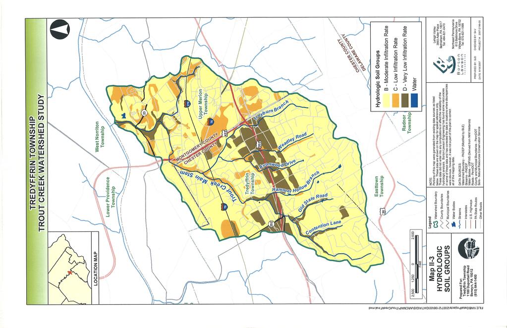
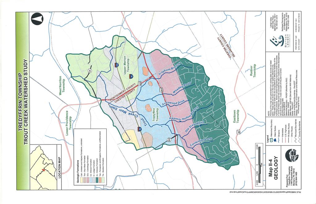
6 of the watershed. The slope of the streambed varies depending upon the location within the watershed. In portions of Tredyffrin Township, particularly in the southwest section of the watershed, the streambed is somewhat steep, whereas along the Main Stem of the Creek, situated to the north of the Turnpike the slope of the stream is relatively flat. D. Soils Soil properties influence the runoff generation process. The USDA, Natural Resources Conservation Service (NRCS) has established a criterion determining how soils will affect runoff by placing all surface horizon soils into four Hydrologic Soil Groups (HSGs) A through D, based on infiltration rate and depth. There are no Group A soils within the Trout Creek watershed. The majority of the surface horizon soils in the watershed, approximately 76%, fall in Group B. Group B is characterized as having moderate infiltration rates and consists of primarily moderately deep to deep and moderately well to well drained soils that exhibit a moderate rate of water transmission. Group C soils, found sporadically throughout the watershed, have slow infiltration rates when thoroughly wetted and contain fragipans, a layer that impedes downward movement of water and produces a slow rate of water transmission. Also found in several areas of the watershed, D soils are tight, low permeable soils with high runoff potential and are typically clay soils. This information was incorporated into the GIS and, from this, the watershed HSG map was developed as shown in Map II-3. E. Geology Geology plays a direct role in surface runoff in the Trout Creek watershed because it creates the various soil types within the watershed through the breakdown of the parent material contained in the rock. The three major geologic formations in the Trout Creek watershed are the Octoraro Formation (approximately 27%), the Stockton Formation (roughly 20%) and the Elbrook Formation (18%). The geologic map of the watershed can be found in Map II-4. As the Chester Valley cuts across Tredyffrin Township a large portion of the Township is underlain by carbonate geology. The carbonate geology is roughly centered along the S.R. 202 corridor with another band stretching northward toward Valley Forge Park and parallel to the north side of the Pennsylvania Turnpike (I-76). In addition to influencing the type of soils within the watershed, carbonate geology has an important role in the hydrology of the watershed, or the way water moves through the watershed. Carbonate rocks typically contain a series of interconnected openings, such as fissures, fractures, and caves which are able to receive and transmit large quantities of stormwater. As the water flows through the openings in the carbonate rock, the water can dissolve the rock making existing fissures and openings larger or creating new openings or interconnections within the rock. Because of this interconnectivity of the carbonate rocks, carbonate geology typically serve as excellent aquifers or sources of ground water supply. Although the carbonate geology serves as a good water resource, if not adequately considered in the design of stormwater management facilities it can create problems as well. Typically stormwater management facilities tend to concentrate stormwater in a single location. If not managed properly this additional stormwater loading or concentration can cause accelerated dissolution of the subsurface geologic formations, creating underground sinkholes in and around stormwater management facilities. Effective stormwater management techniques within carbonate areas II-6
7
8 typically require careful planning to ensure stormwater management facilities are not located in close proximity to existing features that may be susceptible to stormwater damage. A context sensitive stormwater management design is required so as to not overload a single point with excessive stormwater runoff; and installation of various stormwater appurtenances such as impervious liners, bypass channels, and or stormwater distributions systems to disperse flow evenly throughout the site may be required. A description of carbonate and non-carbonate geologic formations modified from Berg, T. M., Geyer, A. R., Edmunds, W. E., and others, compilers, 1980, Geologic map of Pennsylvania, Pennsylvania Geological Survey, 4th ser., Map 1, are provided below. 1. Carbonate (Limestone and Dolomite Bearing) Geologic Formations: CONESTOGA LIMESTONE (OCc) LEDGER DOLOMITE (Cl) - Light-gray, thin-bedded, impure, contorted limestone having shale partings; conglomeratic at base; in Chester Valley, includes micaceous limestone in upperpart, phyllite in middle, and alternating dolomite and limestone in lower part. - Light-gray, locally mottled, massive, pure, coarsely crystalline dolomite; siliceous in middle part. 2. Non-Carbonate Geologic Formations: ANTIETAM AND HARPERS FORMATION, UNDIVIDED (Cah) BRYN MAWR (Tbm) ELBROOK (CE) OCTORARO FORMATION (Xo) PENSAUKEN & BRIDGETON (Tpb) STOCKTON FORMATION (Trs) - The Antietam Formation is a gray, buff-weathering quartzite and quartz schist. Harpers Formation is a dark-greenish-gray phyllite and schist having thin quartzite layers. - High-level terrace deposits; reddish-brown gravelly sand and some silt. Age uncertain. - Light-colored calcareous shale and silty limestone at top; medium-gray limestone and dolomite in middle; pure, dark limestone at base. - Includes albite-chlorite schist, phyllite, some hornblende gneiss, and granitized members. - Dark-reddish-brown, cross-stratified, feldspathic quartz sand and some thin beds of fine gravel and rare layers of clay or silt. - Light-gray to buff, coarse-grained, arkosic sandstone; includes reddish-brown to grayish-purple sandstone, siltstone, and mudstone. II-8
9 F. Land Use All streams and watersheds are dynamic and ever-changing systems; stream channels change based on changes within the watershed, on the surface of the land or changes to the ground water system. Pennsylvania was an area filled with mature woodlands when European settlers arrived in the 1600 s and 1700 s. During those centuries, tremendous changes took place to the landscape as much of Pennsylvania, including the Trout Creek watershed, was cleared of woodlands for agricultural uses. This change, in addition to the use of streams for mills, has a continued impact on the watershed today (Gutshall, 2004). Over the past 60 years, the Trout Creek watershed, like most of eastern Chester County, has transformed from a watershed that was predominantly in woodland and agricultural land uses to a watershed that is a mix of suburban and urban land uses today. However, even as the watershed has developed, a few open spaces remain within the watershed. Map II-5 displays the existing land cover of the watershed while Table II-1 details the land uses by category within the Trout Creek watershed as well as the Tredyffrin Township portion of the watershed. Land Use TABLE II-1 LAND USE STATUS BY CATEGORY Tredyffrin Township Trout Creek Watershed Portion of Trout Creek Watershed (Square Miles) (%) (Square Miles) (%) Agriculture Commercial Forest Industrial Institutional Open Space/ Recreation Paved Residential (1-4 acre lots size) Residential (1/8 acre or less lot size) Open Water < TOTAL The predominant land use in the watershed is classified as residential (46%). Approximately 16% of the watershed is commercial, which is found predominately in the Montgomery County portion of the watershed. Parking facilities account for 14% of the land area within the watershed and is the third highest land use by area. The abundance of parking areas is an indication of the number of office parks, corporate and educational campuses, retail and shopping centers, etc. within the watershed. Open space (parks, cemeteries, golf courses, etc.) accounts for 13% of the area and the II-9
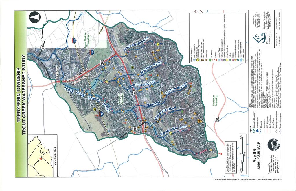
10 remaining 11% of land is classified as either forested, industrial, institutional, water, or agricultural. The Treddyfrin Township section of the watershed has similar percentages of land use as the watershed as a whole. The major differences between the entire watershed and the Tredyffrin section of the watershed are that the Tredyffrin Township portion has slightly less commercial development and paved surfaces and significantly more low density residential development. This is not unexpected as Tredyffrin Township contains the headwaters of the Trout Creek and typically the headwaters of many streams are less developed than areas of the watershed near the mouth. Using the Land Use data for the Trout Creek watershed and Tredyffrin Township and typical impervious cover area by land use from the Environmental Protection Agency an estimate of the total impervious area of the watershed and the Tredyffrin Township section of the watershed can be obtained. As shown in Table II-2, an estimated 41% of the watershed is covered by impervious surface while approximately 35% of the Treddyfrin Township portion of the watershed is covered by impervious surface. Both in the entire watershed and in Tredyffrin Township section of the watershed the biggest contributors of impervious surface are commercial parking and low density residential areas. Although low density residential areas typically only contain about 30 percent impervious surface, these areas can have a significant impact on the stormwater runoff potential within the watershed and especially within the Tredyffrin Township as many of the residential areas were constructed prior to implementation of stormwater management standards and criteria intended to control downstream flooding, streambank erosion, groundwater recharge and water quality. Land Use TABLE II-2 IMPERVIOUS SURFACE BY LAND USE Estimated Percentage of Impervious Cover 1 Trout Creek Watershed (Square Miles) Estimated Impervious (Square Miles) Tredyffrin Township Portion of Trout Creek Watershed (Square Miles) Estimated Impervious (Square Miles) Agriculture Commercial Forest Industrial Institutional Open Space/ Recreation Paved Residential (1-4 acre lots size) Residential (1/8 acre or less lot size) Open Water TOTAL Values compiled from References 7 and 8 G. Analysis Map Map II-6, Analysis Map, was used to assist in locating potential sites for Best Management Practices within the watershed. One of the features included in this map is the location of obstructions. II-10
11 Locations of these significant waterway obstructions were derived from Federal Emergency Management Agency (FEMA) Flood Insurance Study (FIS) flood profiles for Trout Creek. Significant obstructions were noted on the flood profiles as those locations were the water surface elevation upstream of a culvert or bridge were substantially higher than the water surface elevation downstream of a culvert or bridge. Locations of erosion and channel alterations were obtained from the Trout Creek Watershed Restoration and Protection Plan (The Ratsep Group, June 2004). There are many existing stormwater detention basin facilities and one proposed facility in the vicinity of the PA Turnpike s service plaza shown on this map. These facility locations were obtained from Tredyffrin Township. Other areas of interest that were mapped to help locate prospective BMP sites include areas prone to flooding, schools, roadwork plans, service plazas, and large shopping centers. II-11

12
13
Section 4: Model Development and Application
 Section 4: Model Development and Application The hydrologic model for the Wissahickon Act 167 study was built using GIS layers of land use, hydrologic soil groups, terrain and orthophotography. Within
PENNSYLVANIA DEPARTMENT OF TRANSPORTATION ENGINEERING DISTRICT 3-0
 PENNSYLVANIA DEPARTMENT OF TRANSPORTATION ENGINEERING DISTRICT 3-0 LYCOMING COUNTY S.R.15, SECTION C41 FINAL HYDROLOGIC AND HYDRAULIC REPORT STEAM VALLEY RUN STREAM RELOCATION DATE: June, 2006 REVISED:
 12 10 8 6 4 2 0 40-50 50-60 60-70 70-80 80-90 90-100 Fresh Water What we will cover The Hydrologic Cycle River systems Floods Groundwater Caves and Karst Topography Hot springs Distribution of water in
3.11 Floodplains Existing Conditions
 Other stormwater control practices may be needed to mitigate water quality impacts. In addition to detention facilities, other practices such as vegetated basins/buffers, infiltration basins, and bioswales
Hydrogeological Assessment for Part of Lots 2 and 3, Concession 5, Township of Thurlow, County of Hastings 1.0 INTRODUCTION. 1.
 February 10,2017 25506400 Ontario Ltd. Foxboro, ON Attention: Brad Newbatt Re: Hydrogeological Assessment for Part of Lots 2 and 3, Concession 5, Township of Thurlow, County of Hastings 1.0 INTRODUCTION
Darby Creek Watershed Conservation Plan
 Section III Earth Resources III - 1 III. EARTH RESOURCES A. Geology Geologic Overview: Age and History The upper portions (headwaters) of the Darby Creek Watershed are comprised primarily of older rock
The last three sections of the main body of this report consist of:
 Threatened and Endangered Species Geological Hazards Floodplains Cultural Resources Hazardous Materials A Cost Analysis section that provides comparative conceptual-level costs follows the Environmental
How Do Geology and Physical Streambed Characteristics Affect Water Quality?
 Teacher s Guide How Do Geology and Physical Streambed Characteristics Affect Water Quality? Lesson Description In this lesson, the students research a dynamic, vertical dimension of a watershed - the geological
Appendix D. Sediment Texture and Other Soil Data
 5 6 7 8 Appendix D. Sediment Texture and Other Soil Data This appendix describes the sediment texture of the aquifer system in the Restoration Area. The contents of this appendix describe the: Importance
Erosion Surface Water. moving, transporting, and depositing sediment.
 + Erosion Surface Water moving, transporting, and depositing sediment. + Surface Water 2 Water from rainfall can hit Earth s surface and do a number of things: Slowly soak into the ground: Infiltration
URBAN HYDROLOGY: WATER IN THE CITY OF TSHWANE Plant Sciences Auditorium, University of Pretoria January 2014 URBAN HYDROGEOLOGY
 URBAN HYDROLOGY: WATER IN THE CITY OF TSHWANE Plant Sciences Auditorium, University of Pretoria 23 24 January 2014 URBAN HYDROGEOLOGY MATTHYS A. DIPPENAAR DEPARTMENT GEOLOGY, UNIVERSITY OF PRETORIA HYDROGEOLOGY
Stream Geomorphology. Leslie A. Morrissey UVM July 25, 2012
 Stream Geomorphology Leslie A. Morrissey UVM July 25, 2012 What Functions do Healthy Streams Provide? Flood mitigation Water supply Water quality Sediment storage and transport Habitat Recreation Transportation
Big Rivers Electric Corporation Disposal of Coal Combustion Residuals (CCR) from Electric Utilities Final Rule CCR Impoundment Liner Assessment Report
 from Electric Utilities Final Rule CCR Impoundment Liner Assessment Report") Big Rivers Electric Corporation Disposal of Coal Combustion Residuals (CCR) from Electric Utilities Final Rule CCR Impoundment Liner Assessment Report CCR Surface Impoundment Information Name: Operator:
Big Rivers Electric Corporation Disposal of Coal Combustion Residuals (CCR) from Electric Utilities Final Rule CCR Impoundment Liner Assessment Report CCR Surface Impoundment Information Name: Operator:
Vermont Stream Geomorphic Assessment. Appendix E. River Corridor Delineation Process. VT Agency of Natural Resources. April, E0 - April, 2004
 Vermont Stream Geomorphic Assessment Appendix E River Corridor Delineation Process Vermont Agency of Natural Resources - E0 - River Corridor Delineation Process Purpose A stream and river corridor delineation
HISTORY OF CONSTRUCTION FOR EXISTING CCR SURFACE IMPOUNDMENT PLANT GASTON ASH POND 40 CFR (c)(1)(i) (xii)
(1)(i) (xii)") HISTORY OF CONSTRUCTION FOR EXISTING CCR SURFACE IMPOUNDMENT PLANT GASTON ASH POND 40 CFR 257.73(c)(1)(i) (xii) (i) Site Name and Ownership Information: Site Name: E.C. Gaston Steam Plant Site Location:
HISTORY OF CONSTRUCTION FOR EXISTING CCR SURFACE IMPOUNDMENT PLANT GASTON ASH POND 40 CFR 257.73(c)(1)(i) (xii) (i) Site Name and Ownership Information: Site Name: E.C. Gaston Steam Plant Site Location:
How & Where does infiltration work? Summary of Geologic History Constraints/benefits for different geologic units
 June 26, 2007: Low Impact Development 1 Associated Earth Sciences, Inc. Associated Earth Sciences, Inc. Presented by: Matthew A. Miller, PE April 24, 2012 How & Where does infiltration work? Summary of
KRIS wsbssm. IBHiiilll
 KRIS wsbssm IBHiiilll Digitized by the Internet Archive in 2012 with funding from University of Illinois Urbana-Champaign http://archive.org/details/engineeringaspec34ekbl STATE OF ILLINOIS HENRY HORNER,
Watershed concepts for community environmental planning
 Purpose and Objectives Watershed concepts for community environmental planning Dale Bruns, Wilkes University USDA Rural GIS Consortium May 2007 Provide background on basic concepts in watershed, stream,
HYDROLOGIC AND HYDRAULIC REPORT FOR SR. 0522, SECTION 5BN ALONG BLACKLOG CREEK CROMWELL TOWNSHIP HUNTINGDON COUNTY. Prepared for:
 HYDROLOGIC AND HYDRAULIC REPORT FOR SR. 0522, SECTION 5BN ALONG BLACKLOG CREEK CROMWELL TOWNSHIP Prepared for: KCI Technologies, Inc. Mechanicsburg, PA and Pennsylvania Department of Transportation Engineering
Chapter 3 Erosion in the Las Vegas Wash
 Chapter 3 Erosion in the Las Vegas Wash Introduction As described in Chapter 1, the Las Vegas Wash (Wash) has experienced considerable change as a result of development of the Las Vegas Valley (Valley).
J.H. Campbell Generating Facility Pond A - Location Restriction Certification Report
 J.H. Campbell Generating Facility Pond A - Location Restriction Certification Report Pursuant to: 40 CFR 257.60 40 CFR 257.61 40 CFR 257.62 40 CFR 257.63 40 CFR 257.64 Submitted to: Consumers Energy Company
KANSAS GEOLOGICAL SURVEY Open File Report LAND SUBSIDENCE KIOWA COUNTY, KANSAS. May 2, 2007
 KANSAS GEOLOGICAL SURVEY Open File Report 2007-22 LAND SUBSIDENCE KIOWA COUNTY, KANSAS Prepared by Michael T. Dealy L.G., Manager, Wichita Operations SITE LOCATION The site was approximately four miles
Laboratory Exercise #3 The Hydrologic Cycle and Running Water Processes
 Laboratory Exercise #3 The Hydrologic Cycle and Running Water Processes page - 1 Section A - The Hydrologic Cycle Figure 1 illustrates the hydrologic cycle which quantifies how water is cycled throughout
3.18 GEOLOGY AND SOILS
 3.18 GEOLOGY AND SOILS This section discusses geologic resource concerns as they relate to the environment, public safety, and project design both during construction and after completion of the project.
Chapter 2. Regional Landscapes and the Hydrologic Cycle
 Chapter 2. Regional Landscapes and the Hydrologic Cycle W. Lee Daniels Department of Crop and Soil Environmental Sciences, Virginia Tech Table of Contents Introduction... 23 Soils and landscapes of the
720 Land Conditions Comprehensive Plan Section 720
 721 720 omprehensive Plan Section 720 REGIONAL SETTING Owensboro is located on the Ohio River, in the western part of the state of Kentucky. According to Housing Market Analysis, Owensboro s regional relationship
Wisconsin s Hydrogeology: an overview
 2012 Soil and Water Conservation Society Conference Stevens Point, WI Feb 9, 2012 Wisconsin s Hydrogeology: an overview Ken Bradbury Wisconsin Geological and Natural History Survey University of Wisconsin-Extension
What we will cover. The Hydrologic Cycle. River systems. Floods. Groundwater. Caves and Karst Topography. Hot springs
 Fresh Water What we will cover The Hydrologic Cycle River systems Floods Groundwater Caves and Karst Topography Hot springs On a piece of paper, put these reservoirs of water in to order from largest to
For Sale - 56 Acre Sandstone Quarry State Route 511, Oberlin/Kipton, OH 44075
 14647 State Route 511, Oberlin/Kipton, OH 44075 56 ACRES Vermilion Rd Gifford Rd Haigh Rd 44 Summary The Kipton sandstone quarry is included in 56 acre tract owned by Terry A. Johnson, of Huron, Ohio.
Surface Processes Focus on Mass Wasting (Chapter 10)
") Surface Processes Focus on Mass Wasting (Chapter 10) 1. What is the distinction between weathering, mass wasting, and erosion? 2. What is the controlling force in mass wasting? What force provides resistance?
Surface Processes Focus on Mass Wasting (Chapter 10) 1. What is the distinction between weathering, mass wasting, and erosion? 2. What is the controlling force in mass wasting? What force provides resistance?
Custom Soil Resource Report for Forrest County, Mississippi
 United States Department of Agriculture Natural Resources Conservation Service A product of the National Cooperative Soil Survey, a joint effort of the United States Department of Agriculture and other
3/3/2013. The hydro cycle water returns from the sea. All "toilet to tap." Introduction to Environmental Geology, 5e
 Introduction to Environmental Geology, 5e Running Water: summary in haiku form Edward A. Keller Chapter 9 Rivers and Flooding Lecture Presentation prepared by X. Mara Chen, Salisbury University The hydro
6.1 Water. The Water Cycle
 6.1 Water The Water Cycle Water constantly moves among the oceans, the atmosphere, the solid Earth, and the biosphere. This unending circulation of Earth s water supply is the water cycle. The Water Cycle
Procedure for Determining Near-Surface Pollution Sensitivity
 Procedure for Determining Near-Surface Pollution Sensitivity Minnesota Department of Natural Resources Division of Ecological and Water Resources County Geologic Atlas Program March 2014 Version 2.1 I.
Summary Description Municipality of Anchorage. Anchorage Coastal Resource Atlas Project
 Summary Description Municipality of Anchorage Anchorage Coastal Resource Atlas Project By: Thede Tobish, MOA Planner; and Charlie Barnwell, MOA GIS Manager Introduction Local governments often struggle
Prentice Hall EARTH SCIENCE
 Prentice Hall EARTH SCIENCE Tarbuck Lutgens Running Water and Groundwater Running Water The Water Cycle Water constantly moves among the oceans, the atmosphere, the solid Earth, and the biosphere. This
There are many different kinds of salt, but for simplicity sake, sodium chloride (NaCl) in particular will be the topic of discussion.
 in particular will be the topic of discussion.") There are many different kinds of salt, but for simplicity sake, sodium chloride (NaCl) in particular will be the topic of discussion. NaCl comes from both natural and anthropogenic sources. Naturally
There are many different kinds of salt, but for simplicity sake, sodium chloride (NaCl) in particular will be the topic of discussion. NaCl comes from both natural and anthropogenic sources. Naturally
Proposed Cemetery Thornhill Road. Tier One Hydrogeological Risk Assessment. Peter Mitchell Associates
 Proposed Cemetery Thornhill Road Tier One Hydrogeological Risk Assessment Peter Mitchell Associates January 2015 Executive Summary This report uses a desk-based risk assessment technique published by the
CAUSES FOR CHANGE IN STREAM-CHANNEL MORPHOLOGY
 CAUSES FOR CHANGE IN STREAM-CHANNEL MORPHOLOGY Chad A. Whaley, Department of Earth Sciences, University of South Alabama, MobileAL, 36688. E-MAIL: caw408@jaguar1.usouthal.edu The ultimate goal of this
CASE STUDY #9 - Brushy Fork Dam, Sugar Grove, West Virginia
 CASE STUDY #9 - Brushy Fork Dam, Sugar Grove, West Virginia Brushy Fork Dam is a flood control structure built by the Soil Conservation Service southeast of the city of Franklin in Pendleton County, West
Which map shows the stream drainage pattern that most likely formed on the surface of this volcano? A) B)
 B)") 1. When snow cover on the land melts, the water will most likely become surface runoff if the land surface is A) frozen B) porous C) grass covered D) unconsolidated gravel Base your answers to questions
1. When snow cover on the land melts, the water will most likely become surface runoff if the land surface is A) frozen B) porous C) grass covered D) unconsolidated gravel Base your answers to questions
Critical Aquifer Recharge Area Susceptibility Index Methodology
 Prepared for 207 4th Ave. N. Kelso, WA 98626 Prepared by Parametrix 700 NE Multnomah, Suite 1000 Portland, OR 97232-4110 T. 503.233.2400 T. 360.694.5020 F. 1.855.542.6353 www.parametrix.com July 5, 2016
Starting at Rock Bottom
 Starting at Rock Bottom At rock bottom of the Brushy Creek site s geological column lies the first clue to human habitation: A smelting and heattreating furnace, and mold, carved into Bed Ked: Figure 15
SL GEOLOGY AND MINING. Coal bearing strata in the project area are referable primarily to the Allegheny Group of
 SL-145-1 GEOLOGY AND MINING Coal bearing strata in the project area are referable primarily to the Allegheny Group of Pennsylvania age. These rocks occur as dissected remnants overlying the ridge-forming
STUDY GUIDE FOR CONTENT MASTERY. Surface Water Movement
 Surface Water SECTION 9.1 Surface Water Movement In your textbook, read about surface water and the way in which it moves sediment. Complete each statement. 1. An excessive amount of water flowing downslope
This material is part of the collection of the Philadelphia Water Department and was downloaded from the website Please contact the
 This material is part of the collection of the Philadelphia Water Department and was downloaded from the website www.phillyh2o.org Please contact the PhillyH2O webmaster for more information about this
ROAD SEDIMENT ASSESSMENT & MODELING: KOOTENAI-FISHER TMDL PLANNING AREA ROAD GIS LAYERS & SUMMARY STATISTICS
 ROAD SEDIMENT ASSESSMENT & MODELING: KOOTENAI-FISHER TMDL PLANNING AREA ROAD GIS LAYERS & SUMMARY STATISTICS Prepared by: ATKINS Water Resources Group 820 North Montana Avenue Helena, MT 59601 November
Diagnostic Geomorphic Methods for Understanding Future Behavior of Lake Superior Streams What Have We Learned in Two Decades?
 Diagnostic Geomorphic Methods for Understanding Future Behavior of Lake Superior Streams What Have We Learned in Two Decades? Faith Fitzpatrick USGS WI Water Science Center, Middleton, WI fafitzpa@usgs.gov
Surface Water and Stream Development
 Surface Water and Stream Development Surface Water The moment a raindrop falls to earth it begins its return to the sea. Once water reaches Earth s surface it may evaporate back into the atmosphere, soak
Soils, Hydrogeology, and Aquifer Properties. Philip B. Bedient 2006 Rice University
 Soils, Hydrogeology, and Aquifer Properties Philip B. Bedient 2006 Rice University Charbeneau, 2000. Basin Hydrologic Cycle Global Water Supply Distribution 3% of earth s water is fresh - 97% oceans 1%
IV. ENVIRONMENTAL IMPACT ANALYSIS G. GEOLOGY AND SOILS
 IV. ENVIRONMENTAL IMPACT ANALYSIS G. GEOLOGY AND SOILS The following section is based upon the City of El Segundo General Plan and General Plan EIR and addresses the following geologic issues: soil erosion,
3.12 Geology and Topography Affected Environment
 3 Affected Environment and Environmental Consequences 3.12 Geology and Topography 3.12.1 Affected Environment 3.12.1.1 Earthquakes Sterling Highway MP 45 60 Project Draft SEIS The Kenai Peninsula is predisposed
Soil Map Boulder County Area, Colorado (Planet Blue Grass) Web Soil Survey National Cooperative Soil Survey
 Web Soil Survey National Cooperative Soil Survey") 475910 476000 476090 476180 476270 476360 105 16' 21'' W 476450 476540 476630 476720 476810 4453350 4453440 4453260 4453350 4453170 4453260 4453080 4453170 4453080 475820 475910 4452990 476000 476090 476180
475910 476000 476090 476180 476270 476360 105 16' 21'' W 476450 476540 476630 476720 476810 4453350 4453440 4453260 4453350 4453170 4453260 4453080 4453170 4453080 475820 475910 4452990 476000 476090 476180
Why Geomorphology for Fish Passage
 Channel Morphology - Stream Crossing Interactions An Overview Michael Love Michael Love & Associates mlove@h2odesigns.com (707) 476-8938 Why Geomorphology for Fish Passage 1. Understand the Scale of the
Name: Mid-Year Review #2 SAR
 Name: Mid-Year Review #2 SAR Base your answers to questions 1 through 3 on on the diagram below, which shows laboratory materials used for an investigation of the effects of sediment size on permeability,
Pennypack Creek Watershed Act 167 Study
 Pennypack Creek Watershed Act 167 Study Progress Report December 17, 2009 Jeffrey Featherstone jeffrey.featherstone@temple.edu Mahbubur Meenar meenar@temple.edu Rick Fromuth richard.fromuth@temple.edu
WATER ON AND UNDER GROUND. Objectives. The Hydrologic Cycle
 WATER ON AND UNDER GROUND Objectives Define and describe the hydrologic cycle. Identify the basic characteristics of streams. Define drainage basin. Describe how floods occur and what factors may make
Section I: Multiple Choice Select the best answer to each question. Mark your final answer on the answer sheet. (1 pt each)
") Sedimentary Rocks & Surface Processes Quest Name: Earth Science 2013 Block: Date: Section I: Multiple Choice Select the best answer to each question. Mark your final answer on the answer sheet. (1 pt each)
Sedimentary Rocks & Surface Processes Quest Name: Earth Science 2013 Block: Date: Section I: Multiple Choice Select the best answer to each question. Mark your final answer on the answer sheet. (1 pt each)
HW #2 Landscape Travel from A to B 12,
 HW #2 Landscape 2016 Section: Name: ate: 1. ase your answer(s) to the following question(s) on the map below, which represents two bridges that cross the Green River. Letters,, and represent locations
Florida s Karst Geology
 Florida s Karst Geology Orange Creek Basin Interagency Working Group Public Workshop, November 5 th, 2015 Harley Means, P.G. Assistant State Geologist Florida Geological Survey Karst Karst a type of topography
WISSAHICKON CREEK DRAINAGE BASIN ORIGIN AS DETERMINED BY TOPOGRAPHIC MAP INTERPRETATION INTRODUCTION
 Middle States Geographer, 2016, 49: 33-42 WISSAHICKON CREEK DRAINAGE BASIN ORIGIN AS DETERMINED BY TOPOGRAPHIC MAP INTERPRETATION Eric Clausen 100 West Ave D-17 Jenkintown, PA 19046 ABSTRACT: Topographic
APPENDIX 3B OCCURRENCE OF SIGNIFICANT RIVER ALLUVIUM AQUIFERS IN THE PLATEAU REGION
 Plateau Region Water Plan January 2011 APPENDIX 3B OCCURRENCE OF SIGNIFICANT RIVER ALLUVIUM AQUIFERS IN THE PLATEAU REGION Occurrence of Significant River Alluvium Aquifers in the Plateau Region Prepared
Ecoregions Glossary. 7.8B: Changes To Texas Land Earth and Space
 Ecoregions Glossary Ecoregions The term ecoregions was developed by combining the terms ecology and region. Ecology is the study of the interrelationship of organisms and their environments. The term,
Summary. Streams and Drainage Systems
 Streams and Drainage Systems Summary Streams are part of the hydrologic cycle and the chief means by which water returns from the land to the sea. They help shape the Earth s surface and transport sediment
Gully Erosion Part 1 GULLY EROSION AND ITS CAUSES. Introduction. The mechanics of gully erosion
 Gully Erosion Part 1 GULLY EROSION AND ITS CAUSES Gully erosion A complex of processes whereby the removal of soil is characterised by incised channels in the landscape. NSW Soil Conservation Service,
Lecture Outlines PowerPoint. Chapter 5 Earth Science 11e Tarbuck/Lutgens
 Lecture Outlines PowerPoint Chapter 5 Earth Science 11e Tarbuck/Lutgens 2006 Pearson Prentice Hall This work is protected by United States copyright laws and is provided solely for the use of instructors
Working with Natural Stream Systems
 Working with Natural Stream Systems Graydon Dutcher Delaware County Soil & Water Conservation District Stream Corridor Management Program Tropical Storm Sandy October 29,2012 What is a Watershed?
Betsy Stevenson and Allison Mohrs (Skagit County Planning and Development Services) Jenny Baker, The Nature Conservancy
 Jenny Baker, The Nature Conservancy") TC Fisher Slough Final Design and Permitting Subject: Well Review Memorandum To: From: Betsy Stevenson and Allison Mohrs (Skagit County Planning and Development Services) Jenny Baker, The ature Conservancy
TC Fisher Slough Final Design and Permitting Subject: Well Review Memorandum To: From: Betsy Stevenson and Allison Mohrs (Skagit County Planning and Development Services) Jenny Baker, The ature Conservancy
Black Gore Creek 2013 Sediment Source Monitoring and TMDL Sediment Budget
 Black Gore Creek 2013 Sediment Source Monitoring and TMDL Sediment Budget Prepared for: Prepared By: - I. Introduction The Black Gore Creek Total Maximum Daily Load (TMDL) was developed in collaboration
Stream Simulation: A Simple Example
 Stream Simulation: A Simple Example North Thompson Creek, CO Paul T. Anderson U.S.D.A. Forest Service Here s How We Started May 2011 2-1 USDA-Forest Service Here s How We Finished Forest Service Aquatic
Geotechnical Aspects of the Ohio River Bridges Project
 Geotechnical Aspects of the Ohio River Bridges Project Mark A. Litkenhus, PE Sr. Geotechnical Engineer Stephen H. Bickel, PE Sr. Geotechnical Engineer STGEC Ohio River Bridges at Louisville Geotechnical
THE STRUCTURE AND THICKNESS OF THE CLINTON AND BEREA FORMATIONS IN THE VICINITY OF WOOSTER, OHIO
 THE STRUCTURE AND THICKNESS OF THE CLINTON AND BEREA FORMATIONS IN THE VICINITY OF WOOSTER, OHIO KARL VER STEEG College of Wooster INTRODUCTION AND ACKNOWLEDGMENTS The data used in the construction of
LOCATED IN INDIAN RIVER COUNTY PREPARED FOR S.J.R.W.M.D. AND F.W.C.D. DECEMBER, 2003 Updated 2007 Updated May 2014 PREPARED BY
 FELLSMERE WATER CONTROL DISTRICT EAST MASTER DRAINAGE PLAN AND STORMWATER HYDROLOGIC ANALYSIS OF THE GRAVITY DRAINAGE SYSTEM LOCATED BETWEEN THE EAST BOUNDARY, LATERAL U, THE MAIN CANAL, AND DITCH 24 LOCATED
Floodplain modeling. Ovidius University of Constanta (P4) Romania & Technological Educational Institute of Serres, Greece
 Romania & Technological Educational Institute of Serres, Greece") Floodplain modeling Ovidius University of Constanta (P4) Romania & Technological Educational Institute of Serres, Greece Scientific Staff: Dr Carmen Maftei, Professor, Civil Engineering Dept. Dr Konstantinos
Floodplain modeling Ovidius University of Constanta (P4) Romania & Technological Educational Institute of Serres, Greece Scientific Staff: Dr Carmen Maftei, Professor, Civil Engineering Dept. Dr Konstantinos
Observations on Surface Water in the Seminary Fen in Spring, Prepared 6/4/13 by Sam Wetterlin; updated 7/28/13
 Observations on Surface Water in the Seminary Fen in Spring, 2013 Prepared 6/4/13 by Sam Wetterlin; updated 7/28/13 Ordinarily, a calcareous fen is primarily dependent on upwelling mineral-rich, oxygen-poor
=%REPORT RECONNAISSANCE OF CHISHOLM LAKE PROSPECT. October 25, 1977
 =%REPORT ON FIELD RECONNAISSANCE OF CHISHOLM LAKE PROSPECT October 25, 1977 Bruce D. Vincent Imperial Oil Limited, Minerals - Coal, CALGARY, ALBERTA CHISHOLM LAKE PROSPECT Introduction The Chisholm Lake
STORMWATER MANAGEMENT COMPUTATIONS. Mount Prospect
 STORMWATER MANAGEMENT COMPUTATIONS Mount Prospect MHG PROJECT No. 2011.173.11 November 6, 2014 Prepared for: Piney Meetinghouse Investments c/o Mr. Dennis Fling 14801 Clopper Road Boyds, MD 20841 (301)
QUANTITY, MARCH 1962
 BASE-FLOW STUDIES, GUADALUPE RIVER COMAL COUNTY, TEXAS QUANTITY, MARCH 1962 TEXAS WATER COMMISSION BULLETIN 6503 MARCH 1965 TEXAS WATER COMMISSION Joe William D E 0. F. Dent Carter, Chairman Berger, Commissioner
Directed Reading. Section: Types of Maps
 Skills Worksheet Directed Reading Section: Types of Maps 1. What are some of the characteristics of an area shown on maps used by Earth scientists? a. types of animals, types of plants, types of minerals
Cretaceous, Dakota Formation, Terra Cotta Member South Side of I-70, Salina County, Kansas
 Cretaceous, Dakota Formation, Terra Cotta Member South Side of I-70, Salina County, Kansas Written By: Steven D.J. Baumann G-102010-1A Outcrop looking southeast Photo taken by: Steven Baumann on 10-20-2010
Geology and Soils. Technical Memorandum
 Geology and Soils Technical Memorandum TO: FDOT FROM: HDR, Inc. DATE: February 2013 PROJECT: St Johns River Crossing FPID No: 208225-3-21-01 Clay, Duval, and St. Johns Counties; Florida Geology and soils
Opportunities to Improve Ecological Functions of Floodplains and Reduce Flood Risk along Major Rivers in the Puget Sound Basin
 Opportunities to Improve Ecological Functions of Floodplains and Reduce Flood Risk along Major Rivers in the Puget Sound Basin Christopher Konrad, US Geological Survey Tim Beechie, NOAA Fisheries Managing
Connecticut's Aquifers
 Page 1 of 5 DEP Search: Connecticut's Aquifers The technical definition of the word "aquifer" is: any geologic formation capable of yielding significant quantities of water to wells. By that definition,
Soil Map Polk County, Florida
 Soil Map Polk County, Florida 28 9' 21'' 28 8' 23'' 3113000 3113200 3113400 3113600 3113800 3114000 3114200 3114400 3114600 81 51' 19'' 81 51' 19'' 416000 416000 ± 416200 416200 68 416400 68 416400 7 13
Pennypack Creek Drainage Basin Erosion History: Bucks, Montgomery, and Philadelphia Counties, PA, USA
 Journal of Geography and Geology; Vol. 9, No. 1; 2017 ISSN 1916-9779 E-ISSN 1916-9787 Published by Canadian Center of Science and Education Pennypack Creek Drainage Basin Erosion History: Bucks, Montgomery,
SECTION G SEDIMENT BUDGET
 SECTION G SEDIMENT BUDGET INTRODUCTION A sediment budget has been constructed for the for the time period 1952-2000. The purpose of the sediment budget is to determine the relative importance of different
Chapter 2: Description of Planning Area
 2020 Facilities Plan Facilities Plan Report Chapter 2: Description of Planning Area 2.1 Introduction This chapter describes Milwaukee Metropolitan Sewerage District s (MMSD) planning area and existing
Impact : Changes to Existing Topography (Less than Significant)
") 4.2 Land Resources 4.2.1 Alternative A Proposed Action Impact 4.2.1-1: Changes to Existing Topography (Less than Significant) Development of the project site would involve grading and other earthwork as
4.2 Land Resources 4.2.1 Alternative A Proposed Action Impact 4.2.1-1: Changes to Existing Topography (Less than Significant) Development of the project site would involve grading and other earthwork as
Natural and Human Influences on Flood Zones in Wake County. Georgia Ditmore
 Natural and Human Influences on Flood Zones in Wake County Georgia Ditmore Prepared for GEOG 591 December 5, 2014 2 Table of Contents Introduction.3 Objectives...5 Methods...6 Conclusion.11 References
Watershed Analysis Using Remote Sensing and GPS
 25 th Annual Louisiana Remote Sensing and GIS Workshop Baton Rouge, 2009 Watershed Analysis Using Remote Sensing and GPS Warren L. Kron, Jr. Quang Tran Baton Rouge City-Parish Planning Commission José
Exhibit RMP-4. Foote Creek Geology and Topography
 Exhibit RMP-4 Foote Creek Geology and Topography Memorandum To: From: CC: Travis Brown, PacifiCorp Daria Drago, P.E., PMP Dr. Deb Luchsinger Date: January 9, 2019 Re: Foote Creek Rim 1 - Geologic Conditions
TSEGI WASH 50% DESIGN REPORT
 TSEGI WASH 50% DESIGN REPORT 2/28/2014 Daniel Larson, Leticia Delgado, Jessica Carnes I Table of Contents Acknowledgements... IV 1.0 Project Description... 1 1.1 Purpose... 1 Figure 1. Erosion of a Headcut...
Appendix C Fluvial Flood Hazards
 Appendix C Fluvial Flood Hazards Sea Level Rise Vulnerability Assessment and Adaptation Project March 2019 Contents Contents... i Figures... i Tables... i Definitions, Acronyms, & Abbreviations... ii
ENGINEER S CERTIFICATION OF FAULT AREA DEMONSTRATION (40 CFR )
") PLATTE RIVER POWER AUTHORITY RAWHIDE ENERGY STATION BOTTOM ASH TRANSFER (BAT) IMPOUNDMENTS LARIMER COUNTY, CO ENGINEER S CERTIFICATION OF FAULT AREA DEMONSTRATION (40 CFR 257.62) FOR COAL COMBUSTION RESIDUALS
PLATTE RIVER POWER AUTHORITY RAWHIDE ENERGY STATION BOTTOM ASH TRANSFER (BAT) IMPOUNDMENTS LARIMER COUNTY, CO ENGINEER S CERTIFICATION OF FAULT AREA DEMONSTRATION (40 CFR 257.62) FOR COAL COMBUSTION RESIDUALS
Hydrogeology of Karst NE Wisconsin. Dr. Maureen A. Muldoon UW-Oshkosh Geology Department
 Hydrogeology of Karst NE Wisconsin Dr. Maureen A. Muldoon UW-Oshkosh Geology Department WI Bedrock Outline Karst Landscapes Existing WQ Data Flow in Karst Aquifers Overview of Silurian Aquifer Water Level
Aquifer an underground zone or layer of sand, gravel, or porous rock that is saturated with water.
 Aggradation raising of the streambed by deposition that occurs when the energy of the water flowing through a stream reach is insufficient to transport sediment conveyed from upstream. Alluvium a general
PARADIGM ODP FORT COLLINS, CO 80525
 DRAINAGE REPORT PARADIGM ODP FORT COLLINS, CO 80525 Prepared For: Paradigm Properties, LLC 2186 Knoll Drive Ventura, CA 93003 Prepared By Coffey Engineering & Surveying 4045 St. Cloud Drive, Suite 180
Huron Creek Watershed 2005 Land Use Map
 Huron Creek Watershed 2005 Land Use Map Created By: Linda Kersten, 12/20/06 Created For: MTU Introduction to GIS Class (FW 5550) The Huron Creek Watershed Advisory Committee Michigan Technological University,
YELLOWSTONE RIVER FLOOD STUDY REPORT TEXT
 YELLOWSTONE RIVER FLOOD STUDY REPORT TEXT TECHNICAL REPORT Prepared for: City of Livingston 411 East Callender Livingston, MT 59047 Prepared by: Clear Creek Hydrology, Inc. 1627 West Main Street, #294
One Hilltop, Three Major Watersheds!
 One Hilltop, Three Major Watersheds! Adapted from: An original Creek Connections activity. Creek Connections, Box E, Allegheny College, Meadville, Pennsylvania, 16335 Watersheds of PA/ Topo Map Review