SOTMAS Geophysical Survey of Norbury Moated Manor house
|
|
|
- Lewis Stanley
- 5 years ago
- Views:
Transcription

1 SOTMAS Geophysical Survey of Norbury Moated Manor house Illustration from Dr. Plot by Burghers of Norbury Manor as it was in The gargoyle recovered from the moat. Introduction Ralph de Botiller succeeded to the fortified manor house of Norbury on the death of Philip Marmion in The moated house of Norbury Manor was built by Ralph de Botiller in the early fourteenth century (John Darlington, in Stafford Past suggests between 1291 and 1307). In 1521 Norbury Manor was sold to a lawyer, Thomas Skrymsher. The Skrymsher family appear to have owned the property for the next 250 years. Certainly in 1686 Dr. Plot illustrates the house with Sir Charles Skymsher and his wife standing outside. To quote John Darlington s description of the illustration It shows a gateway in the middle of the
2 platform, which was reached by crossing a bridge. The building formed a vertical continuation of the moat revetment walls and the lower floor is part of the original hall dating to c The upper two levels of mullioned and transomed windows with gables above and the jettied gallery are likely to have been 16 th century. On the corner of the building the illustration shows a bartizan a small projecting turret which also dates to the 16 th century. The building has considerable similarities with the fortified manor house of Stokesay (built in 1291) in south Shropshire. In addition the illustration appears to show a gargoyle high up on the left, just below the roof. A similar stone head was recovered from the moat within living memory, in a position immediately below the point illustrated. The Skrymsher family also lived at Aqualate Hall. Sir Thomas Skymsher was Lord of the manor of Mere and built the first hall at Aqualate. He died in The house and estate at Norbury became the property of George Anson of Shugborough Hall, Staffordshire in By the early nineteenth century the building was in a dilapidated state and lived in by farm workers. The building was demolished in 1838 and a new house was built further to the south, using stone from the old manor house. In 1975 English Heritage instituted a watching brief. The geological deposits of the immediate area are classified as "Till, Devensian - Diamicton" i.e. boulder clay or other unstratified sediment deposited by melting glaciers or ice sheets dating to the period between 120,000 and 10,000 years ago. The Devensian is interpreted as the last full glacial series within the Pleistocene. The term Diamiction relates to poorly sorted sediment that contains a wide range of particle sizes i.e. sand or larger size particles that are suspended in a mud matrix. The underlying bedrock is from the Mercia Mudstone Group (Mudstone and Halite- Stone: sedimentary bedrock formed approximately 206 to 248 million years ago in the Triassic Period. The local environment was previously dominated by hot deserts). The moat is fed from the west and outflows eastwards into the Wood Brook. This brook gradually turns south and then south west to pass under the canal just south of Norbury Junction. Close to the moat, to the north and west, are a series of fish ponds. These lie within a small wooded area. South, east and north revetment walls of the moat, with wood to the west.

; (30, 50) was 14.62 metres from the outside of the northmost gate post, and 15.")
3 Methods Map of the Moated site and the immediate area with resistivity results superimposed. It was thought that a geophysical survey of the moat platform may indicate the location of the walls of the demolished buildings. To set up a grid for the operation it was noted that the north west corner of the platform was almost due west of the entrance gate. This was to be treated as the 50 metre north line of the grid. The following points were located: The north west corner would be at (-10.20, 50); (30, 50) was metres from the outside of the northmost gate post, and metres from the outside of the southmost gate post; (45,30) was 1.24 metres from the outside of the northmost gate post, and 2.41 metres from the outside of the southmost gate post. From these points the grid was set out. The platform surface was strewn with large slabs of dressed sandstone. In particular there was a large pile of these in a central position. Other concentrations were found near the
4 edges of the platform. This created a problem for both magnetometry and resistivity, meaning that certain areas could not be surveyed. Grid layout using the north west corner and gate posts as fixed points.
 and rear.")
.")
5 Resistivity results. An area 44 metres east to west and 51 metres north to south was surveyed. The resistivity results are very interesting. There is a clear distinction between the material at the centre of the platform and that from the front (north east facing side of the platform) and rear. This could indicate that the footprints of the buildings still exist. This certainly seems to be the case near the entrance where there may be indications of linear features (robbed wall bases). Alternatively it could reflect the earth works performed to raise the platform, to produce a flat raised area before the buildings were erected.


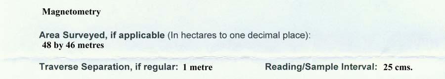
6 Magnetometry results. An area 48 metres east to west and 46 metres north to south was surveyed. The magnetometry results probably have no indication of any structures on the site. There are several isolated small anomalies. The major anomalies are all related to the areas of sandstone blocks and other debris from demolition of the walls. This debris masks any features which may still exist below.
7 Conclusion It does appear that some features of the buildings, particularly those close to the entrance, remain buried on the platform. Several bodies (including English Heritage and the landowners) are coming together to make the walls of the platform safe; this will involve recovering and reusing much of the dressed stone which is currently scattered on the surface of the platform. It will be worth redoing the survey after this has been done, since it will make more of the area available for survey and also remove some of the surface material which is probably masking the results. Acknowledgments Our thanks to the landowners, Norbury Park Estate, for their interest in, and allowing us to conduct, the survey. We thank English Heritage for giving us permission to perform this survey. We also thank them, and Andy Payne in particular for the loan of the magnetometer and the training in its use. References The historical information was mainly obtained from: Stafford Past A guide to the archaeological and historical sites of the Stafford Area pages 42 to 46, by John Darlington, published by Stafford Borough Council. The Geology information was obtained from the British Geology Survey with the help of David Emley from the university of Keele geology department.


8 Appendix


9


10


11


12
Glacial Geology of Moose Point State Park, ME
 Geologic Site of the Month May, 2013 Glacial Geology of Moose Point State Park, Maine 44 o 25 59.18"N, 68 o 56 37.11"W Text and photos by Woodrow B. Thompson, Department of Agriculture, Conservation &
Geophysical surveying of the Knights Hospitallers Preceptory site at Hogshaw in Buckinghamshire
 Geophysical surveying of the Knights Hospitallers Preceptory site at Hogshaw in Buckinghamshire English Heritage Monument number 1405586 Case number SL00097304 PROGRESS REPORT AND RESULTS SO FAR Peter
Northamptonshire Archaeology
 Northamptonshire Archaeology Archaeological Geophysical Survey At Sulgrave Castle Green, Sulgrave, Northamptonshire August 2007 Adrian Butler November 2007 Report 07/192 Northamptonshire Archaeology 2
General Editor: Vince Russett
 YCCCART 2014/Y20 North Somerset HER 2015/11 Manual survey using an electronic, hydryostatic level (NIVCOMP) at Wemberham Roman Villa YATTON, CONGRESBURY, CLAVERHAM AND CLEEVE ARCHAEOLOGICAL RESEARCH TEAM
A Geophysical Survey at Storey s Meadow West Meon, Hampshire
 A Geophysical Survey at Storey s Meadow West Meon, Hampshire February 28 th March 1 st 2014 Liss Archaeological Group Ref: SM-14 Carried out by Liss Archaeological Group on behalf of - The Friends of Corhampton
Wonder as you Wander up the Carding Mill Valley
 Wonder as you Wander up the Carding Mill Valley Spot clues to the 600 million year old history of the Long Mynd. Consider how the Earth has evolved since the rock you are walking over first formed. Welcome
Acrefield Cottage, Winkfield Street, Maidens Green, Winkfield, Windsor, Berkshire
 Acrefield Cottage, Winkfield Street, Maidens Green, Winkfield, Windsor, Berkshire An Archaeological Watching Brief For Mr and Mrs Elia by Pamela Jenkins Thames Valley Archaeological Services Ltd Site Code
APPENDIX B: REPORT ON GEOPHYSICAL SURVEY, JULY 1998
 APPENDIX B: REPORT ON GEOPHYSICAL SURVEY, JULY 1998 by Andy Payne Introduction A geophysical survey was carried out at Le Yaudet, Ploulec h, Brittany as part of the ongoing investigation into the archaeology
Excavations at Clocken Syke Farm, Dairy Lane,Dacre By Nidderdale Iron-age Archaeology community group 2015 and 2016
 Excavations at Clocken Syke Farm, Dairy Lane,Dacre By Nidderdale Iron-age Archaeology community group 2015 and 2016 1 Introduction The Nidderdale Iron-Age group and its forerunners have been investigating
Land at Larchwood Farm, Whitehorse Lane Finchampstead, Berkshire
 Land at Larchwood Farm, Whitehorse Lane Finchampstead, Berkshire An Archaeological Evaluation for Mr. John Westbrook by James McNicoll-Norbury Thames Valley Archaeological Services Ltd Site Code LFF08/103
Geophysical Resistivity Survey Crowhurst Manor, Crowhurst East Sussex NGR (TQ ) English Heritage SAM No:
 English Heritage SAM No:") Archaeology South-East ASE Geophysical Resistivity Survey Crowhurst Manor, Crowhurst East Sussex NGR 575715 112300 (TQ 75715 12300) English Heritage SAM No: 1233335 Sitecode: CMH13 ASE Project No: 6110
Archaeology South-East ASE Geophysical Resistivity Survey Crowhurst Manor, Crowhurst East Sussex NGR 575715 112300 (TQ 75715 12300) English Heritage SAM No: 1233335 Sitecode: CMH13 ASE Project No: 6110
Charlmont Road, Tooting, London Borough of Wandsworth
 123-125 Charlmont Road, Tooting, London Borough of Wandsworth An Archaeological Evaluation For Eramo Developments Limited by Andrew Weale and Andrew Taylor Thames Valley Archaeological Services Ltd Site
Diddenham Court, Grazeley, Reading, Berkshire, Phase 2
 Diddenham Court, Grazeley, Reading, Berkshire, Phase 2 An Archaeological Watching Brief For Fenchurch Estates (Diddenham) Ltd by Steve Hammond and Simon Cass Thames Valley Archaeological Services Ltd Site
Subsurface Geology of the Kennebec River
 Maine Geologic Facts and Localities July, 1998 Subsurface Geology of the Kennebec River 43 54 40.75 N, 69 48 29.01 W Text by Daniel B. Locke, Department of Agriculture, Conservation & Forestry 1 Map by
A Sedimentary Rock is..
 Sedimentary Rocks A Sedimentary Rock is.. rock formed from the lithification or crystallization of: 1. Minerals in solution 2. Organic remains 3. Materials produced by living things (biochemical) 4. Clastic
General Editor: Vince Russett
 YCCCART 2014 / Y1 North Somerset HER 2014/40 Resistivity Survey on Paddock in front of the Refectory at St Andrew s Church, Congresbury YATTON, CONGRESBURY, CLAVERHAM AND CLEEVE ARCHAEOLOGICAL RESEARCH
The River Otter: A Field Guide to the. Palaeolithic Landscape Picture of Otter Valley taken by Laura Basell (PRoSWeB)
") The River Otter: A Field Guide to the Palaeolithic Landscape Picture of Otter Valley taken by Laura Basell (PRoSWeB) Produced by The Palaeolithic Rivers of South-West Britain Project and the National Ice
The River Otter: A Field Guide to the Palaeolithic Landscape Picture of Otter Valley taken by Laura Basell (PRoSWeB) Produced by The Palaeolithic Rivers of South-West Britain Project and the National Ice
The Palmer Hill Glacial-Marine Delta, Whitefield, Maine
 Maine Geologic Facts and Localities December, 2010, Maine 44 o 10 12.16 N, 69 o 37 18.93 W Text by Woodrow Thompson, Department of Agriculture, Conservation & Forestry 1 Introduction The most recent continental
Geology of Havering-atte-Bower
 Geology of Havering-atte-Bower The geology of Havering village consists of deposits of clays, gravels and sands variously classed as bedrock and superficial deposits. Clays and sands seem rather dull but
30 Broad Street, Wokingham, Berkshire
 30 Broad Street, Wokingham, Berkshire An Archaeological Watching Brief for Psilogic Ltd by Steve Ford Thames Valley Archaeological Services Ltd Site Code 30BSW01/81 October 2001 Summary Site name: 30 Broad
Active Coastal Processes in the Lubec Embayment
 The Lubec Embayment Maine Geologic Facts and Localities August, 1998 Active Coastal Processes in the Lubec Embayment 44 49 50.51 N, 66 59 34.16 W Text by Joseph T. Kelley, Department of Agriculture, Conservation
A Sedimentary Rock is..
 Sedimentary Rocks A Sedimentary Rock is.. rock formed from the lithification or crystallization of: 1. Minerals in solution 2. Organic remains 3. Materials produced by living things (biochemical) 4. Clastic
Archaeological Evaluation at Monkcastle Project KHAP102
 Archaeological Evaluation at Monkcastle Project KHAP102 Ralph Shuttleworth BSc Phd FSAScot September 2014 1 Contents Quality Assurance 2 Acknowledgements 2 List of Figures 3 Introduction 4 General Description
Prentice Hall EARTH SCIENCE
 Prentice Hall EARTH SCIENCE Tarbuck Lutgens Chapter 7 Glaciers, Desert, and Wind 7.1 Glaciers Types of Glaciers A glacier is a thick ice mass that forms above the snowline over hundreds or thousands of
Unit E: Planet Earth. Topic 2: The Rock Cycle and Characteristics of Rocks
 Unit E: Planet Earth Topic 2: The Rock Cycle and Characteristics of Rocks 1 2.1 Three Classes of Rocks: Igneous, Sedimentary, and Metamorphic A. How Rocks Are Formed B. Types of Rock 1. All rocks can be
Question #1: What are some ways that you think the climate may have changed in the area where you live over the past million years?
 Reading 5.2 Environmental Change Think about the area where you live. You may see changes in the landscape in that area over a year. Some of those changes are weather related. Others are due to how the
Vyrnwy Pipeline, Old Marton, Shropshire
 Vyrnwy Pipeline, Old Marton, Shropshire Archaeological Watching Brief - Supplementary Report Oxford Archaeology North February 2010 United Utilities Issue No: 2010-11/1013 OAN Job No: L10127 NGR: SJ 35083
Geophysical Investigation of a 19th Century Archeological Site, Boston College K. Corcoran, J. Hager, M. Carnevale
 Geophysical Investigation of a 19th Century Archeological Site, Boston College K. Corcoran, J. Hager, M. Carnevale Hager GeoScience, Inc., Waltham, MA ------------------------------------------------------------------------
A Geological Tour of Tumbledown Mountain, Maine
 Maine Geologic Facts and Localities April, 1998 A Geological Tour of Tumbledown Mountain, Maine 44 45 3.21 N, 70 32 50.24 W Text by Robert G. Marvinney, Department of Agriculture, Conservation & Forestry
Geophysical Survey Report
 Report Lost Mansion of Nydfwch, Penllergare, Swansea for January 2008 J2449 John Cook BSc. (Hons) Document Title: Client: Stratascan Job No: Techniques: Report Lost Mansion of Nydfwch, Penllergare, Swansea
Your web browser (Safari 7) is out of date. For more security, comfort and the best experience on this site: Update your browser Ignore
 is out of date. For more security, comfort and the best experience on this site: Update your browser Ignore") Your web browser (Safari 7) is out of date. For more security, comfort and the best experience on this site: Update your browser Ignore BEDRO CK For the complete encyclopedic entry with media resources,
Your web browser (Safari 7) is out of date. For more security, comfort and the best experience on this site: Update your browser Ignore BEDRO CK For the complete encyclopedic entry with media resources,
Map 4: Cowal Peninsula: Cluniter to Ardyne Point Map Content Descriptions
 Map 4: Cowal Peninsula: Cluniter to Ardyne Point Map Content Descriptions 1. Built Heritage and Archaeology A total of twenty four sites were recorded in the area covered by Map 4. Of these six were previously
 Page 1 of 9 Name: Base your answer to the question on the diagram below. The arrows show the direction in which sediment is being transported along the shoreline. A barrier beach has formed, creating a
Map 12: Ayrshire Coast: Doonfoot Beach to Dunure Map Content Descriptions
 Map 12: Ayrshire Coast: Doonfoot Beach to Dunure Map Content Descriptions 1. Built Heritage and Archaeology A total of twenty three sites were located in the area covered by Map 12. Of these seventeen
Determining the Direction of Ice Advance Forming the Roanoke Point Moraine From a Survey of Hartford Basin Erratics
 Determining the Direction of Ice Advance Forming the Roanoke Point Moraine From a Survey of Hartford Basin Erratics J Bret Bennington 1 and Tim Young 2 1 Department of Geology, 114 Hofstra University,
4. The map below shows a meandering stream. Points A, B, C, and D represent locations along the stream bottom.
 1. Sediment is deposited as a river enters a lake because the A) velocity of the river decreases B) force of gravity decreases C) volume of water increases D) slope of the river increases 2. Which diagram
King s Knot, Stirling. Data Structure Report Radar Profile Survey
 King s Knot, Stirling Data Structure Report Radar Profile Survey August 2012 REPORT INFORMATION SHEET National Grid Reference NS 78896 93646 Address Parish Council NMRS King s Knot Park, Stirling Stirling
The problem of rock spoil from a proposed underground nuclear waste repository in West Cumbria. David Smythe. 11 October 2011
 The problem of rock spoil from a proposed underground nuclear waste repository in West Cumbria David Smythe 11 October 2011 A letter dated May 2011 from the Nuclear Decommissioning Authority (NDA) to Cumbria
Archaeological Evaluation of Land off Hubbards Lane, Boughton Monchelsea, Kent
 Archaeological Evaluation of Land off Hubbards Lane, Boughton Monchelsea, Kent NGR: 576190 151300 Site Code: HUB/EV/16 (Planning Application: 16/500014/OUT/MA) SWAT Archaeology The Office, School Farm
CHURCH OF ST. LAURENCE, NORWELL, NOTTINGHAMSHIRE: ARCHAEOLOGICAL EXCAVATION WITHIN THE CHURCHYARD
 CHURCH OF ST. LAURENCE, NORWELL, NOTTINGHAMSHIRE: ARCHAEOLOGICAL EXCAVATION WITHIN THE CHURCHYARD 2018 M. Hurford Project Code: SLC Report Number: 002/2018 Matt Hurford Historic Buildings and Archaeology
Landslides and Ground Water Permeability with Respect to the. Contact Point of Glacial Lake Vermont and the Champlain Sea
 Landslides and Ground Water Permeability with Respect to the Contact Point of Glacial Lake Vermont and the Champlain Sea Sediments at Town Line Brook, Winooski, VT Michala Peabody Lara Vowles Abstract:
The Welsh Borderland. Geologically recent surface deposits. The Welsh Borderland
 The Welsh Borderland This account provides a broad perspective of the geology of the Welsh Borderland region which comprises the southeast of Powys, southern Shropshire, northern Gwent, the western half
Name Date Class. As you read about sedimentary rocks, use the headings to complete the outline below. Sedimentary Rocks
 Sedimentary Rocks This section describes how sedimentary rocks form and how they are classified and used. Use Target Reading Skills As you read about sedimentary rocks, use the headings to complete the
Sandy Point Beach, Cousins Island, Yarmouth, Maine
 Maine Geologic Facts and Localities April, 2008 Sandy Point Beach, Cousins Island, Yarmouth, Maine 43 o 46 25.46 N, 70 o 8 44.84 W Text by Tom Weddle, Department of Agriculture, Conservation & Forestry
The Geology of Sebago Lake State Park
 Maine Geologic Facts and Localities September, 2002 43 55 17.46 N, 70 34 13.07 W Text by Robert Johnston, Department of Agriculture, Conservation & Forestry 1 Map by Robert Johnston Introduction Sebago
Beach Pebbles Tell a Story
 Maine Geologic Facts and Localities September, 2000 Text by Joseph T. Kelley, Department of Agriculture, Conservation & Forestry 1 Introduction The smooth, sandy beaches of southern Maine are popular with
LONG ISLAND CLAST ORIENTATIONS
 LONG ISLAND CLAST ORIENTATIONS AND WHAT THEY TILL US Elliot Klein and Dan Davis Department of Geosciences, State University of New York at Stony Brook, 11794 Long Island glacigenic surface deposits, where
ARCHAEOLOGICAL S E R V I C E S. 1 Beechmount Road, Southampton, Hampshire. Archaeological Watching Brief. by David Platt. Site Code: SOU1649
 T H A M E S V A L L E Y ARCHAEOLOGICAL S E R V I C E S 1 Beechmount Road, Southampton, Hampshire Archaeological Watching Brief by David Platt Site Code: SOU1649 (SU 4188 1616) 1 Beechmount Road, Southampton,
Geology 12 FINAL EXAM PREP. Possible Written Response Exam Questions
 Geology 12 FINAL EXAM PREP Possible Written Response Exam Questions Use this study guide to prepare for the written response portion of the final exam. Name FINAL EXAM - POSSIBLE WRITTEN RESPONSE QUESTIONS
3.13Glaciers past and present
 3.13Glaciers past and present We start with a headline from The Scotsman newspaper that rocked Britain s scientific establishment on the morning of 7 October 1840: 3 Discovery of the Former Existence of
Archaeological Monitoring of Land at Seacrest, Cliff Drive, Warden, Isle of Sheppey, Kent
 Archaeological Monitoring of Land at Seacrest, Cliff Drive, Warden, Isle of Sheppey, Kent Site Code SEA/WB/15 Report for Kevin & Lesley O Brian Date of report 14/10/2015 SWAT ARCHAEOLOGY Swale and Thames
Lecture Outline Wednesday - Friday February 14-16, 2018
 Lecture Outline Wednesday - Friday February 14-16, 2018 Quiz 2 scheduled for Friday Feb 23 (Interlude B, Chapters 6,7) Questions? Chapter 6 Pages of the Past: Sedimentary Rocks Key Points for today Be
BUTE MAP 2: ARDMALEISH POINT to ARDBEG
 BUTE MAP 2: ARDMALEISH POINT to ARDBEG Hinterland Geology and Coastal Geomorphology: Dalradian schists continue to dominate this coastal region. The Kames Bay area is dominated by Dunoon Phylites which
LAB 6: TRINIDAD BEACH FIELD TRIP
 OBJECTIVES: LAB 6: TRINIDAD BEACH FIELD TRIP 1) to develop your powers of observation, especially of geological phenomena; 2) to identify the rocks exposed at Trinidad Beach; 3) to reconstruct some of
,Baynes Lake. TO...?&.?...A 2...KO.?'!!&... Sr. *logical Engineer
 > i evernment OF BRITISH COLUMBIA a TO...?&.?...A 2....KO.?'!!&... Sr. *logical Engineer... Grou,,water. Section Hydrology Division Wat.er... In~.~s.tiga.ti.On.s..Branck.... 5 u BJECT...C;.roun.dw.ater...Snve
Site 4.7. Thornhill Drumlin Jane K. Hart
 Site 4.7. Thornhill Drumlin Jane K. Hart Introduction The drumlins in the West of Ireland represent some of the best exposured features in the whole of Britain and Ireland, and have been studied by numerous
Short communication. Haloclasty on the bed of the Lake Gairdner salina, South Australia
 Cadernos Lab. Xeolóxico de Laxe Coruña. 2008. Vol. 33, pp. 59-63 ISSN: 0213-4497 Short communication Haloclasty on the bed of the Lake Gairdner salina, South Australia TWIDALE, C. R. 1 and BOURNE, J. A.
Michigan s Geology and Groundwater
 Michigan s Geology and Groundwater Ralph J. Haefner Deputy Director U.S. Geological Survey Michigan-Ohio Water Science Center Lansing, Michigan Outline About the USGS Geology 101 Michigan s geology Bedrock
GEOLOGY OF TODMORDEN MOOR 2 BACKGROUND
 GEOLOGY OF TODMORDEN MOOR 2 BACKGROUND 1) THE CARBONIFEROUS SERIES OF ROCKS The rocks of the Todmorden district are of the Carboniferous Series and were first laid down in an ancient sea, which covered
Cattaraugus Creek: A Story of Flowing Water and the Geology of the Channel It Flows Through Presentation to West Valley Citizen Task Force 4/27/16
 Cattaraugus Creek: A Story of Flowing Water and the Geology of the Channel It Flows Through Presentation to West Valley Citizen Task Force 4/27/16 Raymond C. Vaughan, Ph.D. What happens if you drop a
Map Introduction: South Uist Map 1
 96 Map Introduction: Map This map section covers part of the south coast of, including the head of the causeway which links the island to Eriskay. It extends from South Glen Dale to Taobh a'caolas. There
Infilled Kettle Hole, Easton, Aroostook County, Maine
 Maine Geologic Facts and Localities June, 1997, Maine 46 41 26.40 N, 67 48 35.74 W Text by Tom Weddle, Department of Agriculture, Conservation & Forestry 1 Introduction As the last continental glacier
Former Cart Shed, Stroud Farm, Holyport, Maidenhead, Berkshire
 Former Cart Shed, Stroud Farm, Holyport, Maidenhead, Berkshire An Archaeological Watching Brief For Mr Simon Rinder by Stephen Hammond and Jennifer Lowe Thames Valley Archaeological Services Ltd Site Code
GEOL4714 Final Exam Fall 2005, C. H. Jones instructor
 GEOL4714 Final Exam Fall 2005 p. 1 GEOL4714 Final Exam Fall 2005, C. H. Jones instructor Name: Student ID #: Feel free to use the back of the sheets for answers needing more space. (1) (10 pts) For each
Landscape. Review Note Cards
 Landscape Review Note Cards Last Ice Age Pleistocene Epoch that occurred about 22,000 Years ago Glacier A large, long lasting mass of ice which forms on land and moves downhill because of gravity. Continental
Northamptonshire Archaeology
 Northamptonshire Archaeology Geophysical Surveys at Barn Close and Harpit Harpole, Northamptonshire January 2006 December 2007 Adrian Butler April 2008 Report 08/70 Northamptonshire Archaeology 2 Bolton
Saskatchewan s Mineral Resources Lesson: Exploring for Minerals in Saskatchewan: Stream Sediment and Soil Sampling
 Saskatchewan s Mineral Resources Lesson: Exploring for Minerals in Saskatchewan: Stream Sediment and Soil Sampling Overview In this activity, students use information from geochemical surveys (stream sediment
Name. 4. The diagram below shows a soil profile formed in an area of granite bedrock. Four different soil horizons, A, B, C, and D, are shown.
 Name 1. In the cross section of the hill shown below, which rock units are probably most resistant to weathering? 4. The diagram below shows a soil profile formed in an area of granite bedrock. Four different
Building Stones on the Dickinson College Campus Noel Potter, Geology (retired)
") Building Stones on the Dickinson College Campus Noel Potter, Geology (retired) Old West, designed by Benjamin Latrobe, designer of the Capitol in Washington, was built 1804 after a fire. The building,
Building Stones on the Dickinson College Campus Noel Potter, Geology (retired) Old West, designed by Benjamin Latrobe, designer of the Capitol in Washington, was built 1804 after a fire. The building,
Monitoring Report No. 022 GREENCASTLE BURIALS GREEN CASTLE COUNTY DOWN LICENCE NO. N/A PHILIP MACDONALD
 Monitoring Report No. 022 GREENCASTLE BURIALS GREEN CASTLE COUNTY DOWN LICENCE NO. N/A PHILIP MACDONALD Monitoring Report No. 022 Greencastle Burials (SMR No. Down 057:017) Greencastle Co. Down Philip
Geophysical Surveys at Moncrieffe Hill Fort, Perthshire
 Geophysical Surveys at Moncrieffe Hill Fort, Perthshire P.Morris Site Type FORT Canmore ID 28058 Site Number NO11NW 7 NGR NO 1313 1988 Council PERTH AND KINROSS Parish DUNBARNEY Geophysical Surveys at
4. What type of glacier forms in a sloping valley between rock walls? a. firn glacier b. ice sheet c. cirque d. alpine glacier
 Multiple Choice Questions 1. The term means the loss of snow and ice by evaporation and melting. a. sublimation b. ablation c. erosion d. abrasion 2. What condition must be met for a glacier to begin flowing
ADVENTURES IN WATER DEVELOPED BY LOUISVILLE WATER COMPANY
 ADVENTURES IN WATER DEVELOPED BY LOUISVILLE WATER COMPANY Tunneling for Water explains the science behind a first-of-its-kind project in the world! Louisville Water Company is the first water utility
Lab Activity on Sedimentary and Metamorphic Rocks
 Lab Activity on Sedimentary and Metamorphic Rocks 2002 Ann Bykerk-Kauffman, Dept. of Geological and Environmental Sciences, California State University, Chico * Objectives When you have completed this
Oxford Bus Company Depot, Cowley Road, Oxford
 Oxford Bus Company Depot, Cowley Road, Oxford An Archaeological Evaluation (Stage 2) for Berkeley Homes (Oxford and Chiltern) Ltd by Jo Pine Thames Valley Archaeological Services Ltd Site Code GAG 00/32
Hard Engineering: Lyme Regis
 Hard Engineering: Lyme Regis By The British Geographer Situation Lyme Regis, with a population of 4400 is located in the centre of the Heritage Jurassic Coast in Dorset, South England. It is exposed to
Evaluation/Monitoring Report No. 152
 Evaluation/Monitoring Report No. 152 150m west of 7 Portmore Rd. Portmore Lower Ballinderry County Antrim LICENCE NO.: AE/07/241 David McIlreavy 1 Site Specific Information Site Name Townland County :
Coastal Bedrock Geology, Cape Newagen, Southport
 Maine Geologic Facts and Localities April, 2014, Southport 43 o 47 9 N, 69 o 39 35 W Text by Thomas K. Weddle, Department of Agriculture, Conservation & Forestry 1 Introduction Tourists visiting Maine
A Geology Trail Around
 A Geology Trail Around There is an interesting story to be told as you walk around the building. There are many rocks for you to see. They are of different geological ages. The Geological Time Scale text
FIREPLACE GEOLOGY. Dining Hall
 FIREPLACE GEOLOGY Dining Hall The Dining Hall fireplace represents a slice through a Cascade Mountain volcano. Volcanoes are formed from molten magma rising up from within the Earth s crust. Magma that
Ancient Monuments Laboratory Report No. 14/99 HEMYOCK CASTLE, HEMYOCK, DEVON. REPORT ON GEOPHYSICAL SURVEY, FEBRUARY 1999
 Ancient Monuments Laboratory Report No. 14/99 HEMYOCK CASTLE, HEMYOCK, DEVON. REPORT ON GEOPHYSICAL SURVEY, FEBRUARY 1999 L MARTIN. AML reports are interim reports which make available the results of specialist
6. SURVEY MAPS OF THE ISLE OF ARRAN MAP 1: DRUMADOON POINT TO AIRD NAN RON
 6. SURVEY MAPS OF THE ISLE OF ARRAN MAP 1: DRUMADOON POINT TO AIRD NAN RON Hinterland Geology and Coastal Geomorphology: Both Permian sandstone and Triassic mudstones are represented in this coastal section.
Evaluation/Monitoring Report No. 259
 SITE 100M EAST OF 16 LEARMORE ROAD CASTLEGORE CASTLEDERG COUNTY TYRONE LICENCE NO.: AE/13/36E NAOMI CARVER 1 Site Specific Information Site Name: 100m east of 16 Learmore Road, Castlederg, Co. Tyrone Townland:
Bramley Grange, Horsham Road, Bramley, Surrey
 Bramley Grange, Horsham Road, Bramley, Surrey An Archaeological Evaluation for English Villages Housing Association by Stephen Hammond Thames Valley Archaeological Services Ltd Site Code BGB 03/95 October
ROCK TYPES LEAFLET ACTIVITY INFORMATION
 ROCK TYPES LEAFLET ACTIVITY INFORMATION Here is some information about the three rock types you can find on our planet. When you visit the Museum you will find that some of the rock types have been used
Geologic Trips San Francisco and the Bay Area
 Excerpt from Geologic Trips San Francisco and the Bay Area by Ted Konigsmark ISBN 0-9661316-4-9 GeoPress All rights reserved. No part of this book may be reproduced without written permission in writing,
25 Whiteknights Road, Reading, Berkshire
 25 Whiteknights Road, Reading, Berkshire An Archaeological Evaluation for B & M Care by Sean Wallis Thames Valley Archaeological Services Ltd Site Code WRR07/74 July 2007 Summary Site name: 25 Whiteknights
Rocks & Minerals. Lesson 1 Properties of Minerals. What is a mineral? What is a mineral?
 Rocks & Minerals What is a mineral? A mineral must have 5 specific characteristics to be considered a mineral a. b. c. d. e. Naturally occurring - formed by natural processes. Solid - must have a definite
Bestwood 1: a newly discovered Earlier Stone Age living surface near Kathu, Northern Cape Province, South Africa
 Project Gallery Antiquity Volume 086 Issue 331 March 2012 Bestwood 1: a newly discovered Earlier Stone Age living surface near Kathu, Northern Cape Province, South Africa Michael Chazan, Jayne Wilkins,
Chapter 5: Glaciers and Deserts
 I. Glaciers and Glaciation Chapter 5: Glaciers and Deserts A. A thick mass of ice that forms over land from the compaction and recrystallization of snow and shows evidence of past or present flow B. Types
Why is Sebago Lake so deep?
 Maine Geologic Facts and Localities February, 1999 Why is Sebago Lake so deep? 43 51 13.36 N, 70 33 43.98 W Text by Robert A. Johnston, Department of Agriculture, Conservation & Forestry 1 Introduction
S E R V I C E S. The Vicarage, Victoria Square, Lee-on-the-Solent, Hampshire. Archaeological Watching Brief. by Ellen McManus-Fry. Site Code: VVL16/97
 T H A M E S V A L L E Y ARCHAEOLOGICAL S E R V I C E S The Vicarage, Victoria Square, Lee-on-the-Solent, Hampshire Archaeological Watching Brief by Ellen McManus-Fry Site Code: VVL16/97 (SU 5618 0093)
BUTE MAP 6: GARROCH HEAD to STRAVANNAN BAY
 BUTE MAP 6: GARROCH HEAD to STRAVANNAN BAY Hinterland Geology and Coastal Geomorphology: Old Red Sandstone and lavas form the principal base deposits and are overlain by marine deposits towards Port Dornoch.
Chapter 2. Early Geologists Tackle History's Mysteries
 Chapter 2 Early Geologists Tackle History's Mysteries Nicolaus Steno and his Laws Danish (lived in Italy); 1638-1687 Pioneering studies of Italian strata Developed basic principles (laws) regarding age
Report on Geophysical Survey Na Vrsku, Sahy, Slovakia Coordinates: 48⁰,4,45 N 18⁰,56,23 E. April 2018
 Report on Geophysical Survey Na Vrsku, Sahy, Slovakia Coordinates: 48⁰,4,45 N 18⁰,56,23 E April 2018 Mark Graham BA(Hons), BSc, MA Grampus Heritage and Training Ltd, Ashgill, Threapland, Wigton, Cumbria,
PROMISED LAND STATE PARK PIKE COUNTY ANCIENT RIVERS AND AGES OF ICE
 PENNSYLVANIA TRAIL OF GEOLOGY PARK GUIDE 18 PROMISED LAND STATE PARK PIKE COUNTY ANCIENT RIVERS AND AGES OF ICE Promised Land State Park is located on a broad upland surface known as the Pocono Plateau.
Bell Ringer. Are soil and dirt the same material? In your explanation be sure to talk about plants.
 Bell Ringer Are soil and dirt the same material? In your explanation be sure to talk about plants. 5.3 Mass Movements Triggers of Mass Movements The transfer of rock and soil downslope due to gravity is
Report on the Geophysical survey undertaken at Kouphovouno between 28 th June and 2 nd July.
 Report on the Geophysical survey undertaken at Kouphovouno between 28 th June and 2 nd July. Introduction: A team comprising of two undergraduate students (Anna Moles & James Taylor) and two postgraduates
Geophysical Survey Report
 Geophysical Survey Report Wickham Bushes, Bracknell, Berkshire for Thames Valley Archaeological Services December 2004 J1957 K T Donaldson Document Title: Client: Stratascan Job No: Techniques: Geophysical
Todmorden Wind Farm Geotechnical Site Investigations, Calderdale, West Yorkshire
 Todmorden Wind Farm Geotechnical Site Investigations, Calderdale, West Yorkshire Archaeological Watching Brief Report Oxford Archaeology North March 2013 I and H Brown Issue No: 2012-13/1370 OA North Job