Influence of Local Soil Conditions on Ground Response and Damage Pattern Due to Earthquake
|
|
|
- Curtis Knight
- 5 years ago
- Views:
Transcription
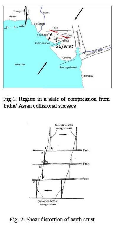
1 Influence of Local Soil Conditions on Ground Response and Damage Pattern Due to Earthquake Introduction Dr. Abdul Samad Khan The Earthquake of January 26, 2001 of magnitude 7.6 on Richter scale has resulted in more than 25,000 fatalities and wide spread damage in India and South- East lower part of Sindh, Pakistan. The Intensity of this earthquake was felt from severe to minor near the epicenter and areas within 400 km radius. It has been reported that severe damage has occurred to mid to high-rise buildings in the city of Ahmedabad (300 km East of the epicenter) whereas no damage was reported in the city of Karachi although it lie approximately the same distance (North-West of the epicenter). Wide spread liquefaction and lateral spreading of soils have been reported in Rann of Kutch (India) and in many part of the South -East Sindh (Badin, Taluka Mithi, Taluka Nangarparkar of Tharparkar). Several feet wide craters appeared / developed on and around Badin - Kadhan road. The ground vibration resulting from an earthquake is due to the upward transmission of the stress wave from rock (fault rupture) to the softer soil layer(s). These stress waves are body waves, which reach the surface at an angle depending upon the distance of the surface point from the epicenter or point on the surface over the origin. These body waves may generate two other surface waves, which are confined, to elastic-half-space and are known as "Raleigh wave" and "love wave". The seismograph may also record the ground motions of these waves, which are complex in nature. Based on theories, documented informations for January, 2001 earthquake and published research work on earthquakes, the author has tried to demonstrate the effect of local soil conditions on earth ground-motion / shaking (response) and damage patterns due to such ground shaking. The Mechanism for Earthquake, January 26, 2001 Triggering Rocks in the region are primarily Jurassic to cretaceous age sedimentary and volcanic rocks. The earthquakes in India and Pakistan are the result of the compression thrust of Eurasian Plate with Indian Plate. The neotectonic geology of Kutch (Malik et. al 2000) consists of a series of folds and faults with a general WNW/ESE trend. The region is still in a state of compression from India / Asian collision stresses (Fig.1) When for some mechanical reason a fault is prevented from continuing its normal relative displacement, first a distortion takes place with the accumulation of potential energy as indicated in the Fig. 2 by the dashed line. When the ultimate frictional resistance of the rock at the fault is reached, the potential energy stored is suddenly released into kinetic energy, giving rise to seismic motion producing waves that travel in all directions. The rock previously distorted has the tendency to spring back to approximately the positions (a 1 -a 1 ), (b 1 -b 1.). as shown in Fig. 2. The kinetic energy 1
2 of the waves is dissipated in the earth crust with distance from the source and its magnitude is registered at various intensities at the locations through which the body waves pass. It is also possible that multiple total reflections within the upper layer in the Bhuj area might have generated a surface waves called "Love waves". In the opinion of the author these are the waves, which have resulted in damages to building in Bhuj area and Ahmedabad city. Fig. 3 shows some of the faults mapped by Malik et al The Kutch region appears to be one area where above-normal seismicity rates exist. It will be interesting to discover whether a correspondingly higher than normal strain-rate prevails in the region and if so why? The Allah Bund fault is close to eastern boarder and if this fault extends westward due to tectonic movement than it has serious consequences for earthquake hazard in Karachi. Location and Data Related to Fault INDIA USGS Latitude N N Longitude E E Focus 22 km 23.6 km Magnitude Duration 45 Seconds 45 Seconds It is surmise that the rupture occurred on a pre-existing fault although researchers found no direct evidence of such a fault on the place of rupture (NSF - SCEC Survey Team). Liquefaction and Ground Deformation One of the major causes of destruction during an earthquake is the failure of the ground surface. The ground may fail due to fissures, abnormal or unequal settlement or complete loss of shear strength of soil. A loose saturated sand deposit when subjected to vibration (or cyclic loading) tends to compact and decrease in volume. If drainage is unable to occur, the pore water pressure increases. Fig.4 shows a typical set of results from Seed and Lee (1966) for repeated load triaxial test. The pressure had been building up during the first eight cycles & in the ninth cycle the pore pressure become equal to the confining stress so that the lateral effective stress dropped to zero. Based on the effective stress principle the shearing strength of saturated sand is given by shearing strength equation, τ = ( σn u) tanφ During longer shaking of loose saturated sand deposit, increase pore Pressure (u) become equal to the overburden stresses (σ n ) and the ground lost its complete shearing strength resulting in settlements and tilting of structures. Loss of strength during cyclic loading occurs in clays also but loss of strength does not occur until after very large strains have already developed. 2
3 Liquefaction features which include lateral spreads, sand blows, sand blow craters for the earthquake in coastal areas of Run of Kutch and Sindh are shown in Plate 1 through plate 6 for comparison purposes. In many parts of the coastal district of Sindh, several feet wide craters also appeared on ground as in India. At a number of places subsoil water sprang from the earth. It appears that no earthquake have ever hit this part as powerfully as it did on January 26, 2001? Effects of Local Geology and Soil Conditions on Ground Response In the preceding section it is shown that a particular sandy soil under certain conditions lost its strength. MacMurdo (1823) in describing the effects of the earthquake near the Run of Kutch in 1819 noted that, "Buildings situated on rock were not by any means so much affected by the earthquake as those whose foundations did not reach to the bottom of the soil" Kanai et al (1959) in Japan have shown that during small earthquakes, the ground surface accelerations on soil deposit are usually considerably higher than those occurring on adjacent rock exposures. In the 1957 San Francisco Earthquake, recording of ground motions were made at several locations within the city. Using these recorded motions as a basis for analysis, Seed (1977) has shown that the maximum base shear for a typical. 10-storey building located at each of the recording sites varied by several hundred percent, from relatively low values for sites underlain by rock or shallow soils to much higher values at sites underlain by about 300 ft of clay & sand as shown in Fig. 5. The influence of different geologic conditions along the travel paths for seismic waves could also be investigated analytically. The results of such a study by Lysmer and Drake of the variations in amplitudes of Love waves at the surface of a rock formation with a structural discontinuity represented by a shale- filled valley. The computed surface amplitudes of the motions are shown in the Fig.6, the marked change in amplitudes and the irregular amplification of the motions along the surface of the shale are readily apparent. The ground motion near the surface of a soil deposit is mostly attributed to the upward propagation of shear wave from the under lying rock (S-wave, (m/sec) or rock like layer (soft rocks, shear velocity m/sec). Seed et at (1969) have shown that the rock like material may not exhibit the characteristic associated with hard base. Hence, for arriving at a solution of the nature of ground motion at or near the ground surface, one needs to know some aspects of the earthquake - induced motion in the rock or rock like materials. The most important of these are duration of the earthquake, predominant period of acceleration and maximum amplitude of motion. Using the results of other researchers, Seed et al (1969) developed chart (Fig. 7) for the average predominant period of accelerations for various earthquake magnitude as plotted against the distance from the causative fault. They also provided another chart (Fig. 8) with average values of maximum acceleration for various magnitudes of earthquakes and distances from the causative faults. A normalized average spectrum for different sites conditions based on statistical analysis of over hundred real recorded earthquake accerlograms is shown in Fig.9 (after Seed). It is readily apparent that soil introduced a significantly larger 3
4 proportion of larger period components into the ground surface motions, the effect increasing as the depth or softness of the soil increases. The above-mentioned site / soil effects on ground response revealed that some consideration of these effects in planning and design is clearly desirable in all seismically active region. Grounds and Building Damages at Places Away from Epicenter - January 26, 2001 Earthquake From the coastal area of Taluka Nangarparkar (Thalpharkar District) and Mithi it is reported that underground water from shallow wells has become saline, with lands close to salt mines are now submerged in saline water, which errupted in the form of powerful black water springs. Ground fissures / breaches have appeared in the land around that area. Crater developed on ground in some parts of Badin - Kadhan road and subsoil water sprang from the earth. The major building damages in Pakistan: the top floor of the three - story minaret of the shrine fell down after the earthquake jolts. The R.C.C roof and column of the Mirza & Khoshi Sugar Mills in Badin were badly damaged. The four-story building Ghousia Apartments in Hyderabad completely collapsed. Nearly eighty percent midto-high rise residential buildings were collapsed in the city of Ahmedabad (India) even though the city was 300 km (approx) east from the quake epicenter and much of the old town survived. It has been reported by OYO-RMS Survey Team that the most common damage to R.C structures in Ahmedabad with infill walls was the failure of beam-column connections (soft-story system) due to lack of lateral force resisting system, lack of column confinement, poor construction quality, no seismic detailing and poor soil conditions. Conclusion It has been shown that ground response during earthquake depends upon the soil conditions underlying a site. A gross instability of the soil may develop, resulting in large permanent movements of the ground surface and associated distortion of structures supported on it. The intensity of the earthquake movements should be studied in the form of displacements and accelerations, useful to seismic engineering profession. Therefore, it is important to record destructive earthquakes by means of accelerographs. From the recorded accelerations the response spectra for different/ location areas may be calculated. The results may be applied in seismic designing of foundation and structural engineering. A detailed seismo-geological study based on actual recorded earthquakes (accelerograms) of lower Sindh including Karachi is urgently required to access the site-specific seismic hazards. For this purpose it is suggested that a seismographic station may be established at NED University of Engineering & Technology, Karachi. 4
5 References Kanai, K., Tanaka, T. and Yoshizawa S. (1959) "Comparative Studies of Earthquake Motions on the Ground and Underground (Multiple Reflection Problem". Bulletin of the Earthquake Research Institute, Vol. 37, Part 1, March, PP MacMurdo, J (1823), Paper, Relating to the Earthquake which Occurred in India in 1819, Trans. Literary Soc. Bombay 3, Malik J. N, Sohoni P.S, Merh, S.S and Karanth R.V (2000), Proceeding of the Hokudan International Symposium and School on Active Faulting Okumera K, Goto, H. & Takada, K. eds Seed, H. B., K.L. Lee, 1966 "Liquefaction of Saturated Sands During Cyclic Loading," Proc ASCE, Vol. 92, No SM 6, PP Seed, H.B., Idriss, I.H, and Kiefer, F.W (1969)." Characteristics of Rock Motion During Earthquakes", Jour. of the Soil Mechanics and Foundations Division, ASCE, 9 (SM-5), P Seed, H.B (1977), "Practical Seismic Design of Structures, Seminar, Structures Group, Metropolitan Section, ASCE, N.Y. 5
6 6
7 7
8 8
9 Fig. 7: Predominent period for maximum rock acceleration (after Seed et al.) Fig. 8: Variation of maximum acceleration with earthquake magnitud and distance from causative fault. ( after Seed et al) 9
10 Fig 9: Average Spectra for different site conditions (after Seed) 10
11 Plate 1: Badin- Kadhan road (5 km away from Kadhan): Craters in the earth are clearly visible (Pakistan). Plate 2: Badin-Kadhan road (5km away from Kadhan): Sugar cane lands were devastated by large earth fissures (Pakistan). 11
12 Plate 3: Sand blow in mud flats used for salt production southwest of Kandla Port (India). Plate 4: Sand blow and water-filled crater at Umedpur (India). 12
13 Plate 5: Badin-Kadhan road: 5 km away from Kadhan. Earth fissured and the black top road vanished under silt that erupted along with water from the ground (Pakistan). Plate 6: Zone of ground fissures and cracks at village south of Manfara (India). 13
Earthquakes and Earth s Interior
 - What are Earthquakes? Earthquakes and Earth s Interior - The shaking or trembling caused by the sudden release of energy - Usually associated with faulting or breaking of rocks - Continuing adjustment
Section Forces Within Earth. 8 th Grade Earth & Space Science - Class Notes
 Section 19.1 - Forces Within Earth 8 th Grade Earth & Space Science - Class Notes Stress and Strain Stress - is the total force acting on crustal rocks per unit of area (cause) Strain deformation of materials
Section 19.1: Forces Within Earth Section 19.2: Seismic Waves and Earth s Interior Section 19.3: Measuring and Locating.
 CH Earthquakes Section 19.1: Forces Within Earth Section 19.2: Seismic Waves and Earth s Interior Section 19.3: Measuring and Locating Earthquakes Section 19.4: Earthquakes and Society Section 19.1 Forces
UGRC 144 Science and Technology in Our Lives/Geohazards
 UGRC 144 Science and Technology in Our Lives/Geohazards Session 3 Understanding Earthquakes and Earthquake Hazards Lecturer: Dr. Patrick Asamoah Sakyi Department of Earth Science, UG Contact Information:
Earthquakes. Building Earth s Surface, Part 2. Science 330 Summer What is an earthquake?
 Earthquakes Building Earth s Surface, Part 2 Science 330 Summer 2005 What is an earthquake? An earthquake is the vibration of Earth produced by the rapid release of energy Energy released radiates in all
Important Concepts. Earthquake hazards can be categorized as:
 Lecture 1 Page 1 Important Concepts Monday, August 17, 2009 1:05 PM Earthquake Engineering is a branch of Civil Engineering that requires expertise in geology, seismology, civil engineering and risk assessment.
Forces in Earth s Crust
 Name Date Class Earthquakes Section Summary Forces in Earth s Crust Guide for Reading How does stress in the crust change Earth s surface? Where are faults usually found, and why do they form? What land
Elastic Rebound Theory
 Earthquakes Elastic Rebound Theory Earthquakes occur when strain exceeds the strength of the rock and the rock fractures. The arrival of earthquakes waves is recorded by a seismograph. The amplitude of
Earthquakes Chapter 19
 Earthquakes Chapter 19 Does not contain complete lecture notes. What is an earthquake An earthquake is the vibration of Earth produced by the rapid release of energy Energy released radiates in all directions
LAB 9: Earthquakes & Seismic Activity
 LAB 9: Earthquakes & Seismic Activity Objectives Identify P, S, and surface waves on a simple seismogram Locate the epicenter of an earthquake using seismograms and travel times curves Describe how the
I. Locations of Earthquakes. Announcements. Earthquakes Ch. 5. video Northridge, California earthquake, lecture on Chapter 5 Earthquakes!
 51-100-21 Environmental Geology Summer 2006 Tuesday & Thursday 6-9:20 p.m. Dr. Beyer Earthquakes Ch. 5 I. Locations of Earthquakes II. Earthquake Processes III. Effects of Earthquakes IV. Earthquake Risk
Earthquakes Earth, 9th edition, Chapter 11 Key Concepts What is an earthquake? Earthquake focus and epicenter What is an earthquake?
 1 2 3 4 5 6 7 8 9 10 Earthquakes Earth, 9 th edition, Chapter 11 Key Concepts Earthquake basics. "" and locating earthquakes.. Destruction resulting from earthquakes. Predicting earthquakes. Earthquakes
Earthquakes and Earthquake Hazards Earth - Chapter 11 Stan Hatfield Southwestern Illinois College
 Earthquakes and Earthquake Hazards Earth - Chapter 11 Stan Hatfield Southwestern Illinois College What Is an Earthquake? An earthquake is the vibration of Earth, produced by the rapid release of energy.
Earthquakes.
 Earthquakes http://quake.usgs.gov/recenteqs/latestfault.htm An earthquake is a sudden motion or shaking of the Earth's crust, caused by the abrupt release of stored energy in the rocks beneath the surface.
Earthquakes & Volcanoes
 Earthquakes & Volcanoes Geology - the study of solid Earth, the rocks of which it is composed, and the processes by which they change geo = Earth; ology = study of Earth s Layers Plate Tectonics - the
Earthquakes How and Where Earthquakes Occur
 Earthquakes How and Where Earthquakes Occur PPT Modified from Troy HS Is there such thing as earthquake weather? Absolutely NOT!!! Geologists believe that there is no connection between weather and earthquakes.
Micro Seismic Hazard Analysis
 Micro Seismic Hazard Analysis Mark van der Meijde INTERNATIONAL INSTITUTE FOR GEO-INFORMATION SCIENCE AND EARTH OBSERVATION Overview Site effects Soft ground effect Topographic effect Liquefaction Methods
Liquefaction and Foundations
 Liquefaction and Foundations Amit Prashant Indian Institute of Technology Gandhinagar Short Course on Seismic Design of Reinforced Concrete Buildings 26 30 November, 2012 What is Liquefaction? Liquefaction
Earthquake. What is it? Can we predict it?
 Earthquake What is it? Can we predict it? What is an earthquake? Earthquake is the vibration (shaking) and/or displacement of the ground produced by the sudden release of energy. Rocks under stress accumulate
2.3 Notes: Earthquake Damage Can Be Reduced
 2.3 Notes: Earthquake Damage Can Be Reduced Earthquakes can cause severe damage and loss of life Each year, there is about one earthquake with a magnitude of or higher-this is an extremely earthquake.
What is an Earthquake?
 Earthquakes What is an Earthquake? Earthquake - sometimes violent shaking of ground caused by movement of Earth s tectonic plates; creates seismic waves Often followed by smaller earthquakes (aftershocks);
Earthquakes and Earth s Chapter. Interior
 Earthquakes and Earth s Chapter Interior 8.1 What Is an Earthquake? An earthquake is the vibration of Earth produced by the rapid release of energy Focus and Epicenter Focus is the point within Earth
Magnitude 6.3 SOUTH ISLAND OF NEW ZEALAND
 A magnitude 6.3 earthquake shook the southern New Zealand city of Christchurch. At least 100 people are reported dead, and there are reports of collapsed buildings, cracked streets and flooding due to
Earthquakes.
 Earthquakes http://thismodernworld.com/comic-archive Elastic rebound http://projects.crustal.ucsb.edu/understanding/elastic/rebound.html Elastic rebound Rocks store energy elastically When stored stress
Earthquakes. Forces Within Eartth. Faults form when the forces acting on rock exceed the rock s strength.
 Earthquakes Vocabulary: Stress Strain Elastic Deformation Plastic Deformation Fault Seismic Wave Primary Wave Secondary Wave Focus Epicenter Define stress and strain as they apply to rocks. Distinguish
Slide 1. Earth Science. Chapter 5 Earthquakes
 Slide 1 Earth Science Chapter 5 Earthquakes Slide 2 Forces in Earth's Crust A force that acts on rock to change its shape or volume is stress 3 types of stress acting on rock layers Tension pulls on the
Science Starter. Describe in your own words what an Earthquake is and what causes it. Answer The MSL
 Science Starter Describe in your own words what an Earthquake is and what causes it. Answer The MSL WHAT IS AN EARTHQUAKE AND HOW DO WE MEASURE THEM? Chapter 8, Section 8.1 & 8.2 Looking Back Deserts Wind-shaped
Prentice Hall EARTH SCIENCE
 Prentice Hall EARTH SCIENCE Tarbuck Lutgens Chapter 8 Earthquakes and Earth s Interior 8.1 What Is an Earthquake? Earthquakes An earthquake is the vibration of Earth produced by the rapid release of energy
Dangerous tsunami threat off U.S. West Coast
 Earthquakes Ch. 12 Dangerous tsunami threat off U.S. West Coast Earthquakes What is an Earthquake? It s the shaking and trembling of the Earth s crust due to plate movement. The plates move, rocks along
Part 2 - Engineering Characterization of Earthquakes and Seismic Hazard. Earthquake Environment
 Part 2 - Engineering Characterization of Earthquakes and Seismic Hazard Ultimately what we want is a seismic intensity measure that will allow us to quantify effect of an earthquake on a structure. S a
Determining the Earthquake Epicenter: Japan
 Practice Name: Hour: Determining the Earthquake Epicenter: Japan Measuring the S-P interval There are hundreds of seismic data recording stations throughout the United States and the rest of the world.
Seismic Waves. 1. Seismic Deformation
 Types of Waves 1. Seismic Deformation Seismic Waves When an earthquake fault ruptures, it causes two types of deformation: static; and dynamic. Static deformation is the permanent displacement of the ground
22.5 Earthquakes. The tsunami triggered by the 2004 Sumatra earthquake caused extensive damage to coastal areas in Southeast Asia.
 The tsunami triggered by the 2004 Sumatra earthquake caused extensive damage to coastal areas in Southeast Asia. An earthquake is a movement of Earth s lithosphere that occurs when rocks in the lithosphere
Y. Shioi 1, Y. Hashizume 2 and H. Fukada 3
 Y. Shioi 1, Y. Hashizume 2 and H. Fukada 3 1 Emeritus Professor, Hachinohe Institute of Technology, Hachinohe, Japan 2 Chief Engineer, Izumo, Misawa, Aomori, Japan 3 Profesr, Geo-Technical Division, Fudo
Earthquake Hazards. Tsunami
 Earthquake Hazards Tsunami Review: What is an earthquake? Earthquake is the vibration (shaking) and/or displacement of the ground produced by the sudden release of energy. The point inside the Earth where
Liquefaction Potential Post-Earthquake in Yogyakarta
 The 17 th Southeast Asian Geotechnical Conference Taipei, Taiwan, May 10~13, 2010 Liquefaction Potential Post-Earthquake in Yogyakarta AGUS SETYO MUNTOHAR 1 and S.P.R. WARDANI 2 1 Department of Civil Engineering,
Address for Correspondence
 Research Paper DYNAMIC ANALYSIS OF KASWATI EARTH DAM 1 Patel Samir K., 2 Prof. C.S.Sanghavi Address for Correspondence 1 Applied Mechanics Department, 2 Professor, L. D. College of Engineering, Gujarat
Cyclic Behavior of Sand and Cyclic Triaxial Tests. Hsin-yu Shan Dept. of Civil Engineering National Chiao Tung University
 Cyclic Behavior of Sand and Cyclic Triaxial Tests Hsin-yu Shan Dept. of Civil Engineering National Chiao Tung University Causes of Pore Pressure Buildup due to Cyclic Stress Application Stress are due
Earthquake Hazards. Tsunami
 Earthquake Hazards Tsunami Measuring Earthquakes Two measurements that describe the power or strength of an earthquake are: Intensity a measure of the degree of earthquake shaking at a given locale based
Internal Layers of the Earth
 Lecture #4 notes Geology 3950, Spring 2006; CR Stern Seismic waves, earthquake magnitudes and location, and internal earth structure (pages 28-95 in the 4 th edition and 28-32 and 50-106 in the 5 th edition)
Earthquakes = shaking of Earth because of a rapid release of energy
 There are more than 30,000 earthquakes worldwide each year! Earthquakes = shaking of Earth because of a rapid release of energy usually because of movement of tectonic plates Most earthquakes last for
UNIT - 7 EARTHQUAKES
 UNIT - 7 EARTHQUAKES WHAT IS AN EARTHQUAKE An earthquake is a sudden motion or trembling of the Earth caused by the abrupt release of energy that is stored in rocks. Modern geologists know that most earthquakes
Earthquakes. Earthquakes and Plate Tectonics. Earthquakes and Plate Tectonics. Chapter 6 Modern Earth Science. Modern Earth Science. Section 6.
 Earthquakes Chapter 6 Modern Earth Science Earthquakes and Plate Tectonics Section 6.1 Modern Earth Science Earthquakes and Plate Tectonics Earthquakes are the result of stresses in Earth s s lithosphere.
Earthquakes. Chapter Test A. Multiple Choice. Write the letter of the correct answer on the line at the left.
 Earthquakes Chapter Test A Multiple Choice Write the letter of the correct answer on the line at the left. 1. Stress that pushes a mass of rock in two opposite directions is called a. shearing. b. tension.
20.1 Earthquakes. Chapter 20 EARTHQUAKES AND VOLCANOES. Earthquakes and plate boundaries 500 UNIT 6 EARTH S STRUCTURE
 Chapter 20 EARTHQUAKES AND VOLCANOES 20.1 Earthquakes In Chapter 19, you read about the San Andreas Fault, which lies along the California coast (Figure 20.1). This fault passes right through San Francisco
A. rift valley B. deep trench C. volcanic cone D. uplifted mountain. A. a volcanic island arc B. a large watershed area
 DC Practice Test Dynamic Crust PRCTICE TEST Zimm's Earth Science 2013 1. Which feature would most likely be forming at converging continental tectonic plate boundaries?. rift valley. deep trench C.
Topic 5: The Dynamic Crust (workbook p ) Evidence that Earth s crust has shifted and changed in both the past and the present is shown by:
 Evidence that Earth s crust has shifted and changed in both the past and the present is shown by:") Topic 5: The Dynamic Crust (workbook p. 65-85) Evidence that Earth s crust has shifted and changed in both the past and the present is shown by: --sedimentary horizontal rock layers (strata) are found
Topic 5: The Dynamic Crust (workbook p. 65-85) Evidence that Earth s crust has shifted and changed in both the past and the present is shown by: --sedimentary horizontal rock layers (strata) are found
Assessment Schedule 2015 Earth and Space Science: Demonstrate understanding of the causes of extreme Earth events in New Zealand (91191)
") NCEA Level 2 Earth and Space Science (91191) 2015 page 1 of 6 Assessment Schedule 2015 Earth and Space Science: Demonstrate understanding of the causes of extreme Earth events in New Zealand (91191) Evidence
NCEA Level 2 Earth and Space Science (91191) 2015 page 1 of 6 Assessment Schedule 2015 Earth and Space Science: Demonstrate understanding of the causes of extreme Earth events in New Zealand (91191) Evidence
ONE DIMENSIONAL GROUND RESPONSE ANALYSIS OF COASTAL SOIL NEAR NALIYA, KUTCH, GUJARAT
 IGC 29, Guntur, INDIA ONE DIMENSIONAL GROUND RESPONSE ANALYSIS OF COASTAL SOIL NEAR NALIYA, KUTCH, GUJARAT T.P. Thaker Research Scholar, Department of Civil Engineering, Indian Institute of Technology
SLOPE STABILITY EVALUATION AND ACCEPTANCE STANDARDS
 INFORMATION BULLETIN / PUBLIC - BUILDING CODE REFERENCE NO.: LABC 7006.3, 7014.1 Effective: 01-01-2017 DOCUMENT NO.: P/BC 2017-049 Revised: 12-21-2016 Previously Issued As: P/BC 2014-049 SLOPE STABILITY
Characteristics of a Force Loads on Structures. Dead Load. Load Types Dead Live Wind Snow Earthquake. Load Combinations ASD LRFD
 Architecture 314 Structures I Characteristics of a Force Loads on Structures Load Types Dead Live Wind Snow Earthquake Load Combinations ASD LRFD University of Michigan, TCAUP Structures I Slide 1 of 27
Elastic rebound theory
 Elastic rebound theory Focus epicenter - wave propagation Dip-Slip Fault - Normal Normal Fault vertical motion due to tensional stress Hanging wall moves down, relative to the footwall Opal Mountain, Mojave
Date: April 2, 2014 Project No.: Prepared For: Mr. Adam Kates CLASSIC COMMUNITIES 1068 E. Meadow Circle Palo Alto, California 94303
 City of Newark - 36120 Ruschin Drive Project Draft Initial Study/Mitigated Negative Declaration Appendix C: Geologic Information FirstCarbon Solutions H:\Client (PN-JN)\4554\45540001\ISMND\45540001 36120
Figure Diagram of earth movements produced by (a) P-waves and (b) S-waves.
 P-waves and (b) S-waves.") Geology 101 Name(s): Lab 10: Earthquakes When the stresses in a rock (which may or may not already be faulted) exceed the tensile strength of the rock, the rock ruptures at a point called the focus or
Geology 101 Name(s): Lab 10: Earthquakes When the stresses in a rock (which may or may not already be faulted) exceed the tensile strength of the rock, the rock ruptures at a point called the focus or
Name Date Class. radiate in all directions, carrying some of the. of plate boundaries have different usual patterns of.
 Chapter Outline Earthquakes CHAPTER 6 Lesson 1: Earthquakes and Plate Boundaries A. What is an earthquake? 1. A(n) is the rupture and sudden movement of rocks along a fault. A fault is a fracture surface
Earthquakes 11/14/2014. Earthquakes Occur at All Boundaries. Earthquakes. Key Aspects of an Earthquake. Epicenter. Focus
 Earthquakes Earthquakes Caused by friction and movement between Earth s tectonic plates A release of force Often caused by a catch between two plates As plates slide by, they stick to each other When the
Effective stress analysis of pile foundations in liquefiable soil
 Effective stress analysis of pile foundations in liquefiable soil H. J. Bowen, M. Cubrinovski University of Canterbury, Christchurch, New Zealand. M. E. Jacka Tonkin and Taylor Ltd., Christchurch, New
Earthquake Investigation
 Exploration A Earthquake Investigation 1. Obtain a piece of plastic putty and knead it into a rectangular shape. 2. Push the ends of the putty toward the middle. Draw and describe what it looks like below.
Earthquake Hazards. Tsunami
 Earthquake Hazards Tsunami Review: What is an earthquake? Earthquake is the vibration (shaking) and/or displacement of the ground produced by the sudden release of energy. The point inside the Earth where
on the earthquake's strength. The Richter scale is a rating of an earthquake s magnitude based on the size of the
 Earthquakes and Seismic Waves An earthquake is the shaking and trembling that results from the movement of rock beneath Earth's surface. The point beneath Earth s surface where rock under stress breaks
Evaluation of Pore Water Pressure Characteristics in Embankment Model.
 Evaluation of Pore Water Pressure Characteristics in Embankment Model. Abdoullah Namdar and Mehdi Khodashenas Pelkoo Mysore University, Mysore, India. 76. Amirkabir University, Department of Mining Engineering,
PHYSICAL SCIENCE FINAL
 PHYSICAL SCIENCE FINAL Liquefaction Doreen Wallace, Tesla Grogan, Amber Ward, Erik Garcia, Cinthia Salas, Alexis Albers Liquefaction What is it? Conditions needed How it works Effects of Liquefaction Soil
An eyewitness account of the Bhuj earthquake
 An eyewitness account of the Bhuj earthquake M K Gupta India Meteorological Department, Pune 411 005, India. The occurrence of a severe earthquake is a rare event with its effect localized in a limited
Objectives. Vocabulary
 Forces Within Earth Objectives Define stress and strain as they apply to rocks. Distinguish among the three types of faults. Contrast three types of seismic waves. Vocabulary stress strain fault primary
Earthquakes and Faulting
 Earthquakes and Faulting Crustal Strength Profile Quakes happen in the strong, brittle layers Great San Francisco Earthquake April 18, 1906, 5:12 AM Quake lasted about 60 seconds San Francisco was devastated
21. Earthquakes I (p ; 306)
") 21. Earthquakes I (p. 296-303; 306) How many people have been killed by earthquakes in the last 4,000 years? How many people have been killed by earthquakes in the past century? What two recent earthquakes
21. Earthquakes I (p. 296-303; 306) How many people have been killed by earthquakes in the last 4,000 years? How many people have been killed by earthquakes in the past century? What two recent earthquakes
Study of the liquefaction phenomenon due to an earthquake: case study of Urayasu city
 Disaster Management and Human Health Risk III 311 Study of the liquefaction phenomenon due to an earthquake: case study of Urayasu city S. Kamao 1, M. Takezawa 1, K. Yamada 1, S. Jinno 1, T. Shinoda 1
SOME OBSERVATIONS RELATED TO LIQUEFACTION SUSCEPTIBILITY OF SILTY SOILS
 SOME OBSERVATIONS RELATED TO LIQUEFACTION SUSCEPTIBILITY OF SILTY SOILS Upul ATUKORALA 1, Dharma WIJEWICKREME 2 And Norman MCCAMMON 3 SUMMARY The liquefaction susceptibility of silty soils has not received
Ömer AYDAN. Ismail FEBRIN. Fumihiko IMAMURA KOGAMI (Tsunami Alert Community-NPO)
") ( ) JSCE-JAEE Team Andalas University Ömer AYDAN Ismail FEBRIN Fumihiko IMAMURA Abdul HAKAM Mas MERA KOGAMI (Tsunami Alert Community-NPO) Tomoji SUZUKI Patra Rina DEWI 10 4 10 9 LOCATION Padang Sikuai
( ) JSCE-JAEE Team Andalas University Ömer AYDAN Ismail FEBRIN Fumihiko IMAMURA Abdul HAKAM Mas MERA KOGAMI (Tsunami Alert Community-NPO) Tomoji SUZUKI Patra Rina DEWI 10 4 10 9 LOCATION Padang Sikuai
CHAPTER 1 BASIC SEISMOLOGY AND EARTHQUAKE TERMINOLGY. Earth Formation Plate Tectonics Sources of Earthquakes...
 CHAPTER 1 BASIC SEISMOLOGY AND EARTHQUAKE TERMINOLGY Earth Formation... 1-2 Plate Tectonics... 1-2 Sources of Earthquakes... 1-3 Earth Faults... 1-4 Fault Creep... 1-5 California Faults... 1-6 Earthquake
EQ Monitoring and Hazards NOTES.notebook. January 07, P-wave. S-wave. surface waves. distance
 Earthquake Monitoring and Hazards Reading a Seismogram General guidelines: P-wave First disruption of trace = Second disruption of trace = surface waves Largest disruption of trace = Not the distance to
Earthquakes. Pt Reyes Station 1906
 Earthquakes Pt Reyes Station 1906 Earthquakes Ground shaking caused by the sudden release of accumulated strain by an abrupt shift of rock along a fracture in the earth. You Live in Earthquake Country
Geology 229 Engineering Geology Lecture 27. Earthquake Engineering (Reference West, Ch. 18)
") Geology 229 Engineering Geology Lecture 27 Earthquake Engineering (Reference West, Ch. 18) Earthquake Engineering 1. General introduction of earthquakes 2. Seismic Hazards 3. Strong ground motion Exactly
Geology 229 Engineering Geology Lecture 27 Earthquake Engineering (Reference West, Ch. 18) Earthquake Engineering 1. General introduction of earthquakes 2. Seismic Hazards 3. Strong ground motion Exactly
ES 104 # 5 EARTHQUAKES:
 ES 104 Laboratory # 5 EARTHQUAKES: Epicenter Determination, Seismic Waves, and Hazards Introduction Earthquakes are vibrations of Earth caused by large releases of energy that accompany volcanic eruptions,
Earth Science 1.3 The San Andreas Presearch SA2: Earthquake Faults in California
 Earth Science 1.3 The San Andreas Presearch SA2: Earthquake Faults in California I was awakened by a tremendous earthquake, and though I hadn t ever before enjoyed a storm of this sort, the strange thrilling
Seismic Stability of Tailings Dams, an Overview
 Seismic Stability of Tailings Dams, an Overview BY Gonzalo Castro, Ph.D., P.E. Principal International Workshop on Seismic Stability of Tailings Dams Case Western Reserve University, November 2003 Small
Seismic Hazard Switzerland. When, where, and how often does certain shaking occur in Switzerland?
 Seismic Hazard Switzerland When, where, and how often does certain shaking occur in Switzerland? Hazard The hazard map shows where and how often certain incidents of horizontal acceleration are likely.
Residual Deformation Analyses to Demonstrate the Effect of Thin Steel Sheet Piles on Liquefaction-Induced Penetration Settlement of Wooden Houses
 6 th International Conference on Earthquake Geotechnical Engineering 1-4 November 2015 Christchurch, New Zealand Residual Deformation Analyses to Demonstrate the Effect of Thin Steel Sheet Piles on Liquefaction-Induced
Earthquake hazards. Aims 1. To know how hazards are classified 2. To be able to explain how the hazards occur 3. To be able to rank order hazards
 Earthquake hazards Aims 1. To know how hazards are classified 2. To be able to explain how the hazards occur 3. To be able to rank order hazards Types of hazard Primary A direct result of the earthquake
Three Fs of earthquakes: forces, faults, and friction. Slow accumulation and rapid release of elastic energy.
 Earthquake Machine Stick-slip: Elastic Rebound Theory Jerky motions on faults produce EQs Three Fs of earthquakes: forces, faults, and friction. Slow accumulation and rapid release of elastic energy. Three
Module 6 LIQUEFACTION (Lectures 27 to 32)
") Module 6 LIQUEFACTION (Lectures 27 to 32) Lecture 31 Topics 6.6 EFFECTS OF LIQUEFACTION 6.6.1 Alteration of Ground Motion 6.6.2 Development of Sand Boils 6.6.3 Settlement 6.6.4 Settlement of Dry Sands
Module 6 LIQUEFACTION (Lectures 27 to 32) Lecture 31 Topics 6.6 EFFECTS OF LIQUEFACTION 6.6.1 Alteration of Ground Motion 6.6.2 Development of Sand Boils 6.6.3 Settlement 6.6.4 Settlement of Dry Sands
Earthquake. earthquake, epicenters in the U.S. Kobe, Japan deaths
 Kobe, Japan 1995 5000 deaths Earthquakes It is estimated that there are 500,000 detectable earthquakes in the world each year. 100,000 of those can be felt, and 100 of them cause damage. The world's deadliest
San Andreas Movie Can It Happen?
 San Andreas Movie Can It Happen? Learning Objectives (LO) Lecture 14: Faults and Quakes Read: Chapter 10 and 11 Homework #12 due Thursday 12pm What we ll learn today:! 1. Compare strike-slip to dip-slip
Collision and transform Boundaries
 Collision and transform Boundaries I. The collision boundary Sometimes when two plates move together they are both continental rather than one being continental and one being oceanic as at the destructive
Topic 12: Dynamic Earth Pracatice
 Name: Topic 12: Dynamic Earth Pracatice 1. Earth s outer core is best inferred to be A) liquid, with an average density of approximately 4 g/cm 3 B) liquid, with an average density of approximately 11
Chapter 13 Earthquakes and Earth s Interior
 Chapter 13 Earthquakes and Earth s Interior The crust of the Earth is made up of floating tectonic plates- huge continent-sized chunks of solid rock floating on molten rock. Rock masses along the boundaries
Warm-up #15. How does magma move throughout the mantle? What is another example of this movement in nature?
 Warm-up #15 How does magma move throughout the mantle? What is another example of this movement in nature? Earth s Structure Lithosphere = crust & upper mantle; tectonic plates Asthenosphere = lower mantle
Forces in the Earth s crust
 EARTHQUAKES Forces in the Earth s crust How does stress in the crust change Earth s surface? Where are faults usually found, and why do they form? What land features result from the forces of plate movement?
Geology and Earth Resources
 Geology and Earth Resources 1 A Layered Sphere Core dense, intensely hot metal! Mostly Fe and Ni! Inner and Outer Core Mantle - Hot, pliable layer, less dense! O 2, Si, Mg! Mesosphere (lower mantle)! Asthenosphere
Once you have opened the website with the link provided choose a force: Earthquakes
 Name: Once you have opened the website with the link provided choose a force: Earthquakes When do earthquakes happen? On the upper left menu, choose number 1. Read What is an Earthquake? Earthquakes happen
Directed Reading. Section: How and Where Earthquakes Happen WHY EARTHQUAKES HAPPEN. Skills Worksheet. 1. Define earthquake.
 Skills Worksheet Directed Reading Section: How and Where Earthquakes Happen 1. Define earthquake. 2. When do earthquakes usually occur? 3. What is a fault? WHY EARTHQUAKES HAPPEN 4. Rocks along both sides
AIM: What are the features of Earthquakes and where are they located? Do Now: What are some words that are associated with earthquakes?
 Notepack # 11 November 8, 201 AIM: What are the features of Earthquakes and where are they located? Do Now: What are some words that are associated with earthquakes? What are Earthquakes? The shaking or
An entire branch of Earth science, called, is devoted to the study of earthquakes.
 Lesson One Essential Question Where do earthquakes take place? What causes earthquakes? What are three different types of faults that occur at plate boundaries? How does energy from earthquakes travels
LECTURE #5: Plate Tectonics: Boundaries & Earthquake Science
 GEOL 0820 Ramsey Natural Disasters Spring, 2018 LECTURE #5: Plate Tectonics: Boundaries & Earthquake Science Date: 23 January 2018 I. Reminder: Exam #1 is scheduled for Feb 1st one week from Thursday o
appendix e: geologic and seismic hazards
 appendix e: geologic and seismic hazards CONTENTS: E-2 Fault Rupture E-3 Ground Shaking E-5 Seismic Ground Deformation E-5 Liquification E-6 Seismically Induces Landslide E-6 Landslide Hazard E The following
SEISMIC RESPONSE OF A SANDY STRATUM WITH A SILT LAYER UNDER STRONG GROUND MOTIONS
 SEISMIC RESPONSE OF A SANDY STRATUM WITH A SILT LAYER UNDER STRONG GROUND MOTIONS Bakhtiar Cahyandi Ridla 1), Huei-Tsyr Chen 2), M. Ruslin Anwar 3) 1) Double Degree Program E-mail: bakhtiar.ridla@gmail.com
Lecture Outline Wednesday-Monday April 18 23, 2018
 Lecture Outline Wednesday-Monday April 18 23, 2018 Questions? Lecture Final Exam Lecture Section 1 Friday May 4, 8:00-10:00am Lecture Section 2 Friday May 4, 3:10-5:10 pm Final Exam is 70% new material
Plate Tectonics IDEA THAT EARTH S SURFACE IS BROKEN INTO PLATES THAT MOVE AROUND. Fault = fracture in the crust where the movement has occurred
 Warm-up #14 A mountain range found 100 meters above sea level is measured to be 1,000 meters high from its tallest peak. From the top, the first 500 meters are incredibly steep. After this point, the mountain
[Hussain, 4(9): September 2017] ISSN DOI /zenodo Impact Factor
![[Hussain, 4(9): September 2017] ISSN DOI /zenodo Impact Factor](/thumbs/89/98828424.jpg "[Hussain, 4(9): September 2017] ISSN DOI /zenodo Impact Factor") GLOBAL JOURNAL OF ENGINEERING SCIENCE AND RESEARCHES SEISMIC ANALYSIS OF MULTI STOREYED BUILDING WITH SOFT STOREY Mohammed Irfan Hussain* *Asst. Professor, Department of Civil Engineering, Chaitanya Institute
GLOBAL JOURNAL OF ENGINEERING SCIENCE AND RESEARCHES SEISMIC ANALYSIS OF MULTI STOREYED BUILDING WITH SOFT STOREY Mohammed Irfan Hussain* *Asst. Professor, Department of Civil Engineering, Chaitanya Institute
REPORT ON THE TOHOKU AREA PASIFIC OFFSHORE EARTHQUAKE
 REPORT ON THE TOHOKU AREA PASIFIC OFFSHORE EARTHQUAKE GENERAL PERSPECTIVE The Highest Magnitude Ever Recorded The 2011 off the Pacific Coast of Tohoku Earthquake (hereafter, the 2011 Tohoku- Pacific Earthquake