Time-Series Displacement of Landslide In Danba County (China) Monitoried By the Small Baseline Subset (SBAS) technique
|
|
|
- Christian Price
- 5 years ago
- Views:
Transcription
1 Article Time-Series Displacement of Landslide In Danba County (China) Monitoried By the Small Baseline Subset (SBAS) technique Bo Hu 1, *,Yang Wu 1 1 Guangdong university of technology, Guangzhou, , China; hubo@asch.whigg.ac.cn; @qq.com ; *Author to whom correspondence should be addressed; hubo@asch.whigg.ac.cn; Tel. /Fax: Abstract: Landslide is a sliding movement of rock mass, debris and soil along the slope under the action of gravity. Small Baseline Subset (SBAS) is an established method for the investigation and monitoring of landslide moments. This study focuses on monitoring the long-temporal displacement of mountainous terrain in Danba County, Sichuan Province via SBAS technique, based on 31 scenes of L-band ALOS/PALSAR data from Feb to Oct The results show that the largest velocity rates in LOS direction are ±120 mm/yr and maximum accumulated displacement is up to -300, which indicates fast movement of the mountainous terrain during the observation time. These results get good consistency against the results of previous study. This demonstrates the strong potential of SBAS technique for monitoring the landslides geohazard. Keywords: SBAS; landslide; Danba; time-series; displacement 1. Introduction Landslide, refers to the slope failure in response to the increased ratio of destabilizing shear stress to resisting shear strength [1]. Nowadays, landslide has become a global geological issue that menaces the natural environment of human beings. Considered that landslide always appears on the brae and coteau area, and compared with the traditional leveling and global positioning system measurement methods, Interferometric synthetic aperture radar (InSAR) technique can obtain a millimeter-level precision with a wide range of subsidence [2]. InSAR is a new type of space-to-earth observation technique, taking full advantages of the phase information of the radar wave to measure surface deformation with high spatial resolution and high accuracy developed on the basis of SAR. However, problems due to changes in scattering properties of the Earth s surface with time and look direction limit the feasibility of InSAR [3]. To overcome the shortcomings of InSAR and retrieve long time-series subsidence data, the deformation velocity of highly coherent target points was computed by using least squares (LS) estimation [4]. Meanwhile, time-series InSAR techniques are proposed, including 2018 by the author(s). Distributed under a Creative Commons CC BY license.
2 Persistent Scatterer Interferometry (PS) [5,6], Small Baseline Subset(SBAS)[7,8], and Stanford Method for Persistent Scatterers (StaMPS) [9,10]. Among which SBAS technique combined multiple small baseline subsets by the singular value decomposition (SVD) method based on InSAR data pairs with small spatial and temporal baselines [11]. Therefore, it can effectively solve the low correlation caused by long spatial and temporal baselines among SAR data sets for the purpose of obtaining the deformation of high coherence targets during different periods. In recent years, InSAR technique was used widely to monitor landslide [12,13,14,15], earthquake [16,17,18], urban subsidence [19,20] and volcanic activities [21] as well as other crustal movement [22], and anthropogenic subsidence [23]. Recently, some researchers have investigated Danba County, especially Jiaju landslide using different techniques. Chengdu Geological Survey used D-InSAR technology to monitor the Jiaju landslide in Sichuan and obtained only two landslides, which results coincided well with GPS monitoring results [24]; Ao Meng et al. adopted an improved nonlinear artificial corner reflectors InSAR (CR-InSAR) algorithm based on phase coherence, which not only avoid the phase unwrapping error effectively, but also had the strong capability to detect the large scale deformation gradient [25]. Dong Jie et al. applied coherent scatterer InSAR (CSI) method to retrieve the historical displacement of the Jiaju landslide and found that the northern part of the landslide moved faster than the south part, exhibiting a maximum LOS displacement rate of around 120 mm/yr[26]. The aim of this paper is to (1) investigate the holistic displacement of Danba County and its surrounding area using SBAS method; (2) perform a time series analysis and make comparison with SBAS result and GPS measurement in identified landslide (Jiaju landslide); (3) detect two other region with large velocity rates of deformation and analyze the possibility that landslide occurred. 2. Study Area and Dataset 2.1. Study Area Danba, a big town in Sichuan Province, is located in the western region of Xiaojin town and the north of Kangting town. The geographical coordinates of Danba are N and E. Its length from north to south is km, and the south - north width is 86.9 km. Therefore, the covering of this area is approximately 5649 km 2. Danba town belongs to the Qinghai-Tibet plateau monsoon climate, and shows the vertical belt distribution. The temperature difference between the top of the mountain and river valley is 24. The annual average temperature is Danba s terrain is high in the west and low in the east. The lowest elevation is 1700m while the highest is 5820m. The landform of Danba town is mountainous type in mountains areas, which is made up by a set of linear fold in the parallel arrangement. And there is several fracture activity in Danba town, among which are mainly NW-trending, and Yuke-Danba fracture is the greatest impact on Danba s topography. It makes Danba s terrain show high elevation in the south and west of town and low elevation in the north and east of it. The study area as illustrated in Fig. 1.
 and the south part (15")
3 Figure 1. The location of the study area and the image coverage s of ALOS PALSAR data, the study area is outlined by two red rectangles Dataset Two sets of ALOS-PALSAR data from 7 February 2007 to 3 October 2010 were used, along the north part (16 scenes, path number: 478, frame number: 610, see Table 1a) and the south part (15 scenes, path number: 478, frame number: 600, see Table 1b) were employed to analyze the landslide of the area around Danba town. Moreover, this study adopted L wave band as the working wave band, both single-polarization and cross-polarization modes. And the digital elevation model (DEM) data required for processing were 30m elevation of ALOS Global Digital Surface Model ALOS World 3D - 30m (AW3D30). Table 1a. Imaging parameters and geometry of ALOS PALSAR-1 data used in the north part of Danba County Path 478 Direction Ascending Frame 610 Angle of Incident(") 34.5 No. Acquisition Date Acquisition Date No. (yyyy/mm/dd) (yyyy/mm/dd) /2/ Table 1b. Imaging parameters and geometry of ALOS PALSAR-1 data used in the south part ofdanba County Path 478 Direction Ascending Frame 600 Angle of Incident(") 34.5 No. Acquisition Date Acquisition Date No. (yyyy/mm/dd) (yyyy/mm/dd) /2/
4 Methodology Data processing starts with a stack of Single Look Complex (SLC) images. To minimize the effect of mis-corregistration caused by geometric, temporal, and Doppler decorrelation [27], all the SAR images are generated. In our study area, due to the vegetation covering and subtropical monsoon climate, the application of SAR interferometry is mainly limited by temporal decorrelation. Besides, the land reclamation related deformation has limited spatial range. We processed the datasets with SBAS technology, and below (Figure x) is a flow chart showing the strategy. Figure 2. Flow chart of the SBAS To minimize the effect of decorregistration caused by geometric, temporal, and Doppler, one of the advanced InSAR technology called small baseline subsets (SBAS) InSAR has been
5 improved and applied since 2002 [7]. Interferograms with small baselines that overlap in time are used in the algorithm for the sake of relieving topographic and atmospheric errors, and, furthermore, reducing the spatial decorrelation in the time-serises interferometric pairs. The differential phase for a coherent generic pixel of the range and azimuth coordinates (x,a) in j-interferogram that is generated by combining SAR acquisitions at times t Aand t Bis 4 [ d( t B, x, d( t ( x, ( t A i B, x, ( t 4 B j z, x, ] Rsin A, x, [ ( t, x, ( t, x, ] n, j 1, M (1) atm B atm A j, where λ is the transmitted signal central wavelength; φ(t A,x, and φ(t B,x, are the phases that correspond to times t Aand t B;d(t A,x, and d(t B,x, are the LOS projection of cumulative deformation at times t A and t B as the reference to the instant t 0, when φ(t 0,x,=0. The formula also includes a phase term that is connected with error Δz in the knowledge of the scene topography to generate differential interferograms. The impact of these artifacts depends on the orbit separation component B j, sensor target distance R, and beam incident angle θ. [φ atm(t B,x,-φ atm(t A,x,] is used to account for possible atmospheric signal. Finally, the term Δn jincludes decorrelation effects and other noise resources. Therefore, Equation (1) can be expressed as follows: disp ( x, j ( x, atm j ( x, noise j ( x, topo j ( x, (2) j where δφ disp, determined by Equation (3), is the slant displacement phase between times t Aand t B; δφ topo is the topographic phase error that is generated by external DEM; δφ atm is used to account for temporal atmospheric deformation obtained from different SAR acquisition; and δφ noise includes temporal decorrelation, orbital errors, thermal noise effects, etc [1]. The displacement between t Aand t B can be expressed as follows: disp 4 j ( x, v ( t (3) B 1 k A k k 1 t k ) where k shows the sequence index of SAR acquisition time between t A and t B, and v kindicates the mean phase velocity in the period from k to k+1. The cumulative displacement at different SAR acquisition times can be accounted by SVD methods when given M unwrapped interferograms. 4. Results 4.1. Spatio-temporal Baseline Optimization All interferometric pairs within the thresholds of the spatial and temporal baselines were drawn to generate SAR data pair connection diagram (Figure x) on account of a spatial baseline threshold, a temporal baseline threshold, and relative input parameters. In this study, the maximum normal baseline was set at 45%, the maximum temporal baseline was set at 200 days. The system automatically screened the super master image ( in the South Area and in the north area).


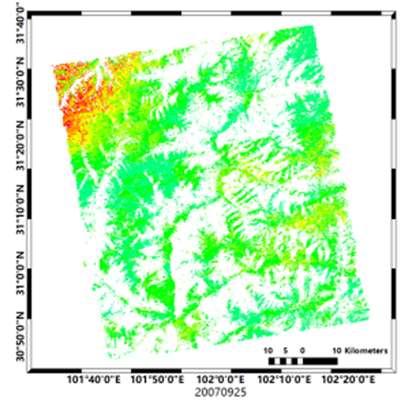
6 Figure 3. Time-baseline relevant to the ALOS PALSAR-1 images and interferograms used in this study. (a) refers to the north part of the study area while (b) refers to the south part of the study area Interferometry Results According to the relationship of their connection based on the selected parameters of SBAS technique, interferometry was carried out on each pair, and 51 interferograms of north part and 40 interferograms of south part were chosen to be processed finally. Afterwards, the total time-series cumulative phase subsidence diagrams were detected by refining, reflattening, phase unwrapping and geocoding. The locations and the average surface displacement velocity detected by SBAS technique in the study area are shown in Figure 4. The maximum settlement center is Jiaju, in which the deformation velocity even exceeds 120 mm/yr, in the LOS direction. The mean subsidence velocity map illustrates a stable pattern (-24 to 24 mm/y in the large proportion of this study. Moreover, the time-series images of these two database are collected in Figure 5 totally. Figure 4. Mean displacement velocity mas over the study area derived by SBAS technique. The first Figure is reflected in the LOS velocity of the north of the study are, while the second Figure expresses the LOS velocity of the south part. The red ellipses indicate the area in which violent subsidence take place (1,2,3). 1 is the summit of mountain, 2 is Jiaju village and 3 refers to Danba town..

7 (a)


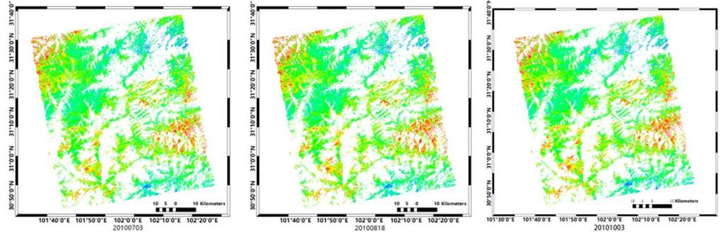
8 (b) Figure 5. Time-series results of SBAS in study area. 5(a) describes the time-series displacement in north of Danba town, and 5(b) shows the long-term subsidence in south of Danba town Validation by GPS measurements In order to estimate the accuracy and reliability of results processed by SBAS technique, we compare the time series displacements made by SBAS and GPS measurements. The time series displacement of these GPS monitoring stations are plotted in Figure.6. Generally, some parts of the results detected by SBAS technique match well with GPS measurements. As shown in Figure 6, the differences of displacement between GPS and SBAS results results are around 20 mm, and evolution trends are also similar. The differences between InSAR and GPS results may rely on a few factors, among which match of spatial between these two technique and the discontinuous observation are two key factors to make SBAS and GPS results have discrepancies. Normally, contrasted with GPS observations, the long-term, large-scale, all-day InSAR technique can provide measurement points at higher resolution, and detect more points than traditional measurements. (a)

 in the study area are chosen to be analyzed the time-series displacements (Figure 7).")
9 (b) Figure 6. (a)shows the position of 3 GPS monitoring stations G1 G2 and G3, (b) indicates time series displacements at 3 GPS monitoring stations shown in (a). The red rhombus and blue square are GPS and PALSAR, respectively. 5. Discussions It can be observed in Figure 3 that three large subsidences are detected in the study area, which are the summit of mountain. Jiaju village and Danba town. In order to intuitively analyze the subsidence of these three large displacements, some feature points (e.g., P1, P2, P3, P4, P5, P6, P7, P8, P9, P10) in the study area are chosen to be analyzed the time-series displacements (Figure 7). Thereinto, P1 to P3 belong to Ellipse I, the displacement of P4, P5, P6 are shown in Ellipse II, and P7 to P10 are in the Ellipse III, so that each zone can be detected via the displacements of points on them respectively. (a) (b)
10 Figure 7. The area contains Ellipse I, II and III. (a) include Ellipse I, and (b) comprises following two Ellipses Mountains (Ellipse I) In Ellipse I, the summit of mountains is covered with snow for most of year, and, to a great extent, snow melting can affect the displacement of this area. Figure 8 reveals the time series deformation of P1, P2, and P3. It can be known from Figure 8 that the displacements of P1, P2, and P3 are changing periodically while the general tendency is descending. They are upraised from Aug. to Feb. every year, and reach the zenith of a year for every Feburary. The accumulated displacement from Feb. 7, 2007 to Oct. 3, 2010 is -220mm, -240mm and -260mm seperatelly. Considered the geographic feature, it is deduced that the periodic change is caused by snow covered on the summit of the mountain and that there is a danger of landslide on the summit of mountain. Figure 8. The figure status the time-series displacement of P1, P2 and P3 within Ellipse I. The green, red, and blue line describe the tendency of subsidence of P1, P2 and P3 separately. 5.2 Jiaju village (Ellipse II) Jiaju village is rated as one of the most beautiful Chinese village.there is an area of landslide that was detected and called Jiaju landslide, which is 5.3 km far away from Danba town. The overall planar shape of Jiaju landslide is M 24, and the shape of the section is nearly stepped, which consists of two secondary landslides. The east-west average length is about 1200m and the mean width is about 1000m from north to south. The soil belongs to a large tractor in the deep soil landslide and the average thickness is 22m. There is no uniform sliding surface and main slip direction in the Jiaju landslide area, which is mainly manifested as multi-stage deformation. Three feature points P4, P5, P6 was chosen in this area. P4 is located in the top of Jiaju village, while P5 and P6 are situated near the roadside (Figure 9). From Figure 9, it can be known that between Feb and May 2008, the trend of displacement was descending. Then, this area was suffered lifting for about 6 months since Wenchuan Earthquake happened. And finally, it return to descend. Due to the values of these time-series of subsidences are more than -200mm even up to -300mm in these years, it is speculated that there is a possibility that the landslides occurred.
11 Figure 9. The figure is used to show the position and LOS time-series displacement of three typical points (P4, P5 and P6). Color green, red, and blue lines represent the displacement of P4 to P Danba town (Ellipse III) Danba town is a big county that numerous human lives, and it is surrounded by several mountains, in which landslide will cause larger destruction. So that the problem that prevents ruining of this area has become a serious problem. In order to obtain the time-series displacement of this area circled by Ellipse III, there are four typical points located in this area. Among them. P7 is on the southern hillside of Danba County; P10 is on the northern back hillside of Danba; P8 and P9 are the point with obvious displacement and are both located near different highway. It can be seen from Figure 10 that there is the same tendency of these points as P7, P8, P9 and P10 in Ellipse III between Feb and Jan Then, they became to decline and upraised from Oct to March The general displacement of these points are all less than -300mm. On account of the trend and the velocity of displacement from Jan to Oct were larger them those in the period from Feb to May 2008, and their variations since Jan were unstable, it was deduced that there was a small landslide in Danba County and its surrounding at that time. Figure 10. The figure shows the long-term variation of four typical points (P7, P8, P9 and P10) dipicted in Figure 6. The green, red, blue and pink lines respective refer to P7, P8, P9, P Conclusions In this study, SBAS technique allows us understand the annual velocity of subsidence under
12 orographic factor in Danba town and its surrounding areafrom investigating utilizing totally 31 ALOS PALSAR-1 data in the period between Feb and Oct The result in our paper reveals that the Danba County, especially Danba town, Jiaju village and the mountain located in northeast of Danba has experienced significant ground subsidence during the ALOS data period, in which the maximum average velocity in LOS direction is up to 120 and maximum accumulation exceeds 300 mm. We find that some uplift are occurred around Danba town after May 2008 in LOS direction, which may be caused by orbit error, inadequate operation of selecting the reference points, It is more likely unique phenomenon the havoc of 8.0 richer magnitude earthquake in Wenchuan. And we also observe that there is a saltus point in May 12, 2008 among the time-series displacement, which may be also influenced by the Wenchuan earthquake. Although we have not yet to find a more precise explanation, it should be the focus of our future work, and we will try to understand and explain this phenomenon counting on the spot measurements or high resolution SAR data, e.g., those acquired by TerraSAR-X, Cosmo-SkyMed, Radarsat-2 and Sentinel-1. Acknowledgments This work was supported by the Science and Technology Plan Project in Fujian Province (grant No. 2017Y3004) and by the National Natural Science Fundation of China (Grant No and ). We wish to thank the Japanese Aerospace Agency (JAXA) for arranging the ALOS PALSAR data and ALOS World 3D - 30m data. We also thank China Geological Survey for providing the GPS observation data. We thank the anonymous editor for their influential suggestions. Conflicts of Interest The authors declare no conflict of interest. References 1. Ma, C.; Cheng, X.; Yang, Y.; Zhang, X.; Guo, Z.; Zou, Y., Investigation on Mining Subsidence Based on Multi-Temporal InSAR and Time-Series Analysis of the Small Baseline Subset Case Study of Working Faces /2 in Bu ertai Mine, Shendong Coalfield, China. Remote Sensing 2016,8 (11), Galloway, D. L.; Burbey, T. J., Review: Regional land subsidence accompanying groundwater extraction. Hydrogeology Journal 2011,19 (8), Zhang, L.; Ding, X.; Lu, Z., Ground settlement monitoring based on temporarily coherent points between two SAR acquisitions. ISPRS Journal of Photogrammetry and Remote Sensing 2011,66 (1), Usai, S., A least squares database approach for SAR interferometric data. IEEE Transactions on Geoscience and Remote Sensing 2003,41 (4), Ferretti, A.; Prati, C.; Rocca, F., Permanent Scatterers in SAR Interferometry. IEEE Transactions on Geoscience and Remote Sensing 2001,39 (1), 8-20.
13 6. Ferretti, A.; Savio, G.; Barzaghi, R.; Borghi, A.; Musazzi, S.; Novali, F.; Prati, C.; Rocca, F., Submillimeter Accuracy of InSAR Time Series: Experimental Validation. IEEE Transactions on Geoscience and Remote Sensing 2007,45 (5), Berardino, P.; Fornaro, G.; Lanari, R.; Sansosti, E., A new algorithm for surface deformation monitoring based on small baseline differential SAR interferograms. IEEE Transactions on Geoscience and Remote Sensing 2002,40 (11), Zhou, L.; Guo, J.; Hu, J.; Li, J.; Xu, Y.; Pan, Y.; Shi, M., Wuhan Surface Subsidence Analysis in Based on Sentinel-1A Data by SBAS-InSAR. Remote Sensing 2017,9 (10), Hooper, A.; Segall, P.; Zebker, H., Persistent scatterer interferometric synthetic aperture radar for crustal deformation analysis, with application to Volcán Alcedo, Galápagos. Journal of Geophysical Research 2007,112 (B7). 10. Du, Y.; Feng, G.; Li, Z.; Peng, X.; Zhu, J.; Ren, Z., Effects of External Digital Elevation Model Inaccuracy on StaMPS-PS Processing: A Case Study in Shenzhen, China. Remote Sensing 2017,9 (11). 11. Lanari, R.; Mora, O.; Manunta, M.; Mallorqui, J. J.; Berardino, P.; Sansosti, E., A small-baseline approach for investigating deformations on full-resolution differential SAR interferograms. IEEE Transactions on Geoscience and Remote Sensing 2004,42 (7), Zhao, C.; Lu, Z.; Zhang, Q.; de la Fuente, J., Large-area landslide detection and monitoring with ALOS/PALSAR imagery data over Northern California and Southern Oregon, USA. Remote Sensing of Environment 2012,124, Teshebaeva, K.; Roessner, S.; Echtler, H.; Motagh, M.; Wetzel, H.-U.; Molodbekov, B., ALOS/PALSAR InSAR Time-Series Analysis for Detecting Very Slow-Moving Landslides in Southern Kyrgyzstan. Remote Sensing 2015,7 (7), Sun, Q.; Zhang, L.; Ding, X. L.; Hu, J.; Li, Z. W.; Zhu, J. J., Slope deformation prior to Zhouqu, China landslide from InSAR time series analysis. Remote Sensing of Environment 2015,156, Liu, P.; Li, Z.; Hoey, T.; Kincal, C.; Zhang, J.; Zeng, Q.; Muller, J.-P., Using advanced InSAR time series techniques to monitor landslide movements in Badong of the Three Gorges region, China. International Journal of Applied Earth Observation and Geoinformation 2013,21, Tralli, D. M.; Blom, R. G.; Zlotnicki, V.; Donnellan, A.; Evans, D. L., Satellite remote sensing of earthquake, volcano, flood, landslide and coastal inundation hazards. ISPRS Journal of Photogrammetry and Remote Sensing 2005,59 (4), Xu, G.; Xu, C.; Wen, Y.; Jiang, G., Source Parameters of the Central Italy Earthquake Sequence from the Sentinel-1, ALOS-2 and GPS Data. Remote Sensing 2017,9 (11), Lee, W.-J.; Lu, Z.; Jung, H.-S.; Ji, L., Measurement of small co-seismic deformation field from multi-temporal SAR interferometry: application to the 19 September 2004 Huntoon Valley earthquake. Geomatics, Natural Hazards and Risk 2017,8 (2), Lanari, R.; Lundgren, P.; Manzo, M.; Casu, F., Satellite radar interferometry time series analysis of surface deformation for Los Angeles, California. Geophysical Research Letters 2004,31 (23).
14 20. Zhou, L.; Zhang, D.; Wang, J.; Huang, Z.; Pan, D., Mapping Land Subsidence Related to Underground Coal Fires in the Wuda Coalfield (Northern China) Using a Small Stack of ALOS PALSAR Differential Interferograms. Remote Sensing 2013,5 (3), Wang, T.; DeGrandpre, K.; Lu, Z.; Freymueller, J. T., Complex surface deformation of Akutan volcano, Alaska revealed from InSAR time series. International Journal of Applied Earth Observation and Geoinformation 2018,64, Qu, F.; Zhang, Q.; Lu, Z.; Zhao, C.; Yang, C.; Zhang, J., Land subsidence and ground fissures in Xi'an, China revealed by multi-band InSAR time-series analysis. Remote Sensing of Environment 2014,155, Hu, B.; Wang, H.-S.; Sun, Y.-L.; Hou, J.-G.; Liang, J., Long-Term Land Subsidence Monitoring of Beijing (China) Using the Small Baseline Subset (SBAS) Technique. Remote Sensing 2014,6 (5), Yin, Y.; Zheng, W.; Liu, Y.; Zhang, J.; Li, X., Integration of GPS with InSAR to monitoring of the Jiaju landslide in Sichuan, China. Landslides 2010,7 (3), Ao, M.; zhang, q.; Zhao, C.; Liu, G., An Improed CR-InSAR Technoogy Used for Deformation Monitoring in Jiaju Landslide, Sichuan. Geomatics and Information Science of Wuhan University 2017,42 (3), Dong, J.; Zhang, L.; Tang, M.; Liao, M.; Xu, Q.; Gong, J.; Ao, M., Mapping landslide surface displacements with time series SAR interferometry by combining persistent and distributed scatterers: A case study of Jiaju landslide in Danba, China. Remote Sensing of Environment 2018,205, Xu, B.; Feng, G.; Li, Z.; Wang, Q.; Wang, C.; Xie, R., Coastal Subsidence Monitoring Associated with Land Reclamation Using the Point Target Based SBAS-InSAR Method: A Case Study of Shenzhen, China. Remote Sensing 2016,8 (8), 652.
Urban land and infrastructure deformation monitoring by satellite radar interferometry
 Urban land and infrastructure deformation monitoring by satellite radar interferometry Lei Zhang and Xiaoli Ding Department of Land Surveying and Geo-Informatics (LSGI) The Hong Kong Polytechnic University
Implementation of Multi-Temporal InSAR to monitor pumping induced land subsidence in Pingtung Plain, Taiwan
 Implementation of Multi-Temporal InSAR to monitor pumping induced land subsidence in Pingtung Plain, Taiwan Presenter: Oswald Advisor: Chuen-Fa Ni Date: March 09, 2017 Literature Review Pingtung Plain
Research Article Monitoring of Ground Deformation due to Excessive Withdrawal of Natural Gas Using SBAS
 Mathematical Problems in Engineering, Article ID 67451, 6 pages http://dx.doi.org/1.1155/214/67451 Research Article Monitoring of Ground Deformation due to Excessive Withdrawal of Natural Gas Using SBAS
High-resolution temporal imaging of. Howard Zebker
 High-resolution temporal imaging of crustal deformation using InSAR Howard Zebker Stanford University InSAR Prehistory SEASAT Topographic Fringes SEASAT Deformation ERS Earthquake Image Accurate imaging
MAPPING DEFORMATION OF MAN-MADE LINEAR FEATURES USING DINSAR TECHNIQUE
 MAPPING DEFORMATION OF MAN-MADE LINEAR FEATURES USING DINSAR TECHNIQUE H. Wu a, *, Y. Zhang a, J. Zhang a, X. Chen b a Key Laboratory of Mapping from Space of State Bureau of Surveying and Mapping, Chinese
Characterization of Landslide Deformations in Three Gorges Area Using Multiple InSAR Data Stacks
 Remote Sens. 2013, 5, 2704-2719; doi:10.3390/rs5062704 Article OPEN ACCESS Remote Sensing ISSN 2072-4292 www.mdpi.com/journal/remotesensing Characterization of Landslide Deformations in Three Gorges Area
ALOS PI Symposium 2009, 9-13 Nov 2009 Hawaii MOTION MONITORING FOR ETNA USING ALOS PALSAR TIME SERIES
 ALOS PI Symposium 2009, 9-13 Nov 2009 Hawaii ALOS Data Nodes: ALOS RA-094 and RA-175 (JAXA) MOTION MONITORING FOR ETNA USING ALOS PALSAR TIME SERIES Urs Wegmüller, Charles Werner and Maurizio Santoro Gamma
Radar Remote Sensing: Monitoring Ground Deformations and Geohazards from Space
 Radar Remote Sensing: Monitoring Ground Deformations and Geohazards from Space Xiaoli Ding Department of Land Surveying and Geo-Informatics The Hong Kong Polytechnic University A Question 100 km 100 km
P079 First Results from Spaceborne Radar Interferometry for the Study of Ground Displacements in Urban Areas SUMMARY
 P079 First Results from Spaceborne Radar Interferometry for the Study of Ground Displacements in Urban Areas C.M. Crosetto (Instituto de Geomatica), C.A. Casas (University of Barcelona), R.G. Ranieri (University
PERSISTENT SCATTERER INTERFEROMETRY: POTENTIAL AND LIMITS
 PERSISTENT SCATTERER INTERFEROMETRY: POTENTIAL AND LIMITS M. Crosetto a, O. Monserrat a, A. Jungner, B. Crippa b a Institute of Geomatics, Av. del Canal Olímpic, s/n, Castelldefels, E-08860, Spain (michele.crosetto,
Subsidence-induced fault
 Surveying Monitoring underground coal mining-induced subsidence by Yaobin Sheng, Linlin Ge, Chris Rizos, University of New South Wales, and Yunjia Wang, China University of Mining and Technology This paper
SAR interferometry Status and future directions. Rüdiger Gens
 SAR interferometry Status and future directions Rüdiger Gens Polarimetric InSAR Polarimetric InSAR InSAR - Status and future directions sensitivity to changes in surface scattering, even in the presence
Ground deformation monitoring in Pearl River Delta region with Stacking D-InSAR technique
 Ground deformation monitoring in Pearl River Delta region with Stacking DInSAR technique Zhao Qing*, LIN Hui, JIANG Liming Institute of Space and Earth Information Science, Room 615, Esther Lee Building,
DETECTING ICE MOTION IN GROVE MOUNTAINS, EAST ANTARCTICA WITH ALOS/PALSAR AND ENVISAT/ASAR DATA
 DETECTING ICE MOTION IN GROVE MOUNTAINS, EAST ANTARCTICA WITH ALOS/PALSAR AND ENVISAT/ASAR DATA TIAN Xin (1), LIAO Mingsheng (1), ZHOU Chunxia (2), ZHOU Yu (3) (1) State Key Laboratory of Information Engineering
ERS Track 98 SAR Data and InSAR Pairs Used in the Analysis
 ERS Track 98 SAR Data and InSAR Pairs Used in the Analysis Date 1 Date 2 Date 1 Date 2 Date 1 Date 2 Date 1 Date 2 7/17/1992 6/19/2000 7/17/1992 7/2/1993 9/10/1993 10/28/1996 9/3/1995 10/18/1999 9/25/1992
Journal of Geodynamics
 Journal of Geodynamics 49 (2010) 161 170 Contents lists available at ScienceDirect Journal of Geodynamics journal homepage: http://www.elsevier.com/locate/jog Recent advances on surface ground deformation
Landslide Monitoring in Three Gorges Area By Joint Use of Phase Based and Amplitude Based Methods
 Landslide Monitoring in Three Gorges Area By Joint Use of Phase Based and Amplitude Based Methods Xuguo Shi, Lu Zhang, Mingsheng Liao, Timo Balz LIESMARS, Wuhan University Outlines Introduction InSAR Results
The financial and communal impact of a catastrophe instantiated by. volcanoes endlessly impact on lives and damage expensive infrastructure every
 Chapter 1 Introduction The financial and communal impact of a catastrophe instantiated by geophysical activity is significant. Landslides, subsidence, earthquakes and volcanoes endlessly impact on lives
Dr. Simon Plank. German Remote Sensing Data Center (DFD), German Aerospace Center (DLR)
, German Aerospace Center (DLR)") Pre-survey suitability analysis of the differential and persistent scatterer synthetic ti aperture radar interferometry t method for deformation monitoring of landslides Dr. Simon Plank German Remote Sensing
Pre-survey suitability analysis of the differential and persistent scatterer synthetic ti aperture radar interferometry t method for deformation monitoring of landslides Dr. Simon Plank German Remote Sensing
Università di Roma La Sapienza, Facoltà d Ingegneria, Dipartimento di Idraulica,Trasporti e Strade (D.I.T.S.) 00185, Roma, Italy
 00185, Roma, Italy") DORIS FP7-EU PROJECT: EXPLOITATION OF 20 YEARS DINSAR DATA ARCHIVE FOR LANDSLIDE MONITORING Manunta M. (1), Calò F. (1), Paglia L., (1), Bonano M. (1,2), Lanari R. (1) (1) IREA-CNR, Via Diocleziano 328,
DORIS FP7-EU PROJECT: EXPLOITATION OF 20 YEARS DINSAR DATA ARCHIVE FOR LANDSLIDE MONITORING Manunta M. (1), Calò F. (1), Paglia L., (1), Bonano M. (1,2), Lanari R. (1) (1) IREA-CNR, Via Diocleziano 328,
RADAR Remote Sensing Application Examples
 RADAR Remote Sensing Application Examples! All-weather capability: Microwave penetrates clouds! Construction of short-interval time series through cloud cover - crop-growth cycle! Roughness - Land cover,
Haiti Earthquake (12-Jan-2010) co-seismic motion using ALOS PALSAR
 co-seismic motion using ALOS PALSAR") Haiti Earthquake (12-Jan-2010) co-seismic motion using ALOS PALSAR Urs Wegmüller, Charles Werner, Maurizio Santoro Gamma Remote Sensing, CH-3073 Gümligen, Switzerland SAR data: JAXA, METI; PALSAR AO Project
Haiti Earthquake (12-Jan-2010) co-seismic motion using ALOS PALSAR Urs Wegmüller, Charles Werner, Maurizio Santoro Gamma Remote Sensing, CH-3073 Gümligen, Switzerland SAR data: JAXA, METI; PALSAR AO Project
The Potential of High Resolution Satellite Interferometry for Monitoring Enhanced Oil Recovery
 The Potential of High Resolution Satellite Interferometry for Monitoring Enhanced Oil Recovery Urs Wegmüller a Lutz Petrat b Karsten Zimmermann c Issa al Quseimi d 1 Introduction Over the last years land
Luyi Sun & Jan-Peter Muller, Imaging Group, Mullard Space Science Laboratory, University College London
 Evaluation of the use of the sub-pixel Offset Tracking method with conventional dinsar techniques to monitor landslides in densely vegetated terrain in the Three Gorges Region, China Luyi Sun & Jan-Peter
Two-pass DInSAR uses an interferometric image pair and an external digital elevation model (DEM). Among the two singlelook complex (SLC) images, one i
. Among the two singlelook complex (SLC) images, one i") DIFFERENTIAL RADAR INTERFEROMETRY AND ITS APPLICATION IN MONITORING UNDERGROUND COAL MINING-INDUCED SUBSIDENCE Yaobin Sheng a, b, c, *, Yunjia Wang a, b, Linlin Ge c, Chris Rizos c a Jiangsu Key Laboratory
DIFFERENTIAL RADAR INTERFEROMETRY AND ITS APPLICATION IN MONITORING UNDERGROUND COAL MINING-INDUCED SUBSIDENCE Yaobin Sheng a, b, c, *, Yunjia Wang a, b, Linlin Ge c, Chris Rizos c a Jiangsu Key Laboratory
Application of satellite InSAR data for hydrocarbon reservoir monitoring
 Application of satellite InSAR data for hydrocarbon reservoir monitoring A. Tamburini, A. Belson, A. Ferretti, F. Novali TRE Milano, Italy Copyright - Tele-Rilevamento Europa - 2004 Outline SqueeSAR TM
to: Interseismic strain accumulation and the earthquake potential on the southern San
 Supplementary material to: Interseismic strain accumulation and the earthquake potential on the southern San Andreas fault system by Yuri Fialko Methods The San Bernardino-Coachella Valley segment of the
MONITORING OF GLACIAL CHANGE IN THE HEAD OF THE YANGTZE RIVER FROM 1997 TO 2007 USING INSAR TECHNIQUE
 MONITORING OF GLACIAL CHANGE IN THE HEAD OF THE YANGTZE RIVER FROM 1997 TO 2007 USING INSAR TECHNIQUE Hong an Wu a, *, Yonghong Zhang a, Jixian Zhang a, Zhong Lu b, Weifan Zhong a a Chinese Academy of
Deformation measurement using SAR interferometry: quantitative aspects
 Deformation measurement using SAR interferometry: quantitative aspects Michele Crosetto (1), Erlinda Biescas (1), Ismael Fernández (1), Ivan Torrobella (1), Bruno Crippa (2) (1) (2) Institute of Geomatics,
Time-series deformation monitoring over mining regions with SAR intensity-based offset measurements
 Remote Sensing Letters Vol. 4, No. 5, May 2013, 436 445 Time-series deformation monitoring over mining regions with SAR intensity-based offset measurements CHAOYING ZHAO, ZHONG LU* and QIN ZHANG College
TEMPORAL VARIABILITY OF ICE FLOW ON HOFSJÖKULL, ICELAND, OBSERVED BY ERS SAR INTERFEROMETRY
 TEMPORAL VARIABILITY OF ICE FLOW ON HOFSJÖKULL, ICELAND, OBSERVED BY ERS SAR INTERFEROMETRY Florian Müller (1), Helmut Rott (2) (1) ENVEO IT, Environmental Earth Observation GmbH, Technikerstrasse 21a,
DAMAGE DETECTION OF THE 2008 SICHUAN, CHINA EARTHQUAKE FROM ALOS OPTICAL IMAGES
 DAMAGE DETECTION OF THE 2008 SICHUAN, CHINA EARTHQUAKE FROM ALOS OPTICAL IMAGES Wen Liu, Fumio Yamazaki Department of Urban Environment Systems, Graduate School of Engineering, Chiba University, 1-33,
VALIDATION OF THE PERMANENT SCATTERERS TECHNIQUE IN URBAN AREAS
 VALIDATION OF THE PERMANENT SCATTERERS TECHNIQUE IN URBAN AREAS Alessandro Ferretti, Claudio Prati, Fabio Rocca, Carlo Colesanti Dipartimento di Elettonica e Informazione Politecnico di Milano Piazza L.
Slow Deformation of Mt. Baekdu Stratovolcano Observed by Satellite Radar Interferometry
 Slow Deformation of Mt. Baekdu Stratovolcano Observed by Satellite Radar Interferometry Sang-Wan Kim and Joong-Sun Won Department of Earth System Sciences, Yonsei University 134 Shinchon-dong, Seodaemun-gu,
In order to obtain a long term monitoring result for the Kilauea Volcano, ALOS PALSAR images taken on Track 287, Frame 38, ascending orbit with 21.5 d
 ALOS PALSAR OBSERVATION OF KILAUEA VOLCANO ACTIVITIES FROM 2006 TO 2009 Zhe Hu, Linlin Ge, Xiaojing Li, Kui Zhang, Alex Hay-Man NG and Chris Rizos Cooperative Research Centre for Spatial Information &
GPS and GIS Assisted Radar Interferometry
 GPS and GIS Assisted Radar Interferometry Linlin Ge, Xiaojing Li, Chris Rizos, and Makoto Omura Abstract Error in radar satellite orbit determination is a common problem in radar interferometry (INSAR).
MONITORING THE CAMPI FLEGREI CALDERA BY EXPLOITING SAR AND GEODETICAL DATA: RECENT RESULTS AND FUTURE APPLICATIONS
 MONITORING THE CAMPI FLEGREI CALDERA BY EXPLOITING SAR AND GEODETICAL DATA: RECENT RESULTS AND FUTURE APPLICATIONS P. Berardino (1), S. Borgström (2), I. Aquino (2), F. Casu (1), C. Del Gaudio (2), R.
where ν and γ are site- and season- specific constants, and P, T and U are modeled as h h h P h = P0 ( *10 ( h h0 )) T h = T0 k( h h0 )
) T h = T0 k( h h0 )") Ground Fissure Monitoring in China Based on PALSAR Data 430 Zhiwei Li (1) Jianjun Zhu (2), Zhengrong Zou (2), Wujiao Dai (2) (1) School of Geosciences & Info-Physics, Central South University, Changsha
Ground Fissure Monitoring in China Based on PALSAR Data 430 Zhiwei Li (1) Jianjun Zhu (2), Zhengrong Zou (2), Wujiao Dai (2) (1) School of Geosciences & Info-Physics, Central South University, Changsha
3D temporal evolution of displacements recorded on Mt. Etna from the 2007 to 2010 through the SISTEM method
 3D temporal evolution of displacements recorded on Mt. Etna from the 2007 to 2010 through the SISTEM method Bonforte A., Guglielmino F.,, Puglisi G. INGV Istituto Nazionale di Gofisica e vulcanologia Osservatorio
DIFFERENTIAL INSAR STUDIES IN THE BOREAL FOREST ZONE IN FINLAND
 DIFFERENTIAL INSAR STUDIES IN THE BOREAL FOREST ZONE IN FINLAND Kirsi Karila (1,2), Mika Karjalainen (1), Juha Hyyppä (1) (1) Finnish Geodetic Institute, P.O. Box 15, FIN-02431 Masala, Finland, Email:
ERS-ENVISAT Cross-interferometry for Coastal DEM Construction
 ERS-ENVISAT Cross-interferometry for Coastal DEM Construction Sang-Hoon Hong and Joong-Sun Won Department of Earth System Sciences, Yonsei University, 134 Shinchon-dong, Seodaemun-gu, 120-749, Seoul, Korea
PERSISTENT SCATTERER SAR INTERFEROMETRY APPLICATIONS ON LANDSLIDES IN CARPATHIANS (SOUTHERN POLAND)
") Acta Geodyn. Geomater., Vol. 7, No. 3 (159), 1 7, 2010 PERSISTENT SCATTERER SAR INTERFEROMETRY APPLICATIONS ON LANDSLIDES IN CARPATHIANS (SOUTHERN POLAND) Zbigniew PERSKI 1) *, Tomasz WOJCIECHOWSKI 1)
Acta Geodyn. Geomater., Vol. 7, No. 3 (159), 1 7, 2010 PERSISTENT SCATTERER SAR INTERFEROMETRY APPLICATIONS ON LANDSLIDES IN CARPATHIANS (SOUTHERN POLAND) Zbigniew PERSKI 1) *, Tomasz WOJCIECHOWSKI 1)
Evaluation of subsidence from DinSAR techniques using Envisat-ASAR data at Toluca Valley Basin, Mexico.
 Evaluation of subsidence from DinSAR techniques using Envisat-ASAR data at Toluca Valley Basin, Mexico. Norma Angélica Dávila Hernández 1 Delfino Madrigal Uribe 1 Xanat Antonio Némiga 1 1 Autonomous University
Advanced interpretation of land subsidence by validating multiinterferometric SAR data: the case study of Anthemountas basin (Northern Greece)
") Revision of paper Advanced interpretation of land subsidence by validating multiinterferometric SAR data: the case study of Anthemountas basin (Northern Greece) By Raspini et al. General comments This
Revision of paper Advanced interpretation of land subsidence by validating multiinterferometric SAR data: the case study of Anthemountas basin (Northern Greece) By Raspini et al. General comments This
THE USE OF DIFFERENT REMOTE SENSING TECHNIQUES FOR LANDSLIDE CHARACTERIZATION
 THE USE OF DIFFERENT REMOTE SENSING TECHNIQUES FOR LANDSLIDE CHARACTERIZATION Ph.D. candidate: ANNA DE AGOSTINI Tutor: Dr. M. FLORIS Cycle: XXVI Abstract The aim of my research is to investigate the potential
Land subsidence at the Kujukuri Plain in Chiba Prefecture, Japan: evaluation and monitoring environmental impacts
 Land Subsidence, Associated Hazards and the Role of Natural Resources Development (Proceedings of EISOLS 2010, Querétaro, Mexico, 17 22 October 2010). IAHS Publ. 339, 2010. 293 Land subsidence at the Kujukuri
EXTRACTION OF FLOODED AREAS DUE THE 2015 KANTO-TOHOKU HEAVY RAINFALL IN JAPAN USING PALSAR-2 IMAGES
 EXTRACTION OF FLOODED AREAS DUE THE 2015 KANTO-TOHOKU HEAVY RAINFALL IN JAPAN USING PALSAR-2 IMAGES F. Yamazaki a, *, W. Liu a a Chiba University, Graduate School of Engineering, Chiba 263-8522, Japan
G. Ventura* a, Vilardo G. b, V. Sepe a. Napoli, Italy, INTRODUCTION ABSTRACT
 Monitoring and structural significance of ground deformations at Campi Flegrei supervolcano (Italy) from the combined 2D and 3D analysis of PS-InSAR, geophysical, geological and structural data G. Ventura*
DEM GENERATION AND ANALYSIS ON RUGGED TERRAIN USING ENVISAT/ASAR ENVISAT/ASAR MULTI-ANGLE INSAR DATA
 DEM GENERATION AND ANALYSIS ON RUGGED TERRAIN USING ENVISAT/ASAR ENVISAT/ASAR MULTI-ANGLE INSAR DATA Li xinwu Guo Huadong Li Zhen State Key Laboratory of Remote Sensing Science, Institute of Remote Sensing
SAR Data Analysis: An Useful Tool for Urban Areas Applications
 SAR Data Analysis: An Useful Tool for Urban Areas Applications M. Ferri, A. Fanelli, A. Siciliano, A. Vitale Dipartimento di Scienza e Ingegneria dello Spazio Luigi G. Napolitano Università degli Studi
SMALL TEMPORAL BASELINE SUBSET ANALYSIS (STBAS): AN INSAR TECHNIQUE FOR MULTI-TEMPORAL WATER LEVEL MONITORING IN WETLANDS
: AN INSAR TECHNIQUE FOR MULTI-TEMPORAL WATER LEVEL MONITORING IN WETLANDS") SMALL TEMPORAL BASELINE SUBSET ANALYSIS (STBAS): AN INSAR TECHNIQUE FOR MULTI-TEMPORAL WATER LEVEL MONITORING IN WETLANDS Shimon Wdowinski (1), Sang-Hoon Hong (1), Sang-Wan Kim (2), Joong-Sun Won (3) (1)
SMALL TEMPORAL BASELINE SUBSET ANALYSIS (STBAS): AN INSAR TECHNIQUE FOR MULTI-TEMPORAL WATER LEVEL MONITORING IN WETLANDS Shimon Wdowinski (1), Sang-Hoon Hong (1), Sang-Wan Kim (2), Joong-Sun Won (3) (1)
Infrastructure monitoring using SAR interferometry
 Infrastructure monitoring using SAR interferometry Hossein Nahavandchi Roghayeh Shamshiri Norwegian University of Science and Technology (NTNU), Department of Civil and Environmental Engineering Geodesy
Objectives and hypotheses. Remote sensing: applications for landslide hazard assessment and risk management. Ping Lu (University of Firenze) Methods
 Methods") Topical Workshop Remote sensing: applications for landslide hazard assessment and risk management Ping Lu (University of Firenze) Supervisors: Prof. Nicola Casagli; Prof. Filippo Catani (Unifi) Dr. Veronica
Topical Workshop Remote sensing: applications for landslide hazard assessment and risk management Ping Lu (University of Firenze) Supervisors: Prof. Nicola Casagli; Prof. Filippo Catani (Unifi) Dr. Veronica
3-Dimension Deformation Mapping from InSAR & Multiaperture. Hyung-Sup Jung The Univ. of Seoul, Korea Zhong Lu U.S. Geological Survey, U.S.A.
 3-Dimension Deformation Mapping from InSAR & Multiaperture InSAR Hyung-Sup Jung The Univ. of Seoul, Korea Zhong Lu U.S. Geological Survey, U.S.A. Outline Introduction to multiple-aperture InSAR (MAI) 3-D
Study on the feature of surface rupture zone of the west of Kunlunshan pass earthquake ( M S 811) with high spatial resolution satellite images
 with high spatial resolution satellite images") 48 2 2005 3 CHINESE JOURNAL OF GEOPHYSICS Vol. 48, No. 2 Mar., 2005,,. M S 811.,2005,48 (2) :321 326 Shan X J, Li J H, Ma C. Study on the feature of surface rupture zone of the West of Kunlunshan Pass
48 2 2005 3 CHINESE JOURNAL OF GEOPHYSICS Vol. 48, No. 2 Mar., 2005,,. M S 811.,2005,48 (2) :321 326 Shan X J, Li J H, Ma C. Study on the feature of surface rupture zone of the West of Kunlunshan Pass
Available online at GHGT-9. Detection of surface deformation related with CO 2 injection by DInSAR at In Salah, Algeria
 Available online at www.sciencedirect.com Energy Procedia 100 (2009) (2008) 2177 2184 000 000 Energy Procedia www.elsevier.com/locate/procedia www.elsevier.com/locate/xxx GHGT-9 Detection of surface deformation
The Santorini Inflation Episode, Monitored by InSAR and GPS
 The Santorini Inflation Episode, Monitored by InSAR and GPS Ioannis Papoutsis 1,2, Xanthos Papanikolaou 2, Michael Floyd 3, Kang Hyeun Ji 4, Charalampos Kontoes 1, Demitris Paradissis 2, Demitris Anastasiou
Monitoring of Deformations of Infrastructure Objects by Radar-Interferometry - Prerequisites, Potential and Limitations
 Monitoring of Deformations of Infrastructure Objects by Radar-Interferometry - Prerequisites, Potential and Limitations W. Niemeier, B. Riedel Institute of Geodesy and Photogrammetry, Technische Universität
J. Manuel Delgado (1,2), Roberto Cuccu (1), Giancarlo Rivolta (1)
, Roberto Cuccu (1), Giancarlo Rivolta (1)") MONITORING GROUND DEFORMATION USING PERSISTENT SCATTERS INTERFEROMETRY (PSI) AND SMALL BASELINES (SBAS) TECHNIQUES INTEGRATED IN THE ESA RSS SERVICE: THE CASE STUDY OF VALENCIA, ROME AND SOUTH SARDINIA
MONITORING GROUND DEFORMATION USING PERSISTENT SCATTERS INTERFEROMETRY (PSI) AND SMALL BASELINES (SBAS) TECHNIQUES INTEGRATED IN THE ESA RSS SERVICE: THE CASE STUDY OF VALENCIA, ROME AND SOUTH SARDINIA
CHAPTER-7 INTERFEROMETRIC ANALYSIS OF SPACEBORNE ENVISAT-ASAR DATA FOR VEGETATION CLASSIFICATION
 147 CHAPTER-7 INTERFEROMETRIC ANALYSIS OF SPACEBORNE ENVISAT-ASAR DATA FOR VEGETATION CLASSIFICATION 7.1 INTRODUCTION: Interferometric synthetic aperture radar (InSAR) is a rapidly evolving SAR remote
Ground deformation monitoring at the Phlegrean Fields (Naples, Italy) from the exploitation of SAR data in the framework of CAT-1 and DUP activities
 from the exploitation of SAR data in the framework of CAT-1 and DUP activities") Ground deformation monitoring at the Phlegrean Fields (Naples, Italy) from the exploitation of SAR data in the framework of CAT-1 and DUP activities Borgström S., Aquino I., Del Gaudio C., Ricco C., Siniscalchi
Ground deformation monitoring at the Phlegrean Fields (Naples, Italy) from the exploitation of SAR data in the framework of CAT-1 and DUP activities Borgström S., Aquino I., Del Gaudio C., Ricco C., Siniscalchi
Improved PSI Performance for Landslide Monitoring Applications. J. Duro, R. Iglesias, P. Blanco-Sánchez, F. Sánchez and D. Albiol
 Improved PSI Performance for Landslide Monitoring Applications J. Duro, R. Iglesias, P. Blanco-Sánchez, F. Sánchez and D. Albiol Outline Area of Study Previous PSI (and others) studies Main conclusions
Satellite radar interferometry time series analysis of surface deformation for Los Angeles, California
 GEOPHYSICAL RESEARCH LETTERS, VOL. 31, L23613, doi:10.1029/2004gl021294, 2004 Satellite radar interferometry time series analysis of surface deformation for Los Angeles, California Riccardo Lanari, 1,2
NOTES AND CORRESPONDENCE Segmented Faulting Process of Chelungpu Thrust: Implication of SAR Interferograms
 , Vol. 14, No.2, 241-247, June 2003 NOTES AND CORRESPONDENCE Segmented Faulting Process of Chelungpu Thrust: Implication of SAR Interferograms Chien-Chih Chen 1,*, Chung-Pai Chang 2, and Kun-Shan Chen
Retrieving 3D deformation pattern of a landslide with hiresolution InSAR and in-situ measurements: Just landslide case-study
 Retrieving 3D deformation pattern of a landslide with hiresolution InSAR and in-situ measurements: Just landslide case-study Zbigniew Perski (1), Petar Marinković (2), Yngvar Larsen (3), Tomasz Wojciechowski
Ground deformation in Thessaly, Central Greece, between 1992 and 2000 by means of ERS multi-temporal InSAR
 INGV Ground deformation in Thessaly, Central Greece, between 1992 and 2000 by means of ERS multi-temporal InSAR S. Atzori (1), C. Tolomei (1), S. Salvi (1), A. Ganas (2), S. Stramondo (1) and L. Colini
APPLICABILITY OF PSINSAR FOR BUILDING HAZARD IDENTIFICATION
 APPLICABILITY OF PSINSAR FOR BUILDING HAZARD IDENTIFICATION. STUDY OF THE 29 JANUARY 2006 KATOWICE EXHIBITION HALL COLLAPSE AND THE 24 FEBRUARY 2006 MOSCOW BASMANNY MARKET COLLAPSE Zbigniew Perski (1),
Monitoring long-term ground movements and Deep Seated Gravitational
 Monitoring long-term ground movements and Deep Seated Gravitational Slope Deformations by InSAR time series: cases studies in Italy Salvatore Stramondo (1), M. Saroli (1, 2), M. Moro (1, 2), S. Atzori
SURFACE DEFORMATION OF ALPINE TERRAIN DERIVED BY PS-INSAR TECHNIQUE ON THE SIACHEN GLACIER
 SURFACE DEFORMATION OF ALPINE TERRAIN DERIVED BY PS-INSAR TECHNIQUE ON THE SIACHEN GLACIER Junchao Shi and Ling Chang Department of Remote Sensing, Delft University of Technology, the Netherlands. ABSTRACT
Current Status of the ALOS-2 Operation and PALSAR-2 Calibration Activities
 Current Status of the ALOS-2 Operation and PALSAR-2 Calibration Activities Takeshi Motohka, Ryo Natsuaki, Yukihiro Kankaku, Shinichi Suzuki, Masanobu Shimada (JAXA) Osamu Isoguchi (RESTEC) CEOS SAR CALVAL
Ground surface deformation of L Aquila. earthquake revealed by InSAR time series
 Ground surface deformation of L Aquila earthquake revealed by InSAR time series Reporter: Xiangang Meng Institution: First Crust Monitoring and Application Center, CEA Address: 7 Naihuo Road, Hedong District
Integration of InSAR and GIS for Monitoring of Subsidence Induced by Block Caving Mining
 Integration of InSAR and GIS for Monitoring of Subsidence Induced by Block Caving Mining Dr. Andrew JAROSZ and Mr. Hani ZAHIRI, Australia Key words: subsidence, block caving, mine deformation, GIS, InSAR,
Supplementary information. Analytical Techniques and Measurement Uncertainty
 Supplementary information Analytical Techniques and Measurement Uncertainty Interferomeric SAR (InSAR) allows measurement of millimetre-level surface displacements, including land subsidence, in the radar
Spatiotemporal analysis of ground deformation at Campi Flegrei and Mt Vesuvius, Italy, observed by Envisat and Radarsat-2 InSAR during
 Spatiotemporal analysis of ground deformation at Campi Flegrei and Mt Vesuvius, Italy, observed by Envisat and Radarsat InSAR during 233 Sergey V. Samsonov, Pablo J. González, Kristy F. Tiampo, Antonio
DETECTION OF CRUSTAL DEFORMATION OF THE NORTHERN PAKISTAN EARTHQUAKE BY SATELLITE DATA. Submitted by Japan **
 UNITED NATIONS E/CONF.97/5/CRP. 5 ECONOMIC AND SOCIAL COUNCIL Seventeenth United Nations Regional Cartographic Conference for Asia and the Pacific Bangkok, 18-22 September 2006 Item 6 (b) of the provisional
LANDSLIDE IDENTIFICATION, MOVEMENT MONITORING AND RISK ASSESSMENT USING ADVANCED EARTH OBSERVATION TECHNIQUES
 LANDSLIDE IDENTIFICATION, MOVEMENT MONITORING AND RISK ASSESSMENT USING ADVANCED EARTH OBSERVATION TECHNIQUES European Leader Investigator Dr. Zbigniew Perski Carpathian Branch, Polish Geological Institute
MEASURING VOLCANIC DEFORMATION AT UNIMAK ISLAND FROM 2003 TO 2010 USING
 MEASURING VOLCANIC DEFORMATION AT UNIMAK ISLAND FROM 2003 TO 2010 USING WEATHER MODEL-ASSISTED TIME SERIES INSAR Gong, W. a, Meyer, F. J. a, Lee, C. W. b, Lu, Z. c, Freymueller, J a. a. Geophysical Institute,
Journal of Geophysical Research - Solid Earth
 Journal of Geophysical Research - Solid Earth Supporting Information for Transpressional Rupture Cascade of the 2016 M w 7.8 Kaikoura Earthquake, New Zealand Wenbin Xu 1*, Guangcai Feng 2*, Lingsen Meng
MODELS TO PREDICT PERSISTENT SCATTERERS DATA DISTRIBUTION AND THEIR CAPACITY TO REGISTER MOVEMENT ALONG THE SLOPE
 MODELS TO PREDICT PERSISTENT SCATTERERS DATA DISTRIBUTION AND THEIR CAPACITY TO REGISTER MOVEMENT ALONG THE SLOPE Notti D., (1) Meisina C. (1), Zucca F. (1) and Colombo A. (2) (1) Dip. Di Scienze della
InSAR atmospheric effects over volcanoes - atmospheric modelling and persistent scatterer techniques
 InSAR atmospheric effects over volcanoes - atmospheric modelling and persistent scatterer techniques Rachel Holley 1,2, Geoff Wadge 1, Min Zhu 1, Ian James 3, Peter Clark 4 Changgui Wang 4 1. Environmental
DLR s TerraSAR-X contributes to international fleet of radar satellites to map the Arctic and Antarctica
 DLR s TerraSAR-X contributes to international fleet of radar satellites to map the Arctic and Antarctica The polar regions play an important role in the Earth system. The snow and ice covered ocean and
Application of advanced InSAR techniques for the measurement of vertical and horizontal ground motion in longwall minings
 University of Wollongong Research Online Coal Operators' Conference Faculty of Engineering and Information Sciences 2013 Application of advanced InSAR techniques for the measurement of vertical and horizontal
THREE DIMENSIONAL DETECTION OF VOLCANIC DEPOSIT ON MOUNT MAYON USING SAR INTERFEROMETRY
 ABSTRACT THREE DIMENSIONAL DETECTION OF VOLCANIC DEPOSIT ON MOUNT MAYON USING SAR INTERFEROMETRY Francis X.J. Canisius, Kiyoshi Honda, Mitsuharu Tokunaga and Shunji Murai Space Technology Application and
MODELING INTERFEROGRAM STACKS FOR SENTINEL - 1
 MODELING INTERFEROGRAM STACKS FOR SENTINEL - 1 Fabio Rocca (1) (1) Politecnico di Milano, Via Ponzio 34/5, 20133 Milano, Italy, Email: rocca@elet.polimi.it ABSTRACT The dispersion of the optimal estimate
Fulong Chen Nicola Masini, Jie Liu, Jiangbin You, Rosa Lasaponara MAEIC
 Archaeological prospection in the Western Regions of Western Han Dynasty by satellite synthetic aperture radar data, case studies of Yumen Frontier Pass and Niya ruins Fulong Chen chenfl@radi.ac.cn Nicola
Estimation of Velocity of the Polar Record Glacier, Antarctica Using Synthetic Aperture Radar (SAR)
") Proceedings Estimation of Velocity of the Polar Record Glacier, Antarctica Using Synthetic Aperture Radar (SAR) Prashant H. Pandit 1, *, Shridhar D. Jawak 2 and Alvarinho J. Luis 2 1 Department of Natural
Proceedings Estimation of Velocity of the Polar Record Glacier, Antarctica Using Synthetic Aperture Radar (SAR) Prashant H. Pandit 1, *, Shridhar D. Jawak 2 and Alvarinho J. Luis 2 1 Department of Natural
Structural Health and Stability Assessment of High-Speed Railways via Thermal Dilation Mapping With Time-Series InSAR Analysis
 Delft University of Technology Structural Health and Stability Assessment of High-Speed Railways via Thermal Dilation Mapping With Time-Series InSAR Analysis Qin, Xiaoqiong; Liao, Mingsheng; Zhang, L;
DEM-based Ecological Rainfall-Runoff Modelling in. Mountainous Area of Hong Kong
 DEM-based Ecological Rainfall-Runoff Modelling in Mountainous Area of Hong Kong Qiming Zhou 1,2, Junyi Huang 1* 1 Department of Geography and Centre for Geo-computation Studies, Hong Kong Baptist University,
DAMS REGIONAL SAFETY WARNING USING TIME-SERIES INSAR TECHNIQUES
 DAMS REGIONAL SAFETY WARNING USING TIME-SERIES INSAR TECHNIQUES Dora Roque *, Daniele Perissin, Ana P. Falcão, Ana M. Fonseca, Maria J. Henriques **, and Jacinto Franco * Laboratório Nacional de Engenharia
MONITORING SUBSURFACE COAL FIRES USING SATELLITE-BASED OBSERVATIONS
 MONITORING SUBSURFACE COAL FIRES USING SATELLITE-BASED OBSERVATIONS Tajdarul H Syed Department of Applied Geology, Indian School of Mines, Dhanbad, India. CANEUS SSTDM 2014 SSTDM-2014 IISc, Bangalore Jharia
GEODETIC ANALYSIS AND MODELLING OF THE SANTORINI VOLCANO, GREECE, FOR THE PERIOD
 GEODETIC ANALYSIS AND MODELLING OF THE SANTORINI VOLCANO, GREECE, FOR THE PERIOD 2012-2015 M. Kaskara (1), S. Atzori (2), I. Papoutsis (1), C. Kontoes (1), S. Salvi (2), A. Ganas (3) (1) National Observatory
Innovative InSAR approach to tackle strong nonlinear time lapse ground motion
 FMGM 2015 PM Dight (ed.) 2015 Australian Centre for Geomechanics, Perth, ISBN 978-0-9924810-2-5 https://papers.acg.uwa.edu.au/p/1508_15_salva/ Innovative InSAR approach to tackle strong nonlinear time
Automatic Change Detection from Remote Sensing Stereo Image for Large Surface Coal Mining Area
 doi: 10.14355/fiee.2016.05.003 Automatic Change Detection from Remote Sensing Stereo Image for Large Surface Coal Mining Area Feifei Zhao 1, Nisha Bao 2, Baoying Ye 3, Sizhuo Wang 4, Xiaocui Liu 5, Jianyan
GEO-HAZARDS STUDIES BY PALSAR INTERFEROMETRY PI No: 390 Xiaoli Ding 1, Lei Zhang 1, Guangcai Feng 1, Mi Jiang 1, and Jun Hu 2, 1 The Hong Kong Polytec
 GEO-HAZARDS SUDIES BY PALSAR INERFEROMERY PI No: 390 Xiaoli Ding 1, Lei Zhang 1, Guangcai Feng 1, Mi Jiang 1, and Jun Hu 2, 1 he Hong Kong Polytechnic University, Hung Hom, KLN, Hong Kong 2 Central South
Joint International Mechanical, Electronic and Information Technology Conference (JIMET 2015)
") Joint International Mechanical, Electronic and Information Technology Conference (JIMET 2015) Extracting Land Cover Change Information by using Raster Image and Vector Data Synergy Processing Methods Tao
Joint International Mechanical, Electronic and Information Technology Conference (JIMET 2015) Extracting Land Cover Change Information by using Raster Image and Vector Data Synergy Processing Methods Tao
The PaTrop Experiment
 Improved estimation of the tropospheric delay component in GNSS and InSAR measurements in the Western Corinth Gulf (Greece), by the use of a highresolution meteorological model: The PaTrop Experiment N.
Real Time Subsidence Monitoring Techniques in Undercity Mining and a Case Study: Zonguldak Undercity Applications-Turkey
 Real Time Subsidence Monitoring Techniques in Undercity Mining and a Case Study: Zonguldak Undercity Hakan AKCIN, Hakan S. KUTOGLU, Turkey Keywords: Undercity mining, subsidence, PALSAR, RADARSAT, GNSS.
A BROADBAND SEISMIC EXPERIMENT IN YUNNAN, SOUTHWEST CHINA. Sponsored by Defense Threat Reduction Agency. Contract No.
 A BROADBAND SEISMIC EXPERIMENT IN YUNNAN, SOUTHWEST CHINA Wenjie Jiao, 1 Winston Chan, 1 and Chunyong Wang 2 Multimax Inc., 1 Institute of Geophysics, China Seismological Bureau 2 Sponsored by Defense
APPEARANCE OF PERSISTENT SCATTERERS FOR DIFFERENT TERRASAR-X ACQUISITION MODES
 APPEARANCE OF PERSISTENT SCATTERERS FOR DIFFERENT TERRASAR-X ACQUISITION MODES Stefan Gernhardt a, Nico Adam b, Stefan Hinz c, Richard Bamler a,b a Remote Sensing Technology, TU München, Germany b Remote
Application of PSI technique to slope stability monitoring in the Daunia mountains, Italy
 ESA ESRIN - Frascati 28 November- 2 December Application of PSI technique to slope stability monitoring in the Daunia mountains, Italy F. Bovenga (1) (fabio.bovenga@ba.infn.it) L. Guerriero (1) R. Nutricato