Over six hundred 2.54 cm cores were collected at 18 sites in the Portilla Formation and
|
|
|
- Myles Mathews
- 6 years ago
- Views:
Transcription
1 Weil et al., page 1 DATA REPOSITORY SAMPLING AND EXPERIMENTAL METHODS Over six hundred 2.54 cm cores were collected at 18 sites in the Portilla Formation and 41 sites in the Santa Lucia Formation in the southern zone of the Cantabria-Asturias arc. The two Devonian formations sampled have previously revealed well-behaved paleomagnetic results, and show little or no evidence of penetrative strain (Van der Voo et al., 1997). Oriented samples were collected in the field using a portable gasoline-powered drill and a magnetic compass. Between eight and 12 standard paleomagnetic cores from each site were progressively demagnetized in an Analytical Service Co. (ASC) thermal demagnetizer and measured with a 3- axes Cryogenic 2G magnetometer in the field-free room at the University of Michigan paleomagnetic laboratory. The paleomagnetic behavior of these particular Devonian limestones is well known from previous studies (Van der Voo et al., 1997; Weil et al., 2000); consequently, thermal demagnetization was chosen over AF demagnetization. Characteristic remanence directions were calculated from principal component analysis (Kirschvink, 1980) of linear demagnetization vectors picked from paleomagnetic orthogonal projection plots (Zijderveld, 1967). The results from demagnetization are presented in Table 1. Summary of structurally corrected site information is presented in Table 2. Details of the rock magnetic properties of the carbonates sampled in this study are discussed in Weil and Van der Voo (in press). Individual site means were calculated using the method of Fisher (1953). McElhinny (1964) and inclination fold tests (McFadden and Reid, 1982) were used to identify the age of magnetization components with respect to folding.
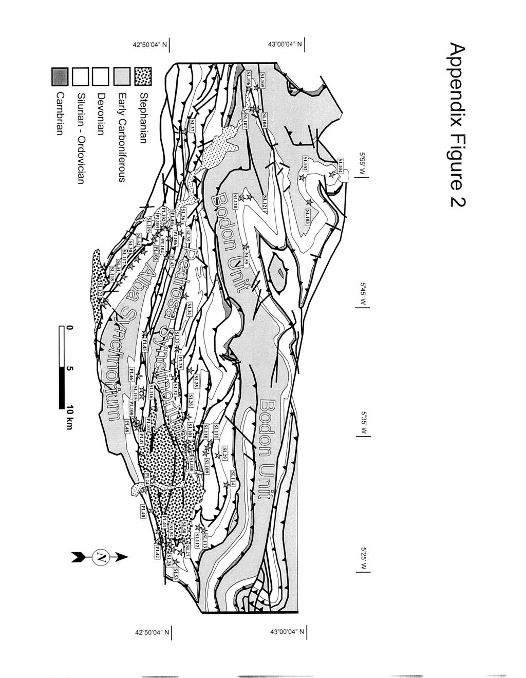
2 Weil et al., page 2 APPENDIX FIGURE CAPTIONS Figure Appendix 1. Typical examples of orthogonal thermal demagnetization plots (Zijderveld, 1967) in in situ coordinates from 9 Devonian limestone samples from Portilla and Santa Lucia Formations. Open (closed) symbols represent projections onto vertical (horizontal) plane; demagnetization temperatures given in degrees Celsius. A: Bodon unit. B: Pedrosa synclinorium. C: Northern limb of Alba synclinorium. D: Southern limb of Alba synclinorium. Figure Appendix 2. Schematic geologic map of southern arm of Cantabria-Asturias arc. Paleomagnetic site locations are shown as dark gray stars. REFERENCES Fisher, R. A., 1953, Dispersion on a sphere: Proceeds Royal Society of London A, v. 217, p Hoffman, K. A., and Day, R., 1978, Separation of multi-component NRM: A general method: Earth and Planetary Science Letters, v. 40, p Kirschvink, J. L., 1980, The least-squares line and plane and the analysis of paleomagnetic data: Royal Astronomical Society Geophysical Journal, v. 62, p McElhinny, M. W., 1964, Statistical significance of the fold test in paleomagnetism: Royal Astronomical Society Geophysical Journal, v. 8, p McFadden, P. L., Reid, A. B., 1982, Analysis of paleomagnetic inclination data: Royal Astronomical Society Geophysical Journal, v. 69, p Van der Voo, R., Stamatakos, J. A., and Pares, J. M., 1997, Kinematic constraints on thrust-belt curvature from syndeformational magnetizations in the Lagos del Valle Syncline in the Cantabrian Arc, Spain: Journal of Geophysical Research, v. 102, p. 10, , 120.
3 Weil et al., page 3 Weil, A.B. and Van der Voo, R., 2001, Insights into the mechanism for orogen related carbonate remagnetization from growth of authigenic Fe-oxide: A SEM and rock magnetic study of Devonian carbonates from northern: Journal of Geophysical Research (in press). Weil, A.B., Van der Voo, R., van der Pluijm, B. and Parés, J.M., 2000, The Formation of an orocline by multiphased deformation: a paleomagnetic investigation of the Cantabria-Asturias Arc Hinge-Zone (northern Spain): Journal of Structural Geology, v. 22, p Zijderveld, J. D. A., 1967, AC demagnetization of rocks: Analysis of results, in Collison, D. W., Runcorn, S. K., and Creer K. M., eds., Methods in Paleomagnetism: New York, Elsevier, p
4 Table 1: Paleomagnetic and structural site information and statistical parameters. Tectonic Corrections Uncorrected Site Mean Sites Strike OT Dip Dip Dec - Low Temp Dec - High Temp Inc - Low Temp α95 K Inc - High Temp α 95 K Bodon Unit SL SL SL SL SL SL SL SL SL SL (147-29) Pedrosa Synclinorium PL SL SL SL SL SL SL SL SL SL SL SL SL SL SL SL SL SL SL SL SL SL SL Alba Synclinorium Northern Limb PL PL PL PL42* PL43# PL44# PL45# PL46# PL47# PL PL
5 PL PL PL SL115* Sl116* Southern Limb PL PL PL SL SL31* SL SL SL118* SL SL122* Designates overturned bedding * Designates a site that could not be used (explained in text) # Designates a site that required Hoffman Day (1978) analysis. (Dec, Inc) Represents paleomagnetic data not used in analysis (explained in text)
6 Table 2: Summary of structurally corrected site information. Tectonic Corrections Structural Correction Axes Corrected Site Mean Sites Strike OT Dip Dip Trend Plunge Angle Dec Inc Bodon Unit SL SL SL SL SL SL SL SL SL Alba Synclinorium PL PL40L PL40H# PL PL43L PL43H# PL44L PL44H# PL45L PL45H# PL46L PL46H# PL47L PL47H# PL48 # PL PL PL PL Designates overturned bedding L, H - Designates the Low or High temperature component from a given site. # Designates a site that required two stages of structural correction (structural axes given as total combined rotation axes).
7
8
The formation of an orocline by multiphase deformation: a paleomagnetic investigation of the Cantabria±Asturias Arc (northern Spain)
") Journal of Structural Geology 22 (2000) 735±756 www.elsevier.nl/locate/jstrugeo The formation of an orocline by multiphase deformation: a paleomagnetic investigation of the Cantabria±Asturias Arc (northern
Journal of Structural Geology 22 (2000) 735±756 www.elsevier.nl/locate/jstrugeo The formation of an orocline by multiphase deformation: a paleomagnetic investigation of the Cantabria±Asturias Arc (northern
Is the Troodos ophiolite (Cyprus) a complete, transform. fault bounded Neotethyan ridge segment?
 a complete, transform. fault bounded Neotethyan ridge segment?") GSA Data Repository DR1 Is the Troodos ophiolite (Cyprus) a complete, transform fault bounded Neotethyan ridge segment? Antony Morris and Marco Maffione Data Repository methods 1.1. Paleomagnetic analysis
GSA Data Repository DR1 Is the Troodos ophiolite (Cyprus) a complete, transform fault bounded Neotethyan ridge segment? Antony Morris and Marco Maffione Data Repository methods 1.1. Paleomagnetic analysis
Clockwise rotation of the entire Oman ophiolite occurred in a suprasubduction zone setting Antony Morris et al.
 GSA Data Repository 216351 Clockwise rotation of the entire Oman ophiolite occurred in a suprasubduction zone setting Antony Morris et al. 1 2 3 4 5 6 7 8 9 1 11 12 13 14 15 16 17 18 19 2 21 22 23 24 25
Data Repository Item
 Data Repository Item 2002103 Supplementary Material for Sedimentologic-Magnetic Record of Western Pangean Climate in Upper Paleozoic Loessite (Lower Cutler Beds, Utah) G.S. (Lynn) Soreghan, R. Douglas
Stress and Strain. Stress is a force per unit area. Strain is a change in size or shape in response to stress
 Geologic Structures Geologic structures are dynamically-produced patterns or arrangements of rock or sediment that result from, and give information about, forces within the Earth Produced as rocks change
Chapter 15 Structures
 Chapter 15 Structures Plummer/McGeary/Carlson (c) The McGraw-Hill Companies, Inc. TECTONIC FORCES AT WORK Stress & Strain Stress Strain Compressive stress Shortening strain Tensional stress stretching
Syn-folding remagnetization of Cambro-Ordovician carbonates from the Pennsylvania Salient post-dates oroclinal rotation
 Tectonophysics 422 (2006) 41 54 www.elsevier.com/locate/tecto Syn-folding remagnetization of Cambro-Ordovician carbonates from the Pennsylvania Salient post-dates oroclinal rotation Donald P. Cederquist,
Lecture 6 Folds, Faults and Deformation Dr. Shwan Omar
 Fold: A fold is a bend or wrinkle of rock layers or foliation; folds form as a sequence of ductile deformation. Folding is the processes by which crustal forces deform an area of crust so that layers of
1. classic definition = study of deformed rocks in the upper crust
 Structural Geology I. Introduction 1. classic definition = study of deformed rocks in the upper crust deformed includes translation, rotation, and strain (change of shape) All rocks are deformed in some
Structural Geology and Geology Maps Lab
 Structural Geology and Geology Maps Lab Mesa College Geology 101 Lab Ray Rector: Instructor Structural Geology Lab Pre-Lab Resources Pre-Lab Internet Links 1) Fundamentals of Structural Geology 2) Visualizing
Interactive 3D Sketchupbook
 THE UNIVERSITY OF SYDNEY - SCHOOL OF GEOSCIENCES Interactive 3D Sketchupbook Patrice F. Rey CHAPTER 1 Orienting Planes and Lines 1 Interactive 1.1 Strike, dip and dip direction In a 3D space, planar surfaces
A. Refer to Appendix F in back of lab manual for list of commonly used geologic map symbols
 Structural Geology Lab 2: Outcrop Patterns and Structure Contours I. Geologic Map Symbols A. Refer to Appendix F in back of lab manual for list of commonly used geologic map symbols 1. Emphasis: a. strike
Name. GEOL.5220 Structural Geology Faults, Folds, Outcrop Patterns and Geologic Maps. I. Properties of Earth Materials
 I. Properties of Earth Materials GEOL.5220 Structural Geology Faults, Folds, Outcrop Patterns and Geologic Maps Name When rocks are subjected to differential stress the resulting build-up in strain can
Structural Geology Lab. The Objectives are to gain experience
 Geology 2 Structural Geology Lab The Objectives are to gain experience 1. Drawing cross sections from information given on geologic maps. 2. Recognizing folds and naming their parts on stereoscopic air
Structural Geology Lab. The Objectives are to gain experience
 Geology 2 Structural Geology Lab The Objectives are to gain experience 1. Drawing cross sections from information given on geologic maps. 2. Recognizing folds and naming their parts on stereoscopic air
Crustal Deformation Earth - Chapter Pearson Education, Inc.
 Crustal Deformation Earth - Chapter 10 Structural Geology Structural geologists study the architecture and processes responsible for deformation of Earth s crust. A working knowledge of rock structures
Lab 6: Plate tectonics, structural geology and geologic maps
 Geology 103 Name(s): Lab 6: Plate tectonics, structural geology and geologic maps Objective: To show the effects of plate tectonics on a large-scale set of rocks and to reconstruct the geological history
Crustal Deformation. Earth Systems 3209
 Crustal Deformation Earth Systems 3209 Crustal Deformation pg. 415 Refers to all changes in the original form and/or size of a rock body. May also produce changes in the location and orientation of rocks.
Palaeomagnetic Results from Lower Devonian Rocks of the Cheviot Hills, Northern England
 Geophys. J. R. astr. SOC. (1974) 36, 487-496. Palaeomagnetic Results from Lower Devonian Rocks of the Cheviot Hills, Northern England L. Thorning (Received 1973 March 26) Summary Palaeomagnetic work has
CRUSTAL DEFORMATION. Chapter 10
 CRUSTAL DEFORMATION and dgeologic Structures t Chapter 10 Deformation Df Deformation involves: Stress the amount of force applied to a given area. Types of Stress: Confining Stress stress applied equally
Dip-Sequence Analysis
 Chapter 9 Dip-Sequence Analysis 9.1 Introduction The three-dimensional geometry of a structure can be determined from the bedding attitudes measured in a single well bore or on a traverse through a structure.
UNIT 10 MOUNTAIN BUILDING AND EVOLUTION OF CONTINENTS
 UNIT 10 MOUNTAIN BUILDING AND EVOLUTION OF CONTINENTS ROCK DEFORMATION Tectonic forces exert different types of stress on rocks in different geologic environments. STRESS The first, called confining stress
Deformation of Rocks. Orientation of Deformed Rocks
 Deformation of Rocks Folds and faults are geologic structures caused by deformation. Structural geology is the study of the deformation of rocks and its effects. Fig. 7.1 Orientation of Deformed Rocks
Geologic Structures. Changes in the shape and/or orientation of rocks in response to applied stress
 Geologic Structures Changes in the shape and/or orientation of rocks in response to applied stress Figure 15.19 Can be as big as a breadbox Or much bigger than a breadbox Three basic types Fractures >>>
Lecture Outline Friday March 2 thru Wednesday March 7, 2018
 Lecture Outline Friday March 2 thru Wednesday March 7, 2018 Questions? Lecture Exam Friday March 9, 2018 Same time, Same room Bring Pencils and WSU ID 50 question Multiple Choice, Computer Graded Interlude
Provided by Tasa Graphic Arts, Inc. for An Introduction to Structural Methods DVD-ROM
 Provided by Tasa Graphic Arts, Inc. for An Introduction to Structural Methods DVD-ROM http://www.tasagraphicarts.com/progstruct.html AN INTRODUCTION TO STRUCTURAL METHODS - DETAILED CONTENTS: (Navigate
Lab 7: STRUCTURAL GEOLOGY FOLDS AND FAULTS
 Lab 7: STRUCTURAL GEOLOGY FOLDS AND FAULTS This set of labs will focus on the structures that result from deformation in earth s crust, namely folds and faults. By the end of these labs you should be able
Part I. PRELAB SECTION To be completed before labs starts:
 Student Name: Physical Geology 101 Laboratory #13 Structural Geology II Drawing and Analyzing Folds and Faults Grade: Introduction & Purpose: Structural geology is the study of how geologic rock units
Mountains are then built by deforming crust: Deformation & Mountain Building. Mountains form where stresses are high!
 Deformation & Mountain Building Where are mountains located? Deformation and Folding Mountain building Mountains form where stresses are high! Mountains form at all three types of plate boundaries where
Study the architecture and processes responsible for deformation of Earth s crust. Folding and Faulting
 Crustal Deformation AKA Structural geology (adapted from Brunkel, 2012) Study the architecture and processes responsible for deformation of Earth s crust. Folding and Faulting How Rocks Deform: 4 Controls
Answers: Internal Processes and Structures (Isostasy)
") Answers: Internal Processes and Structures (Isostasy) 1. Analyse the adjustment of the crust to changes in loads associated with volcanism, mountain building, erosion, and glaciation by using the concept
Answers: Internal Processes and Structures (Isostasy) 1. Analyse the adjustment of the crust to changes in loads associated with volcanism, mountain building, erosion, and glaciation by using the concept
GEOLOGIC MAPS PART II
 EARTH AND ENVIRONMENT THROUGH TIME LABORATORY - EES 1005 LABORATORY FIVE GEOLOGIC MAPS PART II Introduction Geologic maps of orogenic belts are much more complex than maps of the stable interior. Just
Arlo Brandon Weil Gabriel Gutiérrez-Alonso David Wicks
 DOI 10.1007/s00531-012-0790-3 ORIGINAL PAPER Investigating the kinematics of local thrust sheet rotation in the limb of an orocline: a paleomagnetic and structural analysis of the Esla tectonic unit, Cantabrian
Crustal Deformation. (Building Earth s Surface, Part 1) Science 330 Summer Mapping geologic structures
 Science 330 Summer Mapping geologic structures") Crustal Deformation (Building Earth s Surface, Part 1) Science 330 Summer 2005 Mapping geologic structures When conducting a study of a region, a geologist identifies and describes the dominant rock structures
Crustal Deformation (Building Earth s Surface, Part 1) Science 330 Summer 2005 Mapping geologic structures When conducting a study of a region, a geologist identifies and describes the dominant rock structures
Lecture Outlines PowerPoint. Chapter 10 Earth Science, 12e Tarbuck/Lutgens
 Lecture Outlines PowerPoint Chapter 10 Earth Science, 12e Tarbuck/Lutgens 2009 Pearson Prentice Hall This work is protected by United States copyright laws and is provided solely for the use of instructors
Structural Geology, GEOL 330 Fold mapping lab: Even folds get parasites Spring, 2012
 Structural Geology, GEOL 330 Name: Fold mapping lab: Even folds get parasites Spring, 2012 This exercise is meant to mimic a field experience in which you, the student, will measure beddingcleavage relationships
How mountains are made. We will talk about valleys (erosion and weathering later)
") How mountains are made We will talk about valleys (erosion and weathering later) http://www.ilike2learn.com/ilike2learn/mountainmaps/mountainranges.html Continent-continent plate convergence Less dense,
How mountains are made We will talk about valleys (erosion and weathering later) http://www.ilike2learn.com/ilike2learn/mountainmaps/mountainranges.html Continent-continent plate convergence Less dense,
Scholarship, Research, and Creative Work at Bryn Mawr College. Geology Faculty Research and Scholarship
 Bryn Mawr College Scholarship, Research, and Creative Work at Bryn Mawr College Geology Faculty Research and Scholarship Geology 22 Insights into the Mechanism for Orogen-Related Carbonate Remagnetization
How to Build a Mountain and other Geologic Structures. But first, questions
 How to Build a Mountain and other Geologic Structures But first, questions Questions your students might ask How were Montana s mountains formed? How old are the mountains? What are the different ways
Lectures in Paleomagnetism, 2005 by Lisa Tauxe. Citation:
 Lectures in Paleomagnetism, 2005 by Lisa Tauxe Citation: http://earthref.org/magic/books/tauxe/2005/ June 3, 2005 Tauxe, 2005 8-2 Lectures in Paleomagnetism Chapter 9 Getting a paleomagnetic direction
Early rotation and late folding in the Pennsylvania salient (U.S. Appalachians): Evidence from calcite-twinning analysis of Paleozoic carbonates
: Evidence from calcite-twinning analysis of Paleozoic carbonates") Early rotation and late folding in the Pennsylvania salient (U.S. Appalachians): Evidence from calcite-twinning analysis of Paleozoic carbonates Philip F. Ong Ben A. van der Pluijm Rob Van der Voo Department
Early rotation and late folding in the Pennsylvania salient (U.S. Appalachians): Evidence from calcite-twinning analysis of Paleozoic carbonates Philip F. Ong Ben A. van der Pluijm Rob Van der Voo Department
GCE AS/A level 1211/01 GEOLOGY GL1 Foundation Unit
 Surname Centre Number Candidate Number Other Names 2 GCE AS/A level 1211/01 GEOLOGY GL1 Foundation Unit S15-1211-01 A.M. MONDAY, 11 May 2015 1 hour For s use Question Maximum Mark 1. 15 2. 14 Mark Awarded
Essentials of Geology, 11e
 Essentials of Geology, 11e Crustal Deformation and Mountain Building Chapter 17 Instructor Jennifer Barson Spokane Falls Community College Geology 101 Stanley Hatfield Southwestern Illinois College Jennifer
Supplement of Frequency and intensity of palaeofloods at the interface of Atlantic and Mediterranean climate domains
 Supplement of Clim. Past, 12, 299 316, 2016 http://www.clim-past.net/12/299/2016/ doi:10.5194/cp-12-299-2016-supplement Author(s) 2016. CC Attribution 3.0 License. Supplement of Frequency and intensity
ESSENTIALS OF PALEOMAGNETISM
 ESSENTIALS OF PALEOMAGNETISM LISA TAUXE With Contributions from Robert F. Butler, R. Van der Voo, and Subir K. Banerjee CONTENTS PREFACE xiii 1 THE PHYSICS OF MAGNETISM 1 1.1 What is a magnetic field?
What Causes Rock to Deform?
 Crustal Deformation Earth, Chapter 10 Chapter 10 Crustal Deformation What Causes Rock to Deform? Deformation is a general term that refers to all changes in the shape or position of a rock body in response
Lecture 9 faults, folds and mountain building
 Lecture 9 faults, folds and mountain building Rock deformation Deformation = all changes in size, shape, orientation, or position of a rock mass Structural geology is the study of rock deformation Deformation
How to Build a Mountain and other Geologic Structures. But first a short review
 How to Build a Mountain and other Geologic Structures But first a short review Where do we see deep earthquakes? What is happening there? What can happen at a plate boundary? 1. Plates can move apart
Lecture 13: Tensors in paleomagnetism. What are tensors anyway? anisotropy of magnetic susceptibility (AMS) how to find it. what to do with it
 how to find it. what to do with it") Lecture 13: Tensors in paleomagnetism What are tensors anyway? anisotropy of magnetic susceptibility (AMS) how to find it what to do with it anisotropy of magnetic remanence 1 What is a tensor? An array
Lecture 13: Tensors in paleomagnetism What are tensors anyway? anisotropy of magnetic susceptibility (AMS) how to find it what to do with it anisotropy of magnetic remanence 1 What is a tensor? An array
PALEOMAGNETIC STABILITY
 Paleomagnetism: Chapter 5 8 PALEOMAGETIC TABILITY With the background information gained to this point, you appreciate the importance of isolating the characteristic RM by selective removal of the secondary
The fold test as an analytical tool
 Geophys. J. Int. (1998) 135, 329 338 The fold test as an analytical tool P. L. McFadden Australian Geological Survey Organization, GPO Box 378, Canberra, ACT 2601, Australia. E-mail: pmcfadde@agso.gov.au
Faults, folds and mountain building
 Faults, folds and mountain building Mountain belts Deformation Orogens (Oro = Greek all changes for mountain, in size, shape, genesis orientation, = Greek for or formation) position of a rock mass Structural
GEOL 220A Geologic Field Experiences: West Virginia Spring Term, 2008
 GEOL 220A Geologic Field Experiences: West Virginia Spring Term, 2008 Dr. Fred Soster Office: 216 Julian S&M e-mail: fsoster@depauw.edu Phone: 658-4670 Meeting Times: 2:15-3:15 p.m., Monday & Wednesday;
Lecture 9. Folds and Folding. Earth Structure (2 nd Edition), 2004 W.W. Norton & Co, New York Slide show by Ben van der Pluijm
, 2004 W.W. Norton & Co, New York Slide show by Ben van der Pluijm") Lecture 9 Folds and Folding Earth Structure (2 nd Edition), 2004 W.W. Norton & Co, New York Slide show by Ben van der Pluijm WW Norton; unless noted otherwise Fold Classification Maryland Appalachians
Lecture 9 Folds and Folding Earth Structure (2 nd Edition), 2004 W.W. Norton & Co, New York Slide show by Ben van der Pluijm WW Norton; unless noted otherwise Fold Classification Maryland Appalachians
Paleomagnetic dating of tectonically influenced Plio-Quaternary fan-system deposits from the Apennines (Italy)
") ANNALS OF GEOPHYSICS, 58, Fast Track 3, 2015 Paleomagnetic dating of tectonically influenced Plio-Quaternary fan-system deposits from the Apennines (Italy) Michele Saroli 1,2, Marco Moro 2, Fabio Florindo
ANNALS OF GEOPHYSICS, 58, Fast Track 3, 2015 Paleomagnetic dating of tectonically influenced Plio-Quaternary fan-system deposits from the Apennines (Italy) Michele Saroli 1,2, Marco Moro 2, Fabio Florindo
Folds in Appalachian Mts.
 Pelatnas IESO Geologi Struktur 2013 Deformasi Liat Salahuddin Husein Jurusan Teknik Geologi Fakultas Teknik Universitas Gadjah Mada 2013 1 Folds in Appalachian Mts. Folds in Myanmar, in the Indo-Burma
Tectonics is a study of the major structural features of the Earth s crust or a broad structure of a region. Tecto- means building
 TECTONICS AND TECTONIC STRUCTURES Tectonics is a study of the major structural features of the Earth s crust or a broad structure of a region. Tecto- means building The plate theory Different stages are
Theme 7. Metamorphic rocks. Distinguishing rock types
 Theme 7. Metamorphic rocks. Distinguishing rock types 7.1. Metamorphic rocks formation 7.2. Classification of metamorphic rocks 7.3. Distinguishing rock types 7.1. Metamorphic rocks formation 7.1. Metamorphic
FOLD CLASSIFICATIONS
 GG303 Lecture 28 9/4/01 1 FOLD CLASSIFICATIONS I Main Topics A Fold nomenclature B Ramsay's classification schemes C Interference of folds D Superposition of folds II Fold nomenclature and classification
Comparison of Microseismic Results in Complex Geologies Reveals the Effect of Local Stresses on Fracture Propagation
 Comparison of Microseismic Results in Complex Geologies Reveals the Effect of Local Stresses on Fracture Propagation Mike Preiksaitis, Sheri Bowman, Ted Urbancic ESG Canada Inc. Summary Understanding the
P. L. McFadden* and D. L. Jones DepartmdntofPhysics, University of Zimbabwe, PO Box MP 167, Mount Pleasant, Salisbury, Zimbabwe
 Geophys. J. R. astr. SOC. (1981) 67,53-58 The fold test in palaeomagnetism 1 Introduction P. L. McFadden* and D. L. Jones DepartmdntofPhysics, University of Zimbabwe, PO Box MP 167, Mount Pleasant, Salisbury,
The Magnetic Field of the Earth
 The Magnetic Field of the Earth Paleomagnetism, the Core, and the Deep Mantle RONALD T. MERRILL Department of Geophysics University of Washington Seattle, Washington MICHAEL W. McELHINNY Gondwana Consultants
L A N D F O R M S W E D N E S D A Y
 E P S C 2 4 0 : G E O L O G Y I N T H E F I E L D L A N D F O R M S W E D N E S D A Y Google Earth/Mars lab Laptops Install Google Earth Pro Île Sainte Hélène report due Return mineral ID kits (for non-mineralogy
Mine Scale Constrained Geophysical Inversion; A Case Study at the Darlot-Centenary Gold Mine
 Page 1 Mine Scale Constrained Geophysical Inversion; A Case Study at the Darlot-Centenary Gold Mine Sarah Monoury, SRK Consulting, Ben Jupp, SRK Consulting and Andrew Foley, Gold Fields This article was
LAB 1: ORIENTATION OF LINES AND PLANES
 LAB 1: ORIENTATION OF LINES AND PLANES Read the introductory section, chapter 1, pages 1-3, of the manual by Rowland et al (2007) and make sure you understand the concepts of bearing, strike, dip, trend,
KEY CHAPTER 12 TAKE-HOME QUIZ INTERNAL STRUCTURES AND PROCESSES Score Part B = / 55 PART B
 GEOLOGY 12 KEY CHAPTER 12 TAKE-HOME QUIZ INTERNAL STRUCTURES AND PROCESSES Score Part B = / 55 PART B CHAPTER 12 Isostacy and Structural Geology 1. Using the terms below, label the following diagrams and
Erroneous fold tests as an artifact of alteration chemical remanent magnetization
 JOURNAL OF GEOPHYSICAL RESEARCH, VOL. 107, NO. B12, 2369, doi:10.1029/2001jb000805, 2002 Erroneous fold tests as an artifact of alteration chemical remanent magnetization Karen Nørgaard Madsen and Harald
Germán Bayona a, *, William A. Thomas a, Rob Van der Voo b
 Journal of Structural Geology 25 (2003) 1193 1212 www.elsevier.com/locate/jsg Kinematics of thrust sheets within transverse zones: a structural and paleomagnetic investigation in the Appalachian thrust
What do variable magnetic fabrics in gabbros of the Oman ophiolite reveal about lower oceanic crustal magmatism at fast spreading ridges?
 GSA Data Repository 1998 1 2 3 4 5 6 7 8 9 11 12 13 14 15 16 17 18 19 21 22 23 24 25 26 27 28 29 3 31 32 33 34 35 36 37 38 39 4 41 42 43 44 45 46 47 48 49 5 51 52 What do variable magnetic fabrics in of
Rheological controls on the geometry of the Currawong VHMS Deposit, Lachlan Fold Belt, Victoria, SE Australia
 PACRIM 2015 Conference Paper Number: 16.00 Rheological controls on the geometry of the Currawong VHMS Deposit, Lachlan Fold Belt, Victoria, SE Australia T.G. Blenkinsop 1, D. Macklin 2 and R. Hammond 3
Deformation and Strain
 Deformation and Strain Processes in Structural Geology & Tectonics Ben van der Pluijm WW Norton+Authors, unless noted otherwise 2/13/2017 15:13 We Discuss Deformation and Strain Deformation Components
GSA Data Repository Item
 1 2 3 4 5 6 7 8 9 10 11 12 13 14 15 16 17 GSA Data Repository Item 2009221 Appendix A: Technical details of ASTER image of Lonar crater Multi-spectral Advanced Spaceborne Thermal Emission and Reflection
Structural Geology and Tectonics
 Fall 2015 Geology 4610 John Structural Geology and Tectonics GEOL 216/GEOL 318 The purpose of this course is to improve your understanding of deformation of the Earth's lithosphere. This introductory course
Geological Society of Nevada
 Geological Society of Nevada SOUTHERN NEVADA CHAPTER Newsletter March, 2001 PRESIDENT Chris Riechen Consultant VICE PRESIDENT Jean Cline UNLV Dept. of Geoscience TREASURER Paul Bowen Consultant SECRETARY
MAGMA FLOW DIRECTION OF THE SHIP ROCK RADIAL DIKE SWARM, NEW MEXICO
 MAGMA FLOW DIRECTION OF THE SHIP ROCK RADIAL DIKE SWARM, NEW MEXICO DENISE MARIE HARDMAN The College of Wooster Sponsor: Robert Varga ACKNOWLEDGEMENTS Field work on the Navajo Nation was conducted under
Strike-Slip Faults. ! Fault motion is parallel to the strike of the fault.
 Strike-Slip Faults! Fault motion is parallel to the strike of the fault.! Usually vertical, no hanging-wall/footwall blocks.! Classified by the relative sense of motion. " Right lateral opposite block
PALEOMAGNETIC DATA FROM THE BIG ISLAND GNEISS DOME AT KISSISSING LAKE (NTS 63N/3) by D.T.A Symons 1 and M.J. Harris 2 SUMMARY
 by D.T.A Symons 1 and M.J. Harris 2 SUMMARY") GS-5 PALEOMAGNETIC DATA FROM THE BIG ISLAND GNEISS DOME AT KISSISSING LAKE (NTS 63N/3) by D.T.A Symons 1 and M.J. Harris 2 Symons, D.T.A. and Harris, M.J. 1998: Paleomagnetic data from the Big Island gneiss
GS-5 PALEOMAGNETIC DATA FROM THE BIG ISLAND GNEISS DOME AT KISSISSING LAKE (NTS 63N/3) by D.T.A Symons 1 and M.J. Harris 2 Symons, D.T.A. and Harris, M.J. 1998: Paleomagnetic data from the Big Island gneiss
Course Title: Discipline: Geology Level: Basic-Intermediate Duration: 5 Days Instructor: Prof. Charles Kluth. About the course: Audience: Agenda:
 Course Title: Structural Geology Discipline: Geology Level: Basic-Intermediate Duration: 5 Days Instructor: Prof. Charles Kluth About the course: This course covers the basic ideas of structural geometry
19. A PALEOMAGNETIC EVALUATION OF THE AGE OF THE DOLOMITE FROM SITE 536, LEG 77, SOUTHEASTERN GULF OF MEXICO 1
 19. A PALEOMAGNETIC EVALUATION OF THE AGE OF THE DOLOMITE FROM SITE 536, LEG 77, SOUTHEASTERN GULF OF MEXICO 1 Margaret M. Testarmata, Institute for Geophysics, The University of Texas at Austin, Austin,
Answer sheet for question 1 Answer question 1 as soon as the sample arrives at your desk.
 EAS 233 Geologic structures. Final test. April 2012. 3 hours. Answer question 1 and 2 and three other questions. If you start more than the required number of questions, clearly delete the answers you
lecture 8 Methods of Structural Geology This lecture Mas Rabassers de Dalt (Spain) Mas Rabassers de Dalt (Spain)
 Mas Rabassers de Dalt (Spain)") This lecture Methods of Structural Geology lecture 8 Discuss the plotting exercise on Mas Rabassers de Dalt Look at folding related to shear zones Show an example of the application of new theory: Cap
This lecture Methods of Structural Geology lecture 8 Discuss the plotting exercise on Mas Rabassers de Dalt Look at folding related to shear zones Show an example of the application of new theory: Cap
Deformation: Modification of Rocks by Folding and Fracturing
 CHAPTER 7 Deformation: Modification of Rocks by Folding and Fracturing Chapter Summary A geologic map is a scientific model of rock formations that are exposed on the Earth s surface showing outcrops,
Structural Geology Laboratory.
 Structural Geology Wikipedia-Structural geology is the study of the threedimensional distribution of rock units with respect to their deformational histories. The primary goal of structural geology is
EAS 233 Geologic Structures and Maps Winter Miscellaneous practice map exercises. 1. Fault and separation:
 Miscellaneous practice map exercises 1. Fault and separation: With respect to Map 1, what are (a) the orientation of the fault, and (b) the orientation of bedding in the units cut by the fault. (c) Mark
Geology for Engineers Rock Mechanics and Deformation of Earth Materials
 89.325 Geology for Engineers Rock Mechanics and Deformation of Earth Materials Why do rocks break? Rock mechanics experiments a first order understanding. Faults and Fractures Triaxial load machine. a)
Rock mechanics as a significant supplement for cross-section balancing (an example from the Pavlov Hills, Outer Western Carpathians, Czech Republic)
") Trabajos de Geología, Universidad de Oviedo, 30 : 140-144 (2010) Rock mechanics as a significant supplement for cross-section balancing (an example from the Pavlov Hills, Outer Western Carpathians, Czech
Trabajos de Geología, Universidad de Oviedo, 30 : 140-144 (2010) Rock mechanics as a significant supplement for cross-section balancing (an example from the Pavlov Hills, Outer Western Carpathians, Czech
Global Tectonics. Kearey, Philip. Table of Contents ISBN-13: Historical perspective. 2. The interior of the Earth.
 Global Tectonics Kearey, Philip ISBN-13: 9781405107778 Table of Contents Preface. Acknowledgments. 1. Historical perspective. 1.1 Continental drift. 1.2 Sea floor spreading and the birth of plate tectonics.
Department of Geophysics Faculty of Earth Sciences King Abdulaziz University
 Department of Geophysics Faculty of Earth Sciences King Abdulaziz University Dr. Mansour A. Al-Garni Office: room 233/Buld. 27 OR Dept. chair office/buld. 55 Introduction to Geophysics EGP 211 Time: 10-10:55
A CROSS-SECTION the internal shape of folds. This is what you would see in a roadcut or a canyon wall. It is a view from the side.
 FOLDS Basic Fold Geometry A CROSS-SECTION the internal shape of folds. This is what you would see in a roadcut or a canyon wall. It is a view from the side. Closer to Earth s surface Deeper in Earth HINGE
Late orogenic, large-scale rotations in the Tien Shan and adjacent mobile belts in Kyrgyzstan and Kazakhstan
 Tectonophysics 426 (2006) 335 360 www.elsevier.com/locate/tecto Late orogenic, large-scale rotations in the Tien Shan and adjacent mobile belts in Kyrgyzstan and Kazakhstan Rob Van der Voo a,, Natalia
28. VRM STUDIES IN LEG 37 IGNEOUS ROCKS 1
 28. VRM STUDIES IN LEG 37 IGNEOUS ROCKS 1 D. V. Kent, Lamont-Doherty Geological Observatory, Columbia University, Palisades, New York and W. Lowrie, Institüt für Geophysik, ETH Hönggerberg, CH-8049 Zurich,
GY111 Earth Materials Practice Final Exam
 I. True/False Questions: circle a T for true or F for false (10% total -or- 0.5 per) 1. (T F) The Uranium used in nuclear power plants may explode if not controlled properly. 2. (T F) Natural Gas is an
35. MAGNETIZATION OF VARICOLORED PELAGIC LIMESTONES FROM HOLES 544A AND 547B 1. J. E. T. Channell, Department of Geology, University of Florida 2
 35. MAGNETIZATION OF VARICOLORED PELAGIC LIMESTONES FROM HOLES 544A AND 547B 1 J. E. T. Channell, Department of Geology, University of Florida 2 ABSTRACT Jurassic limestones from Holes 544A and 547B were
The Magnetic Field of the Earth. Paleomagnetism, the Core, and the Deep Mantle
 The Magnetic Field of the Earth Paleomagnetism, the Core, and the Deep Mantle This is Volume 63 in the INTERNATIONAL GEOPHYSICS SERIES A series of monographs and textbooks Edited by RENATA DMOWSKA and
Chapter 7 Plate Tectonics
 Chapter 7 Plate Tectonics Earthquakes Earthquake = vibration of the Earth produced by the rapid release of energy. Seismic Waves Focus = the place within the Earth where the rock breaks, producing an earthquake.
Evaluation of Structural Geology of Jabal Omar
 International Journal of Engineering Research and Development e-issn: 2278-067X, p-issn: 2278-800X, www.ijerd.com Volume 11, Issue 01 (January 2015), PP.67-72 Dafalla Siddig Dafalla * and Ibrahim Abdel
Structural Deformation and Karst in the Devonian Waterways Formation: Examples from Outcrops along the Athabasca River*
 Structural Deformation and Karst in the Devonian Waterways Formation: Examples from Outcrops along the Athabasca River* Chris L. Schneider 1 and Matthias Grobe 2 Search and Discovery Article #51073 (2015)
17. MAGNETOSTRATIGRAPHY OF EQUATORIAL PACIFIC SITE 503 HYDRAULIC PISTON CORES 1
 17. MAGNETOSTRATIGRAPHY OF EQUATORIAL PACIFIC SITE 503 HYDRAULIC PISTON CORES 1 Dennis V. Kent and Dann J. Spariosu, Lamont-Doherty Geological Observatory and Department of Geological Sciences, Columbia
Structural Analysis of Rocks and Regions 2017 Maps and cross-sections
 Structural Analysis of Rocks and Regions 2017 Maps and cross-sections The practicals in SARR will introduce you to (or remind you of) the tools and skills that are typically used to reconstruct and quantify
MESOSCOPIC STRUCTURES FROM THE AREA AROUND SATENGAL, LESSER GARHWAL HIMALAYA
 Journal of Scientific Research Vol. 55, 2011 : 25-34 Banaras Hindu University, Varanasi ISSN : 0447-9483 MESOSCOPIC STRUCTURES FROM THE AREA AROUND SATENGAL, LESSER GARHWAL HIMALAYA H. B. Srivastava, Lokesh