Earthquakes in Hawaii:
|
|
|
- Julius Reeves
- 6 years ago
- Views:
Transcription

1 Earthquakes in Hawaii: What you need to know U.S. Department of the Interior U.S. Geological Survey Prepared by: Janet L. Babb Hawaiian Volcano Observatory

2 Hawaii Standard Time The State of Hawaii experiences thousands of earthquakes every year. Most of these earthquakes are closely related to volcanic processes in Hawaii, and are so small they can be detected only by seismometers :00 12:00 More than 500 earthquakes were recorded by a nearby seismometer during the Kamoamoa fissure eruption along Kīlauea s East Rift Zone on March 6, : Minutes 30
3 Many earthquakes are strong enough to be felt on one or more islands. Locations of the 481 magnitude-3.0 and stronger earthquakes that were recorded during Color and size of dots reflect earthquake magnitude: M a g n i t u d e Source: USGS Hawaiian Volcano Observatory
4 Some earthquakes are large enough to cause damage and impact residents across the State of Hawaii. Since 1868, more than 30 magnitude-6.0 or greater earthquakes have rattled the islands. Source: USGS Fact Sheet (
5 Hawaii s most destructive earthquakes since 1868
 Location: Ka ū District, Island of Hawai i")

6 1868 April 2 Magnitude: Estimated at 7.9 (pre-dates the development of magnitude scales) Location: Ka ū District, Island of Hawai i Strong foreshocks including a magnitude-7.0 earthquake on March 28 and thousands of aftershocks shook the island for days. A dreadful night. Earthquake follows earthquake. We re all worn out. Diary of Annie Brown Spencer, Ka ū, Hawai i, March 29, 1868.

7 The April 2, 1868, earthquake was the largest in Hawaii s recorded history equivalent in size to the 1906 San Francisco earthquake in California. Wai ōhinu church in Ka ū, Hawai i, destroyed by the 1868 earthquake. Photo by H.L. Chase, courtesy of the Hawaiian Historical Society. Shaking: Extent: Damage: Extremely violent in south Hawai i (Maximum Intensity XII) Felt throughout the State of Hawaii Very heavy along Hawai i s south coast; moderate in Maui County This shaking and damage can be depicted on an earthquake intensity map.
8 Earthquake Intensity Map April 2, 1868 Using the Modified Mercalli Intensity Scale, colors on the map reflect the shaking and damage experienced by residents throughout the islands during the 1868 earthquake. M-7.9 Modified from: USGS Bulletin 2006 (
 high along the Ka ū-puna coast resulted in 46 deaths. triggered multiple landslides, including one in Ka ū s Wood Valley, where 31 people died.")
9 The April 2, 1868, earthquake destroyed houses, toppled stone walls, opened ground cracks, and threw people off their feet. killed at least 77 people. generated a tsunami. A wave up to 18 m (60 ft) high along the Ka ū-puna coast resulted in 46 deaths. triggered multiple landslides, including one in Ka ū s Wood Valley, where 31 people died. induced short-lived eruptions on Kīlauea and Mauna Loa. If this earthquake occurred today, damages could cost as much as: $ 500 million Source: Titus Coan, Scribner s Monthly, 1871 Source: PDC s Hawaii HAZUS Atlas
10 1871 February 19 Shaking: Very strong from East Maui to O ahu Extent: Felt throughout the State Damage: Extensive in Maui County some houses uninhabitable, stone walls and fences down, ground cracked open, rockfalls and landslides blocked roads and trails. Moderate damage on O ahu and minor damage on Hawai i. M-6.8 Modified from: USGS Bulletin 2006 (
 More than 6,200 foreshocks and aftershocks rattled the Hualālai area including a M-6.2 earthquake on September 25.")
11 1929 October 5 Shaking: Severe on Hualālai Extent: Felt as far away as O ahu Damage: Heavy in West Hawai i houses, water tanks, stone walls fences, and roadways damaged, some beyond repair. M-6.5 Modified from: USGS Bulletin 2006 ( More than 6,200 foreshocks and aftershocks rattled the Hualālai area including a M-6.2 earthquake on September 25. Fearing that their homes would collapse, some ranch residents camped out near Pu uwa awa a in West Hawai i. USGS photo.

12 1938 January 22 Shaking: Severe on Maui Extent: Felt throughout the State Damage: Heavy on north coast of Maui oil pipelines and water tanks burst, landslides blocked roads, stone walls collapsed, and ground cracks ruined roads. M-6.9 Minor damage from north Hawai i to Kaua i. Modified from: USGS Bulletin 2006 (


13 1951 August 21 Shaking: Severe in West Hawai i Extent: Distinctly felt as far away as O ahu Damage: Roads badly cracked and blocked by rock slides, electric and telephone service disrupted, and ~200 water tanks collapsed in central Kona District. Generated a small local tsunami, but no significant wave damage. M-6.9 Modified from: USGS Bulletin 2006 ( Collapsed water tank at Hōnaunau School in South Kona, Hawai i. USGS photo.

14 1973 April 26 Shaking: Severe in north Hawai i Extent: Felt on all islands Damage: Estimated at $5.75 million. East Hawai i declared a disaster area water and electric service disrupted; rockslides blocked roads; homes and businesses damaged. Injuries: At least 11 people injured in Hilo and Waimea. M-6.2 Modified from: USGS Bulletin 2006 ( Coastal damage on the Island of Hawai i. Photo by Larry Kadooka, Hawai i Tribune-Herald.


15 1975 November 29 Shaking: Severe in Puna District Extent: Felt across the State Damage: $4.1 million (including tsunami damage). Massive ground cracking and landslides damaged roads. Homes shifted off foundations. Structural and equipment damage at businesses. M-7.7 Modified from: USGS Bulletin 2006 ( Chain of Craters Road, Hawai i Volcanoes National Park. USGS photo. Impact on Hilo, Hawai i, supermarket. Photo by Larry Kadooka, Hawai i Tribune Herald. If this earthquake occurred today, damages could cost as much as: $ 500 million


16 The November 29, 1975, earthquake generated a devastating tsunami. At Halapē, two campers died and 19 others were injured when the tsunami swept over them. The coastline subsided by as much as 3.5 m (11 ft) during the earthquake, submerging Halapē s coconut grove in seawater. Red pack marks the extent of the tsunami inundation at Halapē. USGS photo. The tsunami with waves up to 14.6 m (48 ft) high caused extensive damage on the Island of Hawai i s south coast. A Punalu`u house demolished by the 1975 tsunami. Photo by David Shapiro, Honolulu Star-Bulletin.

17 1983 November 16 Shaking: Violent in Volcano area Extent: Felt as far away as Kauai Damage: Estimated at $7 million in Houses moved off foundations, roads heavily cracked and temporarily closed, water tanks and chimneys collapsed, landslides and severe ground failures occurred in many areas. Injuries: At least 6 people injured. M-6.6 Modified from USGS Bulletin 2006 ( Damage in the Hawaiian Volcano Observatory library. USGS photo. If this earthquake occurred today, damages could cost as much as: $ 200 million

 Collapsed home in Kalapana, Hawai i. USGS photo.")
18 1989 June 25 Shaking: Strong in southeast Puna District Extent: Felt as far away as O ahu Damage: Estimated at $1 million in Several homes collapsed; many others suffered significant structural damage. Generated a small local tsunami, but no wave damage was reported. M-6.1 Modified from: USGS Bulletin 2006 ( Collapsed home in Kalapana, Hawai i. USGS photo. If this earthquake occurred today, damages could cost as much as: $ 300 million

19 2006 October 15 Shaking: Strong to severe in North Kona and Kohala Districts Extent: Felt throughout the State Damage: Heavy damage to Kawaihae harbor, homes, hotels, roads, and bridges; extended power outage on O ahu; landslides blocked roads. M-6.0 M-6.7 Minutes after the M-6.7 Kīholo Bay earthquake, a M-6.0 earthquake struck offshore of Māhukona, Hawai i. A massive rockslide diverted the course of Honokāne Nui Stream in northeast Hawai i. USGS photo.


20 Examples of damage on the Island of Hawai i caused by the 2006 Kīholo Bay and Māhukona earthquakes. USGS photos. Highway 19, southeast of Kawāili Bridge. Kalāhikiola Congregational Church, Kapa au. Honoka a High School.
21 Bottom line Hawaii has a long history of destructive earthquakes. Hawaii s large earthquakes are equivalent in size to the strong earthquakes that occur along California s San Andreas fault. For example: 1906 San Francisco (M-7.9) 1989 Loma Prieta (M-6.9) 1994 Northridge (M-6.7)
22 The probability of a destructive magnitude-6.5 or higher earthquake striking the Hawaiian islands: in the next 10 years is 50%. in the next 20 years is 75%. in the next 50 years is 97%. Source: USGS Bulletin 2006 (


23 M-6.8 M M So It s not IF a destructive earthquake will strike Hawaii, but WHEN the next one will happen. M-6.2 M-7.7 M Modified from: USGS Bulletin 2006 (

24 Do you know how to protect yourself during Hawaii s next big earthquake?

25 To reduce injury (or worse) during an earthquake, take these actions: Source:

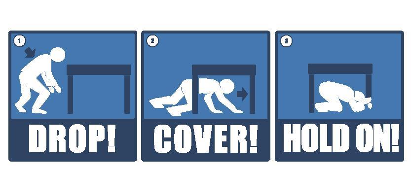
26 If you re inside a building, stay there, and DROP to the floor (before the earthquake drops you)! Take COVER under a sturdy table or desk! HOLD ON to your shelter and move with it until the shaking stops! Photo: Humboldt State University (
 above sea level, or beyond the marked tsunami hazard zone. Avoid steep cliffs and watch for falling rocks.")
27 If you re at or near the beach Drop! Cover! Hold on! until the strong shaking stops. Then quickly walk to higher ground or inland until you are at least 30 m (100 ft) above sea level, or beyond the marked tsunami hazard zone. Avoid steep cliffs and watch for falling rocks. Strong earthquakes in Hawaii have generated deadly tsunami, so moving to higher ground after the next big one could save your life.

28 For more information on what to do during an earthquake, including situations when you cannot get beneath a table, please see Recommended Earthquake Safety Actions in Hawaii


29 Practice makes perfect! You are encouraged to practice Drop! Cover! Hold on! during Held on the 3 rd Thursday in October 2015 October 15 at 10:15 a.m October 20 at 10:20 a.m October 19 at 10:19 a.m October 18 at 10:18 a.m October 17 at 10:17 a.m.


30 ShakeOut began in California in This earthquake drill is now global, with millions of people from around the world participating each year. Hawaii joined ShakeOut for the first time in Details about this year s Great Hawaii ShakeOut are posted at:

31 ShakeOut Resources Information on how to participate in the Great Hawaii ShakeOut and resources to help you know what to do during Hawaii s next earthquake are available online:
32 Summary: Large, destructive earthquakes have impacted the State of Hawaii in the past and will do so in the future. You must know how to protect yourself during an earthquake. Practice Drop! Cover! Hold on! so that you can react quickly during the next earthquake. The Great Hawaii ShakeOut is a good time to practice.


33 Please Annual drills: 2015 October 15 at 10:15 a.m October 20 at 10:20 a.m October 19 at 10:19 a.m October 18 at 10:18 a.m October 17 at 10:17 a.m. Annually 3 rd Thursday in October
34 Resources for more information about earthquakes in Hawaii

35 Recent Earthquakes in Hawaii The USGS Hawaiian Volcano Observatory monitors earthquakes across the State of Hawaii. Information and real-time data about recent events are posted on the HVO website:
36 Online resources: Hawaiian Volcano Observatory (HVO) Website Information about Hawaiian volcanoes and earthquakes, photographs and videos, Volcano Watch articles, news releases, and more. Earthquake pages include: Earthquakes Info on destructive earthquakes, seismicity, hazards, instrumentation, etc. Recent Earthquakes in Hawai i Real-time data on current earthquakes. November 29, 1975, Kalapana Earthquake Description of this magnitude-7.7 earthquake. Pacific Tsunami Warning Center Earthquake data and tsunami warning information.

37 Earthquakes in Hawai i An Underappreciated but Serious Hazard A USGS Fact Sheet about earthquake hazards and seismic monitoring in Hawaii. Selected Images of the Effects of the October 15, 2006, Kīholo Bay-Māhukona, Hawai i, Earthquakes and Recovery Efforts Almost 600 images from 36 sites on the Island of Hawai i, where damage was the most concentrated by the 2006 earthquakes. The Story of the Hawaiian Volcano Observatory A Remarkable First 100 Years of Tracking Eruptions and Earthquakes The story of HVO s founding in 1912, advances in monitoring tools and techniques, significant discoveries over the past century, and notable earthquakes and eruptions during HVO s first 100 years.
38 Volcano Watch articles about some of Hawaii s most destructive earthquakes: The Great Ka ū Earthquake of "Seismic crisis" in 1929 includes magnitude-6 earthquakes beneath Hualālai Keep Maui's 1938 earthquake in mind The 1951 Kealakekua Earthquake The 28th anniversary of a very damaging (1973 Honomū) earthquake 30th earthquake and accelerogram anniversary (of the 1973 Honomū earthquake) The Kalapana earthquake of Aftershocks continue six months after the (2006) Kīholo Bay Earthquake Progress in the year following the (2006) Kīholo Bay earthquake Continued rumblings of the 2006 Kīholo Bay Earthquake
39 USGS Earthquake Hazards Program Information about earthquakes around the world, including historic events in specific states. Hawaii Earthquake Information Frequently Asked Questions about Earthquakes USGS Earthquake Notification Service Sign up for a free service that sends you automated notifications when earthquakes happen. Did You Feel It? Feel an earthquake? Report what you experienced with a few clicks of your computer mouse. More info:

40
SCIENCE OF TSUNAMI HAZARDS
 SCIENCE OF TSUNAMI HAZARDS ISSN 8755-6839 Journal of Tsunami Society International Volume 29 Number 3 2010 POTENTIAL DEFICIENCIES IN EDUCATION, INSTRUMENTATION, AND WARNINGS FOR LOCALLY GENERATED TSUNAMIS
Location Option Details. 1. Florida
 1. Florida Florida has the smallest number of earthquaes in the United States. Florida is the U.S. location where hurricanes are most frequent. Of the six deadliest hurricanes to hit the continental U.S.,
Student task. Which factors affect the impact of a hazardous event?
 Student task Both volcanic eruptions and earthquakes often have a catastrophic impact and devastating effects. What similarities can you see in these three photographs? Lava slowly flowing over Chain of
How to Use This Presentation
 How to Use This Presentation To View the presentation as a slideshow with effects select View on the menu bar and click on Slide Show. To advance through the presentation, click the right-arrow key or
Tsunami waves swept away houses and cars in northern Japan and pushed ships aground.
 Japan was struck by a magnitude 8.9 earthquake off its northeastern coast Friday. This is one of the largest earthquakes that Japan has ever experienced. In downtown Tokyo, large buildings shook violently
Magnitude 7.0 N of ANCHORAGE, ALASKA
 A magnitude 7.0 earthquake occurred just before 8:30 am local time 8 miles north of Anchorage at a depth of 40.9 km (25.4 miles). There are reports of major infrastructure damage and damage to many homes
Natural Disasters. Why Are There Earthquakes? 197 words. The Power of the Earth 221 words. Big Waves! 188 words
 ARTICLE-A-DAY Natural Disasters 6 Articles Check articles you have read: Why Are There Earthquakes? 197 words The Power of the Earth 221 words Big Waves! 188 words The Volcano That Keeps Erupting 228 words
Natural Disasters Spring, LECTURE #8: Earthquake Disasters: Monitoring & Mitigation. Date: 1 Feb 2018 (lecturer: Dr.
 GEOL 0820 Ramsey Natural Disasters Spring, 2018 LECTURE #8: Earthquake Disasters: Monitoring & Mitigation Date: 1 Feb 2018 (lecturer: Dr. Shawn Wright) I. Exam I - Reminder Feb 6 th next class details:
VIDEO The 2011 Japanese Earthquake and Tsunami
 VIDEO The 2011 Japanese Earthquake and Tsunami Why was it so large and devastating? Why so short a warning? Why did tsunami precautions fail? What happened elsewhere? The Loma Prieta Earthquake (1989)
M 7.2 Earthquake along Iraq Iran border Sunday, November 12, Close to boundary of the Arabian and Eurasian Plates
 M 7.2 Earthquake along Iraq Iran border Sunday, November 12, 2017 Close to boundary of the Arabian and Eurasian Plates Length of Lava Flows Since the path of a lava flow is controlled by topography it
Magnitude 6.9 GULF OF CALIFORNIA
 A pair of strong earthquakes struck off the coast of Mexico early Thursday only minutes apart. The magnitude 6.9 and 6.2 were centered about 85 miles northeast of Guerrero Negro in the Mexican state of
Earthquakes Science & Safety. Dr. Richard Robertson Geologist & Head Seismic Research Unit
 Earthquakes Science & Safety Dr. Richard Robertson Geologist & Head Seismic Research Unit Summary The Eastern Caribbean islands are in a seismically active part of the world. Earthquake safety tips should
Magnitude 6.3 SOUTH ISLAND OF NEW ZEALAND
 A magnitude 6.3 earthquake shook the southern New Zealand city of Christchurch. At least 100 people are reported dead, and there are reports of collapsed buildings, cracked streets and flooding due to
Module 2, Investigation 1: Earthquake Hazards
 Module 2, Investigation 1: Earthquake Hazards Introduction Welcome! In the last module, you assumed the role of a volcanologist and learned how volcanoes are described and monitored. You will now assume
Earthquake Hazards. Tsunami
 Earthquake Hazards Tsunami Measuring Earthquakes Two measurements that describe the power or strength of an earthquake are: Intensity a measure of the degree of earthquake shaking at a given locale based
Supporting the response to the 2018 lower East Rift Zone and summit collapse at Kīlauea Volcano, Hawaiʻi
 Hawaiʻi Supersite success story Supporting the response to the 2018 lower East Rift Zone and summit collapse at Kīlauea Volcano, Hawaiʻi Since 1983, Kīlauea Volcano, on the Island of Hawaiʻi, has actively
Earthquakes Science & Safety. Ms Joan L. Latchman Seismologist Seismic Research Unit
 Earthquakes Science & Safety Ms Joan L. Latchman Seismologist Seismic Research Unit Summary Trinidad lies in an area of high earthquake activity for the Caribbean. Earthquake safety tips should be practiced
Magnitude 7.1 PHILIPPINES
 A magnitude 7.1 earthquake struck in the southeastern Philippines just after 8 am local time Tuesday morning killing 82 people and reducing a 17 th century church to rubble. Offices and schools were closed
2.3 Notes: Earthquake Damage Can Be Reduced
 2.3 Notes: Earthquake Damage Can Be Reduced Earthquakes can cause severe damage and loss of life Each year, there is about one earthquake with a magnitude of or higher-this is an extremely earthquake.
Magnitude 7.9 SE of KODIAK, ALASKA
 A magnitude 7.9 earthquake occurred at 12:31 am local time 181 miles southeast of Kodiak at a depth of 25 km (15.5 miles). There are no immediate reports of damage or fatalities. Light shaking from this
FOURTH GRADE HAZARDS 1 WEEK LESSON PLANS AND ACTIVITIES
 FOURTH GRADE HAZARDS 1 WEEK LESSON PLANS AND ACTIVITIES PLATE TECTONIC CYCLE OVERVIEW OF FOURTH GRADE VOLCANOES WEEK 1. PRE: Comparing different structures of volcanoes. LAB: Modeling three types of volcanoes.
Earthquakes. Earthquakes and Plate Tectonics. Earthquakes and Plate Tectonics. Chapter 6 Modern Earth Science. Modern Earth Science. Section 6.
 Earthquakes Chapter 6 Modern Earth Science Earthquakes and Plate Tectonics Section 6.1 Modern Earth Science Earthquakes and Plate Tectonics Earthquakes are the result of stresses in Earth s s lithosphere.
Earthquake Hazards. Tsunami
 Earthquake Hazards Tsunami Review: What is an earthquake? Earthquake is the vibration (shaking) and/or displacement of the ground produced by the sudden release of energy. The point inside the Earth where
Magnitude 7.1 NEAR THE EAST COAST OF HONSHU, JAPAN
 Japan was rattled by a strong aftershock and tsunami warning Thursday night nearly a month after a devastating earthquake and tsunami flattened the northeastern coast. This earthquake can be considered
Magnitude 7.1 PERU. There are early reports of homes and roads collapsed leaving one dead and several dozen injured.
 A magnitude 7.1 earthquake has occurred offshore Peru. The earthquake struck just after 4 a.m. local time and was centered near the coast of Peru, 40 km (25 miles) south-southwest of Acari, Peru at a depth
Earthquakes.
 Earthquakes http://thismodernworld.com/comic-archive Elastic rebound http://projects.crustal.ucsb.edu/understanding/elastic/rebound.html Elastic rebound Rocks store energy elastically When stored stress
Earthquake Hazards. Tsunami
 Earthquake Hazards Tsunami Review: What is an earthquake? Earthquake is the vibration (shaking) and/or displacement of the ground produced by the sudden release of energy. The point inside the Earth where
Deadly Earthquake Strikes Peru
 Deadly Earthquake Strikes Peru KEY POINTS On 14 January 2018, a magnitude-7.1 earthquake struck off the coast of Peru. At least two people have been reported dead, with dozens more left injured or homeless.
Chapter 4 Earthquakes and Tsunamis
 Geology of the Hawaiian Islands Class 21 30 March 2004 100 100 100 96 A B C D F Exam Scores 95 94 94 90 85 83 83 83 Mean 72 67 61 59 59 55 54 41 Mean = 78.5 Median = 83 Any Questions? Chapter 4 Earthquakes
Chapter 4 Earthquakes and Tsunamis. Geology of the Hawaiian Islands. Any Questions? Class March Mean = 78.
 Geology of the Hawaiian Islands Class 21 30 March 2004 Any Questions? 100 100 100 96 A B C D F Exam Scores 95 94 94 90 85 83 83 83 Mean 72 67 61 59 59 55 54 41 Mean = 78.5 Median = 83 Chapter 4 Earthquakes
Quake in Indonesia. A series of earthquakes strike the island nation.
 Quake in Indonesia A series of earthquakes strike the island nation. A series of earthquakes rocked the Indonesian island of Sumatra in Southeast Asia. On March 6, 2007, a 6.3-magnitude 1 quake destroyed
Name: KEY California Geology. Unit IX Earthquakes
 Unit IX Earthquakes Name: KEY California Geology The following assignment is based on information presented in Unit IX. Be sure to read the paragraphs (Note 1) provided before you attempt to answer the
Seismic Waves. 1. Seismic Deformation
 Types of Waves 1. Seismic Deformation Seismic Waves When an earthquake fault ruptures, it causes two types of deformation: static; and dynamic. Static deformation is the permanent displacement of the ground
Identifying the causes and effects of earthquakes
 Science 3 Physical Earth and Space Life LESSON 57 Identifying the causes and effects of earthquakes Lesson Preparation Program Materials Child s Booklet E Exploring the Earth s Structure (pp. 12 13) Optional:
What Are Disasters? The Rescue Kids Trio!
 The Rescue Kids Trio! What Are Disasters? This manual was made possible through funding by the Council of Local Authorities for International Relations. Disasters and emergency preparedness Emergency preparedness
Before exploring the effects of the 1906 earthquake, watch the video on ground shaking and liquefaction at:
 Seismic Risk: Pre- Work Paper Maps Version Early on the morning of April 16, 1906, a magnitude 7.8 earthquake struck on the San Andreas Fault. The 1906 San Francisco earthquake revolutionized our understanding
Lecture Outline Wednesday-Monday April 18 23, 2018
 Lecture Outline Wednesday-Monday April 18 23, 2018 Questions? Lecture Final Exam Lecture Section 1 Friday May 4, 8:00-10:00am Lecture Section 2 Friday May 4, 3:10-5:10 pm Final Exam is 70% new material
Hot lava "firehose" is pouring into ocean in Hawaii
 Hot lava "firehose" is pouring into ocean in Hawaii By Associated Press, adapted by Newsela staff on 02.08.17 Word Count 714 TOP: A January 29, 2017, photo provided by the U.S. Geological Survey shows
Magnitude 7.6 SOUTH OF IQUIQUE, CHILE
 A powerful aftershock struck off northern Chile prompting an evacuation of the coastal area and raising fears of a tsunami. This magnitude 7.6 earthquake is the largest of a series of aftershocks following
Earthquakes. Copyright 2006 InstructorWeb
 Earthquakes Earthquakes cause the earth to shake! Earthquakes are caused by a fault line under the earth's crust. You do not have to be right under a fault line to feel an earthquake. You could be miles
Magnitude 6.5 OFFSHORE NORTHERN CALIFORNIA
 A powerful offshore earthquake that struck near the Northern California coast left a hodgepodge of debris for communities to sort through Sunday but spared residents any serious injury. After 25,000 people
Scientists: Explosive eruption risk rises for Hawaii volcano 10 May 2018, by Sophia Yan And Audrey Mcavoy
 Scientists: Explosive eruption risk rises for Hawaii volcano 10 May 2018, by Sophia Yan And Audrey Mcavoy Hawaii Gov. David Ige said a geothermal energy plant near the lava outbreak was accelerating its
The map below shows the locations of earthquakes and volcanoes
 45 Understanding Plate Boundaries R E A D I N G The map below shows the locations of earthquakes and volcanoes on the earth s surface. Today, many of the world s most active volcanoes are located around
What is plate tectonics?
 What is plate tectonics? The Earth is made up of four layers: inner core, outer core, mantle and crust (the outermost layer where we are!). The Earth s crust is made up of oceanic crust and continental
Earthquakes and Earth s Chapter. Interior
 Earthquakes and Earth s Chapter Interior 8.1 What Is an Earthquake? An earthquake is the vibration of Earth produced by the rapid release of energy Focus and Epicenter Focus is the point within Earth
Magnitude 7.5 NEW BRITAIN REGION, PAPUA NEW GUINEA
 A magnitude 7.5 earthquake struck off the eastern coast of Papua New Guinea on Tuesday, approximately 130 km (81 mi) southsouthwest of Kokopo at a depth of 42 km (26.1 mi). There are reports of some structural
20.1 Earthquakes. Chapter 20 EARTHQUAKES AND VOLCANOES. Earthquakes and plate boundaries 500 UNIT 6 EARTH S STRUCTURE
 Chapter 20 EARTHQUAKES AND VOLCANOES 20.1 Earthquakes In Chapter 19, you read about the San Andreas Fault, which lies along the California coast (Figure 20.1). This fault passes right through San Francisco
Kīlauea Volcano: Be a Volcanologist. Image Credit: Julien Millet / Unsplash. Final Project
 The Kīlauea Volcano: Be a Volcanologist Image Credit: Julien Millet / Unsplash Final Project Final Project The Kīlauea Volcano: Be a Volcanologist In this two-day project, students apply their previous
Earthquakes An introduction to earthquake monitoring techniques
 Earthquakes An introduction to earthquake monitoring techniques TEACHER S COPY Aims To understand what an earthquake is and where they occur To gain an insight into how earthquakes are recorded and how
Magnitude 7.7 QUEEN CHARLOTTE ISLANDS REGION
 A major 7.7 magnitude earthquake struck at 8:04 PM local time in western British Columbia, Canada. The epicenter is located on Moresby Island, the southern large island in the Queen Charlotte Islands region.
Thursday, May 17, :30 a.m. EDT
 Thursday, May 17, 2018 8:30 a.m. EDT Significant Activity May 16-17 Significant Events: Kīlauea Volcano eruption Tropical Activity: Western Pacific no activity affecting U.S. interests Significant Weather:
Hazards in the Seattle Area. Disaster Questions. Where Were You? Where Were You? Volcanoes St. Helens Adams, Rainier, Glacier, Baker
 Hazards in the Seattle Area Volcanoes St. Helens Adams, Rainier, Glacier, Baker Earthquakes Outer coast Puget Sound (Seattle Fault & others) Tsunami Outer coast Puget Sound (Seattle Fault & others) Disaster
Earthquakes. Beyond the Book. FOCUS Book
 FOCUS Book Model how liquefaction during an earthquake changes Earth s surface and affects buildings. Put sand in a large plastic container. Mix enough water into the sand to make the ground feel firm.
7.3 Magnitude Earthquake Strikes Iran-Iraq Border
 7.3 Magnitude Earthquake Strikes Iran-Iraq Border KEY POINTS A magnitude 7.3 earthquake has struck the Iran-Iraq border with at least 348 fatalities reported. Thousands more have been injured and many
ACADEMIC YEAR SOCIAL STUDIES YR 9 CONCEPT REVIEW NOTES UNIT 2 : EARTHQUAKES & VOLCANOES What are volcanoes and earthquakes like?
 ACADEMIC YEAR 2016-2017 SOCIAL STUDIES YR 9 CONCEPT REVIEW NOTES UNIT 2 : EARTHQUAKES & VOLCANOES What are volcanoes and earthquakes like? Pages 26-27 1) What are you going to learn about in this unit?
Three Fs of earthquakes: forces, faults, and friction. Slow accumulation and rapid release of elastic energy.
 Earthquake Machine Stick-slip: Elastic Rebound Theory Jerky motions on faults produce EQs Three Fs of earthquakes: forces, faults, and friction. Slow accumulation and rapid release of elastic energy. Three
Tsunami! Beyond the Book. FOCUS Book
 FOCUS Book Use the engineering design process to design a structure that will protect a coastal town from possible tsunami damage. Brainstorm design ideas for your structure with a group of classmates.
The L.A. Earthquake Sourcebook
 The L.A. Earthquake Sourcebook If searched for the ebook The L.A. Earthquake Sourcebook in pdf format, then you have come on to the faithful website. We furnish complete option of this ebook in doc, DjVu,
4/10/18. Kaua i: probably the most complicated and leastunderstood of the major Hawaiian islands. Today s plan. What are the effects, if modeled?
 4// Kaua i: probably the most complicated and leastunderstood of the major Hawaiian islands Today s plan Some more landslides Kauai, part today What are the effects, if modeled? Model as sliding block
Multi-Jurisdictional Hazard Mitigation Plan. Table C.10 The Richter Scale. Descriptor Richter Magnitude Earthquake Effects
 Geologic Hazards Earthquake Earthquakes are very rare in Pennsylvania and have caused little damage, with no reported injuries or causalities. Earthquakes that do occur in Pennsylvania happen deep within
What is an earthquake?
 What is an earthquake? Shaking or vibration of the ground rocks undergoing deformation break suddenly along a fault 1906 San Francisco earthquake Oblique view of the San Andreas fault and San Francisco
Released Science Inquiry Task Location Grade 11
 Date: Your Name: Released Science Inquiry Task Location 2009 Grade 11 Science Directions: You will be completing an extended-response inquiry task called Location. Explain the reasons for all of your answers.
#13 Earthquake Prediction
 #13 Earthquake Prediction Obvious importance Earthquake Prediction Save lives, reduce damage Earthquake Prediction - Types Long-range prediction - involves EQ probability over long time period (years to
Magnitude 7.0 NEW CALEDONIA
 A magnitude 7.0 earthquake has occurred 82km ENE of Maré Island, the secondlargest of the Loyalty Islands in the archipelago of New Caledonia. The initial report of the magnitude and shallow 10km depth
Important Concepts. Earthquake hazards can be categorized as:
 Lecture 1 Page 1 Important Concepts Monday, August 17, 2009 1:05 PM Earthquake Engineering is a branch of Civil Engineering that requires expertise in geology, seismology, civil engineering and risk assessment.
Hurricane Lane. Hawaiian Islands, August By Ian Robertson 1, Ph.D., P.E.
 Hurricane Lane Hawaiian Islands, August 2018 By Ian Robertson 1, Ph.D., P.E. Hurricane Lane, a major Pacific Ocean hurricane, narrowly missed making landfall on the main Hawaiian Islands, but still caused
Earthquakes. These icons indicate that teacher s notes or useful web addresses are available in the Notes Page.
 Earthquakes These icons indicate that teacher s notes or useful web addresses are available in the Notes Page. This icon indicates the slide contains activities created in Flash. These activities are not
Magnitude 7.2 OAXACA, MEXICO
 A magnitude 7.2 earthquake has occurred in Oaxaca, Mexico at a depth of 24.6 km (15 miles). It was felt as far away as Guatemala. There have been no reported deaths directly linked to the earthquake. Emergency
Magnitude 7.5 PALU, INDONESIA
 A magnitude 7.5 earthquake occurred 80.8 km (50.2 mi) north of Palu, Indonesia at a depth of 10 km (6.2 miles). This earthquake triggered a tsunami with wave heights up to 2 m (6.6 ft) that an official
Processes and Impact of Natural Hazards
 The Big Island of Hawaii is the largest of the Hawaiian Islands. It is also home to a very active volcano. The Kilauea volcano has been active since 1983. The lava that flows from the Kilauea volcano has
Debris Avalanches. Debris avalanche deposits on a volcano in Chile. All of the area in the foreground is buried by a thick debris avalanche.
 Debris Avalanches Volcanoes are not very stable structures. From time to time, they collapse producing large rock and ash avalanches that travel at high speeds down valleys. Collapse maybe caused by an
State Of Wisconsin. Department of Military Affairs. Division of Emergency Management
 State Of Wisconsin Department of Military Affairs Division of Emergency Management Brian M. Satula Administrator Scott Walker Governor For more information contact: Tod Pritchard Office: 608-242-3324 Cell:
Mw 7.8, Southwest of Sumatra, Indonesia Wed, 2 March 2016 at 12:49:48 UTC M /03/03
 Earthquake overview AFGHANISTA N PAKISTA N INDIA A moment magnitude (Mw) 7.8 earthquake struck in South West, Indonesia. The epicentre was centered about 800 km West South West of Padang, Sumatra province,
Mount Pinatubo and the Ring of Fire
 Mount Pinatubo and the Ring of Fire Mount Pinatubo and the Ring of Fire On July 16, 1990, a large earthquake struck Luzon, an island in the Philippines. The earthquake devastated cities for hundreds of
How to communicate Cascadia Subduction Zone earthquake hazards
 How to communicate Cascadia Subduction Zone earthquake hazards Tom Brocher Research Geophysicist Earthquake Science Center U.S. Geological Survey Menlo Park, California Seattle Post-Intelligencer Lessons
11/30/16 EARTHQUAKES ELASTIC LIMIT FAULT FORCE AND PLATES WHAT DO YOU NOTICE?
 ELASTIC LIMIT EARTHQUAKES Bend sitck but do not break it. What do you notice? No bend until it breaks. Describe the energy and forces at work. (Kinetic, potential etc) 8 TH GRADE FAULT FORCE AND PLATES
The Richter Scale. Micro Less than 2.0 Microearthquakes, not felt. About 8,000/day
 Geologic Hazards General s are very rare in Pennsylvania and have caused very little damage and no reported injuries or casualties. Since the Commonwealth is not on an active fault, the earthquakes that
Magnitude 7.5 PAPUA NEW GUINEA
 A magnitude 7.5 earthquake occurred 33 kilometers (20 miles) southwest of Tari, Papua New Guinea, at a depth of 35 km (22 miles). Papua New Guinea is located on the eastern half of the island of New Guinea,
SHAKE, RATTLE, AND ROLL INVESTIGATING EARTHQUAKES
 NAME DATE PARTNER(S) SHAKE, RATTLE, AND ROLL INVESTIGATING EARTHQUAKES The city of San Francisco was destroyed by a 7.8 magnitude earthquake that ruptured gas lines and set the city ablaze. March 28, 1964
An entire branch of Earth science, called, is devoted to the study of earthquakes.
 Lesson One Essential Question Where do earthquakes take place? What causes earthquakes? What are three different types of faults that occur at plate boundaries? How does energy from earthquakes travels
REVIEW: The Setting - Climatology of the Hawaiian Archipelago
 REVIEW: The Setting - Climatology of the Hawaiian Archipelago Atmosphere and Ocean 5 facts: NE trade-winds tropical water subtropical gyre Seasonality N S gradients Four dominant swell regimes: north Pacific
1 of 27. Boardworks Ltd Earthquakes
 1 of 27 Earthquakes Teacher s notes and Flash files Most slides contain notes to accompany the presentation. This icon indicates that the notes contain particularly detailed instructions or extension activities.
Magnitude 7.5 NEW BRITAIN REGION, PAPUA NEW GUINEA
 A magnitude 7.5 earthquake struck off the eastern coast of Papua New Guinea on Sunday, approximately 54 km (33 miles) southeast of Kokopo. Residents reported strong ground shaking for about five minutes.
Collision and transform Boundaries
 Collision and transform Boundaries I. The collision boundary Sometimes when two plates move together they are both continental rather than one being continental and one being oceanic as at the destructive
Also, when Cascade volcanoes do erupt, high-speed avalanches of pyroclastic flows
 INTRODUCTION A volcano is a vent through which molten rock escapes to the Earth s surface. Unlike other mountains, which are pushed up from below, volcanoes are built by surface accumulation of their eruptive
Geologic Hazards. Montour County Multi-jurisdictional. General. Earthquake
 Geologic Hazards General s are very rare in Pennsylvania and have caused little damage with no reported injuries or causalities. s that do occur in Pennsylvania happen deep within the Earth s crust. This
2013 Tornado and Severe Weather Awareness Drill
 2013 Tornado and Severe Weather Awareness Drill Scheduled for Thursday April 18, 2013 The 2013 Tornado Drill will consist of a mock tornado watch and a mock tornado warning for all of Wisconsin. This is
What is an Earthquake?
 Earthquakes What is an Earthquake? Earthquake - sometimes violent shaking of ground caused by movement of Earth s tectonic plates; creates seismic waves Often followed by smaller earthquakes (aftershocks);
Lesson 8. Natural Disasters
 Lesson 8 Natural Disasters 1 Reading is NOT a spectator sport! 2 Reading requires active participation! 3 PREDICT Try to figure out what information will come next and how the selection might end. 4 Natural
Magnitude 8.2 NORTHWEST OF IQUIQUE, CHILE
 An 8.2-magnitude earthquake struck off the coast of northern Chile, generating a local tsunami. The USGS reported the earthquake was centered 95 km (59 miles) northwest of Iquique at a depth of 20.1km
Volcanoes. Introduction
 Volcanoes Introduction Display Slide V-0 Explain that a volcano is a vent through which molten rock escapes to the Earth s surface. Unlike other mountains, which are pushed up from below, volcanoes are
Unit 9 (packet #2): Volcanoes and Earthquakes
: Volcanoes and Earthquakes") Unit 9 (packet #2): Volcanoes and Earthquakes 13. Earthquakes are one of the most destructive natural forces. I can a. Explain what an earthquake is, where they occur and why they occur. b. Describe the
Unit 9 (packet #2): Volcanoes and Earthquakes 13. Earthquakes are one of the most destructive natural forces. I can a. Explain what an earthquake is, where they occur and why they occur. b. Describe the
Dynamic Crust Regents Review
 Name Dynamic Crust Regents Review Base your answers to questions 1 through 3 on the table below, which lists the location of some earthquakes, their Richter magnitude, and their year of occurrence. Data
Cyber Enabled Earth Exploration (CE )
") Cyber Enabled Earth Exploration 3 (CE ) Field Notebook Module 2: Introduction to Earthquakes Investigation 1: Earthquake Hazards Table of Contents Folder 1: Describing Earthquakes... 3 Folder 2: Shaanxi,
Cyber Enabled Earth Exploration 3 (CE ) Field Notebook Module 2: Introduction to Earthquakes Investigation 1: Earthquake Hazards Table of Contents Folder 1: Describing Earthquakes... 3 Folder 2: Shaanxi,
What is a tsunami? Capital Regional District Tsunami Frequently Asked Questions (FAQ s) Tsunami (soo-nah-mee)
 Tsunami (soo-nah-mee)") Tsunami (soo-nah-mee) Tsunamis (Japanese translation harbour wave ) are waves with a great distance between crests, and are caused by any widespread, sudden movement of large volumes of water. The tsunami
Tsunami (soo-nah-mee) Tsunamis (Japanese translation harbour wave ) are waves with a great distance between crests, and are caused by any widespread, sudden movement of large volumes of water. The tsunami
Plate Tectonics IDEA THAT EARTH S SURFACE IS BROKEN INTO PLATES THAT MOVE AROUND. Fault = fracture in the crust where the movement has occurred
 Warm-up #14 A mountain range found 100 meters above sea level is measured to be 1,000 meters high from its tallest peak. From the top, the first 500 meters are incredibly steep. After this point, the mountain
Plates & Boundaries The earth's continents are constantly moving due to the motions of the tectonic plates.
 Plates & Boundaries The earth's continents are constantly moving due to the motions of the tectonic plates. As you can see, some of the plates contain continents and others are mostly under the ocean.
FINAL EXAM December 20 th, here at 1:00 3:00 pm
 FINAL EXAM December 20 th, here at 1:00 3:00 pm REVIEW SESSION December 11 th at 6:00-7:30 pm Morrill I Auditorium (Room N375) Same as last time Don t forget your online course evaluations! Major Volcanic
Magnitude 7.0 PERU. This region of the Andes is a sparsely populated area, there were no immediate reports of injuries or damage.
 A magnitude 7.0 earthquake occurred in southeastern Peru on Friday about 27 kilometers northeast of the town of Azángaro, Peru, near the border with Bolivia. The earthquake occurred at a depth of 257.4
Tornadoes pose a high risk because the low atmospheric pressure, combined with high wind velocity, can:
 Tornadoes are powerful, circular windstorms that may be accompanied by winds in excess of 200 miles per hour. Tornadoes typically develop during severe thunderstorms and may range in width from several