4/10/18. Kaua i: probably the most complicated and leastunderstood of the major Hawaiian islands. Today s plan. What are the effects, if modeled?
|
|
|
- Ferdinand Carson
- 5 years ago
- Views:
Transcription


 Landslide")
1 4// Kaua i: probably the most complicated and leastunderstood of the major Hawaiian islands Today s plan Some more landslides Kauai, part today What are the effects, if modeled? Model as sliding block within the area mapped Ward SN () Landslide Tsunami J Geophys Res 6:
 Landslide Tsunami J Geophys Res 6: The")
 Cumbre Vieja")
 One of the")

2 4// Tsunami moving across the ocean Predicts large waves here and across the Pacific Ward SN () Landslide Tsunami J Geophys Res 6: The popular case more potential damage Kilauea is moving like a slump, Canary Islands seem ready to slide Ward SN, Day S () Cumbre Vieja Volcano Potential collapse and tsunami at La Palma, Canary Islands Geophys Res Lett :74 La Palma, Canaries Ward & Day () One of the steepest slopes among volcanic islands South rift already shows cracks Hyaloclastites known to exist deep down


3 4// Supposed problem for the East coast Note runup = how far water pushes up on land, not wave height in open ocean what would this do to NE USA? Supposed problem for the East coast Again large waves locally, and across the ocean s of meters would ruin a lot along the E coastline However Not based on real science: Slide/slump not a single event Waves decrease in size much faster


 Diagram by")
4 4// Kalalau Valley Nā Pali coast Olokele plateau Līhu e Basin Mānā plain Waimea Canyon Old model of volcanic structure i pal Na Olokele Olokele caldera defined by: faults, thick flat lavas Waimea canyon Þ Napali = shield, Olokele fills the crater in the shield volcano But gravity suggests crater in Līhu e Basin, not Olokele Plateau (grey) Makes sense in the broader gravity picture Diagram by Flinders et al () Diagram by Krivoy et al (6) 4


5 4// Kauai, Hawaii With the gravity maximum there, what is the Lihue Basin? secondary caldera? Landslide scar? Preferentially eroded volcano center? Kalalau Valley Nā Pali coast Olokele plateau Mānā plain Līhu e Basin Three sequences in Waimea Canyon Waimea Canyon Sherrod et al, 7; USGS Ages Napali is oldest, Olokele is next, Makaweli seems last shield All followed by rejuvenated Koloa, though there seems to be some overlap Waimea Canyon Basalt Koloa Volcanics


6 4// Volcanic stages Volcano HAWAIIAN ISLANDS STAGES AND AGES Volcanic Stage Shield Kīlauea Mauna Loa Hualālai Mauna Kea Kohala E Maui Puna Pāhala Ash Hilina Ka u Kahuku Nīnole Hualālai Hamākua Pololū Honomanū? PostShield Cap ~ 4 + 4? A D L 7 a u p ā h o Kaua i Ni ihau Wailuku L Member Lāna i L Member Ko olau Kamaile unu Lualualei Makaweli Olokele Haupu Napali Paniau 6?? e h o e? 4 Hawī 6 6 K u l a H W Maui Kaho olawe Lāna i E Moloka i W Moloka i Ko olau Wai anae Rejuvenation ā n a Honolua U Member ~ ~ Lahaina 6 U Member Kalaupapa ~ Honolulu 6? Koloa 6 ~ Ki eki e Kolekole Pālehua 6 Not every volcano has every stage Some volcanoes skip a stage Some volcanoes die young Names with ages listed under stages are the names of mapped geological units Submarine structures Lots of reflective seafloor material around Kaua i means? GLORIA sonar backscatter data Connection Lihue topography and submarine bathymetry: landslide! The twovolcano model of Holcomb et al [7] different models shown; only volcanosolutions can explain that W vs E flanks are compositionally distinct W E 6

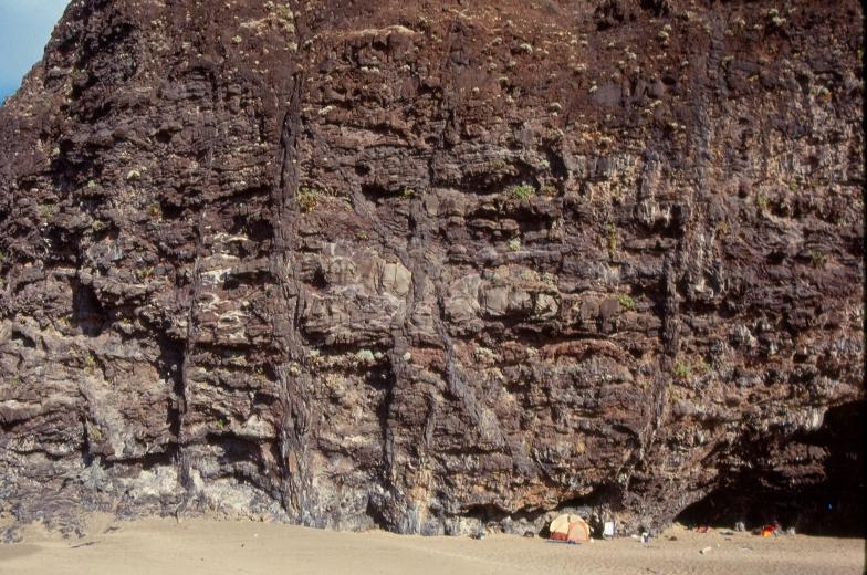
7 4// An excellent illustration of the volcano scenario for the development of Kaua i (see book) Collapse of existing volcano leads to build up of lava against old cliff Erosion particularly affects the E side; windward side, landslide? Ponded flatlying lavas remain up top Avalanche scarp N flank of younger volcano wavecut cliff West flank of older volcano lavas ponded between avalanche scar and W flank of younger volcano preferrentially eroded central part of younger volcano old wavecut cliff SW flank of younger volcano Waimea Canyon (diverted wflowing streams off the younger volcano and concentrated their flow, thereby concentrating erosion) Kalalau valley, its mouth is ~halfway along the Nā Pali coast 7


8 4// Old Nā Pali lavas near Kalalau valley Awa awapuhi valley its walls expose old Nā Pali lavas Old Nā Pali lavas exposed in the wall of Awa awapuhi valley

9 4// Dikes Picture
Hawaiian Volcanism Evolution of Hawaiian Volcanoes. Link to Video of Dive to Lo ihi
 Hawaiian Volcanism Evolution of Hawaiian Volcanoes Link to Video of Dive to Lo ihi Review of Regional Patterns Isostasy: equilibrium of lithosphere and asthenosphere, whereby tectonic plates float at an
REVIEW: The Setting - Climatology of the Hawaiian Archipelago
 REVIEW: The Setting - Climatology of the Hawaiian Archipelago Atmosphere and Ocean 5 facts: NE trade-winds tropical water subtropical gyre Seasonality N S gradients Four dominant swell regimes: north Pacific
1/31/2013 BASALTIC BASALTIC ANDESITIC RHYOLITIC
 Can you predict the location of volcanoes? What is causing this eruption? What factors influence its character? A volcano is any landform from which lava, gas, or ashes, escape from underground or have
Geologic Map of the State of Hawai i
 Geologic Map of the State of Hawai i By David R. Sherrod, John M. Sinton, Sarah E. Watkins, and Kelly M. Brunt Open-File Report 2007 1089 U.S. Department of the Interior U.S. Geological Survey U.S. Department
3.9 GEOLOGY, SOILS, AND SEISMICITY
 3.9 GEOLOGY, SOILS, AND SEISMICITY The Hawaiian Islands formed as the Pacific Plate moved over a relatively permanent hot spot in the mantle beneath the plate. The long chain of islands that stretch for
Lecture 24 Hawaii. Hawaii
 Lecture 24 Hawaii Friday, April 22 nd 2005 Hawaii The Hawaiian Islands, in the middle of the Pacific Ocean, are volcanic islands at the end of a long chain of submerged volcanoes. These volcanoes get progressively
Hawaiian Submarine Volcanism. Stages of Hawaiian Volcanoes:
 Hawaiian Submarine Volcanism November 1, 2011 Mary Tardona GG 711 Stages of Hawaiian Volcanoes: Typically, three main stages: Pre shield Shield Post shield Sometimes followed by: Rejuvenation Stage GG
Kure Atoll (30 Ma) Gardner Pinnacles (12 Ma) Kauai (4-5 Ma) Mauna Loa, Hawaii (<1 Ma) Hawaiian Ridge. Kilauea, Hawaii (<0.6 Ma) Pacific Plate
 Gardner Pinnacles (12 Ma) Kauai (4-5 Ma) Mauna Loa, Hawaii (<1 Ma) Hawaiian Ridge. Kilauea, Hawaii (<0.6 Ma) Pacific Plate") Life and Death Kure Atoll (3 Ma) of Hawaiian Emperor Seamounts Gardner Pinnacles (12 Ma) Volcanoes Kauai (4-5 Ma) Pacific Plate Hawaiian Ridge Mauna Loa, Hawaii (
Life and Death Kure Atoll (3 Ma) of Hawaiian Emperor Seamounts Gardner Pinnacles (12 Ma) Volcanoes Kauai (4-5 Ma) Pacific Plate Hawaiian Ridge Mauna Loa, Hawaii (
What are the three main stages of growth for Hawaiian volcanoes? pre shield, shield, and post shield
 What are the three main stages of growth for Hawaiian volcanoes? pre shield, shield, and post shield Shield stage volcanoes have voluminous eruptions of basalt. tholeiitic In 2017, there are two active
OS 1 The Oceans Fall 2007
 Name: Plate Tectonics (you must turn Activities 1-2 in during Section) Activity 1: Plate Boundaries A plate boundary simply describes where two plates (either oceanic or continental material) meet. There
Earth Structures and Processes Teacher Notes
 Aleutian Islands String of islands resulting from volcanic activity Part of the Pacific Ring of Fire Coast is very jagged and rocky with steep cliffs and mountains Underwater eruptions form new landforms
McGill: What is the nature of fluid flow in the clastic apron surrounding ocean islands, and what are the implications for instability?
 Dave Clague discussion: 1 Feb 2007 Landslides on Ocean Island Volcanoes UBC: What are the advantages/disadvantages of the various geophysical techniques mentioned? What vertical/horizontal resolutions
The Kohala Landslide: a New Mega-Landslide Interpretation Regarding the Northeast Flank of Kohala Volcano, Hawaii
 The Kohala Landslide: a New Mega-Landslide Interpretation Regarding the Northeast Flank of Kohala Volcano, Hawaii Kim M. Bishop Dept. of Geosciences and Environment California State University, Los Angeles
Structural and petrologic evolution of the Lihue basin and eastern Kauai, Hawaii
 Structural and petrologic evolution of the Lihue basin and eastern Kauai, Hawaii } Peter W. Reiners* Department of Geological Sciences, Box 351310, University of Washington, Bruce K. Nelson Seattle, Washington
Geologic Features of Mars
 Name Purpose Geologic Features of Mars To learn to identify landforms on the surface of Mars and the geological processes that produced them. Introduction In many ways, Mars is similar to Earth. The same
24. Ocean Basins p
 24. Ocean Basins p. 350-372 Background The majority of the planet is covered by ocean- about %. So the majority of the Earth s crust is. This crust is hidden from view beneath the water so it is not as
The locations of volcanoes are mostly determined by plate tectonics. convergent: tending to move toward one point or to approach each other
 Ch. 22.6 Volcanoes The locations of volcanoes are mostly determined by plate tectonics. Review Vocabulary convergent: tending to move toward one point or to approach each other IntroVolcanoes348 I. Zones
Examining the Terrestrial Planets (Chapter 20)
") GEOLOGY 306 Laboratory Instructor: TERRY J. BOROUGHS NAME: Examining the Terrestrial Planets (Chapter 20) For this assignment you will require: a calculator, colored pencils, a metric ruler, and your geology
GEOLOGY 306 Laboratory Instructor: TERRY J. BOROUGHS NAME: Examining the Terrestrial Planets (Chapter 20) For this assignment you will require: a calculator, colored pencils, a metric ruler, and your geology
Objectives: Describe how volcanoes can affect people. Describe conditions that cause volcanoes. Describe the relationship between volcanoes and Earth
 Objectives: Describe how volcanoes can affect people. Describe conditions that cause volcanoes. Describe the relationship between volcanoes and Earth s moving plates. Inside of Old Smokey, All covered
Mass Wasting Landslides, Mudflows. Chapter 7. Geology of the Hawaiian Islands. Any Questions? Mass wasting. Mass wasting.
 Geology of the Hawaiian Islands Class 17 9 March 2004 Any Questions? Mass Wasting, Mudflows Chapter 7 Mass wasting Transportation of large masses of rock Downslope movement of rock and soil debris under
Effects of Eruptions. Most active in the world Kilauea, Hawaii.
 Inside of Old Smokey, All covered with snow, Lurk tons of hot magma, Getting ready to blow, Objectives: From deep in the chamber, Describe how volcanoes can affect people. Up a vent to the top, Describe
A Reconnaissance Gravity Survey of the Island of Kauai, Hawaii!
 A Reconnaissance Gravity Survey of the Island of Kauai, Hawaii! H AROLD 1. KRIVOY,2 MELVILLE BAKER, JR., and EUGENE E. MOE 3 ABSTRACT: A large Bouguer anomaly on Kauai, similar to anomalies found at most
Earth s Continents and Seafloors. GEOL100 Physical Geology Ray Rector - Instructor
 Earth s Continents and Seafloors GEOL100 Physical Geology Ray Rector - Instructor OCEAN BASINS and CONTINENTAL PLATFORMS Key Concepts I. Earth s rocky surface covered by of two types of crust Dense, thin,
Study guide chapter 9
 Study guide chapter 9 1. What are the three ways solid mantle material can change phase to a liquid? Associate a boundary/hot spot to each way mantle material changes phase. 1. A decrease in pressure which
2012 Chapman Conference, Hawaiian Volcanoes: from Source to Surface Kohala Volcano Field Trip Guide, August 22, 2012.
 2012 Chapman Conference, Hawaiian Volcanoes: from Source to Surface Kohala Volcano Field Trip Guide, August 22, 2012. Trip Leaders: Ken Hon, Cheryl Gansecki, John Winter Waikoloa Marriott 0.0 mi The Waikoloa
Lifestages of Hawai i Volcanoes. Shield-Building, Declining, and Rejuvenated Volcanoes
 Lifestages of Hawai i Volcanoes Shield-Building, Declining, and Rejuvenated Volcanoes Topics Shield-Building Stage Declining Stage Rejuvenation Stage Topics Shield-Building Stage Declining Stage Rejuvenation
A physical feature of the Earth s surface
 Earth s Landforms A physical feature of the Earth s surface A physical feature of the Earth s surface LANDFORM Highest of Earth s physical features Highest of Earth s physical features MOUNTAIN Low area
Earth has more than 600 active volcanoes. An active volcano is one that has erupted within recorded history.
 Volcanoes A volcano is an opening in Earth s surface that erupts gases, ash, and lava. These materials pile up in layers around the opening, forming volcanic mountains. Earth has more than 600 active volcanoes.
MULTIPLE CHOICE. Choose the one alternative that best completes the statement or answers the question.
 Geology 300, Physical Geology Spring 2019 Quiz Chapter 18, Seafloor Name MULTIPLE CHOICE. Choose the one alternative that best completes the statement or answers the question. 1) Abyssal fans are made
Plate Tectonics Lab II: Background Information
 Plate Tectonics Lab II: Background Information This lab is based on a UW ESS101 Lab. Note: Hand in only the Answer Sheet at the back of this guide to your Instructor Introduction One of the more fundamental
Soils of Hawai i Dr. Greg Bruland NREM 461
 Soils of Hawai i Dr. Greg Bruland NREM 461 Figure modified from Gavenda et al. 1998 Island Age = million years (mya) Map modified from Gavenda et al. 1998 Island Age = mya 9 of 11 soil orders present Map
PART 1: E_Subsidence
 PART 1: E_Subsidence At the end of the activity, each group member will turn in: 1. Three maps with paleoshorelines indicated and a completed table of Subsidence for Hawaiian Ridge Volcanoes. 2. One graph
TAKE HOME EXAM 8R - Geology
 Name Period Date TAKE HOME EXAM 8R - Geology PART 1 - Multiple Choice 1. A volcanic cone made up of alternating layers of lava and rock particles is a cone. a. cinder b. lava c. shield d. composite 2.
Southeast O ahu Field Trip GG 101L and GG 103, Fall 2005 NAME
 Southeast O ahu Field Trip GG 101L and GG 103, Fall 2005 NAME 2 Stop 1: Pu u o Kaimukī: 1. Pu u o Kaimukī (the hill where ti (ki) roots were cooked in ovens (imu)) is one of the Rejuvenation stage vents
When Mount St. Helens erupted, trapped gases caused the north side of the mountain to explode. Volcanic ash was ejected high into the atmosphere.
 When Mount St. Helens erupted, trapped gases caused the north side of the mountain to explode. Volcanic ash was ejected high into the atmosphere. A volcano is a mountain that forms when magma reaches the
Intrusive dike complexes, cumulate cores, and the extrusive growth of Hawaiian volcanoes
 GEOPHYSICAL RESEARCH LETTERS, VOL. 40, 3367 3373, doi:10.1002/grl.50633, 2013 Intrusive dike complexes, cumulate cores, and the extrusive growth of Hawaiian volcanoes Ashton F. Flinders, 1 Garrett Ito,
Bathymetry Measures the vertical distance from the ocean surface to mountains, valleys, plains, and other sea floor features
 1 2 3 4 5 6 7 8 9 10 11 CHAPTER 3 Marine Provinces Chapter Overview The study of bathymetry determines ocean depths and ocean floor topography. Echo sounding and satellites are efficient bathymetric tools.
Earth s Changing Surface
 Earth s Changing Surface Earthquakes and Volcanoes Key Concepts What causes earthquakes? What causes volcanoes to form? How do earthquakes and volcanoes change Earth s surface? What do you think? Read
Assessment Schedule 2015 Earth and Space Science: Demonstrate understanding of the causes of extreme Earth events in New Zealand (91191)
") NCEA Level 2 Earth and Space Science (91191) 2015 page 1 of 6 Assessment Schedule 2015 Earth and Space Science: Demonstrate understanding of the causes of extreme Earth events in New Zealand (91191) Evidence
NCEA Level 2 Earth and Space Science (91191) 2015 page 1 of 6 Assessment Schedule 2015 Earth and Space Science: Demonstrate understanding of the causes of extreme Earth events in New Zealand (91191) Evidence
NAME COURSE INSTRUCTOR. Southeast O ahu and Kawainui Field Trip University of Hawai i at Mānoa Geology & Geophysics Dept.
 NAME COURSE INSTRUCTOR Southeast O ahu and Kawainui Field Trip University of Hawai i at Mānoa Geology & Geophysics Dept. 2 INTRODUCTION: Note: much of this narrative comes from a field trip guide put together
ISOLINE MAPS and RAINFALL
 ISOLINE MAPS and RAINFALL Geography 101 Lab Name Purpose: Introduce students to one of the most common and useful types of maps used in studying the natural environment. When completed, the student should
University of Hawaii at Manoa
 University of Hawaii at Manoa Environmental Center Crawford 317. 2550 Campus Road Honolulu. Hawaii" 96822 Telephone (8OB) 948-7361 Office of the Director RG:0040 " COMMENTS ON PROPOSED NATIONAL NATURAL
M 7.2 Earthquake along Iraq Iran border Sunday, November 12, Close to boundary of the Arabian and Eurasian Plates
 M 7.2 Earthquake along Iraq Iran border Sunday, November 12, 2017 Close to boundary of the Arabian and Eurasian Plates Length of Lava Flows Since the path of a lava flow is controlled by topography it
UNIT 3 GEOLOGY VOCABULARY FLASHCARDS THESE KEY VOCABULARY WORDS AND PHRASES APPEAR ON THE UNIT 3 CBA
 UNIT 3 GEOLOGY VOCABULARY FLASHCARDS THESE KEY VOCABULARY WORDS AND PHRASES APPEAR ON THE UNIT 3 CBA A map that shows Earth s Topographic Map surface topography, which is Earth s shape and features Contour
Chapter Overview. Bathymetry. Measuring Bathymetry. Measuring Bathymetry
 CHAPTER 3 Marine Provinces Chapter Overview The study of bathymetry determines ocean depths and ocean floor topography. Echo sounding and satellites are efficient bathymetric tools. Most ocean floor features
2. A rock cycle diagram is shown below. Which rock layer most likely contains fossils of the most recently evolved organisms?
 Do Not Write On Test - You Will Fail 1. The picture below shows a model of the rock cycle. 3. Shale is a sedimentary rock that can be metamorphosed into slate by A. cementation. B. chemical weathering.
Goal 2.1 Forces in the Lithosphere. Volcanic Activity
 Goal 2.1 Forces in the Lithosphere Volcanic Activity Lesson 3 Volcanoes, Part 1 Think About It What happens when you shake a can of soda and then open it? Focus Question How does the composition of magma
Adaptive Radiations. Hawaiian archipelago - the example for adaptive radiations. for adaptive radiations. for adaptive radiations
 Adaptive Radiations We will examine adaptive radiations in the context of the Hawaiian Islands Hawaiian archipelago - the example for adaptive radiations Getting there is half the problem...but then they
Location Option Details. 1. Florida
 1. Florida Florida has the smallest number of earthquaes in the United States. Florida is the U.S. location where hurricanes are most frequent. Of the six deadliest hurricanes to hit the continental U.S.,
Volcano - A Volcano is an opening in the Earth s surface through which molten material or volcanic gases are erupted.
 What is a Volcano? Volcano - A Volcano is an opening in the Earth s surface through which molten material or volcanic gases are erupted. A volcano can either be a classic volcanic cone.. Mt. St. Helens,
Visualizing Earth Science. Chapter Overview. Volcanoes and Eruption Types. By Z. Merali and B. F. Skinner. Chapter 9 Volcanism and Other
 Visualizing Earth Science By Z. Merali and B. F. Skinner Chapter 9 Volcanism and Other Igneous Processes Volcanoes types and effects of eruption Chapter Overview Melting and cooling of rocks Geological
Full file at
 Chapter 2 PLATE TECTONICS AND PHYSICAL HAZARDS MULTIPLE-CHOICE QUESTIONS 1. What direction is the Pacific Plate currently moving, based on the chain of Hawaiian Islands with only the easternmost island
Map shows 3 main features of ocean floor
 Map shows 3 main features of ocean floor 2017 Pearson Education, Inc. Chapter 3 Marine Provinces 2017 Pearson Education, Inc. 1 Chapter 3 Overview The study of bathymetry determines ocean depths and ocean
Introduction to Earth s s Spheres The Benchmark
 Introduction to Earth s s Spheres The Benchmark Volcanism Volcanic eruptions Effusive: lavas (e.g., Kilauea) Volcanism Volcanic eruptions Explosive: pyroclastic rocks (e.g., Krakatau) Factors Governing
Plate Tectonics. Continental Drift Sea Floor Spreading Plate Boundaries
 Plate Tectonics Continental Drift Sea Floor Spreading Plate Boundaries Continental Drift 1915, Alfred Wegener - Pangea hypothesis: suggested Earth s continents were part of a large super-continent 200
Magma. Objectives. Describe factors that affect the formation of magma. Compare and contrast the different types of magma. Vocabulary.
 Magma Objectives Describe factors that affect the formation of magma. Compare and contrast the different types of magma. Vocabulary viscosity Magma Magma The ash that spews from some volcanoes can form
Earth s Layers. Earth s Surface
 CHAPTER 1 LESSON 3 Earth s Layers Earth s Surface Key Concepts What are Earth s major landforms and how do they compare? What are the major landform regions of the United States? What do you think? Read
Earth, the Lively* Planet. * not counting the life on the planet!
 Earth, the Lively* Planet * not counting the life on the planet! What We Will Learn Today What are planet Earth s features? What processes shape planetary surfaces? How does Earth s surface move? How did
Earth s Many Landforms. Earth s Many Landforms. Earth s Many Landforms. Crustal Deformation. Crustal Deformation 10/22/2014
 Hewitt/Lyons/Suchocki/Yeh Conceptual Integrated Science Chapter 24 EARTH S SURFACE LAND AND WATER Earth s Many Landforms Earth consists of seven continents: Africa, Antarctica, Asia, Australia, Europe,
The surface of the ocean floor is as varied as the land. The five major oceans, from largest to smallest, are
 11.1 Ocean Basins The surface of the ocean floor is as varied as the land. The five major oceans, from largest to smallest, are w the Pacific w the Atlantic w the Indian w the Southern w the Arctic The
MiSP Plate Tectonics Worksheet #2 L3
 MiSP Plate Tectonics Worksheet #2 L3 Name Date THE HAWAIIAN ISLANDS TECTONIC PLATE MOVEMENT Introduction: (excerpts from Wikipedia and http://pubs.usgs.gov/publications/text/hawaiian.html) The Hawaiian
Unit 6: The Sea Floor
 Unit 6: The Sea Floor Turn to Page 62 in Introduction to the World s Oceans Study the bathymetric chart What features do you see? How do the Atlantic and Pacific Oceans differ? What do you think accounts
Earthquakes in Hawaii:
 Earthquakes in Hawaii: What you need to know U.S. Department of the Interior U.S. Geological Survey Prepared by: Janet L. Babb Hawaiian Volcano Observatory Hawaii Standard Time The State of Hawaii experiences
GEOL1 Physical Geology Laboratory Manual College of the Redwoods Lesson Five: Volcanoes Background Reading: Volcanoes Volcanic Terms: Silca:
 Name: Date: GEOL1 Physical Geology Laboratory Manual College of the Redwoods Lesson Five: Volcanoes Background Reading: Volcanoes Volcanic Terms: Silca: SiO 2 silicon dioxide. This is quartz when it crystallizes.
CHAPTER 2 THE WAY THE EARTH WORKS: EXAMINING PLATE TECTONICS
 CHAPTER 2 THE WAY THE EARTH WORKS: EXAMINING PLATE TECTONICS Coverage of plate tectonics is required early in introductory Geology as context for the mineralogy, petrology, structure, internal processes,
EARTH SCIENCE 11 PLATE TECTONICS - CHAPTERS13 &14 DIAGRAMS & TERMINOLOGY REVIEW. Plate Boundaries. Hot Spots. Type of Plate Boundary CONVERGENT
 EARTH SCIENCE 11 PLATE TECTONICS - CHAPTERS13 &14 DIAGRAMS & TERMINOLOGY REVIEW KEY Plate oundaries Point A C D Type of Plate oundary CONVERGENT DIVERGENT SPREADING CENTER SLIDING TRANSCURRENT / FAULT
Ground Water in Hawaii
 Kauai HWII Oahu Niihau Molokai Lanai Kahoolawe PCIFIC OCEN Hawaii Ground Water in Hawaii Ground water is one of Hawaii s most important natural resources. It is used for drinking water, irrigation, and
Geology of the Hawaiian Islands
 Geology of the Hawaiian Islands Class 12 19 February 2004 A B C D F 97 94 92 91 88 87 86 85 85 84 82 77 73 73 mean 66 64 60 69 60 57 51 29 Exam Scores Mean = 71 Median = 82/77 Any Questions? Sedimentary
Volcano: a weak spot in the crust where molten material or magma comes to the surface
 Chapter 7 Volcano: a weak spot in the crust where molten material or magma comes to the surface Magma: a molten mixture of rock forming substances, gases and H 2 O from the mantle Volcanic Belts: Form
1. Name at least one place that the mid-atlantic Ridge is exposed above sea level.
 Interpreting Tectonic and Bathymetric Maps. The purpose of this lab is to provide experience interpreting the bathymetry of the seafloor in terms of tectonic and geologic settings and processes. Use the
What type of land feature is located at Point A? A Cliff B Delta C Mountain D Valley
 1 What type of land feature is located at Point A? A Cliff B Delta C Mountain D Valley Alfred Wegener s theory of continental drift was 2 not accepted by scientists when the theory was first proposed.
Ecoregional Assessment of Biodiversity Conservation Executive Summary September 2006 Hawaiian High Islands
 Ecoregional Assessment of Biodiversity Conservation Executive Summary September 2006 Hawaiian High Islands This executive summary presents an 9-page overview of the Hawaiian High Islands Ecoregional Assessment
Continental Landscapes
 Continental Landscapes Landscape influenced by tectonics, climate & differential weathering Most landforms developed within the last 2 million years System moves toward an equilibrium Continental Landscapes
Volcanoes. Table of Contents Volcanoes and Plate Tectonics Volcanic Eruptions Volcanic Landforms
 Volcanoes Table of Contents Volcanoes and Plate Tectonics Volcanic Eruptions Volcanic Landforms What is a volcano? cone Conduit Or Pipe vent Side vent Central vent Crater A volcano is a vent or 'chimney'
Introduction. Learning Outcomes. Exercise 1 Plates and Plate Boundaries. GEO 101 The Solid Earth Week 2 Plate Tectonics Lab (25 points)
") GEO 101 The Solid Earth Week 2 Plate Tectonics Lab (25 points) Introduction Plate tectonics is a set of related concepts that explains how the Earth works including where and why earthquakes and volcanoes
GEO 101 The Solid Earth Week 2 Plate Tectonics Lab (25 points) Introduction Plate tectonics is a set of related concepts that explains how the Earth works including where and why earthquakes and volcanoes
GCSE Geology Plate Tectonics: Features and Processes
 GCSE Geology Plate Tectonics: Features and Processes A) DIVERGENT BOUNDARIES: 1. O-O Divergence, Example: The Mid-Atlantic Ridge, Iceland The North American and Eurasian Plates are moving away from each
Geology 15 West Valley College. Exam IV: Sierra Nevada
 Geology 15 West Valley College Name Exam IV: Sierra Nevada 1) On the diagram above, where is the Arc- Trench Gap? a. 1 and 3 c. 7 and 8 d. 6 e. 5 and 10 2) On the diagram above, where is the subduction
Constructive & Destructive Forces
 Monster Wrangler Mike Presents Constructive & Destructive Forces Includes: anchor charts note-taking sheets reading passages with textdependent questions 12-color card sort activity 24 vocabulary word
Magma. Objectives. Describe factors that affect the formation of magma. Compare and contrast the different types of magma. Vocabulary.
 Magma Objectives Describe factors that affect the formation of magma. Compare and contrast the different types of magma. Vocabulary viscosity Magma Magma The ash that spews from some volcanoes can form
Multiple Choice Identify the letter of the choice that best completes the statement or answers the question.
 volcano sample test Multiple Choice Identify the letter of the choice that best completes the statement or answers the question. 1. Volcanic belts form along a. islands in the Pacific Ocean. b. North American
Movement of the Earth s Crust: Formation of: Mountain s Plateau's and Dome s
 Movement of the Earth s Crust: Formation of: Mountain s Plateau's and Dome s References Information taken from several places including Prentice Hall Earth Science: @ http://www.eram.k12.ny.us/education/components/docmgr/default.php?sectiondetaili
Hawai i Volcanoes Data
 Data Here are reports from the end of April, 208 about each of the five volcanoes on the island of Hawai i. Kohala 20.09º N, 55.72º W Summit elevation 5,479 ft (,670 m) Kohala is an extinct volcano that
Theory of Plate Tectonics
 Plate Tectonics Theory of Plate Tectonics Lithosphere is made of sections called plates that move around called continental drift Plates move because they float on the asthenosphere Most plates consist
Read Across America. Listen as I read for facts about Volcanoes. In the Shadow of the Volcano
 Read Across America Listen as I read for facts about Volcanoes. In the Shadow of the Volcano Constructive & Destructive Processes Earth s surface is always changing. Blowing wind and flowing water causes
Lecture Marine Provinces
 Lecture Marine Provinces Measuring bathymetry Ocean depths and topography of ocean floor Sounding Rope/wire with heavy weight Known as lead lining Echo sounding Reflection of sound signals 1925 German
ARE YOU READY TO THINK? Look at the first slide THINK PAIR SHARE!
 ARE YOU READY TO THINK? Look at the first slide THINK PAIR SHARE! WHAT PROMINENT FEATURE CAN YOU IDENTIFY IN THIS PICTURE? What do you think the different colors represent? Who might find such a picture
Geomorphology Final Exam Study Guide
 Geomorphology Final Exam Study Guide Geologic Structures STRUCTURAL GEOLOGY concerned with shapes, arrangement, interrelationships of bedrock units & endogenic (within) forces that cause them. Tectonic
NC Earth Science Essential Standards
 NC Earth Science Essential Standards EEn. 2.1 Explain how processes and forces affect the Lithosphere. EEn. 2.1.1 Explain how the rock cycle, plate tectonics, volcanoes, and earthquakes impact the Lithosphere.
Physical Geography. Physical Geography. Physical Landscape I of the United States and Canada. Definitions. Physical Geography GEOLOGIC PROCESSES
 Physical Landscape I of the United States and Canada Physical Geography Physical landscape (natural environment) sets the stage for human use (the cultural landscape). Prof. Anthony Grande AFG 2016 Landforms
Modeling volcano growth on the Island of Hawaii: Deep-water perspectives
 Modeling volcano growth on the Island of Hawaii: Deep-water perspectives Peter W. Lipman and Andrew T. Calvert U.S. Geological Survey, Menlo Park, California 925, USA ABSTRACT Recent ocean-bottom geophysical
A) B) C) D) 4. Which diagram below best represents the pattern of magnetic orientation in the seafloor on the west (left) side of the ocean ridge?
 B) C) D) 4. Which diagram below best represents the pattern of magnetic orientation in the seafloor on the west (left) side of the ocean ridge?") 1. Crustal formation, which may cause the widening of an ocean, is most likely occurring at the boundary between the A) African Plate and the Eurasian Plate B) Pacific Plate and the Philippine Plate C)
1. Crustal formation, which may cause the widening of an ocean, is most likely occurring at the boundary between the A) African Plate and the Eurasian Plate B) Pacific Plate and the Philippine Plate C)
UNIT SIX: Earth s Structure. Chapter 18 Earth s History and Rocks Chapter 19 Changing Earth Chapter 20 Earthquakes and Volcanoes
 UNIT SIX: Earth s Structure Chapter 18 Earth s History and Rocks Chapter 19 Changing Earth Chapter 20 Earthquakes and Volcanoes Chapter Twenty: Earthquakes and Volcanoes 20.1 Earthquakes 20.2 Volcanoes
Plate Tectonics 2. Sea-Floor Spreading
 Plate Tectonics 2 Sea-Floor Spreading Unless otherwise noted the artwork and photographs in this slide show are original and by Burt Carter. Permission is granted to use them for non-commercial, non-profit
GEOLOGY MEDIA SUITE Chapter 12
 UNDERSTANDING EARTH, SIXTH EDITION GROTZINGER JORDAN GEOLOGY MEDIA SUITE Chapter 12 Volcanoes 2010 W.H. Freeman and Company Plate tectonics explains the global pattern of volcanism. Key Figure 12.20 (page
Plate Tectonics. entirely rock both and rock
 Plate Tectonics I. Tectonics A. Tectonic Forces are forces generated from within Earth causing rock to become. B. 1. The study of the origin and arrangement of Earth surface including mountain belts, continents,
Chapter 7 Plate Tectonics. Plate tectonics accounts for important features of Earth s surface and major geologic events.
 Chapter 7 Plate Tectonics Plate tectonics accounts for important features of Earth s surface and major geologic events. 7-2 Alfred Wegener s Hypothesis of Continental Drift (1915) ONE single landmass
PHYSICAL GEOGRAPHY. By Brett Lucas
 PHYSICAL GEOGRAPHY By Brett Lucas INTERNAL PROCESSES Internal Processes The Impact of Internal Processes on the Landscape From Rigid Earth to Plate Tectonics Plate Tectonics Vulcanism Diastrophism Folding
Integration of Data in a Play Fairway Analysis of Geothermal Potential Across the State of Hawaii
 GRC Transactions, Vol. 39, 2015 Integration of Data in a Play Fairway Analysis of Geothermal Potential Across the State of Hawaii Nicole Lautze 1, Donald Thomas 1, Nicholas Hinz 2, Neil Frazer 1, Garrett
DOWNLOAD PDF SEISMIC HAZARDS AT KILAUEA AND MAUNA LOA VOLCANOES, HAWAII
 Chapter 1 : How big are the Hawaiian volcanoes? Frequent and long-lasting eruptions and recurrent strong earthquakes in Hawai'i create a unique combination of natural hazards for people across the Hawaiian
BIOL3010. Ko olau Field Trip. Complicated landscape. Remains of original shield volcano (tholeiitic basalt) Evidence of erosion
 Evidence of erosion") BIOL3010 Ko olau Field Trip Complicated landscape Remains of original shield volcano (tholeiitic basalt) Evidence of erosion Evidence of later rejuvenated volcanism (alkalic lavas, ash) Two Shield Volcanos
BIOL3010 Ko olau Field Trip Complicated landscape Remains of original shield volcano (tholeiitic basalt) Evidence of erosion Evidence of later rejuvenated volcanism (alkalic lavas, ash) Two Shield Volcanos