Integrating Core, Well Logs and Seismic Interpretation to Improve Understanding of Albian Patch Reefs, Maverick Basin, SW Texas * By Enzo S.
|
|
|
- Lora Charlotte Stephens
- 6 years ago
- Views:
Transcription
1 Integrating Core, Well Logs and Seismic Interpretation to Improve Understanding of Albian Patch Reefs, Maverick Basin, SW Texas * By Enzo S. Aconcha 1 Search and Discovery Article #50104 (2008) Posted October 22, 2008 *Adapted from oral presentation at AAPG Annual Convention, San Antonio, TX, April 20-23, Jackson School of Geosciences, University of Texas at Austin, Austin, TX. (ezsener@hotmail.com) Abstract Using the stratal slicing technique, a seismic sedimentologic analysis was performed on the mid-albian carbonates of the Glen Rose Formation, Maverick Basin, SW Texas. The 3D seismic subset covers an area of 186 km 2 and is integrated with 68 wells, 2 cored intervals and 40 thin sections. A retrogradational stacking pattern is documented from the sequential development of shallow platform buildups with an early phase in the south (basinward) followed by a younger phase in the north (landward). This suggests the mound growth occurred during the TST of the lower Glen Rose composite sequence. The external shape of the buildups on each stratal slice was reconstructed through the geometrical parameters computed from the best-fit ellipses. Buildup area decreases over time, with buildup cores migrating westward, and average external shape becoming NNW-SSE elongated. The repose angles of the patch reefs show very steep west margins, with values that in the SW direction frequently exceeds 50 degrees. East-facing flanks display more gradual degree dips. The implications of these morphological patterns may be related to prevailing currents and winds during buildups growth. Patch reefs usually display a clean box-shape gamma-ray pattern (5-20 GAPI and low variance) and are associated with the highest negative seismic amplitudes. Positive seismic amplitudes pair with a jagged (mud-rich) GR (20-60 GAPI and high variance). Negative seismic amplitudes close to the zero crossing may show either a clean box or muddy jagged GR response. The stratal slices reveal that positive amplitudes define positive relief features (mud mounds) preceding the buildup facies proper. Before this result, buildups were thought to develop on top of the relatively flat, shallow platform.
2 Integrating core, well logs and seismic interpretation to improve our understanding of Albian patch reefs, Maverick Basin, SW Texas By Enzo Aconcha University of Texas at Austin 3 km 2 mi Jackson School of Geosciences April 2008


3 Acknowledgements - Jackson School of Geosciences and GCAGS - Charlie Kerans, Hongliu Zeng, William Fisher, Bob Loucks, Carlos Torres-Verdin - TxCO: Bob Scott, Craig Cobb, Barbara Romans - BEG: Dallas Dunlap, Leslie Wood - RCRL: Jerry Lucia, Xavier Janson, Jerome Bellian, Jim Jennings, Chris Zham - AGM & Landmark: Recon Stratal Slicing and Interpretation Software - ChevronTexaco
4 Outline Introduction ti - Area of Study - Geological framework - Dataset Stratigraphic development of Patch Reefs Core description & plug measurements & well logs Seismic analysis (Stratal Slicing) Geomorphologic analysis of Buildups Conclusions
5 Area of Study: The Maverick Basin ~31 km, 20 mi ~13 km, 8 mi ~15 km, 9 mi ~22 km, 14 mi Modified from BEG, 1976
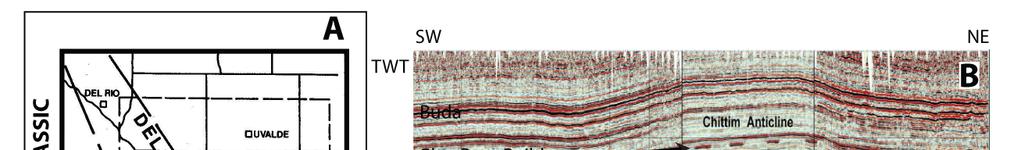


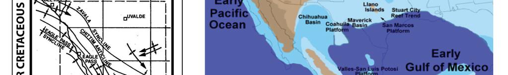
6 Structural & Paleogeographic g Setting
7 Sequence Stratigraphic Setting Upper Glen Rose: ~ 3.5 my, Sequence 8, unit 5 (this study). Corbula Marker Lower Glen Rose: ~ my, Sequences 6 and 7, units 1-4 (this study).
8 Dataset
9 Outline Introduction ti - Area of Study - Geological framework - Dataset Stratigraphic development of Patch Reefs Core description & plug measurements & well logs Seismic analysis (Stratal Slicing) Geomorphologic analysis of Buildups Conclusions


10 WELL 17-1 N 0.7 mi 1.13 km


11 Well 17-1 Rock Facies SKELETAL GS SKELETAL GDP 5: Skeletal-peloidal l l l GS to RS 4: Rudist-coral-stromatoporoid, skeletal-peloidal BS BOUNDSTONE SKELETAL MDP 5 mm 3: Rudist-coral-stromatoporoid, skeletal MDP/GDP to RS 2: Burrowed, oncoidal-skeletal MDP/GDP RUDSTONE SKELETAL WS/MS 1: Burrowed, skeletal WS/MS & skeletal MDP/GDP
12 WELL 17-1 N 0.7 mi 1.13 km
13 WELL 17-1 Low (5-20 GAPI) & Steady = Buildup High (>20 GAPI) & Variable = Open marine
14 Anhydrite Datum

15 Stratal Slices

16
17 Outline Introduction ti - Area of Study - Geological framework - Dataset Stratigraphic development of Patch Reefs Core description & plug measurements & well logs Seismic analysis (Stratal Slicing) Geomorphologic analysis of Buildups Conclusions
18 Geomorphologic analysis


")


19 Reef morphology: N Patch reef shape changes across the platform Wave energy changes too: Ocean swells (N-S) Wind-driven waves (W & NE Monsoons) 10 km Facies distribution within patch reefs is controlled by net wave energy plus tidal range m 100 m 100 m m 100 m 100 m

20 Steeper buildup walls to W and SW SS 6 U4 Stratal Slice 5 Stratal Slice 6 Stratal Slice 7
21 Steeper buildup walls to W and SW SS 6 U4 Stratal Slice 5 Stratal Slice 6 Stratal Slice 7
22 Steeper buildup walls to W and SW SS 6 U4 Stratal Slice 5 Stratal Slice 6 Stratal Slice 7
23 Geomorphometric SS C SS parameters D SS E Area decreases with time Perimeter decreases with time More Elliptical with time Long Axes=( )*short axes NNW-SSE Long Axes


 425")

24 Trade-Wind Summer Moonson Trade-Wind East Australian Current Barrier Longshore Drift + Northerns (cold winds) 425 patch reefs 104 patch reefs 134 patch reefs
25 Modern Buildup Geomorphometrics (25-50)x (0.5-1)x x/10 X: Maverick Buildups (3-6)x 1x x/(5-8) Circular shapes dominance = SS5 Long Axes=( )*short axes The same as Maverick Basin! Elongation direction = Trade-Wind (Coral Spawning) + Far-Field Current


26 How to apply hydrodynamics understanding? Far-Field Currents Trade- Winds? 0.7 mi 113k 1.13 km
27 Conclusions The Lower Glen Rose (Albian) buildups in the Maverick Basin: 1. Developed in three levels within the sequence 7. Two of the levels occurred within the TST. Buildups occurred as biostrome and bioherms with an arrangement of shoaling-reefal rock facies deposited mostly during 4 th order decreasing accommodation cycles. 2. Are mounded features elongated NNW-SSE with steeper sides to the SW. This asymmetry may have resulted from paleo-currents directed NNE and E paleo-trade-winds. The implication is that better reservoir rock facies locate to the SW side of the buildups. 3. Maybe preceded by shallow mud mounds.
28 THANKS
29 Shallow water Mud Mounds Candidates - Oyster Reefs: Texas coast, Murray Basin - S Australia (Pufahl & James 2006). - Halimeda (green algae) bioherms: GB Australia (Marshall & Davies, 1988). - Thalassia (sea grass) stabilized mud mounds: Florida, Rodriguez bank (Turmel & Swanson 1976), Tavernier bank (Bosence et al. 1985). - Biodetrital mud-shoals: Cangrejo and Bulkhead shoals in northern Belize (Mazzulo et al. 2003). - Microbial mounds: Lower Carboniferous SW Spain (Cózar et al. 2003). - Phylloid algae: El Hueco Mountains in Texas / New Mexico (Forsythe 2003) and Viséan Irish Platform (Somerville 2003).


30 Dataset
31 Buildups profile and Lithologic characterization

 - Unit 4 s prod. (26 wells): 38.5 BCF Prod.")
32 Production in Lower Glen Rose Buildups Chittim Gas Field: - Discovered First well prod.: >30 BCF (1981) This dataset (75 wells): - 17 wells drilled before 3D seismic (1993) - Unit 4 s prod. (26 wells): 38.5 BCF Prod. Range (>1970): BCF 12 wells : >1 BCF (>1970)
33 Seismic Analysis 130m 180m 0m 80m
34 Seismic Amplitude Facies & Gamma-Ray description I GR GR GR GR GR shale clean clean Buildups Positive Seismic Facies: GAPI & High S.D.
Seismic Geomorphology and Analysis of the Ordovician Paleokarst Drainage System in the Central Tabei Uplift, Northern Tarim Basin, Western China*
 Seismic Geomorphology and Analysis of the Ordovician Paleokarst Drainage System in the Central Tabei Uplift, Northern Tarim Basin, Western China* Hongliu Zeng 1, Robert Loucks 1, Xavier Janson 1, Quizhong
Bulletin of Earth Sciences of Thailand
 Quantitative Seismic Geomorphology of Early Miocene to Pleistocene Fluvial System of Northern Songkhla Basin, Gulf of Thailand Oanh Thi Tran Petroleum Geoscience Program, Department of Geology, Faculty
Sequence Stratigraphy of the Upper Cretaceous Niobrara Formation, A Bench, Wattenberg Field, Denver Julesburg Basin, Colorado*
 Sequence Stratigraphy of the Upper Cretaceous Niobrara Formation, A Bench, Wattenberg Field, Denver Julesburg Basin, Colorado* Lisa E. Remington LaChance 1 and Mark C. Robinson 1 Search and Discovery Article
3D Seismic Reservoir Characterization and Delineation in Carbonate Reservoir*
 3D Seismic Reservoir Characterization and Delineation in Carbonate Reservoir* M. N. Alamsyah 1, Bambang W. Handono 1, and Andri Syafriya 1 Search and Discovery Article #41760 (2016) Posted January 25,
Highstand Stacked Tidal Flat / Standing Water Evaporite Cycles of the Midale Evaporite in Southeast Saskatchewan, Mississippian Williston Basin*
 Highstand Stacked Tidal Flat / Standing Water Evaporite Cycles of the Midale Evaporite in Southeast Saskatchewan, Mississippian Williston Basin* J. H. Lake 1 and D. M. Kent 2 Search and Discovery Article
The Sequence Stratigraphic and Paleogeograhic Distribution of Reservoir-Quality Dolomite, Madison Formation, Wyoming and Montana
 The Sequence Stratigraphic and Paleogeograhic Distribution of Reservoir-Quality Dolomite, Madison Formation, Wyoming and Montana TAURY SMITH AND GREGOR EBERLI The primary aim of this study is to show the
Application of Borehole Imaging to Evaluate Porosity and Permeability in Carbonate Reservoirs: from Example from Permian Basin*
 Application of Borehole Imaging to Evaluate Porosity and Permeability in Carbonate Reservoirs: from Example from Permian Basin* D.V. (Vivek) Chitale 1, Clive Johnson 2, Hunter Manley 3, David Entzminger
Southern Songkhla Basin, Gulf of Thailand
 Architecture and Depositional Environment of Fluvial Systems of Southern Songkhla Basin, Gulf of Thailand Toan Manh Do Petroleum Geoscience Program, Department of Geology, Faculty of Science, Chulalongkorn
1 : TOTAL E&P, Technology Centre, CSTJF, Pau France 2 : ENSEGID - Bordeaux INP 3 : TOTAL E&P Qatar
 Stratigraphy and sedimentology of the middle Cenomanian Natih Formation in the Jabal Shams area (Jabal Akhdar, Sultanate of Oman): An outcrop analogue for reservoir heterogeneity in the Mishrif Formation
Porosity partitioning in sedimentary cycles: implications for reservoir modeling
 Porosity partitioning in sedimentary cycles: implications for reservoir modeling Gregor P. Eberli 1), Langhorne B. Smith 2), Elena Morettini 3), Layaan Al-Kharusi 1) 1) Comparative Sedimentology Laboratory,
SAND DISTRIBUTION AND RESERVOIR CHARACTERISTICS NORTH JAMJUREE FIELD, PATTANI BASIN, GULF OF THAILAND
 SAND DISTRIBUTION AND RESERVOIR CHARACTERISTICS NORTH JAMJUREE FIELD, PATTANI BASIN, GULF OF THAILAND Benjawan KIinkaew Petroleum Geoscience Program, Department of Geology, Faculty of Science, Chulalongkorn
Sedimentology and Stratigraphy of Lower Smackover Tight Oil Carbonates: Key to Predictive Understanding of Reservoir Quality and Distribution
 Integrated Reservoir Solutions Sedimentology and Stratigraphy of Lower Smackover Tight Oil Carbonates: Key to Predictive Understanding of Reservoir Quality and Distribution Roger J. Barnaby Presented at
Osareni C. Ogiesoba 1. Search and Discovery Article #10601 (2014)** Posted May 31, 2014
** Posted May 31, 2014") Seismic Multiattribute Analysis for Shale Gas/Oil within the Austin Chalk and Eagle Ford Shale in a Submarine Volcanic Terrain, Maverick Basin, South Texas* Osareni C. Ogiesoba 1 Search and Discovery Article
Seismic Multiattribute Analysis for Shale Gas/Oil within the Austin Chalk and Eagle Ford Shale in a Submarine Volcanic Terrain, Maverick Basin, South Texas* Osareni C. Ogiesoba 1 Search and Discovery Article
Aptian/Albian Reservoir Development in the Jeanne d Arc Basin, Offshore Eastern Canada
 Aptian/Albian Reservoir Development in the Jeanne d Arc Basin, Offshore Eastern Canada Jonathan Marshall, Statoil Canada Ltd. Calgary, Alberta, Canada. jomars@statoil.com Introduction: The Jeanne d Arc
APPENDIX C GEOLOGICAL CHANCE OF SUCCESS RYDER SCOTT COMPANY PETROLEUM CONSULTANTS
 APPENDIX C GEOLOGICAL CHANCE OF SUCCESS Page 2 The Geological Chance of Success is intended to evaluate the probability that a functioning petroleum system is in place for each prospective reservoir. The
Sequence Stratigraphic Analysis of Mixed, Reefal Carbonate and Siliciclastic Systems. Ashton Embry. Geological Survey of Canada.
 Sequence Stratigraphic Analysis of Mixed, Reefal Carbonate and Siliciclastic Systems Ashton Embry Geological Survey of Canada Outline Sequence Stratigraphy Sequence Surfaces and Sequence Boundaries for
Project Description: MODELING FLOW IN VUGGY MEDIA. Todd Arbogast, Mathematics
 Project Description: MODELING FLOW IN VUGGY MEDIA Todd Arbogast, Mathematics Steve Bryant, Petroleum & Geosystems Engineering Jim Jennings, Bureau of Economic Geology Charlie Kerans, Bureau of Economic
Reservoir Characterization Research Laboratory for Carbonate Studies. Research Plans for 2007
 Reservoir Characterization Research Laboratory for Carbonate Studies Research Plans for 2007 Outcrop and Subsurface Characterization of Carbonate Reservoirs for Improved Recovery of Remaining Hydrocarbons
FY 2013 Annual Technical Report for NCRDS State Cooperative Program
 FY 2013 Annual Technical Report for NCRDS State Cooperative Program SUBSURFACE GAS-SHALE SAMPLES OF THE UPPER DEVONIAN AND LOWER MISSISSIPPIAN WOODFORD SHALE, PERMIAN BASIN, WEST TEXAS AND SOUTHEASTERN
Osareni C. Ogiesoba and Angela K. Eluwa. Bureau of Economic Geology, University of Texas at Austin, Burnet Rd., Austin Texas 78759
 Structural Styles of Eocene Jackson and Oligocene Vicksburg Formations within the Rio Grande and Houston Embayments near the San Marcos Arch, Refugio and Calhoun Counties, South Texas Gulf Coast Osareni
Serica Energy (UK) Limited. P.1840 Relinquishment Report. Blocks 210/19a & 210/20a. UK Northern North Sea
 Limited. P.1840 Relinquishment Report. Blocks 210/19a & 210/20a. UK Northern North Sea") Serica Energy (UK) Limited P.1840 Relinquishment Report Blocks 210/19a & 210/20a UK Northern North Sea January 2013 1 Header Licence: P.1840 Round: Licence Type: 26th Round Traditional "Drill-or-Drop"
Serica Energy (UK) Limited P.1840 Relinquishment Report Blocks 210/19a & 210/20a UK Northern North Sea January 2013 1 Header Licence: P.1840 Round: Licence Type: 26th Round Traditional "Drill-or-Drop"
Drainage Systems in Rift Basins: Implications for Reservoir Quality*
 Drainage Systems in Rift Basins: Implications for Reservoir Quality* Stephen Schwarz 1 and Lesli Wood 2 Search and Discovery Article #30477 (2016)** Posted December 5, 2016 *Adapted from oral presentation
AAPG International Conference: October 24-27, 2004; Cancun, Mexico
 and Seismic Attributes in the Continental Shelf of Eastern Mexico Khaled Fouad, L. Frank Brown, Jr., William A. Ambrose, Dallas Dunlap, Bureau of Economic Geology, Jackson School of Geosciences, The University
How to Log Core (With Examples from the Williston Basin of Southeast Saskatchewan)
") How to Log Core (With Examples from the Williston Basin of Southeast Saskatchewan) D.M.Kent ( D.M.Kent Geological Consulting Ltd., Regina, Sask.), and J.H.Lake, (Lake Geological Services Inc, Swift Current,
How to Log Core (With Examples from the Williston Basin of Southeast Saskatchewan) D.M.Kent ( D.M.Kent Geological Consulting Ltd., Regina, Sask.), and J.H.Lake, (Lake Geological Services Inc, Swift Current,
ON THE EVOLUTION OF A HOLOCENE BARRIER COAST
 ON THE EVOLUTION OF A HOLOCENE BARRIER COAST Response to sea-level change and sediment supply DANCORE Seminar 2014 COADAPT - Danish Coasts and Climate Adaptation Flooding Risk and Coastal Protection Mikkel
Bulletin of Earth Sciences of Thailand. Evaluation of the Petroleum Systems in the Lanta-Similan Area, Northern Pattani Basin, Gulf of Thailand
 Evaluation of the Petroleum Systems in the Lanta-Similan Area, Northern Pattani Basin, Gulf of Thailand Sirajum Munira Petroleum Geoscience Program, Department of Geology, Faculty of Science, Chulalongkorn
Masila 1: Shallow shelf carbonate facies variability and secondary reservoir development - Saar Formation Masila block, Yemen
 Masila 1: Shallow shelf carbonate facies variability and secondary reservoir development - Saar Formation Masila block, Yemen Kent Wilkinson* Nexen Inc., Calgary, AB kent_wilkinson@nexeninc.com ABSTRACT
Controls on clastic systems in the Angoche basin, Mozambique: tectonics, contourites and petroleum systems
 P2-2-13 Controls on clastic systems in the Angoche basin, Mozambique: tectonics, contourites and petroleum systems Eva Hollebeek, Olivia Osicki, Duplo Kornpihl Schlumberger, London, UK Introduction Offshore
In 1990, 50% of the U.S. population lived within 75 km of a coast. By 2010, 75% of the U.S. population will live within 75 km of a coast.
 In 1990, 50% of the U.S. population lived within 75 km of a coast. By 2010, 75% of the U.S. population will live within 75 km of a coast. High Tech Methods for Surveying the Deep Sea Floor Fig. 20.18 1
THE NORPHLET SANDSTONE AND OTHER PETROLEUM PLAYS ALONG AND OUTBOARD OF THE FLORIDA ESCARPMENT, EASTERN GULF OF MEXICO
 THE NORPHLET SANDSTONE AND OTHER PETROLEUM PLAYS ALONG AND OUTBOARD OF THE FLORIDA ESCARPMENT, EASTERN GULF OF MEXICO Glyn Roberts 1, Joe Erickson 2 1 Consultant, Bedford, UK; 2 Spectrum, Houston, TX.
High Resolution Field-based Studies of Hydrodynamics Examples from the North Sea
 High Resolution Field-based Studies of Hydrodynamics Examples from the North Sea Stephen O Connor 1, Richard Swarbrick 2 and Sam Green 1 1 Ikon GeoPressure, Durham, UK 2 Swarbrick Geopressure Consultancy,
Case Study of the Structural and Depositional-Evolution Interpretation from Seismic Data*
 Case Study of the Structural and Depositional-Evolution Interpretation from Seismic Data* Yun Ling 1, Xiangyu Guo 1, Jixiang Lin 1, and Desheng Sun 1 Search and Discovery Article #20143 (2012) Posted April
Pre Stack Imaging To Delineate A New Hydrocarbon Play A Case History
 5th Conference & Exposition on Petroleum Geophysics, Hyderabad-2004, India PP 375-379 Pre Stack Imaging To Delineate A New Hydrocarbon Play A Case History D. Srinivas, T.R. Murali Mohan, Ashwani Lamba,
Luderitz Basin, Offshore Namibia: Farm-out Opportunity. APPEX, London, March 2015 Graham Pritchard, Serica Energy plc
 Luderitz Basin, Offshore Namibia: Farm-out Opportunity APPEX, London, March 2015 Graham Pritchard, Serica Energy plc Serica Luderitz Basin Namibia Introduction Serica (85%, operator) 17,384 km 2 acreage
Evan K. Franseen, Dustin Stolz, Robert H. Goldstein, KICC, Department of Geology, University of Kansas
 Reservoir Character of the Avalon Shale (Bone Spring Formation) of the Delaware Basin, West Texas and Southeast New Mexico: Effect of Carbonate-rich Sediment Gravity Flows Evan K. Franseen, Dustin Stolz,
Quantitative Seismic Interpretation An Earth Modeling Perspective
 Quantitative Seismic Interpretation An Earth Modeling Perspective Damien Thenin*, RPS, Calgary, AB, Canada TheninD@rpsgroup.com Ron Larson, RPS, Calgary, AB, Canada LarsonR@rpsgroup.com Summary Earth models
Constraining Uncertainty in Static Reservoir Modeling: A Case Study from Namorado Field, Brazil*
 Constraining Uncertainty in Static Reservoir Modeling: A Case Study from Namorado Field, Brazil* Juliana F. Bueno 1, Rodrigo D. Drummond 1, Alexandre C. Vidal 1, Emilson P. Leite 1, and Sérgio S. Sancevero
Cretaceous USM Reservoir, F-O Gas Field, Offshore South Africa: Sedimentological Factors Affecting Economic Viability*
 Cretaceous USM Reservoir, F-O Gas Field, Offshore South Africa: Sedimentological Factors Affecting Economic Viability* Roger Higgs 1 Search and Discovery Article #20072 (2009) Posted May 20, 2009 *Adapted
Depositional Sequences Sequences
 Depositional Sequences Transgressive and Regressive packages can be bound by unconformities Because sediment can only be preserved during net aggradation and progradation All other times there is either
Arthur Saller 1. Search and Discovery Article #51393 (2017)** Posted June 26, Abstract
** Posted June 26, Abstract") PS Mixed Carbonates and Siliciclastics North of the Mahakam Delta, Offshore East Kalimantan, Indonesia* Arthur Saller 1 Search and Discovery Article #51393 (2017)** Posted June 26, 2017 *Adapted from poster
PS Mixed Carbonates and Siliciclastics North of the Mahakam Delta, Offshore East Kalimantan, Indonesia* Arthur Saller 1 Search and Discovery Article #51393 (2017)** Posted June 26, 2017 *Adapted from poster
Bank - An Analog for Carbonate Sand Reservoirs*
 PS Satellite Imagery and Geological Interpretation of the Exumas, Great Bahama Bank - An Analog for Carbonate Sand Reservoirs* Paul (Mitch) Harris 1 and James Ellis 2 Search and Discovery Article #50200
Evolution of the Geological Model, Lobster Field (Ewing Bank 873)
") Evolution of the Geological Model, Lobster Field (Ewing Bank 873) M.K. Burk, Marathon Oil Company G.L. Brown, Marathon Oil Company D.R. Petro, Marathon Oil Company Throughout the life of a field an accurate
Evolution of the Geological Model, Lobster Field (Ewing Bank 873) M.K. Burk, Marathon Oil Company G.L. Brown, Marathon Oil Company D.R. Petro, Marathon Oil Company Throughout the life of a field an accurate
OUTCROP! CHARACTERISATION! OF! TRANSGRESSIVE! SANDSTONE! RESERVOIRS:! QUANTITATIVE!COMPARISON!OF!OUTCROP!ANALOGUES!
 OUTCROP CHARACTERISATION OF TRANSGRESSIVE SANDSTONE RESERVOIRS: QUANTITATIVECOMPARISONOFOUTCROPANALOGUES OLIVER D. JORDAN 1, PETER J. SIXSMITH 2, GARY J. HAMPSON, SANJEEV GUPTA & HOWARDD.JOHNSON DepartmentofEarthScienceandEngineering,ImperialCollegeLondon,SouthKensington
In a marine environment, topographic features on the sea
 Coordinated by ALAN JACKSON Seismic attribute expression of differential compaction SATINDER CHOPRA, Arcis Seismic Solutions, Calgary, Canada KURT J. MARFURT, University of Oklahoma, Norman, USA In a marine
A Microseismic Case Study: Cotton Valley Taylor Sandstones, Overton Field, Texas
 A Microseismic Case Study: Cotton Valley Taylor Sandstones, Overton Field, Texas Nick B. Pollard 1 and Nicole Elhaj 2 1 Tanos Exploration II, LLC, 821 ESE Loop 323, Ste. 400, Tyler, Texas 75701 2 Maverick
Interaction between Faults and Igneous Intrusions in Sedimentary Basins: Insights from 3D Seismic Reflection Data*
 Interaction between Faults and Igneous Intrusions in Sedimentary Basins: Insights from 3D Seismic Reflection Data* Craig Magee¹, Christopher A. Jackson¹, and Nick Schofield² Search and Discovery Article
DATA ANALYSIS AND INTERPRETATION
 III. DATA ANALYSIS AND INTERPRETATION 3.1. Rift Geometry Identification Based on recent analysis of modern and ancient rifts, many previous workers concluded that the basic structural unit of continental
Predicting Gas Hydrates Using Prestack Seismic Data in Deepwater Gulf of Mexico (JIP Projects)
") Predicting Gas Hydrates Using Prestack Seismic Data in Deepwater Gulf of Mexico (JIP Projects) Dianna Shelander 1, Jianchun Dai 2, George Bunge 1, Dan McConnell 3, Niranjan Banik 2 1 Schlumberger / DCS
Predicting Gas Hydrates Using Prestack Seismic Data in Deepwater Gulf of Mexico (JIP Projects) Dianna Shelander 1, Jianchun Dai 2, George Bunge 1, Dan McConnell 3, Niranjan Banik 2 1 Schlumberger / DCS
Revised reservoir model for the Paleocene mounds of the Utsira High, North Sea, Norway John Wild (1) & Nowell Briedis (2)
 & Nowell Briedis (2)") Revised reservoir model for the Paleocene mounds of the Utsira High, North Sea, Norway John Wild (1) & Nowell Briedis (2) (1) Mobil North Sea LLC (2) Esso Exploration & Production Norway A/S (ExxonMobil
Revised reservoir model for the Paleocene mounds of the Utsira High, North Sea, Norway John Wild (1) & Nowell Briedis (2) (1) Mobil North Sea LLC (2) Esso Exploration & Production Norway A/S (ExxonMobil
Sequence Stratigraphy. Historical Perspective
 Sequence Stratigraphy Historical Perspective Sequence Stratigraphy Sequence Stratigraphy is the subdivision of sedimentary basin fills into genetic packages bounded by unconformities and their correlative
Challenging the Paradigm. missing section = normal fault
 Challenging the Paradigm missing section = normal fault Implications for hydrocarbon exploration Jean-Yves Chatellier Talisman Energy Inc Introduction pozo mata sismica Meaning that data from a well has
Bulletin of Earth Sciences of Thailand
 Depositional Environments and Stratigraphic Development of the Grand Taman Sari Circuit Outcrop: an Analogue for Transgressive Mahakam Delta Successions Ridha Santika Riadi Petroleum Geoscience Program,
Orphan Basin, Offshore Newfoundland: New seismic data and hydrocarbon plays for a dormant Frontier Basin
 Orphan Basin, Offshore Newfoundland: New seismic data and hydrocarbon plays for a dormant Frontier Basin Jerry Smee* G&G Exploration Consulting, 301 400-3rd Avenue SW, Calgary, AB, T2P 4H2 Sam Nader, Paul
Field trip to Racine Reef Complex, Thornton Quarry, Illinois
 Field trip to Racine Reef Complex, Thornton Quarry, Illinois Primary objectives for this fieldtrip 1) Collect and identify the fossils of the Racine Reef Complex. 2) Discuss procedures for collecting fossil
Main Challenges and Uncertainties for Oil Production from Turbidite Reservoirs in Deep Water Campos Basin, Brazil*
 Main Challenges and Uncertainties for Oil Production from Turbidite Reservoirs in Deep Water Campos Basin, Brazil* Carlos H. Bruhn 1, Antonio Pinto 1, and Paulo R. Johann 1 Search and Discovery Article
Analogs to the San Andres Horizontal Play? A Fresh Look at the Glorieta Yeso Play in Southeastern New Mexico
 Analogs to the San Andres Horizontal Play? A Fresh Look at the Glorieta Yeso Play in Southeastern New Mexico December 2018 Steve Melzer* Evan Allard** With Considerable Assistance & Advice from R. Trentham,
The Impact of Changing Winds on Estuarine Evolution, Copano Bay, TX
 The Impact of Changing Winds on Estuarine Evolution, Copano Bay, TX Purpose: The fulfillment of partial requirements for the Degree of Master of Science in Geology Oklahoma State University, Stillwater
The Capitan Aquifer - Ellenburger Production Wells Geothermal Engine Source?
 GEOTHERMAL ENERGY UTILIZATION ASSOCIATED WITH OIL & GAS DEVELOPMENT June 17-18, 2008 Southern Methodist University Dallas, Texas The Capitan Aquifer - Ellenburger Production Wells Geothermal Engine Source?
Vertical Hydrocarbon Migration at the Nigerian Continental Slope: Applications of Seismic Mapping Techniques.
 ROAR HEGGLAND, Statoil ASA, N-4035 Stavanger, Norway Vertical Hydrocarbon Migration at the Nigerian Continental Slope: Applications of Seismic Mapping Techniques. Summary By the use of 3D seismic data,
The Stratigraphic Trap in the Benchamas Field Pattani Basin, Gulf of Thailand
 The Stratigraphic Trap in the Benchamas Field Pattani Basin, Gulf of Thailand Jurairat Buangam Petroleum Geoscience Program, Department of Geology, Faculty of Science, Chulalongkorn University, Bangkok
Brief report on Belize carbonate environments field trip Feb. 2012
 Brief report on Belize carbonate environments field trip Feb. 2012 In february 2012 I travelled to San Pedro (Ambergris Caye) Belize (Figure 1) to examine and study depositional environments of carbonate
Offshore Geosequestration Potential in the Gulf of Mexico. Carbon Sequestration Opportunities in the North Sea Conference March, 2010
 Offshore Geosequestration Potential in the Gulf of Mexico Presenter: Ramón Treviño Gulf Coast Carbon Center Bureau of Economic Geology University of Texas at Austin, Carbon Sequestration Opportunities
By Paul M. (Mitch) Harris 1 and Barry J. Katz 2. Search and Discovery Article #40305 (2008) Posted September 4, Abstract
 Harris 1 and Barry J. Katz 2. Search and Discovery Article #40305 (2008) Posted September 4, Abstract") PS Carbonate Mud and Carbonate Source Rocks* By Paul M. (Mitch) Harris 1 and Barry J. Katz 2 Search and Discovery Article #435 (28) Posted September 4, 28 *Adapted from poster presentation at AAPG Annual
PS Carbonate Mud and Carbonate Source Rocks* By Paul M. (Mitch) Harris 1 and Barry J. Katz 2 Search and Discovery Article #435 (28) Posted September 4, 28 *Adapted from poster presentation at AAPG Annual
ANGOLA OFFSHORE LICENSING 2007 BLOCK 46
 AGOLA OFFHOR LICIG 2007 BLOCK 46 DATA BA AVAILABILITY Figure 1 shows the seismic data available on Block 46. Fig. 1 Commercial 2D surveys: esterngeco: 794 km. GX Technology: 116 km. Commercial 3D surveys:
The Application of Data Conditioning, Frequency Decomposition, and RGB Colour Blending in the Gohta Discovery (Barents Sea, Norway)*
*") Click to View Slides The Application of Data Conditioning, Frequency Decomposition, and RGB Colour Blending in the Gohta Discovery (Barents Sea, Norway)* Syed Fakhar Gilani 1, and Luis Gomez 2, and Ryan
Click to View Slides The Application of Data Conditioning, Frequency Decomposition, and RGB Colour Blending in the Gohta Discovery (Barents Sea, Norway)* Syed Fakhar Gilani 1, and Luis Gomez 2, and Ryan
Thesis Proposal: Salt Reconstruction and Study of Depositional History, Upper Jurassic, East Texas Basin
 Thesis Proposal: Salt Reconstruction and Study of Depositional History, Upper Jurassic, East Texas Basin By: Krista Mondelli Advisor: Dr. Chris Liner April, 2009 2 Introduction The East Texas Basin covers
Outline 16: The Mesozoic World: Formation of Oil Deposits (with a side trip to the Devonian Marcellus Shale)
") Outline 16: The Mesozoic World: Formation of Oil Deposits (with a side trip to the Devonian Marcellus Shale) The first commercial oil well was drilled by Colonel Edwin Drake in Titusville, Pennsylvania,
Outline 16: The Mesozoic World: Formation of Oil Deposits (with a side trip to the Devonian Marcellus Shale) The first commercial oil well was drilled by Colonel Edwin Drake in Titusville, Pennsylvania,
MUHAMMAD S TAMANNAI, DOUGLAS WINSTONE, IAN DEIGHTON & PETER CONN, TGS Nopec Geological Products and Services, London, United Kingdom
 Geological and Geophysical Evaluation of Offshore Morondava Frontier Basin based on Satellite Gravity, Well and regional 2D Seismic Data Interpretation MUHAMMAD S TAMANNAI, DOUGLAS WINSTONE, IAN DEIGHTON
Outcrops from Every Continent and 20 Countries in 140 Contributions. Tor H. Nilsen, Roger D. Shew, Gary S. Steffens, and Joseph R.J. Studlick.
 Paper VIII Tor H. Nilsen, Roger D. Shew, Gary S. Steffens, and Joseph R.J. Studlick Editors Outcrops from Every Continent and 20 Countries in 140 Contributions http://bookstore.aapg.org Length ~ 23 m (75.5
Supplementary Material
 GSA Data Repository item 2018118 Brardinoni, F., Picotti, V., Maraio, S., Paolo Bruno, P., Cucato, M., Morelli, C., and Mair, V., 2018, Postglacial evolution of a formerly glaciated valley: Reconstructing
OIL INDIA LIMITED, GEOPHYSICS DEPARTMENT, DULIAJAN, ASSAM.
 J. P. Singh, M. K. Gupta & Akshaya Kumar, Oil India Limited, Duliajan. jpsingh@oilindia.in Summary Oil exploration in Upper Assam commenced with the discovery of the Digboi oilfield more than 100 years
The Late Quaternary Rio Grande Delta A Distinctive, Underappreciated Geologic System
 The Late Quaternary Rio Grande Delta A Distinctive, Underappreciated Geologic System Thomas E. Ewing 1 and Juan L. Gonzalez 2 1 Frontera Exploration Consultants, 19240 Redland Rd., Ste. 250, San Antonio,
Offshore Evidence for Uplift Rate Boundaries. Hans AbramsonWard Diablo Canyon SSHAC SSC Workshop 2 November 7, 2012
 Offshore Evidence for Uplift Rate Boundaries Hans AbramsonWard Diablo Canyon SSHAC SSC Workshop 2 November 7, 2012 Questions asked by the TI team Discuss your ability to distinguish and correlate offshore
Introduction to Oceanography. Chapter 2: Plate Tectonics Overview
 Introduction to Oceanography Chapter 2: Plate Tectonics Overview Much evidence supports plate tectonics theory. The plate tectonics model describes features and processes on Earth. Plate tectonic science
Accommodation. Tectonics (local to regional) Subsidence Uplift
 Subsidence Uplift") Accommodation Accommodation varies over time; it is the distance between a reference horizon and the sea surface (i.e. relative sea level). The space to be filled in with sediments or water What are the
Accommodation Accommodation varies over time; it is the distance between a reference horizon and the sea surface (i.e. relative sea level). The space to be filled in with sediments or water What are the
Fusselman/Devonian Study. of the Midland Basin, Texas
 Fusselman/Devonian Study of the Midland Basin, Texas Fusselman-Devonian Study of the Midland Basin, Texas Overview The Fusselman-Devonian study of the Midland Basin is designed to enhance both exploration
Reservoir Characterization of the Swan Hills Eastern Platform Trend; a Multi-disciplinary Approach in Building an Applied Model
 Reservoir Characterization of the Swan Hills Eastern Platform Trend; a Multi-disciplinary Approach in Building an Applied Model Thanos A. Natras*, Arcan Resources Ltd., Calgary, Alberta tnatras@arcanres.com
Effects of Tides on Deltaic Deposition: Causes and Responses*
 Effects of Tides on Deltaic Deposition: Causes and Responses* Piret Plink-Bjorklund 1 Search and Discovery Article #50626 (2012)** Posted June 25, 2012 *Adapted from oral presentation at AAPG Annual Convention
3D geological model for a gas-saturated reservoir based on simultaneous deterministic partial stack inversion.
 first break volume 28, June 2010 special topic A New Spring for Geoscience 3D geological model for a gas-saturated reservoir based on simultaneous deterministic partial stack inversion. I. Yakovlev, Y.
EGAS. Ministry of Petroleum
 EGAS Ministry of Petroleum EGAS Ministry of Petroleum About The Block Location: N. Thekah offshore block is located at about 56 km to the north of the Mediterranean shore line, 85 km to the north west
The Sea Floor. Chapter 2
 The Sea Floor Chapter 2 Geography of the Ocean Basins World ocean is the predominant feature on the Earth in total area Northern Hemisphere = 61% of the total area is ocean. Southern Hemisphere = about
Stratigraphic Architecture and Key Stratigraphic Surfaces Formed by Punctuated Flow Events - An Experiment on Fluviodeltaic Responses*
 Click to view movie-steady State Click to view movie-high Flow 1 Click to view movie- Low Flow 1 Click to view movie-high Flow Click to view movie-low Flow Note: If video clips do not function properly,
Determine the azimuths of conjugate fracture trends in the subsurface
 Reconnaissance of geological prospectivity and reservoir characterization using multiple seismic attributes on 3-D surveys: an example from hydrothermal dolomite, Devonian Slave Point Formation, northeast
RKC Newsltter-Direct Hydrocarbon Indicators.
 RKC Newsltter-Direct Hydrocarbon Indicators. This article will discuss a few oddball seismic facies associated with fluid expulsion-be it water or hydrocarbons, and some of the less obvious effects that
Petroleum Potential of the Application Area L12-4
 Petroleum Potential of the Application Area L12-4 The Application Area (L12-4) is underlain by the western Officer Basin, beneath the Gunbarrel Basin. The general basin architecture is outlined in Figure
TITLE: MULTIDISCIPLINARY IMAGING OF ROCK PROPERTIES IN CARBONATE RESERVOIRS FOR FLOW-UNIT TARGETING SEMI-ANNUAL TECHNICAL REPORT
 TITLE: MULTIDISCIPLINARY IMAGING OF ROCK PROPERTIES IN CARBONATE RESERVOIRS FOR FLOW-UNIT TARGETING SEMI-ANNUAL TECHNICAL REPORT Reporting Period: 5/16/02 11/15/02 Author: Stephen C. Ruppel January 2003
An Analytic Approach to Sweetspot Mapping in the Eagle Ford Unconventional Play
 An Analytic Approach to Sweetspot Mapping in the Eagle Ford Unconventional Play Murray Roth*, Transform Software and Services, Denver, Colorado, Murray@transformsw.com Michael Roth, Transform Software
entered a rapid development phase. Annual increased proven reserves are above 500 billion cubic meters (bcm) from 2003, and annual natural gas product
 from 2003, and annual natural gas product") (), entered a rapid development phase. Annual increased proven reserves are above 500 billion cubic meters (bcm) from 2003, and annual natural gas production has increased from 50bcm in 2000 to nearly
(), entered a rapid development phase. Annual increased proven reserves are above 500 billion cubic meters (bcm) from 2003, and annual natural gas production has increased from 50bcm in 2000 to nearly
Maturity Modeling of Gomin and South Gomin fields Southern Pattani Basin, Gulf of Thailand
 Maturity Modeling of Gomin and South Gomin fields Southern Pattani Basin, Gulf of Thailand Patinya Jaithan Petroleum Geoscience Program, Department of Geology, Faculty of Science, Chulalongkorn University,
Chapter 4 Implications of paleoceanography and paleoclimate
 Age ka / Chapter 4 Implications of paleoceanography and paleoclimate 4.1 Paleoclimate expression 4.2 Implications of paleocirculation and tectonics 4.3 Paleoenvironmental reconstruction MD05-2901 (Liu
Application of Predictive Modeling to the Lower Cretaceous Sedimentary Sequences of the Central Scotian Basin
 Application of Predictive Modeling to the Lower Cretaceous Sedimentary Sequences of the Central Scotian Basin Christopher R. Sangster 1, Nicolas Hawie 2, Georgia Pe-Piper 1, Francky Saint-Ange 2, David
Geological Classification of Seismic-Inversion Data in the Doba Basin of Chad*
 Geological Classification of Seismic-Inversion Data in the Doba Basin of Chad* Carl Reine 1, Chris Szelewski 2, and Chaminda Sandanayake 3 Search and Discovery Article #41899 (2016)** Posted September
Gulf of México Mapping NATCARB Atlas
 Gulf of México Mapping NATCARB Atlas Presenter: Ramón Treviño Gulf Coast Carbon Center University of Texas at Austin, Bureau of Economic Geology NACAP Cuernavaca, Morelos, México March 9, 2010 Acknowledgements
Sequence Stratigraphy as a tool for water resources management in alluvial coastal aquifers: application to the Llobregat delta (Barcelona, Spain)
") Sequence Stratigraphy as a tool for water resources management in alluvial coastal aquifers: application to the Llobregat delta (Barcelona, Spain) Desiré Gàmez Torrent December 2007 CHAPTER 1: Introduction
Sequence Stratigraphy as a tool for water resources management in alluvial coastal aquifers: application to the Llobregat delta (Barcelona, Spain) Desiré Gàmez Torrent December 2007 CHAPTER 1: Introduction
Trapping Mechanisms along North Similan and Lanta Trends, Pattani Basin, Gulf of Thailand
 Trapping Mechanisms along North Similan and Lanta Trends, Pattani Basin, Gulf of Thailand Piyaporn Aukkanit Petroleum Geoscience Program, Department of Geology, Faculty of Science, Chulalongkorn University,
Demystifying Tight-gas Reservoirs using Multi-scale Seismic Data
 Demystifying Tight-gas Reservoirs using Multi-scale Seismic Data Overview Murray Roth* Transform Software and Services, Inc., Littleton, CO murray@transformsw.com Tom Davis Colorado School of Mines, Golden,
Kilometre-Scale Uplift of the Early Cretaceous Rift Section, Camamu Basin, Offshore North-East Brazil*
 Kilometre-Scale Uplift of the Early Cretaceous Rift Section, Camamu Basin, Offshore North-East Brazil* Iain Scotchman 1 and Dario Chiossi 2 Search and Discovery Article #50183 (2009) Posted May 20, 2009
Downloaded 09/16/16 to Redistribution subject to SEG license or copyright; see Terms of Use at
 Data Using a Facies Based Bayesian Seismic Inversion, Forties Field, UKCS Kester Waters* (Ikon Science Ltd), Ana Somoza (Ikon Science Ltd), Grant Byerley (Apache Corp), Phil Rose (Apache UK) Summary The
The Carboniferous-Permian Reef Play in the Sverdrup Basin: Dare to Dream
 The Carboniferous-Permian Reef Play in the Sverdrup Basin: Dare to Dream B. Beauchamp * Department of Geoscience, University of Calgary, Calgary, Alberta, Canada bbeaucha@ucalgary.ca M. Wamsteeker Imperial
Paleo History of a Deeper Level Tidal Lobe and its Facies Analysis : A Case Study
 Paleo History of a Deeper Level Tidal Lobe and its Facies Analysis : A Case Study V Chaganti*, T B Singh*, J K Bora*, Dr. Mahendra Pratap* Abstract Hydrocarbon exploitation is a play to exploit the Paleo