'Contribution to Canada-Ontario Mineral Development Agreement Project carried by Geological Survey of Canada.
|
|
|
- Dwain Hicks
- 6 years ago
- Views:
Transcription
1 Delineation of bedrock topography at Val Gagne, Ontario, using seismic reflection techniques' Project S.E. Pullan, J.A. Hunter, R.M. Gagne, and R.L. Good Terrain Sciences Division Pullan, S.E., Hunter, J.A., Gagne, R.M., and Good R.L., Delineation of bedrock topography at Val Gagne, Ontario, using seismic reflection techniques; in Current Research, Part A, Geological Survey of Canada, Paper 87-1A, p , Abstract Optimum offset shallow seismic reflection sections from the Val Gagne, Ontario, test site show excellent agreement with available borehole logs. Bedrock topography and structure within the overburden, including the delineation of occurrences of till, were interpreted from the seismic profiles. The results of this survey indicate that the optimum offset shallow reflection technique could be a valuable tool in exploration programs in northern Ontario and Quebec where overburden drilling is used for gold prospecting. With the seismic information available prior to drilling, drillsites could be selected to sample thick pockets of till or specifically located in the glacial-lee of buried bedrock highs in order to maximize the useful returns of each borehole. Resume Les profils de Val Gagne, en Ontario, obtenues au moyen d'une technique de sismique reflexion peu profonde a decalage optimal, concordent tres bien avec les diagraphies disponibles. A partir de ces profils sismiques, on a reconstitue la topographie et la structure de la roche en place a l'interieur du terrain de recouvrement et delimite les accumulations de till. Les resultats de ce sondage indiquent que la technique de sismique reflexion peu profonde a decalage optimal pourrait etre un outil d'exploration precieux dans le nord de l'ontario et du Quebec, ou la prospection des gisements d'or s'effectue par forage dans des sediments meubles de recouvrement. Grace aux donnees sismiques recueillies avant le forage, on pourrait ainsi choisir les lieux de forage de facon a pouvoir prelever des echantillons des epaisses accumulations de till ou, plus particulierement, les etablir sur le versant des elevations de roche en place oriente dans la direction de l'ecoulement glaciaire, afin de tirer le maximum de chaque sondage. 'Contribution to Canada-Ontario Mineral Development Agreement Project carried by Geological Survey of Canada.
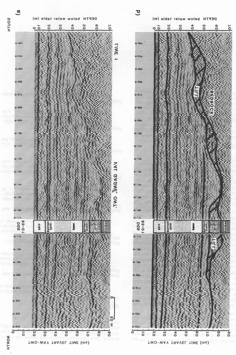
2 INTRODUCTION With the development of digital enhancement engineering seismographs and the concurrent proliferation of microcomputers over the last decade, it has become possible to apply seismic reflection techniques, well established since the 1930s in the oil industry, to shallow engineering or groundwater problems. The Terrain Geophysics Section of the Geological Survey of Canada has been developing shallow reflection methods and software to process the data since 1980 (Hunter et a]., 1982a,b). The methods are now well established and have been tested in many areas of Canada (Hunter et al., 1984). This report describes a survey where this technique has been applied to a mining exploration problem to illustrate its potential usefulness in future exploration programs. In the Matheson/Val Gagne area, east of Timmins, Ontario, gold prospecting has been inhibited by the thickness of the overburden. The area is covered by varying thicknesses of clay, silt, and/or sand, overlying pockets of till above the bedrock. The average depth to bedrock in 42 holes drilled in the area in 1984 by the Ontario Geological Survey (OGS) was 35 rn (Jensen et al., 1985). The standard current exploration procedure is to drill and sample any tills that are encountered above bedrock. The samples are then assayed for gold content, and, if this is significant, drilling continues in the "up-ice" direction in search of the "mother lode". Under ideal conditions drillholes would be positioned in the glacial lee of buried bedrock highs where thick occurrences of till are likely to be found, but without any prior knowledge of the subsurface structure, much of the initial exploratory drilling is blind. It is estimated that as many as 25% of such drillholes encounter no till (R.B. Barlow, personal communication, 1986) if no geophysical definition of the subsurface is available. Our initial work in the Val Gagne area in 1985 was done at the request of R. B. Barlow of the Ontario Geological Survey. Prior to our seismic surveying he had carried out airborne and ground electromagnetic (EM) field and interpretation work that had demonstrated the utility of these methods for indicating the presence of till pockets coincident with bedrock valleys. This then provided regional overburden drilling targets. Although the lateral extent of till pockets could be outlined by various imaging techniques applied to the EM data, resolving the vertical section (i.e., precise depths and thicknesses) through one-dimensional sounding interpretation methods requires much further research. He suggested that collaborative efforts, using seismic reflection methods together with EM methods, would allow the possibility of further advancing the electromagnetic interpretation problem, while at the same time demonstrating the capability of the seismic reflection method for resolving the complex vertical stratigraphy of the Quaternary sections in the area. Seismic tests in 1985, at various sites selected on the basis of EM surveys conducted by OGS, proved the feasibility of this approach. In 1986 we applied the "optimum offset" reflection technique on a production basis at a test site near Val Gagne, Ontario. Data from this test site are presented below, along with corroborative drillhole data from recent OGS drilling programs (OGS, 1986). METHOD The "optimum offset" shallow seismic reflection profiling technique has been described by Hunter et al. (1984). Under optimum conditions this technique allows an accurate and detailed delineation of the overburden-bedrock contact and of the structure within the overburden, even when the subsurface structure is fairly complex. The resolution depends on the frequency of seismic energy that can be returned from the target reflector to the surface. We have found that the best conditions occur when the near-surface materials are fine grained and water saturated. Such conditions exist throughout the clay belts of northern Ontario, which are also ideal for geophysical surveying in that there is minimal surface topography and good road access. Thus the Val Gagne test site, which is located in the clay belt north of Matheson, Ontario is an excellent area for the application of the optimum offset technique. Each trace on an optimum offset profile is obtained using a geophone to record the ground motion in response to seismic energy that is produced at a predetermined source geophone offset. The final section consists of a series of such measurements made at a given geophone spacing. Approximately 10 km of line has been shot at the Val Gagne test site, predominantly along roads (Figure 1). A source-geophone offset of 30 rn and a geophone spacing of 2.5 rn were used for Line I which was shot 'In 1985; Lines were all recorded in 1986 with a source-geophone offset of 21 rn and a geophone spacing of 3 rn. The data were filtered in the field by high-frequency geophones (50 Hz for Line 1, 100 Hz for all other lines), and by the 300 Hz high pass analog filter on the seismograph. A 12-gauge "Buffalo gun" was used throughout the survey as the seismic source (Pullan and MacAulay, 1987). Shallow holes (I rn deep) were drilled in a ditch or at the edge of the roadway and filled with water before being used as shotholes. The data were recorded on a Nimbus 121OF 12-channel engineering seismograph and stored in the field on a G724S digital tape recorder. 'Me records were transferred daily to an Apple Ile microcomputer and stored on floppy disk. Preliminary processing and plotting were carried out with the Apple system in the field office (Norminton and Pullan, 1986). Final plotting and a detailed velocity analysis were completed after all the data were collected. Processing of the data involved: 1) shifting traces in time to line up the first arrivals (refractions from the top of the water table); 2) digital filtering ( Hz bandpass); and 3) the application of an automatic gain control and time-varying gain tapers. Depth scales were calculated after an analysis of multi-channel records which were recorded along with the optimum offset data. These records were used to obtain an estimate of average velocity as a function of depth; average

3 bedrock valley and are arched up over the bedrock highs. This is attributed to the dewatering and compaction of the clays after deposition. 'Me draping effect can also be seen on the sections shown in the following figures, but it is more subtle because of the gentler bedrock topography There is no indication of any substantial thickness of till in this bedrock valley. Instead, we interpret there to be a remnant of till overlying bedrock on the west side of the section, and possibly another one on the east (Figure 2b). This interpretation is based on the seismic signature of till layers encountered in boreholes nearby (see below). The depth scale for this and the following two figures was calculated using an average velocity of 1525 m/s. Velocity analyses of multichannel records in the area indicate this to be a reasonable velocity for the clay unit. Figure 1. Map of the Val Gagne test site, indicating the location of seismic survey lines (hatched lines), drillholes (stars), and the sections shown in the following figures (solid lines related to circled numbers). Lines 100, 500, and 600 lie along the north-south baseline of the metric grid laid out for the test site; the east-west baseline is the southern limit of the site. overburden velocities were in the range of m/s. Depths are given with respect to the water table, as this is the datum on the seismic sections. Over most of the area, however, the water table is within I or 2 rn of the surface and the depths given below are essentially those from ground surface. The complete suite of shallow seismic reflection sections from the Val Gagne test site is available in Gagne et al. (in press). RESULTS Figure 2a is a 400 rn section of the optimum offset profile along Line 200 which shows a buried bedrock valley The section is reproduced in Figure 2b with interpretation lines superimposed. This section demonstrates the potential of the optimum offset shallow reflection method to map fairly rugged subsurface structure. This buried valley is 200 rn wide, and the maximum relief on the bedrock surface is approximately 25 rn. The steep sides of the valley are an indication that the survey line transects the valley at close to right angles, but additional east-west profiles would have to be shot to the north and south to define the strike and lateral extent of this feature. Within the overburden, there are several reflectors which are almost flat lying. From the logs of nearby drillholes (see below), it is believed that the overburden is essentially a clay unit. The reflectors within this unit appear to be "draped" over the bedrock topography, that is, they dip gently towards the centre of the Figure 3 shows a 350 rn section of the optimum offset profile along Line 100 centred on Sonic Drillhole which was drilled by the Ontario Geological Survey in 1984 (Jensen et al., 1985; OGS, 1986). The bedrock dips gently to the north on this section, from a depth of approximately 30 rn at 230ON to a depth of 35 rn at 2600N. The overburden reflectors also dip gently to the north and again show the draping effect discussed in relation to Figure 2. According to the borehole log (OGS, 1986), the overburden consists of 9 rn of massive clay above 23.5 rn of varved clay. As the resolution in the upper 10 rn of the seismic section is poor, due to the nonzero source-geophone offset and the resulting wideangle reflections from shallow interfaces, it is not possible to resolve this contact on the section. The strong reflector on the seismic section at 28 ms corresponds to a significant increase in varve thickness which starts at a depth of 22 rn. The clay ends at a depth of 32 rn at a sharp contact with sandy till. The till is only 3 rn thick and overlies diabase bedrock. On the seismic section, the top of till is the major reflector with a weaker reflection from bedrock below it. The interpretation of this section in Figure 3b is based on this till/ bedrock signature. We interpret there to be a continuous thin layer of till across this section north of 2300N. At the south end, a small bedrock high protrudes up into the clay unit. The till is believed to be thickest just north of 250ON where it fills a small hollow in the bedrock surface. Figure 4 shows a 350 rn section of Line 100 centred on OGS Sonic Drillhole (Jensen et al., 1985; OGS, 1986). This section is only I km south of the section shown in Figure 3. Again, the borehole log indicates a predominantly clay overburden with a contact between massive and varved clay at a depth of 13 rn. This interface is deep enough to be resolvable on the seismic section. The strong reflector within the overburden at a time of 30 ms is again attributed to a general increase in varve thickness which is logged at a depth of 24.4 rn. The clay overlies a I rn layer of till, below which there is 6.5 rn of sand above argillaceous siltstone. The till layer is too thin to allow resolution of both the top of till and the top of sand on the section. The seismic profile indicates, however, that the sand fills a small hollow (50 rn wide) in the bedrock surface (Figure 4b). Except for this pocket of sand and till, we interpret there to be only a thin layer of till, or sand and till, north of I 100N.
 An interpretation of Figure 2a, indicating bedrock topography, likely occurrences of till, and \"draping\" of overburden reflectors. See text.")
4 Figure 2. a) Optimum offset seismic reflection section along Line 200 from 135E to 535E (i.e., with respect to the metric grid laid out for the test site). b) An interpretation of Figure 2a, indicating bedrock topography, likely occurrences of till, and "draping" of overburden reflectors. See text.

5 Figure 3. a) Seismic reflection section along Line 100 from 2240N to 2610N. The section has been split at the site of OGS Sonic Drillhole 84-38, and a simplified drill log is shown there. b) An interpretation of Figure 3a, outlining the likely extent and thickness of the till layer encountered in the borehole.

6 Figure 4. a) Seismic reflection section along Line 100 from 890N to 1250N. A simplified drill log is shown at the location of OGS Sonic Drillhole b) An interpretation of Figure 4a, indicating the extension of lithological units north and south of the borehole, and likely occurrences of till.
7
8 The most significant bedrock depression that has so far been discovered on the Val Gagne test site is along Line 1, shown in Figure 5. This section is 660 rn in length, and bedrock varies from a depth of 37 rn at the south end of the section to a depth of 65 rn at the drillhole site (OGS Sonic Drillhole 85-01, R.B. Barlow personal communication, 1985). The essentially flat-lying overburden consists of clay grading into a thick sand unit. The contact between massive and varved clay occurs at a depth of 17 rn and this interface is clearly visible on the seismic section at a time of approximately 30 ms. A small amount of fine sand first occurs at the bottom of the varves at a depth of 17 rn, and this grades into a poorly layered sand from 40 to 50 rn depth. The top of the sand is an indistinct boundary and is not easy to define on the seismic section; however, there is a weak reflector visible at a depth of approximately 40 rn. Horizontal layering is clearly indicated throughout the clay/sand units with a small amount of draping visible. At the drillhole, 15 rn of sandy till overlies bedrock. This pocket of till was identified on the seismic section prior to drilling (R.B. Barlow, personal communication, 1985), and the drillhole site was selected specifically to sample this till. Figure 5b shows another major pocket of till south of the drillhole. This section clearly demonstrates the value of running seismic profiles prior to drilling; had been drilled 100 rn to the north of its location, only a minor occurrence of till would have been encountered in the hole. DISCUSSION The four short optimum offset seismic sections that have been presented above illustrate the potential benefit of this type of surveying, especially in combination with complementary electromagnetic techniques, to exploration programs in the clay belts of northern Ontario and Quebec. With some experience and drillhole control it is possible to delineate the subsurface bedrock topography, even when this is fairly rugged, to determine the structure and thickness of the overburden, and to define small occurrences of till overlying bedrock. Such information could greatly improve the success of overburden drilling, and it is hoped that these results will encourage further use of the optimum offset shallow reflection technique in this area. REFERENCES Gagne, R.M., Pullan, S.E., and Hunter, J.A. High resolution shallow seismic reflection profiles of the Val Gagne, Ontario test site; Geological Survey of Canada, Open File (in press) Hunter, J.A., Burns, R.A., Gagne, R.M., Good, R.L., and MacAulay, H.A. 1982a: Mating the digital engineering seismograph with the small computer - some useful techniques; in Current Research, Part B, Geological Survey of Canada Paper 82-1B, p Hunter, J.A., Burns, R.A., Good, R.L., MacAulay, H.A., and Gagne, R.M. 1982b: Optimum field techniques for bedrock reflection mapping with the multi-channel engineering seismograph; in Current Research, Part B, Geological Survey of Canada, Paper 82-1B, p Hunter, J.A., Pullan, S.E., Burns, R.A., Gagne, R.M., and Good, R.L. 1984: Shallow seismic reflection mapping of the overburden bedrock interface with the engineering seismograph some simple techniques; Geophysics, v. 49, p Jensen, L.S., Baker, C.L., and Trowell, N.F. 1985: Preliminary results of bedrock samples from the sonic drilling program in the Matheson area, Cochrane District; Ontario Geological Survey, Map P. 2848, scale 1: Norminton, E.J., and Pullan, S.E. 1986: Seismic reflection software for engineering seismographs; Geological Survey of Canada, Open File Ontario Geological Survey 1986: Sonic drillholes and 84-39, Taylor Township, District of Cochrane; Ontario Geological Survey, Map 80791, Geophysical / Geochemical Series, scale 1: Pullan, S.E., and MacAulay, H.A. 1987: An in-hole shotgun source for engineering seismic surveys; Geophysics. (in press).
Geological Mapping using Geophysics
 Geological Mapping using Geophysics Pugin, A.J.M. and T.H. Larson Illinois State Geological Survey, 615 E Peabody Dr., Champaign, IL 61820; E-mail: A.J.M. Pugin at pugin@isgs.uiuc.edu Mapping Techniques.
Walkaway Seismic Experiments: Stewart Gulch, Boise, Idaho
 Walkaway Seismic Experiments: Stewart Gulch, Boise, Idaho Lee M. Liberty Center for Geophysical Investigation of the Shallow Subsurface Boise State University Boise, Idaho 1. Summary CGISS conducted walkaway
Ground-Water Exploration in the Worthington Area of Nobles County: Summary of Seismic Data and Recent Test Drilling Results
 Ground-Water Exploration in the Worthington Area of Nobles County: Summary of Seismic Data and Recent Test Drilling Results Jim Berg and Todd Petersen Geophysicists, DNR Waters January 2000 Table of Contents
Buried-valley Aquifers: Delineation and Characterization from Reflection Seismic and Core Data at Caledon East, Ontario
 Buried-valley Aquifers: Delineation and Characterization from Reflection Seismic and Core Data at Caledon East, Ontario Russell, H.A.J. 1, S.E. Pullan 1, J.A. Hunter 1, D.R. Sharpe 1, and S. Holysh 2 1
Near-Surface Seismic Reflection Applications
 Near-Surface Seismic Reflection Applications Don Steeples, The University of Kansas, Lawrence, KS USA Abstract Nonintrusive methods of gaining knowledge about the Earth s subsurface comprise several of
Geophysical Exploration in Water Resources Assessment. John Mundell, P.E., L.P.G., P.G. Ryan Brumbaugh, L.P.G. Mundell & Associates, Inc.
 Geophysical Exploration in Water Resources Assessment John Mundell, P.E., L.P.G., P.G. Ryan Brumbaugh, L.P.G. Mundell & Associates, Inc. Presentation Objective Introduce the use of geophysical survey methods
Seismic Reflection Imaging across the Johnson Ranch, Valley County, Idaho
 Seismic Reflection Imaging across the Johnson Ranch, Valley County, Idaho Report Prepared for the Skyline Corporation Lee M. Liberty Center for Geophysical Investigation of the Shallow Subsurface (CGISS)
Seismic tests at Southern Ute Nation coal fire site
 Seismic tests at Southern Ute Nation coal fire site Sjoerd de Ridder and Seth S. Haines ABSTRACT We conducted a near surface seismic test at the Southern Ute Nation coal fire site near Durango, CO. The
Applying Seismic Refraction Method in Depicting Geological Contact at Bukit Bunuh, Lenggong, Perak, Malaysia
 2012 International Conference on Geological and Environmental Sciences IPCBEE vol.3 6(2012) (2012)IACSIT Press, Singapoore Applying Seismic Refraction Method in Depicting Geological Contact at Bukit Bunuh,
In The Shadow of a Headframe: Deep Exploration Using Integrated 3-D Seismic and BHEM Aat The Louvicourt Mine, Quebec
 Geophysical Case Histories In The Shadow of a Headframe: Deep Exploration Using Integrated 3-D Seismic and BHEM Aat The Louvicourt Mine, Quebec 1. SEISServ, Quebec City, Quebec, Canada 2. Geoserve Logging
Taseko Prosperity Gold-Copper Project. Appendix 3-6-Q
 Taseko Prosperity Gold-Copper Project Appendix 3-6-Q KNIGHT & PIESOLD LTD. AND TASEKO MINES LIMITED REPORT ON SEISMIC REFRACTION AND REFLECTION INVESTIGATION PROSPERITY PROJECT, FISH LAKE AREA WILLIAMS
Advanced processing and inversion of two AEM datasets for 3D geological modelling: the case study of Spiritwood Valley Aquifer
 Advanced processing and inversion of two AEM datasets for 3D geological modelling: the case study of Spiritwood Valley Aquifer Vincenzo Sapia, INGV, Rome, Italy Vincenzo.sapia@ingv.it Andrea Viezzoli,
C13^COMMONWEALTH OF AUSTRALIA
 tal C13^COMMONWEALTH OF AUSTRALIA DEPARTMENT OF NATIONAL DEVELOPMENT BUREAU OF MINERAL RESOURCES, GEOLOGY AND GEOPHYSICS 44 1 NE/41 RECORD No. 1963/22 l^' it Ril R y#11, 1 zz^g M^ P3 C3 rn 00 GEOPHYSICAL
MAPPING BEDROCK: Verifying Depth to Bedrock in Calumet County using Seismic Refraction
 MAPPING BEDROCK: Verifying Depth to Bedrock in Calumet County using Seismic Refraction Revised December 13, 2011 Dave Hart Wisconsin Geological and Natural History Survey INTRODUCTION Seismic refraction
Basin Analysis Applied to Modelling Buried Valleys in the Great Lakes Basin
 EARTH SCIENCES SECTOR GENERAL INFORMATION PRODUCT 35 Basin Analysis Applied to Modelling Buried Valleys in the Great Lakes Basin Sharpe, D R; Russell, H A J 2004 Originally released as: Basin Analysis
Imaging soil and rock along tunnel alignments with combined geophysical seismic techniques, case histories
 Imaging soil and rock along tunnel alignments with combined geophysical seismic techniques, case histories Milan Situm, Ben McClement & Jean-Luc Arsenault Geophysics GPR International Inc., Mississauga,
Detour West Gold Project Technical Overview. April, 2018
 Detour West Gold Project Technical Overview April, 2018 Detour West Project Overview Detour West is a 7,680 hectare property located at the northwest margin of the Abitibi Greenstone Belt, 20 km west of
NEW PRODUCTS AND ADVANCEMENTS IN 3-D MODELLING PROTOCOLS BASED ON STUDIES IN THICK DRIFT AREAS IN ONTARIO, CANADA
 NEW PRODUCTS AND ADVANCEMENTS IN 3-D MODELLING PROTOCOLS BASED ON STUDIES IN THICK DRIFT AREAS IN ONTARIO, CANADA Abigail K. Burt and Andrew F. Bajc Ontario Geological Survey, 933 Ramsey Lake Road, Sudbury,
Seismic Reflection Results: Stewart Gulch Region, Boise, Idaho
 Seismic Reflection Results: Stewart Gulch Region, Boise, Idaho Report Prepared for The Terteling Company Boise, Idaho Lee M. Liberty Center for Geophysical Investigation of the Shallow Subsurface (CGISS)
Summary. Introduction
 : Red Lodge, Montana Jingqiu Huang*, University of Houston, and Joe Wong, University of Calgary. Summary We report on a suite of geophysical surveys conducted on glacial sediments near Red Lodge, Montana.
OWNER OPERATOR: BLACKWATER EXPLORATIONS LTD. REPORT ON SEISMIC REFRACTION SURVEY PLACER GOLD EXPLORATION
 OWNER OPERATOR: BLACKWATER EXPLORATIONS LTD. REPORT ON SEISMIC REFRACTION SURVEY PLACER GOLD EXPLORATION CARIBOO MINING DISTRICT NTS 93G CLAIM PC682023 Latitude 53 13 35.64 Longitude 122 49 40.65 by Russell
ANGLE-DEPENDENT TOMOSTATICS. Abstract
 ANGLE-DEPENDENT TOMOSTATICS Lindsay M. Mayer, Kansas Geological Survey, University of Kansas, Lawrence, KS Richard D. Miller, Kansas Geological Survey, University of Kansas, Lawrence, KS Julian Ivanov,
High Resolution Seismic for Minerals
 High Resolution Seismic for Minerals Greg Turner HiSeis Pty Ltd MEGWA April 2013 WELCOME HiSeis Pty Ltd, Suite 4 Enterprise Unit 3, 9 DeLaeter Way, Bentley, WA 6102 Ph: +61 8 9470 9866 www.hiseis.com Used
High Resolution Geophysics: A Better View of the Subsurface. By John Jansen, P.G., Ph.D., Aquifer Science and Technology
 High Resolution Geophysics: A Better View of the Subsurface By John Jansen, P.G., Ph.D., Aquifer Science and Technology Geologist Use Only Part of the Information Available To Them Most Geologist rely
ASX / MEDIA RELEASE 6 MAY MILE SILVER-LEAD-ZINC DISCOVERY; HIGH GRADE SILVER-GOLD IN ROCK CHIPS AT RUBY SILVER
 ASX / MEDIA RELEASE 6 MAY 2011 4-MILE SILVER-LEAD-ZINC DISCOVERY; HIGH GRADE SILVER-GOLD IN ROCK CHIPS AT RUBY SILVER Highlights: Silver-lead-zinc discovery at 4-Mile; mineralisation intersected in all
Acquisition and preliminary analysis of the Castle Mountain shallow VSP dataset
 Castle Mountain shallow VSP Acquisition and preliminary analysis of the Castle Mountain shallow VSP dataset Joe Wong, Henry C. Bland, Kevin W. Hall and Robert R. Stewart ABSTRACT As part of the 2006 geophysics
Case Study: Ground TEM survey over the Champagne deposit, Qc.
 Case Study: Ground TEM survey over the Champagne deposit, Qc. Circé Malo Lalande, Eng. Geophysicist www.gdd.ca Survey site Localisation Champagne deposit Bellechasse Gold Belt Golden Hope Mine ltd. 2 Exploration
Case Study: University of Connecticut (UConn) Landfill
 Landfill") Case Study: University of Connecticut (UConn) Landfill Problem Statement:» Locate disposal trenches» Identify geologic features and distinguish them from leachate and locate preferential pathways in fractured
Case Study: University of Connecticut (UConn) Landfill Problem Statement:» Locate disposal trenches» Identify geologic features and distinguish them from leachate and locate preferential pathways in fractured
Determination of Incompressibility, Elasticity and the Rigidity of Surface Soils and Shallow Sediments from Seismic Wave Velocities
 Journal of Earth Sciences and Geotechnical Engineering, vol. 6, no.1, 2016, 99-111 ISSN: 1792-9040 (print), 1792-9660 (online) Scienpress Ltd, 2016 Determination of Incompressibility, Elasticity and the
GEOPHYSICAL SITE CHARACTERIZATION IN SUPPORT OF HIGHWAY EXPANSION PROJECT
 GEOPHYSICAL SITE CHARACTERIZATION IN SUPPORT OF HIGHWAY EXPANSION PROJECT * Shane Hickman, * Todd Lippincott, * Steve Cardimona, * Neil Anderson, and + Tim Newton * The University of Missouri-Rolla Department
SEISMIC INVESTIGATION OF UNDERGROUND COAL FIRES; A FEASIBILITY STUDY AT THE SOUTHERN UTE NATION COAL FIRE SITE, DURANGO, COLORADO.
 SEISMIC INVESTIGATION OF UNDERGROUND COAL FIRES; A FEASIBILITY STUDY AT THE SOUTHERN UTE NATION COAL FIRE SITE, DURANGO, COLORADO Sjoerd de Ridder, Department of Geophysics, Stanford University. Nigel
LECTURE 10. Module 3 : Field Tests in Rock 3.6 GEOPHYSICAL INVESTIGATION
 LECTURE 10 3.6 GEOPHYSICAL INVESTIGATION In geophysical methods of site investigation, the application of the principles of physics are used to the study of the ground. The soil/rock have different characteristics
ZONGE GEOSCIENCES, INC.
 ZONGE GEOSCIENCES, INC. GEOPHYSICAL INVESTIGATION REPORT 2D Seismic Reflection Survey Crump Geyser Geothermal Prospect Warner Valley, Oregon Prepared for: John Casteel District Geologist Nevada Geothermal
Geophysical Site Investigation (Seismic methods) Amit Prashant Indian Institute of Technology Gandhinagar
 Amit Prashant Indian Institute of Technology Gandhinagar") Geophysical Site Investigation (Seismic methods) Amit Prashant Indian Institute of Technology Gandhinagar Short Course on Geotechnical Aspects of Earthquake Engineering 04 08 March, 2013 Seismic Waves
Geophysical Site Investigation (Seismic methods) Amit Prashant Indian Institute of Technology Gandhinagar Short Course on Geotechnical Aspects of Earthquake Engineering 04 08 March, 2013 Seismic Waves
COMMONWEALTH OF AUSTRALIA RECORD NO. 1962/180 QUEEN VICTORIA HOSPITAL SITE SEISMIC SURVEY, LAUN CESTON TASMANIA 1961 E. J. POLAK
 COMMONWEALTH OF AUSTRALIA DEPA T:11/ICEj\IT OF NATIONAL DEVELOPMENT BUIEcAlPeF MINERAL RESOURCES, GEOLOGY AND GEOPHYSICS t 43 0,f,k. 11 RECORD NO. 1962/180 QUEEN VICTORIA HOSPITAL SITE SEISMIC SURVEY,
* **
 MT. BULGA REVISITED Bob Whiteley* and Tak Ming Leung** * rjwhiteley@optusnet.com.au ** tak-ming_leung@rta.nsw.gov.au Mt Bulga is located near Orange, New South Wales some 260 km west of Sydney. The first
Mapping Silicification in Gold Exploration
 Mapping Silicification in Gold Exploration with Inductive Source Resistivity James Macnae and Patrick McGowan, Lamontagne Geophysics Ltd. Lamontagne Geophysics Ltd. 115 Grant Timmins Drive Kingston, Ontario
SEISMIC REFRACTION SURVEY RIPPABILITY STUDY
 SEISMIC REFRACTION SURVEY RIPPABILITY STUDY US 95A SILVER SPRINGS to FERNLEY LYON COUNTY August 2008 E.A. 73455 MATERIALS DIVISION SEISMIC REFRACTION SURVEY RIPPABILITY STUDY LYON COUNTY US 95A SILVER
SANDER GEOPHYSICS LW 42D13SW ISLE ST. IGNACE RICHMONl
 SANDER GEOPHYSICS LW 42D13SW8363 83.1-117 ISLE ST. IGNACE 010 1305 RICHMONl REPORT ON THE HELICOPTER BORNE EM AND MAGNETOMETER SURVEY OFF ST. IGNACE ISLAND, LAKE SUPERIOR THUNDERBAY MINING DISTRICT, ONTARIO
SASKATCHEWAN STRATIGRAPHY GLACIAL EXAMPLE BOULDERS IN GLACIAL DEPOSITS
 SASKATCHEWAN STRATIGRAPHY GLACIAL EXAMPLE BOULDERS IN GLACIAL DEPOSITS 51 SASKATCHEWAN STRATIGRAPHY GLACIAL SURFICIAL STRATIFIED DEPOSITS 52 SASKATCHEWAN STRATIGRAPHY GLACIAL EXAMPLE OF SEDIMENT DEPOSITION
Sipa Resources Limited
 30 October 2012 Sipa Resources Limited ABN 26 009 448 980 September Quarter 2012 Quarterly ASX Report HIGHLIGHTS The September Quarter, and through October, has seen a very high level of drilling and geophysical
We are committed to providing accessible customer service. If you need accessible formats or communications supports, please contact us.
 We are committed to providing accessible customer service. If you need accessible formats or communications supports, please contact us. Nous tenons à améliorer l accessibilité des services à la clientèle.
APPLICATION OF OPTIMUM OFFSET SHALLOW SEISMIC REFLECTION TECHNIQUE IN THE AREA OF WEST EL FASHN, EGYPT
 Qatar Univ. Sci. J. (1996}, 16(1): 161-165 APPLICATION OF OPTIMUM OFFSET SHALLOW SEISMIC REFLECTION TECHNIQUE IN THE AREA OF WEST EL FASHN, EGYPT By IBRAHIM ABDEL RAHMAN SETTO Geology Department, Faculty
POTASH DRAGON CHILE GEOPHYSICAL SURVEY TRANSIENT ELECTROMAGNETIC (TEM) METHOD. LLAMARA and SOLIDA PROJECTS SALAR DE LLAMARA, IQUIQUE, REGION I, CHILE
 METHOD. LLAMARA and SOLIDA PROJECTS SALAR DE LLAMARA, IQUIQUE, REGION I, CHILE") POTASH DRAGON CHILE GEOPHYSICAL SURVEY TRANSIENT ELECTROMAGNETIC (TEM) METHOD LLAMARA and SOLIDA PROJECTS SALAR DE LLAMARA, IQUIQUE, REGION I, CHILE OCTOBER 2012 CONTENT Page I INTRODUCTION 1 II FIELD
POTASH DRAGON CHILE GEOPHYSICAL SURVEY TRANSIENT ELECTROMAGNETIC (TEM) METHOD LLAMARA and SOLIDA PROJECTS SALAR DE LLAMARA, IQUIQUE, REGION I, CHILE OCTOBER 2012 CONTENT Page I INTRODUCTION 1 II FIELD
APPENDIX F OKANAGAN VALLEY SEISMIC SURVEY
 APPENDIX F OKANAGAN VALLEY SEISMIC SURVEY F.1 INTRODUCTION F.2 DISCUSSION OF RESULTS OF 1970 TEST HOLE PROGRAM F.3 CONCLUSIONS 605 APPENDIX F.2 OKANAGAN VALLEY SEISMIC SURVEY By R.M. Lundberg, P. Eng F.1
******************* *******************
 This announcement lifts the trading halt requested by the Company on the 13 September 2012 Announcement to the Australian Securities Exchange Monday 17 September 2012 COMPANY UPDATE PARTIALLY UNDERWRITTEN
Seismic Reflection Profiling: An Effective Exploration Tool in the Athabasca Basin? An Interim Assessment
 Seismic Reflection Profiling: An Effective Exploration Tool in the Athabasca Basin? An Interim Assessment D.J. White 1, B. Roberts 1, C. Mueller 1, Z. Hajnal 2, I. Gyorfi 2, B. Reilkoff 2, R. Koch 3, and
ENCOURAGING GOLD-BASE METALS AT MAY DAY, MOLY- GOLD AT ATTUNGA
 ASX / MEDIA RELEASE 5 JULY 2010 ENCOURAGING GOLD-BASE METALS AT MAY DAY, MOLY- GOLD AT ATTUNGA Peel Exploration is pleased to announce that recent drilling at the Company s Attunga and May Day projects
Report of Gridding and Magnetic Surveys. On the. Munro Property. Munro and Beatty Townships, Ontario. Larder Lake Mining Division
 Report of Gridding and Magnetic Surveys On the Munro Property Munro and Beatty Townships, Ontario Larder Lake Mining Division Claims: 39 4244 For Big Red Diamond Corporation October 3, 2 Timmins, Ontario
patersongroup Consulting Engineers April 20, 2010 File: PG1887-LET.01R Novatech Engineering Consultants Suite 200, 240 Michael Cowpland Drive
 patersongroup April 20, 2010 File: PG1887-LET.01R Novatech Engineering Consultants Suite 200, 240 Michael Cowpland Drive Ottawa, Ontario K2M 1P6 Attention: Mr. Adam Thompson Consulting Engineers 28 Concourse
r ffj Ronald C. Wells, BSc. Lacana Mining Corporation LACANA CLAIMS GAUTMER TOWNSMP GEOPHYSICAL REPORT OCT LARDER LAKE MINING DIVISION
 a- 32D04NWei39 2.3507 GAUTHIER 010 GEOPHYSICAL REPORT LACANA CLAIMS GAUTMER TOWNSMP LARDER LAKE MINING DIVISION RECEIVED OCT171980 MINING UNDS SECTION Author: Ronald C. Wells, BSc. Lacana Mining Corporation
TOM 2.6. SEG/Houston 2005 Annual Meeting 2581
 Oz Yilmaz* and Jie Zhang, GeoTomo LLC, Houston, Texas; and Yan Shixin, PetroChina, Beijing, China Summary PetroChina conducted a multichannel large-offset 2-D seismic survey in the Yumen Oil Field, Northwest
BOREHOLE GEOPHYSICAL LOGGING IN UNCONSOLIDATED SEDIMENTS -AN AID TO 3-D 3 D MAPPING. J.A. Hunter Geological Survey of Canada
 BOREHOLE GEOPHYSICAL LOGGING IN UNCONSOLIDATED SEDIMENTS -AN AID TO 3-D 3 D MAPPING J.A. Hunter Geological Survey of Canada QUALITATIVE PARAMETERS - grain size - sediment type - porosity - density - pore-water
Copper Reef to Drill Massive Sulphide Targets in Flin Flon
 12 Mitchell Road Tel: (204) 687-3500 Flin Flon, MB, R8A 1N1 CZC.CSE Fax: (204) 687-4762 copperreef.com February 28, 2019. Copper Reef to Drill Massive Sulphide Targets in Flin Flon Copper Reef Mining Corporation
THE QUATERNARY GEOLOGY OF NEWARK BAY AND KILL VAN KULL CHANNEL, NEW YORK AND NEW JERSEY. and
 THE QUATERNARY GEOLOGY OF NEWARK BAY AND KILL VAN KULL CHANNEL, NEW YORK AND NEW JERSEY Stephanie Beda, W. Bruce Ward, William Murphy, Robert Fleming, Gary Fleming, Beckett Boyd Earthworks LLC 27 Glen
Seismic Velocity Measurements at Expanded Seismic Network Sites
 UK/KRCEE Doc #: P8.3 2005 Seismic Velocity Measurements at Expanded Seismic Network Sites Prepared by Kentucky Research Consortium for Energy and Environment 233 Mining and Minerals Building University
GPR AS A COST EFFECTIVE BEDROCK MAPPING TOOL FOR LARGE AREAS. Abstract
 GPR AS A COST EFFECTIVE BEDROCK MAPPING TOOL FOR LARGE AREAS Dr. Jutta L. Hager, Hager GeoScience, Inc., Waltham, MA Mario Carnevale, Hager GeoScience, Inc., Waltham, MA Abstract Hager GeoScience, Inc.
COPPERSTONE RESOURCES AB INTERCEPTS ZONE OF CHALCOPYRITE-ARSENOPYRITE- BORNITE MINERALIZATION AT SVARTLIDEN IN FIRST DEEP DRILLHOLE FROM 720m-810m
 COPPERSTONE RESOURCES AB INTERCEPTS ZONE OF CHALCOPYRITE-ARSENOPYRITE- BORNITE MINERALIZATION AT SVARTLIDEN IN FIRST DEEP DRILLHOLE FROM 720m-810m In mid-january 2017 Copperstone Resource published a geological
A surficial. P^HiHI waste disposal site, Bureau County, Illinois. east of the Sheffield low-level radioactive. electrical resistivity survey
 ISGS CONTRACT/GRANT REPORT 1981-6 WATER RESOURCES DIVISION/USGS P^HiHI 100240 557.09773 IL6cr 1981-6 A surficial electrical resistivity survey east of the Sheffield low-level radioactive waste disposal
Scholars Research Library
 Available online at www.scholarsresearchlibrary.com Scholars Research Library Archives of Physics Research, 2010, 1 (2):37-45 (http://scholarsresearchlibrary.com/archive.html) ISSN 0976-0970 2-D Resistivity
Maiden Kandia Gold Resource of 107,500 Ounces
 ASX RELEASE 5 th December 2011 Maiden Kandia Gold Resource of 107,500 Ounces Mineral Resource estimate for the Kandia prospect totals 3.3mt @ 1.0g/t gold for 107,500 ounces Resource outcrops at surface
Interpretation Report on Borehole TDEM Surveys
 Interpretation Report on Borehole TDEM Surveys Junior Lake Property, Armstrong, Ontario For Landore Resources Canada Inc. Alan R. King, M.Sc., P.Geo. January 25, 2016 Introduction Alan King of Geoscience
Design review of the Blackfoot 3C-3D seismic program
 Design review of the Blackfoot 3C-3D seismic program Don C. Lawton, Robert R. Stewart, Andreas Cordsen 1, and Stacey Hrycak 2 ABSTRACT Design of the Blackfoot 3C-3D seismic program was reviewed by evaluating
FINAL REPORT GEOPHYSICAL INVESTIGATION WATER TOWER NO. 6 SITE PLANT CITY, FL
 APPENDIX B FINAL REPORT GEOPHYSICAL INVESTIGATION WATER TOWER NO. 6 SITE PLANT CITY, FL Prepared for Madrid Engineering Group, Inc. Bartow, FL Prepared by GeoView, Inc. St. Petersburg, FL February 28,
A method for three-dimensional mapping, merging geologic interpretation, and GIS computation
 A method for three-dimensional mapping, merging geologic interpretation, and GIS computation Soller, David R., U.S. Geological Survey, 908 National Center, Reston, VA 20192 and Richard C. Berg, Illinois
Detecting fractures using time-lapse 3C-3D seismic data
 data Zimin Zhang, Don C. Lawton and Robert R. Stewart ABSTRACT This report presents the interpretation of time-lapse 3C-3D seismic data for fracture detection in a Saskatchewan potash mine. Seismic interpretation
Fletcher Junction Project Technical Update December 18, 2008
 Fletcher Junction Project Technical Update December 18, 2008 Disclaimer Warning! The business of Gold Exploration can be FUN, but it can also be hazardous to your physical, emotional, spiritual and financial
Rockstar Gold Property Goudreau-Dog Lake Area, Wawa, Ontario. Argo Gold Inc. (ARQ)
") Rockstar Gold Property Goudreau-Dog Lake Area, Wawa, Ontario Argo Gold Inc. (ARQ) Location Map, Rockstar Gold Property Land Tenure, Rockstar Gold Property Regional Geology Michipicoten Greenstone Belt
Rockstar Gold Property Goudreau-Dog Lake Area, Wawa, Ontario Argo Gold Inc. (ARQ) Location Map, Rockstar Gold Property Land Tenure, Rockstar Gold Property Regional Geology Michipicoten Greenstone Belt
Information From Walk-Away VSP and Cross-Hole DataUsing Various Wave Modes: Tower Colliery, South Sydney Basin
 Seismic Methods in Mineral Exploration Paper 58 Explor97 Master Page Explor97 Contents Previous Paper G O T O Author Index Section Contents Next Paper Information From Walk-Away VSP and Cross-Hole DataUsing
RESISTIVITY IMAGING IN EASTERN NEVADA USING THE AUDIOMAGNETOTELLURIC METHOD FOR HYDROGEOLOGIC FRAMEWORK STUDIES. Abstract.
 RESISTIVITY IMAGING IN EASTERN NEVADA USING THE AUDIOMAGNETOTELLURIC METHOD FOR HYDROGEOLOGIC FRAMEWORK STUDIES Darcy K. McPhee, U.S. Geological Survey, Menlo Park, CA Louise Pellerin, Green Engineering,
Ultra high-resolution seismic and GPR imaging of permafrost. Devon Island, Nunavut
 Ultra high-resolution seismic and GPR imaging of permafrost. Devon Island, Nunavut Carlos E. Nieto* and Robert R. Stewart CREWES. The University of Calgary, 2500 University Dr., N.W., Calgary, AB, T2N
Geologic Mapping Regional Tournament Trial Event
 Geologic Mapping Regional Tournament Trial Event A TEAM OF UP TO: 2 Team Name AVAILABLE TIME: 50 min Required Materials: Each team MUST have a protractor, ruler, non-programmable calculator, colored pencils,
KARST MAPPING WITH GEOPHYSICS AT MYSTERY CAVE STATE PARK, MINNESOTA
 KARST MAPPING WITH GEOPHYSICS AT MYSTERY CAVE STATE PARK, MINNESOTA By Todd A. Petersen and James A. Berg Geophysics Program Ground Water and Climatology Section DNR Waters June 2001 1.0 Summary A new
Quaternary clays alluvial sands of the Shepparton Formation overlie the basement rocks.
 NAGAMBIE GOLDFIELD Regional Geological Setting The Nagambie Project is located within the Melbourne Structural Zone of Victoria. The lithologies range in age from the Upper Silurian Broadford Formation
GPR survey and field work summary in Siilinjärvi mine during July 2014
 GEOLOGICAL SURVEY OF FINLAND Groundwater Espoo 21.6.2016 67/2016 GPR survey and field work summary in Siilinjärvi mine during July 2014 Samrit Luoma, Juha Majaniemi, Tiina Kaipainen, and Antti Pasanen
Downloaded 05/01/17 to Redistribution subject to SEG license or copyright; see Terms of Use at
 Mapping Imbricate Structures in the Thrust Belt of Southeast Turkey by Large-Offset Seismic Survey Oz Yilmaz*, Anatolian Geophysical, Istanbul, Turkey; and Serdar Uygun, Ali Ölmez, and Emel Çalı, Turkish
The Hillsvale Vein System, Hants County
 Report of Activities 2004 39 The Hillsvale Vein System, Hants County R. J. Horne, R. R. Stea and D. J. Kontak Introduction A number of previously undocumented, beddingparallel quartz veins were discovered
Sediment and sedimentary rocks Sediment
 Sediment and sedimentary rocks Sediment From sediments to sedimentary rocks (transportation, deposition, preservation and lithification) Types of sedimentary rocks (clastic, chemical and organic) Sedimentary
2-D RESISTIVITY IMAGING SURVEY FOR WATER-SUPPLY TUBE WELLS IN A BASEMENT COMPLEX: A CASE STUDY OF OOU CAMPUS, AGO-IWOYE SW NIGERIA
 2-D RESISTIVITY IMAGING SURVEY FOR WATER-SUPPLY TUBE WELLS IN A BASEMENT COMPLEX: A CASE STUDY OF OOU CAMPUS, AGO-IWOYE SW NIGERIA 1 AYOLABI, Elijah Adebowale. 2 FOLORUNSO, Adetayo Femi. and 3 ARIYO, Stephen
Geophysics for Environmental and Geotechnical Applications
 Geophysics for Environmental and Geotechnical Applications Dr. Katherine Grote University of Wisconsin Eau Claire Why Use Geophysics? Improve the quality of site characterization (higher resolution and
Repeatability in geophysical data processing: A case study of seismic refraction tomography.
 Available online at www.scholarsresearchlibrary.com Archives of Applied Science Research, 2012, 4 (5):1915-1922 (http://scholarsresearchlibrary.com/archive.html) ISSN 0975-508X CODEN (USA) AASRC9 Repeatability
KANSAS GEOLOGICAL SURVEY Open File Report LAND SUBSIDENCE KIOWA COUNTY, KANSAS. May 2, 2007
 KANSAS GEOLOGICAL SURVEY Open File Report 2007-22 LAND SUBSIDENCE KIOWA COUNTY, KANSAS Prepared by Michael T. Dealy L.G., Manager, Wichita Operations SITE LOCATION The site was approximately four miles
Highlights. Wa Project. Kandia Prospect. South Wa. Julie West Jang Trend. Corporate
 29 th July 2010 June December 2010 Quarterly Report Report 2008 Highlights Wa Project Kandia Prospect» RC drilling defines open ended zones of sediment hosted gold mineralisation at the site of the Kandia
MEMORANDUM. Interpretation of Magnetic and Volterra-3DIP survey MC Claims
 11966 95A Avenue, Delta, BC V4C 3W2 Canada Tel +1 (604) 582-1100 www.sjgeophysics.com MEMORANDUM Date: September 13, 2017 From: To: SUBJECT: E. Trent Pezzot Bonanza Mining Corporation Interpretation of
Static Corrections for Seismic Reflection Surveys
 Static Corrections for Seismic Reflection Surveys MIKE COX Volume Editors: Series Editor: Eugene F. Scherrer Roland Chen Eugene F. Scherrer Society of Exploration Geophysicists Tulsa, Oklahoma Contents
AND HORSEFLY PROSPECTS, N.W. BRITISH COLUMBIA NTS, 103H/ll, 14 FOR ATNA RESOURCES LTD DELTA GEOSCIENCE LTD
 AND HORSEFLY PROSPECTS, N.W. BRITISH COLUMBIA NTS, 103H/ll, 14 FOR ATNA RESOURCES LTD BY DELTA GEOSCIENCE LTD FE T A. HENDRICKSON, P.GEO. 1 . TABLE OF CONTENTS Introduction............. Page 1. Personnel..........
Placer Potential Map. Dawson L and U se P lan. Jeffrey Bond. Yukon Geological Survey
 Placer Potential Map Dawson L and U se P lan By Jeffrey Bond Yukon Geological Survey Dawson Land Use Plan Placer Potential Map 1.0 Introduction Placer mining has been an important economic driver within
DOWN-HOLE SEISMIC SURVEY AND VERTICAL ELECTRIC SOUNDINGS RABASKA PROJECT, LÉVIS, QUÉBEC. Presented to :
 DOWN-HOLE SEISMIC SURVEY AND VERTICAL ELECTRIC SOUNDINGS RABASKA PROJECT, LÉVIS, QUÉBEC Presented to : TERRATECH 455, René-Lévesque Blvd. West Montreal, Québec HZ 1Z3 Presented by : GEOPHYSICS GPR INTERNATIONAL
Groundwater Level Monitoring of the Quaternary Aquifer at Al Ain City, United Arab Emirates (UAE) using Geophysical Methods
 using Geophysical Methods") Groundwater Level Monitoring of the Quaternary Aquifer at Al Ain City, United Arab Emirates (UAE) using Geophysical Methods Ahmed Murad & Amir Gabr Geology Department UAE University Outlines Introduction
Groundwater Level Monitoring of the Quaternary Aquifer at Al Ain City, United Arab Emirates (UAE) using Geophysical Methods Ahmed Murad & Amir Gabr Geology Department UAE University Outlines Introduction
A 3D seismic survey for mapping shallow targets
 A 3D seismic survey for mapping shallow targets Don C. Lawton, Robert R. Stewart, and Malcolm B. Bertram Department of Geoscience University of Calgary 2500 University Drive N.W. Calgary, Alberta T2N 1N4
,Baynes Lake. TO...?&.?...A 2...KO.?'!!&... Sr. *logical Engineer
 > i evernment OF BRITISH COLUMBIA a TO...?&.?...A 2....KO.?'!!&... Sr. *logical Engineer... Grou,,water. Section Hydrology Division Wat.er... In~.~s.tiga.ti.On.s..Branck.... 5 u BJECT...C;.roun.dw.ater...Snve
COMBINATION OF MMI AND ENZYME LEACH METHODS IN EXPLORATION FOR GOLD IN AN AREA OF THE CANADIAN SHIELD COVERED WITH GLACIAL SEDIMENTS: A CASE STUDY
 COMBINATION OF MMI AND ENZYME LEACH METHODS IN EXPLORATION FOR GOLD IN AN AREA OF THE CANADIAN SHIELD COVERED WITH GLACIAL SEDIMENTS: A CASE STUDY Nadia Yavorskaya 450 Bonner Ave., Winnipeg, MB, Canada
High Grade Uranium Samples
 13 November 2007 Manager Company Announcements Company Announcements Office Australian Stock Exchange Limited Level 10, 20 Bond Street SYDNEY NSW 2000 ABN 42 082 593 235 High Grade Uranium Samples Electronic
HYDROGEOLOGICAL PROPERTIES OF THE UG2 PYROXENITE AQUIFERS OF THE BUSHVELD COMPLEX
 R. Gebrekristos, P.Cheshire HYDROGEOLOGICAL PROPERTIES OF THE UG2 PYROXENITE AQUIFERS OF THE BUSHVELD COMPLEX R. Gebrekristos Digby Wells Environmental P. Cheshire Groundwater Monitoring Services Abstract
Imaging VTEM Data: Mapping Contamination Plumes In Tarlton, South Africa
 Imaging VTEM Data: Mapping Contamination Plumes In Tarlton, South Africa M. Combrinck Geotech Airborne Limited Summary VTEM data were acquired during a test survey flown over the Tarlton region in South
APPENDIX C GEOLOGICAL CHANCE OF SUCCESS RYDER SCOTT COMPANY PETROLEUM CONSULTANTS
 APPENDIX C GEOLOGICAL CHANCE OF SUCCESS Page 2 The Geological Chance of Success is intended to evaluate the probability that a functioning petroleum system is in place for each prospective reservoir. The
ASX Announcement. 28 January Drill results indicate large Porphyry Copper Gold System at Peenam
 ASX Announcement 28 January 2010 Drill results indicate large Porphyry Copper Gold System at Peenam Highlights: 270 metres of visible copper (gold) mineralisation in first diamond core hole at Peenam Prospect
23 January, 2018 CSE: RFR For Immediate Release. Renforth extends Parbec Gold Deposit strike 60m with gold in all 7 drillholes
 Suite 200 65 Front St. East Toronto, ON M5E 1B5 www.renforthresources.com 23 January, 2018 CSE: RFR For Immediate Release Renforth extends Parbec Gold Deposit strike 60m with gold in all 7 drillholes Renforth
Integration of Seismic Refraction and 2D Electrical Resistivity in Locating Geological Contact
 Open Journal of Geology, 2013, 3, 7-12 doi:10.4236/ojg.2013.32b002 Published Online April 2013 (http://www.scirp.org/journal/ojg) Integration of Seismic Refraction and 2D Electrical Resistivity in Locating
Effects of Surface Geology on Seismic Motion
 4 th IASPEI / IAEE International Symposium: Effects of Surface Geology on Seismic Motion August 23 26, 2011! University of California Santa Barbara MICROZONATION OF MONTREAL, VARIABILITY IN SOIL CLASSIFICATION