Simple and Efficient Representation of Faults and Fault Transmissibility in a Reservoir Simulator Case Study from the Mad Dog Field, Gulf of Mexico
|
|
|
- Donna Stafford
- 6 years ago
- Views:
Transcription
1 Simple and Efficient Representation of Faults and Fault Transmissibility in a Reservoir Simulator Case Study from the Mad Dog Field, Gulf of Mexico Christopher Walker and Glen Anderson BP America, 501 Westlake Park Blvd., Houston, Texas GCAGS Explore & Discover Article #00177 * Posted September 13, * Abstract extracted from a full paper appended to this GCAGS Explore & Discover article as a digital addendum to the 2016 volume of the GCAGS Transactions, and delivered as an oral presentation at the 66th Annual GCAGS Convention and 63rd Annual GCSSEPM Meeting in Corpus Christi, Texas, September 18 20, ABSTRACT The Mad Dog Field is one of BP s largest assets in the Gulf of Mexico, with over 4 billion barrels of oil in place. It was discovered in 1998 and came online in Further appraisal success has necessitated the Mad Dog 2 (MD2) development; a second tranche of producers and water injectors tied back to a second floating facility. To create the predicted production profiles that underpin the economics of the MD2 development, the Reservoir Management team uses a full field Nexus reservoir simulation model. The Nexus model is upscaled from the RMS geomodel and reflects a snapshot of our Integrated Subsurface Description at a point in time, with structure derived from seismic data and geologic and petrophysical properties derived from well results. The long cycle time of seismic processing, seismic interpretation, geomodel building, reservoir model building and finally history matching presents three challenges to the representation of faults in the dynamic simulator: Location, Transmissibility, and Presence. This article discusses how we have met these challenges in Mad Dog. Originally published as: Walker, C. D., and G. A. Anderson, 2016, Simple and efficient representation of faults and fault transmissibility in a reservoir simulator: Case study from the Mad Dog Field, Gulf of Mexico: Gulf Coast Association of Geological Societies Transactions, v. 66, p


2 Reservoir Management progressing resources, delivering production Using Fault Transmissibility to Assess Compartmentalization and Forecast Reservoir Performance in the Mad Dog Field, Gulf of Mexico, USA Chris Walker and Glen Anderson GCAGS Corpus Christi 20 th September 2016
3 Presentation Overview 1) Introduction Regional setting of the Mad Dog field 2) Location Hard-code grid offset vs transmissibility multiplier 3) Transmissibility Test sensitivities, best estimate for Mad Dog 4) Presence Incorporation of subseismic faults 5) Implementation in model Reference case, Upside and Downside cases 2


4 Mad Dog Introduction A giant, sub-salt oil field in the southern Green Canyon protraction area, GOM 1998 Discovered by Amoco 2001 Sanction MD1 on 335 Mbbls 2005 First Oil 2007 West Appraisal 2009 South Appraisal 2011 North Appraisal 2016 Sanction MD2 Working Interest: BP 60.5% BHP Billiton Petroleum 23.9% Chevron 15.6% Phase 1: Production spar 140 miles south of Louisiana coast line Design Life: 2040 Dry Tree Slots: 14 Drilling Radius: 10,000 ft Plant Capacities: Oil: 80 mbo/d Gas: 60 mmscf/d Water: 50 mbw/d 3

5 Mad Dog Introduction Atwater Valley fold belt, an established hydrocarbon province K2/Timon Shenzi Neptune Mad Dog Atlantis Puma Early Miocene Structure Map Frampton Shallow Deep Green Knoll Yellow line marks edge of shallow salt canopy 4

 current producer Oil")
 thick 80-90% N:G 24% porosity 200-1000 md")
6 Mad Dog Introduction Multiple hydrocarbon bearing intervals; bulk of resources in the early Miocene Biogenic Gas Pay North-East Segment Future Recompletion Oil Pay North-East Segment One (1) current producer Oil Pay East, West & South Segments Six (6) current producers 450 ft (137 m) thick 80-90% N:G 24% porosity md perm 14 42% Sw 5
7 Need to build flexibility into model New reservoir model every 3-4 years must cope with frequent changes year Reservoir model Seismic data Seismic processing Seismic Interpretation Seismic Interpretation New geophysicist Well Well Well Well Well Well Well Production data Shut in Water breakthrough Skin build up Well intervention 6


8 Need to build flexibility into model Review of Mad Dog maps through time shows frequent changes 7


9 Need to build flexibility into model Large faults hard-coded with grid offset, small faults no grid offset Hard-coded fault with offset Fault without grid offset Transmissibility Multiplier 8

10 How to incorporate transmissibility Shale gouge ratio describes exploration seal risk, not applicable to production DD SEAL DD sand: high net-to-gross, no internal shales, therefore requires complete offset to seal reservoir section. Throw must be >90 feet PROBABLE SEAL PROBABLE LEAK LEAK EE EE/FF sand: high net-to-gross, no internal shales, therefore requires complete offset to seal reservoir section. Throw must be >200 feet FF 9
11 Geological time What do we know / infer? 1 Oil in east, no oil in NE Fault holds back oil column 2 3 East OWC different from South LKO Fault in between supports column height difference West, SW and South line up on same virgin pressure gradient Intervening faults do not support pressure differences over geological time. West and south aquifers have different water gradients Crestal wet compartment Surrounding faults prevented charge entry/ water exit Different water pressure gradients in NE wells Pressure difference held back by sub-seismic fault Wet graben compartment Isolated from oil charge by sealing faults Evidence for perched water in slump Small fault is barrier to water movement over geological time Geochemical fingerprints are... complex Barriers to compositional mixing over geological time Puma has separate OWC Separated from Mad Dog by sealing faults wellbores in Mad Dog field 30 reservoir penetrations 25 oil bearing / 5 wet 11 are partially faulted out 9
 in between prevent pressure communication SW connected to >600 mmb of fluid Pressure buildup cannot be matched by mapped")
12 Production time What do we know / infer? 1 2 West drilled, no depletion seen from 2 years of SW production Fault(s) in between prevent pressure communication SW connected to >600 mmb of fluid Pressure buildup cannot be matched by mapped fault block South was virgin pressure Separated from East and SW production by faults that can hold back production pressure response 4 North is depleting, but not well connected to west Something preventing full depletion from west NE appears on W aquifer gradient but depleted Fault allowing some communication? Or around tip? East has water breakthrough Faults slow but do not prevent water break-through Well did not see depletion after 6 months of east production Small fault holds back depletion wellbores in Mad Dog field 30 reservoir penetrations 25 oil bearing / 5 wet 11 are partially faulted out
13 Geological time sealing / leaking faults These are the faults that we conclude must hold back pressure over a geological timescale
14 Geological time sealing / leaking faults These are the faults that we conclude must hold back pressure over a geological timescale...and The faults that we conclude must not hold back pressure over a geological timescale
15 Production time sealing / transmissive faults These are the faults that we conclude must hold back pressure over a production timescale...and The faults that we conclude must not hold back pressure over a geological timescale

16 Transmissibility considerations What impacts fault transmissibility? Throw Large faults will completely offset the reservoir, providing a juxtapositon seal. Medium sized faults are likely to have well developed fault gouge and therefore enhanced sealing capacity. Small faults are more likely to be transmissive Length-to-throw ratio Faults that are too long for the amount of throw interpreted on them are more likely to consist of individual fault segments with gaps or relay ramps in between that may represent more transmissive sections of the overall fault. Similarly, faults with length:throw ratios of are more likely to be contiguous individual fault planes and less likely to have transmissive holes in them. Fault timing Based on our knowledge of structural and charge history, the Mad Dog faults formed pre-charge, and therefore were originally water-filled. To fill the fault with oil, the capillary entry pressure of the rock must be exceeded, by growing a hydrocarbon column or imparting a differential pressure across the fault from depletion Column height The increasing pressure above hydrostatic at the top of a large column is more likely to be able to overcome the capillary entry pressure of a fault zone. Therefore, faults are more likely to be nontransmissive to oil close to the OWC, and transmissive at the crest of the structure. Similarly, faults are likely to be transmissive to water in the water leg and non-transmissive to water at the crest of the structure Orientation with respect to max horizontal stress Faults parallel to Shmax are more likely to be held open and therefore more transmissive. Faults perpendicular to Shmax more likely to be pushed shut and therefore less transmissive Permeability anisotropy Deformation bands and small faults in the damage zone of a large fault are most likely to form sub-parallel to the master fault. Therefore permeability parallel to a fault is likely to be higher than the permeability perpendicular to a fault. 15

 Length Height Throw L:T total 40073 9984 502 80 M72")

17 Throw Derived from seismic data through TrapTester A B Complete Reservoir Offset M ,000 M60 M55 M ,800 ~17,000 No throw 25,000 Two large windows below 100 throw - questionable if it is a through-going fault... MDP_Jan13_MD_SWR_8 (feet) Length Height Throw L:T total M M M M B A Major bend in fault here suggests relay between 2 separate faults Mapped as one fault, but break in fault polygon
18 Estimates of fault throw >100 / <100 faults Faults > 100 throw should seal the DD and EE and severely reduce communication in the FF Faults < 100 throw should reduce communication severely in the DD and EE and some in the FF
19 Length: Throw ratio / not Segment # Fault Geologic Production seal seal L:T Throw W-SWR 1 MDP_Jan13_MD_SWR_11_DTSE SWR 2 MDP_Jan13_MD_W_2_DTSE SWR 3 MDP_Jan13_MD_W3_DTSE SWR-FA 4 MDP_Jan13_MD_SWR_ FA-S 5 MDP_Jan13_MD_SWR S 6 MDP_Jan13_MD_MDSouth_DTN S 7 MDP_Jan13_MD_MDS_2_DTN S 8 MDP_Jan13_MDS_new_DTE_ S 9 MDP_Jan13_MD_MDS_ S 10 MDP_Jan13_MD_MDS_ S-E 11 MDP_Jan13_MD_E_3_DTSW E 12 MDP_Jan13_MDS_new_ E 13 MDP_Jan13_MD_East4_DTSW E-NE 14 MDP_Jan13_MD_NE_1A Graben 15 FOR_GrabenDTW_test Graben 16 MDP_Jan13_MD_WGraben The should seal, do seal matrix Faults outside a reasonable L:T ratio are likely to be linked faults with a higher potential for leak points 5 7 9
20 Throw (ft) Introduction Location Transmissibility Presence Implementation Length: Throw ratio / not TTI Mad Dog Faults 10 to 1 20 to 1 50 to to 1 Global data (Schultz '08) This Study Length (ft) Too long - potential leak points

: Treatment of Faults in Production Simulation Models, Geological Society of London, Special Publications 2007, v.292; p. 219-233. doi: 10.")
21 Sealing capability of faults Faults act as a wall of water Faults behave like a zone of poor quality rock, therefore will have a transition zone further above the FWL than good quality reservoir rock Faults are more likely to be non-transmissive to oil close to the OWC, and transmissive at the crest of the structure Faults are likely to be transmissive to water in the water leg and non-transmissive to water at the crest of the structure Calculation using Mad Dog rocks suggest OWC in faults likely to be >1000 higher than FWL in reservoir rock from Fisher and Jolley (2007): Treatment of Faults in Production Simulation Models, Geological Society of London, Special Publications 2007, v.292; p doi: /SP
22 Sealing changes relative to possible stress Enhanced sealing / enhanced transmission 21 Faults parallel (45-90 ) to SHmax sealing-capacity enhanced Faults perpendicular (0-45 ) to SHmax sealing-capacity degraded Actual direction of SHmax is unknown
23 Calculation of transmissibility multipliers 1) Plug and Chug Testing throw (therefore fault rock thickness) TM = k unfaulted / k faulted k faulted = L / {[(L - L f )/k] + [L f /k f ]} where L = cell length k = host rock perm L f = fault rock thickness k f = fault rock permeability Fault Core Thickness ( T ) vs. Fault Slip ( D ) Childs et al., 2009 Average Scaling Factors D = 70 x T; T = x D 22
24 Calculation of transmissibility multipliers 2) Test Sensitivities TM = k unfaulted / k faulted k faulted = L / {[(L - L f )/k] + [L f /k f ]} where L = cell length k = host rock perm L f = fault rock thickness k f = fault rock permeability Testing throw (constant host rock perm) Testing fault rock thickness Testing grid cell length
/k] + [L f /k f ]} Range of fault")

25 Calculation of transmissibility multipliers 3) Define best estimate for Mad Dog TM = k unfaulted / k faulted k faulted = L / {[(L - L f )/k] + [L f /k f ]} Range of fault perms where L = cell length k = host rock perm L f = fault rock thickness k f = fault rock permeability Measured values from Mad Dog core Range of Transmissibility Multipliers


26 Presence of subseismic faults How to represent complexity we can t see Based on Mad Dog history, we can interpret around 3 times as many faults on dipmeter data as we can see on seismic data... Well Seismic faults Well Pick faults Dipmeter faults A B C D E F G H I Total e.g. Volcanic Tablelands, CA: Series of linked fault segments with max ~100 ft throw (image Google Earth) Added small faults to increase density using history match information from East as an analog Seismic faults Well picks Dipmeter picks Faults added: Parallel/ sub-parallel to existing faults Generally shorter than shortest mapped faults At vestigial tips where faults bend Linking faults that come close but do not touch Fewer outboard of salt, more beneath salt
27 Implementation into reservoir model Non transmissive / transmissive faults Extended fault to close Sealed fault (most conservative assumption) Extended fault to close Extended fault to close Extended fault to close Extended fault to close Added to represent damage at fold hinge Added to compartmentalize fold axis Consider all other faults to have a high TM (0.01?) TM Extra faults to match history Other considerations: Faults are more likely to be nontransmissive to oil close to the OWC, and transmissive at the crest of the structure Faults are likely to be transmissive to water in the water leg and nontransmissive to water at the crest of the structure Mad Dog faults formed pre-charge, therefore were originally water-filled Faults parallel to Shmax more likely to be transmissive Faults perpendicular to Shmax more likely to be non-transmissive Perm anisotropy parallel/ perpendicular to faults
28 Implementation into reservoir model Upside Case Upside reservoir model still has to match production history, therefore few changes possible near producing wells, more changes can be made further away TM Extra faults to match history no changes
29 Implementation into reservoir model Downside Case Downside reservoir model still has to match production history, therefore few changes possible near producing wells, more changes can be made further away TM Extra faults to match history no changes


30 Building a better reservoir model Start with seismic map and add geology Major concerns Location Transmissibility Presence Seismically-derived map Begin with the seismically defined top reservoir structure map Amend to match static and dynamic pressure data Decision must be made about the transmissive properties of each fault. Upside changes Fault transmissivity increased No isolated compartments High L:T mapped faults segmented Fewer sub-seismic faults Reference realization Downside changes Fault transmissivity decreased More isolated compartments Mapped faults lengthened More sub-seismic faults Upside realization Seal Heavy Baffle Light Baffle Open Added faults to increase density Downside realization
31 References Brenner, N., 2011, BHP drills sidetracks to extend Mad Dog appraisal: Upstream Magazine, 25th November Bretan, P., G. Yielding, and H. Jones, 2003, Using calibrated shale gouge ratio to estimate hydrocarbon column heights: American Association of Petroleum Geologists Bulletin, v. 87, no. 3, p Childs, C., T. Manzocchi, J. J. Walsh, C. G. Bonson, A. Nicol, and M. P. G. Schöpfer, 2009, A geometric model of fault zone and fault rock thickness variations: Journal of Structural Geology, v. 31, p Fisher Q. J. and S.J. Jolley, 2007, Treatment of Faults in Production Simulation Models, in Jolley, S. J., D. Barr, J. J. Walsh, and R. J. Knipe, (eds) Structurally Complex Reservoirs: Geological Society, London, Special Publications, 292, p doi: /SP Walker, C.D., P. Belvedere, J. Petersen, S. Warrior, A. Cunningham, G. Clemenceau, C. Huenink, and R. Meltz, 2012, Straining at the leash: Understanding the full potential of the deepwater, sub-salt Mad Dog field, from appraisal through early production, in N. C. Rosen et al., eds., New Understanding of the Petroleum Systems of Continental Margins of the World: 32nd Annual Gulf Coast Section Society of Economic Paleontologists and Mineralogists Foundation Bob F. Perkins Research Conference, v. 32, p Walker, C. D., G. A. Anderson, P. G. Belvedere, A. T. Henning, F. O. Rollins, E. Soza, and S. Warrior, 2015, Compartmentalization between the GC0738_1 Mad Dog North wellbores - Evidence for post-depositional slumping in the Lower Miocene reservoirs of the deepwater southern Green Canyon, Gulf of Mexico: Gulf Coast Association of Geological Societies Transactions, v. 65, p
32 Simple and Efficient Representation of Faults and Fault Transmissibility in a Reservoir Simulator: Case Study from the Mad Dog Field, Gulf of Mexico Christopher D. Walker and Glen A. Anderson BP America, 501 Westlake Park Blvd., Houston, Texas ABSTRACT The Mad Dog Field is one of BP s largest assets in the Gulf of Mexico, with over 4 billion barrels of oil in place. It was discovered in 1998 and came online in Further appraisal success has necessitated the Mad Dog 2 (MD2) development; a second tranche of producers and water injectors tied back to a second floating facility. To create the predicted production profiles that underpin the economics of the MD2 development, the Reservoir Management team uses a full field Nexus reservoir simulation model. The Nexus model is upscaled from the RMS geomodel and reflects a snapshot of our Integrated Subsurface Description at a point in time, with structure derived from seismic data and geologic and petrophysical properties derived from well results. The long cycle time of seismic processing, seismic interpretation, geomodel building, reservoir model building and finally history matching presents three challenges to the representation of faults in the dynamic simulator: Location, Transmissibility, and Presence. This article discusses how we have met these challenges in Mad Dog. INTRODUCTION Mad Dog Field, located in the Gulf of Mexico, is a major BP asset, with over 4 billion barrels of oil (Brenner, 2011). Generally we rebuild our full field reservoir model once every three or four years. However, new production information arrives daily, and new subsurface data arrives frequently every year there may be new seismic acquisition and/or processing results, new seismic interpreters, and well results that result in significant changes to the mapping of the reservoir (Walker et al., 2015). The challenge for the team is how to ensure that the reservoir simulator remains evergreen and represents the most up-to-date subsurface interpretation of the field (Fig. 1). The method the Mad Dog team uses is to treat the largest seismically interpreted faults differently from the smaller ones. Experience in the Mad Dog Field shows that the interpretation of the faults in the field changes with each new iteration of seismic information and mapping (Fig. 2). However, the largest faults are the least likely to move significantly with each interpretation refresh, and therefore they can be hard-coded into the reservoir model grid with discrete offset (Fig. 3). Conversely, the faults with less offset are more likely to move around or substantially change with each interpretation refresh. These are smoothed out of the geogrid and instead represented in the reservoir model as a line of transmissibility multipliers along cell faces. The Mad Dog reservoir is well suited to this kind of approach as it consists of three sands that are in communication over geological time, but act as separate flow units during production (Fig. 4). Therefore the details of cross-fault juxtaposition and crossflow have not been seen to impact performance to this point in field life. This configuration has allowed the reservoir engineers to quickly update the faults in the reservoir model whenever the seismic interpretation is refreshed or to perform compartmentalization uncertainty studies on a reference case realization. This has ensured that the interpretation and dynamic model are always in sync with each other, extending the life of the property model without requiring time-consuming rebuilds. Walker, C. D., and G. A. Anderson, 2016, Simple and efficient representation of faults and fault transmissibility in a reservoir simulator: Case study from the Mad Dog Field, Gulf of Mexico: Gulf Coast Association of Geological Societies Transactions, v. 66, p
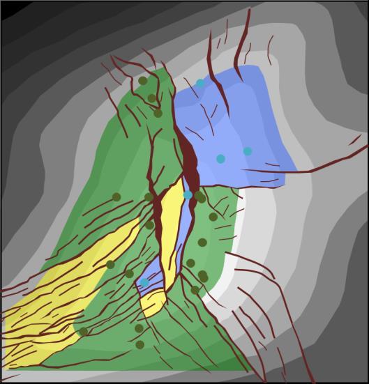
33 Walker and Anderson Figure 1. Frequency of events that impact the understanding of reservoir performance during field development. Figure 2. The Mad Dog top reservoir map has undergone significant changes from before field discovery (top left) through 15 years of seismic acquisition and well results (bottom right). In these maps, green represents known oil; blue is known water; yellow is probably oil; and red is probably water. Circles are well penetrations and brown polygons represent fault heave gaps. Structure is shaded from light (shallow) to dark (deep). 1110
34 Simple and Efficient Representation of Faults and Fault Transmissibility in a Reservoir Simulator Figure 3. Map view and cross-section illustration of the different representation of large faults (black) and smaller faults (grey) in the Mad Dog reservoir grid. TRANSMISSIBILITY The increased number of faults represented as vertical planes in the reservoir model has placed extra significance on the transmissibility modeled on each of the faults. Fault transmissibilities can be calculated in RMS, using fault throw and shale gouge ratio to create a different value at each faulted cell-to-cell contact. However, while these values will be exceedingly precise, they will be precisely wrong, because of the uncertainty inherent in both the seismic interpretation and the population of lithological variations away from well control. Additionally, the complex, varying matrix of values will be difficult for a reservoir engineer to change in order to obtain a better match of production history. Instead we have chosen a simpler approach. We identified 3 categories of faults: Seal, Heavy Baffle, and Light Baffle. Each fault in the field was then assigned to one of these categories based on several criteria. These criteria include throw (larger faults more likely to seal; e.g., Bretan et al., 2003), length-to-throw ratio (faults that are too long for the amount of throw mapped on them are more likely to be composed of several linked faults, and therefore have leak points along them), column height (faults close to the oil-water contact [OWC] are more likely to seal; e.g., Fisher and Jolley, 2007), and orientation relative to the maximum horizontal stress (faults perpendicular to max horizontal stress more likely to seal). We used pressure and compartmentalization information from virgin wells, depleted wells and production interference to determine which faults must seal over geological and production timescales, and assigned those a transmissibility multiplier (TM) of 0 (red on Figure 5). Then we used information from studies of faults cored in the field to determine a range of transmissibilities for the remaining faults (Fig. 6). From this we determined that our Heavy Baffle faults should have a TM of ~0.001 (orange on Figure 5), whereas our Light Baffle fault TMs would be ~0.01 (green on Figure 5). Finally, we know from field observations that faults are surrounded by haloes of deformed rock that generally reduce permeability (e.g. Childs et al., 2009). This is also seen around the 3 faults we have cored in Mad Dog. The distance that these fault damage zones penetrate out into the host rock scales ~1:1 with fault slip, which is 1111
35 Walker and Anderson Figure 4. Triangle diagram from a representative Mad Dog well log colored by shale gouge ratio, illustrating that small faults will not allow the DD sand to communicate with the EE/FF sands, and that the EE and FF will likely have poor connectivity across small faults. difficult to fully implement in a geocellular model with 250 ft long grid cells. Therefore, in addition to the TMs embedded along the fault plane in the model, we reduced the transmissibility of the neighboring grid blocks too, with 0.25 TM in the reference case, and 0.5 and 0.15 in the downside and upside cases respectively. PRESENCE One of the fundamental, long-standing observations about mapping Mad Dog is that the geophysical map of the structure does not explain the well pressure and performance data (Walker et al., 2012). We know that there are more features out there than we can see. As our sedimentological evidence and depositional model suggests the reservoirs are somewhat akin to stacked pancakes, the traditional explanation has been that sub-seismic faults are responsible for compartmentalizing the reservoir beyond what we can see. As our image has improved through the years, we ve been able to identify more faults, and shrink the limits of what is unresolvable. Howev- 1112
36 Simple and Efficient Representation of Faults and Fault Transmissibility in a Reservoir Simulator Figure 5. Transmissibility multipliers used for Mad Dog reservoir modeling reference case. er, we cannot accurately resolve faults with less than ~50 ft of throw in the best-imaged areas of the field and most of the field lies beneath a complex salt body (Walker et al., 2012). From our 30 reservoir penetrations across the field we can estimate that for every fault we can see on seismic, there are at least another 2 faults we cannot see (Fig. 7). Furthermore, our 5 whole cores in the field have unintentionally encountered 3 faults. We increase our fault density based on these observations, and distribute sub-seismic faults throughout the reservoir model following several principles - small faults should be clustered near big faults, with the roughly the same strike; they may be added where a large fault kinks as a vestigial fault tip (e.g., Fig. 8); added faults should be shorter than the shortest mapped fault; they can link faults that come close but do not otherwise touch; and we will add more faults sub-salt than outboard of salt to honor imaging quality. These added faults are generally modeled as Light Baffles using the TM values identified above. RESULTS Using this method we have been able to create a reference case Mad Dog reservoir model that is robust yet flexible. After the reference case model was history matched, we created upside and downside realizations using 1113
37 Walker and Anderson Figure 6. Range of transmissibility multipliers for a sand of 500 md across faults of increasing throw determined from a range of fault permeabilities measured on Mad Dog core samples. the same principles, making faults more transmissible in an upside case and less transmissible in a downside case (Fig. 9). These models were also history matched and used to forecast future production, run economics and allow the identification of key risks and uncertainties, along with our mitigations and contingency plans. The flexibility of the model was recently demonstrated after the results of the first MD2 predrill producer came in with a different amount of depletion than forecast. Using the model we were able to quickly alter the transmissibility of a few distant faults to improve the pressure prediction and update pressure predictions for the next well in the drill sequence to ensure the casing program was still robust, as well as rapidly generate several alternative models to explore other subsurface scenarios. This rapid turnaround would not have been possible with our previous model, demonstrating the value to be found in simple yet efficient models. REFERENCES CITED Brenner, N., 2011, BHP drills sidetracks to extend Mad Dog appraisal: Upstream Magazine, November 25 issue. Bretan, P., G. Yielding, and H. Jones, 2003, Using calibrated shale gouge ratio to estimate hydrocarbon column heights: American Association of Petroleum Geologists Bulletin, v. 87, p Childs, C., T. Manzocchi, J. J. Walsh, C. G. Bonson, A. Nicol, and M. P. G. Schöpfer, 2009, A geometric model of fault zone and fault rock thickness variations: Journal of Structural Geology, v. 31, p Fisher Q. J. and S. J. Jolley, 2007, Treatment of faults in production simulation models, in S. J. Jolley, D. Barr, J. J. Walsh, and R. J. Knipe, eds., Structurally complex reservoirs: Geological Society of London Special Publications, v. 292, p Walker, C. D., P. Belvedere, J. Petersen, S. Warrior, A. Cunningham, G. Clemenceau, C. Huenink, and R. Meltz, 2012, Straining at the leash: Understanding the full potential of the deepwater, sub-salt Mad Dog Field, from appraisal through early production, in N. C. Rosen et al., eds., New understanding of the petroleum systems of continental 1114
38 Simple and Efficient Representation of Faults and Fault Transmissibility in a Reservoir Simulator Figure 7. Example of sub-seismic faulting. A wellbore drilled in the field encounters two seismic faults, both of which can be picked as missing section in the logs. However, detailed dipmeter interpretation reveals an additional 6 faults. Figure 8. Perspective aerial photograph of a linked fault system from the Volcanic Tablelands, California. Vestigial tips, through-going fault, and clustering of small faults near large faults can be seen. Maximum throw on largest fault is ~100 ft. Image is ~3 mi across, with 3x vertical exaggeration. Image courtesy of Google Earth. margins of the world: Proceedings of the 32nd Annual Gulf Coast Section of the Society of Economic Paleontologists and Mineralogists Foundation Bob F. Perkins Research Conference, v. 32, p Walker, C. D., G. A. Anderson, P. G. Belvedere, A. T. Henning, F. O. Rollins, E. Soza, and S. Warrior, 2015, Compartmentalization between the GC0738_1 Mad Dog North wellbores Evidence for post-depositional slumping in the Lower Miocene reservoirs of the deepwater southern Green Canyon, Gulf of Mexico: Gulf Coast Association of Geological Societies Transactions, v. 65, p
39 Walker and Anderson Figure 9. Summary of steps for creating reference case, and upside and downside reservoir models from the seismically-derived map using structural principles. 1116
Quantifying Bypassed Pay Through 4-D Post-Stack Inversion*
 Quantifying Bypassed Pay Through 4-D Post-Stack Inversion* Robert Woock 1, Sean Boerner 2 and James Gamble 1 Search and Discovery Article #40799 (2011) Posted August 12, 2011 *Adapted from oral presentation
Multidisciplinary Approach Unravels Structural Complexities Of Stampede Reservoir
 OCTOBER 2016 The Better Business Publication Serving the Exploration / Drilling / Production Industry Multidisciplinary Approach Unravels Structural Complexities Of Stampede Reservoir By Gopal Mohapatra,
An Overview of the Tapia Canyon Field Static Geocellular Model and Simulation Study
 An Overview of the Tapia Canyon Field Static Geocellular Model and Simulation Study Prepared for Sefton Resources Inc. Jennifer Dunn, Chief Geologist Petrel Robertson Consulting Ltd. Outline Background
Training Venue and Dates Ref # Reservoir Geophysics October, 2019 $ 6,500 London
 Training Title RESERVOIR GEOPHYSICS Training Duration 5 days Training Venue and Dates Ref # Reservoir Geophysics DE035 5 07 11 October, 2019 $ 6,500 London In any of the 5 star hotels. The exact venue
Th C3 08 Capturing Structural Uncertainty in Fault Seal Analysis A Multi-throw Scenario Approach
 Th C3 08 Capturing Structural Uncertainty in Fault Seal Analysis A Multi-throw Scenario Approach M. Giba* (DEA) Summary An intrinsic challenge of fault seal analyses is the large uncertainties that have
Developing the Arundel Field Maximising Hub Value through Seismic Uplift. Chris Hill CNS Geophysicist, BP
 Developing the Arundel Field Maximising Hub Value through Seismic Uplift Chris Hill CNS Geophysicist, BP Arundel Area Introduction Lista Palaeocene Turbidite reservoirs Sands are high productivity with
Evidence for a Hydrodynamic Aquifer in the Lower Miocene Sands of the Mad Dog Field, Gulf of Mexico*
 Evidence for a Hydrodynamic Aquifer in the Lower Miocene Sands of the Mad Dog Field, Gulf of Mexico* Troy A. Dias 1, David L. Tett 1, and Michelle T. Croasdaile 1 Search and Discovery Article #10221 (2010)
Excellence. Respect Openness. Trust. History matching and identifying infill targets using an ensemble based method
 Re-thinking the Goliat reservoir models: Trust History matching and identifying infill targets using an ensemble based method Gjertrud Halset, Reservoir geologist Guro Solberg, Reservoir engineer Respect
Geologic Considerations of Shallow SAGD Caprock; Seal Capacity, Seal Geometry and Seal Integrity, Athabasca Oilsands, Alberta Canada
 Geologic Considerations of Shallow SAGD Caprock; Seal Capacity, Seal Geometry and Seal Integrity, Athabasca Oilsands, Alberta Canada Gordon T. Stabb, Michael Webb Durando Resources Corp, Suncor Energy
Reservoir Scale Deformation and Advances in Fault Seal Analysis
 Reservoir Scale Deformation and Advances in Fault Seal Analysis Tim Needham slide 1 Introduction The answer to the question, Does this fault seal? is It depends This is what It depends on: Juxtaposition
The Alba Field: Improved Reservoir Characterisation using 4D Seismic Data. Elaine Campbell Oliver Hermann Steve Dobbs Andrew Warnock John Hampson
 The Alba Field: Improved Reservoir Characterisation using 4D Seismic Data Elaine Campbell Oliver Hermann Steve Dobbs Andrew Warnock John Hampson Chevron 2005 Alba Field Location Equity: Chevron 23% (operator)
Kachi Onyeagoro, Frans Van der Vlugt, Steve Naruk, Mark Barton & Steve Jolley
 GEOLOGISTS AND RESERVOIR ENGINEERS SHOULD BE FRIENDS!!!! Kachi Onyeagoro, Frans Van der Vlugt, Steve Naruk, Mark Barton & Steve Jolley INTRODUCTION STRUCTURAL AND SIMULATION STRATIGRAPHY AND SIMULATION
Hydrocarbon Volumetric Analysis Using Seismic and Borehole Data over Umoru Field, Niger Delta-Nigeria
 International Journal of Geosciences, 2011, 2, 179-183 doi:10.4236/ijg.2011.22019 Published Online May 2011 (http://www.scirp.org/journal/ijg) Hydrocarbon Volumetric Analysis Using Seismic and Borehole
Estimating Fault Seal and Capillary Sealing Properties in the Visund Field, North Sea A study carried out for Norsk Hydro
 Estimating Fault Seal and Capillary Sealing Properties in the Visund Field, North Sea A study carried out for Norsk Hydro Abstract This study investigates the difference in seal/leakage mechanisms across
Fault History analysis in Move
 Fault History analysis in Move The new Fault History plot in Move provides a method to conduct a quick-look analysis of the evolution of faults through time. By restoring the vertical displacement of a
Fault seal analysis: a regional calibration Nile delta, Egypt
 International Research Journal of Geology and Mining (IRJGM) (2276-6618) Vol. 3(5) pp. 190-194, June, 2013 Available online http://www.interesjournals.org/irjgm Copyright 2013 International Research Journals
Building an Integrated Static Reservoir Model 5-day Course
 Building an Integrated Static Reservoir Model 5-day Course Prepared by International Reservoir Technologies Lakewood, Colorado http://www.irt-inc.com/ 1 Agenda Day 1 Day 2 Day 3 Day 4 Day 5 Morning Introduction
Simplified In-Situ Stress Properties in Fractured Reservoir Models. Tim Wynn AGR-TRACS
 Simplified In-Situ Stress Properties in Fractured Reservoir Models Tim Wynn AGR-TRACS Before the What and the How is Why Potential decrease in fault seal capacity Potential increase in natural fracture
Fault seal analysis in Move
 Fault seal analysis in Move Faults play a critical role in the distribution and accumulation of fluids in sedimentary basins. On the one hand, a fault or fault zone may provide a conduit for fluid migration,
Horizontal well Development strategy
 Horizontal well Development strategy Pakawas Mangkang Team Member Yoseph Partono Stephan Otero Duangdao Chutanukarn Warin Lobtong Suarporn Ketpreechasawat B8/32 Asset, Thailand Chiangmai, 11 th Nov-13
Constrained Fault Construction
 Constrained Fault Construction Providing realistic interpretations of faults is critical in hydrocarbon and mineral exploration. Faults can act as conduits or barriers to subsurface fluid migration and
Bridging Domains - Solution Workflows for Marginal Field Challenges
 Bridging Domains - Solution Workflows for Marginal Field Challenges Gordy Shanor, Geology Domain Leader Schlumberger Information Solutions North Sea GeoMarket Stavanger, Norway Portions Presented previously
Risk Factors in Reservoir Simulation
 Risk Factors in Reservoir Simulation Dr. Helmy Sayyouh Petroleum Engineering Cairo University 12/26/2017 1 Sources Of Data Petro-physical Data Water saturation may be estimated from log analysis, capillary
Pluto 1.5 2D ELASTIC MODEL FOR WAVEFIELD INVESTIGATIONS OF SUBSALT OBJECTIVES, DEEP WATER GULF OF MEXICO*
 Pluto 1.5 2D ELASTIC MODEL FOR WAVEFIELD INVESTIGATIONS OF SUBSALT OBJECTIVES, DEEP WATER GULF OF MEXICO* *This paper has been submitted to the EAGE for presentation at the June 2001 EAGE meeting. SUMMARY
Plumbing the Depths of the Pelican Field
 Plumbing the Depths of the Pelican Field Thurza Frenz Pelican Talk Objectives To discuss the development of the northern area of the Pelican Field, in particular: The relationship between reservoir quality,
OTC OTC PP. Abstract
 OTC OTC-19977-PP Using Modern Geophysical Technology to Explore for Bypassed Opportunities in the Gulf of Mexico R.A. Young/eSeis; W.G. Holt, G. Klefstad/ Fairways Offshore Exploration Copyright 2009,
Downloaded 09/16/16 to Redistribution subject to SEG license or copyright; see Terms of Use at
 Data Using a Facies Based Bayesian Seismic Inversion, Forties Field, UKCS Kester Waters* (Ikon Science Ltd), Ana Somoza (Ikon Science Ltd), Grant Byerley (Apache Corp), Phil Rose (Apache UK) Summary The
Course Title: Discipline: Geology Level: Basic-Intermediate Duration: 5 Days Instructor: Prof. Charles Kluth. About the course: Audience: Agenda:
 Course Title: Structural Geology Discipline: Geology Level: Basic-Intermediate Duration: 5 Days Instructor: Prof. Charles Kluth About the course: This course covers the basic ideas of structural geometry
So I have a Seismic Image, But what is in that Image?
 P-513 So I have a Seismic Image, But what is in that Image? Dr. Nader C. Dutta, Schlumberger Introduction and background Migration involves repositioning of returned signals in a seismic experiment to
Imaging complex structure with crosswell seismic in Jianghan oil field
 INTERPRETER S CORNER Coordinated by Rebecca B. Latimer Imaging complex structure with crosswell seismic in Jianghan oil field QICHENG DONG and BRUCE MARION, Z-Seis, Houston, Texas, U.S. JEFF MEYER, Fusion
F. Bacciotti K. D Amore J. Seguin
 The Role of 4D Seismic Interpretation and Dynamic Modelling in the Successful Drilling of a Late Stage Development Well in the West Brae Field, North Sea F. Bacciotti K. D Amore J. Seguin Introduction
Constraining Uncertainty in Static Reservoir Modeling: A Case Study from Namorado Field, Brazil*
 Constraining Uncertainty in Static Reservoir Modeling: A Case Study from Namorado Field, Brazil* Juliana F. Bueno 1, Rodrigo D. Drummond 1, Alexandre C. Vidal 1, Emilson P. Leite 1, and Sérgio S. Sancevero
Main Challenges and Uncertainties for Oil Production from Turbidite Reservoirs in Deep Water Campos Basin, Brazil*
 Main Challenges and Uncertainties for Oil Production from Turbidite Reservoirs in Deep Water Campos Basin, Brazil* Carlos H. Bruhn 1, Antonio Pinto 1, and Paulo R. Johann 1 Search and Discovery Article
Steve Cumella 1. Search and Discovery Article # (2009) Posted July 30, Abstract
 Posted July 30, Abstract") AV Geology of the Piceance Basin Mesaverde Gas Accumulation* Steve Cumella 1 Search and Discovery Article #110106 (2009) Posted July 30, 2009 *Adapted from oral presentation at AAPG Annual Convention,
AV Geology of the Piceance Basin Mesaverde Gas Accumulation* Steve Cumella 1 Search and Discovery Article #110106 (2009) Posted July 30, 2009 *Adapted from oral presentation at AAPG Annual Convention,
Pore Pressure Predictions in the Challenging Supra / Sub-Salt Exploration Plays in Deep Water, Gulf of Mexico.
 AAPG, 2002, Annual convention, Extended abstract. SHAKER, SELIM*, Geopressure Analysis Services (G.A.S.), Houston TX SMITH, MICHAEL, Mineral Management Service, New Orleans, LA. Pore Pressure Predictions
Opportunities in Oil and Gas Fields Questions TABLE OF CONTENTS
 TABLE OF CONTENTS A. Asset... 3 1. What is the size of the opportunity (size the prize)?... 3 2. Volumetric Evaluation... 3 3. Probabilistic Volume Estimates... 3 4. Material Balance Application... 3 5.
The Deployment of an Azimuthal Resistivity Tool for Geosteering - A Case Study from the Foinaven Field (North Sea)*
*") The Deployment of an Azimuthal Resistivity Tool for Geosteering - A Case Study from the Foinaven Field (North Sea)* Martin Bedrock 1 and Darren Moody 1 Search and Discovery Article #40540 (2010) Posted
The Deployment of an Azimuthal Resistivity Tool for Geosteering - A Case Study from the Foinaven Field (North Sea)* Martin Bedrock 1 and Darren Moody 1 Search and Discovery Article #40540 (2010) Posted
Relinquishment Report
 Relinquishment Report Licence P.089 Block 22/15a 2 nd Round Traditional Licence Award (Operator): 100.0% Disclaimer No representation or warranty, express or implied, is or will be made in relation to
Reservoir Geomechanics and Faults
 Reservoir Geomechanics and Faults Dr David McNamara National University of Ireland, Galway david.d.mcnamara@nuigalway.ie @mcnamadd What is a Geological Structure? Geological structures include fractures
Geohazards have a direct impact on the drilling and
 SPECIAL Geohazards SECTION: G e o h a z a r d s A new, fully integrated method for seismic geohazard prediction ahead of the bit while drilling CENGIZ ESMERSOY, ARTURO RAMIREZ, SHARON TEEBENNY, YANGJUN
Quick Look Interpretation Techniques
 Quick Look Interpretation Techniques Odd Number of Contours A basic rule of contouring is that ALL contours on a continuous surface must close or end at the edge of the map. This rule seems so obvious
Testing of the Strawn Sand, White Hat 20#3, Mustang Prospect, Permian Basin, Texas
 Date: 11 April 2019 ASX Code: WEL Directors John Kopcheff Non-Executive Chairman Neville Henry Managing Director Peter Allchurch Non-Executive Director Larry Liu Non-Executive Director Lloyd Flint Company
SPE DISTINGUISHED LECTURER SERIES is funded principally through a grant of the SPE FOUNDATION
 SPE DISTINGUISHED LECTURER SERIES is funded principally through a grant of the SPE FOUNDATION The Society gratefully acknowledges those companies that support the program by allowing their professionals
Drillworks. DecisionSpace Geomechanics DATA SHEET
 DATA SHEET Drillworks overview DecisionSpace Geomechanics Key features Pre-drill, real-time, and post-drill analyses are all easily performed in one application using the latest data from across the field
Seismic Guided Drilling: Near Real Time 3D Updating of Subsurface Images and Pore Pressure Model
 IPTC 16575 Seismic Guided Drilling: Near Real Time 3D Updating of Subsurface Images and Pore Pressure Model Chuck Peng, John Dai and Sherman Yang, Schlumberger WesternGeco Copyright 2013, International
Evolution of the Geological Model, Lobster Field (Ewing Bank 873)
") Evolution of the Geological Model, Lobster Field (Ewing Bank 873) M.K. Burk, Marathon Oil Company G.L. Brown, Marathon Oil Company D.R. Petro, Marathon Oil Company Throughout the life of a field an accurate
Evolution of the Geological Model, Lobster Field (Ewing Bank 873) M.K. Burk, Marathon Oil Company G.L. Brown, Marathon Oil Company D.R. Petro, Marathon Oil Company Throughout the life of a field an accurate
Applying Stimulation Technology to Improve Production in Mature Assets. Society of Petroleum Engineers
 Applying Stimulation Technology to Improve Production in Mature Assets Alexandr Mocanu Well Production Services, Schlumberger Visegrád, 19 November 2015 Society of Petroleum Engineers 1 Agenda Formation
Downloaded 10/02/18 to Redistribution subject to SEG license or copyright; see Terms of Use at
 Multi-scenario, multi-realization seismic inversion for probabilistic seismic reservoir characterization Kester Waters* and Michael Kemper, Ikon Science Ltd. Summary We propose a two tiered inversion strategy
Tim Carr - West Virginia University
 Tim Carr - West Virginia University Role of Geology in Field Development Develop static geological model of the reservoir(s) Analyze relevant geoscience and engineering data, integrate them into model
Osareni C. Ogiesoba and Angela K. Eluwa. Bureau of Economic Geology, University of Texas at Austin, Burnet Rd., Austin Texas 78759
 Structural Styles of Eocene Jackson and Oligocene Vicksburg Formations within the Rio Grande and Houston Embayments near the San Marcos Arch, Refugio and Calhoun Counties, South Texas Gulf Coast Osareni
Hydrocarbon Potential of the Marginal Fields in Niger Delta Oza Field, a case study*
 Hydrocarbon Potential of the Marginal Fields in Niger Delta Oza Field, a case study* J.N. Sahu 1, C.H.V. Satya Sai 1, V. Chintamani 1 and C. Vishnu Vardhan 1 Search and Discovery Article #20182 (2012)*
Trapping Mechanisms along North Similan and Lanta Trends, Pattani Basin, Gulf of Thailand
 Trapping Mechanisms along North Similan and Lanta Trends, Pattani Basin, Gulf of Thailand Piyaporn Aukkanit Petroleum Geoscience Program, Department of Geology, Faculty of Science, Chulalongkorn University,
The Kingfisher Field, Uganda - A Bird in the Hand! S R Curd, R Downie, P C Logan, P Holley Heritage Oil plc *
 A Bird in the Hand! EXTENDED ABSTRACT The Kingfisher Field, Uganda - A Bird in the Hand! Heritage Oil plc * The Kingfisher Field lies on Uganda s western border beneath Lake Albert, situated in the western
Quantitative evaluation of fault lateral sealing
 IOSR Journal of Engineering (IOSRJEN) ISSN (e): 2250-3021, ISSN (p): 2278-8719 Vol. 06, Issue 03 (March. 2016), V1 PP 29-33 www.iosrjen.org Jianan Zhu 1, Yue Gong 1 1 (College of Earth Sciences, Northeast
JP Morgan Oil Seminar Sydney, Australia May 2, 2003
 JP Morgan Oil Seminar Sydney, Australia May 2, 2003 The Future of the Gulf of Mexico and BHP Billiton s Position Bernie Wirth - Vice President, Exploration and Appraisal Gulf of Mexico Outline Explain
Source Body Migration, an Approximate Inversion Method for Full Tensor Gravity Gradiometer Data
 Source Body Migration, an Approximate Inversion Method for Full Tensor Gravity Gradiometer Data James Brewster, Alan Morgan, and John Mims * Bell Geospace Inc., 400 N. Sam Houston Pkwy E., Ste. 325, Houston,
PETROLEUM GEOSCIENCES GEOLOGY OR GEOPHYSICS MAJOR
 PETROLEUM GEOSCIENCES GEOLOGY OR GEOPHYSICS MAJOR APPLIED GRADUATE STUDIES Geology Geophysics GEO1 Introduction to the petroleum geosciences GEO2 Seismic methods GEO3 Multi-scale geological analysis GEO4
For personal use only
 Date: 18 February 2019 ASX Code: WEL Directors John Kopcheff Non-Executive Chairman Neville Henry Managing Director Peter Allchurch Non-Executive Director James Hodges Non-Executive Director Larry Liu
Bulletin of Earth Sciences of Thailand. Evaluation of the Petroleum Systems in the Lanta-Similan Area, Northern Pattani Basin, Gulf of Thailand
 Evaluation of the Petroleum Systems in the Lanta-Similan Area, Northern Pattani Basin, Gulf of Thailand Sirajum Munira Petroleum Geoscience Program, Department of Geology, Faculty of Science, Chulalongkorn
Best practices predicting unconventional reservoir quality
 Introduction Best practices predicting unconventional reservoir quality Cristian Malaver, Michel Kemper, and Jorg Herwanger 1 Unconventional reservoirs have proven challenging for quantitative interpretation
EAS 233 Geologic Structures and Maps Winter Miscellaneous practice map exercises. 1. Fault and separation:
 Miscellaneous practice map exercises 1. Fault and separation: With respect to Map 1, what are (a) the orientation of the fault, and (b) the orientation of bedding in the units cut by the fault. (c) Mark
Serial Cross-Section Trishear Modeling: Reconstructing 3-D Kinematic Evolution of the Perdido Fold Belt*
 Serial Cross-Section Trishear Modeling: Reconstructing 3-D Kinematic Evolution of the Perdido Fold Belt* Dian He 1 and John Paul Brandenburg 2 Search and Discovery Article #30313 (2014)** Posted January
Update - Testing of the Strawn Sand, White Hat 20#3, Mustang Prospect, Permian Basin, Texas
 Date: 15 April 2019 ASX Code: WEL Directors John Kopcheff Non-Executive Chairman Neville Henry Managing Director Peter Allchurch Non-Executive Director Larry Liu Non-Executive Director Lloyd Flint Company
NORTHEAST EL HAMD BLOCK
 NORTHEAST EL HAMD BLOCK NORTHEAST EL HAMD BLOCK LOCATION : The block is locating in the eastern side of the central part of the Gulf of Suez basin west and south of Belayim fields. NORTHEAST EL HAMD BLOCK
High Resolution Field-based Studies of Hydrodynamics Examples from the North Sea
 High Resolution Field-based Studies of Hydrodynamics Examples from the North Sea Stephen O Connor 1, Richard Swarbrick 2 and Sam Green 1 1 Ikon GeoPressure, Durham, UK 2 Swarbrick Geopressure Consultancy,
Salt Geology and New Plays in Deep-Water Gulf of Mexico* By Abu Chowdhury 1 and Laura Borton 1
 Salt Geology and New Plays in Deep-Water Gulf of Mexico* By Abu Chowdhury 1 and Laura Borton 1 Search and Discovery Article #10131 (2007) Posted August 25, 2007 *Adapted from extended abstract prepared
MUDLOGGING, CORING, AND CASED HOLE LOGGING BASICS COPYRIGHT. Coring Operations Basics. By the end of this lesson, you will be able to:
 LEARNING OBJECTIVES MUDLOGGING, CORING, AND CASED HOLE LOGGING BASICS Coring Operations Basics By the end of this lesson, you will be able to: Understand why cores are justified and who needs core data
Pressure Regimes in Deep Water Areas: Cost and Exploration Significance Richard Swarbrick and Colleagues Ikon GeoPressure, Durham, England
 Pressure Regimes in Deep Water Areas: Cost and Exploration Significance Richard Swarbrick and Colleagues Ikon GeoPressure, Durham, England FINDING PETROLEUM 26 th September 2012 OUTLINE of PRESENTATION
Subsurface Geology and Resource Exploration
 LAB 11. Subsurface Geology and Resource Exploration Locating earth resources such as aluminum, copper, gold and gemstones has been an important job for geologists for a long time. This lab deals with the
Interaction between Faults and Igneous Intrusions in Sedimentary Basins: Insights from 3D Seismic Reflection Data*
 Interaction between Faults and Igneous Intrusions in Sedimentary Basins: Insights from 3D Seismic Reflection Data* Craig Magee¹, Christopher A. Jackson¹, and Nick Schofield² Search and Discovery Article
A013 HISTORY MATCHING WITH RESPECT TO RESERVOIR STRUCTURE
 A3 HISTORY MATCHING WITH RESPECT TO RESERVOIR STRUCTURE SIGURD IVAR AANONSEN ; ODDVAR LIA ; AND OLE JAKOB ARNTZEN Centre for Integrated Research, University of Bergen, Allégt. 4, N-7 Bergen, Norway Statoil
Identified a possible new offset location where the customer is currently exploring drill options.
 GroundMetrics was hired to conduct a Full-Field Resistivity Survey for an oil and gas producer that needed to make crucial decisions to drive profitability at the location. The results saved them hundreds
GeothermEx, Inc. GEOTHERMAL RESERVOIR ASSESSMENT METHODOLOGY FOR THE SCIENTIFIC OBSERVATION HOLE PROGRAM, KILAUEA EAST RIFT ZONE, HAWAII TASK 1 REPORT
 (415) 527 9876 CABLE ADDRESS- GEOTHERMEX TELEX 709152 STEAM UD FAX (415) 527-8164 Geotherm Ex, Inc. RICHMOND. CALIFORNIA 94804-5829 GEOTHERMAL RESERVOIR ASSESSMENT METHODOLOGY FOR THE SCIENTIFIC OBSERVATION
Relinquishment Report. Block 48/11c
 Relinquishment Report Petroleum Production Licence No. P.1008 Block 48/11c EOG Resources United Kingdom Limited List of Contents 1. Licence information 2. Synopsis 3. Exploration Activities 4. Prospectivity
TECHNICAL STUDIES. rpsgroup.com/energy
 TECHNICAL STUDIES RPS Energy - a global energy consultancy RPS Energy is part of the RPS Group plc, a FTSE 250 company with an annual turnover of $700m and over 4700 employees. As one of the world s leading
Reservoir Management Background OOIP, OGIP Determination and Production Forecast Tool Kit Recovery Factor ( R.F.) Tool Kit
 Tool Kit") Reservoir Management Background 1. OOIP, OGIP Determination and Production Forecast Tool Kit A. Volumetrics Drainage radius assumption. B. Material Balance Inaccurate when recovery factor ( R.F.) < 5 to
Reservoir Management Background 1. OOIP, OGIP Determination and Production Forecast Tool Kit A. Volumetrics Drainage radius assumption. B. Material Balance Inaccurate when recovery factor ( R.F.) < 5 to
How fast can a falcon fly?
 How fast can a falcon fly? DEVEX 9 th May 2012 Peter Brand Overview Overview Timeline Appraisal Development Performance Potential Summary / Conclusions Overview - Location Falcon Tern Kestrel Shetland
Robust Appraisal Planning Link Between Discovered Resource and Field Development
 Robust Appraisal Planning Link Between Discovered Resource and Field Development Kolade Adeleye June, 2016 NAPE TECHNICAL MEETING Outline Introduction Business case for an appraisal program Scope of an
Distinguished Lecturer David A. Ferrill. Sponsored by AAPG Foundation
 Distinguished Lecturer David A. Ferrill Sponsored by AAPG Foundation AAPG Membership Information Benefits: Monthly Receipt of AAPG Explorer & AAPG Bulletin Discounts on Books and Other Publications Registration
Downloaded 09/16/16 to Redistribution subject to SEG license or copyright; see Terms of Use at
 Ehsan Zabihi Naeini*, Ikon Science & Russell Exley, Summit Exploration & Production Ltd Summary Quantitative interpretation (QI) is an important part of successful Central North Sea exploration, appraisal
MITIGATE RISK, ENHANCE RECOVERY Seismically-Constrained Multivariate Analysis Optimizes Development, Increases EUR in Unconventional Plays
 White Paper MITIGATE RISK, ENHANCE RECOVERY Seismically-Constrained Multivariate Analysis Optimizes Development, Increases EUR in Unconventional Plays SM Seismically-Constrained Multivariate Analysis Optimizes
X,800. X,850 ft. X,900 ft. X,950 ft. X,000 ft. GeoSphere. Reservoir Mapping-While-Drilling Service
 X,800 X,850 ft X,900 ft X,950 ft X,000 ft GeoSphere Reservoir Mapping-While-Drilling Service Discover reservoir mapping-while-drilling...... and reveal subsurface beddings and fluid contacts at the reservoir
Serica Energy (UK) Limited. P.1840 Relinquishment Report. Blocks 210/19a & 210/20a. UK Northern North Sea
 Limited. P.1840 Relinquishment Report. Blocks 210/19a & 210/20a. UK Northern North Sea") Serica Energy (UK) Limited P.1840 Relinquishment Report Blocks 210/19a & 210/20a UK Northern North Sea January 2013 1 Header Licence: P.1840 Round: Licence Type: 26th Round Traditional "Drill-or-Drop"
Serica Energy (UK) Limited P.1840 Relinquishment Report Blocks 210/19a & 210/20a UK Northern North Sea January 2013 1 Header Licence: P.1840 Round: Licence Type: 26th Round Traditional "Drill-or-Drop"
Comparison of Reservoir Quality from La Luna, Gacheta and US Shale Formations*
 Comparison of Reservoir Quality from La Luna, Gacheta and US Shale Formations* Joel Walls 1 and Elizabeth Diaz 2 Search and Discovery Article #41396 (2014) Posted July 24, 2014 *Adapted from oral presentation
J.V. Herwanger* (Ikon Science), A. Bottrill (Ikon Science) & P. Popov (Ikon Science)
, A. Bottrill (Ikon Science) & P. Popov (Ikon Science)") 29829. One 4D geomechanical model and its many applications J.V. Herwanger* (Ikon Science), A. Bottrill (Ikon Science) & P. Popov (Ikon Science) Main objectives (i) Field case study demonstrating application
29829. One 4D geomechanical model and its many applications J.V. Herwanger* (Ikon Science), A. Bottrill (Ikon Science) & P. Popov (Ikon Science) Main objectives (i) Field case study demonstrating application
Seals and CO 2 : Techniques and Issues. Dave Dewhurst CSIRO Petroleum
 Seals and CO 2 : Techniques and Issues Dave Dewhurst CSIRO Petroleum Why do Seals Fail? Capillary Failure Buoyancy Pressure > Capillary Entry Pressure Mechanical Failure Fracturing (tensile/shear) Faulting
Relinquishment Report. Licence P2016 Block 205/4c
 Relinquishment Report Licence P2016 Block 205/4c September 2016 JX Nippon Exploration and Production (U.K.) Limited Idemitsu Petroleum UK Ltd. Table of Contents 1. Licence Information... 1 2. Licence Synopsis...
Locating the Remaining Oil in a Complex Field: The Pierce Field Redevelopment
 Locating the Remaining Oil in a Complex Field: The Pierce Field Redevelopment Presenter: Michael Porter Team: David Bateman, Thaddeus Ehighebolo, Fiona Haldane, Ash Holland, Jackie Kechichian & Ewan Robertson
5 ORIGINAL HYDROCARBONS IN PLACE
 5 ORIGINAL HYDROCARBONS IN PLACE The deterministic estimation of oil in place for the White Rose Field was completed using 3-D geological modelling in the RMS software package. This procedure involves
QUANTITATIVE INTERPRETATION
 QUANTITATIVE INTERPRETATION THE AIM OF QUANTITATIVE INTERPRETATION (QI) IS, THROUGH THE USE OF AMPLITUDE ANALYSIS, TO PREDICT LITHOLOGY AND FLUID CONTENT AWAY FROM THE WELL BORE This process should make
Bulletin of Earth Sciences of Thailand. A study of Reservoir Connectivity in the Platong Field, Pattani Basin, Gulf of Thailand. Hathairat Roenthon
 A study of Reservoir Connectivity in the Platong Field, Pattani Basin, Gulf of Thailand Hathairat Roenthon Petroleum Geoscience Program, Department of Geology, Faculty of Science, Chulalongkorn University,
SPE DISTINGUISHED LECTURER SERIES is funded principally through a grant of the SPE FOUNDATION
 SPE DISTINGUISHED LECTURER SERIES is funded principally through a grant of the SPE FOUNDATION The Society gratefully acknowledges those companies that support the program by allowing their professionals
Storage 6 - Modeling for CO 2 Storage. Professor John Kaldi Chief Scientist, CO2CRC Australian School of Petroleum, University of Adelaide, Australia
 Storage 6 - Modeling for CO 2 Storage Professor John Kaldi Chief Scientist, CO2CRC Australian School of Petroleum, University of Adelaide, Australia Regina, Sask., Canada, 17-22 July, 2016 Modeling 2 What
Integrating rock physics and full elastic modeling for reservoir characterization Mosab Nasser and John B. Sinton*, Maersk Oil Houston Inc.
 Integrating rock physics and full elastic modeling for reservoir characterization Mosab Nasser and John B. Sinton*, Maersk Oil Houston Inc. Summary Rock physics establishes the link between reservoir properties,
DHI Analysis Using Seismic Frequency Attribute On Field-AN Niger Delta, Nigeria
 IOSR Journal of Applied Geology and Geophysics (IOSR-JAGG) e-issn: 2321 0990, p-issn: 2321 0982.Volume 1, Issue 1 (May. Jun. 2013), PP 05-10 DHI Analysis Using Seismic Frequency Attribute On Field-AN Niger
One or two deficiencies of current fault seal analysis methods
 Shell Exploration & Production One or two deficiencies of current fault seal analysis methods Scott J. Wilkins and Stephen J. Naruk Copyright 2003 SIEP B.V. Structure, Traps and Seals Team Bellaire Technology
P026 Outcrop-based reservoir modeling of a naturally fractured siliciclastic CO 2 sequestration site, Svalbard, Arctic Norway
 P026 Outcrop-based reservoir modeling of a naturally fractured siliciclastic CO 2 sequestration site, Svalbard, Arctic Norway K. Senger (University of Bergen / CIPR), K. Ogata* (University Centre in Svalbard),
Mapping Faults With Lightning, Natural-Sourced Electromagnetics (NSEM) Louis J. Berent Dynamic Measurement, LLC
 Louis J. Berent Dynamic Measurement, LLC") Mapping Faults With Lightning, Natural-Sourced Electromagnetics (NM) Louis J. Berent Dynamic Measurement, LLC 23 June 2015 Validating NM with 2-D Resistivity Imaging Profiling & Ground Penetrating Radar
Mapping Faults With Lightning, Natural-Sourced Electromagnetics (NM) Louis J. Berent Dynamic Measurement, LLC 23 June 2015 Validating NM with 2-D Resistivity Imaging Profiling & Ground Penetrating Radar
ISSN Online: X ISSN Print: Shale Gas Potential in Pakistan: By comparison of Sembar formation and Barnett Shale Texas
 Journal of Electrical Power & Energy Systems, 2018, 2(9), 19-25 http://www.hillpublisher.com/journals/jepes/ ISSN Online: 2576-053X ISSN Print: 2576-0521 Shale Gas Potential in Pakistan: By comparison
Storage 4 - Modeling for CO 2 Storage. Professor John Kaldi Chief Scientist, CO2CRC Australian School of Petroleum, University of Adelaide, Australia
 Storage 4 - Modeling for CO 2 Storage Professor John Kaldi Chief Scientist, CO2CRC Australian School of Petroleum, University of Adelaide, Australia 1 Modelling 2 On Models. All models are wrong. some