The 2011 Magnitude 9.0 Tohoku-Oki Earthquake: Mosaicking the Megathrust from Seconds to Centuries
|
|
|
- Jacob Day
- 6 years ago
- Views:
Transcription
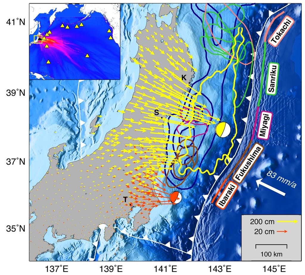
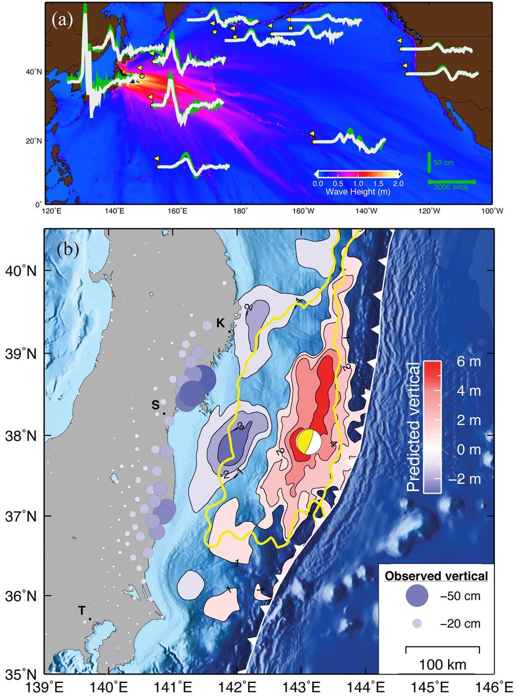
1 The 2011 Magnitude 9.0 Tohoku-Oki Earthquake: Mosaicking the Megathrust from Seconds to Centuries Mark Simons, 1 * Sarah E. Minson, 1 Anthony Sladen, 1,2 Francisco Ortega, 1 Junle Jiang, 1 Susan E. Owen, 3 Lingsen Meng, 1 Jean- Paul Ampuero, 1 Shengji Wei, 1 Risheng Chu, 1 Donald V. Helmberger, 1 Hiroo Kanamori, 1 Eric Hetland, 4 Angelyn W. Moore, 3 Frank H. Webb 3 1 Seismological Laboratory, Division of Geological and Planetary Sciences, California Institute of Technology, Pasadena, CA 91125, USA. 2 Geoazur, Observatoire de la Côte d Azur, Université de Nice Sophia Antipolis, CNRS, IRD, Valbonne, Nice Cedex 2, France. 3 Jet Propulsion Laboratory, California Institute of Technology, Pasadena, CA 91109, USA. 4 Department of Geological Sciences, University of Michigan, Ann Arbor, MI 48109, USA. *To whom correspondence should be addressed. simons@caltech.edu Geophysical observations from the 2011 M w 9.0 Tohoku- Oki, Japan earthquake allow exploration of a rare large event along a subduction megathrust. Models for this event indicate that the distribution of coseismic fault slip exceeded 50 m in places. Sources of high-frequency seismic waves delineate the edges of the deepest portions of coseismic slip and do not simply correlate with the locations of peak slip. Relative to the M w Maule, Chile earthquake, the Tohoku-Oki earthquake was deficient in high-frequency seismic radiation a difference that we attribute to its relatively shallow depth. Estimates of total fault slip and surface secular strain accumulation on millennial time scales suggest the need to consider the potential for a future large earthquake just south of this event. The 2011 Tohoku-Oki earthquake occurred on the megathrust where the Pacific Plate subducts below Japan at an average rate of about 8 to 8.5 cm/yr (Fig. 1) (1). Historically, many M w 7 to M w 8 earthquakes have occurred on the Japan Trench megathrust (2). Geodetic observations of crustal strain during the interseismic period have been used to infer spatial variations in the degree of plate coupling (i.e., regions of the megathrust expected to produce large earthquakes) for this section of the Japan Trench (3). Generally, these models infer high coupling in regions where earthquakes were known to have already occurred (Fig. 1 and fig. S1) with only partial or even no coupling from the trench to a point approximately midway between the trench and the coastline precisely the region where the 2011 Tohoku-Oki earthquake occurred. It is fundamentally difficult to use land-based data to assess the state of coupling on distant portions of a megathrust. Historically, the Jogan earthquake of July 13, 869 AD may be the only documented event to have occurred with a possible magnitude and location similar to that of the 2011 earthquake (4). Observations of the 2011 Tohoku-Oki earthquake from a dense regional geodetic network and globally distributed broadband seismographic networks, as well as open ocean tsunami data, allow the construction of a family of models that describe the distribution and evolution of subsurface fault slip. Surface displacements due to the Tohoku-Oki earthquake were observed by over 1,200 continuously recording GPS sites installed and operated by the Geodetic Survey of Japan (GSI). Here, we use data sampled at 5 min intervals to produce individual three-component positional time series from which we isolate coseismic displacements (Fig. 1) (5). Significant quasi-permanent displacements due to the mainshock occurred over the entire northern half of Honshu, with peak GPS-measured offsets exceeding 4.3 m horizontally and 66 cm of subsidence (Figs. 1 and 2). We also isolate surface displacements associated with an M w 7.9 aftershock that occurred about 30 min after the mainshock (Fig. 1). The spatial extent and the azimuth of the horizontal displacement vectors, indicate that the aftershock was located to the south of the mainshock in the Ibaraki segment. Peak horizontal GPS-measured displacements for this aftershock are approximately 44 cm (Fig. 1). We constrain the distribution of coseismic slip on the shallowest portions of the megathrust using observations of open ocean tsunami wave heights measured by deep sea-bottom pressure gauges (Fig. 1). Based on their spatial and azimuthal distribution, we selected 12 sensors in the Pacific ocean east of the Japan trench. The closest of these pressure gauges detected a maximum tsunami wave height of more than 1.9 m (Fig. 2A). We first describe static coseismic slip models based on the GPS observations of coseismic offsets and the seafloor pressure gauge data (Fig. 3 and fig. S2). Static models constrain the final distribution of slip for the event but not its temporal evolution. We adopt a novel fully Bayesian probabilistic formalism requiring no a priori spatial regularization (5, 6). We conservatively define the section of / / 19 May 2011 / Page 1 / /science
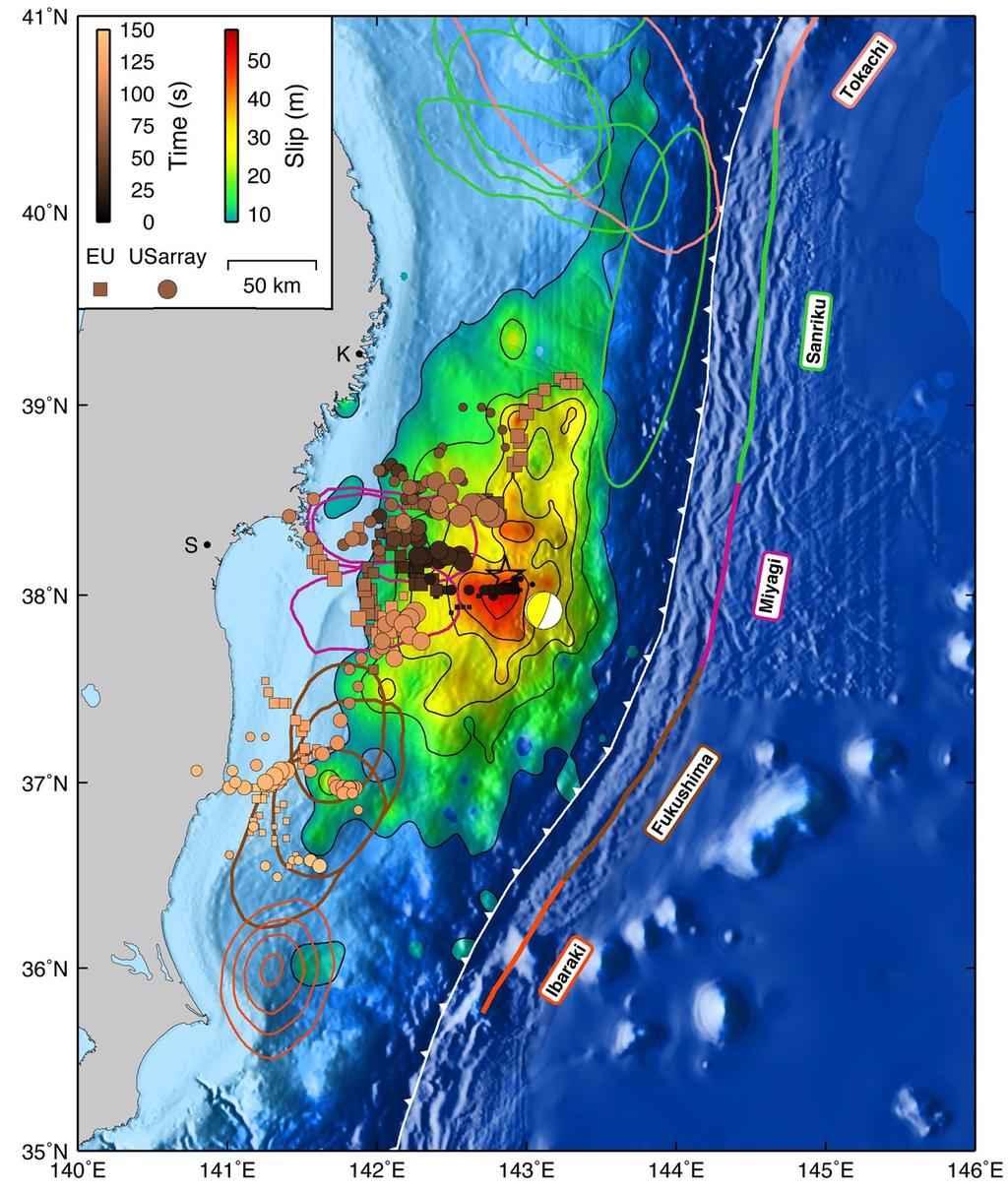
2 the megathrust directly involved with the earthquake by considering only the areas where inferred slip exceeds 8 m (approximately 15% of the maximum slip value depending on the model). The model predicts maximum seafloor subsidence of about 2 m located 50 km offshore Sendai and Kamaishi, and maximum seafloor uplift just under 9 m about 50 km from the trench (Fig. 2). This model fits the GPS and tsunami data with variance reductions of 99.7% and 90.1%, respectively. Residual GPS displacements after removal of the model predictions are shown in fig. S3. The spatial distribution of slip (Fig. 3) can be divided into several sections. The central section contains the highest estimated slip values with peak displacement of around 60 m. The up-dip limit of the forearc is an active accretionary prism that extends about 50 km landwards of the trench. Generally, the majority of the fault slip does not extend below this zone, with the exception being just up-dip of the region of maximum fault slip where estimated slip values near the trench range from about 5 to 15 m. A tendril of slip extends over 100 km north from the central slip zone and just downdip from the inferred source of the 1896 M w 8.0 Sanriku earthquake. Average slips in this region are approximately 5 to 10 m similar to those inferred for the 1896 earthquake (7). A lobe of about 10 m of fault slip extends down-dip toward the Oshika Peninsula east-northeast of Sendai. This lobe overlaps a couple of the inferred historical Miyagi-Oki rupture areas. Slip in the up-dip portion of these rupture areas exceeds 20 m. Another tendril of significant slip (5 to 10 m) extends southwards of the main high slip asperity. This tendril clearly overlaps the inferred locations of the 1938 Fukushima earthquake sequence. We estimated probability distributions for derived scalar rupture quantities including rupture area, potency, scalar seismic moment, and static stress drop (fig. S4). Estimates of moment magnitude range from 8.8 to 9.2. We note that static slip models are relatively insensitive to absolute scaling of the elastic moduli, thus estimates of moment are less certain than estimates of potency. Estimates of static stress drop vary between 2 and 10 MPa depending on the area of fault considered. These values are high relative to previous estimates for megathrust events, which typically lie in the 1 to 5 MPa range (8) and reflect the relatively small area over which there is high slip. As a point of comparison, models of the 2010 M w 8.8 Maule, Chile earthquake typically find twice the along-strike extent of slip and half the peak slip as our model for the Tohoku-Oki event (9, 10). We also developed two kinematic finite fault models incorporating one and two fault planes, respectively, broadband seismic data, and GPS observations, but no tsunami data (5, 11). Examples of the displacement and velocity waveform fits are shown in fig. S5. The inferred moment rate function suggests that most of the rupture occurred in a little over 3 min (fig. S6). We find a low average rupture velocity of about 1.2 km/s (fig. S6). This model explains 99% of the variance of the GPS data. The peak estimated fault slip in this model is about 45 m, a little less than found in the static model. This difference is due to the imposed smoothing in the kinematic model, which is absent in the static model. The extension of slip to the south (offshore Fukushima) is evident in the kinematic model; however, it is located up-dip relative to the static model, presumably due to the absence of the tsunami constraints in the kinematic model. The M w 7.9 aftershock occurred just beyond the southernmost extent of the mainshock slip area with an estimated maximum slip of about 4 m for this event (Fig. 3) (5). Observations at the high-frequency (HF) end of the seismic spectrum (2 to 4 Hz) can constrain rupture direction and duration (12). 90% of the energy release in this frequency band occurs within about 3 min (fig. S7). Unilateral rupture propagation would result in an azimuthally dependent duration. This earthquake displays uniform durations at most azimuths with slightly shortened durations in the down-dip direction, suggesting bilateral along-strike rupture with some down-dip propagation (fig. S7). We developed an image of the rupture process at high frequencies (between 0.5 and 1 Hz) using back-projection of teleseismic array waveforms (13) based on high-resolution array processing techniques (5, 14, 15). The most energetic of the high-frequency sources as a function of time during the rupture are systematically down-dip of the regions of largest fault slip (Fig. 3). The robustness of the locations of the HF radiators relative to the assumed hypocenter is supported by the consistency between the results obtained with USArray data and those from the European array (Fig. 3 and fig. S8). HF radiation is usually assumed to be spatially correlated to seismic slip (16) or uniformly distributed over the fault (17). This assumption contrasts with the spatial complementarity between HF and low frequency (LF) source properties observed for this earthquake. Such a relationship has been inferred for other earthquakes, although not systematically (18), and might reflect the general lack of correlation between HF and LF in ground motions (19, 20). Dynamic rupture models generate HF radiation mostly during sudden changes of rupture speed along sharp contrasts of fault rheology or geometry, or along remnant stress concentrations from previous earthquakes (21), which can define the boundaries of the slip area. Instead of relying on characteristics of the rupture dynamics to explain the predominance of HF radiators downdip of the region of significant coseismic slip, an alternative explanation is that they occur at the transition between brittle and ductile regions. Recent observations of medium-sized earthquakes down-dip from aseismic sections as well as of / / 19 May 2011 / Page 2 / /science
3 slow-slip and non-volcanic tremor phenomena suggest the presence of frictional heterogeneities in the brittle-ductile transition regions of subduction megathrusts (22). Coseismic triggering of compact brittle asperities embedded in the ductile fault matrix could explain the relative locations of HF and lower frequency slip and the apparent lack of HF radiators at shallow depths. Similarly, we find that large aftershocks with thrust mechanisms are located outside the region of coseismic slip (fig. S2), as has been documented for previous events (23, 24). Interestingly, for this event, aftershocks are dominantly down-dip of the regions of major coseismic slip consistent with the idea that fault slip at shallow depths is relatively slow due to higher fracture energy and thus radiates energy less efficiently than at greater depths (8). This latter interpretation is supported by a comparison of seismic excitation between 0.5 and 4 Hz from the 2010 Maule and 2011 Tohoku-Oki events (fig. S9). While the value of peak slip inferred for the Tohoku-Oki earthquake was about 2 to 3 times larger than for the Maule earthquake and the area of appreciable slip for the Tohoku-Oki is approximately half that of the Maule earthquake, we find that the former produced much less HF radiation. We suggest that this difference is due to the fact that the Maule earthquake rupture is on average much deeper than the Tohoku-Oki rupture (fig. S10). Thus, it may be that shallow ruptures generally produce large displacements with relatively weak HF excitation. Such an interpretation is also broadly consistent with the general observations that tsunami earthquakes rupture very slowly with slip concentrated in the shallowest part of the megathrust (25). Our inferred fault slip model suggests high static stress drop with large amounts of slip in a small region. An explanation for this behavior theorizes the existence of barriers that require much more stress accumulation than other regions before they rupture. Such barriers may pin the fault locally, limiting the amount of seismic slip occurring on neighboring areas that have lower thresholds for failure. When the strongest barrier finally ruptures, then surrounding areas can catch up. Subducted seamounts are the most obvious candidates for such barriers (26). Indeed, several seamounts are known to have subducted in this segment of the Japan Trench (27). The distribution of slip in the Tohoku- Oki earthquake suggests that small areas can have high effective yield stresses that serve to limit rupture propagation during some earthquakes but then eventually rupture with large slip during others. The extent to which the 2011 earthquake was unexpected suggests that we should consider the potential for similar large events elsewhere on the Japan Trench megathrust. The secular interseismic velocity field for the Miyagi segment shows over 3 cm/yr of relative convergence across Honshu (Fig. 4). On average, faults in the interior and off the western coast of Honshu, are believed to account for between 1 and 2 cm/yr (28) leaving 1 to 2 cm/yr associated with interseismic strain accumulation on the subduction interface. We adopt 1,100 years as a representative time period because this corresponds to the last large event that is inferred to have occurred in this region (4). Thus, over this time period, we must still account for 11 to 22 m of relative motion across Honshu. Similarly, at about 8.5 cm/yr of convergence, we must account for over 90 m of fault slip on the megathrust. Earthquake activity offshore of Miyagi (Fig. 1) has been suggested to be dominated by M7+ earthquakes recurring every 30 to 40 years (2). However, it has already been established that the historical events are not exact repeats of one another (29). Further, such M7+ events only produce 3 to 4 m of fault slip and 5 to 20 cm of surface displacement per event. In the 2011 mainshock, fault slip in the region of the historical M7+ events ranged from 5 to 25 m, suggesting that the concept of a characteristic subduction earthquake with approximately the same slip per event at a given location may be of limited use (30). That the 2011 event produced approximately 50 m of slip up-dip of the historical Miyagi M7+ events is roughly consistent with a 500 to 1,000 year potential slip accumulation period. However, there is no basis on which to assume that the aforementioned interval of 1,100 years is representative of the recurrence interval of great earthquakes in this segment it could be shorter by a factor of two and still be consistent with the surface displacement budget and the peak slip inferred in this recent earthquake. The only previously recorded large events offshore Fukushima and Ibaraki occurred as a sequence in 1938, which taken together correspond to about an M w 8.1 event (31). At about 8.0 cm/yr convergence, the 73 years since those earthquakes imply about 6 m of accumulated potential fault slip surprisingly similar to the estimates of fault slip for this region during the 2011 event. However, this agreement is probably coincidental since there is no record of an equivalent set of earthquakes preceding the 1938 sequence. Similarly, the 2011 M w 7.9 aftershock offshore of Ibaraki (Fig. 1) produced about 4 m of fault slip, implying a 50 year recurrence if these events are characteristic of this segment of the megathrust. There is no documentation of large (M8+) events prior to 1938 (31). The 2 cm/yr GPS-observed onshore convergence in this region (Fig. 4) implies that, in terms of the 1,100 year budget, there is between 0 and 10 m of surface convergence that cannot be plausibly associated with faults farther to the west (28). The combination of the 2011 mainshock and the M7.9 aftershock only produced about 2 m of surface displacement. There is no record of a large event up-dip of the 1938 Fukushima and Ibaraki sequence. Thus, the slip budget on the megathrust and the surface velocity data suggest that an / / 19 May 2011 / Page 3 / /science
4 earthquake similar to the 2011 event is possible offshore Ibaraki and Fukushima just south of the most recent event (Fig. 4). During such an event, the 1938 asperities and the M7.9 aftershock rupture area could experience much greater slip than has been documented for previous events, similar to what just occurred offshore Miyagi. However, if this region is in fact not strongly coupled, simple mechanical models (32) would predict high rates of post-seismic afterslip as is inferred to have occurred after several large recent earthquakes (24). Thus, it is essential to monitor this region to quantify the extent of any post-seismic slip in order to further understand the long-term fault slip budget and associated seismic hazard. References and Notes 1. C. DeMets, R. G. Gordon, D. F. Argus, Geophys. J. Int. 181, 1 (2010). 2. Seismic Activity in Japan Regional Perspectives on the Characteristics of Destructive Earthquakes (Excerpt) (Earthquake Research Committee, Headquarters for Earthquake Research Promotion, Prime Minister s Office, Tokyo, 1998). 3. C. Hashimoto, A. Noda, T. Sagiya, M. Matsu ura, Nat. Geosci. 2, 141 (2009). 4. K. Minoura, F. Imamura, D. Sugawara, Y. Kono, T. Iwashita, J. Natural Disaster Sci. 23, 83 (2001). 5. See supporting material on Science Online. 6. S. E. Minson, M. Simons, J. L. Beck, paper presented at the AGU 2010 fall meeting, San Francisco, 13 to 17 December 2010, abstract G12A Y. Tanioka, T. Seno, Geophys. Res. Lett. 28, 3389 (2001). 8. A. Venkataraman, H. Kanamori, J. Geophys. Res. 109, B05302 (2004). 9. C. Vigny et al., Science /science (2011). 10. B. Delouis, J. M. Nocquet, M. Vallee, Geophys. Res. Lett. 37, L17305 (2010). 11. C. Ji, D. J. Wald, D. V. Helmberger, Bull. Seismol. Soc. Am. 92, 1208 (2002). 12. S. Ni, H. Kanamori, D. Helmberger, Nature 434, 582 (2005). 13. M. Ishii, P. M. Shearer, H. Houston, J. E. Vidale, Nature 435, 933 (2005). 14. R. Schmidt, IEEE Trans. Antenn. Propag. 34, 276 (1986). 15. L. Borcea, G. Papanicolaou, C. Tsogka, Inverse Probl. 22, 1405 (2006). 16. Y. Zeng, J. G. Anderson, G. Yu, Geophys. Res. Lett. 21, 725 (1994). 17. T. H. Heaton, S. H. Hartzell, Pure Appl. Geophys. 129, 131 (1989). 18. H. Nakahara, Adv. Geophys. 50, 401 (2008). 19. M. Yamada, A. H. Olsen, T. H. Heaton, Bull. Seismol. Soc. Am. 99, 3264 (2009). 20. A. A. Gusev, E. M. Guseva, G. F. Panza, Pure Appl. Geophys. 163, 1305 (2006). 21. R. Madariaga, Ann. Geophys. 1, 17 (1983). 22. Y. Ito, K. Obara, K. Shiomi, S. Sekine, H. Hirose, Science 315, 503 (2007). 23. A. Sladen et al., J. Geophys. Res. 115, B02405 (2010). 24. Y. J. Hsu et al., Science 312, 1921 (2006). 25. J. Polet, H. Kanamori, Geophys. J. Int. 142, 684 (2000). 26. M. Cloos, Geology 20, 601 (1992). 27. K. Mochizuki, T. Yamada, M. Shinohara, Y. Yamanaka, T. Kanazawa, Science 321, 1194 (2008). 28. J. P. Loveless, B. J. Meade, J. Geophys. Res. 115, B02410 (2010). 29. H. Kanamori, M. Masatoshi, J. Mori, Earth Planets Space 58, 1533 (2006). 30. S. Y. Schwartz, J. Geophys. Res. 104, (1999). 31. K. Abe, Tectonophysics 41, 269 (1977). 32. E. A. Hetland, M. Simons, Geophys. J. Int. 181, 99 (2010). 33. Y. Tanioka, K. Sataka, Geophys. Res. Lett. 23, 1549 (1996). 34. Z. Duputel et al., (2011). 35. J. F. Zumberge, M. B. Heflin, D. C. Jefferson, M. M. Watkins, F. H. Webb, J. Geophys. Res. 102, 5005 (1997). Acknowledgments: Supported in part by the Gordon and Betty Moore Foundation. MS and SEM are supported by NSF grant CDI , JPA and LSM are supported by NSF grant EAR and the Southern California Earthquake Center, which is funded by NSF Cooperative Agreement EAR and USGS Cooperative Agreement 02HQAG0008. A portion of the research was carried out at the Jet Propulsion Laboratory (JPL), California Institute of Technology, under a contract with the National Aeronautics and Space Administration and funded through the internal Research and Technology Development program. We acknowledge the Geospatial Information Authority (GSI) of Japan for kindly providing all the GEONET RINEX data. Raw RINEX data are available directly from GSI. Processed GPS time series are provided through the ARIA project. We thank T. Ito for providing the interseismic velocity estimates. This paper is Caltech Tectonics Observatory contribution #165 and Caltech Seismological Laboratory contribution # Supporting Online Material SOM Text Figs. S1 to S12 Tables S1 and S2 References (36 47) / / 19 May 2011 / Page 4 / /science
5 6 April 2011; accepted 11 May 2011 Published online 19 May 2011; /science Fig. 1. Map of central and northern Honshu, Japan. Vectors indicate the horizontal component of the GPS displacements for the mainshock (yellow) and the M w 7.9 aftershock (orange). Approximate locations of historical megathrust earthquakes are indicated by closed curves colored by region Pink: Tokachi (1968 M8.2), Green: Sanriku (1896 M8.5, 1901 M7.4, 1931 M7.6, 1933 M7.6), Purple: Miyagi (1897 M7.4, 1936 M7.4, 1978 M7.4, 2005 M7.2), Brown: Fukushima (1938 M w 7.4, 1938 M w 7.7, 1938 M w 7.8) (modified from (2, 3, 33)). Yellow and orange moment tensors indicate the W-phase centroid for the mainshock (34) and the GCMT location for the M7.9 aftershock. The closed yellow curve indicates the outline of the M w 9.0 mainshock (8 m slip contour). The region of inferred slip deficit or high plate coupling is indicated by dark blue nested contour lines for 35%, 70%, and 100% coupling (3). Barbed lines indicate subduction plate boundaries. The white arrow indicates the direction of convergence between the Pacific Plate and northeast Japan (1). T, S, and K indicate the cities of Tokyo, Sendai and Kamaishi. The yellow box in the inset reference map shows the region of this figure and the locations of deepsea bottom pressure gauges used in this study, all superimposed on the peak tsunami wave heights predicted by our preferred earthquake source model. Fig. 2. (Top) Observed (green) and predicted (white) deep ocean tsunami records of the Tohoku-Oki earthquake. The predicted records correspond to a model constructed using the mean of each fault slip parameter in the Bayesian inversion. These waveforms are superimposed on the map of maximum model-predicted tsunami height. (Bottom) GPS vertical coseismic surface displacements (circles colored and scaled with amplitude) as well as model predicted vertical seafloor displacements (filled contours). Other overlay features are as in Fig. 1. Fig. 3. Inferred distribution of subsurface fault slip (color and black contours with a contour interval of 8 m). Fault slip associated with the M w 7.9 aftershock is indicated by nested 1 m orange contours. Historic earthquake ellipses are as in Fig. 1. Location of points of high-frequency radiation estimated using back projection methods with data from the European Union seismic array and the USarray are indicated by squares and circles, respectively, with color intensity indicating time of the activity relative to the beginning of the event and with size of the symbol proportional to amplitude of the HF radiation normalized to the peak value. The star indicates the location of the JMA epicenter. See fig. S2 for a plot of the slip model without overlays. Fig. 4. Secular interseismic surface deformation (blue vectors) as observed by the GEONET continuous GPS network using the GSI F2 solution. The top-left inset shows the decrease of this deformation field at the latitude of the Miyagi (purple profile) and Ibaraki (orange profile) segments, with distance measured along the profile. The coseismic slip distribution is indicated by the yellow contours at 8 m intervals. The inset uses vectors within 100 km of the profile location. The question mark indicates a region of possible high seismic hazard. Other features are as in Fig. 1. / / 19 May 2011 / Page 5 / /science
6
7
8

9
10 The 2011 Magnitude 9.0 Tohoku-Oki Earthquake: Mosaicking the Megathrust from Seconds to Centuries Mark Simons, Sarah E. Minson, Anthony Sladen, Francisco Ortega, Junle Jiang, Susan E. Owen, Lingsen Meng, Jean-Paul Ampuero, Shengji Wei, Risheng Chu, Donald V. Helmberger, Hiroo Kanamori, Eric Hetland, Angelyn W. Moore and Frank H. Webb published online May 19, 2011 ARTICLE TOOLS SUPPLEMENTARY MATERIALS RELATED CONTENT PERMISSIONS file:/contentpending:yes Use of this article is subject to the Terms of Service Science (print ISSN ; online ISSN ) is published by the American Association for the Advancement of Science, 1200 New York Avenue NW, Washington, DC The Authors, some rights reserved; exclusive licensee American Association for the Advancement of Science. No claim to original U.S. Government Works. The title Science is a registered trademark of AAAS.
Sendai Earthquake NE Japan March 11, Some explanatory slides Bob Stern, Dave Scholl, others updated March
 Sendai Earthquake NE Japan March 11, 2011 Some explanatory slides Bob Stern, Dave Scholl, others updated March 14 2011 Earth has 11 large plates and many more smaller ones. Plates are 100-200 km thick
A possible mechanism of M 9 earthquake generation cycles in the area of repeating M 7 8 earthquakes surrounded by aseismic sliding
 LETTER Earth Planets Space, 63, 773 777, 2011 A possible mechanism of M 9 earthquake generation cycles in the area of repeating M 7 8 earthquakes surrounded by aseismic sliding Takane Hori 1 and Shin ichi
Coseismic slip distribution of the 2005 off Miyagi earthquake (M7.2) estimated by inversion of teleseismic and regional seismograms
 estimated by inversion of teleseismic and regional seismograms") Coseismic slip distribution of the 2005 off Miyagi earthquake (M7.2) estimated by inversion of teleseismic and regional seismograms Tadashi Yaginuma 1, Tomomi Okada 1, Yuji Yagi 2, Toru Matsuzawa 1, Norihito
Coseismic slip distribution of the 2005 off Miyagi earthquake (M7.2) estimated by inversion of teleseismic and regional seismograms Tadashi Yaginuma 1, Tomomi Okada 1, Yuji Yagi 2, Toru Matsuzawa 1, Norihito
Tohoku-oki event: Tectonic setting
 Tohoku-oki event: Tectonic setting This earthquake was the result of thrust faulting along or near the convergent plate boundary where the Pacific Plate subducts beneath Japan. This map also shows the
A dynamic model of the frequency-dependent rupture process of the 2011 Tohoku-Oki earthquake
 Earth Planets Space, 64, 1061 1066, 2012 A dynamic model of the frequency-dependent rupture process of the 2011 Tohoku-Oki earthquake Yihe Huang, Lingsen Meng, and Jean-Paul Ampuero Division of Geological
AVERAGE AND VARIATION OF FOCAL MECHANISM AROUND TOHOKU SUBDUCTION ZONE
 13 th World Conference on Earthquake Engineering Vancouver, B.C., Canada August 1-6, 24 Paper No. 414 AVERAGE AND VARIATION OF FOCAL MECHANISM AROUND TOHOKU SUBDUCTION ZONE Shunroku YAMAMOTO 1 Naohito
JCR (2 ), JGR- (1 ) (4 ) 11, EPSL GRL BSSA
, JGR- (1 ) (4 ) 11, EPSL GRL BSSA") Dun Wang ( ) In collaboration with: Hitoshi Kawakatsu, Jim Mori, Kazuki Koketsu, Takuto Maeda, Hiroshi Tsuroka, Jiancang Zhunag, Lihua Fang, and Qiang Yao School of Geosciences, China University of Geosciences
Dun Wang ( ) In collaboration with: Hitoshi Kawakatsu, Jim Mori, Kazuki Koketsu, Takuto Maeda, Hiroshi Tsuroka, Jiancang Zhunag, Lihua Fang, and Qiang Yao School of Geosciences, China University of Geosciences
Seismic Activity and Crustal Deformation after the 2011 Off the Pacific Coast of Tohoku Earthquake
 J-RAPID Symposium March 6-7, 2013 Seismic Activity and Crustal Deformation after the 2011 Off the Pacific Coast of Tohoku Earthquake Y. Honkura Tokyo Institute of Technology Japan Science and Technology
RELOCATION OF THE MACHAZE AND LACERDA EARTHQUAKES IN MOZAMBIQUE AND THE RUPTURE PROCESS OF THE 2006 Mw7.0 MACHAZE EARTHQUAKE
 RELOCATION OF THE MACHAZE AND LACERDA EARTHQUAKES IN MOZAMBIQUE AND THE RUPTURE PROCESS OF THE 2006 Mw7.0 MACHAZE EARTHQUAKE Paulino C. FEITIO* Supervisors: Nobuo HURUKAWA** MEE07165 Toshiaki YOKOI** ABSTRACT
The 2011 M w 9.0 off the Pacific coast of Tohoku Earthquake: Comparison of deep-water tsunami signals with finite-fault rupture model predictions
 LETTER Earth Planets Space, 63, 797 801, 2011 The 2011 M w 9.0 off the Pacific coast of Tohoku Earthquake: Comparison of deep-water tsunami signals with finite-fault rupture model predictions Thorne Lay
Earthquakes and Tsunamis
 Earthquakes and Tsunamis Kenji Satake Earthquake Research Institute University of Tokyo 1 Part I 2011 Tohoku earthquake and tsunami 2 Fukushima Dai ichi NPP accident Earthquake ground motion Reactors automatically
Source rupture process of the 2003 Tokachi-oki earthquake determined by joint inversion of teleseismic body wave and strong ground motion data
 LETTER Earth Planets Space, 56, 311 316, 2004 Source rupture process of the 2003 Tokachi-oki earthquake determined by joint inversion of teleseismic body wave and strong ground motion data Yuji Yagi International
The Sanriku-Oki low-seismicity region on the northern margin of the great 2011 Tohoku-Oki earthquake rupture
 JOURNAL OF GEOPHYSICAL RESEARCH, VOL. 117,, doi:10.1029/2011jb008847, 2012 The Sanriku-Oki low-seismicity region on the northern margin of the great 2011 Tohoku-Oki earthquake rupture Lingling Ye, 1,2
High-frequency rupture properties of the M w 9.0 off the Pacific coast of Tohoku Earthquake
 LETTER Earth Planets Space, 63, 609 614, 2011 High-frequency rupture properties of the M w 9.0 off the Pacific coast of Tohoku Earthquake Miaki Ishii Department of Earth & Planetary Sciences, Harvard University,
Scaling relations of seismic moment, rupture area, average slip, and asperity size for M~9 subduction-zone earthquakes
 GEOPHYSICAL RESEARCH LETTERS, VOL. 4, 7 74, doi:1.12/grl.976, 213 Scaling relations of seismic moment, rupture area, average slip, and asperity size for M~9 subduction-zone earthquakes Satoko Murotani,
Possible large near-trench slip during the 2011 M w 9.0 off the Pacific coast of Tohoku Earthquake
 LETTER Earth Planets Space, 63, 687 692, 2011 Possible large near-trench slip during the 2011 M w 9.0 off the Pacific coast of Tohoku Earthquake Thorne Lay 1, Charles J. Ammon 2, Hiroo Kanamori 3, Lian
Journal of Geophysical Research (Solid Earth) Supporting Information for
 Supporting Information for") Journal of Geophysical Research (Solid Earth) Supporting Information for Postseismic Relocking of the Subduction Megathrust Following the 2007 Pisco, Peru earthquake D.Remy (a), H.Perfettini (b), N.Cotte
Journal of Geophysical Research (Solid Earth) Supporting Information for Postseismic Relocking of the Subduction Megathrust Following the 2007 Pisco, Peru earthquake D.Remy (a), H.Perfettini (b), N.Cotte
Slip distributions of the 1944 Tonankai and 1946 Nankai earthquakes including the horizontal movement effect on tsunami generation
 Slip distributions of the 1944 Tonankai and 1946 Nankai earthquakes including the horizontal movement effect on tsunami generation Toshitaka Baba Research Program for Plate Dynamics, Institute for Frontier
Joint inversion of strong motion, teleseismic, geodetic, and tsunami datasets for the rupture process of the 2011 Tohoku earthquake
 GEOPHYSICAL RESEARCH LETTERS, VOL. 38,, doi:10.1029/2011gl050098, 2011 Joint inversion of strong motion, teleseismic, geodetic, and tsunami datasets for the rupture process of the 2011 Tohoku earthquake
ON NEAR-FIELD GROUND MOTIONS OF NORMAL AND REVERSE FAULTS FROM VIEWPOINT OF DYNAMIC RUPTURE MODEL
 1 Best Practices in Physics-based Fault Rupture Models for Seismic Hazard Assessment of Nuclear ON NEAR-FIELD GROUND MOTIONS OF NORMAL AND REVERSE FAULTS FROM VIEWPOINT OF DYNAMIC RUPTURE MODEL Hideo AOCHI
Earthquake Source. Kazuki Koketsu. Special Session: Great East Japan (Tohoku) Earthquake. Earthquake Research Institute, University of Tokyo
 Earthquake. Earthquake Research Institute, University of Tokyo") 2012/9/24 17:20-17:35 WCEE SS24.4 Special Session: Great East Japan (Tohoku) Earthquake Earthquake Source Kazuki Koketsu Earthquake Research Institute, University of Tokyo 1 Names and features of the earthquake
2012/9/24 17:20-17:35 WCEE SS24.4 Special Session: Great East Japan (Tohoku) Earthquake Earthquake Source Kazuki Koketsu Earthquake Research Institute, University of Tokyo 1 Names and features of the earthquake
LETTER Earth Planets Space, 63, , 2011
 LETTER Earth Planets Space, 63, 675 679, 2011 Coupling coefficient, hierarchical structure, and earthquake cycle for the source area of the 2011 off the Pacific coast of Tohoku earthquake inferred from
Coseismic slip distribution of the 1946 Nankai earthquake and aseismic slips caused by the earthquake
 Earth Planets Space, 53, 235 241, 2001 Coseismic slip distribution of the 1946 Nankai earthquake and aseismic slips caused by the earthquake Yuichiro Tanioka 1 and Kenji Satake 2 1 Meteorological Research
The Size and Duration of the Sumatra-Andaman Earthquake from Far-Field Static Offsets
 The Size and Duration of the Sumatra-Andaman Earthquake from Far-Field Static Offsets P. Banerjee, 1 F. F. Pollitz, 2 R. Bürgmann 3 * 1 Wadia Institute of Himalayan Geology, Dehra Dun, 248001, India. 2
A window into the complexity of the dynamic rupture of the 2011 Mw 9
 1 2 A window into the complexity of the dynamic rupture of the 2011 Mw 9 Tohoku-Oki earthquake 3 4 Lingsen Meng 1*, Asaf Inbal 1,2, Jean-Paul Ampuero 1 5 6 1. Seismological Laboratory, California Institute
Centroid moment-tensor analysis of the 2011 Tohoku earthquake. and its larger foreshocks and aftershocks
 Earth Planets Space, 99, 1 8, 2011 Centroid moment-tensor analysis of the 2011 Tohoku earthquake and its larger foreshocks and aftershocks Meredith Nettles, Göran Ekström, and Howard C. Koss Lamont-Doherty
Complicated repeating earthquakes on the convergent plate boundary: Rupture processes of the 1978 and 2005 Miyagi-ken Oki earthquakes
 Complicated repeating earthquakes on the convergent plate boundary: Rupture processes of the 1978 and 2005 Miyagi-ken Oki earthquakes Changjiang Wu 1 and Kazuki Koketsu Earthquake Research Institute, University
Supplementary Material
 1 Supplementary Material 2 3 4 Interseismic, megathrust earthquakes and seismic swarms along the Chilean subduction zone (38-18 S) 5 6 7 8 9 11 12 13 14 1 GPS data set We combined in a single data set
Centroid-moment-tensor analysis of the 2011 off the Pacific coast of Tohoku Earthquake and its larger foreshocks and aftershocks
 LETTER Earth Planets Space, 63, 519 523, 2011 Centroid-moment-tensor analysis of the 2011 off the Pacific coast of Tohoku Earthquake and its larger foreshocks and aftershocks Meredith Nettles, Göran Ekström,
Seismic and aseismic fault slip before and during the 2011 off the Pacific coast of Tohoku Earthquake
 LETTER Earth Planets Space, 63, 637 642, 2011 Seismic and aseismic fault slip before and during the 2011 off the Pacific coast of Tohoku Earthquake Shin ichi Miyazaki 1, Jeffery J. McGuire 2, and Paul
Supporting Online Material for
 www.sciencemag.org/cgi/content/full/science.126731/dc1 upporting Online Material for The 211 Magnitude 9. Tohoku-Oki Earthquake: Mosaicking the Megathrust from econds to Centuries Mark imons,* arah E.
Effect of an outer-rise earthquake on seismic cycle of large interplate earthquakes estimated from an instability model based on friction mechanics
 Effect of an outer-rise earthquake on seismic cycle of large interplate earthquakes estimated from an instability model based on friction mechanics Naoyuki Kato (1) and Tomowo Hirasawa (2) (1) Geological
3D modeling of the cycle of a great Tohoku oki earthquake, considering frictional behavior at low to high slip velocities
 GEOPHYSICAL RESEARCH LETTERS, VOL. 38,, doi:10.1029/2011gl049308, 2011 3D modeling of the cycle of a great Tohoku oki earthquake, considering frictional behavior at low to high slip velocities B. Shibazaki,
Spatial Correlation of Interseismic Coupling and Coseismic Rupture Extent of the 2011 M\(_W\) = 9.0 Tohoku-oki Earthquake
 = 9.0 Tohoku-oki Earthquake") Spatial Correlation of Interseismic Coupling and Coseismic Rupture Extent of the 2011 M\(_W\) = 9.0 Tohoku-oki Earthquake The Harvard community has made this article openly available. Please share how
Spatial Correlation of Interseismic Coupling and Coseismic Rupture Extent of the 2011 M\(_W\) = 9.0 Tohoku-oki Earthquake The Harvard community has made this article openly available. Please share how
Study megathrust creep to understand megathrust earthquakes
 1 Study megathrust creep to understand megathrust earthquakes Kelin Wang Pacific Geoscience Centre, Geological Survey of Canada, kelin.wang@canada.ca Introduction Once upon a time, there was a belief that
Spatio-temporal variation in slip rate on the plate boundary off Sanriku, northeastern Japan, estimated from small repeating earthquakes
 Spatio-temporal variation in slip rate on the plate boundary off Sanriku, northeastern Japan, estimated from small repeating earthquakes T. Matsuzawa, N. Uchida, T. Igarashi *, N. Umino, and A. Hasegawa
(Somerville, et al., 1999) 2 (, 2001) Das and Kostrov (1986) (2002) Das and Kostrov (1986) (Fukushima and Tanaka, 1990) (, 1999) (2002) ( ) (1995
 2 (, 2001) Das and Kostrov (1986) (2002) Das and Kostrov (1986) (Fukushima and Tanaka, 1990) (, 1999) (2002) ( ) (1995") ( ) 1995 ( ) (Somerville, et al., 1999) 2 (, 2001) (2001) Das and Kostrov (1986) (2002) Das and Kostrov (1986) GPS ) (Fukushima and Tanaka, 1990) (, 1999) (2002) ( ) (1995 1 (outer fault parameter) (inner
( ) 1995 ( ) (Somerville, et al., 1999) 2 (, 2001) (2001) Das and Kostrov (1986) (2002) Das and Kostrov (1986) GPS ) (Fukushima and Tanaka, 1990) (, 1999) (2002) ( ) (1995 1 (outer fault parameter) (inner
Megathrust Earthquakes
 Megathrust Earthquakes Susan Schwartz University of California Santa Cruz CIDER 2017 UC Berkeley July 5, 2017 The largest megathrust events are not uniformally distributed at all subduction zones. M>8
Empirical Green s Function Analysis of the Wells, Nevada, Earthquake Source
 Nevada Bureau of Mines and Geology Special Publication 36 Empirical Green s Function Analysis of the Wells, Nevada, Earthquake Source by Mendoza, C. 1 and Hartzell S. 2 1 Centro de Geociencias, Universidad
Coulomb stress change for the normal-fault aftershocks triggered near the Japan Trench by the 2011 M w 9.0 Tohoku-Oki earthquake
 Earth Planets Space, 64, 1239 1243, 2012 Coulomb stress change for the normal-fault aftershocks triggered near the Japan Trench by the 2011 M w 9.0 Tohoku-Oki earthquake Tamao Sato 1, Shinya Hiratsuka
1.3 Short Review: Preliminary results and observations of the December 2004 Great Sumatra Earthquake Kenji Hirata
 1.3 Short Review: Preliminary results and observations of the December 2004 Great Sumatra Earthquake Kenji Hirata We give a brief review about observations and preliminary results regarding the 2004 great
GEOPHYSICAL RESEARCH LETTERS, VOL. 31, L19604, doi: /2004gl020366, 2004
 GEOPHYSICAL RESEARCH LETTERS, VOL. 31, L19604, doi:10.1029/2004gl020366, 2004 Characteristic seismic activity in the subducting plate boundary zone off Kamaishi, northeastern Japan, revealed by precise
SOURCE MODELING OF RECENT LARGE INLAND CRUSTAL EARTHQUAKES IN JAPAN AND SOURCE CHARACTERIZATION FOR STRONG MOTION PREDICTION
 SOURCE MODELING OF RECENT LARGE INLAND CRUSTAL EARTHQUAKES IN JAPAN AND SOURCE CHARACTERIZATION FOR STRONG MOTION PREDICTION Kimiyuki Asano 1 and Tomotaka Iwata 2 1 Assistant Professor, Disaster Prevention
Slip-weakening models of the 2011 Tohoku-Oki earthquake and. constraints on stress drop and fracture energy
 Slip-weakening models of the 211 Tohoku-Oki earthquake and constraints on stress drop and fracture energy Yihe Huang 1, Jean-Paul Ampuero 1, Hiroo Kanamori 1 1 Division of Geological and Planetary Sciences,
Differentiating earthquake tsunamis from other sources; how do we tell the difference?
 Differentiating earthquake tsunamis from other sources; how do we tell the difference? David Tappin (1), Stephan Grilli (2), Jeffrey Harris (2), Timothy Masterlark (3), James Kirby (4), Fengyan Shi Shi
Source Characteristics of Large Outer Rise Earthquakes in the Pacific Plate
 Source Characteristics of Large Outer Rise Earthquakes in the Pacific Plate T. Sasatani, N. Takai, M. Shigefuji, and Y. Miyahara Hokkaido University, Sapporo, Japan W. Kawabata Electric Power Development
Tsunami waveform analyses of the 2006 underthrust and 2007 outer-rise Kurile earthquakes
 Author(s) 2008. This work is licensed under a Creative Commons License. Advances in Geosciences Tsunami waveform analyses of the 2006 underthrust and 2007 outer-rise Kurile earthquakes Y. Tanioka 1, Y.
Title. Author(s)Heki, Kosuke. CitationScience, 332(6036): Issue Date Doc URL. Type. File Information. A Tale of Two Earthquakes
Heki, Kosuke. CitationScience, 332(6036): Issue Date Doc URL. Type. File Information. A Tale of Two Earthquakes") Title A Tale of Two Earthquakes Author(s)Heki, Kosuke CitationScience, 332(6036): 1390-1391 Issue Date 2011-06-17 Doc URL http://hdl.handle.net/2115/48524 Type article (author version) File Information
Title A Tale of Two Earthquakes Author(s)Heki, Kosuke CitationScience, 332(6036): 1390-1391 Issue Date 2011-06-17 Doc URL http://hdl.handle.net/2115/48524 Type article (author version) File Information
Geophysical Journal International
 Geophysical Journal International Geophys. J. Int. (2013) 192, 38 57 doi: 10.1093/gji/ggs028 An asperity model for fault creep and interseismic deformation in northeastern Japan GJI Geodynamics and tectonics
Contents of this file
 Geophysical Research Letters Supporting Information for Coseismic radiation and stress drop during the 2015 Mw 8.3 Illapel, Chile megathrust earthquake Jiuxun Yin 1,2, Hongfeng Yang 2*, Huajian Yao 1,3*
Splay fault and megathrust earthquake slip in the Nankai Trough
 Earth Planets Space, 53, 243 248, 2001 Splay fault and megathrust earthquake slip in the Nankai Trough Phil R. Cummins, Takane Hori, and Yoshiyuki Kaneda Frontier Research Program for Subduction Dynamics,
overlie the seismogenic zone offshore Costa Rica, making the margin particularly well suited for combined land and ocean geophysical studies (Figure
 Chapter 1 Introduction Historically, highly destructive large magnitude (M w >7.0) underthrusting earthquakes nucleate along the shallow segment of subduction zone megathrust fault, and this region of
Preliminary slip model of M9 Tohoku earthquake from strongmotion stations in Japan - an extreme application of ISOLA code.
 Preliminary slip model of M9 Tohoku earthquake from strongmotion stations in Japan - an extreme application of ISOLA code. J. Zahradnik 1), F. Gallovic 1), E. Sokos 2) G-A. Tselentis 2) 1) Charles University
Supplementary Materials for
 advances.sciencemag.org/cgi/content/full/4/3/eaao4915/dc1 Supplementary Materials for Global variations of large megathrust earthquake rupture characteristics This PDF file includes: Lingling Ye, Hiroo
Case Study of Japan: Crustal deformation monitoring with GNSS and InSAR
 Technical Seminar Reference Frame in Practice, Case Study of Japan: Crustal deformation monitoring with GNSS and InSAR Basara Miyahara miyahara-b96ip@milt.go.jp Geospatial Information Authority of Japan
I point out two possible paradoxical difficulties in the important target of the IODP in subduction zones, i.e.,
 Drilling the Seismogenic Zone: Some Paradoxes Tetsuzo Seno Earthquake Research Institute, University of Tokyo (Bull. Earthq. Res. Inst., subumitted on January 16, 2003; accepted on July 22, 2003) Abstract
Source of the July 2006 West Java tsunami estimated from tide gauge records
 GEOPHYSICAL RESEARCH LETTERS, VOL. 33, L24317, doi:10.1029/2006gl028049, 2006 Source of the July 2006 West Java tsunami estimated from tide gauge records Yushiro Fujii 1 and Kenji Satake 2 Received 13
Crustal deformation by the Southeast-off Kii Peninsula Earthquake
 Crustal deformation by the Southeast-off Kii Peninsula Earthquake 51 Crustal deformation by the Southeast-off Kii Peninsula Earthquake Tetsuro IMAKIIRE, Shinzaburo OZAWA, Hiroshi YARAI, Takuya NISHIMURA
A complex rupture image of the 2011 off the Pacific coast of Tohoku Earthquake revealed by the MeSO-net
 LETTER Earth Planets Space, 63, 583 588, 2011 A complex rupture image of the 2011 off the Pacific coast of Tohoku Earthquake revealed by the MeSO-net Ryou Honda 1, Yohei Yukutake 1, Hiroshi Ito 1, Masatake
Depth-dependent slip regime on the plate interface revealed from slow earthquake activities in the Nankai subduction zone
 2010/10/11-14 Earthscope Workshop Depth-dependent slip regime on the plate interface revealed from slow earthquake activities in the Nankai subduction zone Kazushige Obara, ERI, Univ. Tokyo Recurrence
Scientific Research on the Cascadia Subduction Zone that Will Help Improve Seismic Hazard Maps, Building Codes, and Other Risk-Mitigation Measures
 Scientific Research on the Cascadia Subduction Zone that Will Help Improve Seismic Hazard Maps, Building Codes, and Other Risk-Mitigation Measures Art Frankel U.S. Geological Survey Seattle, WA GeoPrisms-Earthscope
SUPPLEMENTARY INFORMATION
 doi:10.1038/nature11492 Figure S1 Short-period Seismic Energy Release Pattern Imaged by F-net. (a) Locations of broadband seismograph stations in Japanese F-net used for the 0.5-2.0 Hz P wave back-projection
Case study of Japan: Reference Frames in Practice
 Case study of Japan: Reference Frames in Practice Basara Miyahara and Koji Matsuo Sponsors: 1 Outline Introduction - Geodetic reference frame of Japan - GEONET : continuous GNSS observation system Geometric
TSUNAMI HAZARD ASSESSMENT FOR THE CENTRAL COAST OF PERU USING NUMERICAL SIMULATIONS FOR THE 1974, 1966 AND 1746 EARTHQUAKES
 TSUNAMI HAZARD ASSESSMENT FOR THE CENTRAL COAST OF PERU USING NUMERICAL SIMULATIONS FOR THE 1974, 1966 AND 1746 EARTHQUAKES Sheila Yauri Supervisor: Yushiro FUJII MEE10521 Bunichiro SHIBAZAKI ABSTRACT
Magnitude 7.1 NEAR THE EAST COAST OF HONSHU, JAPAN
 Japan was rattled by a strong aftershock and tsunami warning Thursday night nearly a month after a devastating earthquake and tsunami flattened the northeastern coast. This earthquake can be considered
Rupture Characteristics of Major and Great (M w 7.0) Megathrust Earthquakes from : 1. Source Parameter Scaling Relationships
 Megathrust Earthquakes from : 1. Source Parameter Scaling Relationships") Journal of Geophysical Research Solid Earth Supporting Information for Rupture Characteristics of Major and Great (M w 7.0) Megathrust Earthquakes from 1990-2015: 1. Source Parameter Scaling Relationships
Journal of Geophysical Research Solid Earth Supporting Information for Rupture Characteristics of Major and Great (M w 7.0) Megathrust Earthquakes from 1990-2015: 1. Source Parameter Scaling Relationships
Toru Matsuzawa. Title/Affiliation. Specialized Field
 Toru Matsuzawa Title/Affiliation Specialized Field Research Subject Professor/ Research Center for Prediction of Earthquakes and Volcanic Eruptions, Graduate School of Science, Tohoku University Earthquake-generating
Source process of the 2011 off the Pacific coast of Tohoku Earthquake with the combination of teleseismic and strong motion data
 LETTER Earth Planets Space, 63, 565 569, 2011 Source process of the 2011 off the Pacific coast of Tohoku Earthquake with the combination of teleseismic and strong motion data Yasuhiro Yoshida 1, Hiroshi
Focal mechanism and slip history of the 2011 M w 9.1 off the Pacific coast of Tohoku Earthquake, constrained with teleseismic body and surface waves
 LETTER Earth Planets Space, 63, 559 564, 2011 Focal mechanism and slip history of the 2011 M w 9.1 off the Pacific coast of Tohoku Earthquake, constrained with teleseismic body and surface waves Guangfu
Structural heterogeneity in the megathrust zone and mechanism of the 2011 Tohoku oki earthquake (Mw 9.0)
") GEOPHYSICAL RESEARCH LETTERS, VOL. 38,, doi:10.1029/2011gl048408, 2011 Structural heterogeneity in the megathrust zone and mechanism of the 2011 Tohoku oki earthquake (Mw 9.0) Dapeng Zhao, 1 Zhouchuan
GEOPHYSICAL RESEARCH LETTERS, VOL. 38,, doi:10.1029/2011gl048408, 2011 Structural heterogeneity in the megathrust zone and mechanism of the 2011 Tohoku oki earthquake (Mw 9.0) Dapeng Zhao, 1 Zhouchuan
Rupture complexity of the M w 8.3 sea of okhotsk earthquake: Rapid triggering of complementary earthquakes?
 GEOPHYSICAL RESEARCH LETTERS, VOL. 40, 1 6, doi:10.1002/grl.50977, 2013 Rupture complexity of the M w 8.3 sea of okhotsk earthquake: Rapid triggering of complementary earthquakes? Shengji Wei, 1 Don Helmberger,
Additional earthquakes parameters are put in the order of a clock-wise sense geographically, except Sumatra and Java, where they are from west to
 1380 986 950 Additional earthquakes parameters are put in the order of a clock-wise sense geographically, except Sumatra and Java, where they are from west to east. s, g, and t in Data type denotes seismic,
Deterministic and Non-deterministic Behavior of Earthquakes and Hazard Mitigation Strategy
 Deterministic and Non-deterministic Behavior of Earthquakes and Hazard Mitigation Strategy Hiroo Kanamori Seismological Laboratory, California Institute of Technology Earthquake Process Deterministic Non-deterministic
A Rayleigh wave back-projection method applied to the 2011 Tohoku earthquake
 GEOPHYSICAL RESEARCH LETTERS, VOL. 39,, doi:10.1029/2011gl050183, 2012 A Rayleigh wave back-projection method applied to the 2011 Tohoku earthquake Daniel Roten, 1,2 Hiroe Miyake, 1 and Kazuki Koketsu
MECHANISM OF THE 2011 TOHOKU-OKI EARTHQUAKE: INSIGHT FROM SEISMIC TOMOGRAPHY
 Proceedings of the International Symposium on Engineering Lessons Learned from the 2011 Great East Japan Earthquake, March 1-4, 2012, Tokyo, Japan MECHANISM OF THE 2011 TOHOKU-OKI EARTHQUAKE: INSIGHT FROM
Source Process and Constitutive Relations of the 2011 Tohoku Earthquake Inferred from Near-Field Strong-Motion Data
 Source Process and Constitutive Relations of the 2011 Tohoku Earthquake Inferred from Near-Field Strong-Motion Data Kunikazu Yoshida, Anatoly Petukhin & Ken Miyakoshi Geo-Research Institute, Japan Koji
Rapid Earthquake Rupture Duration Estimates from Teleseismic Energy Rates, with
 1 2 Rapid Earthquake Rupture Duration Estimates from Teleseismic Energy Rates, with Application to Real-Time Warning 3 Jaime Andres Convers 1 and Andrew V. Newman 1 4 5 1. School of Earth and Atmospheric
Earthquakes Chapter 19
 Earthquakes Chapter 19 Does not contain complete lecture notes. What is an earthquake An earthquake is the vibration of Earth produced by the rapid release of energy Energy released radiates in all directions
A window into the complexity of the dynamic rupture of the 2011 Mw 9 Tohoku Oki earthquake
 GEOPHYSICAL RESEARCH LETTERS, VOL. 38,, doi:10.1029/2011gl048118, 2011 A window into the complexity of the dynamic rupture of the 2011 Mw 9 Tohoku Oki earthquake Lingsen Meng, 1 Asaf Inbal, 1,2 and Jean
Seismogeodesy for rapid earthquake and tsunami characterization
 Seismogeodesy for rapid earthquake and tsunami characterization Yehuda Bock Scripps Orbit and Permanent Array Center Scripps Institution of Oceanography READI & NOAA-NASA Tsunami Early Warning Projects
Coseismic slip distribution of the 2011 off the Pacific Coast of Tohoku Earthquake (M9.0) refined by means of seafloor geodetic data
 refined by means of seafloor geodetic data") JOURNAL OF GEOPHYSICAL RESEARCH, VOL. 117,, doi:10.1029/2012jb009186, 2012 Coseismic slip distribution of the 2011 off the Pacific Coast of Tohoku Earthquake (M9.0) refined by means of seafloor geodetic
JOURNAL OF GEOPHYSICAL RESEARCH, VOL. 117,, doi:10.1029/2012jb009186, 2012 Coseismic slip distribution of the 2011 off the Pacific Coast of Tohoku Earthquake (M9.0) refined by means of seafloor geodetic
Seismological Aspects of the December 2004 Great Sumatra-Andaman Earthquake
 Seismological Aspects of the December 2004 Great Sumatra-Andaman Earthquake Hiroo Kanamori, a M.EERI The 2004 Great Sumatra-Andaman earthquake had an average source duration of about 500 sec. and a rupture
Occurrence of quasi-periodic slow-slip off the east coast of the Boso peninsula, Central Japan
 LETTER Earth Planets Space, 9, 11 1, Occurrence of quasi-periodic slow-slip off the east coast of the Boso peninsula, Central Japan Shinzaburo Ozawa, Hisashi Suito, and Mikio Tobita Geographical Survey
Effect of the Emperor seamounts on trans-oceanic propagation of the 2006 Kuril Island earthquake tsunami
 GEOPHYSICAL RESEARCH LETTERS, VOL. 35, L02611, doi:10.1029/2007gl032129, 2008 Effect of the Emperor seamounts on trans-oceanic propagation of the 2006 Kuril Island earthquake tsunami S. Koshimura, 1 Y.
Spatial and Temporal Distribution of Slip for the 1999 Chi-Chi, Taiwan, Earthquake
 Bulletin of the Seismological Society of America, 91, 5, pp. 1069 1087, October 2001 Spatial and Temporal Distribution of Slip for the 1999 Chi-Chi, Taiwan, Earthquake by Kuo-Fong Ma, Jim Mori, Shiann-Jong
News Release December 30, 2004 The Science behind the Aceh Earthquake
 News Release December 30, 2004 The Science behind the Aceh Earthquake PASADENA, Calif. - Kerry Sieh, the Robert P. Sharp Professor of Geology at the California Institute of Technology and a member of Caltech's
NUMERICAL SIMULATIONS FOR TSUNAMI FORECASTING AT PADANG CITY USING OFFSHORE TSUNAMI SENSORS
 NUMERICAL SIMULATIONS FOR TSUNAMI FORECASTING AT PADANG CITY USING OFFSHORE TSUNAMI SENSORS Setyoajie Prayoedhie Supervisor: Yushiro FUJII MEE10518 Bunichiro SHIBAZAKI ABSTRACT We conducted numerical simulations
Magnitude 8.2 FIJI. A magnitude 8.2 earthquake occurred km (226.7 mi) E of Suva, Fiji at a depth of km (350 miles).
 E of Suva, Fiji at a depth of km (350 miles).") A magnitude 8.2 earthquake occurred 364.8 km (226.7 mi) E of Suva, Fiji at a depth of 563.4 km (350 miles). There is no risk of a tsunami from an earthquake at this depth. Images courtesy of Google The
A magnitude 8.2 earthquake occurred 364.8 km (226.7 mi) E of Suva, Fiji at a depth of 563.4 km (350 miles). There is no risk of a tsunami from an earthquake at this depth. Images courtesy of Google The
Data Repository of Paper: The role of subducted sediments in plate interface dynamics as constrained by Andean forearc (paleo)topography
topography") Data Repository of Paper: The role of subducted sediments in plate interface dynamics as constrained by Andean forearc (paleo)topography Nicolás J. Cosentino 1*, Felipe Aron 2,3, Jorge G. F. Crempien 2,3,
Data Repository of Paper: The role of subducted sediments in plate interface dynamics as constrained by Andean forearc (paleo)topography Nicolás J. Cosentino 1*, Felipe Aron 2,3, Jorge G. F. Crempien 2,3,
Broadband ground motion simulations of mega-thrust subduction earthquakes based on multi-scale heterogeneous-source model
 Paper N 3019 Registration Code: S-N1464583770 Broadband ground motion simulations of mega-thrust subduction earthquakes based on multi-scale heterogeneous-source model K. Irikura (1) and S. Kurahashi (2)
Earthquakes and Earthquake Hazards Earth - Chapter 11 Stan Hatfield Southwestern Illinois College
 Earthquakes and Earthquake Hazards Earth - Chapter 11 Stan Hatfield Southwestern Illinois College What Is an Earthquake? An earthquake is the vibration of Earth, produced by the rapid release of energy.
Two ways to think about the dynamics of earthquake ruptures
 Two ways to think about the dynamics of earthquake ruptures (1) In terms of friction (2) In terms of fracture mechanics Scholz describes conditions for rupture propagation (i.e. instability) via energy
Moment tensor inversion of near source seismograms
 Moment tensor inversion of near source seismograms Yuji Yagi and Naoki Nishimura ABSTRACT We construct a program set for estimating moment tensor solution using near source seismograms. We take the effect
SOURCE INVERSION AND INUNDATION MODELING TECHNOLOGIES FOR TSUNAMI HAZARD ASSESSMENT, CASE STUDY: 2001 PERU TSUNAMI
 Paper No. TS-4-1 SOURCE INVERSION AND INUNDATION MODELING TECHNOLOGIES FOR TSUNAMI HAZARD ASSESSMENT, CASE STUDY: 2001 PERU TSUNAMI Bruno Adriano 1, Shunichi Koshimura 2 and Yushiro Fujii 3 ABSTRACT The
Tsunami source area of the 2011 off the Pacific coast of Tohoku Earthquake determined from tsunami arrival times at offshore observation stations
 LETTER Earth Planets Space, 63, 809 813, 2011 Tsunami source area of the 2011 off the Pacific coast of Tohoku Earthquake determined from tsunami arrival times at offshore observation stations Yutaka Hayashi,
Depth-varying rupture properties of subduction zone megathrust faults
 JOURNAL OF GEOPHYSICAL RESEARCH, VOL. 117,, doi:10.1029/2011jb009133, 2012 Depth-varying rupture properties of subduction zone megathrust faults Thorne Lay, 1 Hiroo Kanamori, 2 Charles J. Ammon, 3 Keith
Mitigating Artifacts in Back-Projection Source Imaging with Implications on Frequency- Dependent Properties of the Tohoku-Oki Earthquake. Sidao Ni 3.
 Mitigating Artifacts in Back-Projection Source Imaging with Implications on Frequency- Dependent Properties of the Tohoku-Oki Earthquake Lingsen Meng 1* (lsmeng@gps.caltech.edu), Jean-Paul Ampuero 1, Yingdi
San Andreas Movie Can It Happen?
 San Andreas Movie Can It Happen? Learning Objectives (LO) Lecture 14: Faults and Quakes Read: Chapter 10 and 11 Homework #12 due Thursday 12pm What we ll learn today:! 1. Compare strike-slip to dip-slip
Rupture process of the largest aftershock of the M 9 Tohoku-oki earthquake obtained from a back-projection approach using the MeSO-net data
 LETTER Earth Planets Space, 65, 917 921, 2013 Rupture process of the largest aftershock of the M 9 Tohoku-oki earthquake obtained from a back-projection approach using the MeSO-net data Ryou Honda 1, Yohei
Megathrust earthquakes: How large? How destructive? How often? Jean-Philippe Avouac California Institute of Technology
 Megathrust earthquakes: How large? How destructive? How often? Jean-Philippe Avouac California Institute of Technology World seismicity (data source: USGS) and velocities relative to ITRF1997 (Sella et