Geologic and Oceanographic Setting
|
|
|
- Evelyn Booker
- 5 years ago
- Views:
Transcription

1 Thomas Cawthern is a PhD student in the Department of Earth Sciences at the University of New Hampshire. His current research is aimed at reconstructing the marine stratigraphy and sedimentology of the Andaman accretionary wedge. His advisor is Dr. Joel Johnson. Introduction In the marine environment, stable conditions for gas hydrate formation are common on many passive and active continental margins. Convergent margins, however, provide the most favorable environment for gas hydrate accumulation because of their characteristic high sedimentation rates, intense tectonic activity, which provide vertical and horizontal conduits by which gases and fluids can migrate, and overall higher average organic matter concentrations because of upwelling initiated by characteristic narrow shelves and steeper slopes[1]. Fundamental to understanding the controls on the formation and occurrence of gas hydrates in continental margin marine settings are detailed stratigraphic and geochemical studies. The purpose of this study is to characterize the host sedimentology and stratigraphic evolution of marine gas hydrate-bearing sediments from a recently collected core in the Andaman accretionary wedge. This record is dominated by largely undeformed marine pelagic sediments containing variable amounts of calcium carbonate, biosiliceous material, and volcanic ash. Within this record, gas hydrate is concentrated in volcanic ash layers. In this study I will integrate existing ocean drilling data sets from this site with new X-ray diffraction measurements and trace and rare earth element measurements to characterize the sedimentology and reconstruct the geological evolution of this active margin gas hydrate province.
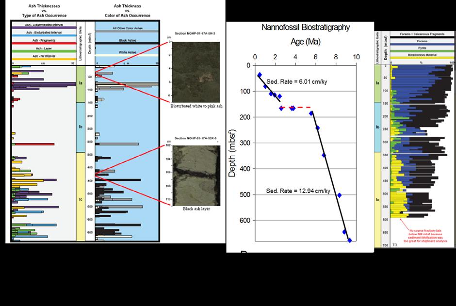
2 Proposed Research In 2006, a gas hydrate dedicated drilling expedition (NGHP-01), led by the National Gas Hydrate Program of India was launched in order to assess the potential reserves of gas hydrate along the Indian continental margins (Fig. 1)[2]. In this proposal, I focus solely on a ~700 meter long (~9.4 Ma) gas hydrate-bearing marine sedimentary record recovered from the Andaman accretionary wedge (NGHP-01 Site 17). Stratigraphic data for the marine sedimentary record recovered at NGHP-01 Site 17 were generated from shipboard[2] and early post-cruise investigations (Fig 2)[3,4]. My proposed research plan capitalizes on this initial research, and provides me with the unique opportunity to pursue research directions focused on the long timescale oceanographic and geologic evolution of this gas hydrate-bearing region. In this project I address three research questions: (1) What is the timing and origin of an observed change from biosiliceous-dominated to carbonate-dominated plankton at Site 17? What is the relationship of this change to similar changes observed in the Atlantic and Pacific oceans during this time? (2) Does an observed depositional hiatus at Site 17 represent a single, long duration event, or does it consist of numerous shorter duration periods of non-deposition? (3) What is the origin of observed compositional variability in the ashes preserved at Site 17? Does this variability imply major changes in the Andaman-Sunda arc through time and/or volcanic inputs to the Site 17 region? To address these research questions I will integrate existing ocean drilling data sets from Site 17 with new X-ray diffraction measurements and trace and rare earth element measurements. Pursuing these new research directions will allow me to reconstruct the ~9.4 Ma depositional history preserved at Site 17 from a geologic, oceanographic, and volcanic perspective.
3 Geologic and Oceanographic Setting NGHP-01 Site 17 is located in a relatively undeformed portion of the Andaman accretionary wedge, just east of Little Andaman Island (Fig. 1). The uplifted seafloor and volcanoes in the Site 17 region formed as a result of the subduction of the India plate beneath the Sunda plate in the Sumatra-Andaman region since the Cretaceous (~130 Ma)[5]. Along the subduction zone margin, volcanic activity is currently active in the south on and near Sumatra and, to a lesser degree, in the Andaman region (Fig. 1)[6]. Volcanic activity has been present in the Sumatra region since the Cretaceous[5], whereas volcanism in the Andaman region and farther north is much younger, and began in the late Pliocene (<3.4 Ma)[7]. The proximal location of Site 17 to several volcanic centers has resulted in the preservation of numerous volcanic ashes (Fig. 2). Initial major element analysis of 4 ash layers reveal mineralogically distinct ashes at the base of the core (basalt) and felsic ashes at the top (rhyolite)[8]. Based on Hf and Nd isotopic signatures of regional volcanoes and 12 ashes from Site 17[8], I hypothesize that the downcore variability of these ashes records the evolution of a small arc segment. To better document this change and test my hypothesis I plan to determine the trace and rare earth elements for 35 discrete ash layers. Past reconstructions of ocean circulation in the Bay of Bengal-Andaman Sea sector suggest that the expansion of Antarctic ice during late Pliocene and early Pleistocene glacials at ~3.5 Ma, Ma, ~2.15 Ma, and Ma[9] are believed to have led to a strengthening of the northward-flowing Circumpolar Deep Water (CPDW) and Antarctic Bottom Water (AABW), and a concomitant weakening of the North Atlantic Deep Water (NADW). Suppression of the NADW most likely resulted in a weakening of southwest monsoon-driven upwelling in the northern Indian Ocean since the mid-pleistocene transition[10]. Changes in upwelling in pre- Pleistocene time, however, are more difficult to establish. Shipboard smear slide and coarse fraction analyses of the sediments at Site 17 indicate that a shift in the marine planktonic organisms has occurred during the past ~9.4 Ma[2]. Specifically, biosiliceous and carbonate marine organisms dominate the lower half of the core, whereas only carbonate-bearing marine organisms dominate the upper half of the core (Fig 2). Detailed examination of this transition at Site 17 and its timing relative to other documented
4 paleoceanographic changes in the region and in the global oceans will allow me to interpret the most likely origin for this major change in community structure. My research will investigate the timing and cause of this transformation and enable me to correlate this record in the Andaman Sea region to similar changes that have been documented in the Pacific Ocean and elsewhere around the world. The nannofossil biostratigraphy at Site 17 reveals two distinct time intervals with different sedimentation rates separated by an apparent depositional hiatus lasting ~1.2 Ma (Fig 2)[11]. This hiatus occurs around the middle Pliocene (~3.8 Ma-2.6 Ma) and suggests that a fundament change in sedimentation rate was either produced through erosion or prolonged near-zero sediment accumulation. The seismic profile across the core location, however, documents a relatively flat-lying stratigraphy with no obvious unconformities, suggesting the missing time was produced through a major decrease in sedimentation. The distinct shift in sedimentation rate and the occurrence of a possible depositional hiatus within the sedimentary record at Site 17 has important implications concerning the depositional history at this site, and higher resolution studies across this interval will elucidate the exact nature of this zone. Research Approaches 1. Investigating the Biogenic Silica to Carbonate Transition I will quantitatively measure the biogenic silica (BSi) content at Site 17 in order to constrain the timing of the biogenic silica to carbonate transition. To measure BSi, I will use standard X-ray diffraction (XRD) techniques on a Siemens D 5000 X-ray Diffractometer located at the University of New Hampshire. Sample material for XRD measurements is available at a sampling frequency of 1sample/1.5m core section throughout the record from residual core sample material that is now housed at UNH. 2. Characterizing the Depositional Hiatus The depositional hiatus in the sedimentary record at Site 17 will be further characterized through more detailed measurements of bulk mineralogy using the XRD. Bulk mineralogical XRD measurements at a sampling frequency of 1sample/1.5m core section will be measured across this transition zone in order to identify any unique changes in sediment composition that
5 might have accompanied or been concentrated during the hiatus. These efforts will provide detailed information regarding whether or not the hiatus is a single, prolonged event, or if it represents a series of events of shorter duration. 3. Determining Ash Geochemistry The volcanic ashes at Site 17 will be characterized with respect to trace and rare earth element abundances. Trace and rare earth elemental compositions will be measured on 35 ash samples that were recovered from Site 17 and are now at UNH. Elemental abundances will be measured at the University of New Hampshire using the Nu AttoM high resolution single collector inductively coupled plasma mass spectrometer (LA-HR-ICP-MS). Results from this effort will serve to establish the compositional changes in the ashes though time and have implications for understanding the evolution of the arc. References [1] Kastner, M., 2001, Gas hydrates in convergent margins: Formation, occurrence, geochemistry and global significance, in Paull, C.K., and Dillon, W.P., eds., Natural gas hydrates: Occurrence, distribution, and detection: American Geophysical Union, p [2] Collett, T.S., Riedel, M., Cochran, J., Boswell, R., Presley, J., Kumar, P., Sathe, A., Sethi, A., Lall, M., Sibal, V., and the NGHP Expedition-01 Scientists, 2008, National Gas Hydrate Program Expedition 01 Initial Reports. [3] Johnson, J.E., Phillips, S.C., Miranda, E., Giosan, L., and Rose, K., 2009, Long-term variability of carbon and nitrogen in the Bay of Bengal and Arabian Sea: Results from NGHP Expedition 1: Eos Transactions, American Geophysical Union, v. 90, Fall Meeting Supplement, Abstract OS44A-01. [4] Guo, J., Underwood, M., Hahn, J., Johnson, J., and Giosan, L., in prep. 2010, Composition of hemipelagic muds from NGHP-01 cores in the Krishna-Godavari Basin, Arabian Sea, and Andaman Sea: NGHP-01 Scientific Results Volume. [5] Shapiro, M.N., 1981, The Sunda-Burma arc and the suggested movement of the Indo- Australian and Eurasian lithospheric plates: Geotectonics, v. 15, p
6 [6] Posavec, M., Taylor, D., Van Leeuwen, T., and Spector, A., 1973, Tectonic controls of volcanism and complex movements along the Sumatran fault system: Geological Society of Malaysia, Bulletin 6, p [7] Pal, T., Chakraborty, P., Gupta, T., and Singh, C., 2003, Geodynamic evolution of the outerarc forearc belt in the Andaman Islands, the central part of the Burma-Java subduction complex: Geology Magazine, v. 140, p [8] Cawthern, T.R., Johnson, J.E., Bryce, J.G., Blichert-Toft, J., and Flores, J.A., 2010, A ~9.4 Ma ash record from the Andaman accretionary wedge: Petrochemical implications for arc evolution, EOS Trans. AGU 91, Fall Meet. Suppl., Abstract V14A-04. [9] Hodell, D.A., and Venz, K., 1992, Toward a high-resolution stable isotopic record of the southern ocean during the Pliocene-Pleistocene (4.8 to 0.8 Ma), in Kennett, J.P., and Warnke, D.A., eds., The Antarctic Paleoenvironment: A Perspective on Global Change (Part 1): American Geophysical Union Antarctic Research Series, v. 56, p [10] Gupta, A.K., and Thomas, E., 2003, Initiation of Northern Hemisphere glaciation and strengthening of the northeast Indian monsoon: Ocean Drilling Program Site 758, Eastern equatorial Indian Ocean: Geology, v. 31, p [11] Flores, J-A, Molina, A., Alvarez, C., Sierro, F., Giosan, L., Johnson, J., and the NGHP Expedition-01 Scientific Party, 2008, Calcareous nannofossil biostratigraphy from sediment cores recovered in the Arabian Sea, Bay of Bengal, and Andaman Sea during NGHP Expedition 01, International Conference on Gas Hydrates, Abstracts with Programs, p


7
Practice Questions: Plate Tectonics
 Practice Questions: Plate Tectonics 1. Base your answer to the following question on The block diagram below shows the boundary between two tectonic plates. Which type of plate boundary is shown? A) divergent
Lecture Outlines PowerPoint. Chapter 13 Earth Science 11e Tarbuck/Lutgens
 Lecture Outlines PowerPoint Chapter 13 Earth Science 11e Tarbuck/Lutgens 2006 Pearson Prentice Hall This work is protected by United States copyright laws and is provided solely for the use of instructors
Chapter 02 The Sea Floor
 Chapter 02 The Sea Floor Multiple Choice Questions 1. One of the following is not one of the world's major ocean basins: A. Atlantic Ocean B. Arctic Ocean C. Indian Ocean D. Antarctic Ocean E. Pacific
Chapter 3. Geology & Tectonics
 Chapter 3 Geology & Tectonics 3.1 Geology The general geological features of Indonesia are shown in Figure 3.1. The basement formation is metamorphic and it is intruded with plutonic formations. They are
USU 1360 TECTONICS / PROCESSES
 USU 1360 TECTONICS / PROCESSES Observe the world map and each enlargement Pacific Northwest Tibet South America Japan 03.00.a1 South Atlantic Arabian Peninsula Observe features near the Pacific Northwest
The Ocean Floor Earth Science, 13e Chapter 13
 The Ocean Floor Earth Science, 13e Chapter 13 Stanley C. Hatfield Southwestern Illinois College The vast world ocean Earth is often referred to as the blue planet Seventy-one percent of Earth s surface
A) B) C) D) 4. Which diagram below best represents the pattern of magnetic orientation in the seafloor on the west (left) side of the ocean ridge?
 B) C) D) 4. Which diagram below best represents the pattern of magnetic orientation in the seafloor on the west (left) side of the ocean ridge?") 1. Crustal formation, which may cause the widening of an ocean, is most likely occurring at the boundary between the A) African Plate and the Eurasian Plate B) Pacific Plate and the Philippine Plate C)
1. Crustal formation, which may cause the widening of an ocean, is most likely occurring at the boundary between the A) African Plate and the Eurasian Plate B) Pacific Plate and the Philippine Plate C)
12. The diagram below shows the collision of an oceanic plate and a continental plate.
 Review 1. Base your answer to the following question on the cross section below, which shows the boundary between two lithospheric plates. Point X is a location in the continental lithosphere. The depth
Lecture 18 Paleoceanography 2
 Lecture 18 Paleoceanography 2 May 26, 2010 Trend and Events Climatic evolution in Tertiary Overall drop of sea level General cooling (Figure 9-11) High latitude (deep-water) feature Two major step Middle
Before Plate Tectonics: Theory of Continental Drift
 Before Plate Tectonics: Theory of Continental Drift Predecessor to modern plate tectonics Shape and fit of the continents was the initial evidence Snider-Pelligrini (1858) Taylor (1908) Wegner (1915) Fig.
The Lithosphere and the Tectonic System. The Structure of the Earth. Temperature 3000º ºC. Mantle
 The Lithosphere and the Tectonic System Objectives: Understand the structure of the planet Earth Review the geologic timescale as a point of reference for the history of the Earth Examine the major relief
Foundations of Earth Science, 6e Lutgens, Tarbuck, & Tasa
 Foundations of Earth Science, 6e Lutgens, Tarbuck, & Tasa Oceans: The Last Frontier Foundations, 6e - Chapter 9 Stan Hatfield Southwestern Illinois College The vast world ocean Earth is often referred
Crustal Boundaries. As they move across the asthenosphere and form plate boundaries they interact in various ways. Convergent Transform Divergent
 Name: Date: Period: Plate Tectonics The Physical Setting: Earth Science CLASS NOTES Tectonic plates are constantly moving and interacting As they move across the asthenosphere and form plate boundaries
Mountain Building. Mountain Building
 Mountain Building Mountain building has occurred during the recent geologic past American Cordillera the western margin of the Americas from Cape Horn to Alaska Includes the Andes and Rocky Mountains Alpine
Marine Science and Oceanography
 Marine Science and Oceanography Marine geology- study of the ocean floor Physical oceanography- study of waves, currents, and tides Marine biology study of nature and distribution of marine organisms Chemical
3. The diagram below shows how scientists think some of Earth's continents were joined together in the geologic past.
 1. The map below shows the present-day locations of South America and Africa. Remains of Mesosaurus, an extinct freshwater reptile, have been found in similarly aged bedrock formed from lake sediments
The Ocean Floor Chapter 14. Essentials of Geology, 8e. Stan Hatfield and Ken Pinzke Southwestern Illinois College
 The Ocean Floor Chapter 14 Essentials of Geology, 8e Stan Hatfield and Ken Pinzke Southwestern Illinois College The vast world ocean Earth is often referred to as the water planet 71% of Earth s surface
Plate Tectonics Tutoiral. Questions. Teacher: Mrs. Zimmerman. Plate Tectonics and Mountains Practice Test
 Teacher: Mrs. Zimmerman Print Close Plate Tectonics and Mountains Practice Test Plate Tectonics Tutoiral URL: http://www.hartrao.ac.za/geodesy/tectonics.html Questions 1. Fossils of organisms that lived
Dynamic Earth Quiz. 4. The accompanying diagram shows some features of Earth s crust and upper mantle.
 DO NOT WRITE ON THIS Dynamic Earth Quiz DO NOT WRITE ON THIS 1. Base your answer(s) to the following question(s) on the diagram below. The diagram shows a model of the relationship between Earth s surface
Crustal Activity. Plate Tectonics - Plates - Lithosphere - Asthenosphere - Earth s surface consists of a major plates and some minor ones
 Name: Date: Period: Tectonics The Physical Setting: Earth Science CLASS NOTES Tectonics - s - Lithosphere - Asthenosphere - Earth s surface consists of a major plates and some minor ones The plates are
GENERAL GEOLOGY Fall Chapter 18: The Sea Floor. Partial Examination IV Study Guide Dr. Glen S. Mattioli
 GENERAL GEOLOGY 1113-005 Fall 2008 Partial Examination IV Study Guide Dr. Glen S. Mattioli Note that these are NOT questions, but rather are a list of topics that we have covered either in class or are
Plate Tectonics: A Unifying Theory
 Plate Tectonics: A Unifying Theory What is Plate Tectonics? - 7 large tectonic plates and many smaller ones that break up the lithosphere - Plates are brittle and float on asthenosphere and glide past
Seismic stratigraphy, some examples from Indian Ocean, interpretation of reflection data in interactive mode
 Seismic stratigraphy, some examples from Indian Ocean, interpretation of reflection data in interactive mode K. S. Krishna National Institute of Oceanography, Dona Paula, Goa-403 004. krishna@nio.org Seismic
INDIAN CONTINENTAL MARGIN GAS HYDRATE PROSPECTS: RESULTS OF THE INDIAN NATIONAL GAS HYDRATE PROGRAM (NGHP) EXPEDITION 01
 EXPEDITION 01") Proceedings of the 6th International Conference on Gas Hydrates (ICGH 2008), Vancouver, British Columbia, CANADA, July 6-10, 2008. INDIAN CONTINENTAL MARGIN GAS HYDRATE PROSPECTS: RESULTS OF THE INDIAN
Proceedings of the 6th International Conference on Gas Hydrates (ICGH 2008), Vancouver, British Columbia, CANADA, July 6-10, 2008. INDIAN CONTINENTAL MARGIN GAS HYDRATE PROSPECTS: RESULTS OF THE INDIAN
Plate Tectonics 22/12/2017
 Map of the tectonic plates. Plate Tectonics In 1912 the meteorologist Alfred Wegener independently developed what he called continental drift, (expanded in his 1915 book The Origin of Continents and Oceans).
Earth s Continents and Seafloors. GEOL100 Physical Geology Ray Rector - Instructor
 Earth s Continents and Seafloors GEOL100 Physical Geology Ray Rector - Instructor OCEAN BASINS and CONTINENTAL PLATFORMS Key Concepts I. Earth s rocky surface covered by of two types of crust Dense, thin,
Plate Tectonics. entirely rock both and rock
 Plate Tectonics I. Tectonics A. Tectonic Forces are forces generated from within Earth causing rock to become. B. 1. The study of the origin and arrangement of Earth surface including mountain belts, continents,
1. Name at least one place that the mid-atlantic Ridge is exposed above sea level.
 Interpreting Tectonic and Bathymetric Maps. The purpose of this lab is to provide experience interpreting the bathymetry of the seafloor in terms of tectonic and geologic settings and processes. Use the
12/3/2014. Plate Tectonics: A Scientific Revolution Unfolds Earth Science, 13e Chapter 7. Continental drift: an idea before its time
 Plate Tectonics: A Scientific Revolution Unfolds Earth Science, 13e Chapter 7 Stanley C. Hatfield Southwestern Illinois College Continental drift: an idea before its time Alfred Wegener First proposed
PHYSICAL GEOLOGY AND THE ENVIRONMENT (2 ND CANADIAN EDITION)
") Chapter 2: Plate Tectonics Chapter Summary: Plate tectonics is a theory that suggests Earth's surface is divided into several large plates that change position and size. Intense geologic activity occurs
Chapter 2: Plate Tectonics Chapter Summary: Plate tectonics is a theory that suggests Earth's surface is divided into several large plates that change position and size. Intense geologic activity occurs
The Sea Floor. Chapter 2
 The Sea Floor Chapter 2 Geography of the Ocean Basins World ocean is the predominant feature on the Earth in total area Northern Hemisphere = 61% of the total area is ocean. Southern Hemisphere = about
Introduction To Plate Tectonics Evolution. (Continents, Ocean Basins, Mountains and Continental Margins)
") Introduction To Plate Tectonics Evolution (Continents, Ocean Basins, Mountains and Continental Margins) Geo 386 (Arabian Shield Course) Dr. Bassam A. A. Abuamarah Mohanna G E O 3 8 6 A R A B I A N G E
Introduction To Plate Tectonics Evolution (Continents, Ocean Basins, Mountains and Continental Margins) Geo 386 (Arabian Shield Course) Dr. Bassam A. A. Abuamarah Mohanna G E O 3 8 6 A R A B I A N G E
Joides Resolution at Hong-Kong
 Report from Iván Hernández-Almeida, post-doc at the Oeschger Centre for Climate Change Research/Institute of Geography, University of Bern. Shipboard Micropaleontologist (radiolarian specialist) on IODP
Gas hydrate on the continental margin. Hitoshi Tomaru
 Gas hydrate on the continental margin Hitoshi Tomaru Department of Earth and Planetary Science, University of Tokyo 7-3-1 Hongo, Bunkyo-ku, Tokyo 113-0033, Japan E-mail: tomaru@eps.s.u-tokyo.ac.jp Tel:
Questions and Topics
 Plate Tectonics and Continental Drift Questions and Topics 1. What are the theories of Plate Tectonics and Continental Drift? 2. What is the evidence that Continents move? 3. What are the forces that
Global Tectonics. Kearey, Philip. Table of Contents ISBN-13: Historical perspective. 2. The interior of the Earth.
 Global Tectonics Kearey, Philip ISBN-13: 9781405107778 Table of Contents Preface. Acknowledgments. 1. Historical perspective. 1.1 Continental drift. 1.2 Sea floor spreading and the birth of plate tectonics.
Late 20 th Century Tests of the Continental Drift Hypothesis
 Late 20 th Century Tests of the Continental Drift Hypothesis 5 Characteristics of the Ocean Trenches Unless otherwise noted the artwork and photographs in this slide show are original and by Burt Carter.
READING QUESTIONS: Chapter 11, Plate Tectonics GEOL 131 Fall pts
 READING QUESTIONS: Chapter 11, Plate Tectonics GEOL 131 Fall 2018 61 pts NAME DUE: Tuesday, November 20 Continental Drift: An Idea Before Its Time (p. 317-321) 1. Fill in the blanks in this sentence from
PLATE TECTONICS. Continental Drift. Continental Drift. Continental Drift. Continental Drift- Wegener s Evidence
 Continental Drift PLATE TECTONICS E.B. Taylor (1910) and Alfred Wegener (1915) published on Continental Drift. Continental Drift Wegener s evidence 1. Fit of the Continents 2. Fossil Evidence 3. Rock Type
A Transformation from Acoustic and Density Properties to Reservoir Properties applied to Krishna Godavari Basin, India
 P-439 Summary A Transformation from Acoustic and Density Properties to Reservoir Properties applied to Krishna Godavari Basin, India Debjani Bhowmick*and Deepak K. Gupta, Indian School of Mines Uma Shankar
Evolution of Continents Chapter 20
 Evolution of Continents Chapter 20 Does not contain complete lecture notes. Mountain belts Orogenesis the processes that collectively produce a mountain belt Includes folding, thrust faulting, metamorphism,
Earth / Environmental Science. Ch. 14 THE OCEAN FLOOR
 Earth / Environmental Science Ch. 14 THE OCEAN FLOOR The Blue Planet Nearly 70% of the Earth s surface is covered by the global ocean It was not until the 1800s that the ocean became an important focus
8. Climate changes Short-term regional variations
 8. Climate changes 8.1. Short-term regional variations By short-term climate changes, we refer here to changes occurring over years to decades. Over this timescale, climate is influenced by interactions
Chapter 9 Lecture Outline. Oceans: The Last Frontier
 Chapter 9 Lecture Outline Oceans: The Last Frontier The Vast World Ocean Earth is referred to as the blue planet 71% of Earth s surface is oceans and marginal seas Continents and islands comprise the remaining
Section 2: How Mountains Form
 Section 2: How Mountains Form Preview Objectives Mountain Ranges and Systems Plate Tectonics and Mountains Types of Mountains Objectives Identify the types of plate collisions that form mountains. Identify
Biogeochemistry of trace elements and isotopes in the Indian Ocean
 Biogeochemistry of trace elements and isotopes in the Indian Ocean Sunil Kumar Singh Geosciences Division Physical Research Laboratory Ahmedabad 380009 Ministry of Earth Sciences Government of India 2
Plate Tectonics 3. Where Does All the Extra Crust Go?
 Plate Tectonics 3 Where Does All the Extra Crust Go? Unless otherwise noted the artwork and photographs in this slide show are original and by Burt Carter. Permission is granted to use them for non-commercial,
Plate Tectonics Lab II: Background Information
 Plate Tectonics Lab II: Background Information This lab is based on a UW ESS101 Lab. Note: Hand in only the Answer Sheet at the back of this guide to your Instructor Introduction One of the more fundamental
Review participation point: The evidence for a fluid outer core is:
 DDA1 Continental Drift to Plate Tectonics PS 100 Chapter 28 Review participation point: The evidence for a fluid outer core is: A. Average density of the earth is greater than the density of the crust.
CHAPTER 2 THE WAY THE EARTH WORKS: EXAMINING PLATE TECTONICS
 CHAPTER 2 THE WAY THE EARTH WORKS: EXAMINING PLATE TECTONICS Coverage of plate tectonics is required early in introductory Geology as context for the mineralogy, petrology, structure, internal processes,
Empirical trends of velocity- porosity and velocity-density in shallow sediment in Kerala- Konkan Basin on the west coast of India
 P-444 Summary Empirical trends of velocity- porosity and velocity-density in shallow sediment in Kerala- Konkan Basin on the west coast of India Maheswar Ojha*, Kalachand Sain, NGRI During the expedition
caribbean basins, tectonics and hydrocarbons university of texas institute for geophysics
 Copyright by Trevor John Aitken 2005 CENOZOIC STRATIGRAPHIC AND TECTONIC HISTORY OF THE GRENADA AND TOBAGO BASINS AS DETERMINED FROM MARINE SEISMIC DATA, WELLS, AND ONLAND GEOLOGY by Trevor John Aitken,
Lecture #13 notes, Geology 3950 Spring 2006: CR Stern Magnetic reversals (text pages th edition and in the 5 th edition)
") Lecture #13 notes, Geology 3950 Spring 2006: CR Stern Magnetic reversals (text pages 35-37 4 th edition and 53-55 in the 5 th edition) The earth has a magnetic field generated by circulation of charged
Lecture #13 notes, Geology 3950 Spring 2006: CR Stern Magnetic reversals (text pages 35-37 4 th edition and 53-55 in the 5 th edition) The earth has a magnetic field generated by circulation of charged
Ocean Basins, Bathymetry and Sea Levels
 Ocean Basins, Bathymetry and Sea Levels Chapter 4 Please read chapter 5: sediments for next class and start chapter 6 on seawater for Thursday Basic concepts in Chapter 4 Bathymetry the measurement of
Directed Reading. Section: How Mountains Form MOUNTAIN RANGES AND SYSTEMS. Skills Worksheet
 Skills Worksheet Directed Reading Section: How Mountains Form 1. How high is Mount Everest? a. about 1980 km above sea level b. more than 8 km below sea level c. more than 8 km above sea level d. more
Section 7. Reading the Geologic History of Your Community. What Do You See? Think About It. Investigate. Learning Outcomes
 Chapter 3 Minerals, Rocks, and Structures Section 7 Reading the Geologic History of Your Community What Do You See? Learning Outcomes In this section, you will Goals Text Learning Outcomes In this section,
ARE YOU READY TO THINK? Look at the first slide THINK PAIR SHARE!
 ARE YOU READY TO THINK? Look at the first slide THINK PAIR SHARE! WHAT PROMINENT FEATURE CAN YOU IDENTIFY IN THIS PICTURE? What do you think the different colors represent? Who might find such a picture
Chapter Two. Figure 02_02. Geography of the Ocean Basins. The Sea Floor
 Chapter Two The Sea Floor Geography of the Ocean Basins Figure 02_02 The world ocean is the predominant feature on the Earth in total area. In the Northern Hemisphere, 61% of the total area is ocean. In
BALOCHISTAN FOLDBELT BASIN
 INTRODUCTION BALOCHISTAN FOLDBELT BASIN The Kharan-3 block is located in the Kharan Trough of Balochistan Basin. GEOLOGICAL SETTING The Balochistan Province is an Upper Cretaceous to Recent structurally
Question: What is the primary reason for the great abundance of fish along the Peruvian coast?
 Buzzer Question # 1 Question Type: toss-up Question Format: Multiple Choice Category: Biology What is the primary reason for the great abundance of fish along the Peruvian coast? Answer W: upwelling Answer
Laboratory #7: Plate Tectonics
 Materials Needed: 1. Pencil 2. Colored Pencils 3. Metric/Standard Ruler 4. Calculator 5. Tracing Paper Laboratory #7: Plate Tectonics Plate Tectonics The Earth is composed of layers. At the center is a
Physical Geology, 15/e
 Lecture Outlines Physical Geology, 15/e Plummer, Carlson & Hammersley Plate Tectonics: The Unifying Theory Physical Geology 15/e, Chapter 19 Plate Tectonics Plate Tectonics Earth s surface is composed
Small area of the ocean that is partially surrounded by land. The Ocean Basins. Three Major Oceans. Three Major Oceans. What is a SEA?
 The Ocean Basins How Deep is the Ocean? 1 2 Three Major Oceans Three Major Oceans Pacific Atlantic the shallowest ocean (3.3km average depth) Indian second shallowest ocean (3.8km average depth) Pacific
Plate Tectonics. I. The Discovery of Plate Tectonics II. A Mosaic of Plates III. Types of Plate Boundaries IV. How Plates Move
 Plate Tectonics I. The Discovery of Plate Tectonics II. A Mosaic of Plates III. Types of Plate Boundaries IV. How Plates Move I. The Discovery of Plate Tectonics A. Continental Drift (Alfred Wegener) Proposed
Dynamic Earth A B1. Which type of plate boundary is located at the Jordan Fault? (1) divergent (3) convergent (2) subduction (4) transform
 divergent (3) convergent (2) subduction (4) transform") Dynamic Earth A B1 1. The edges of most lithospheric plates are characterized by (1) reversed magnetic orientation (2) unusually rapid radioactive decay (3) frequent volcanic activity (4) low P-wave and
Dynamic Earth A B1 1. The edges of most lithospheric plates are characterized by (1) reversed magnetic orientation (2) unusually rapid radioactive decay (3) frequent volcanic activity (4) low P-wave and
General Oceanography Geology 105 Expedition 8 Plate Boundaries Beneath the Sea Complete by Thursday at 11:00 PM
 General Oceanography Geology 105 Expedition 8 Plate Boundaries Beneath the Sea Complete by Thursday at 11:00 PM Name Expedition Objectives Learn about the types of plate boundaries and their key characteristics
Earth s Tectonic Plates
 MASTER 49 6.2 3.7 5.4 Philippine Pacific 5.4 North American Juan de Fuca Caribbean Cocos 10.0 9.2 2.3 2.5 2.3 1.8 3.0 Indian-Australian 10.5 7.1 17.2 16.8 6.0 Nazca South American 11.1 10.3 7.3 3.7 7.5
IODP drilling and core storage facilities
 4 IODP drilling and core storage facilities Neville Exon As the knowledge obtainable from ocean drilling is various and extensive, its end-users are similarly various and extensive. Scientific ocean drilling
The continental lithosphere
 Simplicity to complexity: The continental lithosphere Reading: Fowler p350-377 Sampling techniques Seismic refraction Bulk crustal properties, thickness velocity profiles Seismic reflection To image specific
Earth Movement and Resultant Landforms
 Earth Movement and Resultant Landforms Structure of the Earth Lithosphere : earth s crust Asthenosphere : upper mantle zone where material is near its melting point & acts almost like liquid (appprox.
1. I can describe evidence for continental drift theory (e.g., fossil evidence, mountain belts, paleoglaciation)
") Science 10 Review Earth Science Vocabulary asthenosphere continental drift theory converging plates diverging plates earthquakes epicentre fault hot spot inner core lithosphere mantle mantle convection
Science 10 Review Earth Science Vocabulary asthenosphere continental drift theory converging plates diverging plates earthquakes epicentre fault hot spot inner core lithosphere mantle mantle convection
60% water. Big Bang: 14,000 millions years ago The Earth originated about 4,500 millions years ago its orbit allows water to exist in a liquid state!
 Ch2. The Sea Floor #1 Why geology of the oceans? Marine habitats are directly shaped by geological processes The form of the coastlines The depth of the water Type of bottom (muddy, sandy, rocky) #2 Geological
OCN 201 Physiography of the Seafloor
 OCN 201 Physiography of the Seafloor Hypsometric Curve for Earth s solid surface Note histogram Hypsometric curve of Earth shows two modes. Hypsometric curve of Venus shows only one! Why? Ocean Depth vs.
OCN 201 Physiography of the Seafloor
 OCN 201 Physiography of the Seafloor 1 Ocean Depth versus Continental Height Why do we have dry land? Solid surface of Earth is dominated by two levels: Land with a mean elevation of +840 m (29% of Earth
Geology Topics. Unit 6 Notes
 Geology Topics Unit 6 Notes Composition of the Earth Earth is layered due to density differences. Crust thin outer layer, solid, made up of continental and oceanic crust Mantle rocky layer below the crust
Continental Drift and Plate Tectonics
 Continental Drift and Plate Tectonics Continental Drift Wegener s continental drift hypothesis stated that the continents had once been joined to form a single supercontinent. Wegener proposed that the
1. Define habitat and describe how geologic processes influence habitats. Habitats 2. How much of the earth s surface is covered by sea water?
 1. Define habitat and describe how geologic processes influence habitats. Habitats are the natural environments in which organisms live. They are directly shaped by geological processes, which influence
Geology 15 West Valley College. Exam IV: Sierra Nevada
 Geology 15 West Valley College Name Exam IV: Sierra Nevada 1) On the diagram above, where is the Arc- Trench Gap? a. 1 and 3 c. 7 and 8 d. 6 e. 5 and 10 2) On the diagram above, where is the subduction
Overview of Indonesian Geothermal System
 Overview of Indonesian Geothermal System The Resources Beyond High Enthalpy Magmatic/Volcanic Systems By Dr.Eng. Suryantini ITB 4/3/2017 1 Outline Current Condition of Indonesian Geothermal Resources and
Plate Tectonics: A Scientific Revolution Unfolds
 Chapter 2 Lecture Earth: An Introduction to Physical Geology Eleventh Edition Plate Tectonics: A Scientific Revolution Unfolds Tarbuck and Lutgens From Continental Drift to Plate Tectonics Prior to the
Supplementary Material for Eighty million years of folding migration: new perspective on the Syrian Arc from Levant basin analysis
 GSA Data Repository 2018040 https://doi.org/10.1130/g39654.1 Supplementary Material for Eighty million years of folding migration: new perspective on the Syrian Arc from Levant basin analysis Sagy Yael,
From the mountains to the ocean
 Background From the mountains to the ocean Using Google Earth and Ocean Cores to discover the concept of erosion and sediment transportation In 2004, a magnitude >9 earthquake struck North Sumatra and
News Release December 30, 2004 The Science behind the Aceh Earthquake
 News Release December 30, 2004 The Science behind the Aceh Earthquake PASADENA, Calif. - Kerry Sieh, the Robert P. Sharp Professor of Geology at the California Institute of Technology and a member of Caltech's
General Oceanography Geology 105 Expedition 8 Plate Boundaries Beneath the Sea
 General Oceanography Geology 105 Expedition 8 Plate Boundaries Beneath the Sea Name Not attempting to answer questions on expeditions will result in point deductions on course workbook (two or more blank
MARINE GEOLOGY & GEOGRAPHY
 MARINE GEOLOGY & GEOGRAPHY Bathymetry BATHYMETRY BATHYMETRY THE UNDERWATER EQUIVALENT TO TOPOGRAPHY THE STUDY OF WATER DEPTH A BATHYMETRIC MAP SHOWS FLOOR RELIEF OR TERRAIN AS CONTOUR LINES Bathymetry
Earth s Seafloors. Ocean Basins and Continental Margins. Introductory Oceanography Ray Rector - Instructor
 Earth s Seafloors Ocean Basins and Continental Margins Introductory Oceanography Ray Rector - Instructor OCEAN BASINS and CONTINENTAL PLATFORMS Key Concepts I. Earth s rocky surface covered by of two types
Directed Reading. Section: The Water Planet. surface is called the a. Earth s ocean. b. Pacific Ocean. c. salt-water ocean. d. global ocean.
 Skills Worksheet Directed Reading Section: The Water Planet 1. The body of salt water covering nearly three-quarters of the Earth s surface is called the a. Earth s ocean. b. Pacific Ocean. c. salt-water
The Indian Ocean. Copyright 2010 LessonSnips
 The Indian Ocean One of the five major geographic divisions of the world s ocean, the Indian Ocean is located in the Eastern Hemisphere. The Indian Ocean is bounded by three continents: Africa to the west,
Origin and Evolution of the Ocean Floor
 Origin and Evolution of the Ocean Floor Outline Mapping the Ocean Floor Continental Margins Origin of Oceanic Lithosphere Structure of Ocean Crust Mapping the ocean floor Depth originally measured by lowering
Evaluator: Eric Pyle James Madison University
 Building Core Knowledge Reconstructing Earth History Transforming Undergraduate Instruction by Bringing Ocean Drilling Science on Earth History and Global Climate Change into the Classroom This NSF-funded,
14.2 Ocean Floor Features Mapping the Ocean Floor
 14.2 Ocean Floor Features Mapping the Ocean Floor The ocean floor regions are the continental margins, the ocean basin floor, and the mid-ocean ridge. 14.2 Ocean Floor Features Continental Margins A continental
Chapter 15 Millennial Oscillations in Climate
 Chapter 15 Millennial Oscillations in Climate This chapter includes millennial oscillations during glaciations, millennial oscillations during the last 8000 years, causes of millennial-scale oscillations,
6. In the diagram below, letters A and B represent locations near the edge of a continent.
 1. Base your answer to the following question on the cross section below and on your knowledge of Earth science. The cross section represents the distance and age of ocean-floor bedrock found on both sides
The Dynamic Crust 2) 4) Which diagram represents the most probable result of these forces? 1)
 4) Which diagram represents the most probable result of these forces? 1)") 1. The diagrams below show cross sections of exposed bedrock. Which cross section shows the least evidence of crustal movement? 1) 3) 4. The diagram below represents a section of the Earth's bedrock. The
1. The diagrams below show cross sections of exposed bedrock. Which cross section shows the least evidence of crustal movement? 1) 3) 4. The diagram below represents a section of the Earth's bedrock. The
Copyright McGraw-Hill Education. All rights reserved. No reproduction or distribution without the prior written consent of McGraw-Hill Education
 Copyright McGraw-Hill Education. All rights reserved. No reproduction or distribution without the prior written consent of McGraw-Hill Education Tibetan Plateau and Himalaya -southern Asia 11.00.a VE 10X
Chapter 10: Deformation and Mountain Building. Fig. 10.1
 Chapter 10: Deformation and Mountain Building Fig. 10.1 OBJECTIVES Describe the processes of rock deformation and compare and contrast ductile and brittle behavior in rocks. Explain how strike and dip
*To whom correspondence should be addressed: FAX: (886) ;
 ;") DATA REPORT: CARBONATE AND ORGANIC CARBON CONTENTS OF SEDIMENTS FROM SITES 1143 AND 1146 IN THE SOUTH CHINA SEA Li-Wen Wang* and Hui-Ling Lin Institute of Marine Geology and Chemistry National Sun Yat-Sen
DATA REPORT: CARBONATE AND ORGANIC CARBON CONTENTS OF SEDIMENTS FROM SITES 1143 AND 1146 IN THE SOUTH CHINA SEA Li-Wen Wang* and Hui-Ling Lin Institute of Marine Geology and Chemistry National Sun Yat-Sen
Earth overall average density = 5.5 g/cm 3 Temp increases with depth, the thermal gradient 30 0 C/km Pressure and the density also increase with
 Plate Tectonics Earth Earth overall average density = 5.5 g/cm 3 Temp increases with depth, the thermal gradient 30 0 C/km Pressure and the density also increase with depth Spheroid: with a longer major
North America subducted under Rubia. Are there modern analogs for Hildebrand s model of North America subducting under Rubia?
 North America subducted under Rubia Are there modern analogs for Hildebrand s model of North America subducting under Rubia? In the Geological Society of America Special Papers Did Westward Subduction
is a unifying theme in modern geology that integrates the earlier ideas of
 The concept of Global Plate Tectonics is a unifying theme in modern geology that integrates the earlier ideas of continental drift, sea-floor spread, and mountain building To explain why the present ocean