Oceanography. Chapter 4 THE SEA FLOOR. PDF created with pdffactory Pro trial version
|
|
|
- Holly Powell
- 5 years ago
- Views:
Transcription
1 Oceanography Chapter 4 THE SEA FLOOR أ. راي د مرعي الخالدي
2 The Sea Floor 4.1 The Sea Floor 4.2 The Continental Margin 4.3 The Ocean Basin Floor 4.4 The Ridges and Rises 4.5 The Trenches 4.6 Measuring the Depths 4.7 Sediments Size Location Source and Chemistry 4.8 Sampling the Sediments 4.9 Seabed Resources Mineral Resources Gas Hydrates Mining Laws and Treaties Prepared by: RaedM.Khaldi
3 THE SEA FLOOR Major Concept (I) The early concepts of the ocean basins envisioned them as being static depressions filled with the sediment eroded from the continents. It was generally believed that the sea floor was flat and featureless. - Early geologists believed the sea floor was flat for two reasons: a. the sea floor was not tectonically active so there were no mountains or faults, and b. sediment carried to the oceans would blanket the sea floor and smooth out any irregularities. -With time it became important for shallow coastal waters to be surveyed accurately for navigational purposes. In this way, some of the irregularity of the sea floor was revealed. -Routine mapping of the sea floor did not occur until after WWII when some of the technology developed for the war could be applied to peaceful, scientific purposes. Prepared by: Raed M.Khaldi
4 - From the 1950s on to the present day we have learned about the dynamic nature of the sea floor and the abundance of geologic features in the ocean basins. Major Concept (II) The sea floor has the same major geologic features that we see on land, including mountains, valleys, plateaus, and faults. - Although the sea floor has the same types of structures we see on the continents, they are often of grander proportions than on land because of less severe erosional forces. - Landforms are modified relatively quickly by mechanical means such as wind, running water, rain, and moving ice. In addition, they can be chemically eroded and broken down by repeated changes in temperature either seasonally or daily.
5 - On the sea floor many of the active erosional agents on land are not found. There is no wind, moving ice, or rainfall. Temperatures are essentially constant on the sea floor. - The major erosional agents in the oceans are waves and currents, and even these are able to act quickly only in shallow, near-coastal waters. - Erosion in the oceans is very slow. One of the most important modifying processes is the blanketing of the sea floor with sediment that settles out of the water column.
6 Major Concept (III) The edges of the continents continue seaward to form the.الرصیف القاري continental margin - There are two different kinds of continental margins, passive and active. Passive continental margins are not plate boundaries. Active continental margins are plate boundaries. - Passive continental margins can be subdivided into the following distinct regions:, الرف القاري a. continental shelf b. shelf break, c. continental slope القاري,المیل and. الدرج القاري d. continental rise
7 - Along active continental margins the continental slope commonly descends into a deep ocean trench and there is no continental rise unless large amounts of sediment eroded from the continent have filled the trench. - A profile across a typical passive continental margin is shown in figure 4.2 in your text. - The continental shelf region has the following characteristics: a. consists of continental material, b. relatively flat lying with average gradients of about 2 m/km, c. varies in width from tens of meters to over 100 km with an average width of about 65 km, and d. slopes seaward to a maximum depth at their outer edge that varies from 35 m to 350 m, averaging about 130 m. - With the rising and falling of sea level in response to the ice ages, the continental shelves have been periodically exposed to the air and submerged. When sea level was low they were subject to continental erosional processes as well as the deposition of sediments by rivers and streams.

8

9
10 - Some continental shelves are covered with thick deposits of relict, or old, continental sediments. Other shelves have been stripped of sediments by powerful currents that flow over them now. - The width of the shelf is typically related to the coastal relief of the land. Where there are mountains near the shore the shelf is often narrow, while low-lying lying coastal regions are often adjacent to broad continental shelves. - The continental shelves are thought to be created by a number of different processes including: a. the constant erosion of the coast by wave action, and b. the trapping of sediment behind structural dams created by reefs, volcanic mounds, salt domes, and upthrown blocks of rock. - The outer edge of the shelf is marked by a distinct change in slope of the sea floor called the continental shelf break - Beyond the shelf break the continental margin continues across a region called the continental slope that descends at an average gradient of about 70 m/km. Prepared by: Raed M.Khaldi
11 - The continental slope is usually too steep for significant amounts of sediment to accumulate on it. - The slope will generally extend downward to depths in excess of 3000 m except where there is a deep ocean trench along the continental margin, in which case it may continue to depths of 8000 m or more. - The slopes are periodically cut by massive rifts called submarine canyons بحریة.ودیان. These canyons can extend upward across the shelves. - Submarine canyons are thought to have been cut initially by rivers during low stands of sea level. They are V-shaped V in cross section and may have profiles similar to the Grand Canyon in terms of width and depth (take a look at fig. 4.4). Prepared by: Raed M.Khaldi
12 - Submarine canyons can direct the flow of avalanches of dense sediment-water mixtures called turbidity currents that flow down slope and onto the sea floor to build the continental rise. When these currents exit the bottom of the canyon they spread out and the suspended sediment particles are deposited in order of size with the largest falling out first. This creates deposits called turbidites with graded bedding; largest particles on the bottom and smaller ones on top (see fig. 4.5). - In 1929 a large turbidity current broke a series of trans- Atlantic telephone cables south of New Foundland.. The turbidity current moved at a speed of as much as 80 km (50 mi)/hr down the continental slope and about 24 km (15mi)/hr on the more gently sloping continental rise. It traveled a distance of about 650 km (400 mi). - The continental rise is a wedge of sediment with an intermediate gradient averaging about 9 m/km that is built up by repeated turbidite deposits. - The continental rise is seen frequently in the Atlantic and Indian oceans but not the Pacific because of the presence of numerous deep trenches. Prepared by: Raed M.Khaldi
13 Major concept (IV) The deep ocean floor is a vast region covering about 30 percent of the planet's surface. It extends in depth from about 4000 to 6000 meters (13,000 to 20,000 ft). -The deep sea floor is often relatively smooth near continental margins. This is due to the covering of any irregularities by large amounts of sediment carried to the oceans. This broad, flat part of the deep ocean is called the abyssal.الغاي رات المستویة plain -With increasing distance from the continents the sediment cover can thin and irregularities in the sea floor will be more apparent.

14
15 التلال -Major features of positive relief include abyssal hills and seamounts. Abyssal hills are volcanic features الغاي رات less than 1000 m (3300 ft) high and seamounts are volcanic features taller than 1000 m (see fig. 4.6). Abyssal hills may be the most common geologic feature on earth, covering about 50 percent of the Atlantic and 80 percent of the Pacific sea floors. They are also known to be widespread in the Indian Ocean but have not been surveyed there as extensively. -Other common features in warm water ocean regions are reef structures built by corals. Coral reefs require warm, clear water at shallow depths because they grow in association with a single-celled plant that requires sunlight for photosynthesis. -There are three stages in the life history of a coral reef. These are shown in figure 4.7 as: a. the fringing reef that grows around the edge of an island,
16 b. the barrier reef that forms as the island sinks due to subsidence and creates a lagoon between the reef and the island, and c. the formation of a roughly circular reef called an atoll that surrounds a central lagoon formed when الحلقات المرجانیة the island sinks beneath the surface. - This progressive development was first suggested by Charles Darwin during his voyage on the HMS Beagle from As islands sink they will have their tops eroded nearly flat by wave action. Continued subsidence then produces flattopped seamounts called guyots. Many of them have coral debris on them proving that they were once near the surface. - Guyots are found most frequently in the Pacific Ocean at depths from 1000 to 1700 m (3300 to 5600 ft) beneath the surface. Many guyots are found at a depth of 1300 m (4300 f t) beneath the surface. - Mechanisms responsible for the subsidence of islands are discussed in the next chapter.

17 Diagram of coral atoll formation


18
19 Major Concept (V) The longest continuous mountain system on the planet winds its way through the ocean basins in a series of connected ridges and rises often called the mid-ocean ridge.الظھور الوسط محیطیة system - The mid-ocean ridge system is often described as being like the stitching on a baseball. It extends throughout the oceans for a combined length of about 65,000 km (40,000 mi). This is shown schematically in figure The ridge system is about 1000 km (600 mi) wide and ranges in height above the surrounding abyssal plain 1000 to 2000 m (3500 to 7000 ft). - The cross-sectional profile of the system varies along its length. Where it is steep it is called a ridge and where it is more gentle it is called a rise. Ridges are dominant in the Atlantic and Indian oceans while rises are more frequently found in the Pacific Ocean.
20 - Along the ridges the axis of the ridge is often marked by a deep central rift valley 15 الوادي الغاي ر to 50 km (9 to 30 mi) wide and 500 to 1500 m (1500 to 5000 ft) deep. - The axis of the system is volcanically and seismically active. - On closer inspection the ridge system is not continuous. It is broken into segments that are offset from one another by faults called transform faults. Transform faults are perpendicular to ridge segments and may extend beyond the region between ridge segments as fracture zones. - The oceanic ridge system effectively divided the deep sea floor into a number of semi-isolated basins that can trap and direct the movement of bottom water.

21


22 great rift valley in Africa
23 Major Concept (VI) Massive gashes cut across the sea floor in some areas. These narrow, elongate deeps are called deep-ocean trenches. - Trenches الاغوار السحیقة are most common in the Pacific Ocean, as can be seen in figure 4.9. They rim the Pacific basin and are associated with active volcanic island arcs and active volcanism along continental margins. - The deepest spot in the oceans is found in the Challenger Deep of the Mariana Trench at a depth of 11,020 m. - Trenches vary in length up to a maximum of 5900 km (3700 mi) in the case of the Peru-Chile Trench. - The Atlantic Ocean has only two short trenches and the Indian Ocean has one trench of intermediate length. - Trenches are relatively narrow, approximately 100 to 200 km, and have steep walls. The wall of the trench facing the open ocean is generally less steep than the other one. Prepared by: Raed M.Khaldi

24 Gyotes and trench
25 - A more advanced stage of rifting is represented by the Red Sea, where seawater has inundated the rift and a new ocean basin is forming. - The newly created continental margin that is adjacent to the rift is called a trailing margin. - Trailing margins, also called passive margins, are not tectonically active. They generally are not associated with earthquake or volcanic activity. They are often fairly broad and low lying with thick accumulations of sediment. A good example is the east coast of the United States. - Most divergent boundaries are located along the axis of the mid-ocean ridge system.
26 Major Concept (VII) Ocean depths and seafloor features have been measured in a variety of increasingly accurate and sophisticated ways throughout time. - Ocean depths are usually reported in one of two different units, the meter or the fathom. A fathom is equal to six feet. - The first deep measurements of the seas were made using a lead weight attached to a rope that was marked in fathoms. The end of the weight was often hollowed out and filled with grease so that particles of sediment would be embedded in it when it struck bottom and could later be recovered when the weight was retrieved. This was a reasonably accurate method in shallow water and could even help sailors navigate by knowing what type of bottom material was below.
27 -In deep water this method was not very efficient because of the weight of the line and the time required to lower it. Consequently, a slightly modified technique was employed that used piano wire and a cannonball. The wire was light and the ball was so heavy that it would travel downward more rapidly and was easier to sense when it hit the bottom. - In very deep water, it could still take as long as 8 to 10 hours to take a single sounding, or measurement of depth. By 1895 there were still only about 7000 measurements in water deeper than 2000 m and only 550 in water deeper than 9000 m. This was clearly inadequate to give geologists any understanding of seafloor topography. -The echo sounder, or depth recorder, was invented in the 1920s and tested on board the Meteor expedition in the Atlantic Ocean. An example of an echo sounder record is shown in figure The echo sounder emits a pulse of sound that travels down through the water and reflects from the sea floor to return to the surface. The velocity of propagation of sound in seawater is nearly constant, so by timing how long it takes for the sound to travel the round trip from the ship to the bottom and back, it is easy to compute depth.
28 -The great advantage of the echo sounder is that measurements can be taken continuously and with great accuracy while the ship is under way. -We currently have fairly detailed knowledge of submarine features thanks to precision depth recorders, cameras, deep-towed sonar, and manned submersibles. -Large scale seafloor features can be detected by observing variations in the height of the sea surface due to changes in gravity using satellites (fig. 4.12). -The excess mass of large seamounts and ridges creates a gravitational attraction that draws water toward them, resulting in an elevation of the sea surface. Sea level is elevated by as much as 5 m (16 ft) over large seamounts and 10 m (33 ft) over ocean ridges. -The lack of mass due to deep sea trenches produces a weaker gravitational attraction where water will be drawn away from the region by areas of greater mass elsewhere. This creates a depression of the sea surface of as much as 25 to 30 m ( ft). -These changes in elevation occur over tens to hundreds of kilometers so the slopes involved are very gentle.
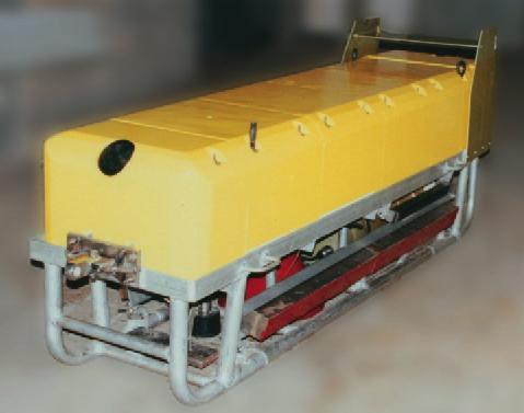

29 baseball deep-towed sonar cannonball
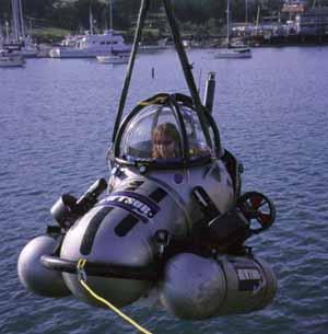

30 manned submersibles

31


32
33 Major Concept (VIII): Sediments can also be classified by size. Size is a very important factor in a number of other respects including the rate at which particles will sink, the probability a particle will be dissolved before it reaches the bottom, the distance it is likely to travel from its source, and the energy level of its area of deposition. - Sediment particles can be classified by diameter as indicated in table There are three major subdivisions of particle size, each of which is further broken down into a number of smaller divisions. From largest to smallest these are: a. gravel, i. boulder ii. cobble iii. Pebble iv. granule Prepared by: Raed M.Khaldi
34
35 b. sand, i. very coarse sand ii. coarse sand iii. medium sand iv. fine sand v. very fine sand c. mud. i. silt ii. clay - Sediments are well sorted if nearly all the particles are of the same size and poorly sorted if sizes vary markedly. In general, well sorted sediments have been subjected to high energy environments where fast moving water has been able to carry away small particles and leave larger ones behind.
36 - Sinking rates are generally related to particle size. Larger particles sink at faster rates. - Sand-sized particles may settle to the deep sea floor in a matter of days while it may take clay-sized particles over 100 years. - The slower the sinking rate the more likely a particle will be transported by currents or dissolved before it reaches the bottom. - Very small particles can sink at faster rates due to two different effects: a. if they are charged particles they can attract each other and clump into larger masses that will sink more rapidly, or b. organisms may ingest large numbers of smaller particles and then expel them in fecal pellets large enough to sink to the bottom in days rather than several decades. It is estimated that as many as 100,000 microscopic shells of tiny organisms can be packaged in a single fecal pellet.
37 Major Concept (IX) Marine sediment can also be classified by where it accumulates (fig. 4.16). - Marine sediment can be classified as either neritic or pelagic. - Neritic sediments are found near continental margins and islands. - Most neritic sediments are eroded from rocks on land and transported to the coast by rivers and streams. - As much as 15 billion metric tons of sediment are carried to the oceans annually. - Accumulation rates are highly variable. In quiet bays they may be as high as 500 cm (200 in)/yr. On continental shelves and slopes they may be 10 to 40 cm (4 to 16 in)/1000 yrs. - Pelagic sediments accumulate on the deep sea floor. They are typically very finegrained.
38 - The thickness of pelagic sediments increases with increasing age of the sea floor, or increasing distance from the ridge. - An average accumulation rate for pelagic sediment is 0.5 to 1.0 cm (0.2 to 0.4 in)/1000 yrs. - The average thickness of pelagic sediment on the deep sea floor is 500 to 600 m (1600 to 2000 ft). It would take about 100 million years for this much pelagic sediment to accumulate. Major Concept (X) Another method of classifying sediment is by grouping it according to the origin and chemistry of the particles that make up the sediment.
39 - There are four major sources of sediment particles: a. pre-existing rocks, b. dissolved material in seawater, c. space, and d. organisms. - Lithogenous sediment is derived from pre-existing rocks that are broken down into small particles by erosion. These particles are then transported by wind, running water, moving ice, and gravity. - Lithogenous sediments are also commonly called terrigenous sediments. - The chemical composition of lithogenous sediment is controlled by the chemistry of their source rocks. Most of these sediments have high concentrations of quartz because it is abundant and highly resistant to erosion.
40 - Lithogenous sediment is the dominant type of neritic sediment because the supply of sediments from the continents simply overwhelms all other types of material. - Abyssal clay is lithogenous pelagic sediment composed of at least 70% by weight clay-sized particles. - Abyssal clay accumulates very slowly and is the dominant sediment type only when there is a lack of other sediment types to dilute it, not because it accumulates rapidly. - These clays are often rich in iron that oxidized in the water, coloring the sediment red. They are often called red clays (fig. 4.14a). The distribution of red clay is shown in figure Sediments derived from organisms are called biogenous sediments. - Biogenous sediment may include shell and coral fragments as well as skeletal remainsof marine organisms of all sizes, but mostly single-celled plants and animals that live in surface waters.
41 - Most deep water biogenous material is composed of the skeletal remains of singlecelled organisms (see fig. 4.16). - Biogenous sediment has two different chemistries: a. calcareous, which is composed of shell material or calcium carbonate, and b. siliceous, which is composed of silicon dioxide and is very hard. - By definition, if deep-sea sediment contains over 30 percent biogenous material by weight it is called an ooze (either calcareous ooze or siliceous ooze depending on chemistry). - Calcareous skeletal parts are formed by a variety of organisms including: a. animals such as foraminifera and pteropods, and b. plants like the single-celled coccolithophores.
42 - The solubility of calcium carbonate is a function of depth and temperature. It tends to dissolve more rapidly in colder water and deeper water. - The depth at which calcareous material first begins to dissolve is called the lysocline. - The depth at which the amount of calcareous material preserved falls below 20% of the total sediment in called the carbonate compensation depth (CCD). - Calcareous ooze tends to accumulate at depths above the CCD and is generally absent at depths below the CCD. - The CCD has an average depth of about 4500 m. It tends to be shallower in the Pacific Ocean than in the Atlantic. - Siliceous skeletal parts, or tests, are created by small photosynthetic organisms called diatoms and animals called radiolaria (fig. 4.16b). - The depositional pattern of siliceous tests is opposite that of calcareous tests. - Siliceous tests will dissolve at all depths but they dissolve most rapidly at shallow depth in warm water.
43 - Siliceous tests are preserved on the sea floor only below areas of high biological productivity in the surface water. - Hydrogenous sediment is formed when material precipitates out of solution in seawater. Examples include: a. carbonates such as limestone, b. phosphorites formed as crusts or nodules when phosphorus precipitates, c. metal rich sulfides at hydrothermal vents along ridges, and d. manganese nodules that are also rich in iron, copper, nickel, and cobalt (fig.4.14). Manganese nodules form very slowly, growing by mm/million years (1000 times slower than other pelagic sediments), and often form around a hard "seed" such as a small bone or tooth. They form in areas where there is little other sediment or strong currents to keep them from being buried. They are most abundant in the Pacific ocean but are also found in the Atlantic and Indian Oceans. - Cosmogenous sediment is formed from iron-rich particles that constantly fall through the atmosphere from space. Most of these dissolve as they sink slowly through the water. - Cosmogenous sediment particles typically have rounded or teardrop shapes due to partial melting as they pass through the atmosphere.


44 manganese nodules
45 Major Concept (XI) To study marine sediments, geologists must retrieve samples using different types of equipment designed for specific sampling conditions and jobs. - Large rocks or shell material lying on the surface of the sea floor are best recovered using a dredge. Dredges typically have wire or chain baskets and are dragged along the bottom for a distance before being retrieved (see fig. 4.18). - Grab samplers can be lowered to the bottom where they will close and scoop up a sample of loose sediment (see fig. 4.19). - Deep samples of sediment can be obtained using different coring devices. Corers consist of pipes with weights attached on the top that force the pipe stem into the sediment (see fig. 4.20a-c). The pipes vary in diameter from about 6 to 20 cm and in length from 1 to 20 m (3 to 60 ft).
46 - At slow spreading rates, ridges typically have steep, rugged profiles with deep central rift valleys along their axis. A good example would be the Mid-Atlantic ridge. - At fast spreading rates the flanks of the spreading center will slope more gently, they will be smoother, and there will often not be a central rift valley at all. It is common to call these divergent boundaries rises rather than ridges. An example would be the East Pacific Rise. - Actual spreading is not a continuous process but rather occurs sporadically. - Iceland affords us with an opportunity to examine spreading along an oceanic ridge. It is the only major island lying on top of a ridge. Prepared by: Raed M.Khaldi
47 Major Concept (XII) With increasingly sophisticated mining technology and growing demands for natural resources it is becoming increasingly important to understand what natural resources exist in the seas and where they are concentrated. - The seas have been mined for centuries for their natural resources. Historically, the Greeks are known to have mined lead and zinc by digging shafts outward from land under the ocean. In medieval times this same technique was used by Scottish miners to recover coal. - The feasibility of mining any particular product from the oceans depends on: a. the existence of a market for the material, b. adequate mining technology to recover the material, and c. a cost effective mining operation.
48 - Volumetrically, the largest mining operation in the oceans is for sand and gravel. This is mined from coastal areas and used in the construction industry. a. This is a low cost product that is used in areas where land deposits are scarce and shipping costs are low. b. Current annual world production is about 1.2 billion metric tons. c. This is the only material the United States currently mines from the oceans. - Sand and gravel can also be mined for minerals that are enriched in it such as iron in Japan and tin in Southeast Asia. - Phosphorite is plentiful in nodules and in muds and sands on the continental shelf and slope in many parts of the world, including regions offshore the United States. The phosphates produced from it are used for fertilizer. - Large reserves of sulfur have been found in the Gulf of Mexico and the Mediterranean Sea. It is less economical to mine it from the oceans now when it can be recovered from pollution control equipment.
49 - Coal seams that extend under the sea are mined in Japan. - By far the most valuable commodities currently mined from the oceans are oil and gas, which account for about 95 percent of the recovered mineral value. Huge reserves have been found and are being mined, while many other areas that may have high potential have not yet been evaluated. Deposits along continental margins account for about one-third of the world's estimated oil and gas reserves. - Recovering oil and gas offshore costs three to four times as much as similar operations on land, but the size of the fields are great enough to make it economical. - A wide variety of valuable minerals are known to be concentrated in manganese nodules including manganese, copper, nickel, and cobalt. Currently, there is not much of a market for these metals, and hence there are no serious efforts underway to mine them at this time.
50 - Spreading centers have proven to have large sulfide deposits formed by hydrothermal activity. Water percolates into the rock through fissures and is heated to very high temperatures, allowing it to leach minerals from the rock. When this water recirculates to the sea floor, the materials in solution precipitate out and form sulfide deposits rich in such minerals as zinc, iron, copper, and others. There is still a lot to be learned about these deposits, including ways to mine them economically. - In recent years there has been an increasing interest in gas hydrates trapped in deep marine sediments. - Gas hydrates are a combination of natural gas, primarily methane (CH4), and water that form a solid, ice-like structure under pressure at low temperature. - Gas hydrates are a potential source of energy. They may also contribute to slumping along continental margins and they may play a role in climate change. - The amount of methane stored in gas hydrates is believed to be about 3000 times the amount currently in the atmosphere. Since methane is a greenhouse gas, its release from hydrates could effect global climate.
51 Major Concept (XIII) The potential value of the ocean's mineral resources and the limited number of countries that could conceivably mine them have caused a number of laws and treaties to be drafted among nations in an effort to guarantee all countries a fair share of the potential profits. - There is a recognized 200 mile exclusive economic zone extending offshore the world's coastlines. Within this zone, nations have exclusive mineral rights. In the case of manganese nodules in particular, and other mineral deposits in general, much of the sea's wealth lies outside these zones. -Developing nations want to be able to share in the profits enjoyed by those few countries capable of mining the deep seas. -The United Nation's Law of the Sea conferences were held periodically over a span of nearly a decade to produce an international agreement concerning marine mining.
52 - The Law of the Sea Treaty was completed in It recognized manganese nodules as a global resource and established a regulating agency that would license mining operators and distribute the profits among developing nations. - The United States did not sign the U.N. Law of the Sea Treaty. - Given the present cost of recovering these materials and the depressed international market for metals, there are no large scale mining operations underway and it may be quite some time before there are. Key Terms and Related Major Concepts Prepared by: Raed M.Khaldi

53 Hypsographic curve
Ocean Floor. Continental Margins. Divided into 3 major regions. Continental Margins. Ocean Basins. Mid-Ocean Ridges. Include:
 Ocean Floor Divided into 3 major regions Continental Margins Ocean Basins Mid-Ocean Ridges Continental Margins Include: Continental Shelves Continental Slopes Continental Rise 1 Continental Shelves Part
The Ocean Floor Chapter 14. Essentials of Geology, 8e. Stan Hatfield and Ken Pinzke Southwestern Illinois College
 The Ocean Floor Chapter 14 Essentials of Geology, 8e Stan Hatfield and Ken Pinzke Southwestern Illinois College The vast world ocean Earth is often referred to as the water planet 71% of Earth s surface
Foundations of Earth Science, 6e Lutgens, Tarbuck, & Tasa
 Foundations of Earth Science, 6e Lutgens, Tarbuck, & Tasa Oceans: The Last Frontier Foundations, 6e - Chapter 9 Stan Hatfield Southwestern Illinois College The vast world ocean Earth is often referred
14.2 Ocean Floor Features Mapping the Ocean Floor
 14.2 Ocean Floor Features Mapping the Ocean Floor The ocean floor regions are the continental margins, the ocean basin floor, and the mid-ocean ridge. 14.2 Ocean Floor Features Continental Margins A continental
Lecture Outlines PowerPoint. Chapter 13 Earth Science 11e Tarbuck/Lutgens
 Lecture Outlines PowerPoint Chapter 13 Earth Science 11e Tarbuck/Lutgens 2006 Pearson Prentice Hall This work is protected by United States copyright laws and is provided solely for the use of instructors
Small area of the ocean that is partially surrounded by land. The Ocean Basins. Three Major Oceans. Three Major Oceans. What is a SEA?
 The Ocean Basins How Deep is the Ocean? 1 2 Three Major Oceans Three Major Oceans Pacific Atlantic the shallowest ocean (3.3km average depth) Indian second shallowest ocean (3.8km average depth) Pacific
ARE YOU READY TO THINK? Look at the first slide THINK PAIR SHARE!
 ARE YOU READY TO THINK? Look at the first slide THINK PAIR SHARE! WHAT PROMINENT FEATURE CAN YOU IDENTIFY IN THIS PICTURE? What do you think the different colors represent? Who might find such a picture
Earth / Environmental Science. Ch. 14 THE OCEAN FLOOR
 Earth / Environmental Science Ch. 14 THE OCEAN FLOOR The Blue Planet Nearly 70% of the Earth s surface is covered by the global ocean It was not until the 1800s that the ocean became an important focus
Map shows 3 main features of ocean floor
 Map shows 3 main features of ocean floor 2017 Pearson Education, Inc. Chapter 3 Marine Provinces 2017 Pearson Education, Inc. 1 Chapter 3 Overview The study of bathymetry determines ocean depths and ocean
Oceanography is the scientific study of oceans Oceans make up over 70% of the Earth s surface
 Oceanography Oceanography is the scientific study of oceans Oceans make up over 70% of the Earth s surface An ocean must be large and have features which set it apart from other oceans (currents, water
Chapter Overview. Bathymetry. Measuring Bathymetry. Measuring Bathymetry
 CHAPTER 3 Marine Provinces Chapter Overview The study of bathymetry determines ocean depths and ocean floor topography. Echo sounding and satellites are efficient bathymetric tools. Most ocean floor features
Bathymetry Measures the vertical distance from the ocean surface to mountains, valleys, plains, and other sea floor features
 1 2 3 4 5 6 7 8 9 10 11 CHAPTER 3 Marine Provinces Chapter Overview The study of bathymetry determines ocean depths and ocean floor topography. Echo sounding and satellites are efficient bathymetric tools.
The Ocean Floor Earth Science, 13e Chapter 13
 The Ocean Floor Earth Science, 13e Chapter 13 Stanley C. Hatfield Southwestern Illinois College The vast world ocean Earth is often referred to as the blue planet Seventy-one percent of Earth s surface
Lecture Marine Provinces
 Lecture Marine Provinces Measuring bathymetry Ocean depths and topography of ocean floor Sounding Rope/wire with heavy weight Known as lead lining Echo sounding Reflection of sound signals 1925 German
Chapter 9 Lecture Outline. Oceans: The Last Frontier
 Chapter 9 Lecture Outline Oceans: The Last Frontier The Vast World Ocean Earth is referred to as the blue planet 71% of Earth s surface is oceans and marginal seas Continents and islands comprise the remaining
Marine Sediments. Introductory Oceanography. Ray Rector: Instructor
 Marine Sediments Introductory Oceanography Ray Rector: Instructor Ocean Basins are Vast Sinks for Huge Amounts of Sediment from Numerous Different Sources Four Major Types of Seafloor Sediments 1. Lithogenous
Ocean Basins, Bathymetry and Sea Levels
 Ocean Basins, Bathymetry and Sea Levels Chapter 4 Please read chapter 5: sediments for next class and start chapter 6 on seawater for Thursday Basic concepts in Chapter 4 Bathymetry the measurement of
Earth s Seafloors. Ocean Basins and Continental Margins. Introductory Oceanography Ray Rector - Instructor
 Earth s Seafloors Ocean Basins and Continental Margins Introductory Oceanography Ray Rector - Instructor OCEAN BASINS and CONTINENTAL PLATFORMS Key Concepts I. Earth s rocky surface covered by of two types
Oceanography, An Invitation to Marine Science 9e Tom Garrison. Ocean Basins Cengage Learning. All Rights Reserved.
 Oceanography, An Invitation to Marine Science 9e Tom Garrison 4 Ocean Basins Key Concepts Tectonic forces shape the seabed The ocean floor is divided into continental margins and deep ocean basins The
Lecture 26: Marine Geology Read: Chapter 21 Homework due December 3
 Learning Objectives (LO) Lecture 26: Marine Geology Read: Chapter 21 Homework due December 3 What we ll learn today:! 1. Describe the world s five oceans! 2. Understand patterns of ocean circulation! 3.
The Marine Environment
 The Marine Environment SECTION 16.1 Shoreline Features In your textbook, read about erosional landforms, beaches, estuaries, longshore currents, and rip currents. For each statement below, write or. 1.
Seas. A sea is a part of an ocean that is nearly surrounded by water. The Mediterranean, Arctic and Black Sea are really part of the Atlantic Ocean.
 Exploring the Ocean Since ancient times people have studied the ocean such as waters and ocean floor It provides food and services, and serves as a route for trade and travel The World s Oceans 71% of
Marine Science and Oceanography
 Marine Science and Oceanography Marine geology- study of the ocean floor Physical oceanography- study of waves, currents, and tides Marine biology study of nature and distribution of marine organisms Chemical
MARINE GEOLOGY & GEOGRAPHY
 MARINE GEOLOGY & GEOGRAPHY Bathymetry BATHYMETRY BATHYMETRY THE UNDERWATER EQUIVALENT TO TOPOGRAPHY THE STUDY OF WATER DEPTH A BATHYMETRIC MAP SHOWS FLOOR RELIEF OR TERRAIN AS CONTOUR LINES Bathymetry
MARINE GEOLOGY & GEOGRAPHY
 MARINE GEOLOGY MARINE GEOLOGY & GEOGRAPHY Marine Geology 4 LAYERS OF THE EARTH CRUST THICKNESS: VARIES BETWEEN OCEAN & CONTINENTS 5-40 KM STATE: SOLID ELEMENTS: SILICON, ALUMINUM, CALCIUM, SODIUM, POTASSIUM
Lecture 05: Ocean Basins. Hypsometric Curve. Consider Ocean Basins: What is the elevation of Chambana?
 Lecture 05: Ocean Basins 1 Hypsometric Curve What is the elevation of Chambana? Shows distribution of surface relative to sea level ~67% below sea level Mean ocean depth ~ -3.7 km (well below sea level)
Question. What caused the recent explosive eruptions of hot ash and gas at Kilauea s Halema uma u crater:
 OCN 201 Deep Sea Sediments Question What caused the recent explosive eruptions of hot ash and gas at Kilauea s Halema uma u crater: A. The interaction of lava with seawater B. Drainage of the lava lake
Seafloor Morphology. Techniques of Investigation. Bathymetry and Sediment Studies
 Seafloor Morphology I f we select a grid for the surface of the earth (i.e. 5 km 2 ) and assign it an average elevation in relation to sea level, we can construct a graph of elevation versus area of the
The Marine Environment
 The Marine Environment SECTION 16.1 Shoreline Features In your textbook, read about erosional landforms, beaches, estuaries, longshore currents, and rip currents. For each statement below, write true or
Directed Reading. Section: The Water Planet. surface is called the a. Earth s ocean. b. Pacific Ocean. c. salt-water ocean. d. global ocean.
 Skills Worksheet Directed Reading Section: The Water Planet 1. The body of salt water covering nearly three-quarters of the Earth s surface is called the a. Earth s ocean. b. Pacific Ocean. c. salt-water
Unit 6: The Sea Floor
 Unit 6: The Sea Floor Turn to Page 62 in Introduction to the World s Oceans Study the bathymetric chart What features do you see? How do the Atlantic and Pacific Oceans differ? What do you think accounts
Reading Material. See class website. Sediments, from Oceanography M.G. Gross, Prentice-Hall
 Reading Material See class website Sediments, from Oceanography M.G. Gross, Prentice-Hall Materials filling ocean basins Dissolved chemicals especially from rivers and mid-ocean ridges (volcanic eruptions)
Section 14.1 The Vast World Ocean This section discusses how much of Earth is covered by water and how that water is studied.
 Section 14.1 The Vast World Ocean This section discusses how much of Earth is covered by water and how that water is studied. Reading Strategy Building Vocabulary As you read the section, define each term
Marine Sediments Chapter Four Chapter Overview Marine Sediments Approaching the bottom (Alvin) Marine Sediments Classification of Marine Sediments
 Marine Sediments Classification of Marine Sediments") 1 2 3 4 5 6 7 8 9 10 11 Marine Sediments Chapter Four Chapter Overview Marine sediments contain a record of Earth history. Marine sediments provide many important resources. Marine sediments have origins
1 2 3 4 5 6 7 8 9 10 11 Marine Sediments Chapter Four Chapter Overview Marine sediments contain a record of Earth history. Marine sediments provide many important resources. Marine sediments have origins
The Sea Floor. Chapter 2
 The Sea Floor Chapter 2 Geography of the Ocean Basins World ocean is the predominant feature on the Earth in total area Northern Hemisphere = 61% of the total area is ocean. Southern Hemisphere = about
Earth s Continents and Seafloors. GEOL100 Physical Geology Ray Rector - Instructor
 Earth s Continents and Seafloors GEOL100 Physical Geology Ray Rector - Instructor OCEAN BASINS and CONTINENTAL PLATFORMS Key Concepts I. Earth s rocky surface covered by of two types of crust Dense, thin,
Chapter 4 Marine Sediments
 Chapter 4 Marine Sediments Chapter Overview Marine sediments are important because contain a record of Earth history & provide clues to understand it Marine organism distribution Ocean floor movements
Chapter 14: The Ocean Floor
 Chapter 14: The Ocean Floor Section 1: The Vast World Ocean I. The Blue Planet Group # II. Geography of the Oceans Group # III. Mapping the Ocean Floor Group # A. Sonar Group # B. Satellites Group # C.
Earth Science Lesson Plan Quarter 2, Week 10, Day 1
 Earth Science Lesson Plan Quarter 2, Week 10, Day 1 Outcomes for Today Standard Focus: PREPARE 1. Background knowledge necessary for today s reading. Beaches are created by the actions of waves, tides,
24. Ocean Basins p
 24. Ocean Basins p. 350-372 Background The majority of the planet is covered by ocean- about %. So the majority of the Earth s crust is. This crust is hidden from view beneath the water so it is not as
2/16/2014. Chapter Overview. Marine Sediments. Approaching the bottom (Alvin) Classification of Marine Sediments. Marine Sediments
 Classification of Marine Sediments. Marine Sediments") Chapter Overview Marine sediments contain a record of Earth history. Marine sediments provide many important resources. Marine sediments have origins from a variety of sources. Marine Sediments Chapter
Chapter Overview Marine sediments contain a record of Earth history. Marine sediments provide many important resources. Marine sediments have origins from a variety of sources. Marine Sediments Chapter
Marine Sediments EPSS15 Spring 2017 Lab 4
 Marine Sediments EPSS15 Spring 2017 Lab 4 Why Sediments? Record of Earth s history - Tectonic plate movement - Past changes in climate - Ancient ocean circulation currents - Cataclysmic events 1 Classification
The Sea Floor and Its Sediments OCEA 101
 The Sea Floor and Its Sediments OCEA 101 Measuring the depth of the ocean 85BC Posidonius measured depth of Med using rope and rock as ~2000m. Same idea used for next 2000 yrs using graduated ropes and
Unit 4 - Water. Earth s Interior. Earth s Interior. Continental Drift. Continental Drift. Continental Drift. Crust. Mantle. Core.
 Unit 4 - Water How did the oceans form? What special adaptations do saltwater organisms have? Where does our water come from? How do humans affect the Earth s water? Crust Rigid outer shell of Earth Oceanic
MULTIPLE CHOICE. Choose the one alternative that best completes the statement or answers the question.
 Geology 300, Physical Geology Spring 2019 Quiz Chapter 18, Seafloor Name MULTIPLE CHOICE. Choose the one alternative that best completes the statement or answers the question. 1) Abyssal fans are made
Ocean Sciences 101 The Marine Environment OCEA 101 THE MARINE ENVIRONMENT MID-TERM EXAM
 OCEA 101 THE MARINE ENVIRONMENT MID-TERM EXAM Part I. Multiple Choice Questions. Choose the one best answer from the list, and write the letter legibly in the blank to the left of the question. 2 points
Topic 6: Weathering, Erosion and Erosional-Deposition Systems (workbook p ) Workbook Chapter 4, 5 WEATHERING
 Workbook Chapter 4, 5 WEATHERING") Topic 6: Weathering, Erosion and Erosional-Deposition Systems (workbook p. 95-125) Workbook Chapter 4, 5 THE BIG PICTURE: Weathering, erosion and deposition are processes that cause changes to rock material
Topic 6: Weathering, Erosion and Erosional-Deposition Systems (workbook p. 95-125) Workbook Chapter 4, 5 THE BIG PICTURE: Weathering, erosion and deposition are processes that cause changes to rock material
Essentials of Oceanography
 Chapter Chapter 1 4 Clickers Lecture Essentials of Oceanography Eleventh Edition Marine Sediments Alan P. Trujillo Harold V. Thurman Chapter Overview Marine sediments contain a record of Earth history.
Processes affecting continental shelves
 Marine Sediments Continental Shelves Processes affecting continental shelves 1. Glaciation 2. Sea-level change (±130 m during continental glaciation) 3. Waves and currents 4. Sedimentation 5. Carbonate
Laboratory#6 Sediment Particle Size Distribution and Turbidity Flows
 Laboratory#6 Sediment Particle Size Distribution and Turbidity Flows Although this laboratory will pertain to oceanic sediments similar processes can also be observed on land and other aquatic systems
Ocean Sciences 101 The Marine Environment Midterm #1
 Part 1. Multiple Choice Questions. Choose the one best answer from the list, and write the correct letter legibly in the blank to the left of the question. 2 points each. 1. Many of the unique properties
Full file at
 Essentials of Oceanography, 10e (Trujillo/Keller) Chapter 2 Plate Tectonics and the Ocean Floor Match the term with the appropriate phrase. You may use each answer once, more than once or not at all. A)
I. Earth s Layers a. Crust: Earth s outside layer. Made of mostly rock. i. Continental: er; made of mostly granite, forms the continents and shallow
 I. Earth s Layers a. Crust: Earth s outside layer. Made of mostly rock. i. Continental: er; made of mostly granite, forms the continents and shallow sea beds, floats! ii. Oceanic: er; dense rock such as
Earth s Structure and Surface
 Earth s Structure and Surface Structure of the Earth The earth is thought have originated about 4.5 billion years ago from a cloud or clouds of dust. The dust was the remains of a huge cosmic explosion
Almost of Earth is covered by water. On a map, the continents appear as huge islands surrounded by a vast global ocean.
 Earth s Oceans & Ocean Floor Date: Feelin Blue What are Earth s five main oceans? Almost of Earth is covered by water. On a map, the continents appear as huge islands surrounded by a vast global ocean.
Origin and Evolution of the Ocean Floor
 Origin and Evolution of the Ocean Floor Outline Mapping the Ocean Floor Continental Margins Origin of Oceanic Lithosphere Structure of Ocean Crust Mapping the ocean floor Depth originally measured by lowering
EPSS 15 Fall 2017 Introduction to Oceanography. Marine Sediments
 EPSS 15 Fall 2017 Introduction to Oceanography Marine Sediments INTRODUCTION There are two basic methods used for classification of marine sediments: genetic and descriptive. Genetic classifications distinguish
Objectives: Describe the structure of the ocean floor. Describe light intensity and temperature characteristics at different ocean depths.
 Ocean Structure Virtual Lab What are some characteristics of the ocean and the ocean floor? Earths highest mountains, deepest valleys, and flattest plains are found not on land but under the ocean. Beyond
Divergent Boundaries: Origin and Evolution of the Ocean Floor Earth - Chapter 13 Stan Hatfield Southwestern Illinois College
 Divergent Boundaries: Origin and Evolution of the Ocean Floor Earth - Chapter 13 Stan Hatfield Southwestern Illinois College Mapping the Ocean Floor Depth was originally measured by lowering weighted lines
6th Grade Science Sample Assessment Items S6E3c.
 Composition 6th Grade Science Sample Assessment Items Ocean water differs from freshwater in that it has. A. a lower temperature B. a higher temperature C. a higher concentration of silicon dioxide D.
OCN 201 Physiography of the Seafloor
 OCN 201 Physiography of the Seafloor Hypsometric Curve for Earth s solid surface Note histogram Hypsometric curve of Earth shows two modes. Hypsometric curve of Venus shows only one! Why? Ocean Depth vs.
OCN 201: Deep-Sea Sediments
 OCN 201: Deep-Sea Sediments Eric Heinen De Carlo, F2011 Where is the Sediment? Continental Margins: 87% (covers ~21% of ocean area) Deep-ocean floor: 13% ~21% ~87% Sediment Deposition Rates (time to deposit
What is weathering and how does it change Earth s surface? Answer the question using
 7 th Grade Lesson What is weathering and how does it change Earth s surface? Answer the question using the sentence frame. You have 4 minutes. Weathering is. This changes the Earth s surface because. 1
60% water. Big Bang: 14,000 millions years ago The Earth originated about 4,500 millions years ago its orbit allows water to exist in a liquid state!
 Ch2. The Sea Floor #1 Why geology of the oceans? Marine habitats are directly shaped by geological processes The form of the coastlines The depth of the water Type of bottom (muddy, sandy, rocky) #2 Geological
Geography of the world s oceans and major current systems. Lecture 2
 Geography of the world s oceans and major current systems Lecture 2 WHY is the GEOMORPHOLOGY OF THE OCEAN FLOOR important? (in the context of Oceanography) WHY is the GEOMORPHOLOGY OF THE OCEAN FLOOR important?
Essential Question: How are the geological features that exist on land similar to the geological features on the ocean floor?
 Essential Question: How are the geological features that exist on land similar to the geological features on the ocean floor? Geography of the Oceans The world ocean can be divided into four main ocean
The surface of the ocean floor is as varied as the land. The five major oceans, from largest to smallest, are
 11.1 Ocean Basins The surface of the ocean floor is as varied as the land. The five major oceans, from largest to smallest, are w the Pacific w the Atlantic w the Indian w the Southern w the Arctic The
Plate Tectonics CHAPTER 17
 Plate Tectonics CHAPTER 17 Layers of the Earth A. Crust- solid, 5-70 km thick Moho Two Types of Crust: Oceanic- ocean floor, more dense then because of more iron Continental-dry land (mostly silicates
Plate Tectonics: A Unifying Theory
 Plate Tectonics: A Unifying Theory What is Plate Tectonics? - 7 large tectonic plates and many smaller ones that break up the lithosphere - Plates are brittle and float on asthenosphere and glide past
OCN 201 Physiography of the Seafloor
 OCN 201 Physiography of the Seafloor 1 Ocean Depth versus Continental Height Why do we have dry land? Solid surface of Earth is dominated by two levels: Land with a mean elevation of +840 m (29% of Earth
Question: What is the primary reason for the great abundance of fish along the Peruvian coast?
 Buzzer Question # 1 Question Type: toss-up Question Format: Multiple Choice Category: Biology What is the primary reason for the great abundance of fish along the Peruvian coast? Answer W: upwelling Answer
Chapter 02 The Sea Floor
 Chapter 02 The Sea Floor Multiple Choice Questions 1. One of the following is not one of the world's major ocean basins: A. Atlantic Ocean B. Arctic Ocean C. Indian Ocean D. Antarctic Ocean E. Pacific
1 Earth s Oceans. TAKE A LOOK 2. Identify What are the five main oceans?
 CHAPTER 13 1 Earth s Oceans SECTION Exploring the Oceans BEFORE YOU READ After you read this section, you should be able to answer these questions: What affects the salinity of ocean water? What affects
Chapter 2 Plate Tectonics and the Ocean Floor
 Chapter 2 Plate Tectonics and the Ocean Floor Matching. Match the term or person with the appropriate phrase. You may use each answer once, more than once or not at all. 1. hydrothermal vents A. convergent
Earthquakes. Earthquakes are caused by a sudden release of energy
 Earthquakes Earthquakes are caused by a sudden release of energy The amount of energy released determines the magnitude of the earthquake Seismic waves carry the energy away from its origin Fig. 18.1 Origin
 http://www.neic.cr.usgs.gov/neis/pands/global.html Global Seismicity and World Cities This map displays the worldwide hazard to cities by large earthquakes. When earthquakes occur near cities, the potential
Sediment and sedimentary rocks Sediment
 Sediment and sedimentary rocks Sediment From sediments to sedimentary rocks (transportation, deposition, preservation and lithification) Types of sedimentary rocks (clastic, chemical and organic) Sedimentary
The Nature of Sedimentary Rocks
 The Nature of Sedimentary Rocks Sedimentary rocks are composed of: Fragments of other rocks Chemical precipitates Organic matter or biochemically produced materials The Nature of Sedimentary Rocks Sedimentary
Chapter 2. The Planet Oceanus
 Chapter 2 The Planet Oceanus Composition of the Earth The Earth consists of a series of concentric layers or spheres which differ in chemistry and physical properties. There are two different ways to describe
Chapter 17. Ocean and Coastal Processes
 Chapter 17 Ocean and Coastal Processes Ocean Basins and Plates Ocean Basins Ocean Basins are profoundly different from the continents. Ocean crust is thin and dense and young. New ocean crust is generated
EPSS 15 Introduction to Oceanography Spring Physiography of the Ocean Basins
 EPSS 15 Introduction to Oceanography Spring 2017 Physiography of the Ocean Basins ISOSTASY The surface of the earth can be subdivided into two major areas: 1) the ocean basins and 2) the continents. Although
Exploring Geography. Chapter 1
 Exploring Geography Chapter 1 The Study of Geography Geography is the study of where people, places, and things are located and how they relate to each other. Greek meaning writing about or describing
Unit 8 Test Review -- Oceanography
 Unit 8 Test Review -- Oceanography Multiple Choice Identify the choice that best completes the statement or answers the question. D 1. A large body of saline water that may be surrounded by land is a(n)
Do Now: Vocabulary: Objectives. Vocabulary: 1/5/2016. Wegener? (Can they move?) the idea that continents have moved over time?
 the idea that continents have moved over time?") Do Now: 1. Who was Alfred Wegener? 2. What was Pangaea? 3. Are continents fixed? (Can they move?) 4. What evidence supports the idea that continents have moved over time? Objectives What evidence suggests
Do Now: 1. Who was Alfred Wegener? 2. What was Pangaea? 3. Are continents fixed? (Can they move?) 4. What evidence supports the idea that continents have moved over time? Objectives What evidence suggests
Divergent Boundaries: Origin and Evolution of the Ocean Floor
 1 2 3 4 5 6 7 8 9 10 11 12 Divergent Boundaries: Origin and Evolution of the Ocean Floor Earth, 12 th Edition, Chapter 13 Chapter 13 Divergent Boundaries From 1872 to 1876, the HMS Challenger expedition
The Major Ocean Basins and Their Features
 Where Submarines Lurk Recent satellite studies and deep-sea mapping programs have revealed in dramatic fashion that the ocean floor is not flat. Indeed, the terrain of the ocean floor surpasses that of
Announcements. First problem set due next Tuesday. Review for first exam next Thursday. Quiz on Booth (1994) after break today.
 after break today.") Announcements First problem set due next Tuesday. Review for first exam next Thursday. Quiz on Booth (1994) after break today. Intertidal, Lowes Cove, ME Marine Sediments: Clues to the ocean s past There
Announcements First problem set due next Tuesday. Review for first exam next Thursday. Quiz on Booth (1994) after break today. Intertidal, Lowes Cove, ME Marine Sediments: Clues to the ocean s past There
Bell Ringer. water cycle? gaseous water (water vapor)? How do you know? 1. What are the five components of the
? How do you know? 1. What are the five components of the") Bell Ringer 1. What are the five components of the water cycle? 2. Are clouds composed of liquid water or gaseous water (water vapor)? How do you know? 3. How are glaciers formed? Salt Water - Oceans Characteristics
Bell Ringer 1. What are the five components of the water cycle? 2. Are clouds composed of liquid water or gaseous water (water vapor)? How do you know? 3. How are glaciers formed? Salt Water - Oceans Characteristics
Weathering, Erosion, Deposition, and Landscape Development
 Weathering, Erosion, Deposition, and Landscape Development I. Weathering - the breakdown of rocks into smaller particles, also called sediments, by natural processes. Weathering is further divided into
Elements of Ocean Engineering Prof. Ashoke Bhar Department of Ocean Engineering and Naval Architecture Indian Institute of Technology, Kharagpur
 Elements of Ocean Engineering Prof. Ashoke Bhar Department of Ocean Engineering and Naval Architecture Indian Institute of Technology, Kharagpur Lecture - 4 Physical Oceanography - IV (Refer Slide Time:
Lab 7: Sedimentary Structures
 Name: Lab 7: Sedimentary Structures Sedimentary rocks account for a negligibly small fraction of Earth s mass, yet they are commonly encountered because the processes that form them are ubiquitous in the
OCEANOGRAPHY MEASURING THE DEPTHS OF THE OCEANS
 Water 2 page 1 OCEANOGRAPHY Name If all the water was drained from the ocean basins, what kind of surface would be revealed? It would not be the quiet, subdued topography as was once thought, but a surface
Introduction to Oceanography. Chapter 2: Plate Tectonics Overview
 Introduction to Oceanography Chapter 2: Plate Tectonics Overview Much evidence supports plate tectonics theory. The plate tectonics model describes features and processes on Earth. Plate tectonic science
OCN 201 Mantle plumes and hot spots
 OCN 201 Mantle plumes and hot spots Question Long-term (>50 million years) changes in sea level are caused by: A. Changes in the volume of water in the ocean B. Changes in the volume of the ocean basins
In 1990, 50% of the U.S. population lived within 75 km of a coast. By 2010, 75% of the U.S. population will live within 75 km of a coast.
 In 1990, 50% of the U.S. population lived within 75 km of a coast. By 2010, 75% of the U.S. population will live within 75 km of a coast. High Tech Methods for Surveying the Deep Sea Floor Fig. 20.18 1
TAKE HOME EXAM 8R - Geology
 Name Period Date TAKE HOME EXAM 8R - Geology PART 1 - Multiple Choice 1. A volcanic cone made up of alternating layers of lava and rock particles is a cone. a. cinder b. lava c. shield d. composite 2.
deep within the planet. They are also shaped by conditions on the planet s surface. In
 Chapter 4 Landforms, Water, and Natural Resources Earth is home to many different types of landforms. These landforms are shaped by forces deep within the planet. They are also shaped by conditions on
Unit 4 & 5 Geology of the Ocean, Water, Waves, and Tides
 Unit 4 & 5 Geology of the Ocean, Water, Waves, and Tides MRS. STAHL MARINE BIOLOGY Some Facts Solar system was formed more than 5 billion years ago, with Earth forming 400 million years later. Surface
Sediments, Sedimentation, and Paleoceanography. -Types of sediments -Distribution of ocean sediments and Processes of sedimentation -Paleoceanography
 Sediments, Sedimentation, and Paleoceanography -Types of sediments -Distribution of ocean sediments and Processes of sedimentation -Paleoceanography Sediments Sources of sediment: 1. living organisms (biogenic:
Sediment and Sedimentary rock
 Sediment and Sedimentary rock Sediment: An accumulation of loose mineral grains, such as boulders, pebbles, sand, silt or mud, which are not cemented together. Mechanical and chemical weathering produces